Long-Term High-Resolution Sediment and Sea Surface Temperature Spatial Patterns in Arctic Nearshore Waters Retrieved Using 30-Year Landsat Archive Imagery

 ,
,  , , ,
, , ,
Abstract

1. Introduction
2. Material and Methods
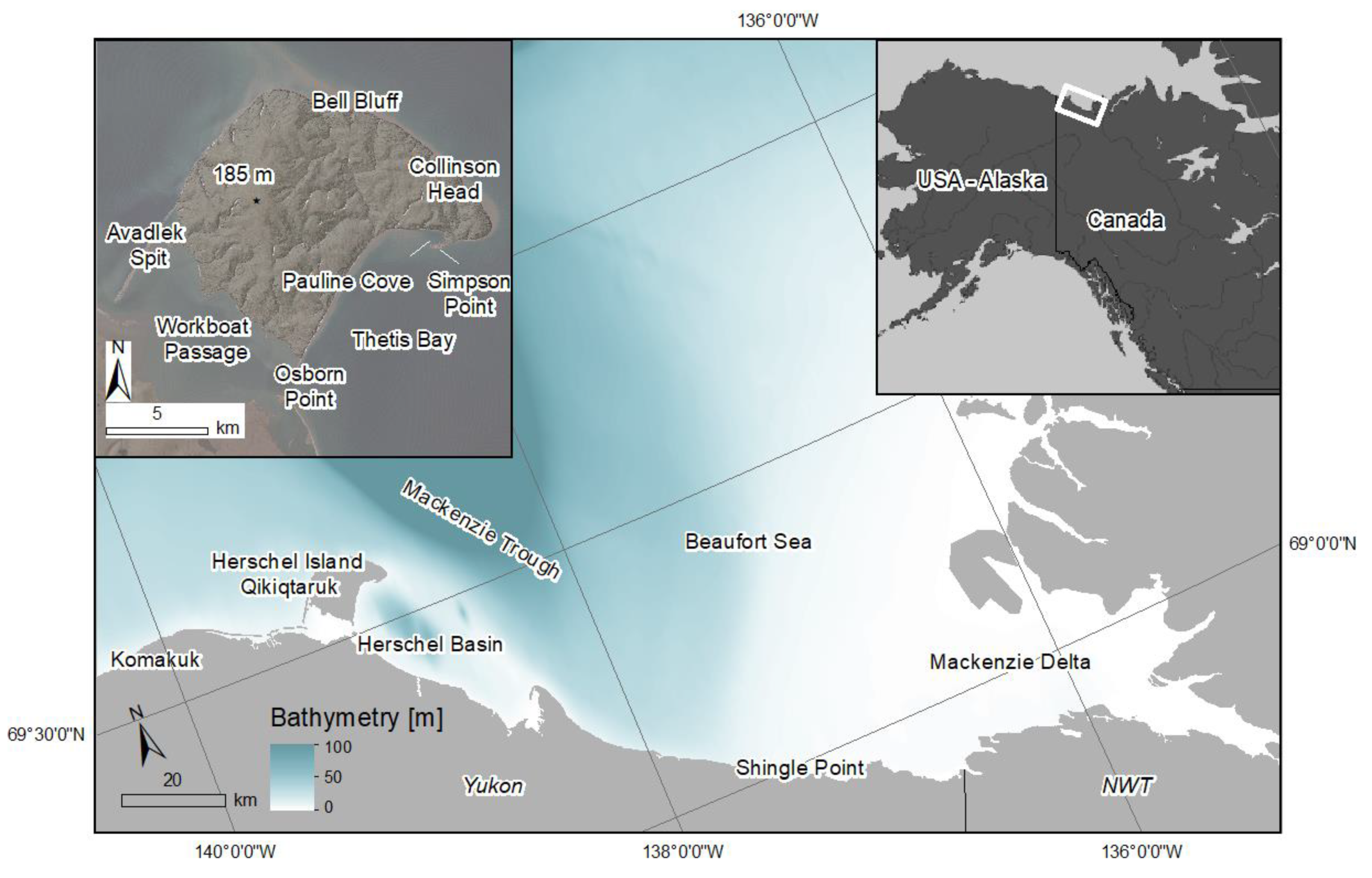
2.1. Regional Setting
2.2. Landsat Images Acquisition and Processing
- Level 1T data in the red and near infrared (NIR) channels are processed through the ACOLITE [18] atmospheric correction scheme to provide the remote sensing reflectance (RRS) and the water turbidity.
- Level 1T data in the thermal infrared are used to derive brightness temperature at the top-of-atmosphere.
- In addition, we use the L2 surface reflectance (RS) product as a means to quality control the ACOLITE-derived remote sensing reflectance (RRS) values.
2.3. Landsat Turbidity Retrieval
2.4. Transects in the Nearshore Zone
2.5. Wind Data
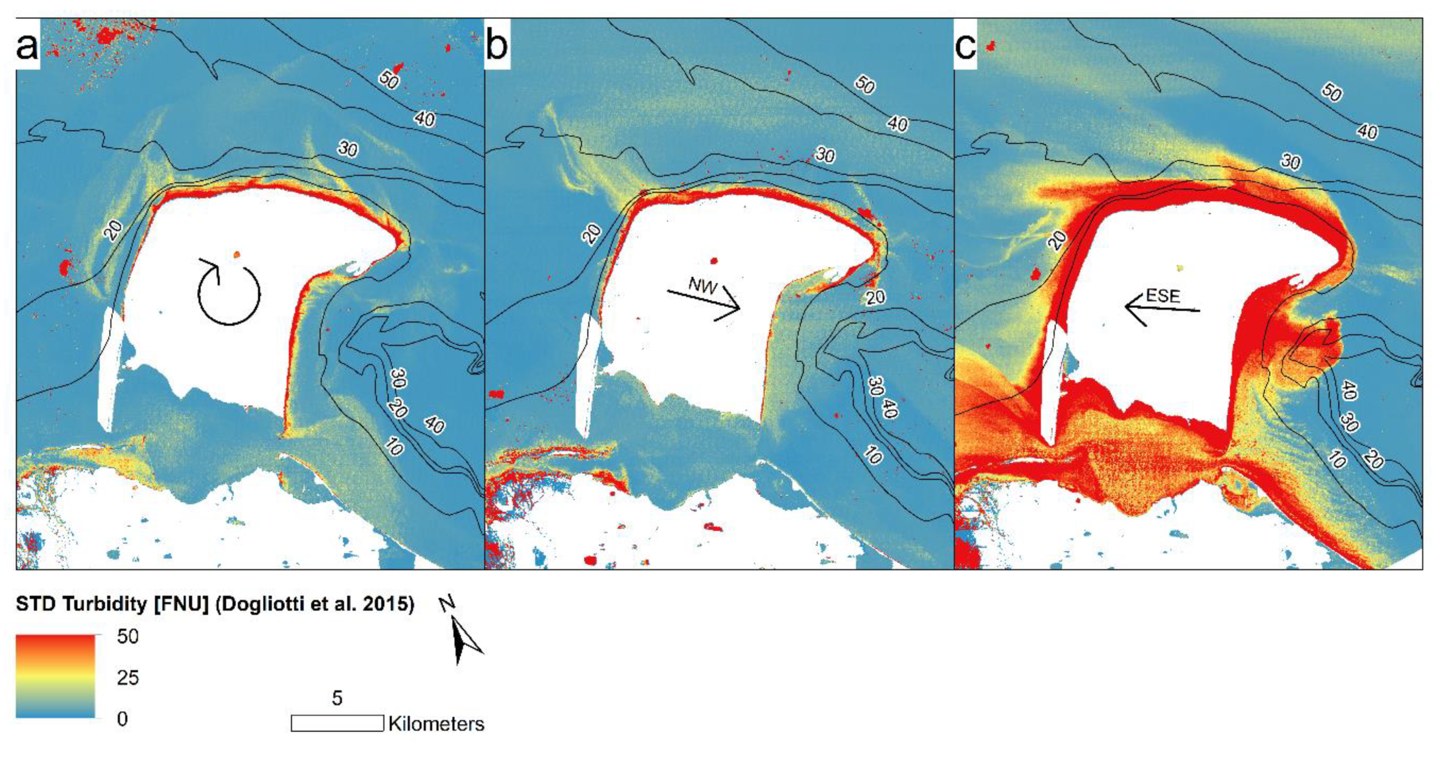
3. Results
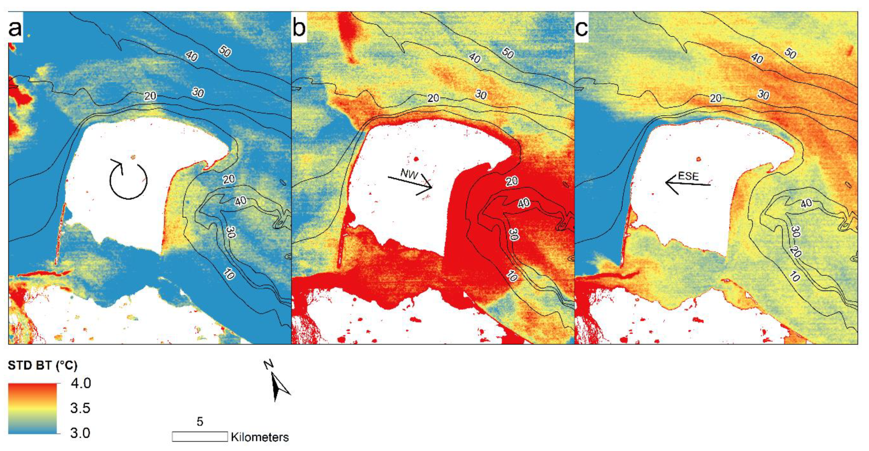
3.1. Brightness Temperature
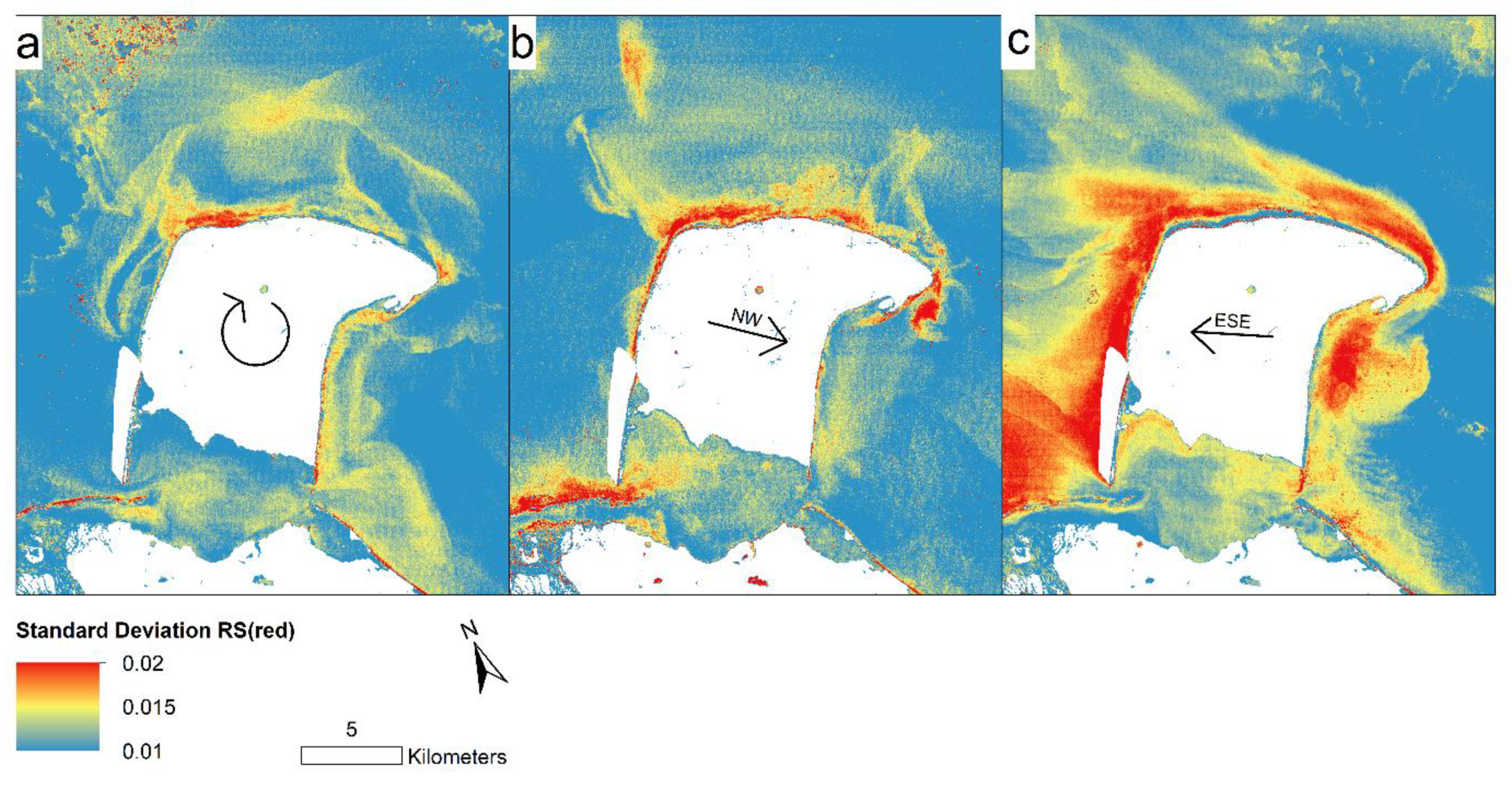
3.2. Surface Reflectance and Turbidity Mapping
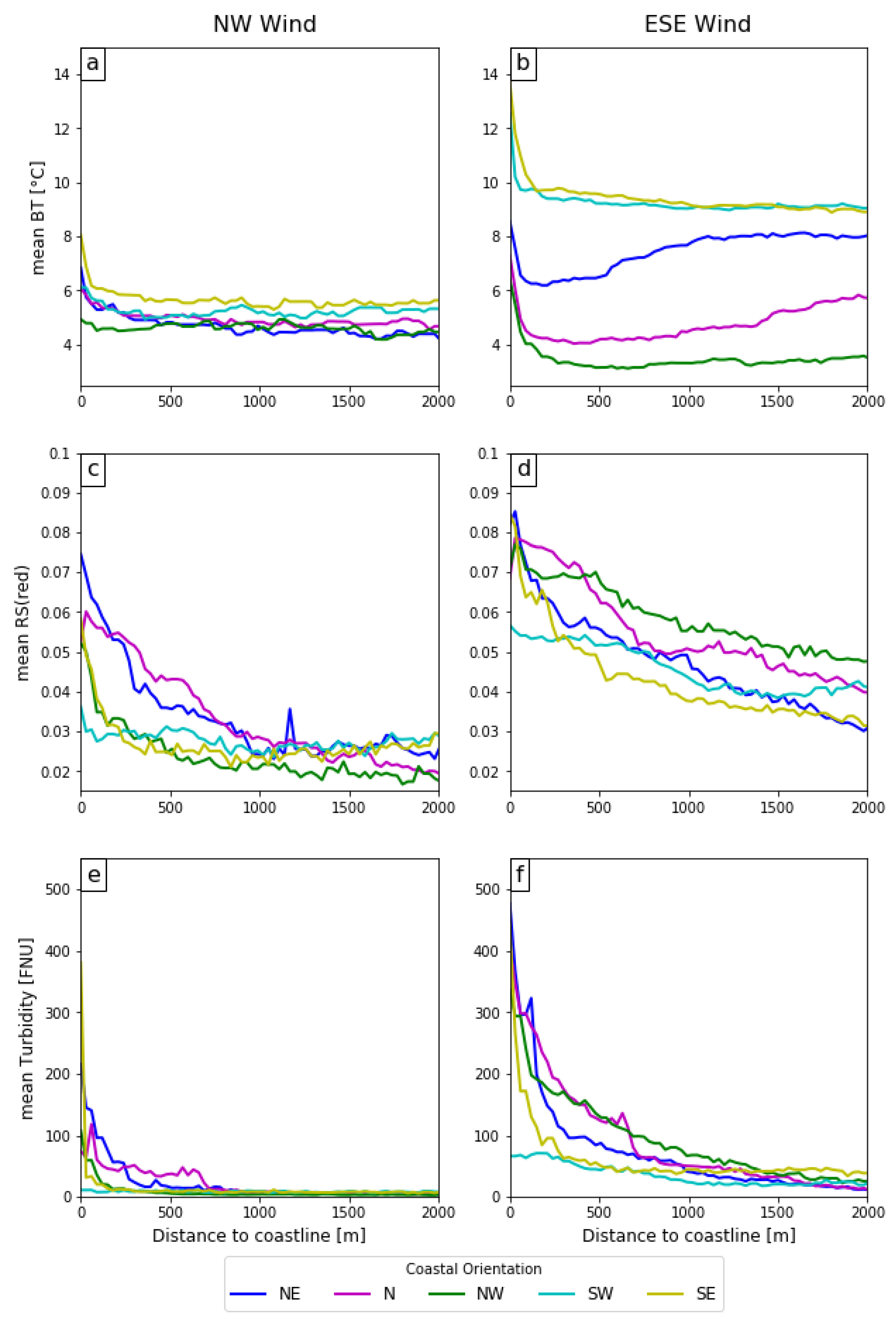
3.3. Gradients in the Nearshore Zone
4. Discussion
5. Conclusions
Author Contributions
Funding
Acknowledgments
Conflicts of Interest
Appendix A


References
- Stocker, T.F.; Qin, D.; Plattner, G.-K.; Tignor, M.; Allen, S.K.; Boschung, J.; Nauels, A.; Xia, Y.; Bex, V.; Midgley, P.M. (Eds.) IPCC: Climate Change 2013. The Physical Science Basis; Cambridge University Press: Cambridge, UK; New York, NY, USA, 2013. [Google Scholar]
- Hugelius, G.; Strauss, J.; Zubrzycki, S.; Harden, J.W.; Schuur, E.A.G.; Ping, C.; Schirrmeister, L. Estimated stocks of circumpolar permafrost carbon with quantified uncertainty ranges and identified data gaps. Biogeoscience 2014, 11, 6573–6593. [Google Scholar] [CrossRef]
- Romanovsky, V.E.; Smith, S.L.; Christiansen, H.H. Permafrost thermal state in the polar northern hemisphere during the international polar year 2007–2009: A synthesis. Permafr. Periglac. Process. 2010, 21, 106–116. [Google Scholar] [CrossRef]
- Vonk, J.E.; Sánchez-García, L.; van Dongen, B.E.; Alling, V.; Kosmach, D.; Charkin, A.; Semiletov, I.P.; Dudarev, O.V.; Shakhova, N.; Roos, P.; et al. Activation of old carbon by erosion of coastal and subsea permafrost in Arctic Siberia. Nature 2012, 489, 137–140. [Google Scholar] [CrossRef] [PubMed]
- Fritz, M.; Vonk, J.E.; Lantuit, H. Collapsing Arctic coastlines. Nat. Clim. Chang. 2017, 7, 6–7. [Google Scholar] [CrossRef]
- Déry, S.J.; Hernández-Henríquez, M.A.; Burford, J.E.; Wood, E.F. Observational evidence of an intensifying hydrological cycle in northern Canada. Geophys. Res. Lett. 2009, 36, 1–5. [Google Scholar] [CrossRef]
- McClelland, J.W.; Déry, S.J.; Peterson, B.J.; Holmes, R.M.; Wood, E.F. A pan-arctic evaluation of changes in river discharge during the latter half of the 20th century. Geophys. Res. Lett. 2006, 33, 2–5. [Google Scholar] [CrossRef]
- Jones, B.M.; Arp, C.D.; Jorgenson, M.T.; Hinkel, K.M.; Schmutz, J.A.; Flint, P.L. Increase in the rate and uniformity of coastline erosion in Arctic Alaska. Geophys. Res. Lett. 2009, 36, 1–5. [Google Scholar] [CrossRef]
- Yang, D.; Shi, X.; Marsh, P. Variability and extreme of Mackenzie River daily discharge during 1973–2011. Quat. Int. 2015, 380–381, 159–168. [Google Scholar] [CrossRef]
- Doxaran, D.; Devred, E.; Babin, M. A 50% increase in the mass of terrestrial particles delivered by the Mackenzie River into the Beaufort Sea (Canadian Arctic Ocean) over the last 10 years. Biogeosciences 2015, 12, 3551–3565. [Google Scholar] [CrossRef]
- Lantuit, H.; Overduin, P.P.; Wetterich, S. Recent progress regarding permafrost coasts. Permafr. Periglac. Process. 2013, 24, 120–130. [Google Scholar] [CrossRef]
- Lantuit, H.; Overduin, P.P.; Couture, N.; Wetterich, S.; Aré, F.; Atkinson, D.; Brown, J.; Cherkashov, G.; Drozdov, D.; Donald Forbes, L.; et al. The Arctic Coastal Dynamics Database: A New Classification Scheme and Statistics on Arctic Permafrost Coastlines. Estuaries Coasts 2012, 35, 383–400. [Google Scholar] [CrossRef]
- Tanski, G.; Wagner, D.; Knoblauch, C.; Fritz, M.; Sachs, T.; Lantuit, H. Rapid CO 2 release from eroding permafrost in seawater. Geophys. Res. Lett. 2019, 46, 11244–11252. [Google Scholar] [CrossRef]
- Arrigo, K.R.; van Dijken, G.; Pabi, S. Impact of a shrinking Arctic ice cover on marine primary production. Geophys. Res. Lett. 2008, 35, 1–6. [Google Scholar] [CrossRef]
- Carmack, E.; Wassmann, P. Food webs and physical-biological coupling on pan-Arctic shelves: Unifying concepts and comprehensive perspectives. Prog. Oceanogr. 2006, 71, 446–477. [Google Scholar] [CrossRef]
- Dunton, K.H.; Weingartner, T.; Carmack, E.C. The nearshore western Beaufort Sea ecosystem: Circulation and importance of terrestrial carbon in arctic coastal food webs. Prog. Oceanogr. 2006, 71, 362–378. [Google Scholar] [CrossRef]
- Hilker, T.; Wulder, M.A.; Coops, N.C.; Linke, J.; McDermid, G.; Masek, J.G.; Gao, F.; White, J.C. A new data fusion model for high spatial-and temporal-resolution mapping of forest disturbance based on Landsat and MODIS. Remote Sens. Environ. 2009, 113, 1613–1627. [Google Scholar] [CrossRef]
- Vanhellemont, Q.; Ruddick, K. Turbid wakes associated with offshore wind turbines observed with Landsat 8. Remote Sens. Environ. 2014, 145, 105–115. [Google Scholar] [CrossRef]
- Ritchie, J.C.; Cooper, C.M.; Schiebe, F.R. The relationship of MSS and TM digital data with suspended sediments, chlorophyll, and temperature in Moon Lake, Mississippi. Remote Sens. Environ. 1990, 33, 137–148. [Google Scholar] [CrossRef]
- Vanhellemont, Q.; Ruddick, K. Remote Sensing of Environment Advantages of high quality SWIR bands for ocean colour processing: Examples from Landsat-8. Remote Sens. Environ. 2015, 161, 89–106. [Google Scholar] [CrossRef]
- Doerffer, R.; Fischer, J.; Stössel, M.; Brockmann, C.; Grassl, H. Analysis of thematic mapper data for studying the suspended matter distribution in the coastal area of the German Bight (North Sea). Remote Sens. Environ. 1989, 28, 61–73. [Google Scholar] [CrossRef]
- Obu, J.; Lantuit, H.; Fritz, M.; Pollard, W.H.; Sachs, T.; Günther, F. Relation between planimetric and volumetric measurements of permafrost coast erosion: A case study from Herschel Island, western Canadian Arctic. Polar Res. 2016, 35, 1–13. [Google Scholar] [CrossRef]
- Doxaran, D.; Ehn, J.; Bélanger, S.; Matsuoka, A.; Hooker, S.; Babin, M. Optical characterisation of suspended particles in the Mackenzie River plume (Canadian Arctic Ocean) and implications for ocean colour remote sensing. Biogeosciences 2012, 9, 3213–3229. [Google Scholar] [CrossRef]
- Lantuit, H.; Pollard, W.H. Fifty years of coastal erosion and retrogressive thaw slump activity on Herschel Island, southern Beaufort Sea, Yukon Territory, Canada. Geomorphology 2008, 95, 84–102. [Google Scholar] [CrossRef]
- Couture, N.J.; Irrgang, A.; Pollard, W.; Lantuit, H.; Fritz, M. Coastal Erosion of Permafrost Soils along the Yukon Coastal Plain and Fluxes of Organic Carbon to the Canadian Beaufort Sea. Biogeoscience 2018, 123, 406–422. [Google Scholar] [CrossRef]
- Stein, R.; MacDonald, R.W. The Organic Carbon Cycle in the Arctic Ocean, 1st ed.; Stein, R., Macdonald, R.W., Eds.; Springer: Berlin/Heidelberg, Germany, 2014; ISBN 978-3-540-01153-8. [Google Scholar]
- O’Brien, M.C.; Macdonald, R.W.; Melling, H.; Iseki, K. Particle fluxes and geochemistry on the Canadian Beaufort Shelf: Implications for sediment transport and deposition. Cont. Shelf Res. 2006, 26, 41–81. [Google Scholar] [CrossRef]
- Burn, C.R.; Hattendorf, J.B. Toponymy of Herschel Island (Qikiqtaryuk), Western Arctic Coast, Canada. Arctic 2011, 64, 459–464. [Google Scholar] [CrossRef][Green Version]
- Holmes, R.M.; McClelland, J.W.; Peterson, B.J.; Shiklomanov, I.A.; Shiklomanov, A.I.; Zhulidov, A.V.; Gordeev, V.V.; Bobrovitskaya, N.N. A circumpolar perspective on fluvial sediment flux to the Arctic ocean. Glob. Biogeochem. Cycles 2002, 16, 1098. [Google Scholar] [CrossRef]
- Mulligan, R.P.; Perrie, W.; Solomon, S. Dynamics of the Mackenzie River plume on the inner Beaufort shelf during an open water period in summer. Estuar. Coast. Shelf Sci. 2010, 89, 214–220. [Google Scholar] [CrossRef]
- Pelletier, B.R.; Medioli, B.E. Environmental Atlas of the Beaufort Coastlands; Geological Survey of Canada Open File 7619; 2014; Available online: http://www.publications.gc.ca/site/fra/480362/publication.html.
- Forbes, D.L. Coastal Erosion and Nearshore Variability in the Southern Beaufort Sea, Ivvavik National Park, Yukon Territory; Darthmouth: Halifax, NS, Canada, 1997. [Google Scholar]
- Hill, P.R.; Blasco, S.M.; Harper, J.R.; Fissel, D.B. Sedimentation on the Canadian Beaufort Shelf. Cont. Shelf Res. 1991, 11, 821–842. [Google Scholar] [CrossRef]
- Mackay, J.R. The Origin of Massive Icy Beds in Permafrost, Western Arctic Coast, Canada. Can. J. Earth Sci. 1971, 8, 397–422. [Google Scholar] [CrossRef]
- Giovando, L.F.; Herlinveaux, R.H. A Discussion of Factors Influencing Dispersion of Pollutans in the Beaufort Sea. Pac. Mar. Sci. Rep. 1981, 81, 4. [Google Scholar]
- Burn, C.R.; Zhang, Y. Permafrost and climate change at Herschel Island (Qikiqtaruq), Yukon Territory, Canada. J. Geophys. Res. 2009, 114, 1–16. [Google Scholar] [CrossRef]
- Atkinson, D.E. Observed storminess patterns and trends in the circum-Arctic coastal regime. Geo-Mar. Lett. 2005, 25, 98–109. [Google Scholar] [CrossRef]
- Radosavljevic, B.; Lantuit, H.; Pollard, W.; Overduin, P.; Couture, N.; Sachs, T.; Helm, V.; Fritz, M. Erosion and Flooding—Threats to Coastal Infrastructure in the Arctic: A Case Study from Herschel Island, Yukon Territory, Canada. Estuaries Coasts 2015, 39, 900–915. [Google Scholar] [CrossRef]
- Government of Canada Historical Weather Data. Available online: http://climate.weather.gc.ca/historical_data/search_historic_data_e.html (accessed on 20 July 2018).
- USGS Earth Explorer. Available online: https://earthexplorer.usgs.gov (accessed on 16 January 2019).
- Storey, J.; Scaramuzza, P.; Schmidt, G.; Barsi, J. Landsat 7 Scan Line Corrector-Off Gap-Filled Product Gap-Filled Product Development Process. In Proceedings of the Global Priorities in Land Remote Sensing, Sioux Falls, SD, USA, 23–27 October 2005. [Google Scholar]
- MacFarlane, N.; Robinson, I.S. Atmospheric correction of LANDSAT MSS data for a multidate suspended sediment algorithm. Int. J. Remote Sens. 1984, 5, 561–576. [Google Scholar] [CrossRef]
- Dogliotti, A.I.; Ruddick, K.G.; Nechad, B.; Doxaran, D.; Knaeps, E. A single algorithm to retrieve turbidity from remotely-sensed data in all coastal and estuarine waters. Remote Sens. Environ. 2015, 156, 157–168. [Google Scholar] [CrossRef]
- Fischer, A.M.; Pang, D.; Kidd, I.M.; Moreno-Madriñán, M.J. Spatio-Temporal Variability in a Turbid and Dynamic Tidal Estuarine Environment (Tasmania, Australia): An Assessment of MODIS Band 1 Reflectance. Int. J. Geo-Inf. 2017, 6, 320. [Google Scholar] [CrossRef]
- Petus, C.; Marieu, V.; Novoa, S.; Chust, G.; Bruneau, N.; Froidefond, J.M. Monitoring spatio-temporal variability of the Adour River turbid plume (Bay of Biscay, France) with MODIS 250-m imagery. Cont. Shelf Res. 2014, 74, 35–49. [Google Scholar] [CrossRef]
- Doxaran, D.; Froidefond, J.M.; Castaing, P.; Babin, M. Dynamics of the turbidity maximum zone in a macrotidal estuary (the Gironde, France): Observations from field and MODIS satellite data. Estuar. Coast. Shelf Sci. 2009, 81, 321–332. [Google Scholar] [CrossRef]
- Baughman, C.A.; Jones, B.M.; Bartz, K.K.; Young, D.B.; Zimmerman, C.E. Reconstructing Turbidity in a Glacially Influenced Lake Using the Landsat TM and ETM+ Surface Reflectance Climate Data Record Archive, Lake Clark, Alaska. Remote Sens. 2015, 151, 13692–13710. [Google Scholar] [CrossRef]
- Masek, J.G.; Vermote, E.F.; Saleous, N.E.; Wolfe, R.; Hall, F.G.; Huemmrich, K.F.; Gao, F.; Kutler, J.; Lim, T.K. A landsat surface reflectance dataset for North America, 1990–2000. IEEE Geosci. Remote Sens. Lett. 2006, 3, 68–72. [Google Scholar] [CrossRef]
- Vanhellemont, Q. Remote Sensing of Environment Adaptation of the dark spectrum fi tting atmospheric correction for aquatic applications of the Landsat and Sentinel-2 archives. Remote Sens. Environ. 2019, 225, 175–192. [Google Scholar] [CrossRef]
- Novoa, S.; Doxaran, D.; Ody, A.; Vanhellemont, Q.; Lafon, V.; Lubac, B.; Gernez, P. Atmospheric Corrections and Multi-Conditional Algorithm for Multi-Sensor Remote Sensing of Suspended Particulate Matter in Low-to-High Turbidity Levels Coastal Waters. Remote Sens. 2017, 9, 61. [Google Scholar] [CrossRef]
- Foga, S.; Scaramuzza, P.L.; Guo, S.; Zhu, Z.; Dilley, R.D.; Beckmann, T.; Schmidt, G.L.; Dwyer, J.L.; Joseph Hughes, M.; Laue, B. Cloud detection algorithm comparison and validation for operational Landsat data products. Remote Sens. Environ. 2017, 194, 379–390. [Google Scholar] [CrossRef]
- Barsi, J.A.; Schott, J.R.; Hook, S.J.; Raqueno, N.G.; Markham, B.L.; Radocinski, R.G. Landsat-8 Thermal Infrared Sensor (TIRS) Vicarious Radiometric Calibration. Remote Sens. 2014, 6, 11607–11626. [Google Scholar] [CrossRef]
- Wukelic, G.E.; Gibbons, D.E.; Martucci, L.M.; Foote, H.P. Radiometric calibration of Landsat Thematic Mapper thermal band. Remote Sens. Environ. 1989, 28, 339–347. [Google Scholar] [CrossRef]
- Gippel, C.J. Potential of turbidity monitoring for measureing the transport of suspended solids in streams. Hydrol. Process. 1995, 9, 83–97. [Google Scholar] [CrossRef]
- Hussain, I.; Ahamad, K.; Nath, P. Water tutbidity sensing using a smartphone. RSC Adv. 2016, 6, 22374–22382. [Google Scholar] [CrossRef]
- Bailard, J.A. Modeling On-Offshore Sediment Transport in the Surfzone. Coast. Eng. 1982, 1419–1438. [Google Scholar]
- Hill, P.R.; Nadeau, O.C. Storm-dominated sedimentation on the inner shelf of the Canadian Beaufort Sea. J. Sediment. Res. 1989, 59, 455–468. [Google Scholar]
- Pfalz, G. Lateral Transport of Sediment and Organic Matter, Derived from Coastal Erosion, into the Nearshore Zone of the Southern Beaufort Sea, Canada; Technische Universität Dresden: Dresden, Germany, 2017. [Google Scholar]
- Riedel, T. Assessing Permafrost Erosion in the Canadian Beaufort Sea, Herschel Island–A Biomarker Approach; Universität Bremen: Bremen, Germany, 2017. [Google Scholar]
- Bloesch, J. Inshore-Offshore Sedimentation Differences Resulting from Resuspension in the Eastern Basin of Lake Erie. Can. J. Fish. Aquat. Sci. 1982, 39, 748–759. [Google Scholar] [CrossRef]
- Héquette, A.; Hill, P.R. Storm-generated currents and offshore sediment transport on a sandy shoreface, Tibjak Beach, Canadian Beaufort Sea. Mar. Geol. 1993, 113, 283–304. [Google Scholar] [CrossRef]
- Williams, W.J.; Carmack, E.C.; Shimada, K.; Melling, H.; Aagaard, K.; Macdonald, R.W.; Grant Ingram, R. Joint effects of wind and ice motion in forcing upwelling in Mackenzie Trough, Beaufort Sea. Cont. Shelf Res. 2006, 26, 2352–2366. [Google Scholar] [CrossRef]
- Van Vliet, M.T.H.; Franssen, W.H.P.; Yearsley, J.R.; Ludwig, F.; Haddeland, I.; Lettenmaier, D.P.; Kabat, P. Global river discharge and water temperature under climate change. Glob. Environ. Chang. 2013, 23, 450–464. [Google Scholar] [CrossRef]


| Acquisition Date (YYYY-MM-DD) | Sensor | Path/Row | Wind Direction | Mean Wind Speed (km/h) |
|---|---|---|---|---|
| 1986-09-14 | TM | 67/11 | changing | 18.08 |
| 1990-08-17 | TM | 66/11 | ESE | 35.17 |
| 1990-09-16 | TM | 68/11 | NW | 14.50 |
| 1990-09-25 | TM | 67/11 | NW | 17.50 |
| 1992-08-06 | TM | 66/11 | ESE | 27.58 |
| 1992-08-20 | TM | 68/11 | changing | 24.75 |
| 1992-08-29 | TM | 67/11 | changing | 21.33 |
| 1994-07-27 | TM | 66/11 | changing | 11.08 |
| 1994-08-12 | TM | 66/11 | changing | 9.42 |
| 1994-09-11 | TM | 68/11 | ESE | 23.83 |
| 1995-07-12 | TM | 68/11 | ESE | 27.92 |
| 1997-07-19 | TM | 66/11 | ESE | 21.33 |
| 1997-08-02 | TM | 68/11 | NW | 38.92 |
| 1998-07-13 | TM | 67/11 | ESE | 15.00 |
| 1998-07-22 | TM | 66/11 | ESE | 29.08 |
| 1999-08-08 | TM | 68/11 | ESE | 23.00 |
| 1999-08-10 | TM | 66/11 | ESE | 27.42 |
| 1999-09-02 | TM | 67/11 | ESE | 16.75 |
| 1999-09-10 | ETM+ | 67/11 | ESE | 11.00 |
| 1999-09-18 | TM | 67/11 | ESE | 18.33 |
| 1999-09-26 | ETM+ | 67/11 | NW | 38.33 |
| 2001-08-30 | ETM+ | 67/11 | changing | 9.25 |
| 2002-09-11 | ETM+ | 66/11 | NW | 14.42 |
| 2004-08-22 | ETM+ | 67/11 | ESE | 21.42 |
| 2006-07-26 | TM | 68/11 | ESE | 29.33 |
| 2007-08-23 | TM | 67/11 | changing | 23.50 |
| 2008-06-30 | ETM+ | 67/11 | ESE | 21.33 |
| 2009-07-27 | TM | 67/11 | NW | 11.08 |
| 2009-08-21 | TM | 66/11 | changing | 12.17 |
| 2009-09-05 | ETM+ | 67/11 | NW | 10.92 |
| 2010-08-15 | TM | 67/11 | ESE | 19.58 |
| 2011-09-12 | TM | 66/11 | changing | 9.42 |
| 2013-07-15 | OLI | 66/11 | ESE | 18.00 |
| 2014-07-02 | OLI | 66/11 | NW | 16.50 |
| 2016-08-07 | ETM+ | 67/11 | ESE | 24.83 |
© 2019 by the authors. Licensee MDPI, Basel, Switzerland. This article is an open access article distributed under the terms and conditions of the Creative Commons Attribution (CC BY) license (http://creativecommons.org/licenses/by/4.0/).
Share and Cite
Klein, K.P.; Lantuit, H.; Heim, B.; Fell, F.; Doxaran, D.; Irrgang, A.M. Long-Term High-Resolution Sediment and Sea Surface Temperature Spatial Patterns in Arctic Nearshore Waters Retrieved Using 30-Year Landsat Archive Imagery. Remote Sens. 2019, 11, 2791. https://doi.org/10.3390/rs11232791
Klein KP, Lantuit H, Heim B, Fell F, Doxaran D, Irrgang AM. Long-Term High-Resolution Sediment and Sea Surface Temperature Spatial Patterns in Arctic Nearshore Waters Retrieved Using 30-Year Landsat Archive Imagery. Remote Sensing. 2019; 11(23):2791. https://doi.org/10.3390/rs11232791
Chicago/Turabian StyleKlein, Konstantin P., Hugues Lantuit, Birgit Heim, Frank Fell, David Doxaran, and Anna M. Irrgang. 2019. "Long-Term High-Resolution Sediment and Sea Surface Temperature Spatial Patterns in Arctic Nearshore Waters Retrieved Using 30-Year Landsat Archive Imagery" Remote Sensing 11, no. 23: 2791. https://doi.org/10.3390/rs11232791
APA StyleKlein, K. P., Lantuit, H., Heim, B., Fell, F., Doxaran, D., & Irrgang, A. M. (2019). Long-Term High-Resolution Sediment and Sea Surface Temperature Spatial Patterns in Arctic Nearshore Waters Retrieved Using 30-Year Landsat Archive Imagery. Remote Sensing, 11(23), 2791. https://doi.org/10.3390/rs11232791