Contribution to Sandy Site Characterization: Spectro-Directional Signature, Grain Size Distribution and Mineralogy Extracted from Sand Samples
Abstract
1. Introduction
2. Definition and Nomenclature of the Measured Physical Quantities
3. Materials
4. Methods
4.1. BCRF Measurement
- SZA is the Source Zenith Angle,
- VZA is the View Zenith Angle,
- VAA is the View Azimuthal Angle,
- λ is the wavelength,
- t is the measurement time,
- Ls is the measured radiance for the sample,
- Lref is the measured radiance for the reference panel,
- BCRFref is the BCRF of the reference panel,
- SZA0, VZA0 and VAA0 are the chosen angles for the radiance measurement of the reference panel,
- t0 is the reference panel measurement time.
- Put the samples in the laboratory the day before the measurements and open the boxes or bags,
- Put the sand in the plate and level it when switching the device on,
- Switch the temperature and humidity monitoring on,
- Warm up during 1 hour,
- Perform radiance measurement with the reference panel (SZA = 40 to 50°, step = 5°; VZA = 0°; VAA = 0° and 180°),
- Perform radiance measurement with the sand sample (SZA = 10 to 60°, step = 10°; VZA = 0° to 50°, step = 10°; VAA = 0° to 180°, step = 20°),
- Rotate the sample plate of 90° and perform a new radiance measurement,
- Rotate the sample plate of another 90° and perform another new radiance measurement,
- Perform another measurement with the reference panel (SZA = 40 to 50°, step = 5°; VZA = 0°; VAA = 0° and 180°),
- Switch all off,
- Collect between 9 and 35 g of the center sand surface for physical analysis.
4.2. Mineralogy
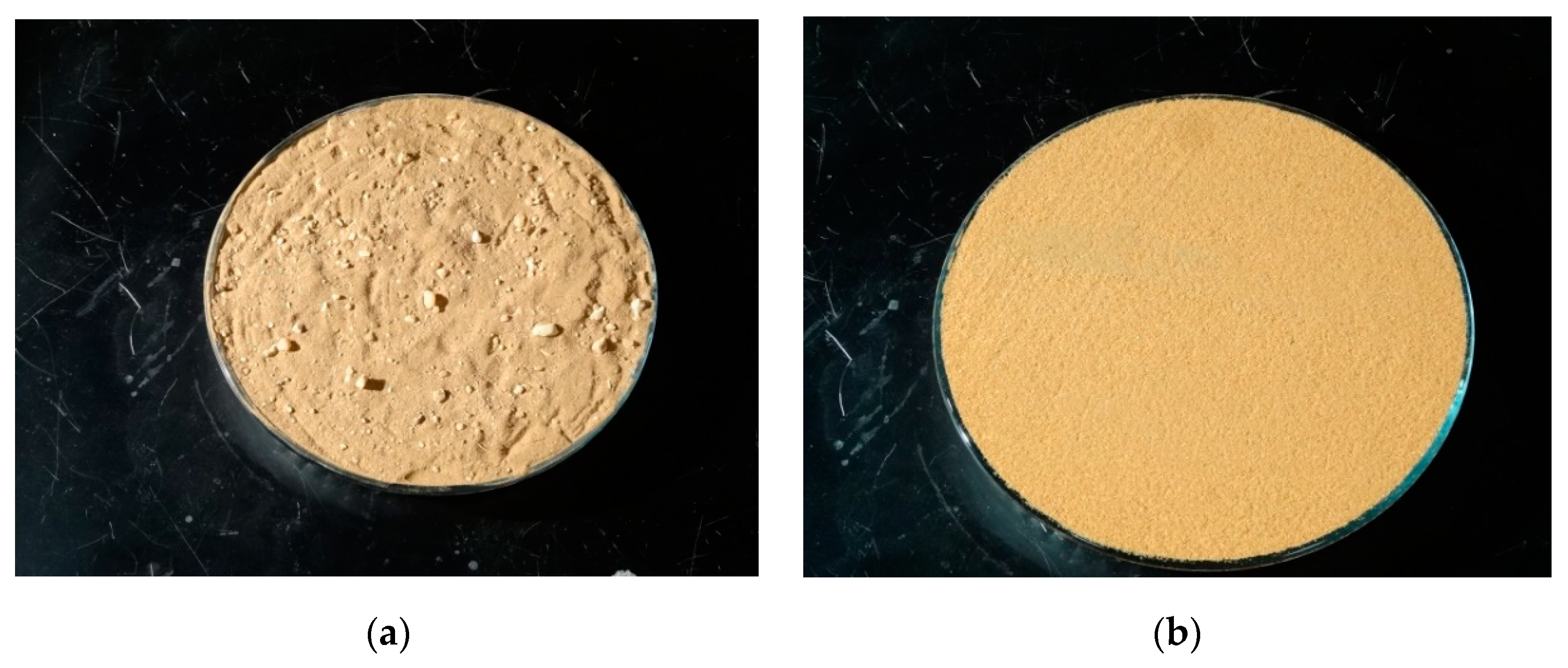
4.3. Grain Size Distribution
5. Results
5.1. BCRF Spectral Behavior
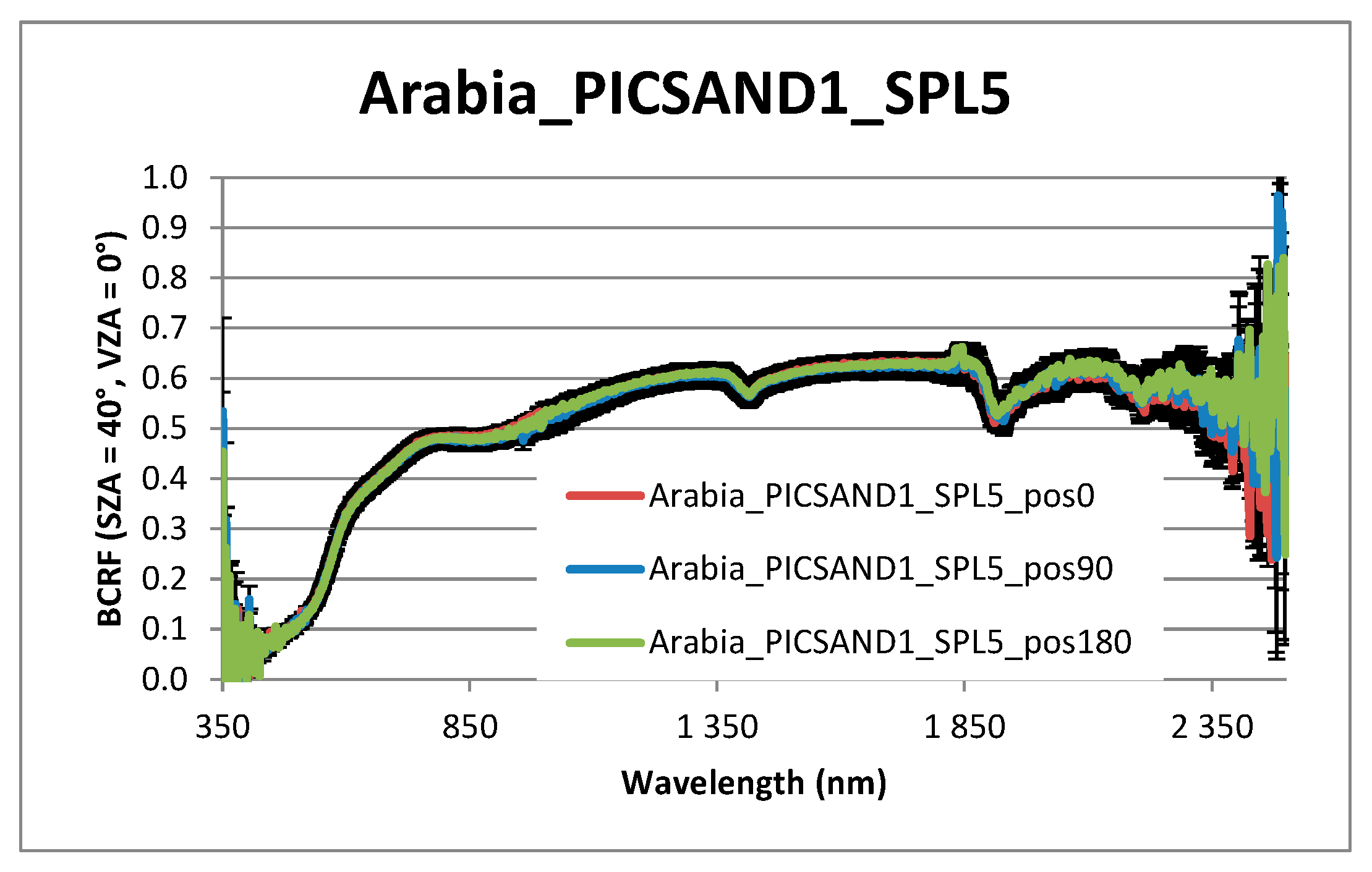
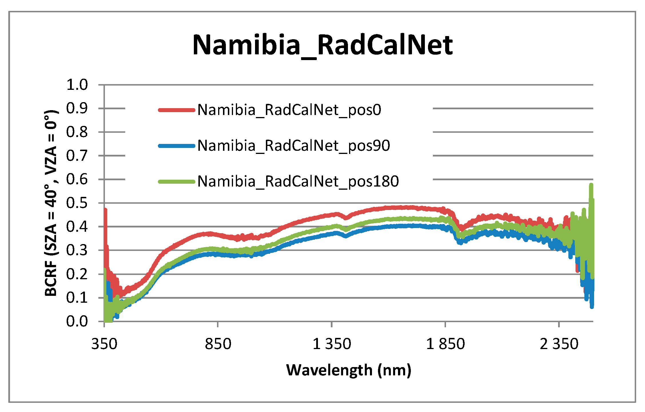
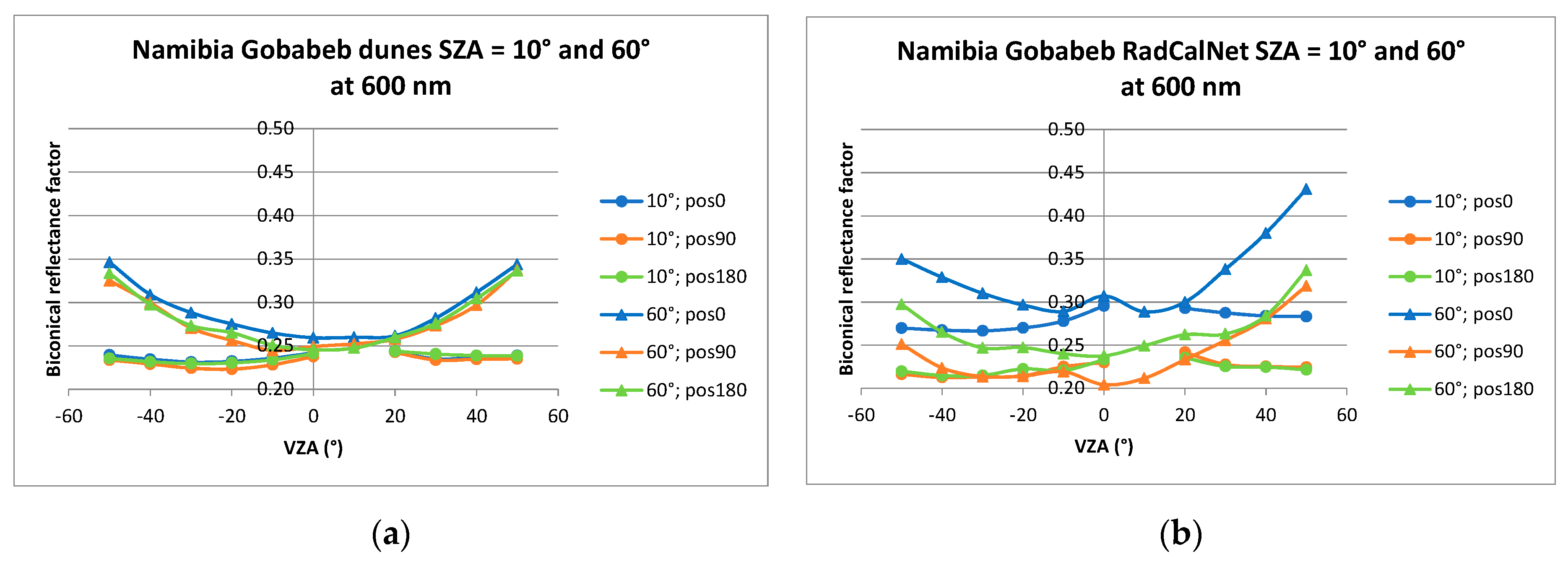
5.1.1. Consistency of the BCRF for the Different Sample Positions
5.1.2. Intra-Site Variability of BCRF
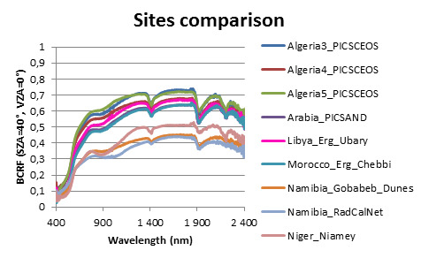
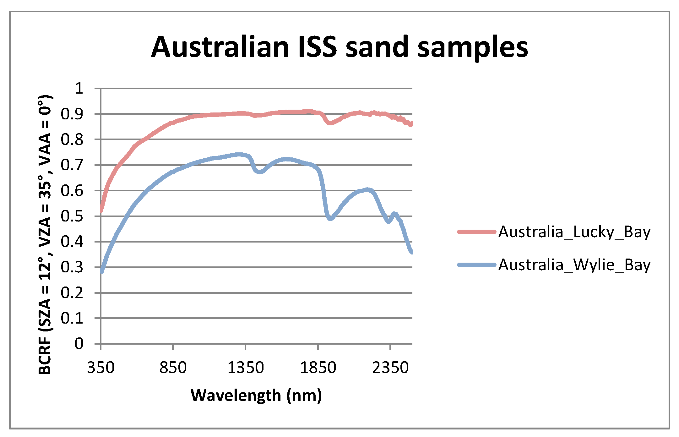
5.1.3. Inter-Site Variability of BCRF
5.1.4. Results for the Internal Soil Standard
5.2. BCRF Directional Behavior
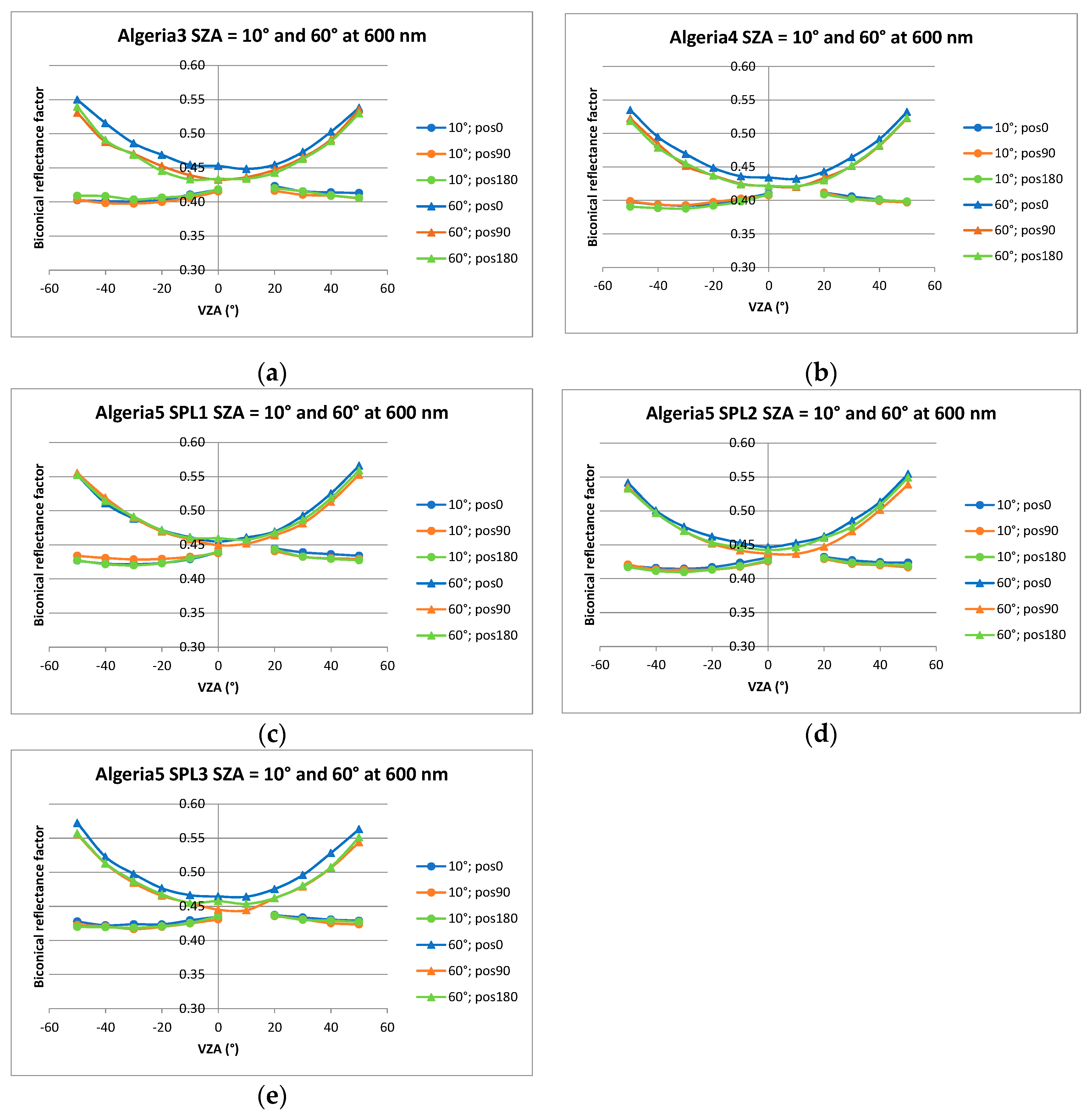
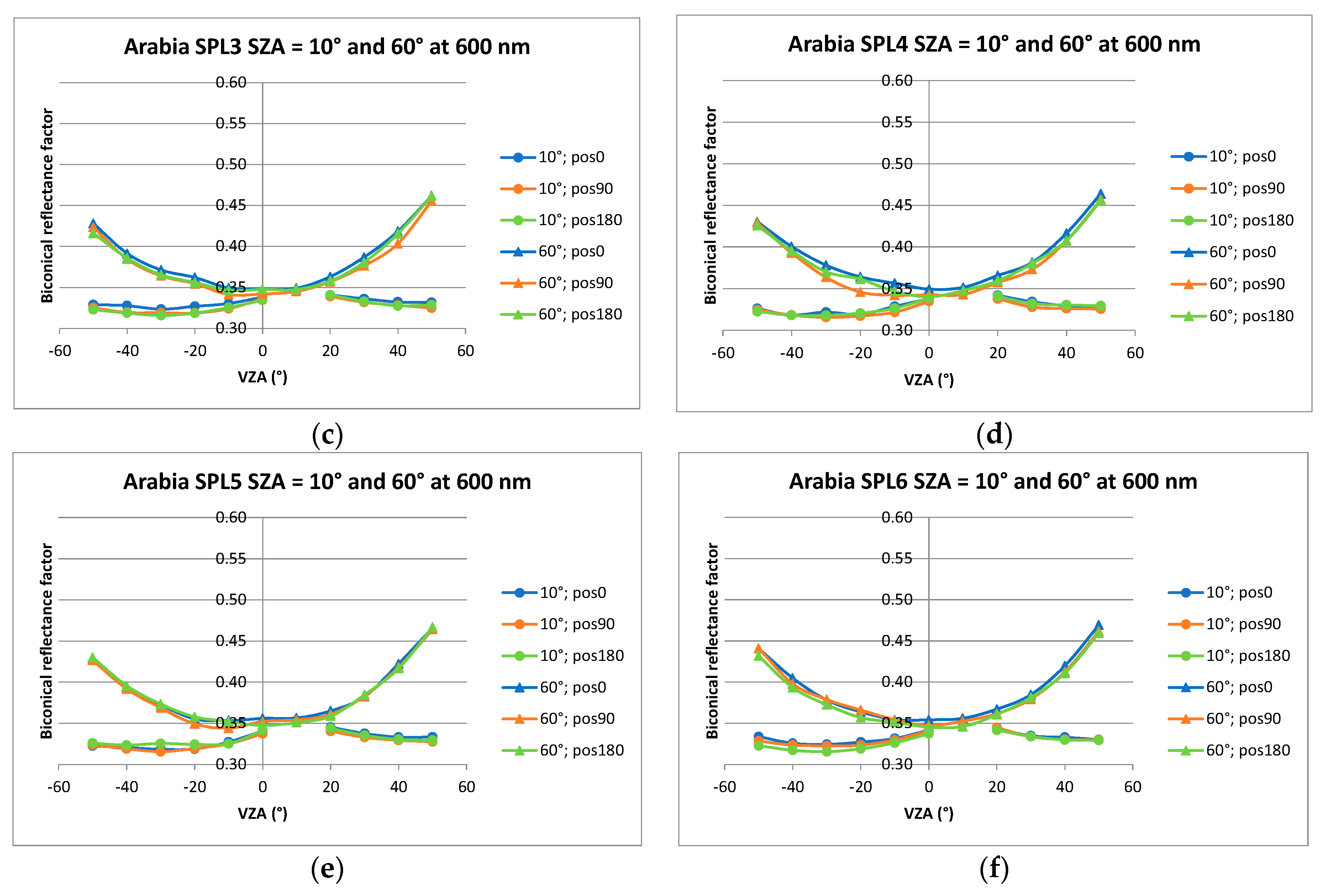
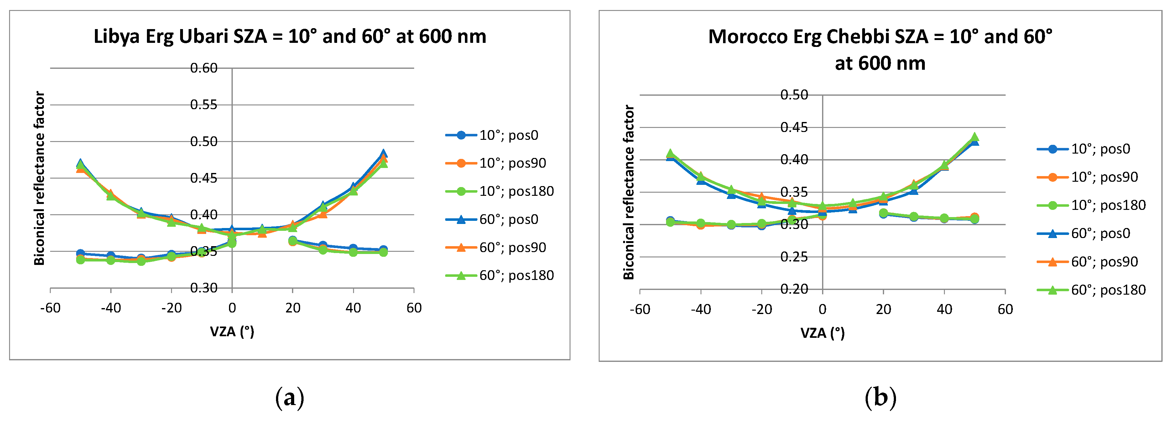
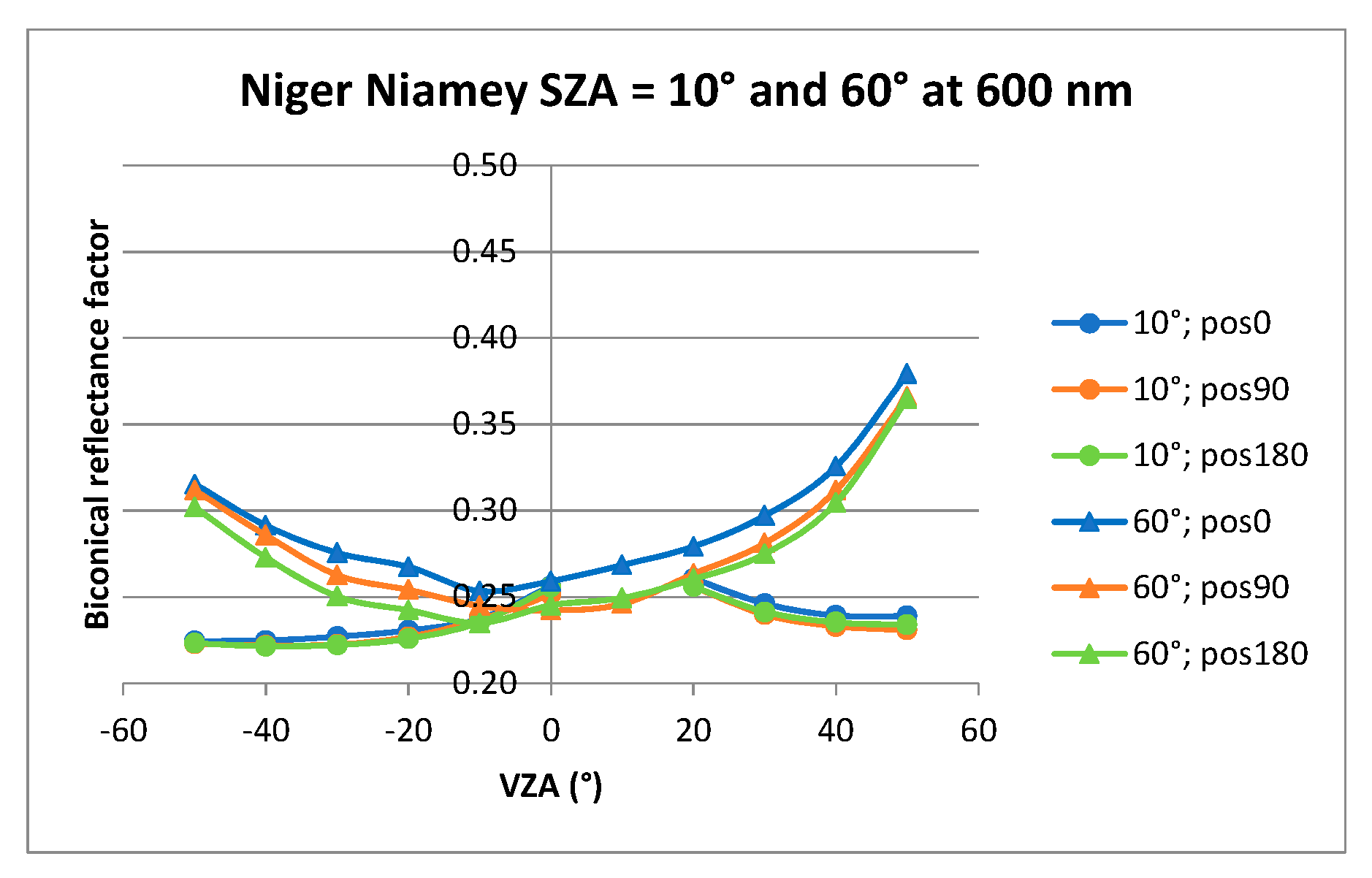
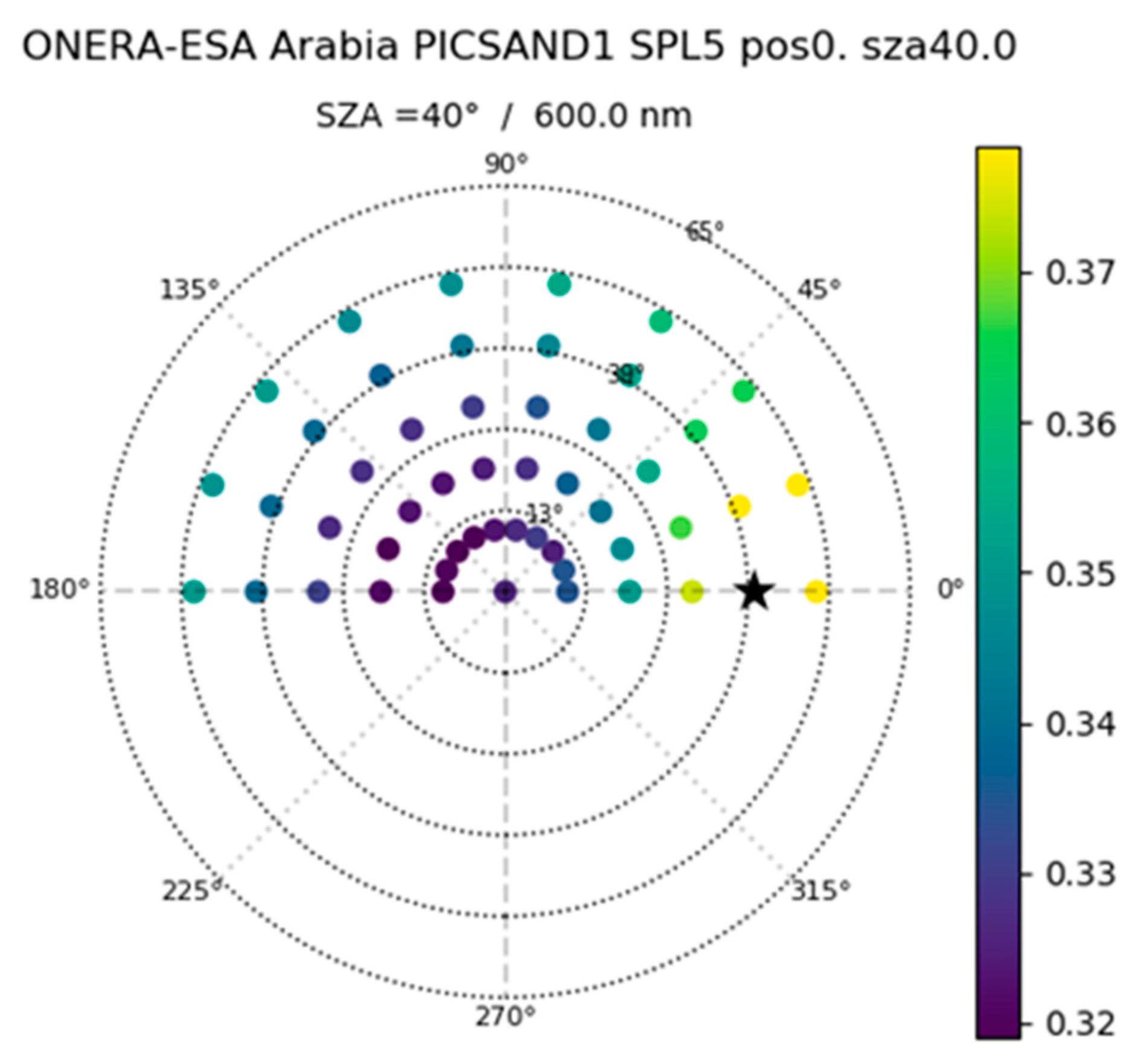
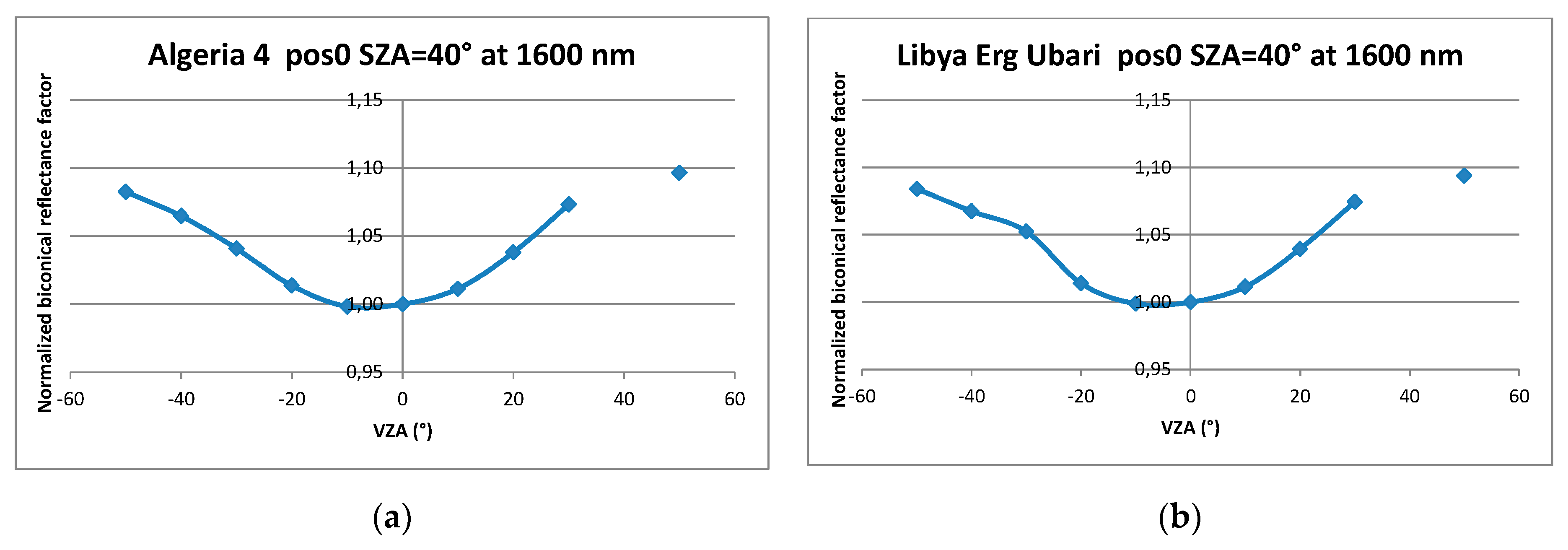
5.2.1. Analysis in the Principal Plane
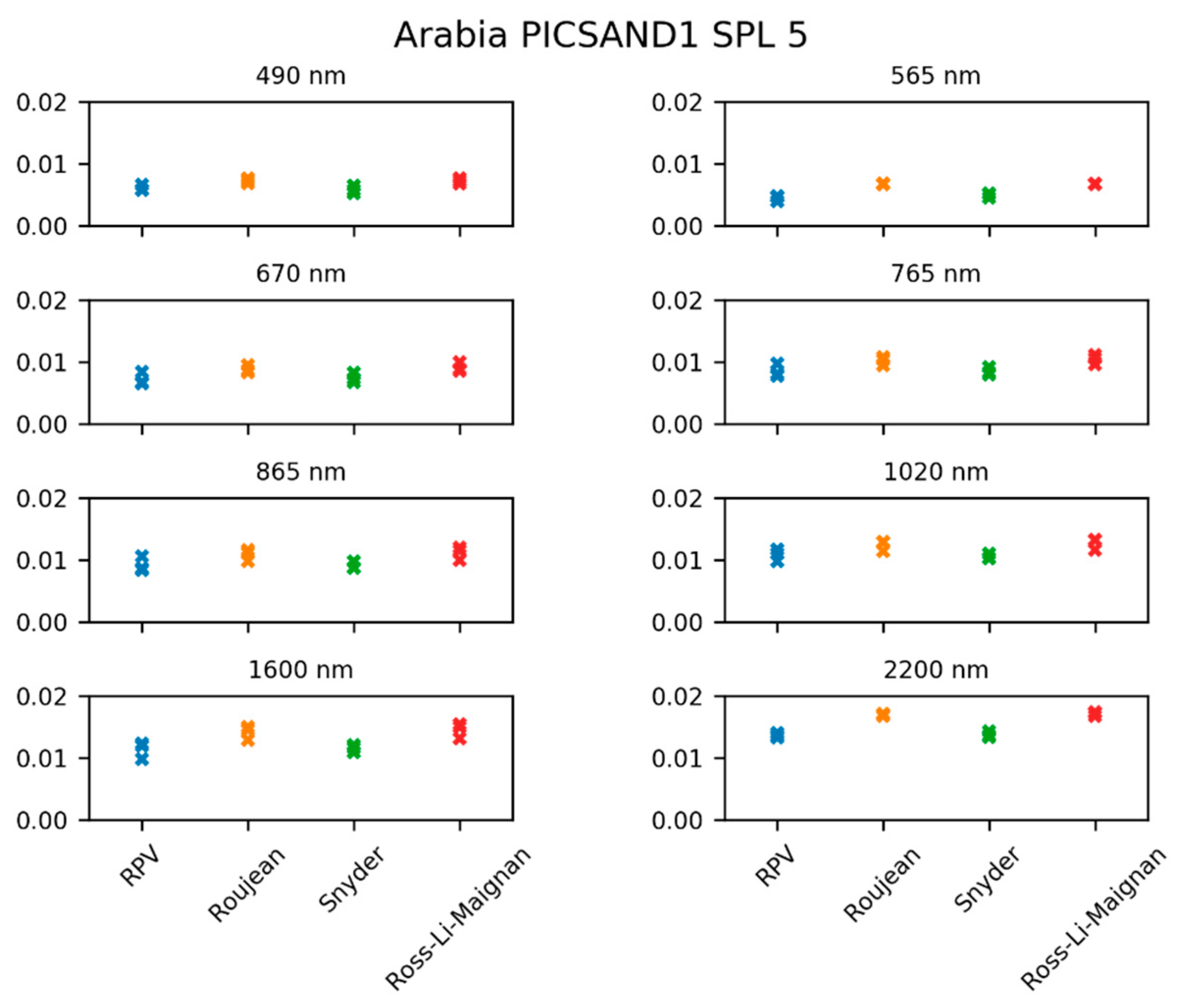
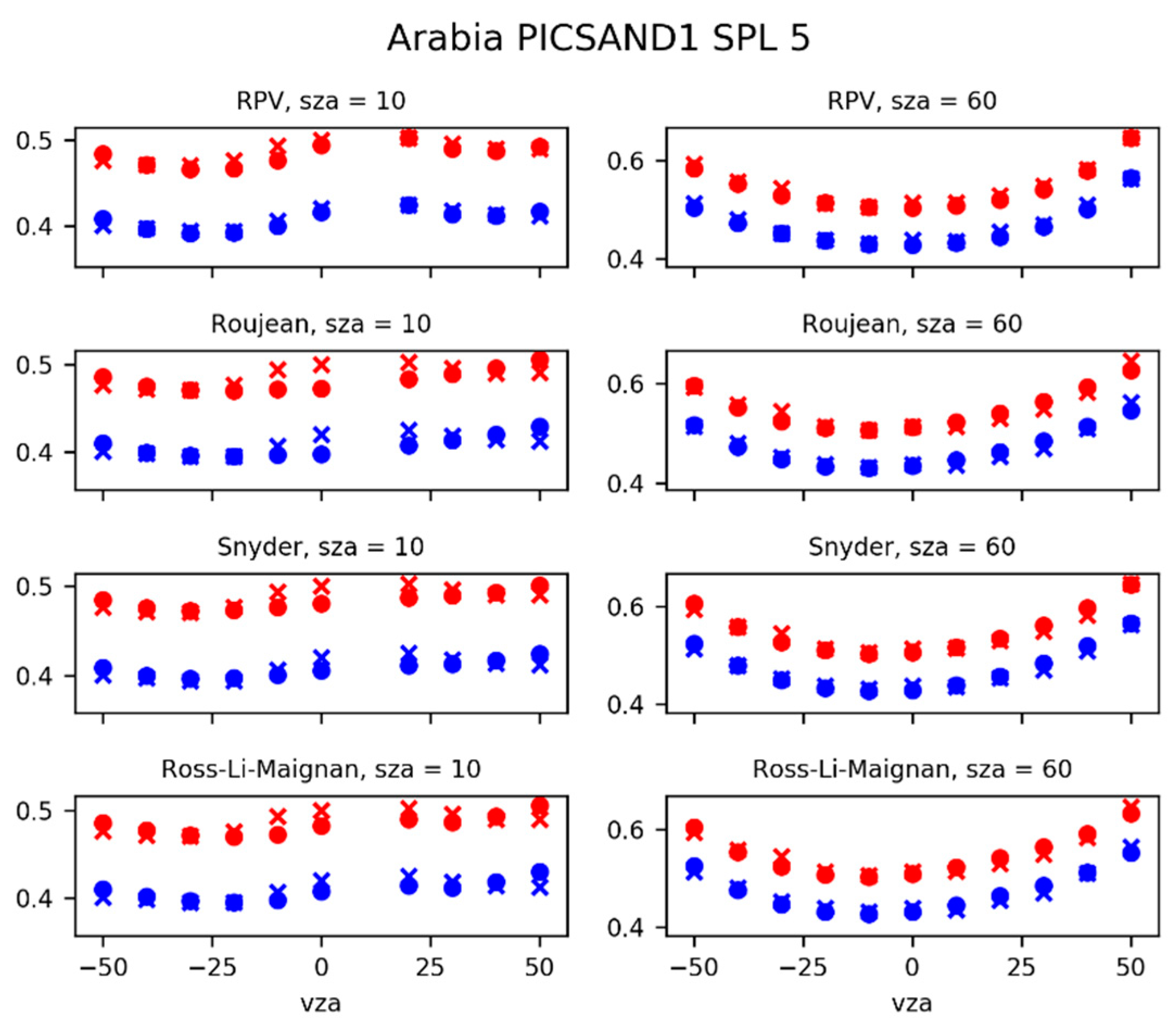
5.2.2. Reproducibility of Directional Signatures with BRDF Models
- the position 0° (pos0) of the samples,
- two wavelengths: 670 and 875 nm,
- two solar zenith angles (SZA): 10 and 60°.
5.3. Mineralogy
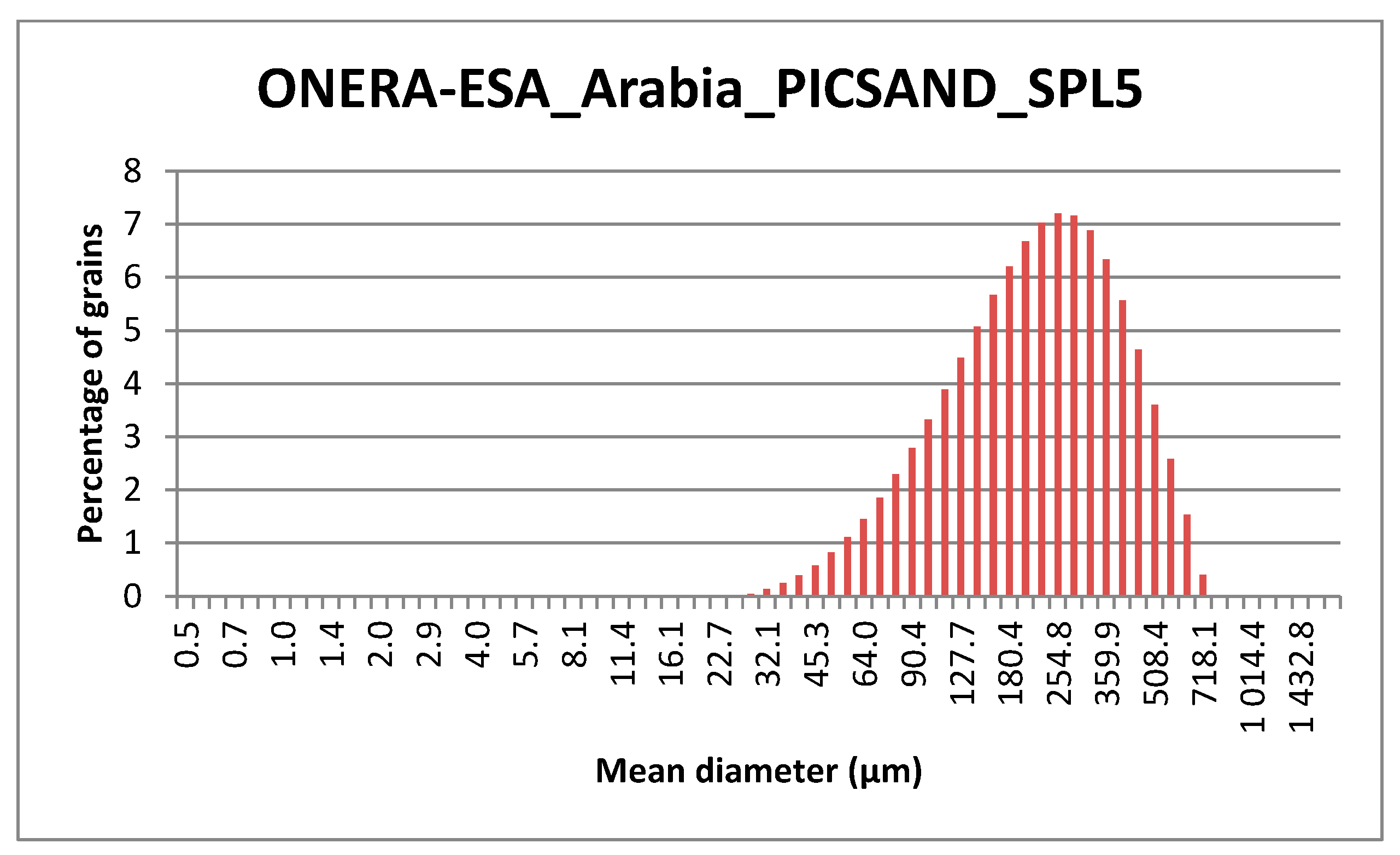
5.4. Grain Size Distribution
5.5. Overview of the PICSAND Database
6. Discussion
6.1. Spectral Shape
6.2. Directional Effects
6.3. Relationship between Laboratory and Space-Borne Measurements
7. Conclusions
Author Contributions
Funding
Acknowledgments
Conflicts of Interest
References
- Cosnefroy, H.; Briottet, X.; Leroy, M.; Lecomte, P.; Santer, R. A field experiment in Saharan Algeria for the calibration of optical sensors. Int. J. Remote Sens. 1997, 18, 3337–3359. [Google Scholar] [CrossRef]
- Tanré, D.; Bréon, F.M.; Deuzé, J.L.; Dubovik, O.; Ducos, F.; François, P.; Goloub, P.; Herman, M.; Lifermann, A.; Waquet, F. Remote sensing of aerosols by using polarized, directional and spectral measurements within the A-Train: The PARASOL mission. Atmos. Meas. Tech. 2011, 4, 1383–1395. [Google Scholar] [CrossRef]
- Bacour, C.; Briottet, X.; Bréon, F.M.; Viallefont-Robinet, F.; Bouvet, M. Revisiting Pseudo Invariant Calibration Sites (PICS) over sand deserts for vicarious calibration of optical imagers at 20 km and 100 km scales. Remote Sens. 2019, 11, 1166. [Google Scholar] [CrossRef]
- Bouvet, M. Radiometric comparison of multispectral imagers over a pseudo-invariant calibration site using a reference radiometric model. Remote Sens. Environ. 2014, 140, 141–154. [Google Scholar] [CrossRef]
- Henry, P.; Chander, G.; Fougnie, B.; Thomas, C.; Xiong, X. Assessment of Spectral Band Impact on Intercalibration Over Desert Sites Using Simulation Based on EO-1 Hyperion Data. IEEE Trans. Geosci. Remote Sens. 2013, 51, 1297–1308. [Google Scholar] [CrossRef]
- Govaerts, Y.M. Sand dune ridge alignment effects on surface BRF over the Libya-4 CEOS calibration site. Sensors 2015, 15, 3453–3470. [Google Scholar] [CrossRef]
- Nicodemus, F.E.; Richmond, J.C.; Hsia, J.J. Geometrical Considerations and Nomenclature for Reflectance; Final Report National Bureau of Standards; Inst. for Basic Standards: Washington, DC, USA, 1977.
- Fourest, S.; Briottet, X.; Lier, P.; Valorge, C. Satellite Imagery—From Acquisition Principles to Processing of Optical Images for Observing the Earth; Cépaduès Editions: Toulouse, France, 2012; p. 189. [Google Scholar]
- White, K.; Walden, J.; Gurney, S.D. Spectral properties, iron oxide content and provenance of Namib dune sands. Geomorphology 2006, 86, 219–229. [Google Scholar] [CrossRef]
- Bialek, A.; Greenwell, C.L.; Lamare, M.; Meygret, A.; Marcq, S.; Lacherade, S.; Woolliams, E.; Berthelot, B.; Bouvet, M.; King, M.; et al. New radiometric calibration site located at Gobabeb, Namib desert. In Proceedings of the IEEE International Geoscience and Remote Sensing Symposium (IGARSS), Beijing, China, 10–15 July 2016; pp. 6094–6097. [Google Scholar]
- Radiometric Calibration Network Portal. Available online: https://www.radcalnet.org (accessed on 21 October 2019).
- Ong, C.; Caccetta, M.; Lau, I.C.; Ong, L.; Middleton, E. Compositional characterization of the Pinnacles vicarious calibration site. In Proceedings of the IEEE International Geoscience and Remote Sensing Symposium (IGARSS), Fort Worth, TX, USA, 23–28 July 2017; pp. 3059–3062. [Google Scholar]
- Ben Dor, E.; Ong, C.; Lau, I.C. Reflectance measurements of soils in the laboratory: standards and protocols. Geoderma 2015, 245, 112–124. [Google Scholar] [CrossRef]
- Gellman, D.; Biggar, S.F.; Dinguirard, M.C.; Henry, P.J.; Moran, M.S.; Thome, K.J.; Slater, P.N. Review of SPOT-1 and -2 calibrations at White Sands from launch to the present. SPIE 1993, 1938, 118–125. [Google Scholar]
- Czapla-Myers, J.; Mc Corkel, J.; Anderson, N.; Biggar, S. Earth observing satellite intercomparison using the radiometric calibration test site at railroad Valley. J. Appl. Remote Sens. 2017, 12, 012004. [Google Scholar] [CrossRef]
- Boucher, Y.; Cosnefroy, H.; Petit, D.; Serrot, G.; Briottet, X. Comparison of Measured and Modeled BRDF of Natural Targets. In Proceedings of the SPIE Annual International Symposium AeroSense’99, Orlando, FL, USA, 5–9 April 1999; Volume 3699. [Google Scholar]
- Maignan, F.; Bréon, F.M.; Lacaze, R. Bidirectional reflectance of Earth targets: Analytical modeling and validation against a large data set of satellite measurements with emphasis on the Hot Spot. Remote Sens. Environ. 2004, 90, 210–220. [Google Scholar] [CrossRef]
- Roujean, J.L.; Leroy, M.; Deschamps, P.Y. A bidirectional reflectance model of the Earth’s surface for the correction of remote sensing data. J. Geophys. Res. 1992, 97, 455–468. [Google Scholar] [CrossRef]
- Rahman, H.; Pinty, B.; Verstraete, M.M. Coupled Surface-Atmosphere Reflectance (CSAR) Model 2. Semiempirical Surface Model Usable with NOAA Advanced Very High Resolution Radiometer Data. J. Geophys. Res. 1993, 98, 791–801. [Google Scholar] [CrossRef]
- Snyder, W.C.; Wan, Z. BRDF models to predict spectral reflectance and emissivity in the thermal intrared. IEEE Trans. Geosci. Remote Sens. 1998, 36, 214–225. [Google Scholar] [CrossRef]
- Press, W.E.; Teukolsky, S.A.; Vetterling, W.T.; Flannery, B.P. Downhill Simplex method in multidimensions. In Numerical Recipies in C: The Art of Scientific Computing, 2nd ed.; Cambridge University Press: New York, NY, USA, 1995; pp. 305–309. ISBN 0-521-43108-5. [Google Scholar]
- von Schönermark, M.; Geiger, B.; Röser, H.P. Reflection Properties of Vegetation and Soil; Wissenschaft und Technik Verlag: Berlin, Germany, 2004; pp. 259–286. ISBN 3-89685-565-4. [Google Scholar]
- Cierniewsky, J.; Karnieli, A. Virtual surfaces simulating the bidirectional reflectance of semiarid soils. Int. J. Remote Sens. 2003, 24, 1469–1486. [Google Scholar] [CrossRef]
- Coburn, C.; Gordon, S.; Logie, J. Temporal dynamics of sand dune bidirectional reflectance characteristics for absolute radiometric calibration of optical remote sensing data. Appl. Remote Sens. 2017, 12, 012006. [Google Scholar] [CrossRef]
- Suomalainen, J.; Hakala, T.; Peltoniemi, J.I.; Puttonen, E. Polarised multiangular reflectance measurements using the Finnish Geodetic Institute Field Goniospectrometer. Sensors 2009, 9, 3891–3907. [Google Scholar] [CrossRef]
- Peltoniemi, J.I.; Piironen, J.; Näränen, J.; Suomalainen, J.; Kuittinen, R.; Markelin, L.; Honkavaara, E. Bidirectional reflectance spectrometry of gravel at the Sjökulla test field. ISPRS J. Photogramm. Remote Sens. 2007, 62, 434–446. [Google Scholar] [CrossRef]
- Rosjen, P.P.J.; Bartholomeus, H.M.; Clevers, J.G.P.W. Effects of soil moisture content on reflectance anisotropy—Laboratory goniometer measurements and RAHMAN model inversions. Remote Sens. Environ. 2015, 170, 229–238. [Google Scholar] [CrossRef]
- Sun, Z.; Lv, Y.; Tong, Z. Effects of particle size on bidirectional reflectance factor measurements from particulate surface. Opt. Express 2016, 24, 612–634. [Google Scholar] [CrossRef]
- Zhang, H.; Voss, K.J. Bidirectional reflectance study on dry, wet, and submerged particulate layers: Effects of pore liquid refractive index and translucent particle concentrations. Appl. Opt. 2006, 45, 8753–8763. [Google Scholar] [CrossRef] [PubMed]
- Chen, Z.C.; Zhang, B.; Zhang, H. Vicarious Calibration of Beijing-1 Multispectral Imagers. Remote Sens. 2014, 6, 1432–1450. [Google Scholar] [CrossRef]
- Baldridge, A.M.; Hook, S.J.; Grove, C.I.; Rivera, G. The ASTER Spectral Library Version 2.0. Remote Sens. Environ. 2009, 113, 711–715. [Google Scholar] [CrossRef]
- Kokaly, R.F.; Clark, R.N.; Swayze, G.A.; Livo, K.E.; Hoefen, T.M.; Pearson, N.C.; Wise, R.A.; Benzel, W.M.; Lowers, H.A.; Driscoll, R.L.; et al. USGS Spectral Library Version 7: U.S. Geological Survey Data Series; US Geological Survey: Reston, VA, USA, 2017.
- Hueni, A.; Damm, A.; Kneubuehler, M.; Schläpfer, D.; Schaepman, M. Field and Airborne Spectroscopy Cross-Validation-Some Considerations. IEEE J. Sel. Top. Appl. Earth Obs. Remote Sens. 2017, 10, 1117–1135. [Google Scholar] [CrossRef]
- White, K.; Bullard, J.E. Abrasion control on dune color: Muleshoe Dunes, SW USA. Geomorphology 2009, 105, 59–66. [Google Scholar] [CrossRef]
- Bullard, J.E.; White, K. Quantifying iron oxide coatings on dune sands using spectrometric measurements: an example from the Simpson-Strzelecki desert, Australia. J. Geophys. Res. 2002, 107, ECV-5. [Google Scholar] [CrossRef]
- Miesch, C.; Cabot, F.; Briottet, X.; Henry, P.J. Assimilation of satellite data over Saharian desert for inercalibration of optical satellite sensors. In Sensors, Systems, and Next-Generation Satellites V; SPIE: Toulouse, France, 12 December 2001; Volume 4550. [Google Scholar]
- Okin, G.S.; Painter, T. Effect of grain size on remotely sensed spectral reflectance of sandy desert surfaces. Remote Sens. Environ. 2004, 89, 272–280. [Google Scholar] [CrossRef]
- Baranoski, G.V.G.; Kimmel, B.W.; Chen, T.F.; Miranda, E.; Yim, D. Effects of sand grain shape on the spectral signature of sandy landscapes in the visible domain. In Proceedings of the IEEE International Geoscience and Remote Sensing Symposium—IGARSS, Melbourne, Australia, 21–26 July 2013. [Google Scholar]
- Doctor, K.Z.; Bachmann, C.M.; Gray, D.J.; Montes, M.J.; Fusina, R.A. Wavelength dependence of the bidirectional reflectance distribution function (BRDF) of beach sands. Appl. Opt. 2015, 54, 243–255. [Google Scholar] [CrossRef]


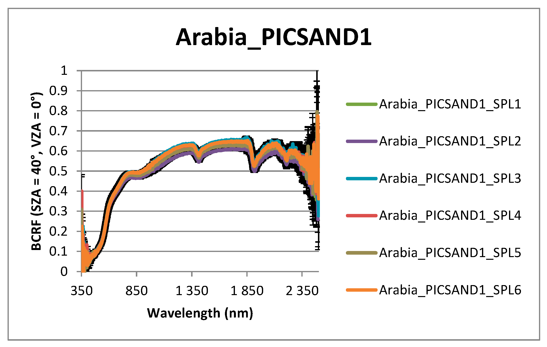
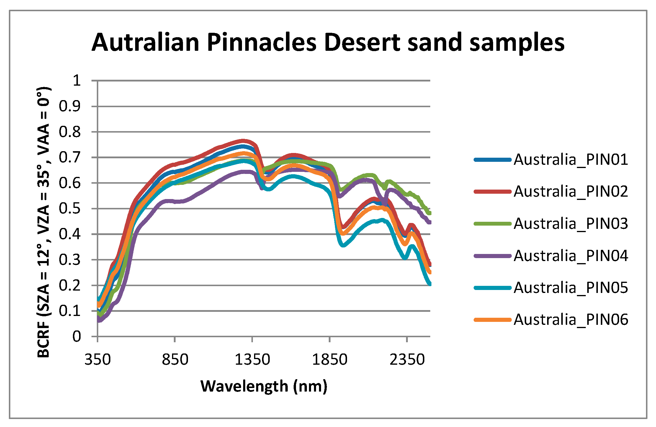
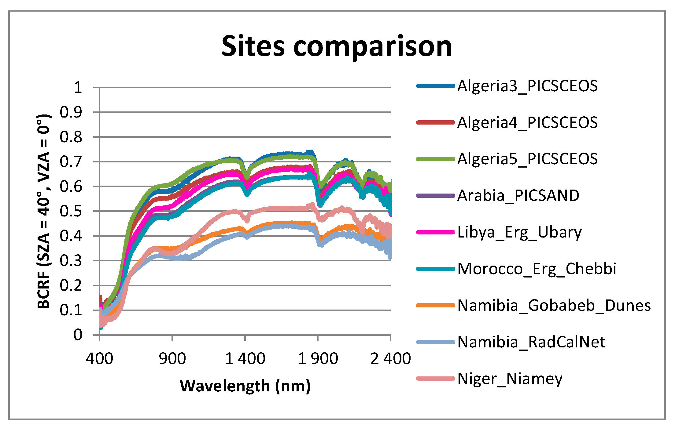
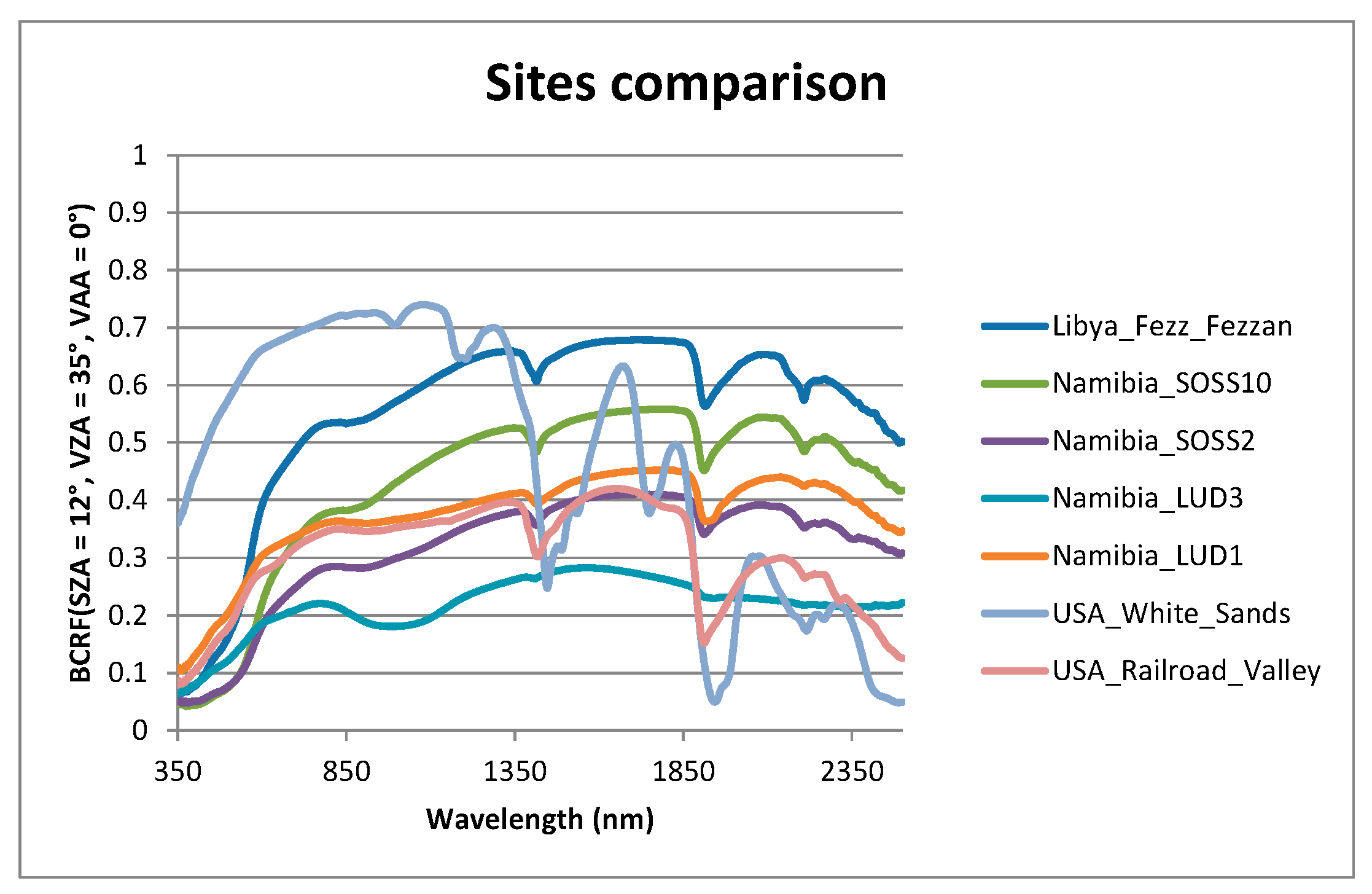

| Incidence (In Blue)\Reflection (In Red) | Directional | Conical | Hemispherical |
|---|---|---|---|
| Directional | 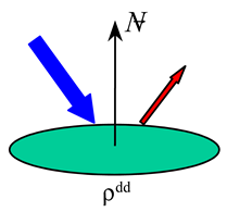 | 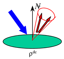 |  |
| Conical | 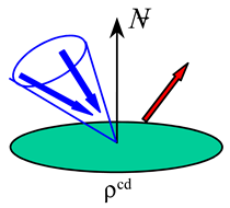 |  |  |
| Hemispherical | 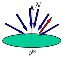 |  | 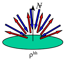 |
| Sample ID | Provider | Latitude/Longitude | Site Nearby | Measurement |
|---|---|---|---|---|
| ONERA_Algeria3_PICSCEOS | ONERA | 29.34 N/7.33 E | Algeria3 | BCRF |
| ONERA_Algeria4_PICSCEOS | ONERA | 29.84 N/5.78 E | Algeria4 | BCRF |
| ONERA-Bristow_Algeria5_PICSCEOS_SPL1 | C. Bristow | 30.5783 N/2.3468 E | Algeria5 | BCRF |
| ONERA-Bristow_Algeria5_PICSCEOS_SPL2 | C. Bristow | 30.5920 N/2.1012 E | Algeria5 | BCRF |
| ONERA-Bristow_Algeria5_PICSCEOS_SPL3 | C. Bristow | 30.7344 N/2.7814 E | Algeria5 | BCRF |
| ONERA-ESA_Arabia_PICSAND1_SPL1 | M. Kheireddine | 29.4823 N/41.1445 E | Arabia_PICSAND1 | BCRF |
| ONERA-ESA_Arabia_PICSAND1_SPL2 | M. Kheireddine | 29.4791 N/41.1401 E | Arabia_PICSAND1 | BCRF |
| ONERA-ESA_Arabia_PICSAND1_SPL3 | M. Kheireddine | 29.4404 N/41.1710 E | Arabia_PICSAND1 | BCRF |
| ONERA-ESA_Arabia_PICSAND1_SPL4 | M. Kheireddine | 29.4403 N/41.1708 E | Arabia_PICSAND1 | BCRF |
| ONERA-ESA_Arabia_PICSAND1_SPL5 | M. Kheireddine | 29.4394 N/41.1700 E | Arabia_PICSAND1 | BCRF |
| ONERA-ESA_Arabia_PICSAND1_SPL6 | M. Kheireddine | 29.33475 N/41.3207 E | Arabia_PICSAND1 | BCRF |
| ONERA-White_Namibia_LUD1 | K. White | -26.6849 N/15.2071 E | Namibia_PICSAND1 | 1 geometry BCRF |
| ONERA-White_Namibia_LUD3 | K. White | −26.7245 N/15.3104 E | Namibia_PICSAND1 | 1 geometry BCRF |
| ONERA-White_Namibia_SOSS2 | K. White | −24.7234 N/15.3174 E | Namibia_PICSAND1 | 1 geometry BCRF |
| ONERA-White_Namibia_SOSS10 | K. White | −24.4578 N/15.7765 E | Namibia_PICSAND1 | 1 geometry BCRF |
| ONERA_Namibia_Gobabeb_Dunes | L. Poutier | −23.5699 N/15.0434 E | BCRF | |
| ONERA-CNES_Namibia_RadCalNet | S. Marq | BCRF | ||
| ONERA-Lau_Australia_PIN01 | I. Lau | −30.5900 N/115.15675 E | 1 geometry BCRF | |
| ONERA-Lau_Australia_PIN02 | I. Lau | −30.5846 N/115.1496 E | 1 geometry BCRF | |
| ONERA-Lau_Australia_PIN03 | I. Lau | −30.5844 N/115.1492 E | 1 geometry BCRF | |
| ONERA-Lau_Australia_PIN04 | I. Lau | −30.5824 N/115.1468 E | 1 geometry BCRF | |
| ONERA-Lau_Australia_PIN05 | I. Lau | −30.5810 N/115.1452 E | 1 geometry BCRF | |
| ONERA-Lau_Australia_PIN06 | I. Lau | −30.5829 N/115.1472 E | 1 geometry BCRF | |
| ONERA-Lau_Australia_Lucky_Bay | I. Lau | −33.9877 N/122.2308 E | 1 geometry BCRF | |
| ONERA-Lau_Australia_Wylie_Bay | I. Lau | −33.8247 N/121.9975 E | 1 geometry BCRF | |
| ONERA-Schaepman_Libya_Erg_Ubari | M. Schaepman | BCRF | ||
| ONERA-Bristow_Libya_Fezzan_Fezz | C. Bristow | 1 geometry BCRF | ||
| ONERA-Bristow_Morocco_Erg_Chebbi | C. Bristow | BCRF | ||
| ONERA_Niger_Niamey | French Defence Forces | BCRF | ||
| ONERA-Thome_USA_Railroad_Valley | K. Thome | 1 geometry BCRF | ||
| ONERA-Thome_USA_White_Sands | K. Thome | 1 geometry BCRF |
| Model Name | Number of Fitting Parameters | Parameter Dependency | Reference |
|---|---|---|---|
| Ross–Li–Maignan | 3 | linear | [17] |
| Roujean | 3 | linear | [18] |
| RPV | 4 | nonlinear | [19] |
| Snyder | 7 | nonlinear | [20] |
| Phases | Weight % | Error (Weight %) |
|---|---|---|
| Quartz | 87 | 3 3 5 3 |
| Potassium feldspar (microcline and orthoses) | 10 | |
| Kaolinite | 2 | |
| Spinel (chromite on the diffractogram) | 1 | |
| Illite and micas | In traces | |
| Ulvospinel | In traces | |
| Plagioclase (albite on the diffractogram) | In traces |
| Sample | Diameter of the Maximum of Grain Size Histogram (µm) |
|---|---|
| ONERA-Thome_USA_Rail_Road_Valley | 50.8 |
| ONERA_Namibia_RadCalNet | 113.8 |
| ONERA_Algeria4_PICSCEOS | 127.7 |
| ONERA-Bristow_Algeria5_PICSCEOS_SPL3 | 143.3 |
| ONERA-White_Namibia_LUD1 | 143.3 |
| ONERA-Thome_USA_White_Sands | 143.3 |
| ONERA-ESA_Arabia_PICSAND1_SPL6 | 160.8 |
| ONERA_Algeria3_PICSCEOS | 180.4 |
| ONERA-White_Namibia_LUD3 | 180.4 |
| ONERA_Namibia_Gobabeb_Dunes | 202.4 |
| ONERA-Lau_Australia_Wylie_Bay | 202.4 |
| ONERA-Bristow_Algeria5_PICSCEOS_SPL1 | 227.1 |
| ONERA-Bristow_Algeria5_PICSCEOS_SPL2 | 227.1 |
| ONERA-ESA_Arabia_PICSAND1_SPL4 | 227.1 |
| ONERA-White_Namibia_SOSS2 | 227.1 |
| ONERA-White_Namibia_SOSS10 | 227.1 |
| ONERA-Bristow_Morocco_Erg_Chebbi | 227.1 |
| ONERA-ESA_Arabia_PICSAND1_SPL1 | 254.8 |
| ONERA-ESA_Arabia_PICSAND1_SPL2 | 254.8 |
| ONERA-ESA_Arabia_PICSAND1_SPL3 | 254.8 |
| ONERA-ESA_Arabia_PICSAND1_SPL5 | 254.8 |
| ONERA_Niger_Niamey | 254.8 |
| ONERA-Lau_Australia_PIN002 | 285.9 |
| ONERA-Schaepman_Libya_Erg_Ubari | 320.8 |
| ONERA-Bristow_Libya_Fezzan_Fezz | 403.8 |
| ONERA-Lau_Australia_PIN005 | 403.8 |
| PI/Reference | Country | Site Characteristics | Meas. Condition | Measured Quantity | Spectral Range (nm) | Directional Range |
|---|---|---|---|---|---|---|
| ONERA [22] | France | Algier/Narbonne | laboratory | BCRF | 520–910 | SZA [0,60] VZA [0–90] (10° step) VAA [0–180] (10° step) |
| Cierniewski-Karnieli [23] | Israel | Negev desert | laboratory | HCRF/BCRF relative to nadir | 450, 550, 650, 850, 1650 | principal plane |
| Coburn [24] | USA | Algodones Dunes | in situ | HCRF/BCRF | 400–900 | SZA [Diurnal set] VZA [0,60] (10° step) and [0,30] (5° step) VAA [0,360] (10° step) |
| Peltoniemi [25,26] | Finland | beach, football, car park | in situ | HCRF/BCRF | 350–2500 | SZA (sun) VZA [0°–62°] VAA [0°–180°] |
| Roosjen [27] | Netherlands | sand, sandy loam | laboratory | BCRF | 350–2499 | SZA [30] Principal plane: VZA [0–65] (5° step); VAA [0–180] (180° step) Other azimuth angles: VZA [0–60] (15° step); VAA [0–180] (30° step). Additional measurements around the hotspot position. |
| Sun [28] | China | Xianjiamu Sumu/3 grain sizes | laboratory | BCRF | 400–2500 | SZA [40,60] VZA [0–60] (10° step) VAA [180–360] (15° step) |
| Zhang/Voss [29] | USA | sand beach + White sands | laboratory | BCRF | 475, 658 | SZA [0,5,15,25,35,45,55,65]; VZA [min 5–max 65] (5–15° step); VAA [min ±5–max ±180] (5–15° step) |
| Zhang [30] | China | Dunhuang site | in situ | BCRF relative to nadir | 399–2386 | SZA [0,60] deg; VZA [0–70] (14° step); relative azimuth angles from 0° to 150° at steps of 30° |
| PI/Reference | Country | Characteristics | Meas. Condition | Measured Quantity | Spectral Domain (nm) |
|---|---|---|---|---|---|
| ASTER [31] | in situ | DHRF | 400–14011 | ||
| USGS [32] | USA | in situ | BCRF | 350–2500 | |
| Hueni [33] | Swiss | sand (bright, coarse, fine, dark) | in situ | BCRF | 350–2500 |
| NPL [10] | Namibia | different soil colors | in situ | BCRF | 380–2500 |
| White, Bullard [34] | USA | Muleshoe Dunes | in situ | BCRF | 400–2500 |
© 2019 by the authors. Licensee MDPI, Basel, Switzerland. This article is an open access article distributed under the terms and conditions of the Creative Commons Attribution (CC BY) license (http://creativecommons.org/licenses/by/4.0/).
Share and Cite
Viallefont-Robinet, F.; Bacour, C.; Bouvet, M.; Kheireddine, M.; Ouhssain, M.; Idoughi, R.; Grignon, L.; Munesa, E.; Lemaître, F.; Rivière, T. Contribution to Sandy Site Characterization: Spectro-Directional Signature, Grain Size Distribution and Mineralogy Extracted from Sand Samples. Remote Sens. 2019, 11, 2446. https://doi.org/10.3390/rs11202446
Viallefont-Robinet F, Bacour C, Bouvet M, Kheireddine M, Ouhssain M, Idoughi R, Grignon L, Munesa E, Lemaître F, Rivière T. Contribution to Sandy Site Characterization: Spectro-Directional Signature, Grain Size Distribution and Mineralogy Extracted from Sand Samples. Remote Sensing. 2019; 11(20):2446. https://doi.org/10.3390/rs11202446
Chicago/Turabian StyleViallefont-Robinet, Françoise, Cédric Bacour, Marc Bouvet, Malika Kheireddine, Mustapha Ouhssain, Ramzi Idoughi, Léo Grignon, Eric Munesa, François Lemaître, and Thomas Rivière. 2019. "Contribution to Sandy Site Characterization: Spectro-Directional Signature, Grain Size Distribution and Mineralogy Extracted from Sand Samples" Remote Sensing 11, no. 20: 2446. https://doi.org/10.3390/rs11202446
APA StyleViallefont-Robinet, F., Bacour, C., Bouvet, M., Kheireddine, M., Ouhssain, M., Idoughi, R., Grignon, L., Munesa, E., Lemaître, F., & Rivière, T. (2019). Contribution to Sandy Site Characterization: Spectro-Directional Signature, Grain Size Distribution and Mineralogy Extracted from Sand Samples. Remote Sensing, 11(20), 2446. https://doi.org/10.3390/rs11202446


