Burn Severity and Post-Fire Land Surface Albedo Relationship in Mediterranean Forest Ecosystems


Abstract
1. Introduction
2. Materials and Methods
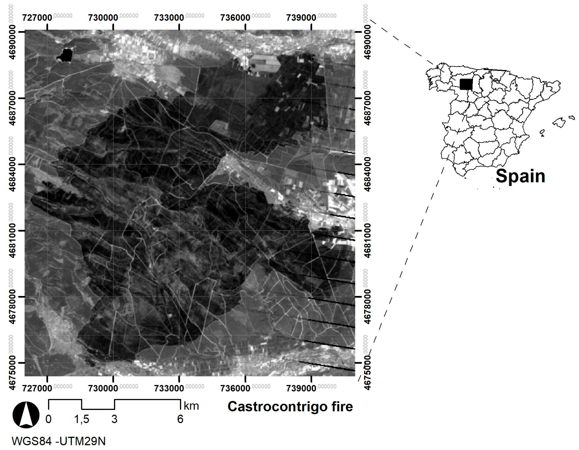
2.1. Materials
2.2. Methods
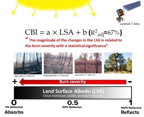
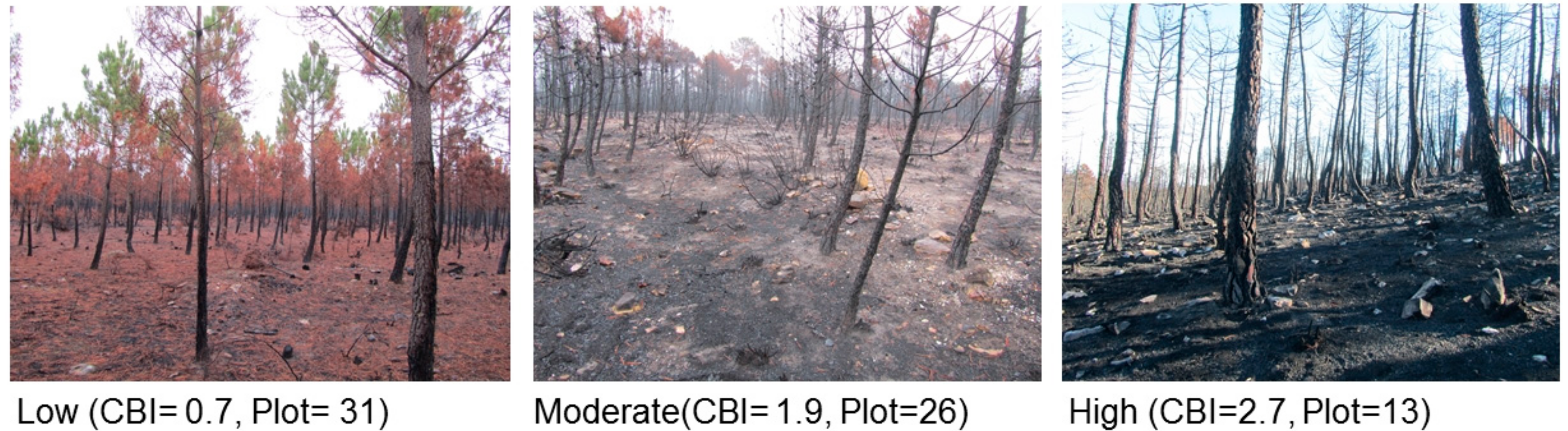
3. Results
4. Discussion
5. Conclusions
Author Contributions
Funding
Acknowledgments
Conflicts of Interest
References
- Bowman, D.M.J.S.; Balch, J.K.; Artaxo, P.; Bond, W.J.; Carlson, J.M.; Cochrane, M.A.; D’Antonio, C.M.; Defries, R.S.; Doyle, J.C.; Harrison, S.P.; et al. Fire in the earth system. Science 2009, 324, 481–548. [Google Scholar] [CrossRef] [PubMed]
- Ichoku, C.; Kahn, R.; Chin, M. Satellite contributions to the quantitative characterization of biomass burning for climate modeling. Atmos. Res. 2012, 111, 1–28. [Google Scholar] [CrossRef]
- Poupkou, A.; Markakis, K.; Liora, N.; Giannaros, T.M.; Zanis, P.; Im, U.; Daskalakis, N.; Myriokefalitakis, S.; Kaiser, J.W.; Melas, D.; et al. A modelling study of the impact of the 2007 Greek forest fires on the gaseous pollutant levels in the Eastern Mediterranean. Atmos. Res. 2014, 2014. 149, 1–17. [Google Scholar] [CrossRef]
- García-Llamas, P.; Suárez-Seoane, S.; Taboada, A.; Marcos, E.; Fernández-Manso, A.; Quintano, C.; Fernández-García, V.; Fernández-Guisuraga, J.M.; Calvo, L. Environmental drivers of fire severity in extreme fire events that affect Mediterranean pine forest ecosystems. Forest Ecol. Manage. 2019, 2019. 433, 24–32. [Google Scholar] [CrossRef]
- Key, C.H.; Benson, N.C. Landscape Assessment: Ground Measure of Severity, the Composite Burn Indexand Remote Sensing of Severity, the Normalized Burn Ratio. In FIREMON Fire Effects Monitoring and Inventory System; Lutes, D.C., Keane, R.E., Caratti, J.F., Key, C.H., Benson, N.C., Sutherland, S., Gangi, L.J., Eds.; Gen. Tech. Rep. RMRS-GTR-164-CD: LA; USDA Forest Service, Rocky Mountain Research Station: Ogden, UT, USA, 2006; pp. 1–51. [Google Scholar]
- Parks, S.A.; Holsinger, L.M.; Koontz, M.J.; Collins, L.; Whitman, E.; Parisien, M.-A.; Loehman, R.A.; Barnes, J.L.; Bourdon, J.-F.; Boucher, J.; et al. Giving Ecological Meaning to Satellite-Derived Fire Severity Metrics across North American Forests. Remote Sens. 2019, 11, 1735. [Google Scholar] [CrossRef]
- Quintano, C.; Fernández-Manso, A.; Calvo, L.; Roberts, D.A. Vegetation and Soil Fire Damage Analysis Based on Species Distribution Modeling Trained with Multispectral Satellite Data. Remote Sens. 2019, 11, 1832. [Google Scholar] [CrossRef]
- Araújo, F.M.D.; Ferreira, L.G. Satellite-based automated burned area detection: A performance assessment of the MODIS MCD45A1 in the Brazilian savanna. Int. J. Appl. Earth Obs. 2015, 36, 94–102. [Google Scholar] [CrossRef]
- Colson, D.; Petropoulos, G.P.; Ferentinos, K.P. Exploring the Potential of Sentinels-1 & 2 of the Copernicus Mission in Support of Rapid and Cost-effective Wildfire Assessment. Int. J. Appl. Earth Obs. 2018, 73, 262–276. [Google Scholar]
- Marcos, B.; Gonçalves, J.; Alcaraz-Segura, D.; Cunha, M.; Honrado, J.P. Improving the detection of wildfire disturbances in space and time based on indicators extracted from MODIS data: a case study in northern Portugal. Int. J. Appl. Earth Obs. 2019, 78, 77–85. [Google Scholar] [CrossRef]
- Arnett, J.T.T.R.; Coops, N.C.; Daniels, L.D.; Falls, R.W. Detecting forest damage after a low-severity fire using remote sensing at multiple scales. Int. J. Appl. Earth Obs. 2015, 35, 239–246. [Google Scholar] [CrossRef]
- Harris, S.; Veraverbeke, S.; Hook., S. Evaluating spectral indices for assessing fire severity in Chaparral scosystems (Southern California) Using MODIS/ASTER (MASTER) Airborne Simulator Data. Remote Sens. 2011, 3, 2403–2419. [Google Scholar] [CrossRef]
- Stambaugh, M.C.; Hammer, L.D.; Godfrey, R. Performance of Burn-Severity Metrics and Classification in Oak Woodlands and Grasslands. Remote Sens. 2015, 7, 10501–10522. [Google Scholar] [CrossRef]
- French, N.; Kasischke, E.; Hall, R.; Murphy, K.; Verbyla, D.; Hoy, E.; Allen, J. Using Landsat data to assess fire and burn severity in the North American boreal forest region: an overview and summary of results. Int. J. Wildland Fire 2008, 17, 443–462. [Google Scholar] [CrossRef]
- He, T.; Liang, S.; Wang, D.; Wu, H.; Yu, Y.; Wang, J. Estimation of surface albedo and directional reflectance from Moderate Resolution Imaging Spectroradiometer (MODIS) observations. Remote Sens. Env. 2012, 119, 286–300. [Google Scholar] [CrossRef]
- Pereira, P.; Jordán, A.; Cerdá, A.; Martín, D. Editorial: The role of ash in fire-affected ecosystems. Catena. 2014. [Google Scholar] [CrossRef]
- Veraverbeke, S.; Verstraeten, W.W.; Lhermitte, S.; van de Kerchove, R.; Goossens, R. Assessment of post-fire changes in land surface temperature and surface albedo, and their relation with fire–burn severity using multitemporal MODIS imagery. Int. J. Wildland Fire. 2012, 21, 243–256. [Google Scholar] [CrossRef]
- Beringer, J.; Hutley, L.; Tapper, N.; Coutts, A.; Kerley, A.; O’Grady, A. Fire impacts on surface heat, moisture and carbon fluxes from a tropical savanna in northern Australia. Int. J. Wildland Fire 2003, 12, 333–340. [Google Scholar] [CrossRef]
- Gatebe, C.K.; Ichoku, C.M.; Poudyal, R.; Román, M.O.; Wilcox, E. Surface albedo darkening from wildfires in northern sub-Saharan Africa. Environ. Res. Lett. 2014, 9, 065003. [Google Scholar] [CrossRef]
- Lyons, E.A.; Jin, Y.; Randerson, J.T. Changes in surface albedo after fire in boreal forest ecosystems of interior Alaska assessed using MODIS satellite observations. J. Geophys. Res. 2008, 113, 1–15. [Google Scholar] [CrossRef]
- Jin, Y.; Randerson, J.T.; Goetz, S.J.; Beck, P.S.A.; Loranty, M.M.; Goulden, M.L. The influence of burn severity on postfire vegetation recovery and albedo change during early sucesión in North American boreal forests. J. Geophys. Res. Biogeosci. 2012. [Google Scholar] [CrossRef]
- Mack, M.C.; Treseder, K.K.; Manies, K.L.; Harden, J.W.; Schuur, E.A.G.; Vogel, J.G.; Randerson, J.T.; Chapin, F.S. Recovery of aboveground plant biomass and productivity after fire in mesic and dry black spruce forests of interior Alaska. Ecosystems 2008, 11, 209–225. [Google Scholar] [CrossRef]
- Schmuck, G.; San-Miguel-Ayanz, J.; Camia, T.; Durrant, T.; Boca, R.; Libertá, G. Forest Fires in Europe, Middle East and North Africa 2012. In Reference Report by the Joint Research Centre of the European Commission; Joint Research Centre of the European Commission: Brussels, Belgium, 2012; p. 118. [Google Scholar]
- Miller, J.D.; Thode, A.E. Quantifying burn severity in a heterogeneous landscape with a relative version of the delta Normalized Burn Ratio (dNBR). Remote Sens. Environ. 2007, 109, 66–80. [Google Scholar] [CrossRef]
- Teillet, P.M.; Guindon, B.; Goodenough, D.G. On the slope-aspect correction of multispectral scanner data. Can. J. Remote Sens. 1982, 8, 84–106. [Google Scholar] [CrossRef]
- Chavez, P.S., Jr. Image-based atmospheric corrections—Revisited and improved. Photogramm. Eng. Remote Sens. 1996, 62, 1025–1036. [Google Scholar]
- Liang, S. Narrowband to broadband conversions of land surface albedo. I Algorithms. Remote Sens. Environ. 2000, 76, 213–238. [Google Scholar] [CrossRef]
- Liang, S.; Shuey, C.J.; Russ, A.L.; Fang, H.; Chen, M.; Walthall, C.L.; Daughtry, C.S.T.; Hunt, R., Jr. Narrowband to broadband conversions of land surface albedo: II. Validation. Remote Sens. Environ. 2002, 84, 25–41. [Google Scholar] [CrossRef]
- Coakley, J.A., Jr. Reflectance and Albedo, Surface. Encyclopedia of the Atmosphere; Holton, J.R., Curry, J.A., Eds.; Academic Press: Cambridge, MA, USA, 2002; pp. 1914–1923. [Google Scholar]
- Loboda, T.V.; French, N.H.F.; Hight-Harf, C.; Jenkins, L.; Miller, M.E. Mapping fire extent and burn severity in Alaskan tussock tundra: An analysis of the spectral response of tundra vegetation to wildland fire. Remote Sens. Environ. 2013, 134, 194–209. [Google Scholar] [CrossRef]
- O’Halloran, T.L.; Law, B.E.; Goulden, M.L.; Wang, Z.; Barr, J.G. Radiative forcing of natural forest disturbances. Glob. Change Biol. 2012, 18, 555–565. [Google Scholar] [CrossRef]
- Chambers, S.D.; Chapin III, F.S. Fire effects on surface atmosphere energy exchange in Alaskan black spruce ecosystems: Implications for feedbacks to regional climate. J. Geophys. Res. 2002, 107, 8145. [Google Scholar] [CrossRef]
- McMillan, A.M.S.; Goulden, M.L. Age-dependent variation in the biophysical properties of boreal forests. Global Biogeochem. Cy. 2008, 22, GB2023. [Google Scholar]
- Franch, B.; Vermote, E.F.; Claverie, M. Intercomparison of Landsat albedo retrieval techniques and evaluation against in situ measurements across the US SURFRAD network. Remote Sens. Environ. 2014, 152, 627–637. [Google Scholar] [CrossRef]
- Calvo, L.; Torres, O.; Valbuena, L.; Luis, E. Recruitment and early growth of Pinus pinaster seedlings over five years after a wildfire in NW Spain. Forest Systems. 2013, 22, 582–586. [Google Scholar] [CrossRef]
- Amiro, B.D.; Orchansky, A.L.; Barr, A.G.; Black, T.A.; Chambers, S.D.; Chapin III, F.S.; Goulden, M.L.; Litvak, M.; Liu, H.P.; McCaughey, J.H.; et al. The effect of postfire stand age on the boreal forest energy balance. Agr. Forest Meteorol. 2006, 140, 41–50. [Google Scholar] [CrossRef]
- Roberts, D.A.; Ustin, S.L.; Ogunjemiyo, S.; Greenberg, J.; Dobrowski, S.Z.; Chen, J.Q.; Hinckley, T.M. Spectral and structural measures of northwest forest vegetation at leaf to landscape scales. Ecosystems 2004, 7, 545–562. [Google Scholar] [CrossRef]
- Fuller, O.D.; Ottke, C. Land cover, rainfall and land-surface albedo in West Africa. Climatic Change 2002, 54, 181–204. [Google Scholar] [CrossRef]
- Cocke, A.E.; Fulé, P.Z.; Crouse, J.E. Comparison of burn severity assessments using Differenced Normalized Burn Ratio and ground data. Int. J. Wildland Fire 2005, 14, 189–198. [Google Scholar] [CrossRef]
- Tanase, M.; de la Riva, J.; Pérez-Cabello, F. Estimating burn severity in Aragón pine forest using optical based indices. Can. J. Forest Res. 2011, 41, 863–872. [Google Scholar] [CrossRef]
- Vieira, D.C.S.; Fernández, C.; Vega, J.A.; Keizer, J.J. Does soil burn severity affect the post-fire runoff and interrill erosion response? A review bases on meta-analysis of field rainfall simulation data. J. Hydrol. 2015, 523, 452–464. [Google Scholar] [CrossRef]
- Vega, J.A.; Fontúrbel, M.T.; Fernández, C.; Arellano, A.; Díaz-Raviña, M.; Carballas, T.; Martín, A.; González-Prieto, S.; Merino, A.; Benito, E. Acciones urgentes contra la erosión en áreas forestales quemadas: Guía para su planificación en Galicia; Andavira, D.L., Ed.; Xunta de Galicia: Santiago de Compostela, Spain, 2013; p. 139. ISBN 978-84-8408-716-8. [Google Scholar]
- Ireland, G.; Petropoulos, G.P. Exploring the relationships between post-fire vegetation regeneration dynamics, topography and burn severity: A case study from the Montane Cordillera Ecozones of Western Canada. Appl. Geogr. 2015, 56, 232–248. [Google Scholar] [CrossRef]
- Chambers, S.D.; Beringer, J.; Randerson, J.T.; Chapin III, F.S. Fire effects on net radiation and energy partitioning: Contrasting responses of tundra and boreal forest ecosystems. J. Geophys. Res. 2005, 110, D09106. [Google Scholar] [CrossRef]
- Miettinen, J. Variability of fire-induced changes in MODIS surface reflectance by land-cover type in Borneo. Int. J. Remote Sens. 2007, 28, 4967–4984. [Google Scholar] [CrossRef]
- Pereira, J.M. Remote sensing of burned areas in tropical savannas. Int. J. Wildland Fire. 2003, 12, 259–270. [Google Scholar] [CrossRef]
- Silva, J.M.N.; Cadima, J.F.C.L.; Pereira, J.M.C.; Grégoire, J.-M. Assessing the feasibility of a global model for multitemporal burned area mapping using SPOT-VEGETATION data. Int. J. Remote Sens. 2004, 25, 4889–4913. [Google Scholar] [CrossRef]


| Burn Severity Levels | LSAshort | LSAvis | LSAvis-diffuse | LSAvis-direct | LSANIR | LSANIR-diffuse | LSANIR-direct | |||||||
|---|---|---|---|---|---|---|---|---|---|---|---|---|---|---|
| μ | HG | μ | HG | μ | HG | μ | HG | μ | HG | Μ | HG | μ | HG | |
| Landsat 7 ETM+. September 6th, 2012 | ||||||||||||||
| Unburned | 0.1041 | a | 0.0458 | a | 0.0409 | a | 0.0475 | a | 0.1633 | a | 0.1656 | a | 0.1645 | a |
| Low | 0.0971 | b | 0.0607 | b | 0.0555 | b | 0.0625 | b | 0.1358 | b | 0.1249 | b | 0.1346 | b |
| Moderate | 0.0838 | c | 0.0535 | b | 0.0490 | b | 0.0550 | b | 0.1159 | c | 0.1054 | c | 0.1132 | c |
| High | 0.0820 | c | 0.0527 | b | 0.0482 | b | 0.0542 | b | 0.1129 | c | 0.1041 | c | 0.1102 | c |
| Landsat 7 ETM+. September 9th, 2013 | ||||||||||||||
| Unburned | 0.1060 | a | 0.0365 | a | 0.0314 | a | 0.0383 | a | 0.1761 | a | 0.1823 | a | 0.1772 | a |
| Low | 0.1280 | b | 0.0667 | b | 0.0598 | b | 0.0692 | b | 0.1935 | a | 0.1820 | a | 0.1958 | a |
| Moderate | 0.1398 | b | 0.0791 | b | 0.0713 | b | 0.0822 | b | 0.2062 | b | 0.1899 | a | 0.2087 | b |
| High | 0.1321 | b | 0.0728 | b | 0.0656 | b | 0.0755 | b | 0.1963 | b | 0.1802 | a | 0.1981 | b |
| LSAshort | LSAvis | LSAvis-diffuse | LSAvis-direct | LSANIR | LSANIR-diffuse | LSANIR-direct | |
|---|---|---|---|---|---|---|---|
| Intercept | 5.3802 | 1.9086 | 1.6805 | 2.0123 | 4.9754 | 4.6587 | 4.8010 |
| Slope | −40.8008 | −1.8548 | 2.9281 | −3.79334 | −25.1403 | −23.8127 | −24.048 |
| Correlation coefficient | −0.7136 | −0.0164 | 0.0244 | −0.0344 | −0.7902 | −0.8207 | −0.7976 |
| R2adj (%) | 50.35 | −1.15 | −1.12 | −1.06 | 62.00 | 66.98 | 63.20 |
| Standard error | 0.7972 | 1.1379 | 1.1377 | 1.1374 | 0.69747 | 0.6502 | 0.6864 |
| Mean absolute error | 0.6723 | 0.9657 | 0.9694 | 0.9632 | 0.5752 | 0.5133 | 0.5625 |
| LSA2010–LSA2012 | LSA2010–LSA2013 | |||||||
|---|---|---|---|---|---|---|---|---|
| Linear regression models (CBI = a× dLSA + b) | ||||||||
| dLSAshort | dLSANIR | dLSAshort | dLSANIR | |||||
| Intercept | 0.9300 | 0.4448 | 1.4154 | 1.6314 | ||||
| Slope | 46.5521 | 28.5414 | −19.2374 | −8.5627 | ||||
| Correlation coefficient | 0.6667 | 0.7811 | −0.4503 | −0.2561 | ||||
| R2adj (%) | 44.45 | 61.09 | 20.27 | 6.56 | ||||
| Standard error | 0.8501 | 0.7114 | 1.0356 | 1.1212 | ||||
| Mean absolute error | 0.7278 | 0.5900 | 0.8715 | 0.9563 | ||||
| Fisher’s least significant difference test for the spectral indices and burn severity levels. | ||||||||
| dLSAshort | dLSANIR | dLSAshort | dLSANIR | |||||
| Burn severity levels | μ | HG | μ | HG | μ | HG | μ | HG |
| Unburned | 0.0040 | a | 0.0121 | a | 0.0053 | a | 0.0020 | a |
| Low | 0.0155 | b | 0.0489 | b | −0.0206 | b | −0.015 | b |
| Moderate | 0.0267 | c | 0.0631 | c | −0.0292 | b | −0.0290 | b |
| High | 0.0245 | c | 0.0606 | c | −0.0266 | b | −0.0219 | b |
© 2019 by the authors. Licensee MDPI, Basel, Switzerland. This article is an open access article distributed under the terms and conditions of the Creative Commons Attribution (CC BY) license (http://creativecommons.org/licenses/by/4.0/).
Share and Cite
Quintano, C.; Fernandez-Manso, A.; Marcos, E.; Calvo, L. Burn Severity and Post-Fire Land Surface Albedo Relationship in Mediterranean Forest Ecosystems. Remote Sens. 2019, 11, 2309. https://doi.org/10.3390/rs11192309
Quintano C, Fernandez-Manso A, Marcos E, Calvo L. Burn Severity and Post-Fire Land Surface Albedo Relationship in Mediterranean Forest Ecosystems. Remote Sensing. 2019; 11(19):2309. https://doi.org/10.3390/rs11192309
Chicago/Turabian StyleQuintano, Carmen, Alfonso Fernandez-Manso, Elena Marcos, and Leonor Calvo. 2019. "Burn Severity and Post-Fire Land Surface Albedo Relationship in Mediterranean Forest Ecosystems" Remote Sensing 11, no. 19: 2309. https://doi.org/10.3390/rs11192309
APA StyleQuintano, C., Fernandez-Manso, A., Marcos, E., & Calvo, L. (2019). Burn Severity and Post-Fire Land Surface Albedo Relationship in Mediterranean Forest Ecosystems. Remote Sensing, 11(19), 2309. https://doi.org/10.3390/rs11192309