1. Introduction
Remote sensing has become increasingly popular in the field of humanitarian action because it is an independent and reliable source of information and allows both a quick response to emergencies and the monitoring of gradual changes [
1]. This is of particular importance when observations in the field area are not possible because of limited budget, legal restrictions, or security reasons [
2,
3,
4]. Observation of specific places from space is not only crucial for decision making involving cases of humanitarian response to natural disasters or emergencies [
5,
6], but it also helps to develop a better general understanding of an area and how trends and temporal dynamics have shaped the spatial patterns of the present [
7,
8]. This temporal aspect is often more valuable than the level of spatial detail of the images alone, as it puts the information into a context and increases the interpretability of the retrieved information [
9].
Institutionalized in the International Charter on Space and Major Disasters, a global collaboration of space agencies and disaster response units provides satellite images and value-added products to relief organizations to assist their operations [
10]. However, other institutions and platforms also make operational use of satellite images for humanitarian assistance, such as UNOSAT (United Nations Institute for Training and Research (UNITAR) Operational Satellite Applications Programme, [
11]), the United Nations Platform for Space-Based Information for Disaster Management and Emergency Response (UN-SPIDER, [
12]), ReliefWeb [
13], and the Copernicus Emergency Management Service (EMS) of the European Space Agency (ESA, [
14]). However, these operational routines rely on scientific innovation and applied research. Many studies address the use of satellite imagery in humanitarian contexts. They range from short-term information needs, such as the retrieval of information on displaced persons and households based on very high-resolution (VHR) optical data [
15,
16,
17,
18], regarding the assessment of natural resources (e.g., firewood, groundwater) [
19,
20], developing long-term observations of environmental impacts [
21,
22,
23,
24,
25], plus the documentation of human rights violations [
26,
27]. Especially in long-term applications, the availability of historical images is essential for humanitarian aid, and monitoring dynamics over long periods not only helps reconstruct ecosystem dynamics in an area, but also allows the development of disaster preparedness strategies, early warning systems, and risk adaptation measures for future events [
28,
29,
30].
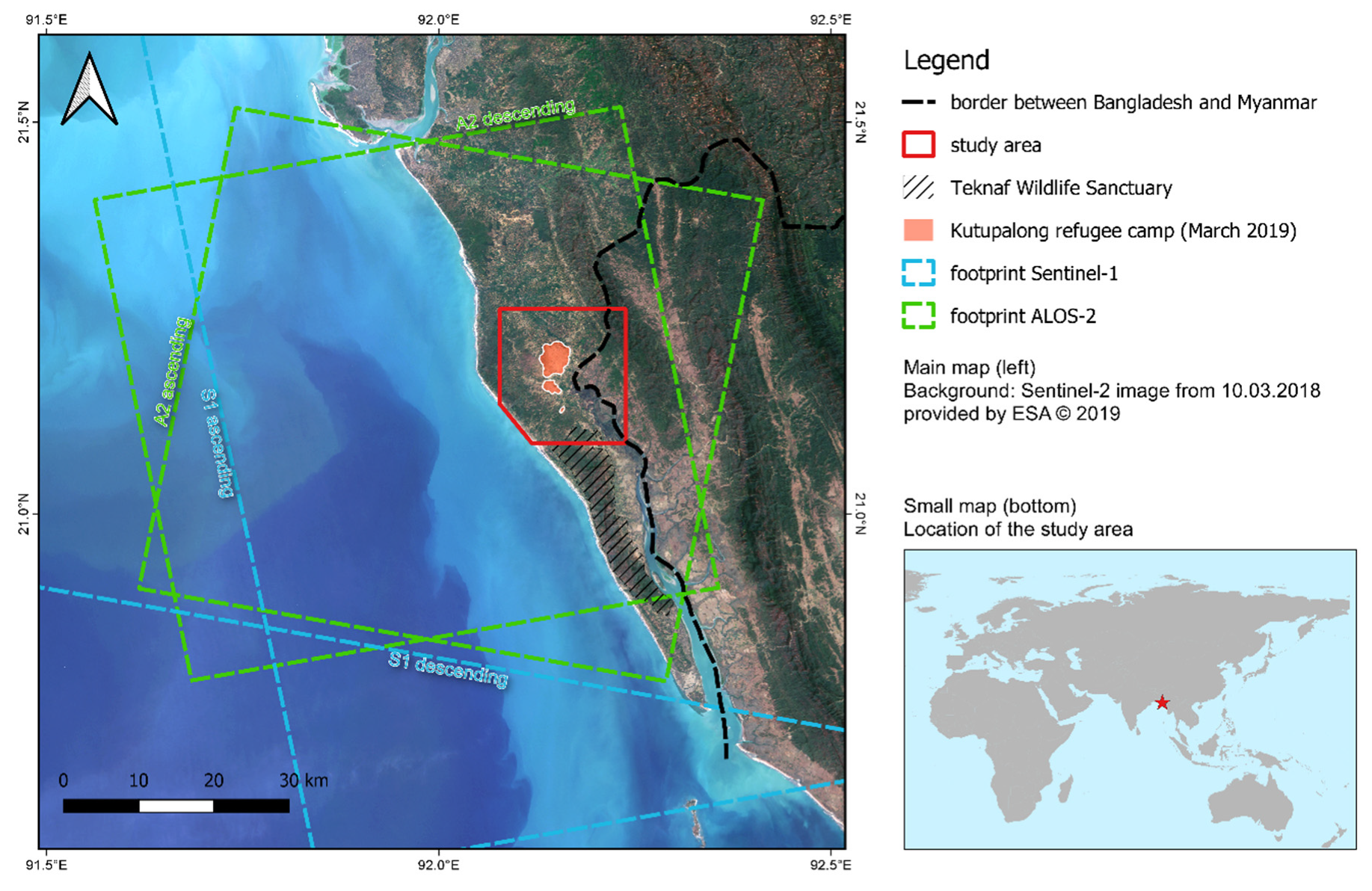
This study uses remote sensing to analyze the land cover changes related to forcibly displaced people in the Cox’s Bazar District of Bangladesh, close to the border of Myanmar (the historical background and a map of the area are provided in
Section 2.1). The large amounts of people arriving since August 2017 (see
Section 2.1) caused the massive expansion of the refugee camp of Kutupalong in 2017 and a considerable loss of forest areas. This case was investigated and documented in various research articles and reports. The most comprehensive and holistic was provided by the United Nations Development Program (UNDP) in 2018 [
31]. It outlines the historical development of the humanitarian crisis and its effects on natural resources, ecosystems, and human health for the whole Cox’s Bazar District. Satellite images of Pléiades were used to qualitatively visualize the landscape changes around camp Kutupalong between 2002, 2009, and 2017. It stated that 1500 of the 26,000 hectares of the Ukhia, Whykong, and Teknaf forests were cleared because of the expansion of the camp. Of this impacted area, 53% were natural forests and 47% were plantations. These numbers are linked to biomass estimations and different forms of fuelwood consumptions based on findings from a study by the Food and Agriculture Organization of the United Nations (FAO), which made use of field measurements and a time-series of eight SPOT images between 1994 and 2016 [
32]. Because fuelwood collection and bamboo use have high social relevance in this area, these points were specifically considered in environmental management and monitoring systems suggested in the UNDP report. Although little is mentioned on the methods of environmental mapping, it pledges for a monitoring of forest areas, growing stock, fragmented areas, areas affected by fire and soil erosion, and population density by means of remote sensing.
A work structure for an environmental impact assessment for the area was proposed by Honeth et al. [
33] who suggest a classification system to quantify the magnitude of the impact for the infrastructures, food and water security, health, social issues, and land use sectors. They also underline the demand for energy as a severe threat to the forest areas and assume a minimum of 600 hectares cleared per month. Without monitoring and resource management, they expect a drastic loss of livelihood and an increased vulnerability to natural hazards.
Both reports highlight the demand for a consistent and continuous monitoring of forest areas, as field surveys are expensive and are often influenced by the subjectivity of the data collectors. To tackle this issue, remote sensing-based studies of this area were conducted, which are introduced in the following section. Imtiaz [
34] employed products of Landsat 8 to quantify the loss of forest areas in the Teknaf sub-district based on the thresholding of the Normalized Difference Vegetation Index (NDVI). Images acquired in December of four consecutive years (2014–2017) were used to minimize the effect of seasonal variations regarding vegetation cover. The study showed a total loss of vegetation cover of 1284 hectares for the entire Teknaf sub-district, and a decrease of 102 hectares in the Teknaf Wildlife Sanctuary for the period of the incident (2016 to 2017), while the changes between 2014 and 2016 were widely negligible. By using the NDVI as an indicator for vegetation cover and a fixed threshold of 0.1 over which a pixel was considered vegetation, the study design is transparent and reproducible. However, no map on the spatial differentiation of changes is included and no accuracy assessment was conducted to estimate the quality of the results.
Labib et al. [
35] compared images of Landsat 7 from March 2017 and December 2017 to investigate the decrease of forest area as a consequence of the extension of the camp. They derived brightness and greenness products and conducted a change vector analysis (CVA) between the two dates to extract the magnitude and direction of change between the three classes of water, forest, and no-forest. They calculated an area of 573 hectares for the transition between forest and camp, accounting for around 11% of the study area. The spatial implications of the changes are presented in a map, but the impact of seasonal variations on the result cannot be determined. Again, the methods are described in a transparent way, but no accuracy assessment is conducted.
A more comprehensive study, provided by Hassan et al. [
23], compared two Sentinel-2 images of December 2016 (pre-influx) and December 2017 (post-influx) in a post-classification change detection approach. They classified the whole Teknaf sub-district into forest, camp, non-forest, and water bodies based on a random forest classifier to conduct an independent accuracy assessment based on field validation campaigns and a very high-resolution (VHR) QuickBird image, resulting in overall accuracies of 95% for both dates. Their reference data were collected during a field campaign in December 2017 to increase the independence of the validation. The study reported an increase of the camp area of Kutupalong–Balukhali of 1219 hectares and a forest loss of 2283 hectares for the investigated period. However, persistent cloud cover prevented them from using images during the rainy season to put their findings into a phenological context. Nonetheless, they highlight the importance of seasonal variations based on a comparison of NDVI between February 2017 and December 2017 along two buffered transects in the study area. The study concludes with a discussion on the environmental and socio-economic implications of the observed landscape changes.
All mentioned studies applied classical pixel-based techniques, which are often considered insufficient for the analysis of complex ecosystems because the spatial resolution of the sensor dictates the scale at which phenomena are described [
36]. This was already declared by Woodcock and Strahler [
37], who described how scale impacts the results of digital image analysis and that every environment has to be analyzed in a suitable spatial resolution. It also becomes evident in these studies that the NDVI is not always a suitable proxy for vegetation cover for various reasons: Firstly, indices and their relationship with biophysical parameters were observed to be highly scale-dependent [
38,
39]. This can especially become a problem when images of multiple sensors with different spatial and spectral resolutions are compared within a multi-temporal approach [
40]. Secondly, there is an impact of soil reflectance which distorts the measure of green vegetation as anticipated by the NDVI [
41]. For example, Todd et al. reported that targets with moist soil background showed higher NDVI values than dry targets with the same vegetation properties [
42]. Especially in areas with pronounced seasonality where the green canopy cover changes during the year, such as Bangladesh in this case, measures that are more independent from spatial resolution and humidity have to be found.
Besides these spectral limitations, all studies name cloud cover as one main constraint in terms of data availability. The impacts of cloud cover and seasonal land cover variations on forest change detection are also widely discussed in various other studies [
8,
43,
44,
45]. For this reason, synthetic aperture radar (SAR) becomes an alternative for monitoring the environment, as it employs microwaves which are largely independent from cloud cover or daylight, and thus valid images that can be utilized for multi-temporal approaches are potentially available over the whole year and at more regular intervals. The potential of SAR for humanitarian action was initially acknowledged by Wegmüller et al. [
46], who mentioned the quick mapping of land cover and hazards as useful applications in this domain. Besides the penetration of cloud cover, they name acquisition costs and the increased information content as the main advantages of radar images. Amitrano et al. [
47] also discuss the capabilities of multi-temporal radar analyses for humanitarian action and present short case studies on land cover mapping, crop monitoring, seasonal water body mapping, and the derivation of digital elevation models with radar interferometry. The first environmental impact assessments were provided by Braun et al., who used time-series of radar data to assess the long-term changes of ecosystems around the refugee camps Dagahaley in Kenya [
48] and Djabal in Chad [
49]. Their studies underline the increased information content of microwave images for the detection of ecosystem changes and discuss how using multi-temporal data reduces the bias of seasonal variabilities which often superimpose gradual long-term changes [
50,
51]. While most SAR sensors make use of either horizontal or vertical waves to measure the backscatter intensity of a surface, polarimetric radar systems send and retrieve signals both horizontally and vertically. This allows for the ability to determine the contribution of different scattering mechanisms to the measured signal, which mainly consists of surface, dihedral, and volume scattering [
52]. This form of signal decomposition allows for the ability to distinguish different types of land cover within a single radar image [
53]; however, only a few polarimetric SAR satellites are operational at the moment [
54].
This study provides a new method of change detection in the context of anthropogenic influence of displaced people as the main factor and addresses the following challenges which were identified above: (1) to develop a framework based on radar images which is independent from cloud cover, (2) to maintain objectivity at the selection of reference areas even when field surveys are not possible because of limited budget and/or security concerns, (3) to perform a multi-scale approach to reduce the scale-dependency of the generated change detection, and (4) to make use of polarimetric information for better classification accuracies via the combination of two SAR sensors of different wavelength and polarization. It furthermore reveals which wavelengths, polarimetric features, and spatial resolutions are most suitable to describe landscape changes at the local to regional scale.
The findings of this work are relevant with respect to the Forest Policy and the 20 year Forestry Sector Master Plan approved by the government of Bangladesh in the 1990s that aim at a national forest cover rate of 20% [
55]. This work can furthermore assist larger monitoring frameworks on the impact of refugee camps on their environments, such as the Social and Environmental Screening Procedure developed by the United Nations Development Programme (UNDP, [
56]). It was conducted in the study area by UNDP and the Ministry of Environment and Forest (MoEF) of Bangladesh to assess both the potential and probability of risks threatening the local population and their social, economic, and environmental implications in the Cox’s Bazar district [
31]. Monitoring land cover change is furthermore relevant in accordance with the Bangladesh Environmental Conservation Act 1995 (ECA, [
57]) and the Wildlife Preservation and Security Act 2012, both which protect the Teknaf wildlife sanctuary that is part of the study area [
58]. On an international level, the Climate Resilient Ecosystems and Livelihoods project (CREL [
59]) aims to improve the livelihood and environment in Bangladesh by improved governance of natural resources and social forest management [
60]. All mentioned legal regulations and research programs underline the demand for a reliable and consistent monitoring framework of forest resources in the study area.
Currently available datasets on forest cover provide global maps, but at annual rates with no consideration of seasonality, such as the ALOS forest/non-forest maps (provided by the Japan Aerospace Exploration Agency (JAXA) [
61]). Others provide more detailed classifications, but at low spatial resolutions, such as land cover products derived from MODIS (provided by NASA, 500 m [
62]) or PROBA-V (provided by CCI/ESA [
63]). None of them are sufficient to capture the dynamics of forest covers within the investigated period.
4. Conclusions and Outlook
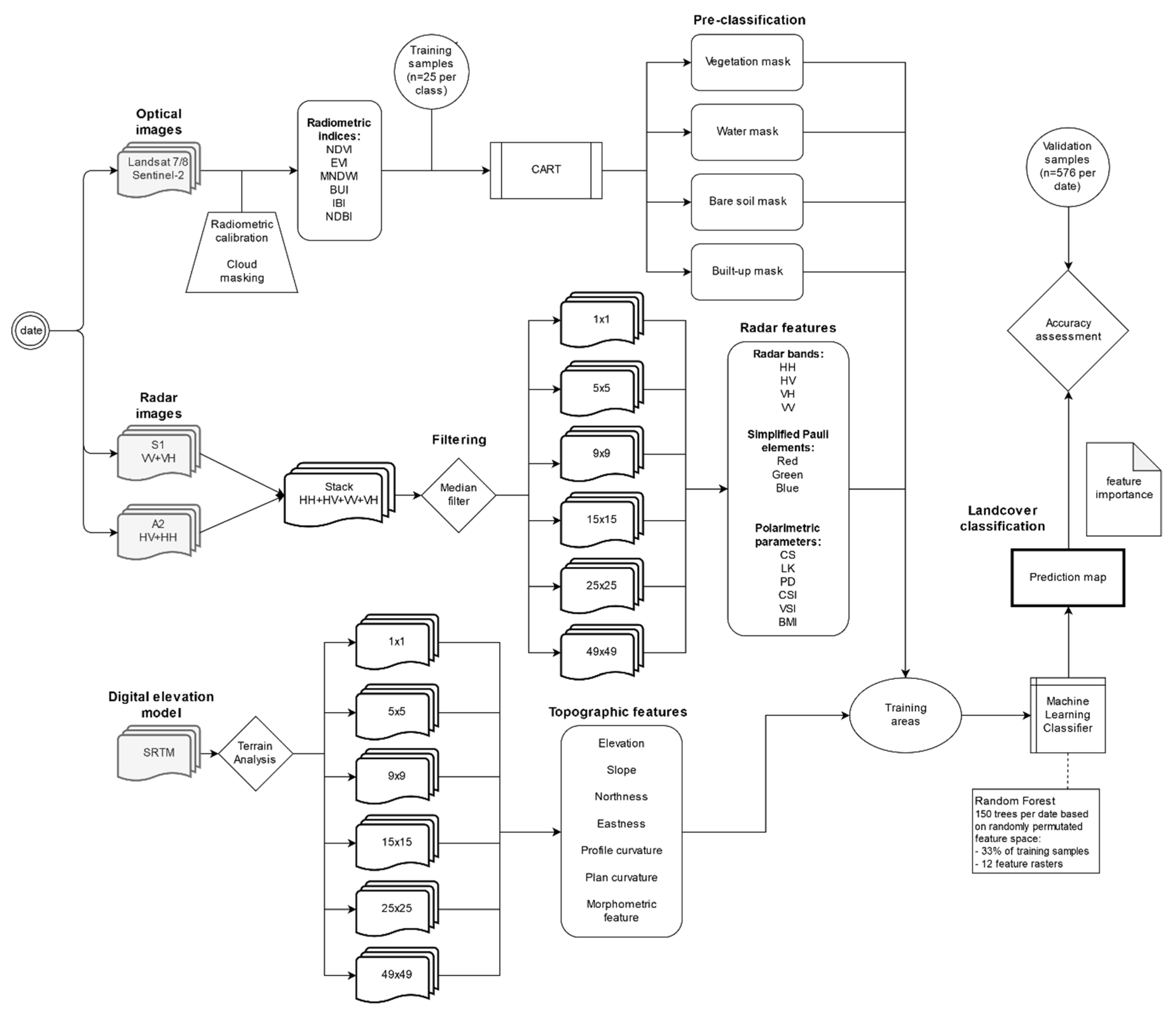
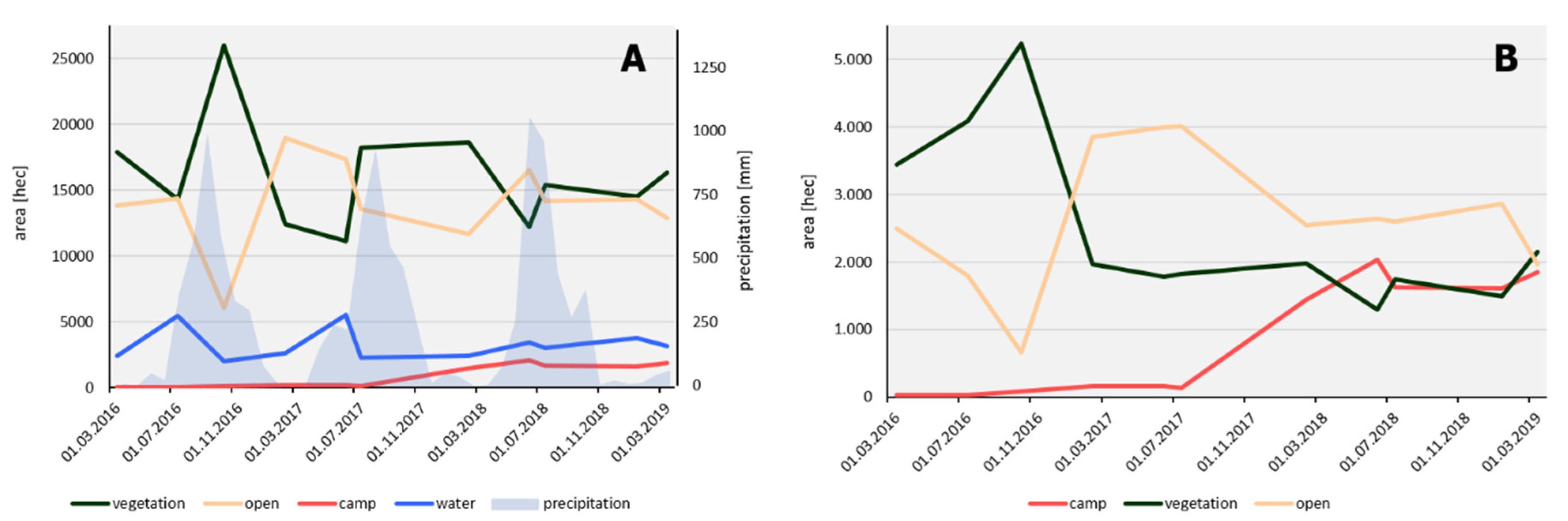
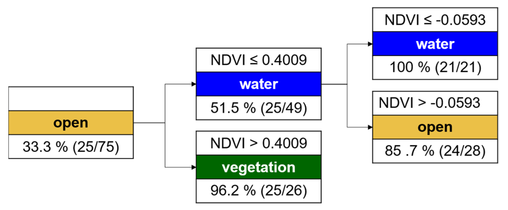
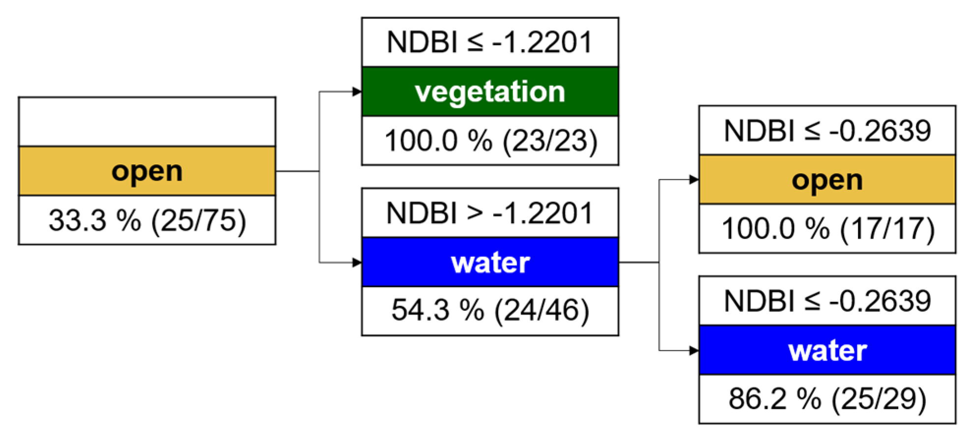
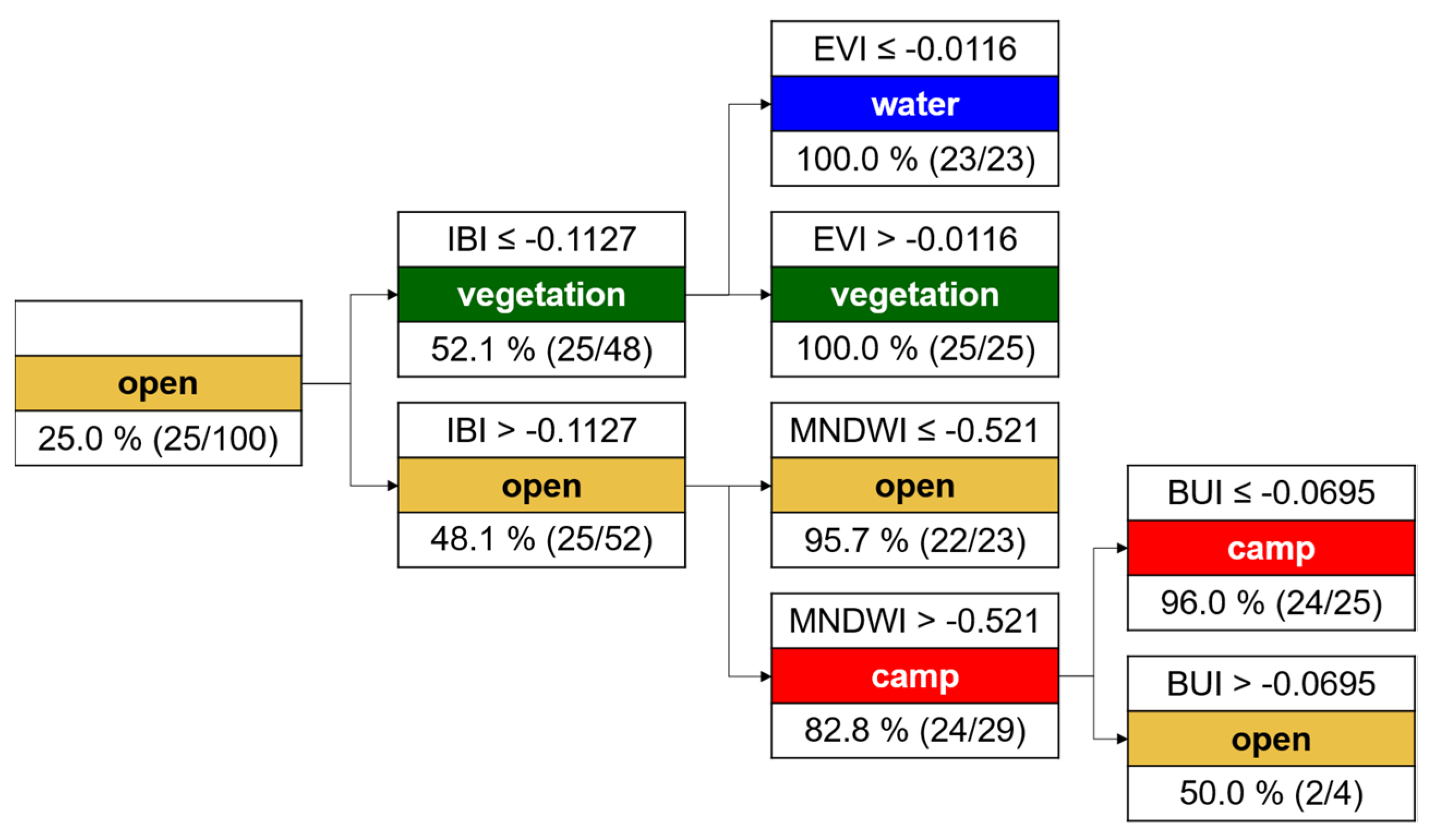
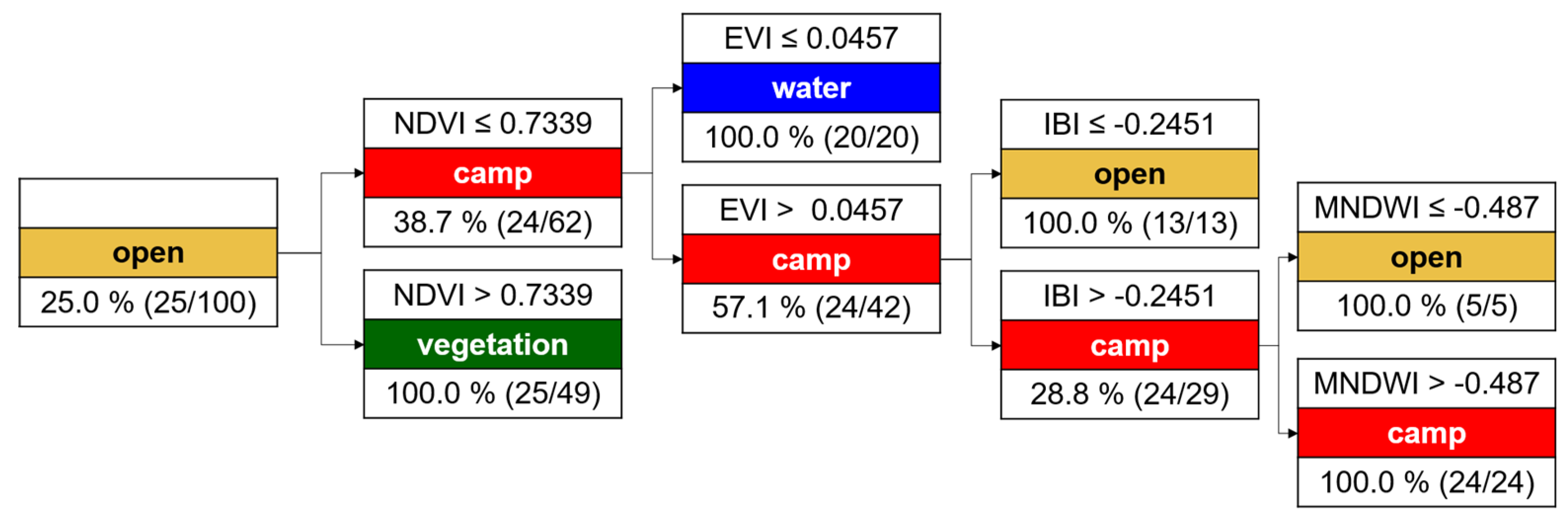
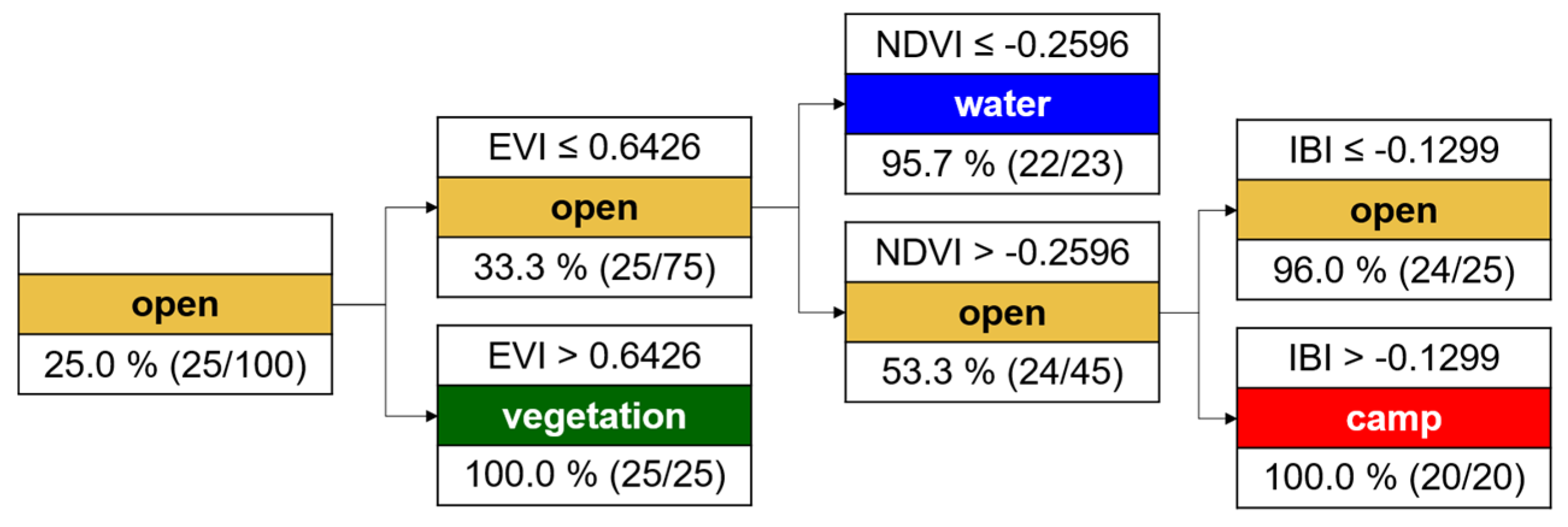
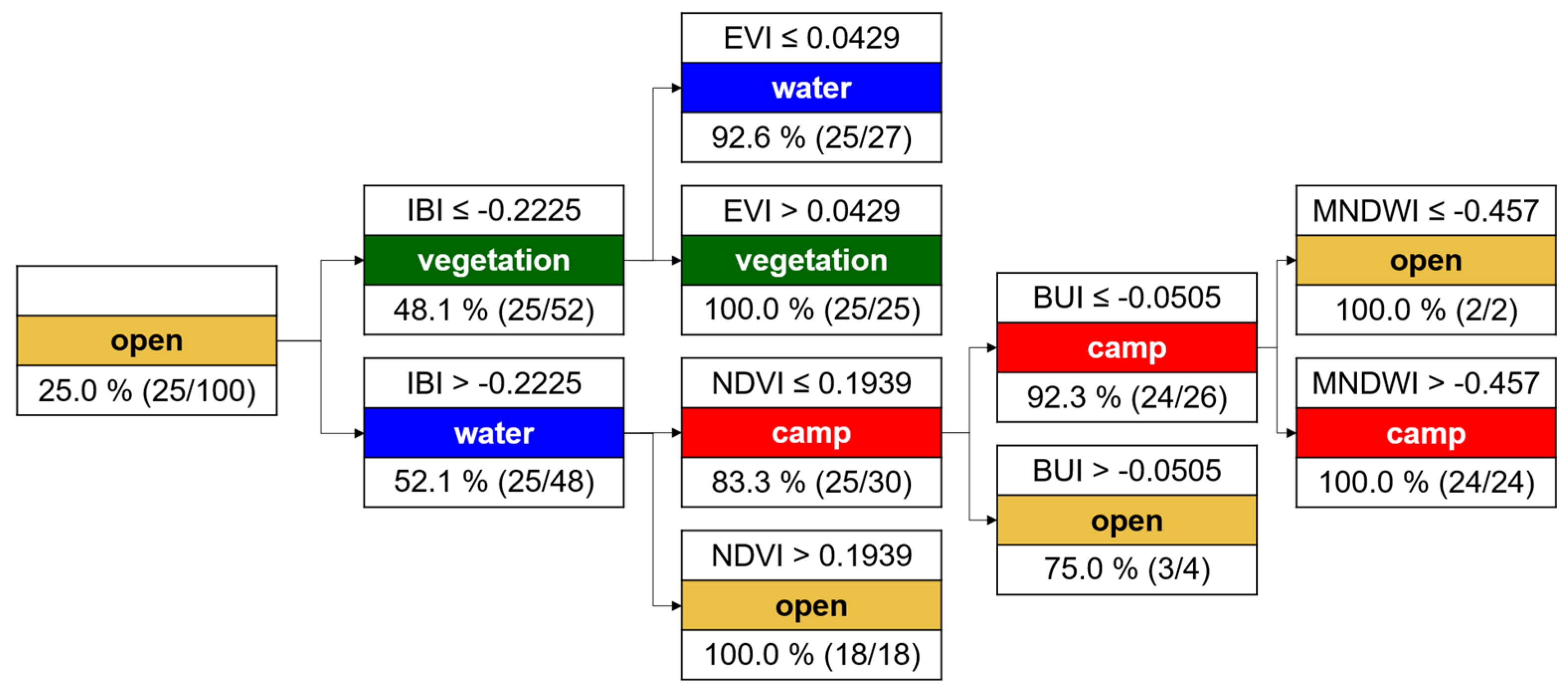
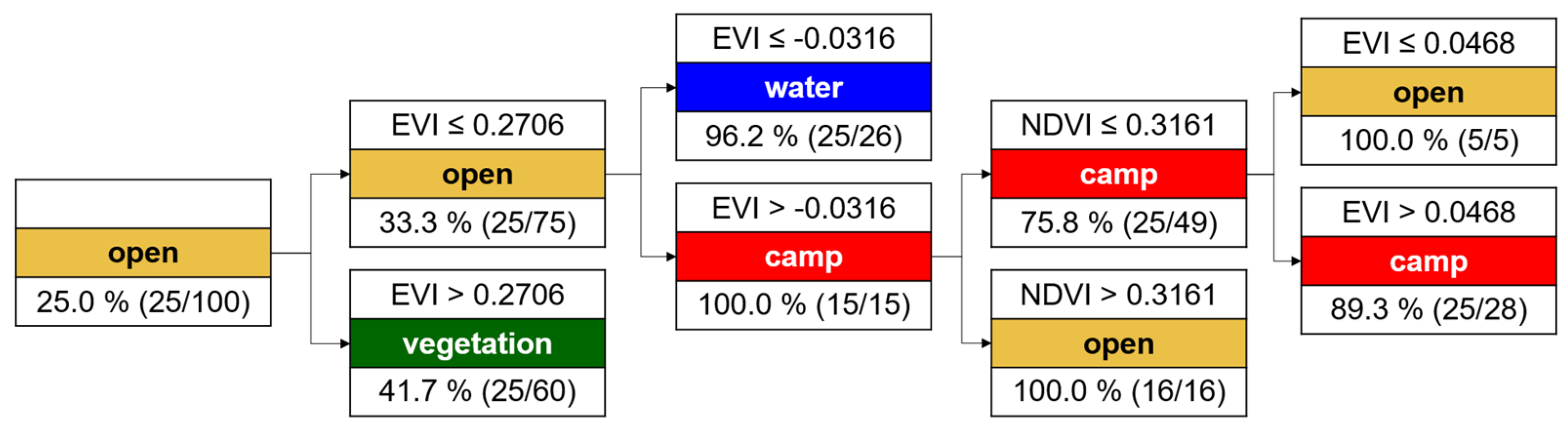
This study showed how radar data of different frequencies can be integrated for land cover assessments and the monitoring of environmental conditions in situations of humanitarian crisis. It complements existing studies that, because of the limited availability of optical data, only roughly estimate the decrease of forests and the growth of camps. This study also introduces a high level of automation, as user input is only needed at the beginning for the selection of a few representative reference samples. As demonstrated in this study, a land cover classification with accuracies above 90% can be achieved by the selection of only 25 sample points per class. This number was proven to be a good trade-off between scientific accuracy and transparency, but also applicability and reproducibility. Applying radiometric indices on optical data to construct simple CARTS was used to identify all areas which fulfil similar criteria and therefore were suitable for training the classifier, even if the optical data were obscured by clouds, gaps, or did not fully cover the area of interest. Especially in cases of emergencies, this brings enormous benefits, as the workflow can be transparently transferred and automatically applied to other data sources or different areas. The only decision to be made by the users is the selection of target classes and the identification of a small amount of representative training areas. It is yet to be tested if other settings, for example, those based on different sensor combinations or located within other ecosystems, in achieving the same level of accuracy as observed in this study.
The use of microwaves additionally increased the quality of the land cover assessments, as they allowed a higher number of input images, especially in the rainy seasons. This helps to consider phenologic variations of the images and reduces their potential bias impacting the results as the images are analyzed as parts of a time series instead of a simple pre- and post-event change detection based on a single image pair. The benefit of time-series analyses over simple binary approaches has been demonstrated in numerous studies and should therefore also be integrated into monitoring frameworks of the humanitarian domain [
7,
47,
135,
136,
137]. Furthermore, radar images can increase the quality of land cover classifications because they measure physical surface characteristics instead of spectral reflectance. This makes them especially valuable in areas of high vegetation cover where higher vegetation and grasslands have similar spectral characteristics. Among other features, this was accomplished by the computation of combined indices (CI) based on polarizations of both sensors. Although they were not based on the complex information of fully-polarimetric imagery, their role for the classification of vegetation and camp areas was demonstrated by their high feature importance—vegetation was found to be characterized best by the Volume Scattering Index (VSI) and the Radar Forest Degradation Index (RFDI), and the combined index 2 (CI2) seemed to be more sensitive towards the volumes and complex structures of crowns. In turn, the combined index 1 (CI) element was found to play a large role for the determination of camp areas where horizontal objects caused higher direct backscatter intensity (
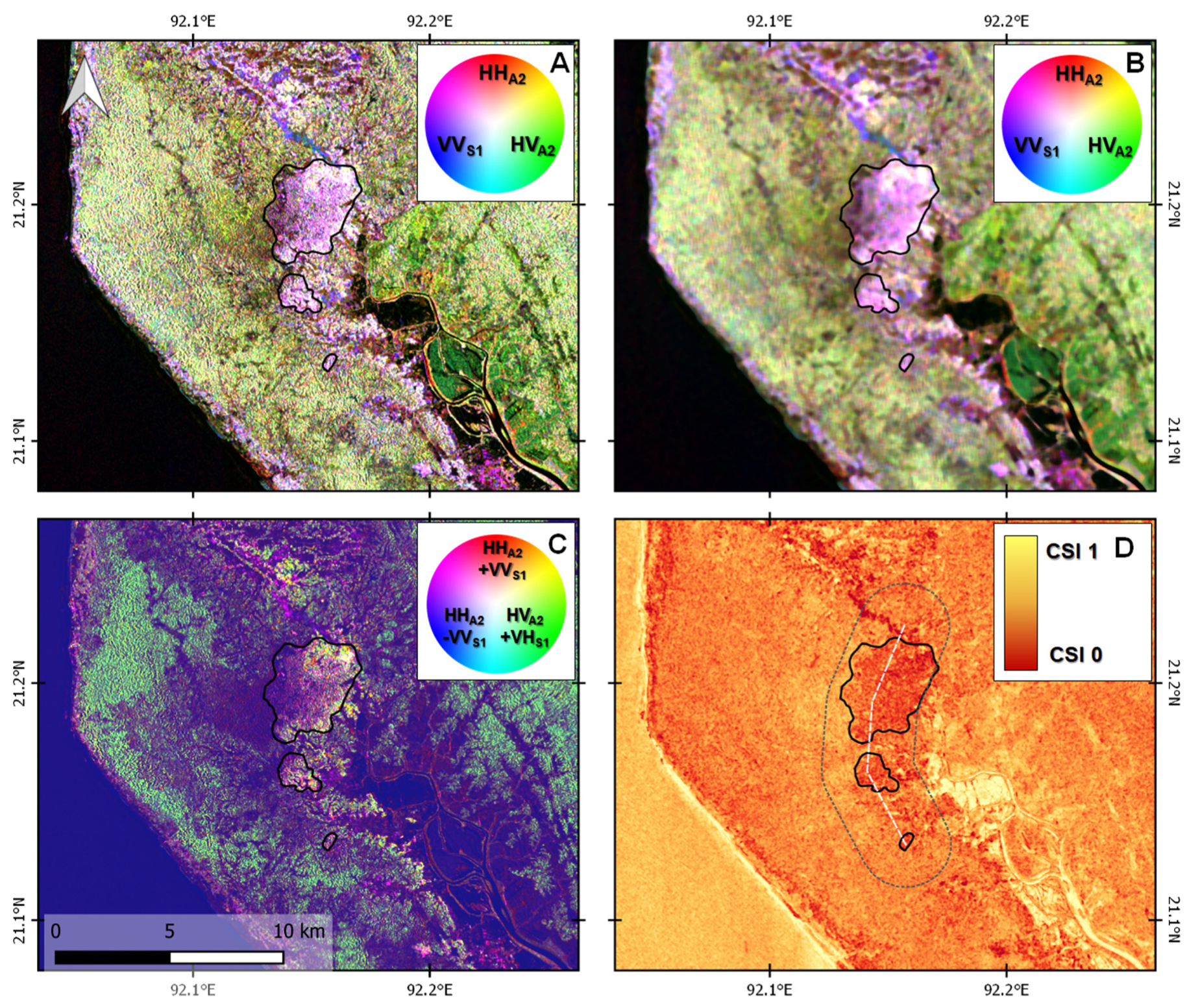
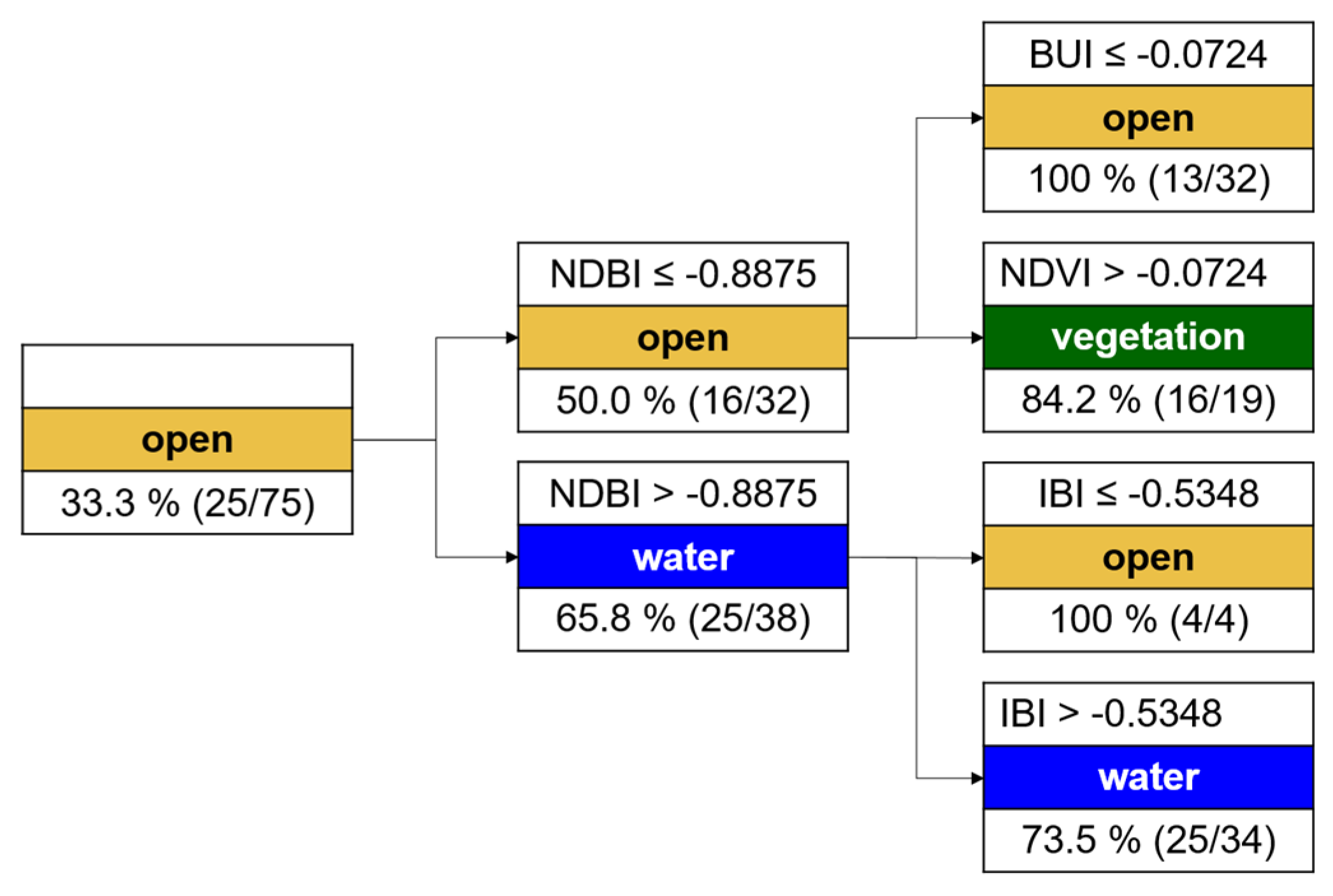
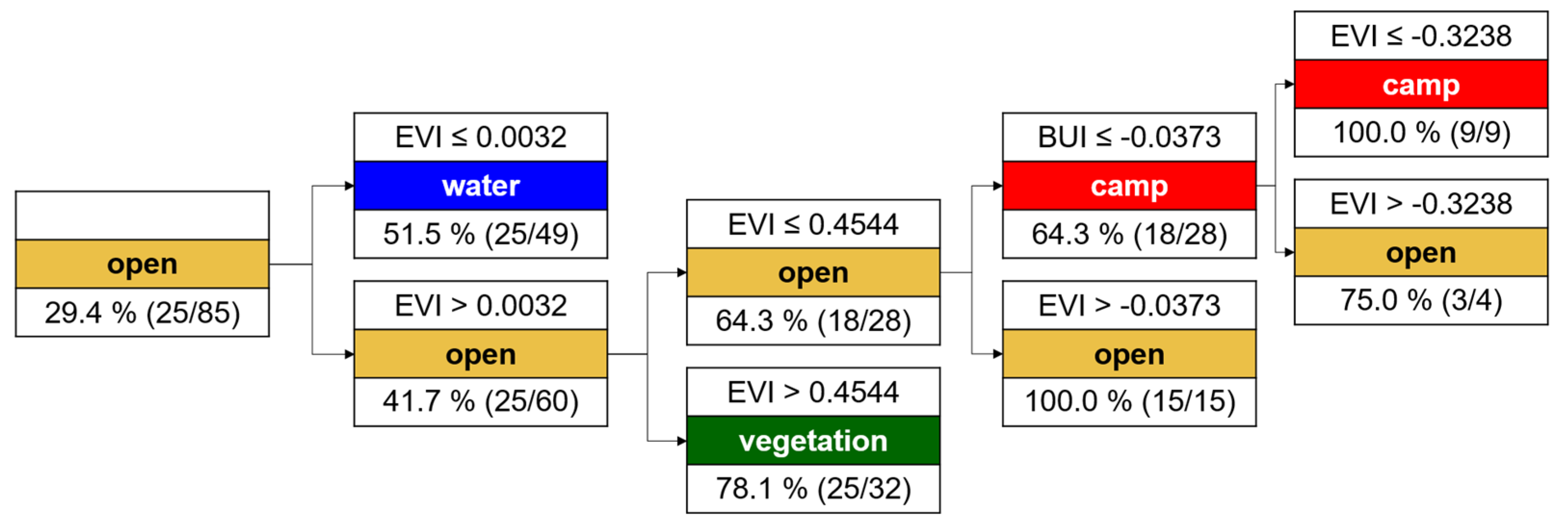
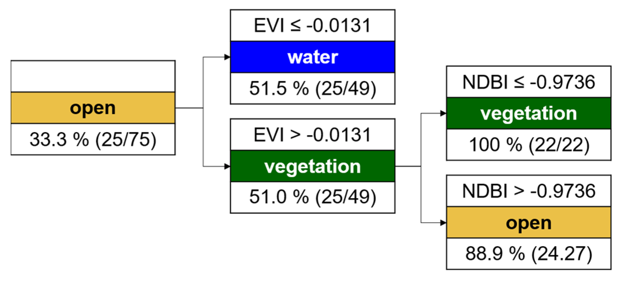
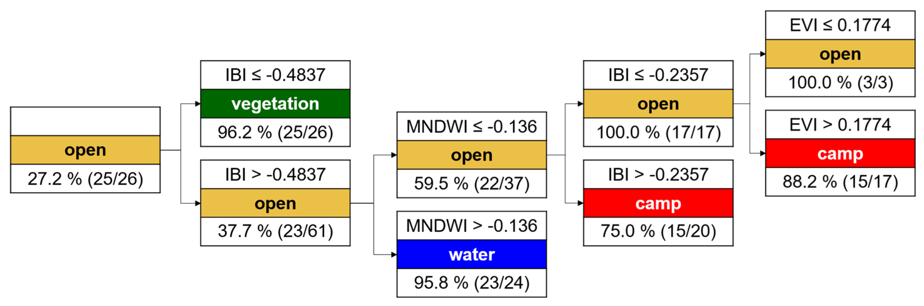
Table 5).
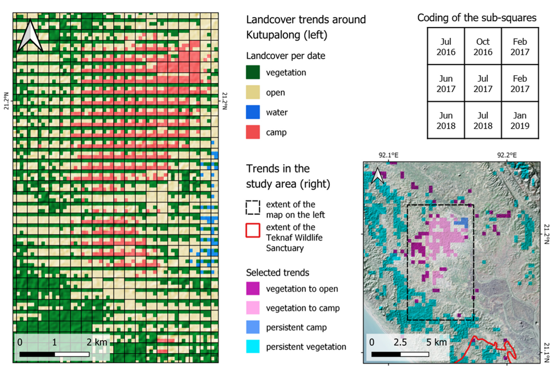
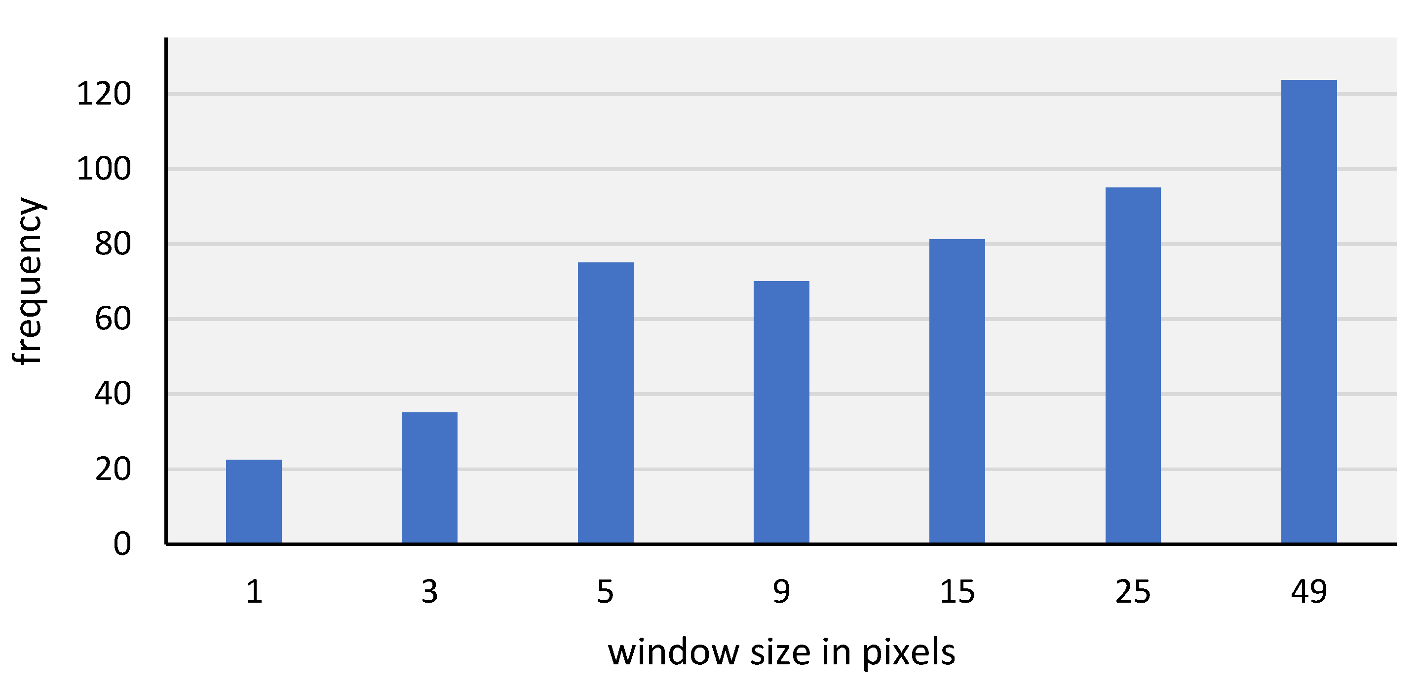
The study also showed that topography played a role in the identification of classes, especially in cases where large areas were covered by homogenous classes, such as water bodies and large evergreen forest areas. Topographic features turned out to be of largest information content when retrieved at large window sizes of 25 or 49 pixels, which correspond to distances of 250 to 500 m. It appeared that these were spatial scales that represented the connection between land cover and landforms best. This was underlined by the fact that 16% of the highest features were DEM-based, and were also slope and aspect features. However, these factors were constant throughout all analyzed dates and therefore only contributed to certain areas, while the seasonal variations were highlighted by changes in backscatter intensities and its derivations.
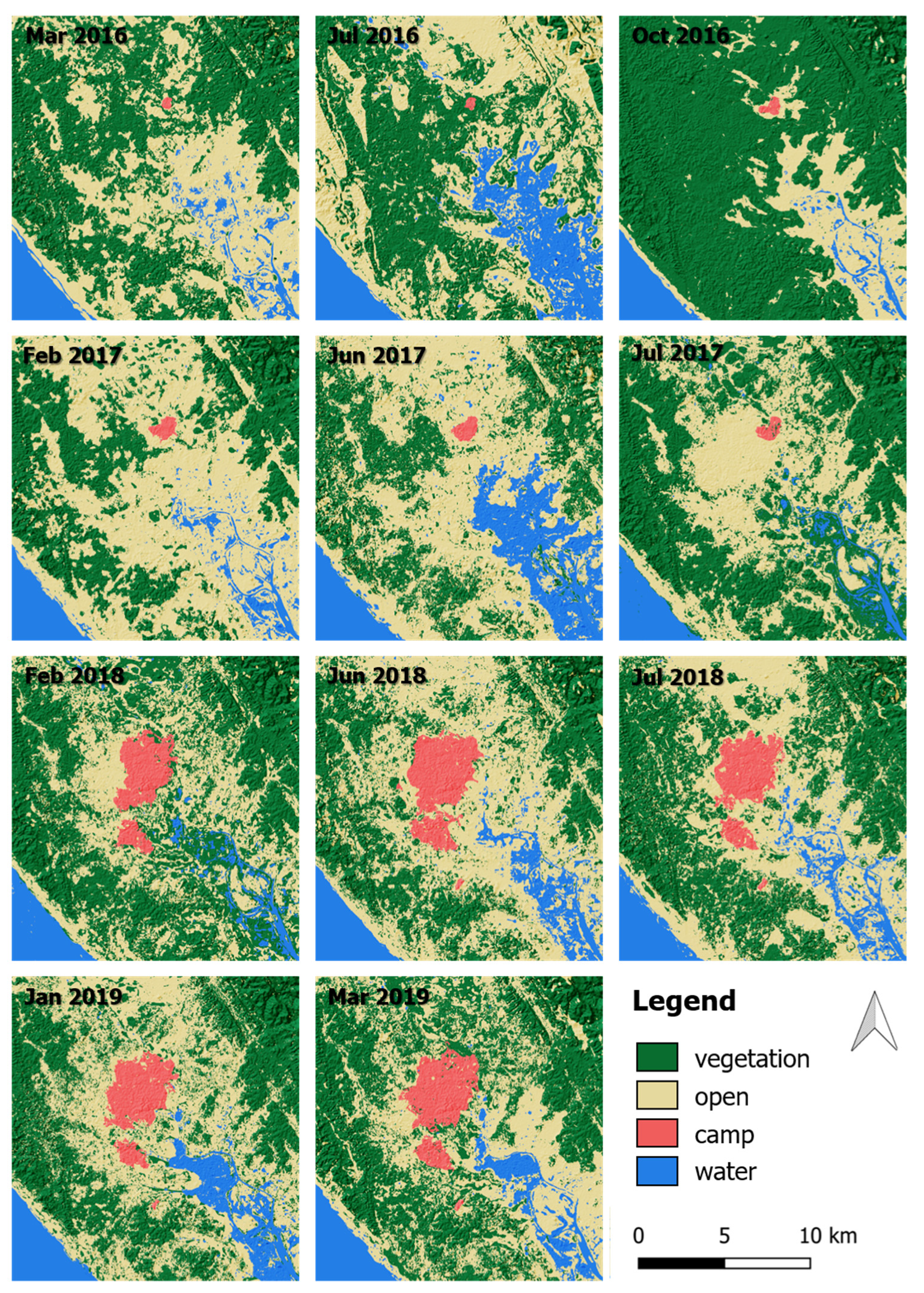
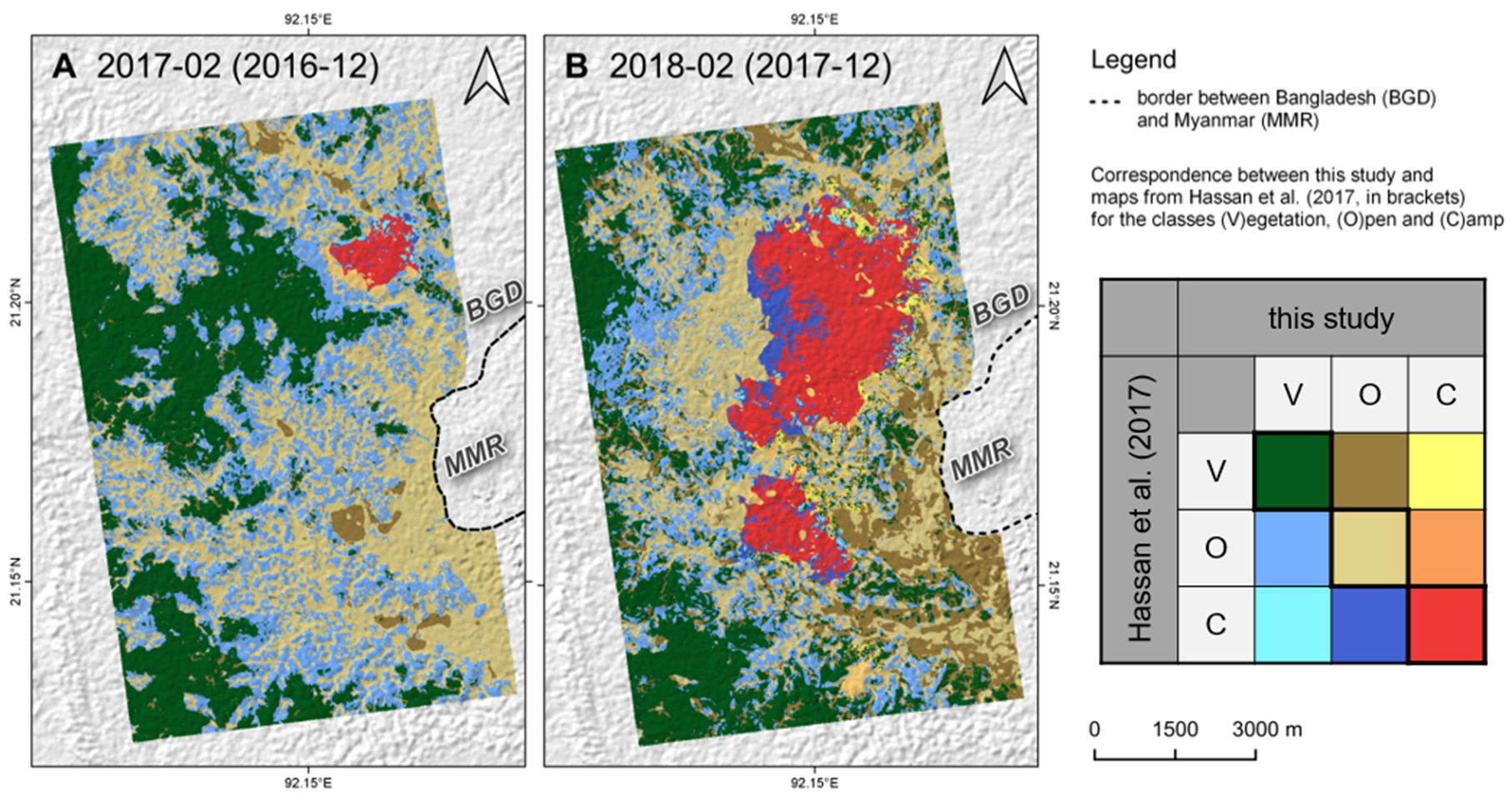
All classified dates showed high classification accuracies, especially for water and camp areas. A comparison with a reference study [
23] showed that the camp areas might have been slightly under-estimated at the edges of the expansion areas where the dwelling density is low. This, as well as the high impact of seasonal variations, has to be considered when land cover maps are evaluated for the monitoring of camp expansion and forest degradation. Furthermore, the benefit of a higher amount of input images became evident here. Although the temporal difference between optical images used for the selection of training areas and the radar images used for classification was kept small, this delay potentially introduces errors in the training step initially, which significantly reduces the quality of the later classification. In an ideal case, optical and radar images are acquired at the same date. With the increasing availability of both radar (e.g., the upcoming Radarsat constellation mission [
138] plus many of the planned SmallSAT missions [
139]) and multi-spectral sensors (e.g., Planet Scope [
140]), this will be more likely in the near future. Nonetheless, a minimum number of image pairs over the investigated period is required, as well as a budget to cover the acquisition costs of commercial satellite data.
Of course, the high classification accuracies are also a product of a low number of target classes. In this study, a discrimination of vegetation, open, camp, and water was sufficient, but in ecosystems with more complex land cover or different seasonal dynamics, a higher number of target classes (e.g., grassland, shrubs, but also solid urban areas vs. camp dwellings of light construction materials) should be considered. The limits regarding the number of classes and usable image pairs over a longer period are to be tested in further studies.
In a humanitarian context, the integration of SAR data not only gives higher flexibility regarding the number of images and the definition of suitable acquisition dates, but also allows for the identification of landcover types which are related to characteristics of surfaces (size, form, roughness, material, and scattering mechanisms). This makes them a valuable source of information for future emergencies, given that enough studies exist that demonstrate their applicability and transferability. More research is needed to investigate the benefits of radar data in humanitarian settings.
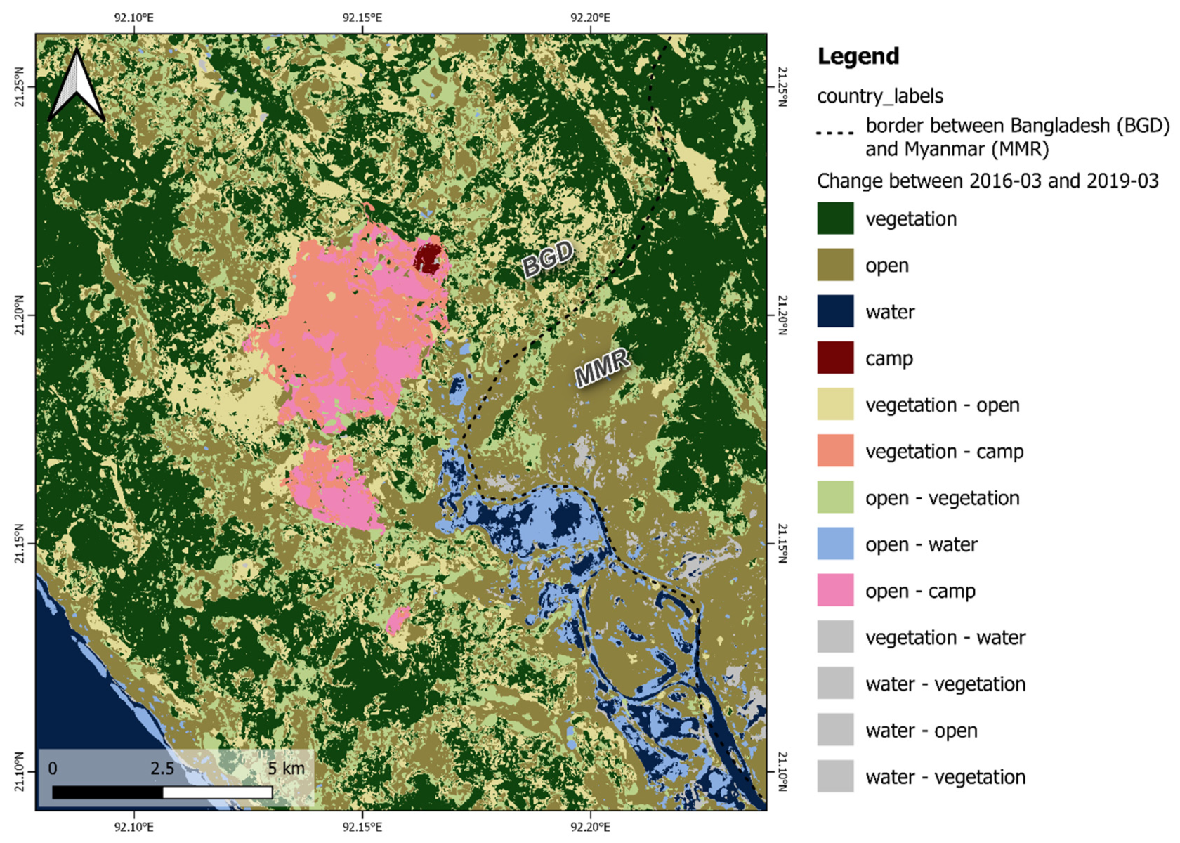
The presented insights on the development of vegetation patterns and the growth of the Kutupalong refugee camp are of higher detail than in all previously published studies. In particular, the incorporation of data from all seasons helps to understand the phenological variations and puts the overall developments into context. The suggested approach can be automated to a very large degree so that it can feed new data into monitoring frameworks, such as those conducted by the UNDP [
56], to ensure the protection of the Teknaf Wildlife Sanctuary and the livelihood of the people living in this area.


