Article

BDS-3 Time Group Delay and Its Effect on Standard Point Positioning

1
National Time Service Center, Chinese Academy of Sciences, Xi’an 710600, China
2
University of Chinese Academy of Sciences, Beijing 100049, China
3
Key Laboratory of Precise Positioning and Timing Technology, Chinese Academy of Sciences, Xi’an 710600, China
4
School of Astronomy and Space Science, University of Chinese Academy of Sciences, Beijing 100049, China
*
Author to whom correspondence should be addressed.
Remote Sens. 2019, 11(15), 1819; https://doi.org/10.3390/rs11151819
Submission received: 4 June 2019 / Revised: 18 July 2019 / Accepted: 1 August 2019 / Published: 3 August 2019
(This article belongs to the Special Issue Global Navigation Satellite Systems for Earth Observing System)

Abstract

:
The development of the BeiDou navigation system (BDS) is divided into three phases: The demonstration system (BDS-1), the regional system (BDS-2) and the global BeiDou navigation system (BDS-3). At present, the construction of the global BeiDou navigation system (BDS-3) constellation network is progressing very smoothly. The signal design and functionality of BDS-3 are different from those of BDS-1 and BDS-2. The BDS-3 satellite not only broadcasts B1I (1561.098 MHz) and B3I (1268.52 MHz) signals but also broadcasts new signals B1C (1575.42 MHz) and B2a (1176.45 MHz). In this work, six tracking stations of the international GNSS monitoring and assessment system (iGMAS) were selected, and 41 consecutive days of observation data, were collected. To fully exploit the code observations of BDS-2 and BDS-3, the time group delay (TGD) correction model of BDS-2 and BDS-3 are described in detail. To further verify the efficacy of the broadcast TGD parameters in the broadcast ephemeris, the standard point positioning (SPP) of all the signals from BDS-2 and BDS-3 with and without TGD correction was studied. The experiments showed that the B1I SPP accuracy of BDS-2 was increased by approximately 50% in both the horizontal and vertical components, and B1I/B3I were improved by approximately 70% in the horizontal component and 47.4% in the vertical component with TGD correction. The root mean square (RMS) value of B1I and B1C from BDS-3 with TGD correction was enhanced by approximately 60%–70% in the horizontal component and by approximately 50% in the vertical component. The B2a-based SPP was increased by 60.2% and 64.4% in the east and north components, respectively, and the up component was increased by approximately 19.8%. For the B1I/B3I and B1C/B2a dual-frequency positioning accuracy with TGD correction, the improvement in the horizontal component ranges from 62.1% to 75.0%, and the vertical component was improved by approximately 45%. Furthermore, the positioning accuracy of the BDS-2 + BDS-3 combination constellation was obviously higher than that of BDS-2 or BDS-3.

Graphical Abstract

1. Introduction

The BeiDou constellation began providing positioning, navigation and timing (PNT) services at least in the Asia-Pacific region in December 2012 [1]. The development of the BeiDou constellation has three phases: The BeiDou satellite navigation experimental system (BDS-1), the construction of the regional BeiDou system (BDS-2) and the construction of a global BeiDou system (BDS-3) [2]. By the end of 2012, BDS-2 consisted of five geostationary earth orbits (GEOs), five inclined geosynchronous orbits (IGSOs) and four medium altitude earth orbit (MEO) satellites. The BDS-3 constellation started in 2015 and is expected to provide global service with 5 GEO, 3 IGSO and 27 MEO satellites by 2020 [3]. With the rapid development of the BDS-2 constellation, BDS-2 has become a hot topic in the GNSS application community [4,5,6]. Many studies on BDS-2 have been carried out. Zhao et al. [7] presented the initial results of the BDS-2 precise orbit determination (POD). With the precise orbit and clock released by the IGS multi-GNSS experiment (MGEX), it provides the conditions for the study of the precise application of BDS-2 [8,9]. In addition, Guo et al. [10] investigated the effectiveness of the broadcast time group delay (TGD) in the navigation message and differential code biases (DCBs) provided by the MGEX; both the standard point positioning (SPP) and precise point positioning (PPP) were carried out for BDS signals with and without code bias correction. In addition, the triple-frequency ambiguity resolution performance using real BDS-2 data was investigated by Zhang et al. [11]. They illustrated that a minor improvement could be achieved by using triple-frequency observations compared with using dual-frequency observations. Furthermore, Manzino et al. [12] concluded that the GPS-BDS PPP combination presented a slightly better performance in comparable conditions and smaller intervals with the static model. Moreover, a special problem for BDS-2 is the satellite-induced code bias, which was investigated by Wanninger and Beer [13].
Before the launch of the BDS-3 satellites, the experimental BDS-3 (BDS-3e) system consisting of 3 MEO and 2 IGSO satellites was launched [14,15,16]. Since 2015, BDS-3e has implemented and validated new modes of navigation signals and inter-satellite links. In the last few years, many studies on BDS-3e have been carried out [14,15,16]. Li et al. [3] analysed the POD for the BDS-3e satellites with the international GNSS continuous monitoring and assessment system (iGMAS) and MGEX tracking networks. In addition, Xu et al. [16] presented the performances of the POD and PPP of the onboard BDS-3e satellites. Precise orbit and clock determination for BDS-3e satellites with yaw attitude using the extend center for orbits determination in Europe (CODE) orbit model (ECOM) has been illustrated by Zhao et al. [17]. Interestingly, there is no satellite-induced code bias in the BDS-3e satellites. From multipath-free conditions, the satellite-induced code variations that still exist in the bands of B1C, B2a and B2b of BDS-3e satellites were investigated by Zhou et al. [18]. Furthermore, Yang et al. [2] studied the performances of the BDS-3 demonstration system, including the signal-to-noise ratios, code errors and the multipath errors of the civilian signals. Moreover, the DCBs and the performance of both satellites and the receiver DCBs for BDS-3e using iGMAS and MEGX network observation data were evaluated by Li et al. [19]. The results showed that the DCBs estimated from the BDS-3e satellite were more stable than those from the BDS-2 satellite.
However, the BDS-3e satellite is not part of the BDS-3 constellation. From November 2017 to May 2019, 18 MEO, 1 GEO and 1 IGSO BDS-3 satellites (excluding experimental satellites) have been launched successfully. As a global system, BDS-3 has provided basic services to the countries along the Belt and Road and the neighboring regions since the end of 2018. The basic status information of the BDS-3 satellites is listed in Table 1. A new satellite attitude mode, signals, and atomic clocks have been applied on the BDS-3 satellite. Five frequencies are used to transmit signals: Backward-compatible old signals B1I (1561.098 MHz) and B3I (1268.52 MHz) and three new open service signals B1C (1575.42 MHz), B2a (1176.45 MHz) and B2b (1207.14 MHz). The B3I signal of the BDS-3 satellites is consistent with that of BDS-2, which uses binary phase-shift keying (BPSK) modulation according to the B3I Interface Control Document (ICD) [20]. The B1C signal has two signal components: A data component (B1C_data) and a pilot component (B1C_pilot), which use the binary offset carrier (BOC) and a quadrature multiplexed binary offset carrier (QMBOC) modulation, respectively, according to the B1C ICD [21]. Similar to the B1C signal, the B2a signal also has two signal components, a data component (B2a_data) and a pilot component (B2a_pilot), but the B2a signal components use the same modulation mode BPSK according to the B2a ICD [22]. The B1C signal shares the same frequency as the GPS L1 and Galileo E1 signals; the B2a signal matches the GPS L5 and Galileo E5a signals; and the B2b signal is compatible with the Galileo E5b signal. Similarly, the BDS-3 B2b signal also matches the BDS-2 B2I signal but uses a different modulation type [23]. The frequencies, signal components, modulations, wavelengths and chip rates of the BDS-3 open service signals are listed in Table 2. Xie et al. [23] analysed the characterization of the BDS-3 satellite GNSS signals with the iGMAS network. The results indicated that the satellite-induced code bias was negligible at all signals of the BDS-3 satellite, while BDS-3 triple-carrier combinations of small inter-frequency clock bias (IFCB) variations with peak amplitudes of approximately 1 cm can be recognized. Ye et al. [24] analysed the orbits of two BDS-3 satellites, C27 and C28, and the results showed that the median of the observed residuals computed using code observations and the solved initial orbits were better than four, when the new code signal was utilized. Until now, BDS-3e has been analysed by many experts and scholars. However, limited research has focused on BDS-3 satellites, especially for the TGD correction. GNSS (e.g., GPS, GLONASS, BDS and Galileo) codes are well known to be affected by TGD parameters. The TGD correction model for GPS, BDS-2 and Galileo was investigated in detail by Guo et al. [10]. Nevertheless, the TGD correction model of the old signals and new signals of BDS-3 have not been summarized and investigated in detail. From this background, the aim of this paper is to investigate the impact of TGD correction on BDS-3 positioning.
This paper is organized as follows. After this introduction, the TGD correction models of BDS-3 are developed to cover all critical BDS-3 positioning scenarios. In the following section, the experimental data and processing strategies are presented. Then, we analysed the impact of TGD correction on SPP for BDS-2, BDS-3 and the BDS-2 + BDS-3 combination. Finally, the conclusions are given.

2. Methodology

2.1. General Observation Model

The observation equation of code P can be expressed as [25]
P r , j S = ρ r S + c d t r c d t S + d t r o p + γ j S I r , 1 S + ( d r , j d j S ) + B j + ε r , j S ( P r , j S )
where r, S and j refer to the receiver, satellite and frequency, respectively; ρ r S denotes the geometric distance between the satellite S and the receiver r; c represents the speed of light; d t S and d t r are satellite clock offsets and the receiver clock difference between the local time and the system time in seconds, respectively; I r , 1 S indicates the slant ionospheric delay on the frequency f 1 S ; γ j S refers to the frequency-dependent multiplier factor ( γ j S = ( f 1 S f j S ) 2 ); d r , j and d j S represent the uncalibrated code delays (UCDs) at the receiver and satellite end, respectively; B j is the code biases on frequency j. ε r , j S ( P r , j S ) are the noise and multipath error for code observations, respectively.
Currently, the broadcast ephemeris of BDS-3 is divided into two types. One broadcast ephemeris refers to the old signals (B1I and B3I); we call this broadcast ephemeris the old broadcast ephemeris. The other broadcast ephemeris refers to the new signals (B1C and B2a); we call this broadcast ephemeris the new broadcast ephemeris. Compared with the orbit model of BDS-3 with the old broadcast ephemeris, the orbit model of BDS-3 with the new broadcast ephemeris is different, which has been introduced in the BDS-3 ICD [21,25].
Note that the BDS-3 satellite clock is referred to in both the old and new broadcast ephemerides with respect to the B3I signal. Hence, the BDS-3 application using other signals or combined signals differing from the conventional reference signal should apply TGD corrections, which are essential for code-based timing, positioning and ionosphere modelling [10,26]. The correction models of TGD for BDS-3 will be derived and extended to various situations in the next subsection in detail.

2.2. Single-Frequency Users

For single-frequency users, two important issues need to be considered. One issue is the ionospheric delay. Another issue is TGD corrections. Usually, the ionospheric delay is corrected by the Klobuchar model with eight parameters (K8) for B1I, B2I and B3I according to the released public BDS-2 ICD [27] or ionospheric models derived from global ionospheric maps (GIMs) [28]. However, the GIM model does not meet real-time applications; hence, the Klobuchar model is applied in this contribution. With the new signals (B1C and B2a) released by BDS-3, the ionospheric delay correction model does not use the Klobuchar model with eight parameters; instead the BeiDou global ionospheric delay correction model (BDSGIM) is used. The detailed correction model has been expressed in the BDS-3 ICD [25].
When BDS-3 satellites B1I or B3I are used with the old broadcast ephemeris, B j can be described as
{ B B 1 I = T G D 1 B B 3 I = 0
where T G D 1 is the “equipment group delay differential” with respect to the B3I signals to maintain signal coherence [29]. When the B3I signal is used, the code bias will not be considered because the broadcast satellite clock offset is based on the B3I signal [20].
When the BDS-3 satellites B1C or B2a are used with the new broadcast ephemeris, B j can be described as
{ B B 1 C = T G D B 1 C p B B 2 a = T G D B 2 a p
where T G D B 1 C p is the group delay differential of the B1C pilot component [21] and T G D B 2 a p is the group delay differential of the B2a pilot component.

2.3. Dual-Frequency Users

For dual-frequency users, the first-order ionospheric delay will be removed by the dual-frequency ionospheric-free combination model. The higher-order ionospheric delay is not considered herein. Although the ionospheric delay is corrected by the ionospheric-free combination model, the TGD corrections still need to be considered for different frequency combinations.
In the BeiDou navigation satellite system open service performance standard (version 2.0), the signals B1I or B1C are recommended for single-frequency services, while the signal combinations B1I/B3I and B1C/B2a are recommended for dual-frequency services [30]. When the B1I/B3I or B1C/B2a ionospheric-free model is used, the code biases B B 1 I / B 3 I and B B 1 C / B 2 a can be expressed as
{ B B 1 I / B 3 I = f B 1 I 2 f B 1 I 2 f B 3 I 2 T G D 1 B B 1 C / B 2 a = f B 1 C 2 T G D B 1 C p f B 2 a 2 T G D B 2 a p f B 1 C 2 f B 2 a 2

3. Experimental Data and Processing Strategies

In this experiment, the observation data were selected from six stations provided by iGMAS, namely, BRCH, GUA1, LHA1, WUH1, XIA1, XIA5. The data set is from the days of the year (DOYs) 1 to 41, 2019. The sampling rate is 30 s. All iGMAS stations can track all BDS-3 open signals. The BDS-3 old frequency B1I and B3I broadcast ephemeris are provided by MGEX, and the new frequency B1C and B2a broadcast ephemeris are provided by iGMAS. The data processing strategies of single- and dual-frequency for BDS-2, BDS-3 and BDS-2 + BDS-3 are detailed in Table 3. In Table 3, “non-corr” means code without TGD correction, and “tgd-corr” means code bias correction with TGD parameters in the navigation message. Note that B1I/B3I represents the B1I and B3I ionospheric-free combination SPP model. B1I refers to the single-frequency (B1I) SPP model. The other combination shows similar characteristics. During data processing, the parameter estimation method uses the least squares method, and the troposphere model adopts the Saastamoinen model. The ionospheric delay of the BDS-2 B1I and B3I signals is corrected by the K8 model. With the new signals (B1C and B2a) released by BDS-3, the ionospheric delay correction model adopts the BDSGIM. For dual-frequency data processing, ionospheric delay is used for the dual-frequency ionospheric-free combination. The summaries of the stations are shown in Table 4. Figure 1 shows the distribution of all the stations. The station coordinates in the SINEX file provided by iGMAS (http://112.65.161.230/download/index.php; ftp://222.240.181.170/products/) are used as references values to assess the positioning accuracy [31]. It is noteworthy that the difference between the iGMAS and IGS station coordinates’ precision is at the millimetre level [32,33]. Therefore, the iGMAS station coordinates are sufficient to assess the positioning accuracy.

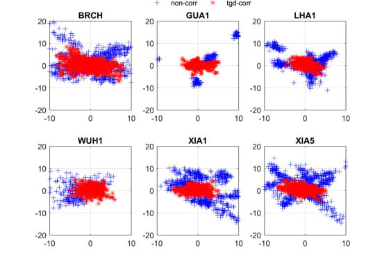
4. Validation and Analysis

4.1. BDS-2

We focus first on Figure 2, Figure 3 and Figure 4 as a typical example, depicting the positioning errors of 21 January 2019 for the east (E), north (N), and up (U) components of B1I and B3I based on BDS-2 SPP with and without TGD correction for the six selected stations. Figure 5 and Figure 6 show the positioning errors of the B1I/B3I ionosphere-free combined E, N, and U components of the BDS-2 SPP at six stations with and without TGD correction on the same day. Note that DOY 21, 2019 (21 January 2019) was randomly selected an example of our study. The other days show similar characteristics, and we do not describe them herein. From the five figures, we can obtain the following four conclusions. First, we can see that Figure 4 is the B3I single-frequency signal with the “non-corr” scheme. As mentioned before, the satellite clocks of BDS-2 in broadcast ephemerides refer to B3I signals. Second, as shown in Figure 2, Figure 3, Figure 4, Figure 5 and Figure 6, the metre-level positioning accuracy can be achieved with single- and dual-frequency SPP based on the BDS-2. Third, as a point of interest, from Figure 2, Figure 3, Figure 5 and Figure 6, we can see that the significant improvements in the “tgd-corr” scheme are presented. For example, as shown in Figure 2, the horizontal positioning error in the “non-corr” scheme is in the range of −5 m to 5 m, while in “tgd-corr” the scheme is within the range of −2 m to 2 m at the LHA1 station. In Figure 3, the vertical positioning error of the “non-corr” scheme is in the range of −5 m to 5 m, but the result of the “tgd-corr” scheme is within −2 m to 2 m at the LHA1 station. Fourth, by comparing Figure 2, Figure 3, Figure 5 and Figure 6, we can note that the positioning accuracy of the dual-frequency SPP based on B1I/B3I is even worse than that of the single-frequency based B1I and B3I signals. This phenomenon can be explained by the fact that the noise amplification factor is 3.5 [10] in the B1I/B3I dual-frequency signal based on the SPP scheme.
Figure 7 depicts the box-whisker diagrams of the distribution of three-dimensional (3D) positioning errors in the “tgd-corr” and “non-corr” schemes for the BRCH, GUA1, LHA1, WUH1, XIA1 and XIA5 stations for the period of 41 days. In these diagrams, values are considered outliers if they are less than Q 1 1.5 I Q R or greater than Q 3 + 1.5 I Q R , where Q 1 , Q 3 and I Q R denote the first quartile, the third quartile and inter-quartile range of the distribution, respectively. It is intuitively shown in Figure 7 that the number of outliers is very small for all the frequencies at each station. Since the BDS-2 codes are affected by TGD parameters, the “tgd-corr” scheme exhibits better positioning results, which results in reduced positioning errors compared to the “non-corr” scheme. This result is reflected in the distribution of the positioning errors from the “tgd-corr” scheme, exhibiting median and 75th percentile values below 10 m, except at the BRCH station, for all frequencies, as depicted in Figure 7. Furthermore, it can be concluded that the median and 75th percentile values in the Asia-Pacific region are less than those at the BRCH station. We will explain this phenomenon further below. Moreover, the median and 75th percentile values of the “tgd-corr” scheme are less than those of the “non-corr” scheme.
To analyse the BDS-2 positioning accuracy from different schemes based on the SPP more clearly, the root mean square (RMS) of the single- and dual-frequency SPP are calculated, and we plot the RMS of each day for the different stations (Figure 8). In addition, the improvements in the E, N, U components of the “tgd-corr” scheme compared to the “non-corr” scheme at different stations are shown in Figure 9. In Figure 9, we first obtain the mean RMS values of the 41-day SPP solutions at each station. The improvements from the "tgd-corr" scheme are then calculated and compared to those from the “non-corr” scheme. In addition, the mean values at the six stations are summarized in Table 5. Note that the outliers appearing in SPP are treated as follows. The pre-test and post-test residuals are checked in our program. Observations are deleted when the absolute value of residual is greater than 30 m. The main conclusion to be drawn from Figure 8 and Figure 9, in conjunction with Table 5, is straightforward. It is obvious that both the single- and dual-frequency SPP of the BDS-2 can achieve metre-level positioning accuracy. As we can see from Figure 8, the results based on B1I and B1I/B3I SPP without TGD correction deviate from the true position. From Figure 9, we can conclude that the accuracy of B1I/B3I- or B1I- based SPP with TGD correction, in addition to that at the BRCH station, in the E and N components increased by more than 50%, and the U component increased in the range of 25% to 50%. The reason for the slight improvement at the BRCH station is that BRCH is in Europe, so the number of observed BDS-2 satellites is relatively small, which results in an unsatisfactory equation structure. We can further explain from Figure 10, which shows the average global position dilution of precision (PDOP) on DOY 10, 2019, with an elevation cut-off angle of 5°. The PDOP is a spatial geometric intensity factor of the satellite distribution; the better the general satellite distribution is, the smaller the PDOP value. From Figure 10, we can conclude that the BDS-2 PDOP presents obvious regional characteristics. The PDOP value of the BRCH station in Europe is greater than that of the Asia-Pacific region where the other stations are located, which support our previous findings. In addition, some BDS-2 satellites have a high degree of noise at lower elevation angels in the European region. Hence, the TGD correction of the BDS-2 system has less effect on the accuracy of the BRCH station. From the average RMS values of the six stations in Table 5, compared with the “non-corr” scheme of the B1I-based solutions, the positioning accuracy of the “tgd-corr” scheme is notably improved by 52.4% from 2.69 m to 1.28 m and by 57.8% from 2.3 m to 0.97 m in the horizontal directions. In addition, for the vertical direction, the B1I-based positioning results are improved by 45.6% from 4.08 m to 2.22 m. Interestingly, the B3I-based positioning results are not affected by the TGD parameter because the satellite clocks of BDS-2 in the broadcast ephemeris refer to the B3I signal. Under the “tgd-corr” scheme, the RMS values of single- and dual-frequency signals for the horizontal and vertical components are 1 m–2 m. For the “tgd-corr” scheme, the RMS values of the B1I/B3I combination are significantly reduced by 70.1% from 5.36 m to 1.6 m, by 74.2% from 5.12 m to 1.32 m and by 47.4% from 5.67 m to 2.98 m for the E, N and U components, respectively.

4.2. BDS-3

Figure 11, Figure 12, Figure 13, Figure 14, Figure 15, Figure 16 and Figure 17 present the horizontal and vertical positioning error scatters plots of the BDS-3 single-frequency SPP, with and without TGD correction, from 21 January 2019 for the six stations. It should be explained that the data are discontinuous because of the lack of observational data in the figures. In addition, we mentioned before that the pre-test and post-test residuals will be checked in our program, and the observations will be deleted when the absolute value of the residual is greater than 30 m. Considering all seven figures, there are three findings highlighted here. First, simultaneously considering Figure 13, Figure 14, Figure 15 and Figure 16, it can be seen that the positioning accuracy values of the B1C and B2a signals have improved significantly with the “tgd-corr” scheme. We can conclude that the TGD parameters need to be modified in the B1C-and B2a-based positioning. As mentioned in the ICD file, the TGD of B1C is the group delay differential between the B1C pilot component and the B3I signal, and the TGD of B2a is the group delay differential between the B2a pilot component and the B3I signal. Second, both the old signals and the new signals, in the case of correcting the TGD parameters, can achieve the metre-level positioning accuracy. Third, we can clearly see that the “tgd-corr” scheme results in a significant improvement compared to the “non-corr” scheme positioning results in the E, N and U components. Taking the B1C signal of the LHA1 station as an example, in Figure 13 and Figure 14, the horizontal and vertical positioning errors are within the range of −5 m to 5 m after the correction of the TGD parameters, and those from the uncorrected TGD parameters range from −10 m to 10 m.
We now turn to Figure 18, Figure 19, Figure 20 and Figure 21, in which the four panels separately show the horizontal and vertical positioning error scatter plots of BDS-3 B1I/B3I- and B1C/B2a-based SPP from 21 January 2019. As we can see from the four figures, both the old and new signals of BDS-3 dual-frequency SPP can reach metre-level positioning accuracy. We focus on the B1C/B2a-based positioning errors shown in Figure 20 and Figure 21. The positioning error from the “tgd-corr” scheme is within ±5 m, and the positioning error from the “non-corr” scheme is within ±10 m in the E, N and U components. Combined with Figure 17 and Figure 18, we can still conclude that the TGD correction effect of the new signal is obviously similar to that of the old signal. Interestingly, we note that the noise in the dual-frequency positioning errors is greater than that in the single-frequency positioning errors. We surmise that this finding may be attributed to the fact that noise is magnified in the dual-frequency SPP scheme [10].
Figure 22 shows box-whisker diagrams of the distributions of the positioning errors in the tgd-corr and non-corr schemes for the six stations for the 41-day period. The outliers, first quartile, third quartile and inter-quartile range in the distribution in the figure are as stated before. There are three findings highlighted here. First, it is obvious in the figure that the number of outliers at each station is very small, which further proves that positioning using BDS is reliable. Second, unlike for BDS-2, the positioning errors for all stations are basically similar; thus, we can conclude that BDS-3 eliminated the regional limitation characteristics of BDS-2. Third, including the BRCH station, the medians and 75th percentiles from the “tgd-corr” scheme at all stations is less than 10 m. For the “non-corr” scheme, the medians and 75th percentiles are much larger than those from the “tgd-corr” scheme, which proves that the TGD parameters need to be corrected for BDS-2 positioning.
To further quantify the positioning accuracy, we give the RMS values for the daily single- and dual-frequency positioning errors with and without TGD correction for the BRCH station, displayed in Figure 23 and Figure 24. In the two figures, it is clearly shown that both the single- and dual-frequency positioning accuracy values with TGD correction are better than those without TGD correction. The positioning accuracy of B1C- and B2a-based BDS-3 SPP is similar to that of B1I- and B3I-based SPP. The above results can be further demonstrated in Figure 25, showing the improvement in the E, N and U components from the “tgd-corr” scheme compared to that from the "non-corr" scheme at different stations. First, we consider the single-frequency positioning accuracy. Taking the B1C signal as an example, the horizontal positioning accuracy with the “tgd-corr” scheme is more than 50% higher than that with the “non-corr” scheme, and the vertical positioning accuracy is improved by more than 25%. The B1I- and B2a-based SPP results at other stations show similar features to those of the B1C signal; we will not describe them in detail herein. Second, for the positioning accuracy of B1C/B2a- and B1I/B3I-based SPP, the horizontal positioning accuracy based on the "tgd-corr" scheme compared to the “non-corr” scheme improved in the range of 33.93% to 85.08%, and the vertical positioning accuracy was improved in the range of 30.12% to 59.19%. We also calculated the means of the RMSs at different frequencies and different schemes for 41 days at the six stations (Table 6). The empirical analysis of the obtained results yielded three conclusions. First, the signal- and dual-frequency SPP solutions without the TGD correction present the systematic error. Compared with the "non-corr" scheme, the accuracy in B1I SPP is improved with the TGD correction by approximately 68.0%, 69.2% and 49.2% in the N, E and U components, respectively. The positioning errors of B1C SPP with the "tgd-corr" scheme are reduced by 64.8% from 1.18 m to 3.35 m and by 64.4% from 1.48 m to 4.16 m and by 51.2% from 2.91 m to 5.96 m in the E, N and U components, respectively. In the “tgd-corr” scheme, the RMS values of B2a SPP are significantly reduced by 60.2% from 2.84 m to 1.13 m, by 55.4% from 3.59 m to 1.60 m and by 19.8% from 5.09 m to 4.18 m in the E, N and U components, respectively. Likewise, compared with the "non-corr" scheme, the RMS of B1I/B3I SPP is reduced by 75% and 71% in the horizontal components, and the positioning accuracy can reach 1 m–2 m after TGD correction, and the vertical component is reduced by 45.4%, from 5.42 m to 2.96 m. The accuracy of B1C/B2a SPP with the “tgd-corr” scheme is improved by 66.1% and 62.1% on the horizontal components, the N and E can reach 1.66 m and 1.85 m by correcting the TGD parameters, respectively, and the vertical component is improved by 43.3%, from 6.31 m to 3.58 m. Second, we focus on the new signals from BDS-3. We observe that the positioning accuracy of the new signals is analogous to that of the old signals of BDS-3. Both the new and old signals can achieve a positioning accuracy similar to that of BDS-2. However, BDS-2 provides regional location services, while BDS-3 provides global location services. Third, we note that the positioning accuracy of the dual-frequency SPP is even worse than that of single-frequency: This result is affected by the fact that the dual-frequency observation noise is significantly enlarged due to different factors, including the TGD parameter error.
We now turn to Figure 26, which depicts the code residual scatters at the BRCH station with different schemes, with each colour representing different satellites. We see that there is a clear system bias in the code residual of each satellite with the “non-corr” scheme. It is noteworthy that there is no significant system bias with the “tgd-corr” scheme; thus, this finding further verifies that the TGD of the old and new signals from BDS-3 need to be modified. Comparing the two schemes, it can be found that the data from the “non-corr” scheme are less than the data from the “tgd-corr” scheme, possibly because the code residuals are too large during the calculation process. We focus on Figure 27, which shows the average global PDOP on DOY 10 2019, with an elevation cut-off angle of 5°. Compared with Figure 10, we can clearly conclude that the global PDOP value for BDS-3 is less than that for BDS-2, which further supports our previous conclusions. The number of BDS-3 satellites has increased in Europe, making the correction of the TGD parameters more significant for the BRCH stations. With the rapid development of BDS-3, it now has a global network of 20 satellites and provides global services. We also expect that a better performance from BDS-3 can be reached when the global system is completed in 2020.

4.3. BDS2 + BDS-3

With the previous validation, we can conclude that the TGD parameters of the B1I, B1C and B2a signals need to be corrected. Therefore, for the BDS-2 + BDS-3 combination, we give only the positioning results with the TGD correction in this subsection. Figure 28, Figure 29, Figure 30 and Figure 31 display the horizontal and vertical positioning error scatter plots for B1I and B3I SPP on 21 January 2019. The positioning errors in the B1I/B3I signal from a single day are described in Figure 32 and Figure 33. From the positioning results, it can be concluded that the positioning accuracy of the BDS-2 + BDS-3 combined system is higher than that of BDS-2 or BDS-3 because the increase in the number of BDS-3 satellites has made up for the regional limitations of BDS-2.
To further evaluate the impact of the TGD parameters on the positioning accuracy of BDS-2 + BDS-3, the daily RMS values for each station are calculated (Figure 34), and the mean values for all stations are shown in Table 7. Compared with BDS-2 and BDS-3, we can conclude that the positioning accuracy of the BDS-2 + BDS-3 combination system performs better than BDS-2 or BDS-3. Moreover, the single- and dual-frequency positioning errors of BDS-2+BDS-3 can reach 1 m–2 m. We expect that BDS-2 + BDS-3 can achieve a better performance when the global system will be completed in 2020.

5. Conclusions

China’s BDS-3 system is rapidly developing; from November 2017 to May 2019, 18 MEO, 1 GEO and 1 IGSO BDS-3 satellites (excluding experimental satellites) have been successfully launched. As a global system, BDS-3 has already provided basic services to the countries along the Belt and Road and to the neighbouring regions since the end of 2018. This work aims to investigate the impact of TGD on BDS-2, BDS-3 and BDS-2 + BDS-3 positioning. In this contribution, the single- and dual-frequency positioning accuracy of the BDS-3 signals were analysed. Six iGMAS stations, which can receive all the BDS-2 and BDS-3 signals at the current stage, with 41-day observation data, were selected to support our findings.
Single- (B1I, B3I, B1C and B2a) and dual-frequency (B1I/B3I and B1C/B2a) BDS-2, BDS-3 and BDS-2 + BDS-3 combined system signals were assessed with and without TGD correction. The results showed that the RMS value of B1I SPP with the “tgd-corr” scheme was increased by approximately 50% compared with the “non-corr” scheme based on BDS-2 satellites. For the positioning accuracy of all BDS-3 signals, the single- and dual-frequency-based SPP solutions without TGD correction present systematic errors deviating from the true positions. The accuracy of B1I SPP is improved by approximately 68.0%, 69.2% and 49.2% with TGD correction in the N, E and U components respectively, compared to SPP without TGD correction. The positioning accuracy of B1C SPP with the "tgd-corr" scheme is reduced by 64.8% from 1.18 m to 3.35 m and by 64.4% from 1.48 m to 4.16 m and by 51.2% from 2.91 m to 5.96 m in the E, N and U components, respectively. The RMS of B2a SPP is significantly reduced by 60.2% from 2.84 m to 1.13 m, by 55.4% from 3.59 m to 1.60 m and by 19.8% from 5.09 m to 4.18 m in E, N and U components, respectively. Compared with the "non-corr" scheme, the RMS of B1I/B3I SPP is reduced by 75%, 71.0% and 45.4% in the horizontal and vertical components, and the positioning accuracy can reach 1 m–2 m after TGD correction. The positioning accuracy of B1C/B2a SPP with the "tgd-corr" scheme is improved by 66.1% and 62.1% in the horizontal components. The N and E components can reach 1.66 m and 1.85 m, respectively, and the vertical component is improved by 43.3%, from 6.31 m to 3.58 m. The regional limitations of BDS-2 were overcome when BDS-3 satellites were put into use; hence, the global positioning accuracy of the BDS-2 + BDS-3 combined system is better than that of the BDS-2 or BDS-3. We expect that a better performance of BDS-3 can be reached when the global system completed.

Author Contributions

P.D., Y.G., W.Q. and X.Y. conceived and designed the experiments; P.D. performed the experiments, analyzed the data, and wrote the paper; X.Y. and Y.G. helped in the discussion and revision.

Funding

This work was supported by the National Natural Science Foundation of China (No. 11703033), Natural Science Foundation of Shaanxi (No.2018JQ1020) and Youth promotion committee of Chinese Academy of Sciences. The authors acknowledge iGMAS for funding.

Acknowledgments

The authors gratefully acknowledge iGMAS and IGS for providing broadcast ephemeris, data, and satellite information.

Conflicts of Interest

The authors declare no conflict of interest.

References

  1. Lou, Y.; Liu, Y.; Shi, C.; Yao, X.; Zheng, F. Precise orbit determination of BeiDou constellation based on BETS and MGEX network. Sci. Rep. 2014, 4, 4692. [Google Scholar] [CrossRef] [PubMed] [Green Version]
  2. Yang, Y.; Xu, Y.; Li, J.; Yang, C. Progress and performance evaluation of BeiDou global navigation satellite system: Data analysis based on BDS-3 demonstration system. Sci. China Earth Sci. 2018, 6, 614–624. [Google Scholar] [CrossRef]
  3. Li, X.; Yuan, Y.; Zhu, Y.; Huang, J.; Wu, J.; Xiong, Y.; Zhang, X.; Li, X. Precise orbit determination for BDS3 experimental satellites using iGMAS and MGEX tracking networks. J. Geod. 2018, 93, 103–117. [Google Scholar] [CrossRef]
  4. Ge, Y.; Yang, X.; Qin, W.; Su, H.; Wu, M.; Wang, Y.; Wang, S. Time Transfer Analysis of GPS- and BDS-Precise Point Positioning Based on iGMAS Products. China Satell. Navig. Conf. 2018, 497, 519–530. [Google Scholar]
  5. Ge, Y.; Yang, X.; Qin, W.; Yang, H.; Guang, W.; Zhou, F.; Ouyang, M.; Wang, S. Mitigation of the multipath effect in BDS-based time transfer using a wave-absorbing shield. Adv. Space Res. 2018, 63, 2771–2783. [Google Scholar] [CrossRef]
  6. Chu, F.Y.; Yang, M. BeiDou System (BDS) Triple-Frequency Ambiguity Resolution without Code Measurements. Remote Sens. 2018, 10, 675. [Google Scholar] [CrossRef]
  7. Zhao, Q.; Guo, J.; Li, M.; Qu, L.; Hu, Z.; Shi, C.; Liu, J. Initial results of precise orbit and clock determination for COMPASS navigation satellite system. J. Geod. 2013, 87, 475–486. [Google Scholar] [CrossRef]
  8. Li, X.; Zhang, X.; Ren, X.; Fritsche, M.; Wickert, J.; Schuh, H. Precise positioning with current multi-constellation Global Navigation Satellite Systems: GPS, GLONASS, Galileo and BeiDou. Sci. Rep. 2015, 5, 8328. [Google Scholar] [CrossRef]
  9. Guo, F.; Li, X.; Zhang, X.; Wang, J. The contribution of Multi-GNSS Experiment (MGEX) to precise point positioning. Adv. Space Res. 2016, 59, 2714–2725. [Google Scholar] [CrossRef]
  10. Guo, F.; Zhang, X.; Wang, J. Timing group delay and differential code bias corrections for BeiDou positioning. J. Geod. 2015, 89, 427–445. [Google Scholar] [CrossRef]
  11. Zhang, X.; He, X. Performance analysis of triple-frequency ambiguity resolution with BeiDou observations. GPS Solut. 2015, 20, 269–281. [Google Scholar] [CrossRef]
  12. Manzino, A.M.; Dabove, P.; Gogoi, N. Assessment of positioning performances in Italy from GPS, BDS and GLONASS constellations. Geod. Geodyn. 2018, 9, 439–448. [Google Scholar] [CrossRef]
  13. Wanninger, L.; Beer, S. BeiDou satellite-induced code pseudorange variations: diagnosis and therapy. GPS Solut. 2015, 19, 639–648. [Google Scholar] [CrossRef]
  14. Mao, Y.; Wang, Q.; Hu, C.; He, Y. Accuracy Analysis of BDS-3 Experiment Satellite Broadcast Ephemeris. China Satell. Navig. Conf. 2018, 498, 341–354. [Google Scholar]
  15. Wu, Z.; Zhou, S.; Hu, X.; Liu, L.; Shuai, T.; Xie, Y.; Tang, C.; Pan, J.; Zhu, L.; Chang, Z. Performance of the BDS3 experimental satellite passive hydrogen maser. GPS Solut. 2018, 22. [Google Scholar] [CrossRef]
  16. Xu, X.; Li, M.; Li, W.; Liu, J. Performance Analysis of Beidou-2/Beidou-3e Combined Solution with Emphasis on Precise Orbit Determination and Precise Point Positioning. Sensors (Basel) 2018, 18, 135. [Google Scholar] [CrossRef] [PubMed]
  17. Zhao, Q.; Wang, C.; Guo, J.; Wang, B.; Liu, J. Precise orbit and clock determination for BeiDou-3 experimental satellites with yaw attitude analysis. GPS Solut. 2017, 22. [Google Scholar] [CrossRef]
  18. Zhou, R.; Hu, Z.; Zhao, Q.; Li, P.; Wang, W.; He, C.; Cai, C.; Pan, Z. Elevation-dependent pseudorange variation characteristics analysis for the new-generation BeiDou satellite navigation system. GPS Solut. 2018, 22. [Google Scholar] [CrossRef]
  19. Li, X.; Xie, W.; Huang, J.; Ma, T.; Zhang, X.; Yuan, Y. Estimation and analysis of differential code biases for BDS3/BDS2 using iGMAS and MGEX observations. J. Geod. 2018, 93, 419–435. [Google Scholar] [CrossRef]
  20. CSNO. BeiDou Navigation Satellite System Signal in Space Interface Control Document, Open Service Signal B3I (Version 1.0); China Satellite Navigation Office: Beijing, China, February 2018. [Google Scholar]
  21. CSNO. BeiDou Navigation Satellite System Signal in Space Interface Control Document, Open Service Signal B1C (Version 1.0); China Satellite Navigation Office: Beijing, China, December 2017. [Google Scholar]
  22. CSNO. BeiDou Navigation Satellite System Signal in Space Interface Control Document, Open Service Signal B2a (Version 1.0); China Satellite Navigation Office: Beijing, China, December 2017. [Google Scholar]
  23. Xie, X.; Fang, R.; Geng, T.; Wang, G.; Zhao, Q.; Liu, J. Characterization of GNSS Signals Tracked by the iGMAS Network Considering Recent BDS-3 Satellites. Remote Sens. 2018, 10, 1736. [Google Scholar] [CrossRef]
  24. Ye, F.; Yuan, Y.; Ou, J. Initial orbit determination of BDS-3 satellites based on new code signals. Geod. Geodyn. 2018, 9, 342–346. [Google Scholar] [CrossRef]
  25. Leick, A.; Rapoport, L.; Tatarnikov, D. GPS Satellite Surveying, Fourth Edition; Wiley: Hoboken, NJ, USA, 2015. [Google Scholar]
  26. Ge, Y.; Zhou, F.; Sun, B.; Wang, S.; Shi, B. The Impact of Satellite Time Group Delay and Inter-Frequency Differential Code Bias Corrections on Multi-GNSS Combined Positioning. Sensors (Basel) 2017, 17, 602. [Google Scholar] [CrossRef] [PubMed]
  27. CSNO. BeiDou Navigation Satellite System Signal in Space Interface Control Document-Open Service Signal, Version 2.0; China Satellite Navigation Office: Beijing, China, December 2013. [Google Scholar]
  28. Hernández-Pajares, M.; Juan, J.M.; Sanz, J.; Orus, R.; Garcia-Rigo, A.; Feltens, J.; Komjathy, A.; Schaer, S.C.; Krankowski, A. The IGS VTEC maps: A reliable source of ionospheric information since 1998. J. Geod. 2009, 83, 263–275. [Google Scholar] [CrossRef]
  29. CSNO. BeiDou Navigation Satellite System Signal in Space Interface Control Document-Open Service Signal B1I, Version 1.0; China Satellite Navigation Office: Beijing, China, December 2012. [Google Scholar]
  30. CSNO. BeiDou Navigation Satellite System Open Service Performance Standard, Version 2.0; China Satellite Navigation Office: Beijing, China, December 2018. [Google Scholar]
  31. Jiao, G.; Song, S.; Ge, Y.; Su, K.; Liu, Y. Assessment of BeiDou-3 and Multi-GNSS Precise Point Positioning Performance. Sensors 2019, 19, 2496. [Google Scholar] [CrossRef] [PubMed]
  32. Ferland, R.; Piraszewski, M. The IGS-combined station coordinates, earth rotation parameters and apparent geocenter. J. Geod. 2009, 83, 385–392. [Google Scholar] [CrossRef]
  33. Cai, H.; Chen, K.; Xu, T.; Chen, G. The iGMAS Combined Products and the Analysis of Their Consistency. In Proceedings of the China Satellite Navigation Conference (CSNC), Xi’an, China, 13–15 May 2015. [Google Scholar]
Figure 1. The distribution of the six selected stations from the international GNSS continuous monitoring and assessment system (iGMAS).
Remotesensing 11 01819 g001
Figure 2. Horizontal positioning error scatter plots of B1I SPP with and without time group delay (TGD) correction at the selected stations. In each plot, the horizontal and vertical axes indicate the East (E) and North (N) components errors, respectively (unit: m).
Remotesensing 11 01819 g002
Figure 3. Vertical positioning error scatter plots of B1I SPP with and without TGD correction on the selected stations. In each plot, the horizontal and vertical axes indicate the universal time (h) and the Up (U) component error, respectively (unit: m).
Remotesensing 11 01819 g003
Figure 4. Positioning error scatter plots of B3I SPP without TGD correction for the BRCH station. In each plot, the horizontal axis indicates the universal time (h), and the vertical axes indicates the E, N and U component errors, respectively (unit: m).
Remotesensing 11 01819 g004
Figure 5. Horizontal positioning error scatter plots of B1I/B3I SPP with and without TGD correction at the selected stations. In each plot, the horizontal and vertical axes indicate the E and N component errors, respectively (unit: m).
Remotesensing 11 01819 g005
Figure 6. Vertical positioning error scatter plots of B1I/B3I SPP with and without TGD correction at the selected stations. In each plot, the horizontal and vertical axes indicate the universal time (h) and the U component errors, respectively (unit: m).
Remotesensing 11 01819 g006
Figure 7. Box-whisker diagrams of the distributions of the three dimensional (3D) positioning errors in the tgd-corr (red) and non-corr (blue) schemes at the BRCH, GUA1, LHA1, WUH1, XIA1 and XIA5 stations for the 41-day period (tgd: tgd-corr, non: non-corr) using the regional BeiDou system (BDS-2) satellites. The box heights and the bars inside the boxes denote the inter-quartile ranges (IQRs) and the medians of the distributions, respectively. The whiskers’ lengths represent the maximum and minimum values of distributions (unit: m). Outliers are identified with plus signs (see the text).
Remotesensing 11 01819 g007
Figure 8. Daily RMS values of BDS-2 with different schemes for the BRCH station.
Remotesensing 11 01819 g008
Figure 9. Improvements in the E, N, and U components of the “tgd-corr” scheme compared to the “non-corr” scheme at different stations. Note that the mean RMS of 41 days at each station with and without TGD correction is first obtained. The improvement from the “tgd-corr” scheme is then calculated and compared to that from the “non-corr” scheme.
Remotesensing 11 01819 g009
Figure 10. Average global PDOP of BDS-2 on day of the year (DOY) 10 2019 with an elevation cut-off angle of 5°.
Remotesensing 11 01819 g010
Figure 11. Horizontal positioning error scatter plots of B1I SPP with and without TGD correction for the six selected stations. In each plot, the horizontal and vertical axes indicate the E component error and the N component error, respectively (unit: m).
Remotesensing 11 01819 g011
Figure 12. Vertical positioning error scatter plots of B1I SPP with and without TGD correction for the six selected stations. In each plot, the horizontal and vertical axes indicate the universal time (h) and the U component error, respectively (unit: m).
Remotesensing 11 01819 g012
Figure 13. Horizontal positioning error scatter plots of B1C SPP with and without TGD correction for the six selected stations. In each plot, the horizontal and vertical axes indicate the E component error and the N component error, respectively (unit: m).
Remotesensing 11 01819 g013
Figure 14. Vertical positioning error scatter plots of B1C SPP with and without TGD correction for the six selected stations. In each plot, the horizontal and vertical axes indicate the universal time (h) and the U component error, respectively (unit: m).
Remotesensing 11 01819 g014
Figure 15. Horizontal positioning error scatter plots of B2a SPP with and without TGD correction for the six selected stations. In each plot, the horizontal and vertical axes indicate the E component error and the N component error, respectively (unit: m).
Remotesensing 11 01819 g015
Figure 16. Vertical positioning error scatter plots of B2a SPP with and without TGD correction for the six selected stations. In each plot, the horizontal and vertical axes indicate the universal time (h) and the U component error, respectively (unit: m).
Remotesensing 11 01819 g016
Figure 17. Vertical positioning error scatter plots of B3I SPP without TGD correction for the BRCH station. In each plot, the horizontal axis is the universal time (h) and the vertical axes indicate the errors of the E, N and U components (unit: m).
Remotesensing 11 01819 g017
Figure 18. Horizontal positioning error scatter plots of B1I/B3I SPP with and without TGD correction for the six selected stations. In each plot, the horizontal and vertical axes indicate the E component error and the N component error, respectively (unit: m).
Remotesensing 11 01819 g018
Figure 19. Vertical positioning error scatter plots of B1I/B3I SPP with and without TGD correction for the six selected stations. In each plot, the horizontal and vertical axes indicate the universal time (h) and the U component error, respectively (unit: m).
Remotesensing 11 01819 g019
Figure 20. Horizontal positioning error scatter plots of B1C/B2a SPP with and without TGD correction for the six selected stations. In each plot, the horizontal and vertical axes indicate the E component error and N component error, respectively (unit: m).
Remotesensing 11 01819 g020
Figure 21. Vertical positioning error scatter plots of B1C/B2a SPP with and without TGD correction for the six selected stations. In each plot, the horizontal and vertical axes indicate the universal time (h) and the U component error, respectively (unit: m).
Remotesensing 11 01819 g021
Figure 22. Box-whisker diagrams of the distributions of the 3D positioning errors in the tgd-corr (red) and non-corr (blue) schemes at the BRCH, GUA1, LHA1, WUH1, XIA1 and XIA5 stations for the 41-day period (tgd: tgd-corr, non: non-corr) using the BDS-3 satellites. The box heights and the bars inside the boxes denote the IQRs and medians of the distributions, respectively. The whiskers’ lengths represent the maximum and minimum values of the distributions (unit: m). Outliers are identified with plus signs (see text).
Remotesensing 11 01819 g022
Figure 23. Daily RMSs of old signals from BDS-3 with and without TGD correction for the BRCH station.
Remotesensing 11 01819 g023
Figure 24. Daily RMSs of the new signals from BDS-3 with and without TGD correction for the BRCH station.
Remotesensing 11 01819 g024
Figure 25. Improvements in the E, N and U components from the “tgd-corr” scheme compared to those from the “non-corr” scheme for different stations. Note that the 41-day mean RMS at each station with and without TGD correction is obtained first. The improvements from the “tgd-corr” scheme is then calculated and compared to those from the “non-corr” scheme.
Remotesensing 11 01819 g025
Figure 26. Code residual scatter plots for the BRCH station with/without TGD correction. In each plot, the horizontal and vertical axes indicate the universal time (h) and the code residual, respectively (unit: m).
Remotesensing 11 01819 g026
Figure 27. Average global PDOP of BDS-3 on DOY 10 2019, with an elevation cut-off angle of 5°.
Remotesensing 11 01819 g027
Figure 28. Horizontal positioning error scatter plots of B1I SPP with TGD correction for the six selected stations. In each plot, the horizontal and vertical axes indicate the E component error and the N component error, respectively (unit: m).
Remotesensing 11 01819 g028
Figure 29. Vertical positioning error scatter plots of B1I SPP with TGD correction for the six selected stations. In each plot, the horizontal and vertical axes indicate the universal time (h) and the U component error, respectively (unit: m).
Remotesensing 11 01819 g029
Figure 30. Horizontal positioning error scatter plots of B3I SPP with TGD correction for the six selected stations. In each plot, the horizontal and vertical axes indicate the E component error and the N component error, respectively (unit: m).
Remotesensing 11 01819 g030
Figure 31. Vertical positioning error scatter plots of B3I SPP with TGD correction for the six selected stations. In each plot, the horizontal and vertical axes indicate the universal time (h) and the U component error, respectively (unit: m).
Remotesensing 11 01819 g031
Figure 32. Horizontal positioning error scatter plots of B1I/B3I SPP with TGD correction for the six selected stations. In each plot, the horizontal and vertical axes indicate the E component error and the N component error, respectively (unit: m).
Remotesensing 11 01819 g032
Figure 33. Vertical positioning error scatter plots of B1I/B3I SPP with TGD correction for the six selected stations. In each plot, the horizontal and vertical axes indicate the universal time (h) and the U component error, respectively (unit: m).
Remotesensing 11 01819 g033
Figure 34. Daily RMSs of BDS-2 + BDS-3 at the BRCH station with TGD correction.
Remotesensing 11 01819 g034
Table 1. Satellite status of the global BeiDou system (BDS-3) (as of May 2019).
SatelliteSVNInt.sat.IDNORAD.IDManuf.PRNNotes
MEO-2C2022017-069B43002CASTC20Slot B-8; launched
5 November 2017
MEO-1C2012017-069A43001CASTC19SlotB-7; launched
5 November 2017
MEO-7C2032018-003A43107SECMC27Slot A-4; launched
12 January 2018
MEO-8C2042018-003B43108SECMC28Slot A-5; launched
12 January 2018
MEO-4C2052018-018A43207CASTC22Slot B-6; launched
12 February 2018
MEO-3C2062018-018B43208CASTC21Slot B-5; launched
12 February 2018
MEO-9C2072018-029A43245SECMC29Slot A-2; launched
30 March 2018
MEO-10C2082018-029B43246SECMC30Slot A-3; launched
30 March 2018
MEO-5C2092018-062A43581CASTC23Slot C-7; launched
29 July 2018
MEO-6C2102018-062B43582CASTC24Slot C-1; launched
29 July 2018
MEO-11C2112018-067A43602SECMC26Slot C-2; launched
25 August 2018
MEO-12C2122018-067B43603SECMC25Slot C-8; launched
25 August 2018
MEO-13C2132018-072A43622CASTC32Slot B-1; launched
19 September 2018
MEO-14C2142018-072B43623CASTC33Slot B-3; launched
19 September 2018
MEO-16C2152018-078A43647SECMC35Slot A-1; launched
15 October 2018
MEO-15C2162018-078B43648SECMC34Slot A-7; launched
15 October 2018
GEO-1C2172018-085A43683CASTC59Launched
1 November 2018
MEO-17C2182018-093A43706CASTC36Slot C-4; launched
19 November 2018
MEO-18C2192018-093B43707CASTC37Slot C-6; launched
19 November 2018
IGSO-1C2202019-023B44204--Launched
20 April 2019
Table 2. The summaries of the BDS-3 open service signals.
SignalSignal ComponentCarrier Frequency (MHz)ModulationWavelength (cm)Chip Rate (Mcps)
B1I-1561.098BPSK (2)19.22.046
B1CB1C_data1575.420BOC19.031.023
B1C_pilotQMBOC
B2aB2a_data1176.450BPSK (10)25.4810.23
B2a_pilot
B2b-1207.140QPSK24.8310.23
B3I-1268.520BPSK (10)23.6310.23
Table 3. The summaries of the processing strategies.
ModelSystemSingle-FrequencyDual-FrequencySchemes
SPPBDS-2B1I, B3IB1I/B3Inon-corr;
tgd-corr
BDS-3B1I, B3I, B1C, B2aB1I/B3I, B1C/B2a
BDS-2+BDS-3B1I, B3IB1I/B3I
Table 4. The six selected station information.
StationReceiverAntenna
BRCHCETC-54-GMR-4016NOV750.R4
GUA1GNSS-GGRRINT-8CH
LHA1CETC-54 GMR-4011NOV750.R4
WUH1CETC-54-GMR-4016LEIAR25.R4
XIA1GNSS-GGRRINT-8CH
XIA5CETC-54-GMR-4011TRM59900.00
Table 5. The mean root mean square (RMS) values of the six selected stations SPP solutions using 41-day observations with and without TGD correction in different BDS-2 frequency combinations (m).
SchemeB1IB3IB1I/B3I
Etgd-corr1.28-1.60
non-corr2.691.275.36
Improvement (%) 52.4-70.1
Ntgd-corr0.97-1.32
non-corr2.301.125.12
Improvement (%) 57.8-74.2
Utgd-corr2.22-2.98
non-corr4.082.755.67
Improvement (%)45.6-47.4
Table 6. The 41-day mean RMS values of the SPP solutions with/without TGD correction in different BDS-3 frequency combinations from the six selected stations (m).
SchemeB1IB3IB1CB2aB1I/B3IB1C/B2a
Etgd-corr1.08-1.181.131.531.66
non-corr3.381.153.352.846.134.89
Improvement (%) 68.0-64.860.275.066.1
Ntgd-corr1.29-1.481.601.671.85
non-corr4.191.574.163.595.764.88
Improvement (%) 69.2-64.455.471.062.1
Utgd-corr2.73-2.914.182.963.58
non-corr5.373.545.965.095.426.31
Improvement (%)49.2-51.219.845.443.3
Table 7. The mean RMS values of all the SPP solutions with TGD correction (m).
SchemeB1IB3IB1I/B3I
Etgd-corr0.86-1.18
non-corr-0.90-
Ntgd-corr0.85-1.08
non-corr-1.07-
Utgd-corr1.84-2.17
non-corr-2.56-

