Indirect UAV Strip Georeferencing by On-Board GNSS Data under Poor Satellite Coverage


Abstract

1. Introduction
1.1. UAV-Photogrammetry
1.2. Flight Planning
1.3. Georeferencing and Control of UAV Photogrammetric Blocks
1.4. Camera Calibration
1.5. Paper Objectives and Previous Work on the Topic
2. Materials and Methods
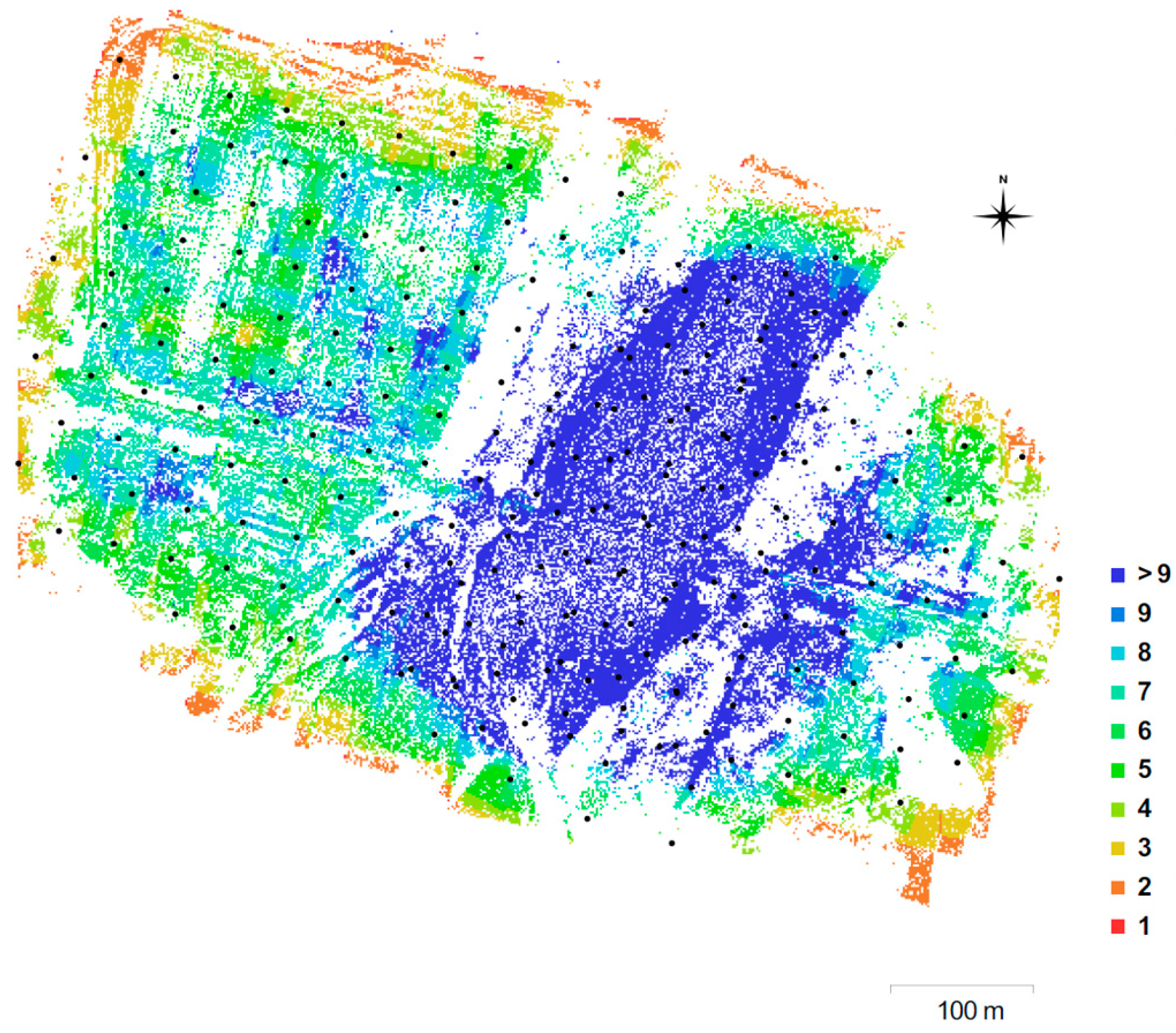
2.1. Test Site Description
2.2. Reference Network and GCP
2.3. Survey Flights
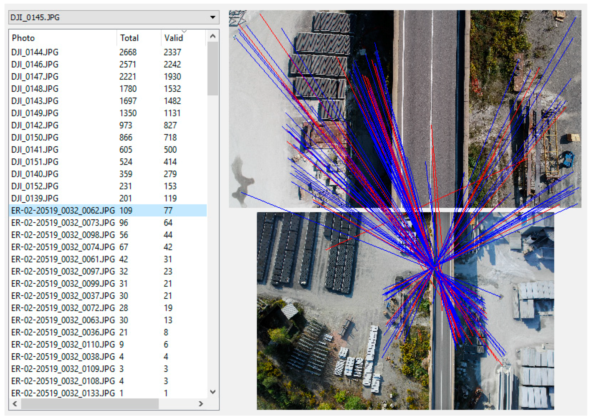
2.4. Photogrammetric Data Processing
2.5. Test Description
- eBeeprecal: the set of 18 images used for pre-calibration purposes, oriented with GNSS-AT and a variable number of GCP as control information;
- eBee: the eBee block with camera stations from GNSS RTK positioning as control information;
- eBeeOpt: the best (minimum) subset of the eBee block still ensuring block accuracy; camera stations are the only control information;
- P4 30: the single strip flown with the Phantom4 at 30 m relative elevation;
- + k GCP: the adjusted block includes k GCP;
- pre-c: the IO parameters are fixed to values obtained from an on-the-job pre-calibration;
- self-c: the IO parameters are estimated by self-calibration in the BBA.
3. Results
3.1. Comparison between Pre- and Self-eBee Camera Calibration (O1)
3.2. Accuracy of the Phantom4 30 m Strip Adjusted with GCP Only (O2)
3.3. Tie Points Across Master and Auxilary Blocks (O3)
3.4. Orientation Accuracy of the Master–Auxiliary Joint Block (O4)
3.5. Search for the Best Auxiliary Block Configuration (O5)
4. Discussion
5. Conclusions
Author Contributions
Funding
Acknowledgments
Conflicts of Interest
References
- Nex, F.; Remondino, F. UAV for 3D mapping applications: A review. Appl. Geomat. 2014, 6, 1–15. [Google Scholar] [CrossRef]
- Colomina, I.; Molina, P. Unmanned aerial systems for photogrammetry and remote sensing: A review. ISPRS J. Photogramm. Remote Sens. 2014, 92, 79–97. [Google Scholar] [CrossRef]
- Stöcker, C.; Bennett, R.; Nex, F.; Gerke, M.; Zevenbergen, J. Review of the Current State of UAV Regulations. Remote Sens. 2017, 9, 459. [Google Scholar] [CrossRef]
- Tonkin, T.N.; Midgley, N.G. Ground-Control Networks for Image Based Surface Reconstruction: An Investigation of Optimum Survey Designs Using UAV Derived Imagery and Structure-from-Motion Photogrammetry. Remote Sens. 2016, 8, 786. [Google Scholar] [CrossRef]
- Sanz-Ablanedo, E.; Chandler, J.H.; Rodríguez-Pérez, J.R.; Ordóñez, C. Accuracy of Unmanned Aerial Vehicle (UAV) and SfM Photogrammetry Survey as a Function of the Number and Location of Ground Control Points Used. Remote Sens. 2018, 10, 1606. [Google Scholar] [CrossRef]
- Agüera-Vega, F.; Carvajal-Ramírez, F.; Martínez-Carricondo, P.; López, J.S.-H.; Mesas-Carrascosa, F.J.; García-Ferrer, A.; Pérez-Porras, F.J. Reconstruction of extreme topography from UAV structure from motion photogrammetry. Measurement 2018, 121, 127–138. [Google Scholar] [CrossRef]
- Harwin, S.; Lucieer, A.; Osborn, J. The Impact of the Calibration Method on the Accuracy of Point Clouds Derived Using Unmanned Aerial Vehicle Multi-View Stereopsis. Remote Sens. 2015, 7, 11933–11953. [Google Scholar] [CrossRef]
- Eltner, A.; Kaiser, A.; Castillo, C.; Rock, G.; Neugirg, F.; Abellán, A. Image-based surface reconstruction in geomorphometry – merits, limits and developments. Earth Surf. Dyn. 2016, 4, 359–389. [Google Scholar] [CrossRef]
- Pagliari, D.; Rossi, L.; Passoni, D.; Pinto, L.; De Michele, C.; Avanzi, F. Measuring the volume of flushed sediments in a reservoir using multi-temporal images acquired with UAS. Geomat. Nat. Hazards Risk 2017, 8, 150–166. [Google Scholar] [CrossRef]
- Gindraux, S.; Boesch, R.; Farinotti, D. Accuracy Assessment of Digital Surface Models from Unmanned Aerial Vehicles’ Imagery on Glaciers. Remote Sens. 2017, 9, 186. [Google Scholar] [CrossRef]
- Forlani, G.; Dall’Asta, E.; Diotri, F.; Di Cella, U.M.; Roncella, R.; Santise, M. Quality Assessment of DSMs Produced from UAV Flights Georeferenced with On-Board RTK Positioning. Remote Sens. 2018, 10, 311. [Google Scholar] [CrossRef]
- Rusnák, M.; Sládek, J.; Kidová, A.; Lehotský, M. Template for high-resolution river landscape mapping using UAV technology. Measurement 2018, 115, 139–151. [Google Scholar] [CrossRef]
- Li, H.; Chen, L.; Wang, Z.; Yu, Z. Mapping of River Terraces with Low-Cost UAS Based Structure-from-Motion Photogrammetry in a Complex Terrain Setting. Remote Sens. 2019, 11, 464. [Google Scholar] [CrossRef]
- Hartley, R.; Zisserman, A. Multiple View Geometry in Computer Vision; Cambridge University Press: Cambridge, UK, 2003. [Google Scholar]
- Kraus, K. Photogrammetry, Volume 1: Fundamentals and Standard Processes; Dümmlers Verlag: Bonn, Germany, 1993. [Google Scholar]
- Jacobsen, K. Development of digital aerial cameras. In Proceedings of the ISPRS Istanbul Workshop 2010 on Modeling of Optical Airborne and Spaceborne Sensors, WG I/4, Istanbul, Turkey, 11–13 October 2010. [Google Scholar]
- Nesbit, P.R.; Hugenholtz, C.H. Enhancing UAV–SfM 3D Model Accuracy in High-Relief Landscapes by Incorporating Oblique Images. Remote Sens. 2019, 11, 239. [Google Scholar] [CrossRef]
- Danzi, M.; Di Crescenzo, G.; Ramondini, M.; Santo, A. Use of unmanned aerial vehicles (UAVs) for photogrammetric surveys in rockfall instability studies. Rend. Online Soc. Geol. Ital. 2013, 24, 82–85. [Google Scholar]
- Shahbazi, M.; Sohn, G.; Théau, J.; Menard, P. Uav-based point cloud generation for open-pit mine modelling. ISPRS Int. Arch. Photogramm. Remote Sens. Spat. Inf. Sci. 2015, 40, 313–320. [Google Scholar] [CrossRef]
- Wackrow, R.; Chandler, J.H. Minimising systematic error surfaces in digital elevation models using oblique convergent imagery. Photogramm. Rec. 2011, 26, 16–31. [Google Scholar] [CrossRef]
- Amrullah, C.; Suwardhi, D.; Meilano, I. Product accuracy effect of oblique and vertical non-metric digital camera utilization in uav-photogrammetry to determine fault plane. ISPRS Ann. Photogramm. Remote Sens. Spat. Inf. Sci. 2016, 3, 41–48. [Google Scholar] [CrossRef]
- Rossi, P.; Mancini, F.; Dubbini, M.; Mazzone, F.; Capra, A. Combining nadir and oblique UAV imagery to reconstruct quarry topography: Methodology and feasibility analysis. Eur. J. Remote Sens. 2017, 50, 211–221. [Google Scholar] [CrossRef]
- Luhmann, T.; Robson, S.; Kyle, S.; Boehm, J. Close-Range Photogrammetry and 3d Imaging, 2nd ed.; Walter de Gruyter: Berlin, Germany, 2014. [Google Scholar]
- Chen, S.; Li, Y.F.; Kwok, N.M. Active vision in robotic systems: A survey of recent developments. Int. J. Robot. Res. 2011, 30, 1343–1377. [Google Scholar] [CrossRef]
- Palazzolo, E.; Stachniss, C. Effective Exploration for MAVs Based on the Expected Information Gain. Drones 2018, 2, 9. [Google Scholar] [CrossRef]
- Carbonneau, P.E.; Dietrich, J.T. Cost-effective non-metric photogrammetry from consumer-grade sUAS: Implications for direct georeferencing of structure from motion photogrammetry. Earth Surf. Processes Landf. 2017, 42, 473–486. [Google Scholar] [CrossRef]
- Dji. Available online: https://www.dji.com/it/phantom-4-rtk/info#specs (accessed on 28 February 2019).
- Ackermann, F.; Schade, H. Application of GPS for aerial triangulation. Photogr. Eng. Remote Sens. 1993, 59, 1625–1632. [Google Scholar]
- Forlani, G.; Pinto, L. Experiences of combined block adjustment with GPS data. In Proceedings of the SPIE, ISPRS Commission III Symposium: Spatial Information from Digital Photogrammetry and Computer Vision, Munich, Germany, 5–9 September 1994; Heinrich, E., Christian, H., Konrad, E., Eds.; International Society for Optics and Photonics: Bellingham, WA, USA, 1994; pp. 219–226. [Google Scholar]
- Bilker, M.; Honkavaara, E.; Jaakkola, J. GPS supported Aerial Triangulation using untargeted ground control. Int. Arch. Photogramm. Remote Sens. 1998, 32–33/W1, 2–9. [Google Scholar]
- Heipke, C.; Jacobsen, K.; Wegmann, H.; Andersen, O.; Nilsen, B. Integrated sensor orientation-an OEEPE Test. Int. Arch. Photogramm. Remote Sens. 2000, XXXIII, 373–380. [Google Scholar]
- Rehak, M.; Skaloud, J. Fixed-wing micro aerial vehicle for accurate corridor mapping. In Proceedings of the ISPRS Annals of the Photogrammetry, Remote Sensing and Spatial Information Sciences, Toronto, ON, Canada, 30 August–2 September 2015; Volume XL-1/W4, pp. 23–31. [Google Scholar]
- Cucci, D.A.; Rehak, M.; Skaloud, J. Bundle adjustment with raw inertial observations in UAV applications. ISPRS J. Photogramm. Remote Sens. 2017, 130, 1–12. [Google Scholar] [CrossRef]
- James, M.R.; Robson, S. Mitigating systematic error in topographic models derived from UAV and ground-based image networks. Earth Surf. Processes Landf. 2014, 39, 1413–1420. [Google Scholar] [CrossRef]
- Oniga, V.-E.; Pfeifer, N.; Loghin, A.-M. 3D Calibration Test-Field for Digital Cameras Mounted on Unmanned Aerial Systems (UAS). Remote Sens. 2018, 10, 2017. [Google Scholar] [CrossRef]
- James, M.; Robson, S.; D’Oleire-Oltmanns, S.; Niethammer, U. Optimising UAV topographic surveys processed with structure-from-motion: Ground control quality, quantity and bundle adjustment. Geomorphology 2017, 280, 51–66. [Google Scholar] [CrossRef]
- Daakir, M.; Pierrot-Deseilligny, M.; Bosser, P.; Pichard, F.; Thom, C.; Rabot, Y. Study of lever-arm effect using embedded photogrammetry and on-board GPS receiver on UAV for metrological mapping purpose and proposal of a free ground measurements calibration procedure. In Proceedings of the International Archives of the Photogrammetry, Remote Sensing and Spatial Information Sciences, 2016 EuroCOW 2016, the European Calibration and Orientation Workshop, Lausanne, Switzerland, 10–12 February 2016; Volume XL-3/W4, pp. 65–70. [Google Scholar]
- Cramer, M.; Stallmann, D.; Haala, N. Direct georeferencing using GPS/inertial exterior orientations for photogrammetric applications. Int. Arch. Photogramm. Remote Sens. 2000, XXXIII, 198–205. [Google Scholar]
- Cramer, M.; Przybilla, H.-J.; Zurhorst, A. UAV cameras: Overview and geometric calibration benchmark. ISPRS Int. Arch. Photogramm. Remote Sens. Spat. Inf. Sci. 2017, 42, 85–92. [Google Scholar] [CrossRef]
- Benassi, F.; Dall’Asta, E.; Diotri, F.; Forlani, G.; Di Cella, U.M.; Roncella, R.; Santise, M. Testing Accuracy and Repeatability of UAV Blocks Oriented with GNSS-Supported Aerial Triangulation. Remote Sens. 2017, 9, 172. [Google Scholar] [CrossRef]
- Zhou, Y.; Rupnik, E.; Faure, P.-H.; Pierrot-Deseilligny, M. GNSS-Assisted Integrated Sensor Orientation with Sensor Pre-Calibration for Accurate Corridor Mapping. Sensors 2018, 18, 2783. [Google Scholar] [CrossRef] [PubMed]
- Cook, K.L. An evaluation of the effectiveness of low-cost UAVs and structure from motion for geomorphic change detection. Geomorphology 2017, 278, 195–208. [Google Scholar] [CrossRef]
- Marzolff, I.; Poesen, J. The potential of 3D gully monitoring with GIS using high-resolution aerial photography and a digital photogrammetry system. Geomorphology 2009, 111, 48–60. [Google Scholar] [CrossRef]
- Adams, M.S.; Fromm, R.; Lechner, V. High-resolution debris flow volume mapping with unmanned aerial systems (UAS) and photogrammetric techniques. In Proceedings of the International Archives of the Photogrammetry, Remote Sensing and Spatial Information Sciences, 2016 XXIII ISPRS Congress, Prague, Czech, 12–19 July 2016; Volume XLI-B1, pp. 749–755. [Google Scholar]
- Blazquez, M.; Colomina, I. Relative INS/GNSS aerial control in integrated sensor orientation: Models and performance. ISPRS J. Photogramm. Remote Sens. 2012, 67, 120–133. [Google Scholar] [CrossRef]
- Skaloud, J.; Rehak, M.; Lichti, D. Mapping with MAV: Experimental Study on the Contribution of Absolute and Relative Aerial Position Control. ISPRS Int. Arch. Photogramm. Remote Sens. Spat. Inf. Sci. 2014, 40, 123–129. [Google Scholar] [CrossRef]
- Hugenholtz, C.; Brown, O.; Walker, J.; Barchyn, T.; Nesbit, P.; Kucharczyk, M.; Myshak, S. Spatial Accuracy of UAV-Derived Orthoimagery and Topography: Comparing Photogrammetric Models Processed with Direct Geo-Referencing and Ground Control Points. Geomatica 2016, 70, 21–30. [Google Scholar] [CrossRef]
- Jozkow, G.; Toth, C. Georeferencing experiments with UAS imagery. ISPRS Ann. Photogramm. Remote Sens. Spat. Inf. Sci. 2014, 2, 25–29. [Google Scholar] [CrossRef]
- Mian, O.; Lutes, J.; Lipa, G.; Hutton, J.J.; Gavelle, E.; Borghini, S. Direct georeferencing on small unmanned aerial platforms for improved reliability and accuracy of mapping without the need for ground control points. ISPRS Int. Arch. Photogramm. Remote Sens. Spat. Inf. Sci. 2015, 40, 397–402. [Google Scholar] [CrossRef]
- Gerke, M.; Przybilla, H.J. Accuracy Analysis of Photogrammetric UAV Image Blocks: Influence of on board RTKGNSS and Cross Flight Patterns. Photogramm. Fernerkund. Geoinf. 2016, 1, 17–30. [Google Scholar] [CrossRef]
- James, M.R.; Robson, S.; Smith, M.W. 3-D uncertainty-based topographic change detection with structure-from-motion photogrammetry: Precision maps for ground control and directly georeferenced surveys. Earth Surf. Processes Landf. 2017, 42, 1769–1788. [Google Scholar] [CrossRef]


| Flight | Flight Height (m) AGL | GSD (cm) | Overlap F–S (%) | # Images | Start–End Local Time |
|---|---|---|---|---|---|
| Ph4 30m | 32 | 0.9 | 82 (avg.) | 155 | 12:13–12:39 |
| Ph4 70m | 75 | 2.1 | 86 (avg.) | 76 | 12:40–12:55 |
| eBee EW | 97 | 2.2 | 50–70 | 177 | 14:52–15:05 |
| eBee NS | 105 | 2.4 | 55–75 | 69 | 15:32–15:37 |
| Obj. | Test Id | eBee cal | P4 cal | # GCP | # CP | Notes |
|---|---|---|---|---|---|---|
| O1 | eBeeprecal | self-c | n.a. | 1 or 12 | 9 or none | 18-image calibration block; three single-GCP calibrations and one 12-GCP calibration |
| O1 | eBee | pre-c | n.a. | 0 | 60 | four tests, each with a different set of pre-cal parameters |
| O1 | eBee +1GCP | self-c | n.a. | 1 | 59 | three self-calibrations with single-GCP at mid bridge or at bridge ends |
| O2 | P4 30 + 17 GCP | n.a. | self-c | 17 | 27 | traditional adjustment with GCP |
| O4 | eBee + P4 30 | pre-c | self-c | 0 | 44 | full eBee block |
| O4 | eBee + P4 30 + 1GCP | self-c | self-c | 1 | 43 | full eBee block; single-GCP at mid bridge or at bridge ends |
| O5 | eBeeOpt + P4 30 | pre-c | self-c | 0 | 44 | eBee longitudinal and cross strip progressively removed |
| Parameter | 12 GCP | GCP 706 | GCP 707 | GCP 713 |
|---|---|---|---|---|
| f | 4401.43 | 4400.79 | 4400.49 | 4399.679 |
| cx | −70.17 | −70.34 | −70.31 | −70.37 |
| cy | 0.34 | 0.19 | 0.40 | 0.71 |
| b1 | 1.85 | 1.75 | 1.81 | 1.80 |
| b2 | −0.52 | −0.52 | −0.50 | −0.51 |
| k1 | 3.176 × 10⁻² | 3.212 × 10⁻² | 3.195 × 10⁻² | 3.187 × 10⁻² |
| k2 | −1.928 × 10⁻¹ | −1.937 × 10⁻¹ | −1.937 × 10⁻¹ | −1.935 × 10⁻¹ |
| k3 | 2.863 × 10⁻¹ | 2.880 × 10⁻¹ | 2.878 × 10⁻¹ | 2.874 × 10⁻¹ |
| p1 | −5.474 × 10⁻³ | −5.488 × 10⁻³ | −5.488 × 10⁻³ | −5.489 × 10⁻³ |
| p2 | 7.559 × 10⁻⁴ | 6.850 × 10⁻⁴ | 7.308 × 10⁻⁴ | 7.430 × 10⁻⁴ |
| RMSE X (cm) | n.a. | 1.9 | 2.5 | 2.5 |
| RMSE Y (cm) | n.a. | 1.6 | 2.1 | 3.0 |
| RMSE Z (cm) | n.a. | 3.3 | 1.8 | 1.4 |
| eBee Camera Calibration Parameters from: | GCP Location | GCP Fixed | RMSE X (cm) | RMSE Y (cm) | RMSE Z (cm) |
|---|---|---|---|---|---|
| Pre-c with GCP 713 | n.a. | none | 1.3 | 1.7 | 3.8 |
| Pre-c with GCP 707 | n.a. | none | 1.3 | 1.7 | 2.6 |
| Pre-c with GCP 706 | n.a. | none | 1.2 | 1.5 | 2.7 |
| Pre-c with 12GCP | n.a. | none | 1.3 | 1.7 | 2.2 |
| Self-c | mid bridge | GCP 713 | 1.3 | 1.5 | 3.0 |
| Self-c | mid bridge | GCP 707 | 1.3 | 1.5 | 2.8 |
| Self-c | mid bridge | GCP 706 | 1.3 | 1.5 | 2.7 |
| Self-c | bridge west end | GCP A721 | 1.3 | 1.3 | 2.7 |
| Self-c | bridge east end | GCP BS484 | 1.4 | 1.7 | 2.8 |
| Self-c | n.a. | none | 1.6 | 1.5 | 5.7 |
| Calibration Parameters from | RMSE X (cm) | RMSE Y (cm) | RMSE Z (cm) |
|---|---|---|---|
| Pre-c joint P4 30 + P4 70 strips | 1.2 | 1.4 | 1.8 |
| Self-c | 1.2 | 1.5 | 2.1 |
| eBee Camera Calibration Parameters from: | GCP Location | GCP Fixed | RMSE X (cm) | RMSE Y (cm) | RMSE Z (cm) |
|---|---|---|---|---|---|
| Pre-c GCP 713 | n.a. | none | 2.3 | 2.0 | 3.4 |
| Pre-c GCP 707 | n.a. | none | 2.0 | 2.0 | 2.4 |
| Pre-c GCP 706 | n.a. | none | 1.5 | 1.6 | 2.3 |
| Pre-c 12GCP | n.a. | none | 2.2 | 2.0 | 2.8 |
| Self-c | mid bridge | GCP 713 | 2.1 | 2.0 | 3.0 |
| Self-c | mid bridge | GCP 707 | 1.9 | 1.9 | 2.3 |
| Self-c | mid bridge | GCP 706 | 1.2 | 1.3 | 2.6 |
| Self-c | bridge west end | GCP A721 | 1.5 | 1.8 | 4.5 |
| Self-c | bridge east end | GCP BS484 | 1.5 | 1.8 | 4.5 |
| Self-c | n.a. | none | 1.5 | 1.8 | 11.5 |
© 2019 by the authors. Licensee MDPI, Basel, Switzerland. This article is an open access article distributed under the terms and conditions of the Creative Commons Attribution (CC BY) license (http://creativecommons.org/licenses/by/4.0/).
Share and Cite
Forlani, G.; Diotri, F.; Cella, U.M.d.; Roncella, R. Indirect UAV Strip Georeferencing by On-Board GNSS Data under Poor Satellite Coverage. Remote Sens. 2019, 11, 1765. https://doi.org/10.3390/rs11151765
Forlani G, Diotri F, Cella UMd, Roncella R. Indirect UAV Strip Georeferencing by On-Board GNSS Data under Poor Satellite Coverage. Remote Sensing. 2019; 11(15):1765. https://doi.org/10.3390/rs11151765
Chicago/Turabian StyleForlani, Gianfranco, Fabrizio Diotri, Umberto Morra di Cella, and Riccardo Roncella. 2019. "Indirect UAV Strip Georeferencing by On-Board GNSS Data under Poor Satellite Coverage" Remote Sensing 11, no. 15: 1765. https://doi.org/10.3390/rs11151765
APA StyleForlani, G., Diotri, F., Cella, U. M. d., & Roncella, R. (2019). Indirect UAV Strip Georeferencing by On-Board GNSS Data under Poor Satellite Coverage. Remote Sensing, 11(15), 1765. https://doi.org/10.3390/rs11151765