Improvement of EPIC/DSCOVR Image Registration by Means of Automatic Coastline Detection
Abstract
1. Introduction
2. Methodology
2.1. Mathematical Description
- The center of distortion and the center of rotation are assumed identical, i.e., and .
- The center of distortion/rotation is assumed to be known and located at the center of the image.
- Compute the vector at iteration k aswhere denotes the Jacobian matrix of with respect to the state vector at iteration k:
- Compute the regularised generalised inverse at iteration k by means of generalised singular value decomposition:
- Compute the state vector for the next iteration :
- Check the convergence criteria. If any is passed, set and exit; otherwise, go to Step 1 for iteration . We use the following convergence criteria:
- X-convergence criterion: , where is a predefined tolerance value.
- S-convergence criterion: , where is a predefined tolerance value and is the squared residual sum at iteration k.
- Define an a priori state vector with no shift, and compute the optimal state vector by applying Tikhonov least squares minimisation with and as fixed parameters.
- Use from the previous step as the new a priori state vector , and compute the optimal state vector by applying Tikhonov least squares minimisation with no fixed parameters.
- The analysis of the Jacobian matrices at the first iteration by means of the generalised singular value decomposition shows that is an appropriate value for the regularisation parameter.
- The regularisation matrix is defined as a diagonal matrix,where, for every parameter, we denote by its expected dispersion, and we denote by a weighting factor that determines its freedom in the retrieval, so that implies total freedom and fixes the parameter to the a priori solution [25]. Based on the expected dispersions of the state vector components, which are set asthe optimal weights have to be found empirically by performing a set of retrievals with synthetic data, ensuring that the state vector components stay within the valid ranges around the a priori solution. For our case, the following optimal values are found:thereby implying total freedom for and reduced freedom for .
- The first a priori state vector is set with the following initial guesses for the rotation angle and the radial distortion parameter:
2.2. Detection of Matching Coastline Features
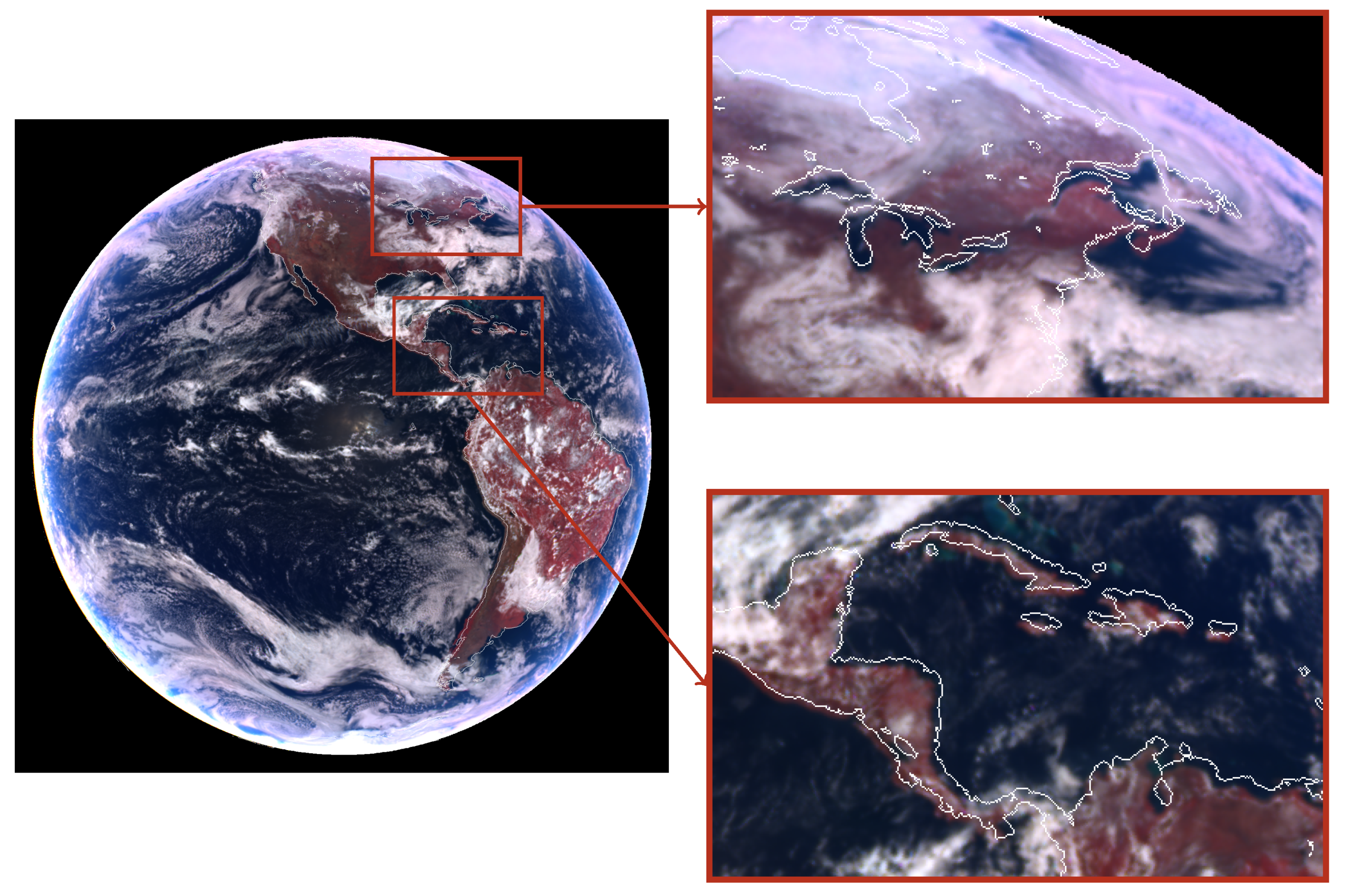
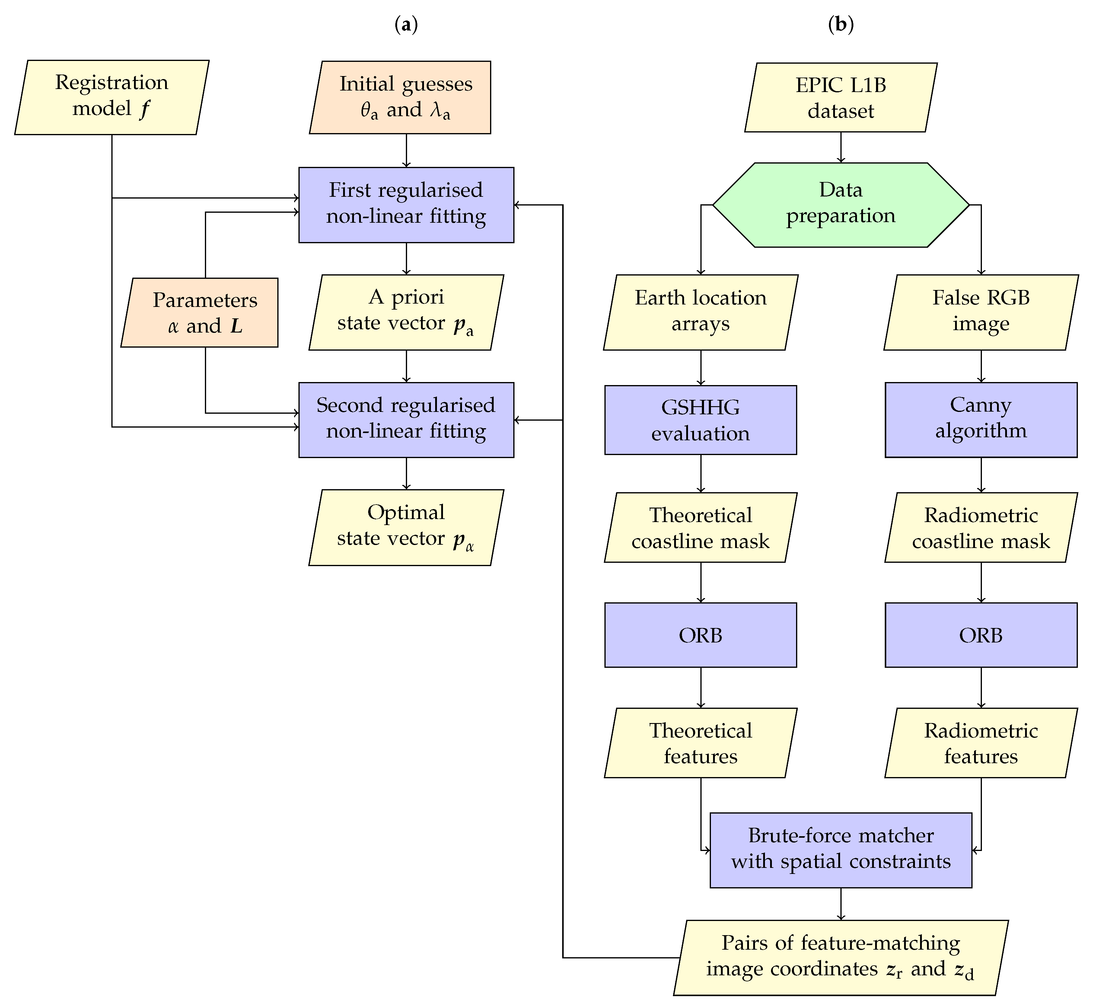
- Create a mask with the theoretical coastline, i.e., that inferred from the arrays of Earth coordinates.
- Create a mask with the radiometric coastline, i.e., that inferred from the actual image.
- Find pairs of common features from both coastline masks by using computer vision techniques.
2.2.1. Computation of the Theoretical Coastline
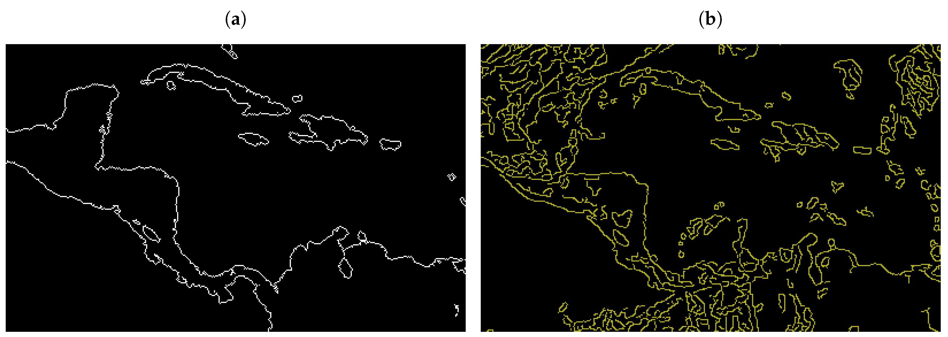
- Create the theoretical land mask by checking for every image pixel if its (latitude, longitude) pair is contained inside a land polygon from the low-resolution GSHHG (Global Self-consistent, Hierarchical, High-resolution Geography database) [26].
- Apply one morphological binary erosion to the theoretical land mask with a flat diamond shaped structuring element of dimensions [27].
- Compute the theoretical coastline mask as the result of the bitwise operator XOR on the original and eroded theoretical land masks.
2.2.2. Computation of the Radiometric Coastline
- Convert the image channel with the highest contrast between land and water into 8-bit form (i.e., the false-red channel, which corresponds to the 779.5 nm EPIC channel).
- Compute the median value v from the Earth pixels of this 8-bit image.
- Compute the radiometric coastline mask by applying the Canny edge detection algorithm [28] on the previous 8-bit image with hysteresis thresholding parameters given bywhere is an argument that controls the separation between both thresholds [29] and its value is found empirically: if is small, only the strong borders are preserved; if is big, both strong and weak borders are kept. For our purpose, we found that is a good compromise.
2.2.3. Matching of Coastline Features
- Detect keypoints (e.g., edges, corners, and regions of interest) in the compared images.
- Describe every keypoint by a descriptor vector with information from its neighbourhood.
- Match keypoint pairs based on the similarity of their descriptor vectors.
- The ORB detector is a modified version of the keypoint detector FAST (Features from Accelerated Segment Test) [35]. In addition to the original FAST, it also computes the orientation angle of the detected keypoints.
- The ORB descriptor is a modified version of the descriptor BRIEF (Binary Robust Independent Elementary Features) [36]. The binary descriptor vector generated by the original BRIEF shows problems when identifying matching keypoints under rotation conditions; ORB fixes the issue taking into consideration the orientation computed by the ORB detector.
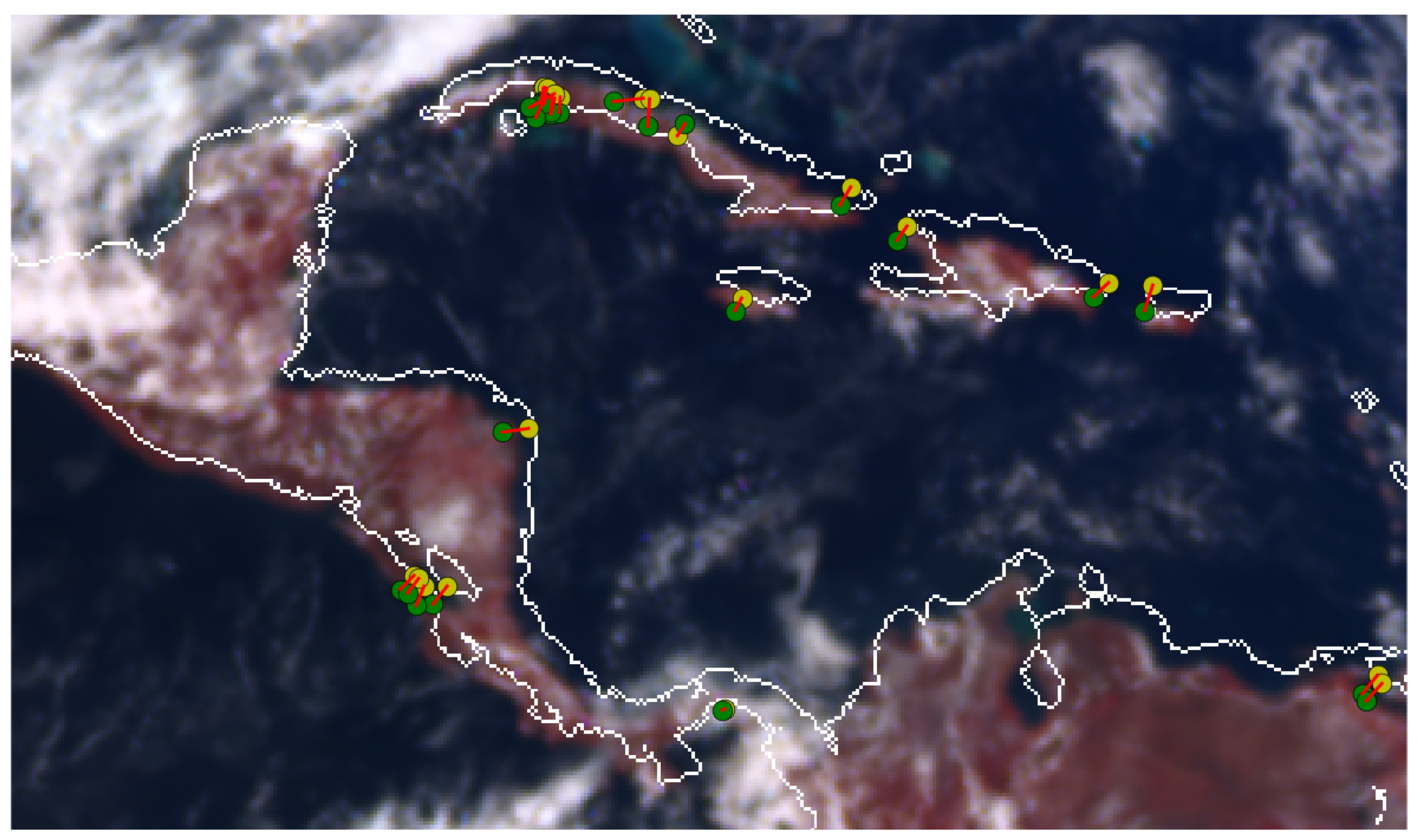
- Compute the Hamming distance (i.e., the number of positions at which the corresponding values of arrays are different [38]) from to every radiometric keypoint , , aswhere is the length of the binary descriptor vectors, ⊕ is the XOR operator, and and denote the mth components of the descriptor vectors and , respectively.
- Select the radiometric keypoint with minimum Hamming distance to as the matching candidate for the theoretical keypoint , where
- For the given radiometric keypoint , compute its Hamming distance to every theoretical keypoint , , as
- The pair is a valid matching pair only if is the theoretical keypoint with minimum Hamming distance to , otherwise the pair is discarded, i.e., it is valid only if
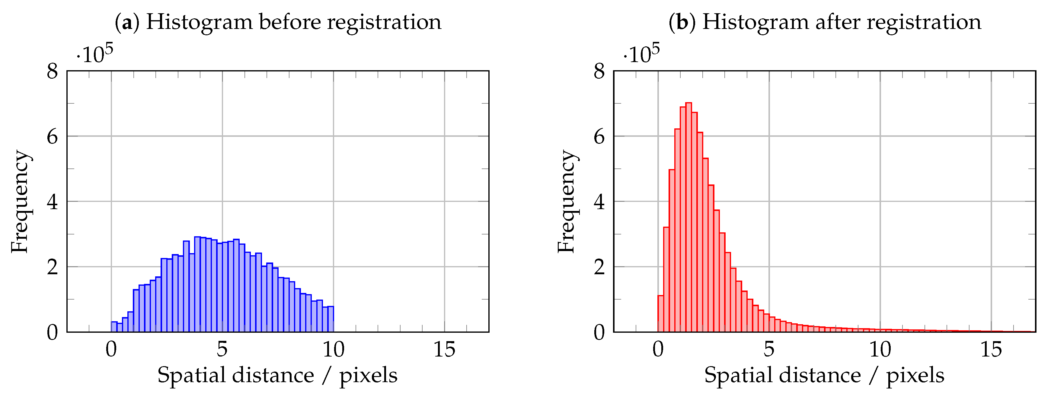
- The spatial distance between a theoretical keypoint and the theoretical coastline.
- The spatial distance between the keypoints of a matching pair .
3. Results
- The performance of the non-linearised fitting procedure in reducing the spatial distance between the image coordinates from matching theoretical and radiometric features.
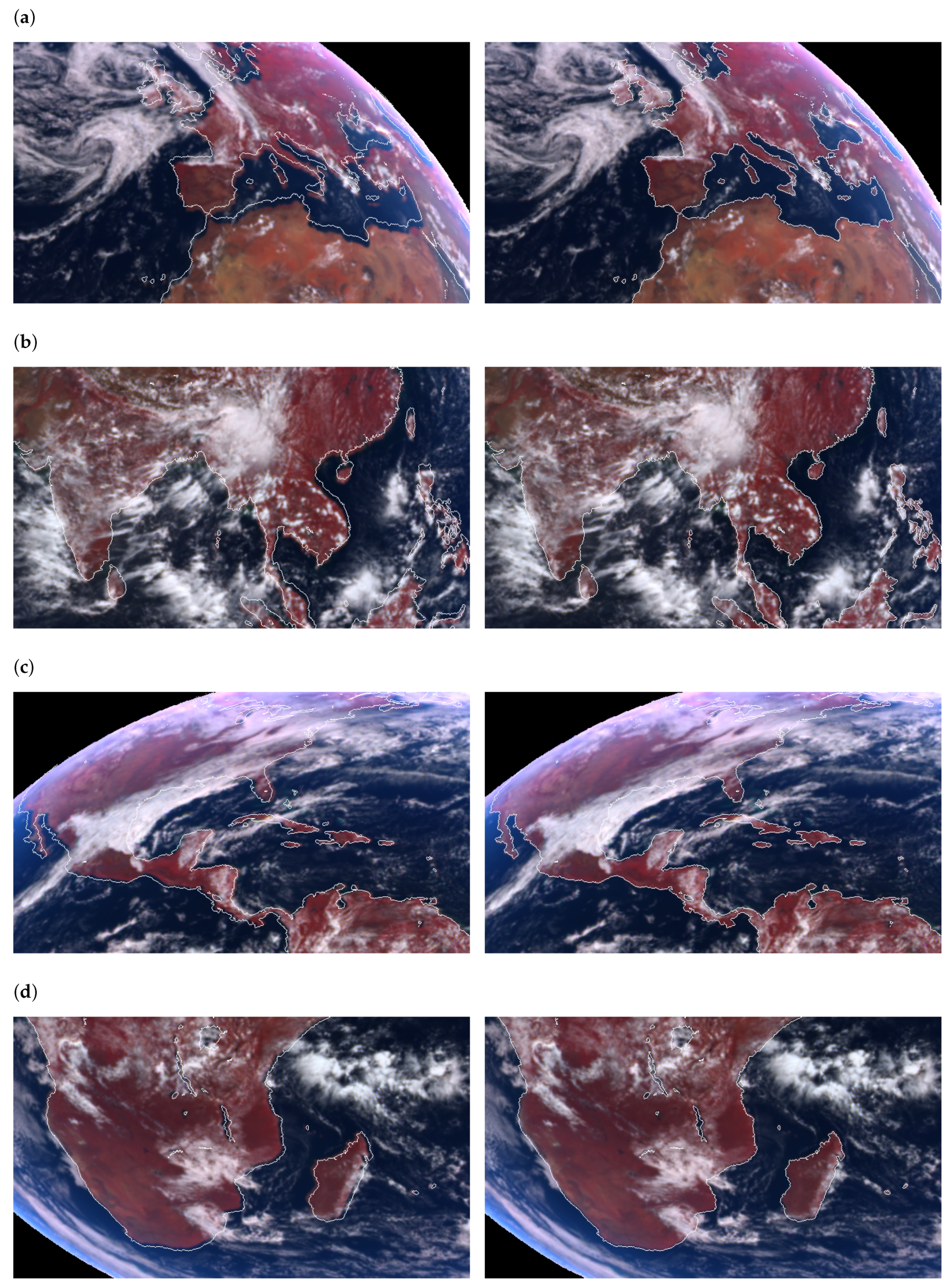
- The global impact of this correction procedure on the image registration quality.
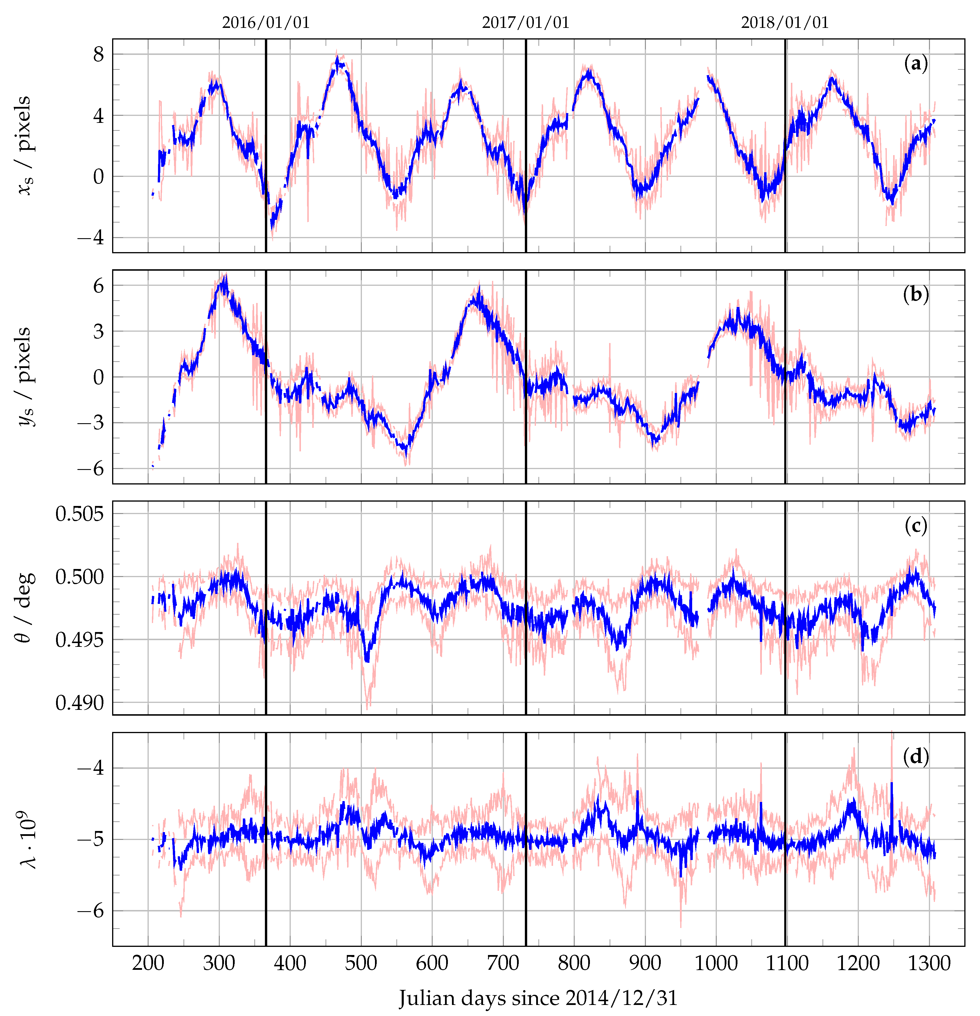
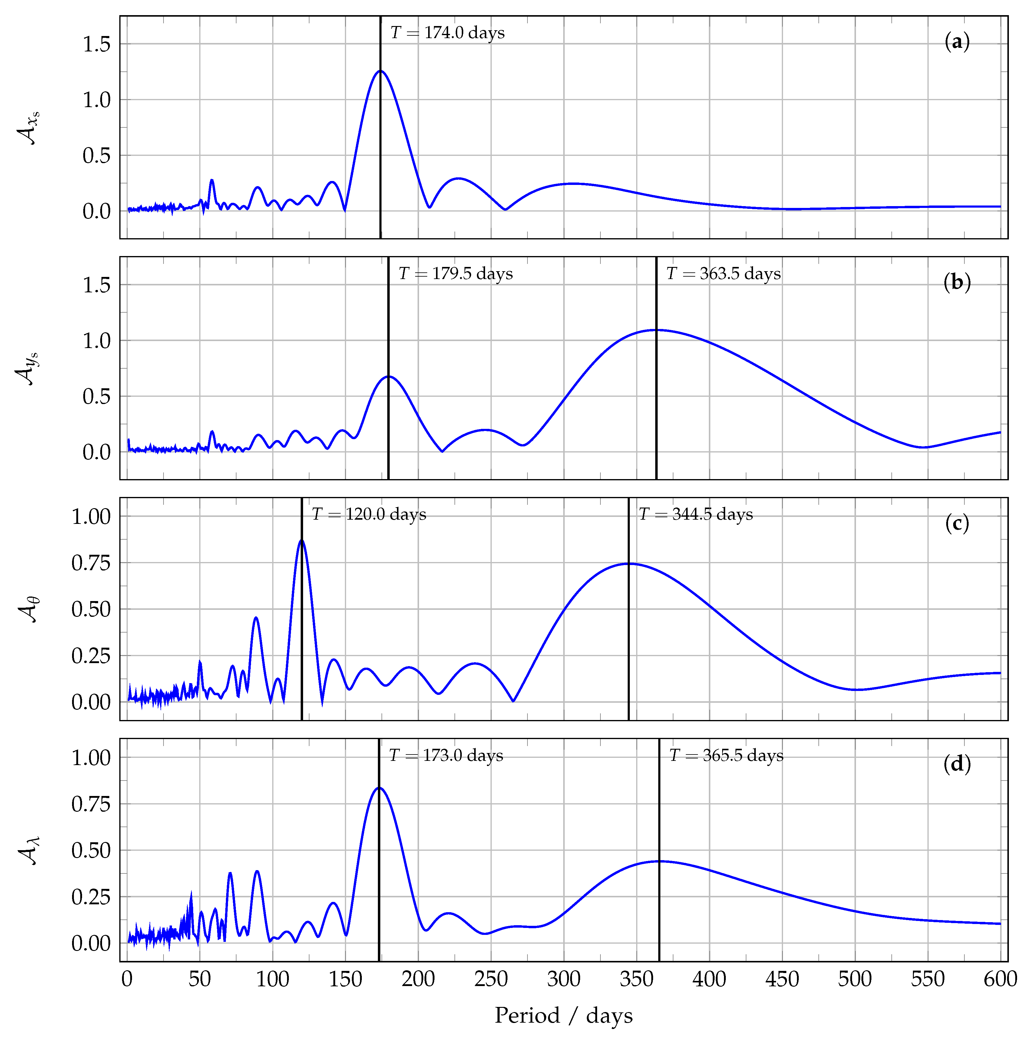
- The behaviour of the retrieved transformation parameters as a function of time.
4. Conclusions
Author Contributions
Funding
Acknowledgments
Conflicts of Interest
Abbreviations
| BRIEF | Binary Robust Independent Elementary Features |
| CCD | Charge-Coupled Device |
| DSCOVR | Deep Space Climate Observatory |
| EPIC | Earth Polychromatic Imaging Camera |
| FAST | Features from Accelerated Segment Test |
| GEMS | Geostationary Environment Monitoring Spectrometer |
| GSHHG | Global Self-consistent Hierarchical, High-resolution Geography database |
| L1B | Level 1B |
| MERIS | MEdium Resolution Imaging Spectrometer |
| NASA | National Aeronautics and Space Administration |
| ORB | Oriented FAST and Rotated BRIEF |
| RANSAC | RANdom SAmple Consensus |
| RGB | Red Green Blue |
| SIFT | Scale-Invariant Feature Transform |
| SURF | Speeded-Up Robust Features |
| TEMPO | Tropospheric Emissions: Monitoring of POllution |
| UVN | Ultraviolet-Visible-Near-infrared |
References
- Marshak, A.; Herman, J.; Szabo, A.; Blank, K.; Carn, S.; Cede, A.; Geogdzhayev, I.; Huang, D.; Huang, L.K.; Knyazikhin, Y.; et al. Earth Observations from DSCOVR EPIC Instrument. Bull. Am. Meteorol. Soc. 2018, 99, 1829–1850. [Google Scholar] [CrossRef] [PubMed]
- Marshak, A.; Knyazikhin, Y. The spectral invariant approximation within canopy radiative transfer to support the use of the EPIC/DSCOVR oxygen B-band for monitoring vegetation. J. Quant. Spectrosc. Radiat. Transf. 2017, 191, 7–12. [Google Scholar] [CrossRef] [PubMed]
- Herman, J.; Huang, L.; McPeters, R.; Ziemke, J.; Cede, A.; Blank, K. Synoptic ozone, cloud reflectivity, and erythemal irradiance from sunrise to sunset for the whole earth as viewed by the DSCOVR spacecraft from the earth–sun Lagrange 1 orbit. Atmos. Meas. Tech. 2018, 11, 177–194. [Google Scholar] [CrossRef]
- Carn, S.A.; Krotkov, N.A.; Fisher, B.L.; Li, C.; Prata, A.J. First observations of volcanic eruption clouds from the L1 Earth-Sun Lagrange point by DSCOVR/EPIC. Geophys. Res. Lett. 2018, 45, 11456–11464. [Google Scholar] [CrossRef]
- Efremenko, D.S.; Loyola, R.D.G.; Hedelt, P.; Spurr, R.J.D. Volcanic SO2 plume height retrieval from UV sensors using a full-physics inverse learning machine algorithm. Int. J. Remote Sens. 2017, 38, 1–27. [Google Scholar] [CrossRef]
- Xu, X.; Wang, J.; Wang, Y.; Zeng, J.; Torres, O.; Yang, Y.; Marshak, A.; Reid, J.; Miller, S. Passive remote sensing of altitude and optical depth of dust plumes using the oxygen A and B bands: First results from EPIC/DSCOVR at Lagrange-1 point. Geophys. Res. Lett. 2017, 44, 7544–7554. [Google Scholar] [CrossRef]
- Natraj, V.; Jiang, J.H.; Doicu, A.; Loyola, D.; Kopparla, P.; Yung, Y.L. Aerosol retrievals from DSCOVR measurements. In Proceedings of the IGARSS 2018—2018 IEEE International Geoscience and Remote Sensing Symposium, Valencia, Spain, 22–27 July 2018; pp. 6026–6028. [Google Scholar] [CrossRef]
- Yang, Y.; Meyer, K.; Wind, G.; Zhou, Y.; Marshak, A.; Platnick, S.; Min, Q.; Davis, A.B.; Joiner, J.; Vasilkov, A.; et al. Cloud products from the Earth Polychromatic Imaging Camera (EPIC): Algorithms and initial evaluation. Atmos. Meas. Tech. 2019, 12, 2019–2031. [Google Scholar] [CrossRef]
- Davis, A.B.; Merlin, G.; Cornet, C.; Labonnote, L.C.; Riédi, J.; Ferlay, N.; Dubuisson, P.; Min, Q.; Yang, Y.; Marshak, A. Cloud information content in EPIC/DSCOVR’s oxygen A- and B-band channels: An optimal estimation approach. J. Quant. Spectrosc. Radiat. Transf. 2018, 216, 6–16. [Google Scholar] [CrossRef]
- Davis, A.B.; Ferlay, N.; Libois, Q.; Marshak, A.; Yang, Y.; Min, Q. Cloud information content in EPIC/DSCOVR’s oxygen A- and B-band channels: A physics-based approach. J. Quant. Spectrosc. Radiat. Transf. 2018, 220, 84–96. [Google Scholar] [CrossRef]
- Gao, M.; Zhai, P.W.; Yang, Y.; Hu, Y. Cloud remote sensing with EPIC/DSCOVR observations: A sensitivity study with radiative transfer simulations. J. Quant. Spectrosc. Radiat. Transf. 2019, 230, 56–60. [Google Scholar] [CrossRef]
- Marquardt, D.W. An algorithm for least-squares estimation of nonlinear parameters. J. Soc. Ind. Appl. Math. 1963, 11, 431–441. [Google Scholar] [CrossRef]
- Tikhonov, A.N.; Arsenin, V.I. Solutions of Ill-Posed Problems; Scripta Series in Mathematics; Winston & Sons: Washington, DC, USA, 1977. [Google Scholar]
- Molina García, V.; Sasi, S.; Efremenko, D.S.; Doicu, A.; Loyola, D. Radiative transfer models for retrieval of cloud parameters from EPIC/DSCOVR measurements. J. Quant. Spectrosc. Radiat. Transf. 2018, 213, 228–240. [Google Scholar] [CrossRef]
- Molina García, V.; Sasi, S.; Efremenko, D.S.; Doicu, A.; Loyola, D. Linearized radiative transfer models for retrieval of cloud parameters from EPIC/DSCOVR measurements. J. Quant. Spectrosc. Radiat. Transf. 2018, 213, 241–251. [Google Scholar] [CrossRef]
- Efremenko, D.; Doicu, A.; Loyola, D.; Trautmann, T. Acceleration techniques for the discrete ordinate method. J. Quant. Spectrosc. Radiat. Transf. 2013, 114, 73–81. [Google Scholar] [CrossRef]
- Efremenko, D.S.; Doicu, A.; Loyola, D.; Trautmann, T. Fast stochastic radiative transfer models for trace gas and cloud property retrievals under cloudy conditions. In Springer Series in Light Scattering; Springer International Publishing: Basel, Switzerland, 2018; pp. 231–277. [Google Scholar]
- del Águila, A.; Efremenko, D.S.; Molina García, V.; Xu, J. Analysis of two dimensionality reduction techniques for fast simulation of the spectral radiances in the Hartley-Huggins band. Atmosphere 2019, 10, 142. [Google Scholar] [CrossRef]
- Blank, K. EPIC Geolocation and Color Imagery Algorithm Revision 5. Technical Report; 2017. Available online: https://eosweb.larc.nasa.gov/project/dscovr/DSCOVR_EPIC_Geolocation_V02.pdf (accessed on 23 July 2019).
- Haney, C.; Doelling, D.; Minnis, P.; Bhatt, R.; Scarino, B.; Gopalan, A. The calibration of the DSCOVR EPIC multiple visible channel instrument using MODIS and VIIRS as a reference. In Proceedings of the Earth Observing Systems XXI, San Diego, CA, USA, 28 August–1 September 2016. [Google Scholar] [CrossRef]
- Available online: https://search.earthdata.nasa.gov (accessed on 27 May 2019).
- Geogdzhayev, I.V.; Marshak, A. Calibration of the DSCOVR EPIC visible and NIR channels using MODIS Terra and Aqua data and EPIC lunar observations. Atmos. Meas. Tech. 2018, 11, 359–368. [Google Scholar] [CrossRef]
- Fitzgibbon, A.W. Simultaneous linear estimation of multiple view geometry and lens distortion. In Proceedings of the 2001 IEEE Computer Society Conference on Computer Vision and Pattern Recognition (CVPR 2001), Kauai, HI, USA, 8–14 December 2001; pp. 125–132. [Google Scholar] [CrossRef]
- Wang, A.; Qiu, T.; Shao, L. A simple method of radial distortion correction with centre of distortion estimation. J. Math. Imaging Vis. 2009, 35, 165–172. [Google Scholar] [CrossRef]
- Doicu, A.; Trautmann, T.; Schreier, F. Numerical Regularization for Atmospheric Inverse Problems; Springer: Berlin/Heidelberg, Germany, 2010. [Google Scholar]
- Wessel, P.; Smith, W.H.F. A global, self-consistent, hierarchical, high-resolution shoreline database. J. Geophys. Res. Solid Earth 1996, 101, 8741–8743. [Google Scholar] [CrossRef]
- Serra, J. Introduction to mathematical morphology. Comput. Vis. Graph. Image Process. 1986, 35, 283–305. [Google Scholar] [CrossRef]
- Canny, J. A computational approach to edge detection. IEEE Trans. Pattern Anal. Mach. Intell. 1986, 8, 679–698. [Google Scholar] [CrossRef]
- Available online: https://www.pyimagesearch.com/2015/04/06/zero-parameter-automatic-canny-edge-detection-with-python-and-opencv (accessed on 11 July 2019).
- Remondino, F.; Spera, M.G.; Nocerino, E.; Menna, F.; Nex, F. State of the art in high density image matching. Photogramm. Rec. 2014, 29, 144–166. [Google Scholar] [CrossRef]
- Lowe, D.G. Distinctive image features from scale-invariant keypoints. Int. J. Comput. Vis. 2004, 60, 91–110. [Google Scholar] [CrossRef]
- Bay, H.; Ess, A.; Tuytelaars, T.; Van Gool, L. Speeded-up robust features (SURF). Comput. Vis. Image Underst. 2008, 110, 346–359. [Google Scholar] [CrossRef]
- Rublee, E.; Rabaud, V.; Konolige, K.; Bradski, G. ORB: An efficient alternative to SIFT or SURF. In Proceedings of the 2011 International Conference on Computer Vision, Barcelona, Spain, 6–13 November 2011; pp. 2564–2571. [Google Scholar] [CrossRef]
- Kaehler, A.; Bradski, G. Learning OpenCV 3: Computer Vision in C++ with the OpenCV Library; O’Reilly Media: Sebastopol, CA, USA, 2016. [Google Scholar]
- Rosten, E.; Porter, R.; Drummond, T. Faster and better: A machine learning approach to corner detection. IEEE Trans. Pattern Anal. Mach. Intell. 2010, 32, 105–119. [Google Scholar] [CrossRef] [PubMed]
- Calonder, M.; Lepetit, V.; Ozuysal, M.; Trzcinski, T.; Strecha, C.; Fua, P. BRIEF: Computing a local binary descriptor very fast. IEEE Trans. Pattern Anal. Mach. Intell. 2012, 34, 1281–1298. [Google Scholar] [CrossRef]
- Available online: https://docs.opencv.org/3.0-beta/doc/py_tutorials/py_feature2d/py_matcher/py_matcher.html (accessed on 11 July 2019).
- Hamming, R. Error detecting and error correcting codes. Bell Syst. Tech. J. 1950, 29, 147–160. [Google Scholar] [CrossRef]
- Fischler, M.A.; Bolles, R.C. Random sample consensus: A paradigm for model fitting with applications to image analysis and automated cartography. Commun. ACM 1981, 24, 381–395. [Google Scholar] [CrossRef]
- Lomb, N. Least-squares frequency analysis of unequally spaced data. Astrophys. Space Sci. 1976, 39, 447–462. [Google Scholar] [CrossRef]
- Scargle, J. Studies in astronomical time series analysis. II - Statistical aspects of spectral analysis of unevenly spaced data. Astrophys. J. 1982, 263, 835–853. [Google Scholar] [CrossRef]
- Hocke, K. Phase estimation with the Lomb-Scargle periodogram method. Annal. Geophys. 1998, 16, 356–358. [Google Scholar]
- Jiang, J.H.; Zhai, A.J.; Herman, J.; Zhai, C.; Hu, R.; Su, H.; Natraj, V.; Li, J.; Xu, F.; Yung, Y.L. Using Deep Space Climate Observatory measurements to study the Earth as an exoplanet. Astron. J. 2018, 156, 26. [Google Scholar] [CrossRef]
- Van Herk, M. Image registration using Chamfer matching. In Handbook of Medical Image Processing and Analysis; Elsevier: Amsterdam, The Netherlands, 2009; pp. 591–603. [Google Scholar]

© 2019 by the authors. Licensee MDPI, Basel, Switzerland. This article is an open access article distributed under the terms and conditions of the Creative Commons Attribution (CC BY) license (http://creativecommons.org/licenses/by/4.0/).
Share and Cite
Molina García, V.; Sasi, S.; Efremenko, D.S.; Loyola, D. Improvement of EPIC/DSCOVR Image Registration by Means of Automatic Coastline Detection. Remote Sens. 2019, 11, 1747. https://doi.org/10.3390/rs11151747
Molina García V, Sasi S, Efremenko DS, Loyola D. Improvement of EPIC/DSCOVR Image Registration by Means of Automatic Coastline Detection. Remote Sensing. 2019; 11(15):1747. https://doi.org/10.3390/rs11151747
Chicago/Turabian StyleMolina García, Víctor, Sruthy Sasi, Dmitry S. Efremenko, and Diego Loyola. 2019. "Improvement of EPIC/DSCOVR Image Registration by Means of Automatic Coastline Detection" Remote Sensing 11, no. 15: 1747. https://doi.org/10.3390/rs11151747
APA StyleMolina García, V., Sasi, S., Efremenko, D. S., & Loyola, D. (2019). Improvement of EPIC/DSCOVR Image Registration by Means of Automatic Coastline Detection. Remote Sensing, 11(15), 1747. https://doi.org/10.3390/rs11151747


