1. Introduction
Semantic segmentation of high resolution remote sensing images aims at assigning each pixel a certain semantic class, for instance, building, car, tree, or low vegetation. Accurate and timely acquisition of segmentation results is fundamental for precise urban planning, environmental monitoring and economic forecasting. With the development of aerospace remote sensing technology, the spatial resolution of remote sensing images has notably increased. Higher spatial resolution brings a lot of tiny objects and fine details, but also causes large intra-class variance and small inter-class differences, which often leads to segmentation ambiguities [
1].
Several approaches based on spectral statistical features have been proposed for high resolution remote sensing image classification, including maximum likelihood method [
2], minimum distance method [
3] and K-means [
4]. Moreover, methods based on machine learning such as neural networks (NN) [
5] and support vector machines (SVM) [
6] have been developed for this task as well. Finally, new models based on object-oriented classification [
7] and sparse representation [
8] have been developed too. Although these frameworks might obtain satisfactory classification performance, they typically suffer of major drawbacks which can jeopardize the processing outcomes. Indeed, when scenarios characterized by high spectral complexity are taken into account, these architectures are not able to accurately track the interplay among samples on global and local scale. Furthermore, these shallow learning networks cannot satisfy the requirements for the complexity and diversity of functions and training samples because they usually have only one hidden layer.
Over the last few years, deep learning has received widespread attention in the image analysis field [
9]. Convolutional neural networks (CNNs) play a key-role within deep learning techniques. They have achieved remarkable results in several applications, especially for recognition and bounding box object detection [
10,
11]. Semantic segmentation is a task that has higher requirements than object detection. Naturally, semantic segmentation attracts more research attention in the deep learning field as a progression from coarse to fine inference. There are several available CNNs for semantic segmentation which can be divided into two categories: patch-based methods and pixel-based methods. When patch-based methods are considered, the image patches around each pixel from the input image are extracted, and a single label for each patch with CNN for whole-image classification is predicted [
12,
13,
14,
15,
16]. This class of algorithms provides a remarkable enhancement in image segmentation: however, it also shows drawbacks, such as huge RAM cost, low computational efficiency, and limited receptive field.
On the other hand, pixel-based methods can predict labels for all the pixels of whole image at a time. The most classic architecture is fully convolutional network (FCN) proposed by Long et al. [
17], which replaces fully connected layers with convolutional layers, and implements transposed convolutional layers to upscale the coarse outputs into fine segmentation results. Following the encoder–decoder paradigm of FCN, multiple CNN architectures have been developed and achieved better results. To mitigate the classification ambiguities caused by large factor upsample in FCN, Chen et al. [
18] proposed “DeepLab” with a fully connected Conditional Random Field (DeepLab-CRF), which introduced “atrous” convolutions to avoid the effect of removing pooling layer and integrated the responses at the final CNN layer with a fully connected CRF to smooth the raw segmentation results. Noh et al. [
19] proposed to replace bilinear interpolation by a multi-layer deconvolution network which is composed of deconvolution and unpooling layers in the upscaling stage (DeconvNet). Badrinarayanan et al. [
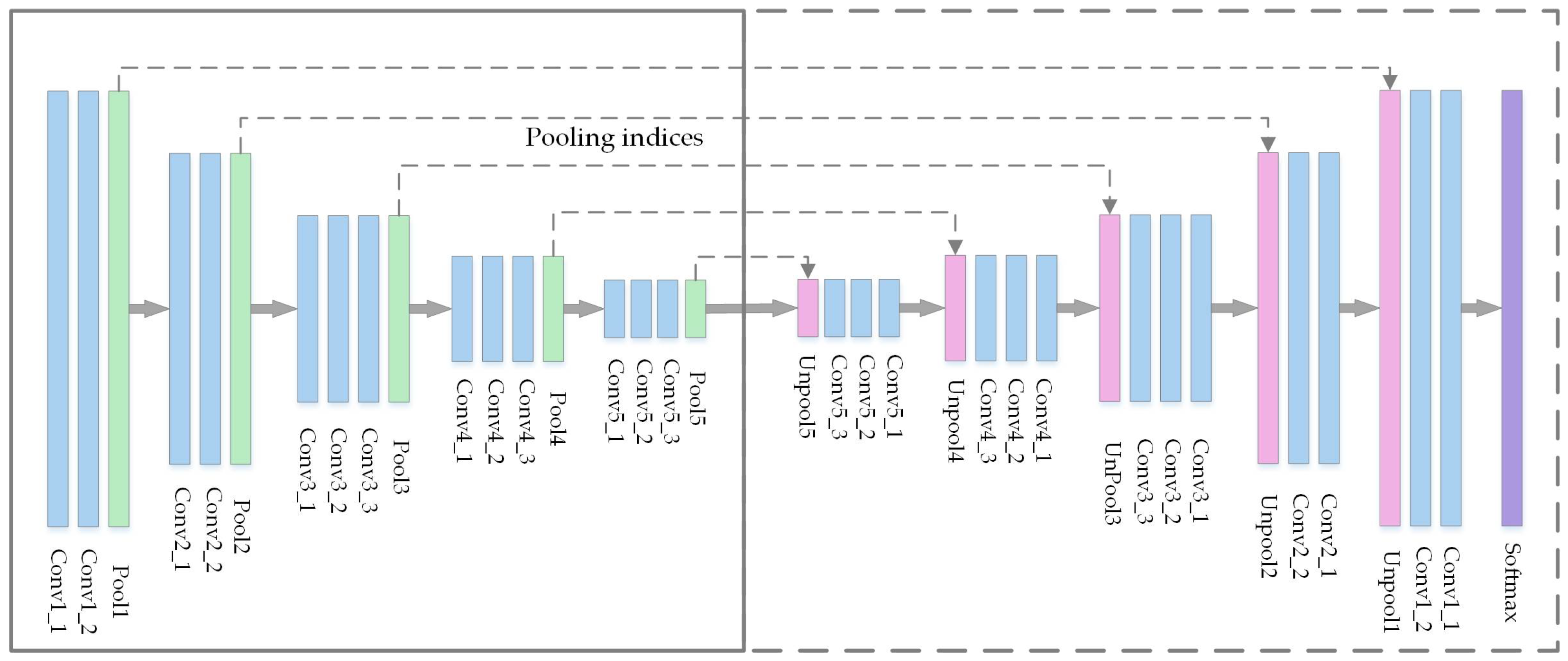
20] presented a novel CNN architecture named SegNet, which shares a similar architecture as DeconvNet but with much smaller parameterization, and is easier to be trained end-to-end.
In recent years, CNNs were gradually applied into semantic segmentation for remote sensing images. In the patch-based methods category, Paisitkriangkrai et al. [
21] suggested to integrate CNN features with handcraft features, and utilized CRFs to further improve the classification performance. Nogueira et al. [
22] compared several existing powerful CNNs with three train strategies, which are training from scratch, fine-tuning, and using CNNs as feature extractor. Experimental results on three remote sensing datasets indicated that the fine-tuning is the best strategy. In [
1], a FCN architecture without downsampling was proposed to mitigate feature detail loss. The architecture had a pre-trained network for color-infrared (CIR) images and a network trained from scratch for digital surface model data. The features of these two networks were then combined by concatenation. Although this architecture achieved state-of-the-art semantic labeling accuracy for high-resolution aerial imagery, it soon was outperformed by downsample- then-upsample architectures for its limited receptive field. Moreover, its decision-level fusion strategy is bound to train two separate neural networks for CIR images and LiDAR data respectively, which means the number of trainable parameters is doubled. Audebert et al. [
23] transferred a powerful semantic segmentation architecture from generic images (SegNet [
20]) to remote sensing images. They compared both decision-level and feature-level fusion methods, and proved their proposed dual stream SegNet to fuse multi-sensor data by residual correction in the feature level performed slightly better. Our FSN also applied feature-level fusion, but ours differs from their method in two ways. First, we processed LiDAR data by a lighter weighed branch, which guarantees the reduction of the computational overhead. Moreover, since CIR data contain more information than LiDAR data, we concatenate features from main encoder and lightweight branch in different depth while they concatenate the features of heterogeneous data in the same depth. In [
24], Liu et al. fused a FCN trained on CIR images and a logistic regression trained on light detection and ranging (LiDAR) data in the decision level by a higher-order CRF framework, which outperformed the original counterparts. In [
25], Volpi et al. applied learnable transpose convolutional layers in the decoder stage to decrease the spatial information loss, but the segmentation accuracy was still limited. In [
26], Maggiori et al. analyzed some dense semantic labeling CNNs of high-resolution remote sensing imagery deeply, and derived a CNN framework with a multi-layer perceptron to learn to combine features at different resolutions. In [
27], an hourglass-shape network was designed followed by a downsample-then-upsample paradigm, which introduced inception module to take advantage of multi-scale receptive fields, together with residual units to feed information from encoder to decoder directly. However, the methods in [
25,
26,
27] did not pay much attention to multi-sensor data fusion problem. They fused CIR images and the LiDAR data in the first layer, which usually cannot exploit the features of each data and cannot obtain satisfying results.
In summary, it can be concluded that pixel-based methods achieve better performance than patch-based methods, and training from scratch is often outperformed by fine-tuning a pre-trained network. Although deep learning has achieved a solid success in semantic segmentation for remote sensing images, the well-known trade-off between recognition and localization [
18,
19] remains a challenging endeavor. Down-sampling operations give the network wider vision to produce more accurate recognition, but the small sized feature maps may lead to inaccurate location. Down-sampling operation can offer the network wider receptive field to obtain more accurate recognition, but the smaller feature maps may result in inaccurate localization. Besides, the existing upscale methods such as transposed convolutional layer and unpooling layer tend to bring artificial values in the low resolution feature maps and then upscale these low resolution feature maps. This can cause an information loss, and therefore decrease the segmentation accuracy. Moreover, multi-sensor data often are fused at the decision-level or are stacked together as input. The former approach suffers from the large number of parameters, and the latter makes the network unable to be initialized by pre-trained weights which is proved to be superior to random initialization [
22,
23,
24].
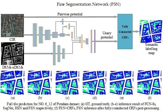
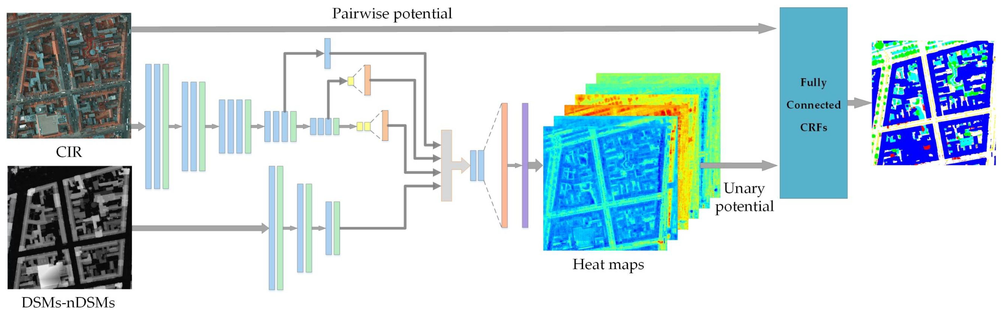
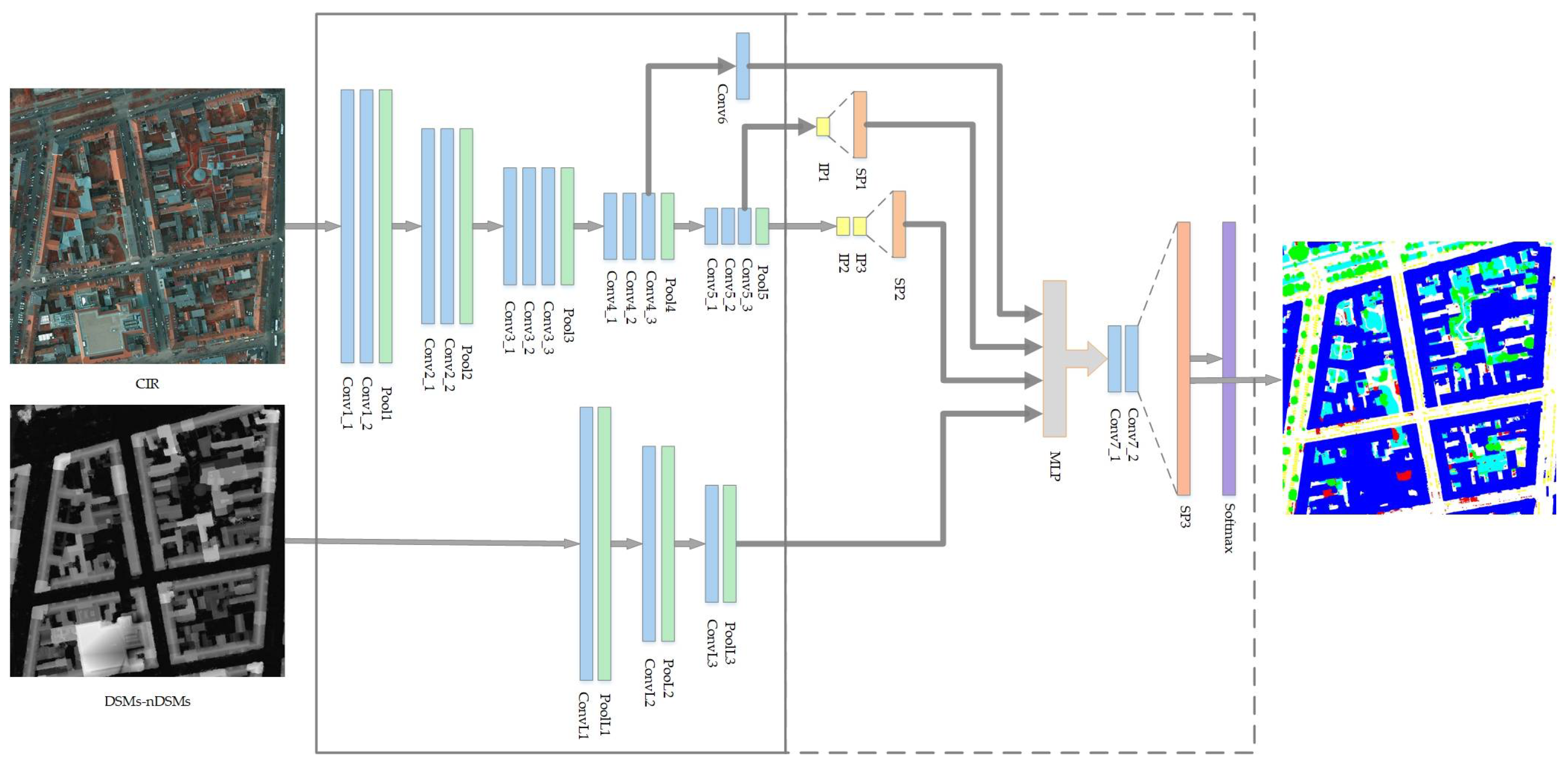
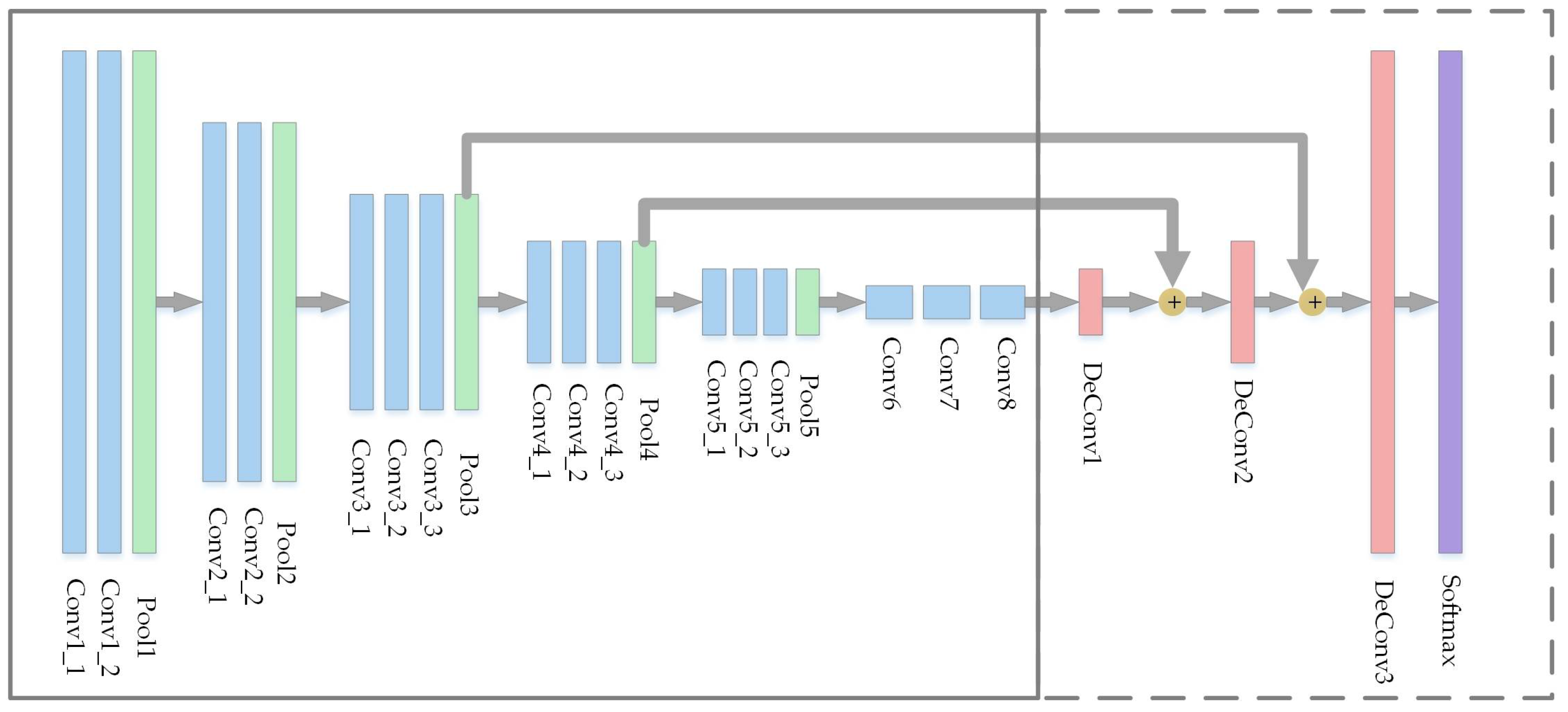
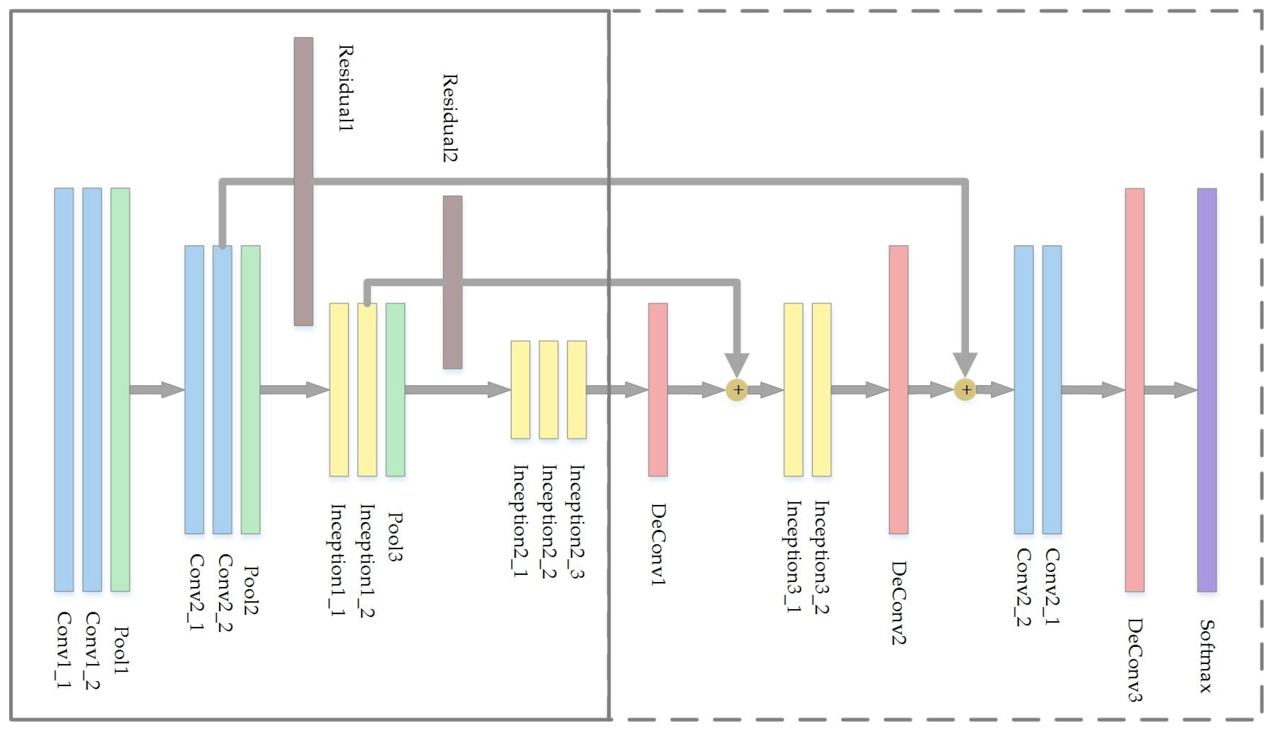
In this paper, a new CNN-based architecture named fine segmentation network (FSN) is proposed for semantic segmentation of high resolution aerial imagery. The FSN belongs to pixel-based methods category and follows the encoder–decoder paradigm as FCN; moreover, it fuses the multi-sensor data in feature-level by multi-layer perceptron (MLP). The main contributions of the proposed network can be summarized as follows:
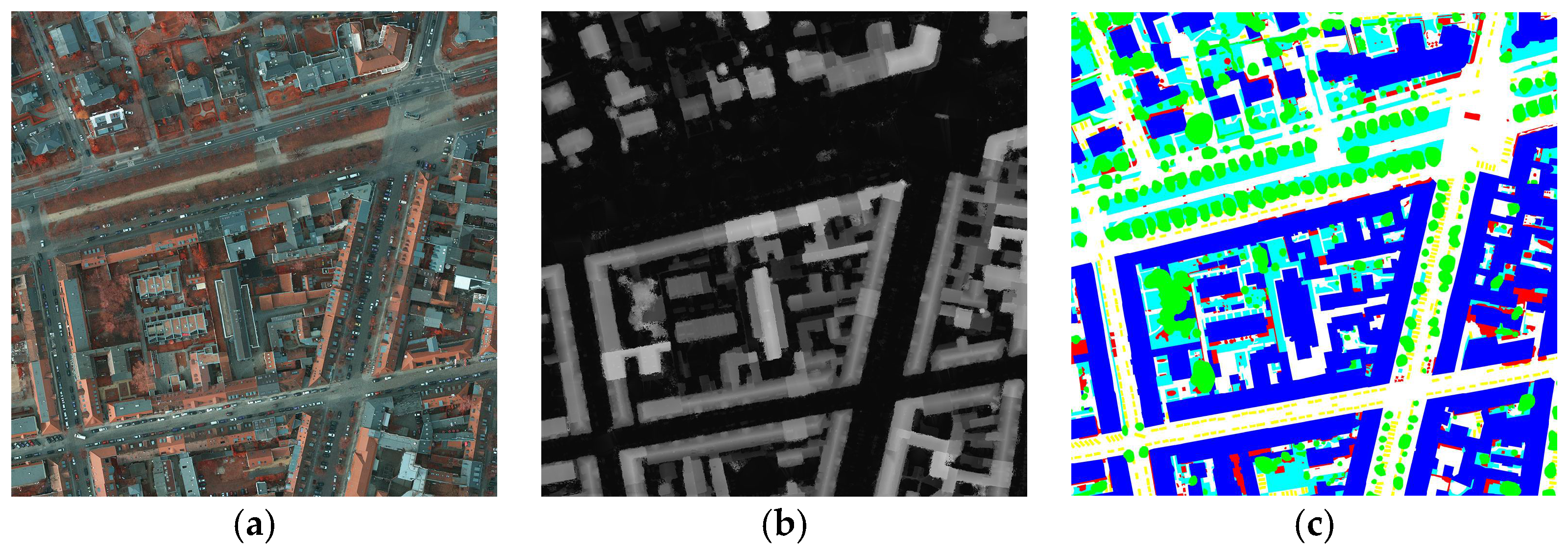
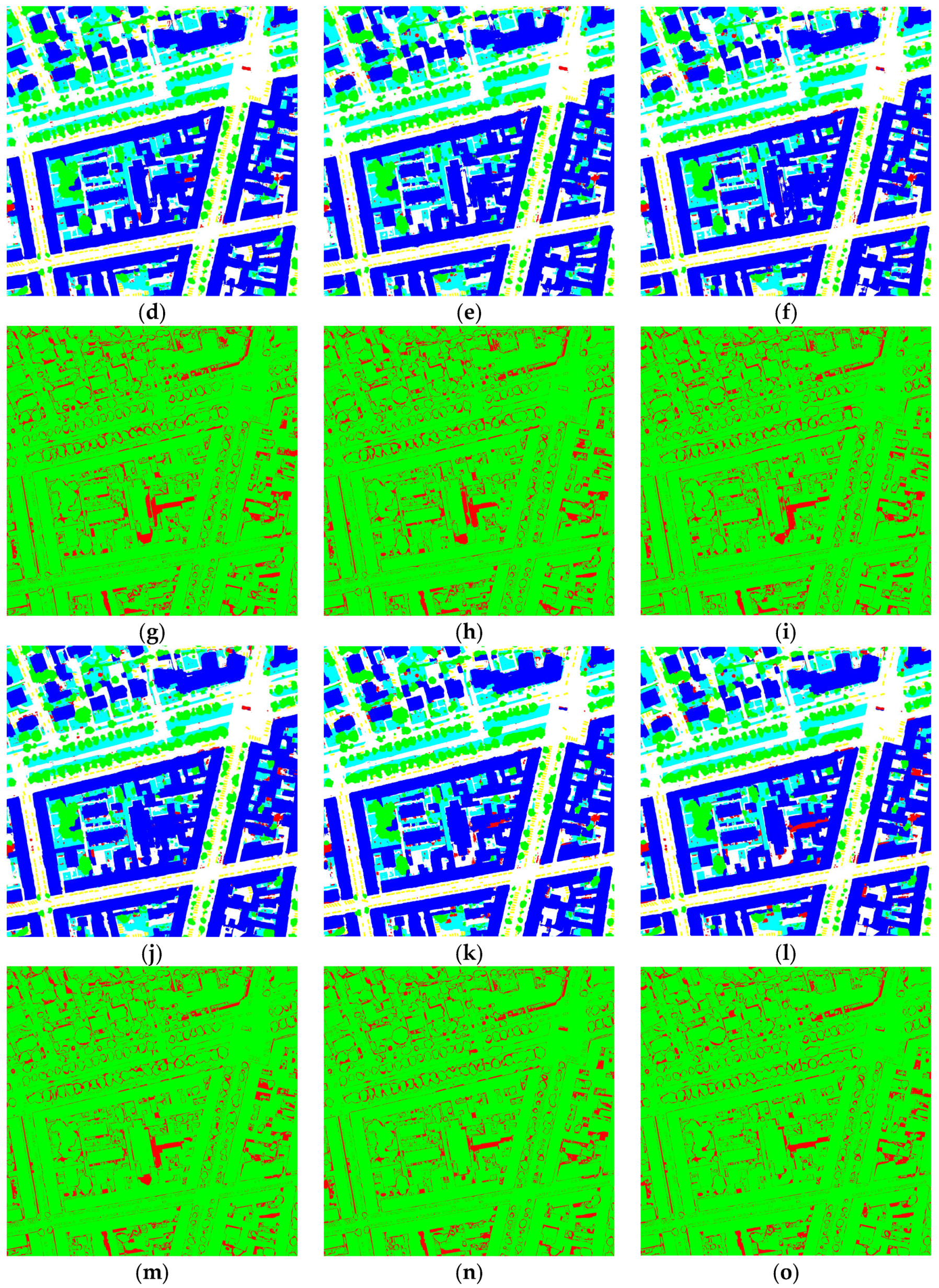
The proposed FSN is evaluated on the International Society for Photogrammetry and Remote Sensing (ISPRS) Potsdam and Vaihingen 2D Semantic Labeling datasets. Experimental results demonstrate that it can bring considerable improvement to other related networks.
The reminder of this paper is organized as follows. In
Section 2, a brief introduction for the main component of convolutional neural network is presented. In
Section 3, the proposed FSN is detailed at the beginning, followed by a presentation for the post-processing method.
Section 4 presents data and experiment settings, and experimental results.
Section 5 draws the conclusions.
2. Convolutional Neural Network
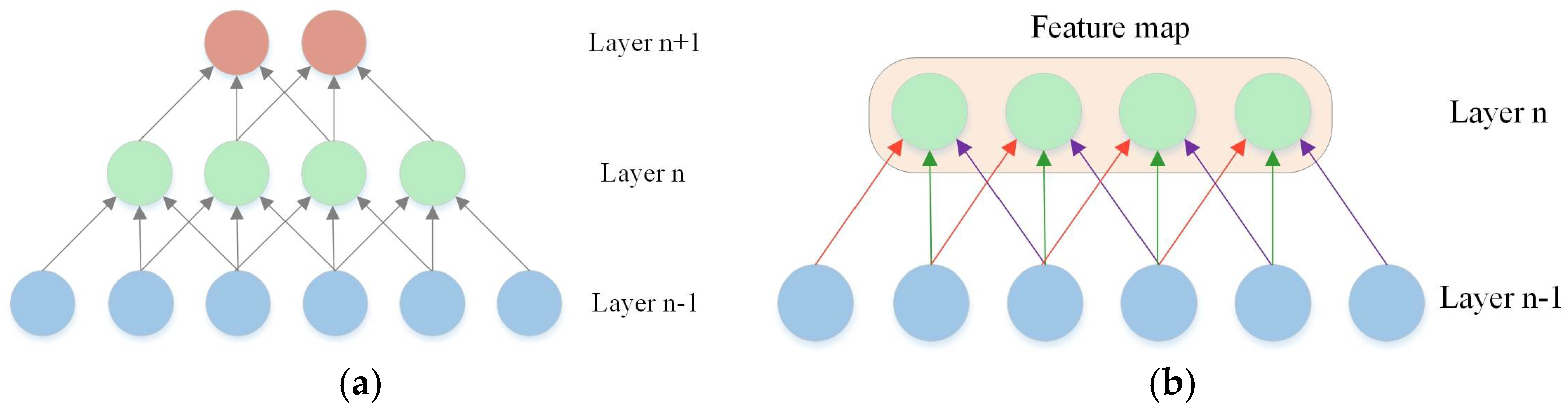
Convolutional neural network [
30] is a special version of deep neural network which is characterized by sparse connectivity and parameter sharing. Sparse connectivity means the neurons of CNNs are not fully connected, as shown in
Figure 1a; indeed, each two layers are partially connected to make better use of local spatial characteristics. Parameter sharing means neurons in one feature map share a same parameters matrix. As shown in
Figure 1b, layer
n has four neurons belonging to one feature mapping, and connection lines of the same color identify the same weights. These two characteristics reduce the complexity of the network structure and the total amount of parameters.
CNNs can also be considered as a complex non-linear function to turn the inputs into target variables. In this section, we briefly present an introduction of CNNs’ main composition elements. The basic type of CNN layers in semantic segmentation include: convolutional layer, non-linear activation layer, spatial pooling layer, transposed convolutional layer, and unpooling layer.
2.1. Convolutional Layer
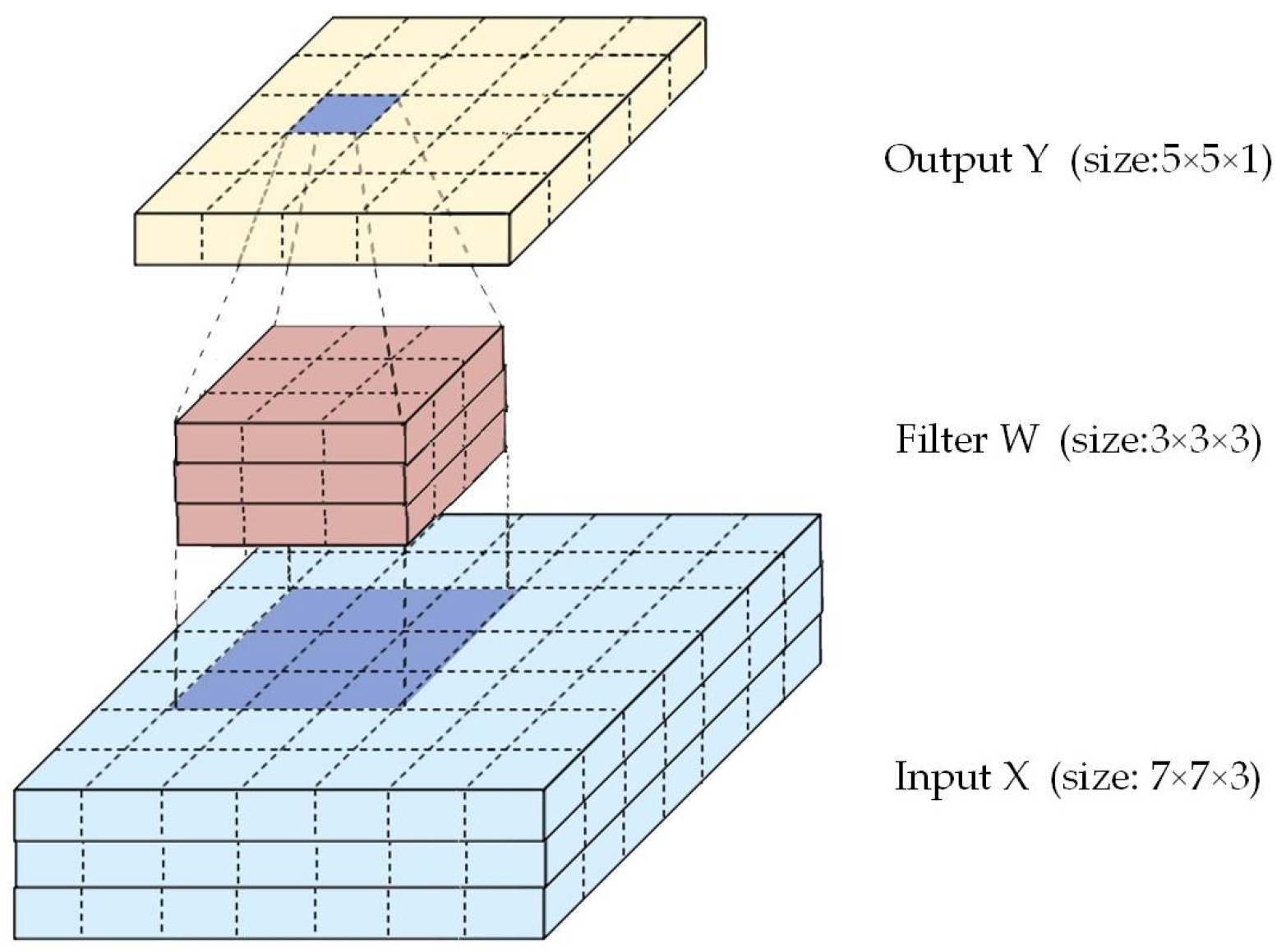
The convolutional layers are the main component of CNNs. A convolutional layer can be considered as a set of neurons or filters. Each filter has a series of learnable parameters which are arranged as a convolution kernel with size
P ×
Q ×
D, where
P,
Q and
D represent length, width and depth of convolution kernel, respectively. The conversion of input image with size
Ni ×
Li ×
D to output of convoltional layer with size
No ×
Lo ×
D′ is performed by convolutional layer (a set of
D′ filters). When the filter is centered on the spatial position (
i,
j) of the input, and the response for the
d′-th filter can be written as:
where
yijd′ is the response for
d′-th filter,
xpqd is the window surrounding spatial position (
i,
j) of the input,
Wpqd is the learnable weights of convolution kernel, and
b is a learnable bias. The spatial dimensions of the output can be calculated as:
where
Z is the number of rows and columns padded on the borders of input, and
S is the stride of convolution kernel sliding.
Figure 2 reports an example where input image is of size 7 × 7 × 3, and the size of convolution kernel is 3 × 3 × 3. Moreover, the convolution is performed with stride 1 without padding, and only one filter is employed. Then, the size of output is 5 × 5 × 1.
2.2. Nonlinear Activation Layer
Generally, neural network for image process aims to perform convolutions to images, but this operation is obviously linear. Thus, nonlinear activation layer is introduced into CNNs to increase the network’s ability to express any complex non-linear mapping. The most common nonlinear activation applied in CNNs is the Rectified Linear Unit (ReLU) function [
31], formulated as:
Other common activation functions include Sigmoid function, Tanh function, and leaky ReLU function [
32].
2.3. Spatial Pooling Layer
The role of spatial pooling layer is to reduce the dimensionality of the representation and create an invariance of small shifts and distortions by pooling over small windows into single values [
33]. Spatial pooling operation often utilizes small windows (e.g., 2 × 2 or 3 × 3), to slide over the feature maps, and convert the information within the window into a single value. The existing pooling methods include max pooling, mean pooling, and sum pooling functions. In this paper, the max pooling function is taken into consideration due to its stability and wide application in the literature. Given the size of window as
P ×
P,
Pij denotes the window centered on the spatial location of (
i,
j). Then, max pooling function returns the maximum value of the window area as:
2.4. Transposed Convolutional Layer
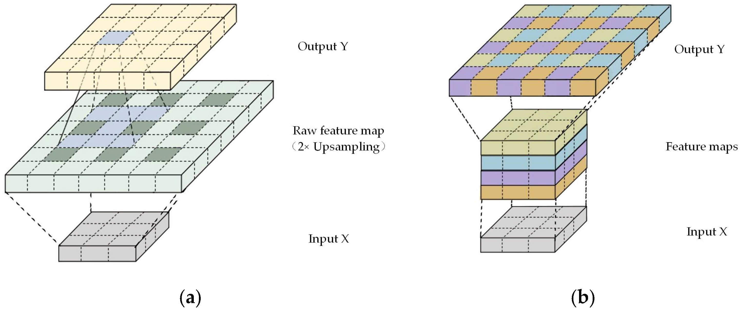
Transposed convolution is also called deconvolution [
34]. In semantic segmentation area, transpose convolution is a popular approach to recover the lost feature details caused by pooling operations or other downsampling operations. The low resolution input is first up-scaled by using bilinear interpolation or adding zeros, and then the convolutional operations are employed on the raw up-scaled results to fit in sensible values.
2.5. Unpooling Layer
Unpooling, is the reverse operation of pooling. Pooling is an irreversible operation; therefore, the position of the max value is recorded in the pooling stage (take max pooling as example). In the unpooling stage, only the value of the recorded position is activated, whilst the value of other position is set to 0.


