A Random Forest-Based Approach to Map Soil Erosion Risk Distribution in Hickory Plantations in Western Zhejiang Province, China

 ,
,
Abstract

1. Introduction
2. Materials and Methods
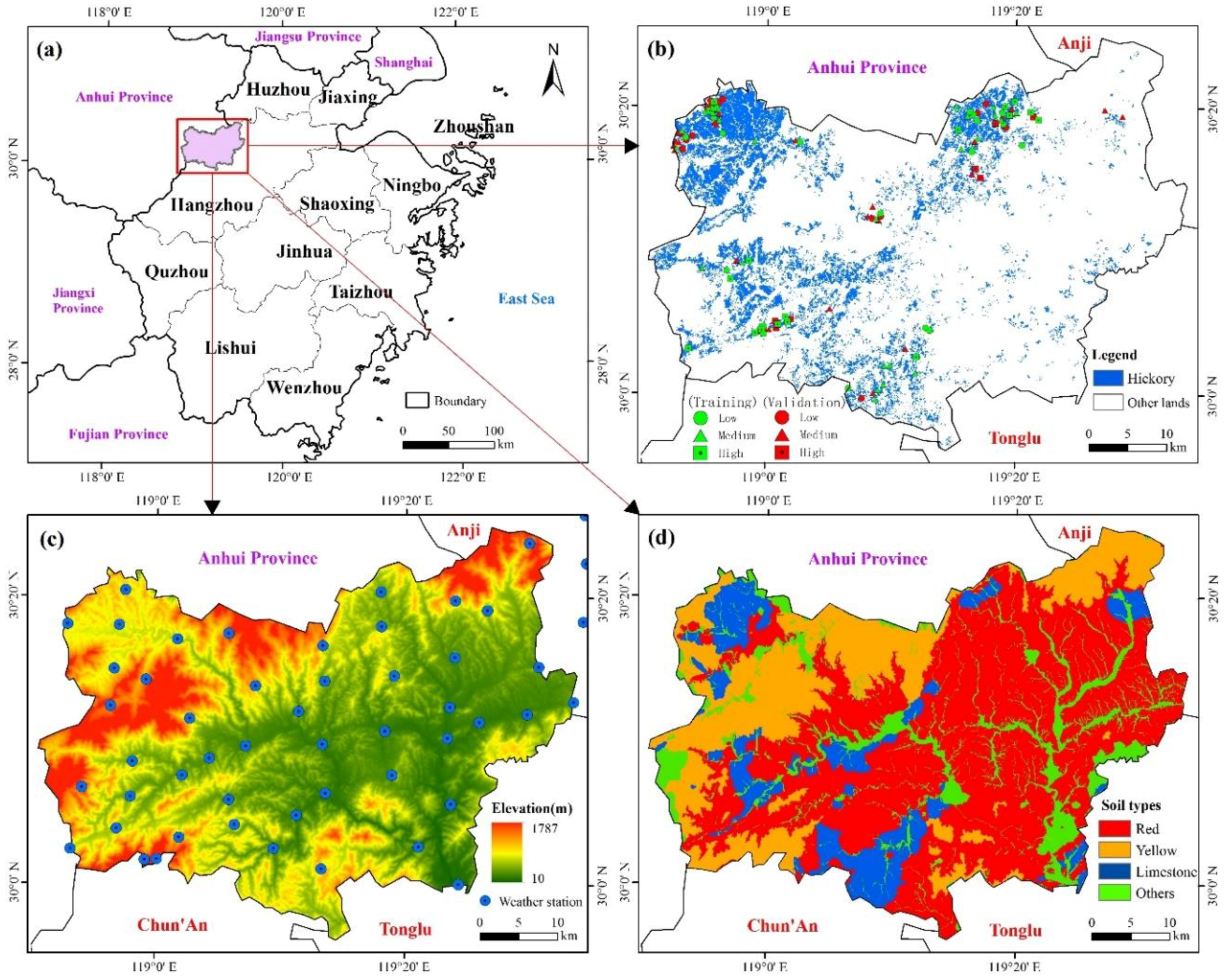
2.1. Study Area
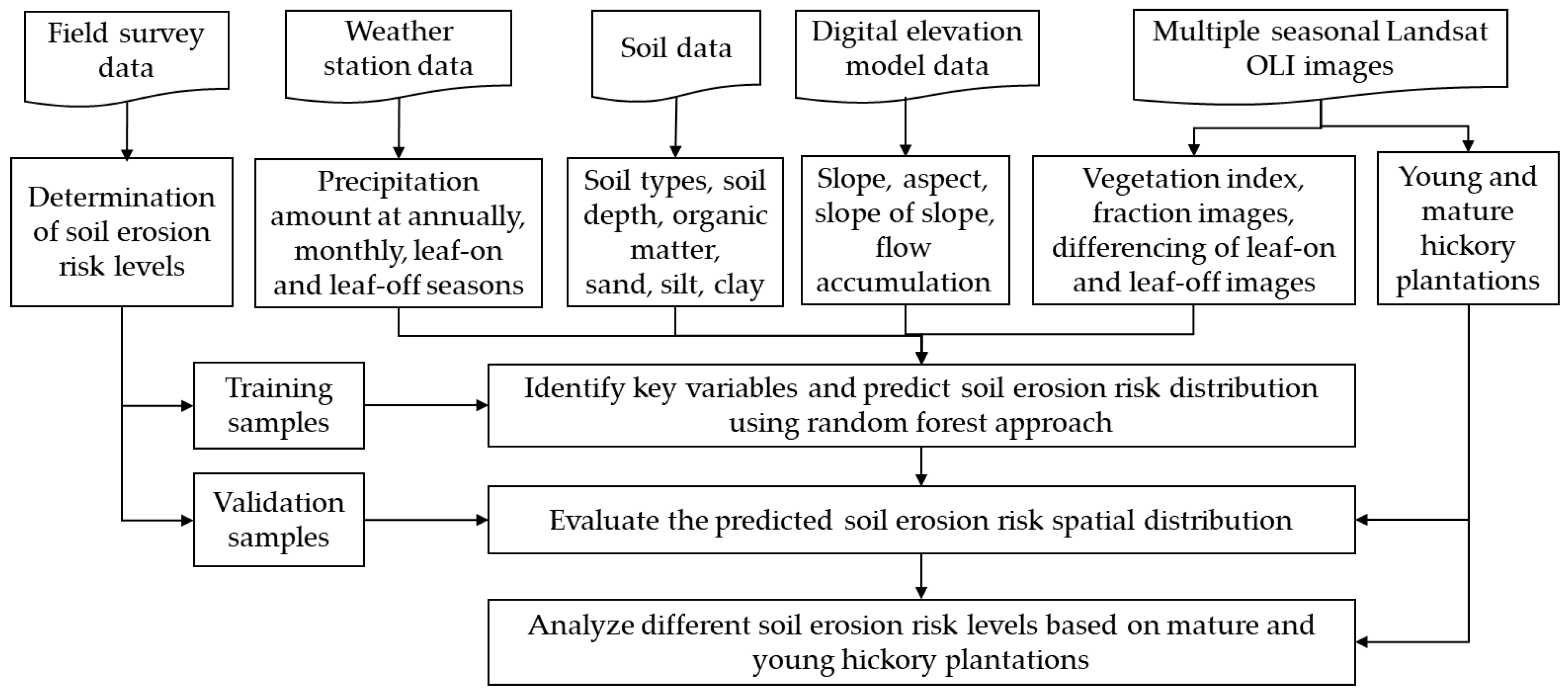
2.2. Data Collection and Processing
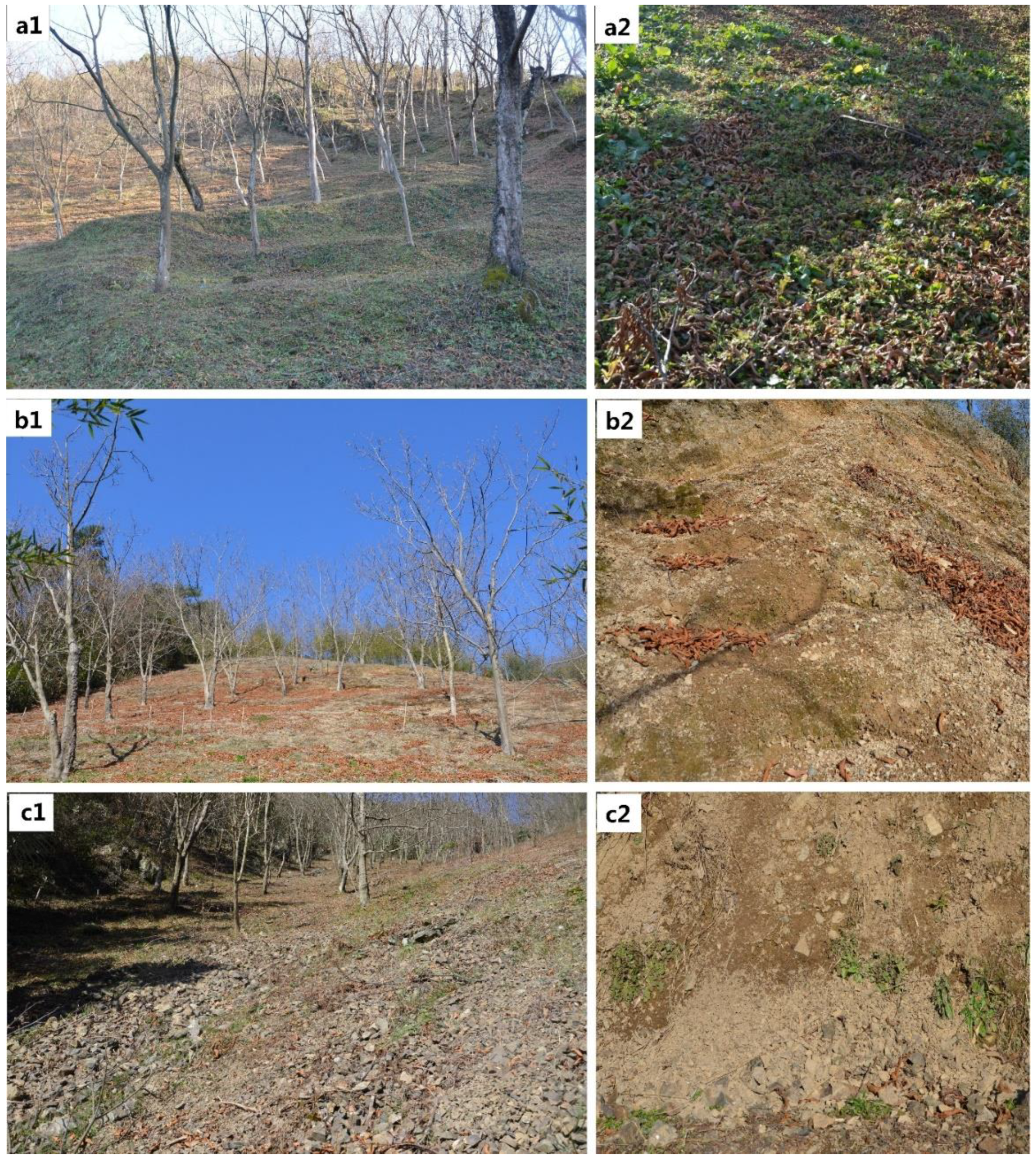
2.2.1. Field Data Collection and Determination of Soil Erosion Risk Levels
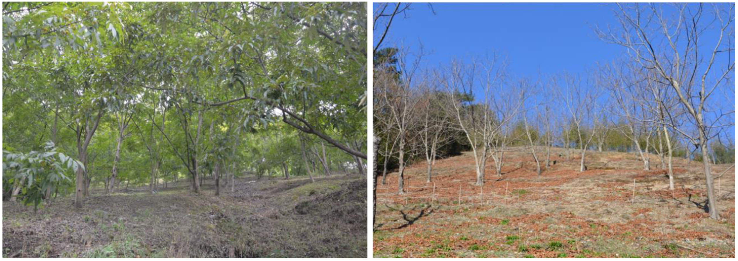
2.2.2. Remote-Sensing Data Processing and Mapping of Hickory Plantations
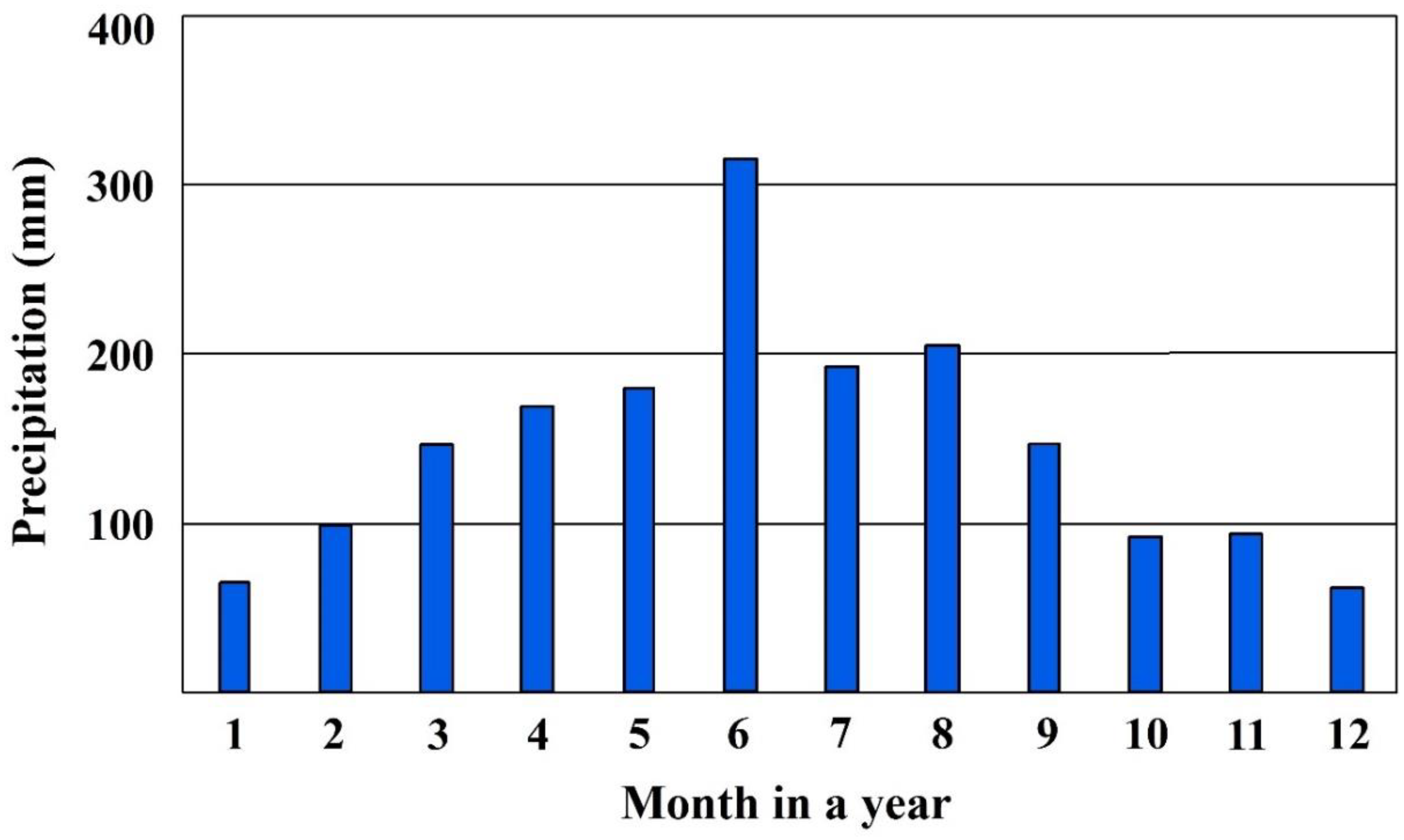
2.2.3. Collection of Precipitation Data and Development of Its Spatial Distribution
2.2.4. Collection and Processing of Soil Data
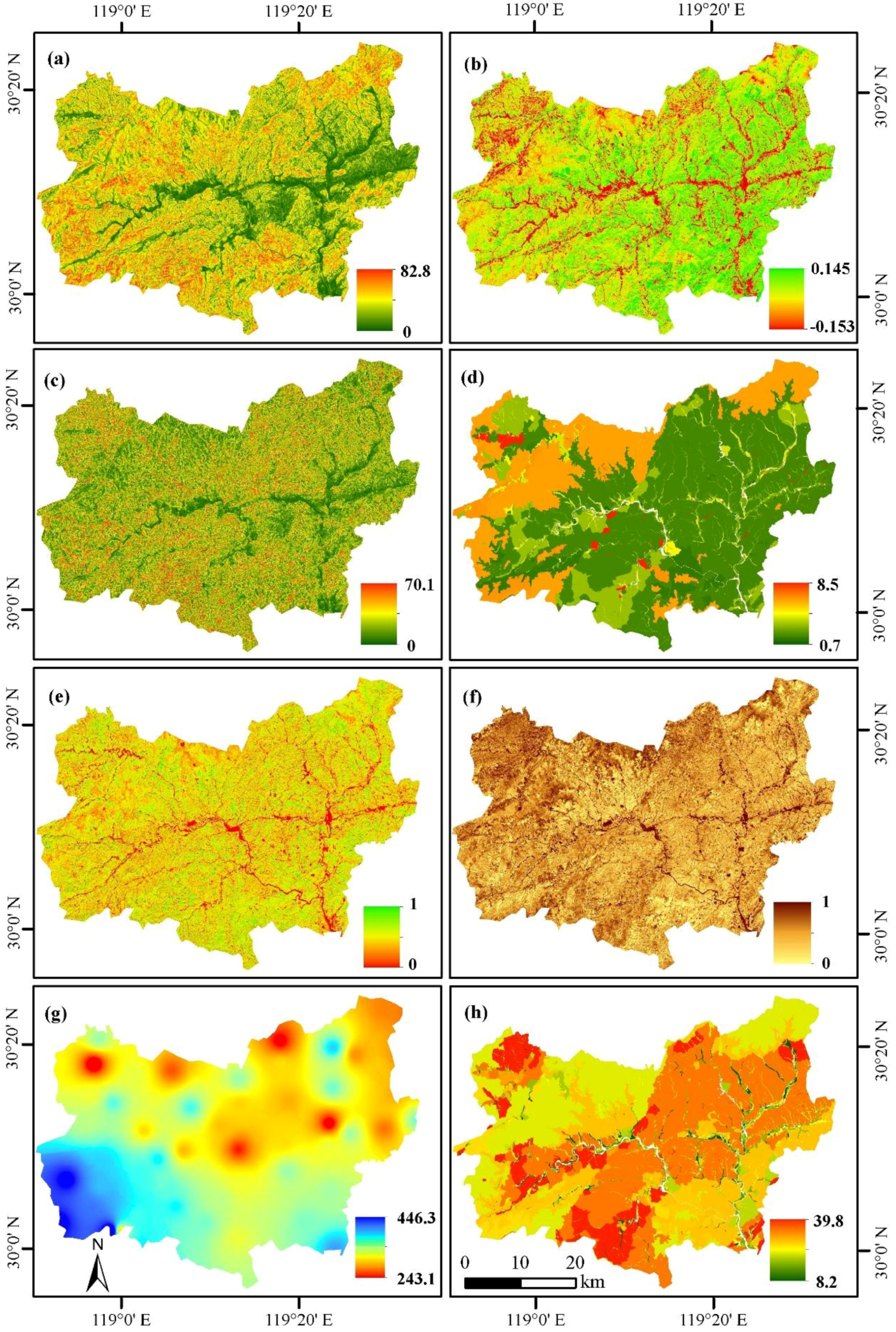
2.2.5. Extraction of Topographic Factors
2.3. Determination of Key Variables for Mapping Soil Erosion Risk Distribution and Evaluation of Mapping Results
3. Results
3.1. Analysis of Selected Key Variables for Mapping Soil Erosion Risk Distribution
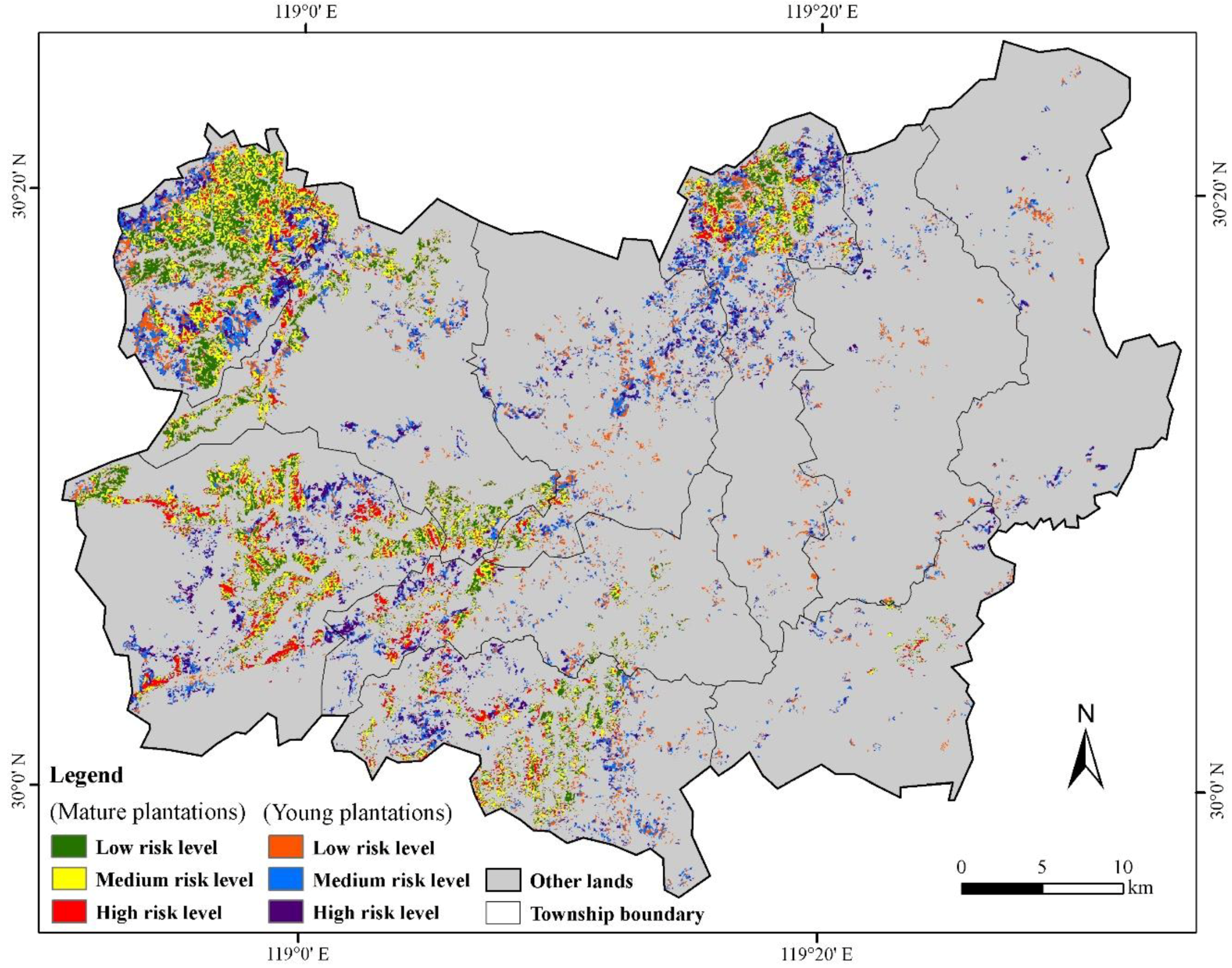
3.2. Analysis of Soil Erosion Risk Mapping Results
4. Discussion
4.1. The Roles of Remote-Sensing Data in Soil Erosion Risk Mapping
4.2. The Roles of GIS in Soil Erosion Risk Mapping
4.3. The Approach to Identify Key Variables for Mapping Soil Erosion Risk Distribution
5. Conclusions
Supplementary Materials
Author Contributions
Funding
Acknowledgments
Conflicts of Interest
References
- Gusarov, A.V.; Golosov, V.N.; Sharifullin, A.G. Contribution of climate and land cover changes to reduction in soil erosion rates within small cultivated catchments in the eastern part of the Russian plain during the last 60 years. Environ. Res. 2018, 167, 21–33. [Google Scholar] [CrossRef] [PubMed]
- Kouli, M.; Soupios, P.; Vallianatos, F. Soil erosion prediction using the revised universal soil loss equation (RUSLE) in a GIS framework, Chania, Northwestern Crete, Greece. Environ. Geol. 2008, 57, 483–497. [Google Scholar] [CrossRef]
- Lu, W.; Lu, D.; Wang, G.; Wu, J.; Huang, J.; Li, G. Examining soil organic carbon distribution and dynamic change in a hickory plantation region with Landsat and ancillary data. Catena 2018, 165, 576–589. [Google Scholar] [CrossRef]
- Wang, Y.; Lu, D. Mapping Torreya grandis spatial distribution using high spatial resolution satellite imagery with the expert rules-based approach. Remote Sens. 2017, 9, 564. [Google Scholar] [CrossRef]
- Huang, J.; Lu, D.; Li, J.; Wu, J.; Chen, S.; Zhao, W.; Ge, H.; Huang, X.; Yan, X. Integration of remote sensing and GIS for evaluating soil erosion risk in northwestern Zhejiang, China. Photogramm. Eng. Remote Sens. 2012, 78, 935–946. [Google Scholar] [CrossRef]
- Zhang, R.; Peng, F.; Li, Y. Pecan production in China. Sci. Hortic. 2015, 197, 719–727. [Google Scholar] [CrossRef]
- Ding, L.; Zhong, Y. Lin’an hickory. China Qual. Stand. Rev. 2014, 17, 66–68. [Google Scholar]
- Renard, K.G.; Foster, G.R.; Weesies, G.A.; McCool, D.K.; Yoder, D.C. Predicting Soil Erosion by Water: A Guide to Conservation Planning With the Revised Universal Soil Loss Equation (Rusle); Agricultural Handbook, Number 703; US Department of Agriculture: Washington, DC, USA, 1997; p. 404.
- Lu, D.; Batistella, M.; Mausel, P.; Moran, E. Mapping and monitoring land degradation risks in the western Brazilian Amazon using multitemporal Landsat TM/ETM+ images. Land Degrad. Dev. 2007, 18, 41–54. [Google Scholar] [CrossRef]
- Wang, G.; Wente, S.; Gertner, G.Z.; Anderson, A. Improvement in mapping vegetation cover factor for the universal soil loss equation by geostatistical methods with Landsat Thametic Mapper images. Int. J. Remote Sens. 2002, 23, 3649–3667. [Google Scholar] [CrossRef]
- Wang, G.; Gertner, G.; Anderson, A.B.; Howard, H.; Gebhart, D.; Althoff, D.; Davis, T.; Woodford, P. Spatial variability and temporal dynamics analysis of soil erosion due to military land use activities: Uncertainty and implications for land management. Land Degrad. Dev. 2007, 18, 519–542. [Google Scholar] [CrossRef]
- Wang, G.; Gertner, G.; Anderson, A.B. Efficiencies of remotely sensed data and sensitivity of grid spacing in sampling and mapping a soil erosion relevant cover factor by cokriging. Int. J. Remote Sens. 2009, 30, 4457–4477. [Google Scholar] [CrossRef]
- Albaradeyia, I.; Hani, A.; Shahrour, I. WEPP and ANN models for simulating soil loss and runoff in a semi-arid mediterranean region. Environ. Monit. Assess. 2011, 180, 537–556. [Google Scholar] [CrossRef] [PubMed]
- Sinha, N.; Deb, D.; Pathak, K. Development of a mining landscape and assessment of its soil erosion potential using GIS. Eng. Geol. 2017, 216, 1–12. [Google Scholar] [CrossRef]
- Wischmeier, W.H.; Smith, D.D. Predicting Rainfall Erosion Losses: A Guide to Conservation Planning; Agricultural Handbook, Number 537; US Department of Agriculture: Washington, DC, USA, 1978; p. 163.
- Williams, J.R.; Berndt, H.D. Sediment yield prediction based on watershed hydrology. Trans. Am. Soc. Agric. Eng. 1977, 20, 1100–1104. [Google Scholar] [CrossRef]
- Nearing, M.A.; Foster, G.R.; Lane, L.J.; Finkner, S.C. A process-based soil erosion model for USDA-water erosion prediction project technology. Trans. ASAE 1989, 32, 1587–1593. [Google Scholar] [CrossRef]
- Arnold, J.G.; Srinivasan, R.; Muttiah, R.S.; Williams, J.R. Large area hydrologic modeling and assessment: Part I: Model development. J. Am. Water Resour. Assoc. 1998, 34, 73–89. [Google Scholar] [CrossRef]
- Young, R.A.; Onstad, C.A.; Bosch, D.D.; Anderson, W.P. AGNPS: A nonpoint-source pollution model for evaluating agricultural watersheds. J. Soil Water Conserv. 1989, 44, 168–173. [Google Scholar]
- Kliment, Z.; Kadle, J.; Langhammer, J. Evaluation of suspended load changes using ANN AGNPS and SWAT semi-empirical erosion models. Catena 2008, 97, 286–299. [Google Scholar] [CrossRef]
- Walling, E.; He, Q.; Whelan, P.A. Using 137Cs measurements to validate the application of the AGNPS and ANSWERS erosion and sediment yield models in two small Devon catchments. Soil Tillage Res. 2003, 69, 27–43. [Google Scholar] [CrossRef]
- Recolainen, S.; Posch, M. Adapting the CREAMS model for Finnish conditions. Nord. Hydrol. 1993, 24, 309–322. [Google Scholar] [CrossRef]
- Morgan, R.P.C.; Quinton, J.N.; Smith, R.E.; Govers, G.; Poesen, J.W.A.; Auerswald, K.; Chisci, G.; Torri, D.; Styczen, M.E. The European soil erosion model (EUROSEM): A dynamic approach for predicting sediment transport from fields and small catchments. Earth Surf. Process. Landf. 1998, 23, 527–544. [Google Scholar] [CrossRef]
- Kirkby, M.J.; Irvine, B.J.; Jones, R.J.A.; Govers, G. The PESERA coarse scale erosion model for Europe. I.—Model rationale and implementation. Eur. J. Soil Sci. 2008, 59, 1293–1306. [Google Scholar] [CrossRef]
- Udayakumara, E.P.N.; Shrestha, R.P.; Samarakoon, L.; Schmidt-Vogt, D. People’s perception and socioeconomic determinants of soil erosion: A case study of Samanalawewa watershed, Sri Lanka. Int. J. Sediment Res. 2010, 25, 323–339. [Google Scholar] [CrossRef]
- Shi, Z.; Ai, L.; Fang, N.; Zhu, H. Modeling the impacts of integrated small watershed management on soil erosion and sediment delivery: A case study in the Three Gorges Area, China. J. Hydrol. 2012, 438, 156–167. [Google Scholar] [CrossRef]
- Routschek, A.; Schmidt, J.; Kreienkamp, F. Impact of climate change on soil erosion: A high-resolution projection on catchment scale until 2100 in Saxony/Germany. Catena 2014, 121, 99–109. [Google Scholar] [CrossRef]
- Ji, U.; Velleux, M.; Julien, P.Y.; Hwang, M. Risk assessment of watershed erosion at Naesung Stream, South Korea. J. Environ. Manag. 2014, 136, 16–26. [Google Scholar] [CrossRef] [PubMed]
- Fu, G.; Chen, S.; McCool, D.K. Modeling the impacts of no-till practice on soil erosion and sediment yield with RUSLE, SEDD, and ArcView GIS. Soil Tillage Res. 2006, 85, 38–49. [Google Scholar] [CrossRef]
- Wu, Q.; Wang, M. A framework for risk assessment on soil erosion by water using an integrated and systematic approach. J. Hydrol. 2007, 337, 11–21. [Google Scholar] [CrossRef]
- Zhang, X.; Wu, B.; Ling, F.; Zeng, Y.; Yan, N.; Yuan, C. Identification of priority areas for controlling soil erosion. Catena 2010, 83, 76–85. [Google Scholar] [CrossRef]
- Vijith, H.; Suma, M.; Rekha, V.B.; Shiju, C.; Rejith, P.J. An assessment of soil erosion probability and erosion rate in a tropical mountainous watershed using remote sensing and GIS. Arab. J. Geosci. 2011, 5, 797–804. [Google Scholar] [CrossRef]
- Angima, S.D.; Stott, D.E.; Oneill, M.K.; Ong, C.K.; Weesies, G.A. Soil erosion prediction using RUSLE for central Kenyan highland conditions. Agric. Ecosyst. Environ. 2003, 97, 295–308. [Google Scholar] [CrossRef]
- Lu, D.; Li, G.; Valladares, G.S.; Batistella, M. Mapping soil erosion risk in Rondônia, Brazilian Amazonia: Using RUSLE, remote sensing and GIS. Land Degrad. Dev. 2004, 15, 499–512. [Google Scholar] [CrossRef]
- Park, S.; Oh, C.; Jeon, S.; Jung, H.; Choi, C. Soil erosion risk in Korean watersheds, assessed using the revised universal soil loss equation. J. Hydrol. 2011, 399, 263–273. [Google Scholar] [CrossRef]
- Thomas, J.; Joseph, S.; Thrivikramji, K.P. Assessment of soil erosion in a tropical mountain river basin of the southern Western Ghats, India using RUSLE and GIS. Geosci. Front. 2018, 9, 893–906. [Google Scholar] [CrossRef]
- Conforti, M.; Buttafuoco, G. Assessing space-time variations of denudation processes and related soil loss from 1955 to 2016 in southern Italy (Calabria region). Environ. Earth Sci. 2017, 76, 457. [Google Scholar] [CrossRef]
- Ferreira, V.; Panagopoulos, T.; Cakula, A.; Andrade, R.; Arvela, A. Predicting soil erosion after land use changes for irrigating agriculture in a large reservoir of southern Portugal. Agric. Agric. Sci. Procedia 2015, 4, 40–49. [Google Scholar] [CrossRef]
- Brhane, G.; Mekonen, K. Estimating soil loss using Universal Soil Loss Equation (USLE) for soil conservation planning at Medego watershed, Northern Ethiopia. J. Am. Sci. 2009, 5, 58–69. [Google Scholar]
- Pei, T.; Qin, C.; Zhu, A.; Yang, L.; Luo, M.; Li, B.; Zhou, C. Mapping soil organic matter using the topographic wetness index: A comparative study based on different flow-direction algorithms and kriging methods. Ecol. Indic. 2010, 10, 610–619. [Google Scholar] [CrossRef]
- Prasannakumar, V.; Vijith, H.; Abinod, S.; Geetha, N. Estimation of soil erosion risk within a small mountainous sub-watershed in Kerala, India, using revised universal soil loss equation (RUSLE) and geo-information technology. Geosci. Front. 2012, 3, 209–215. [Google Scholar] [CrossRef]
- Jiang, Z.; Su, S.; Jing, C.; Lin, S.; Fei, X.; Wu, J. Spatiotemporal dynamics of soil erosion risk for Anji county, China. Stoch. Environ. Res. Risk Assess. 2012, 26, 751–763. [Google Scholar] [CrossRef]
- Breiman, L. Random forests. Mach. Learn. 2001, 45, 5–32. [Google Scholar] [CrossRef]
- Lu, D.; Chen, Q.; Wang, G.; Liu, L.; Li, G.; Moran, E. A survey of remote sensing-based aboveground biomass estimation methods in forest ecosystems. Int. J. Digit. Earth 2016, 9, 63–105. [Google Scholar] [CrossRef]
- Gao, Y.; Lu, D.; Li, G.; Wang, G.; Chen, Q.; Liu, L.; Li, D. Comparative analysis of modeling algorithms for forest aboveground biomass estimation in a subtropical region. Remote Sens. 2018, 10, 627. [Google Scholar] [CrossRef]
- Clark, M.L.; Roberts, D.A. Species-level differences in hyperspectral metrics among tropical rainforest trees as determined by a tree-based classifier. Remote Sens. 2012, 4, 1820–1855. [Google Scholar] [CrossRef]
- Rodriguez-Galiano, V.F.; Ghimire, B.; Rogan, J.; Chica-Olmo, M.; Rigol-Sanchez, J.P. An assessment of the effectiveness of a random forest classifier for land-cover classification. ISPRS J. Photogramm. Remote Sens. 2012, 67, 93–104. [Google Scholar] [CrossRef]
- Liaw, A.; Wiener, M. Classification and regression by random forest. R News 2002, 2, 18–22. [Google Scholar]
- Mutanga, O.; Adam, E.; Cho, M.A. High density biomass estimation for wetland vegetation using Worldview-2 imagery and random forest regression algorithm. Int. J. Appl. Earth Obs. Geoinf. 2012, 18, 399–406. [Google Scholar] [CrossRef]
- Vincenzi, S.; Zucchetta, M.; Franzoi, P.; Pellizzato, M.; Pranovi, F.; De Leo, G.A.; Torricelli, P. Application of a random forest algorithm to predict spatial distribution of the potential yield of Ruditapes Philippinarum in the Venice Lagoon, Italy. Ecol. Model. 2011, 222, 1471–1478. [Google Scholar] [CrossRef]
- Xi, Z.; Lu, D.; Liu, L.; Ge, H. Detection of drought-induced hickory disturbances in western Lin An county, China, using multitemporal Landsat imagery. Remote Sens. 2016, 8, 345. [Google Scholar] [CrossRef]
- Wu, J.; Jing, C.; Zhi, J. Soil Geographic Database of Zhejiang Province and Its Applications; Zhejiang University Press: Hangzhou, China, 2014; pp. 41–47. (In Chinese) [Google Scholar]
- Keys to Soil Taxonomy, 12th ed.; United States Department of Agriculture, Natural Resources Conservation Service: Washington, DC, USA, 2014; pp. 37–40.
- World Reference Base for Soil Resources 2014, International Soil Classification System for Naming Soils and Creating Legends for Soil Maps, Update 2015; World Soil Resources Reports, No. 106; FAO: Rome, Italy, 2015.
- Xu, X.; Zhang, Y.; Li, L.; Yang, S. Markets for forestland use rights: A case study in southern China. Land Use Policy 2013, 30, 560–569. [Google Scholar] [CrossRef]
- Wu, D.; Feng, X.; Wen, Q. The research of evaluation for growth suitability of Carya Cathayensis Sarg. Based on PCA and AHP. Procedia Eng. 2011, 15, 1879–1883. [Google Scholar] [CrossRef]
- Ministry of Water Resources. Standards for Classification and Gradation of Soil Erosion (SL190-2007) (111000/2008-00439). Available online: http://www.mwr.gov.cn/zwgk/zfxxgkml/201301/t20130125_965312.html (accessed on 15 August 2018). (In Chinese)
- Song, C.; Woodcock, C.E.; Seto, K.C.; Lenney, M.P.; Macomber, S.A. Classification and change detection using Landsat tm data: When and how to correct atmospheric effects? Remote Sens. Environ. 2011, 75, 230–244. [Google Scholar] [CrossRef]
- Flaash, U.G. Atmospheric Correction Module: Quac and Flaash User Guide v. 4.7; ITT Visual Information Solutions Inc.: Boulder, CO, USA, 2009. [Google Scholar]
- Reese, H.; Olsson, H. C-correction of optical satellite data over alpine vegetation areas: A comparison of sampling strategies for determining the empirical c-parameter. Remote Sens. Environ. 2011, 115, 1387–1400. [Google Scholar] [CrossRef]
- De Asis, A.M.; Omasa, K. Estimation of vegetation parameter for modeling soil erosion using linear spectral mixture analysis of Landsat ETM data. ISPRS J. Photogramm. Remote Sens. 2007, 62, 309–324. [Google Scholar] [CrossRef]
- Rallo, G.; Minacapilli, M.; Ciraolo, G.; Provenzano, G. Detecting crop water status in mature olive groves using vegetation spectral measurements. Biosyst. Eng. 2014, 128, 52–68. [Google Scholar] [CrossRef]
- Lu, D.; Moran, E.; Batistella, M. Linear mixture model applied to Amazonian vegetation classification. Remote Sens. Environ. 2003, 87, 456–469. [Google Scholar] [CrossRef]
- Lu, D.; Li, G.; Moran, E.; Dutra, L.; Batistella, M. The roles of textural images in improving land-cover classification in the Brazilian Amazon. Int. J. Remote Sens. 2014, 35, 8188–8207. [Google Scholar] [CrossRef]
- Cheng, Z.; Lu, D.; Lu, W.; Li, G.; Huang, J.; Zhi, J.; Li, S. Examining hickory plantation expansion and evaluating suitability for it using multitemporal satellite imagery and ancillary data. Appl. Geogr. 2018. submitted for publication. [Google Scholar]
- Congalton, R.G.; Green, K. Assessing the Accuracy of Remotely Sensed Data: Principles and Practices, 2nd ed.; CRC Press: Boca Raton, FL, USA, 2008. [Google Scholar]
- Li, W.; Ding, P.; Duan, C.; Qiu, R.; Lin, J.; Shi, X. Comparison of spatial interpolation approaches for in-core power distribution reconstruction. Nucl. Eng. Des. 2018, 337, 66–73. [Google Scholar] [CrossRef]
- Su, S.; Zhi, J.; Lou, L.; Huang, F.; Chen, X.; Wu, J. Spatiotemporal patterns and source apportionment of pollution in Qiantang River (China) using neural-based modeling and multivariate statistical techniques. Phys. Chem. Earth 2011, 36, 379–386. [Google Scholar] [CrossRef]
- How Polygon to Raster Works—Conversion Toolbox | Arcgis Desktop. Available online: https://pro.arcgis.com/zh-cn/pro-app/tool-reference/conversion/how-polygon-to-raster-works.htm (accessed on 15 August 2018).
- Niu, Q.; Feng, Z.; Dang, X.; Zhang, Y.; Li, Y. Suitability analysis of topographic factors in loess landslide research. J. Geo-Inf. Sci. 2017, 19, 1584–1592. (In Chinese) [Google Scholar]
- Tarboton, D.G.; Bras, R.L.; Rodriguez–Iturbe, I. On the extraction of channel networks from digital elevation data. Hydrol. Process. 1991, 5, 81–100. [Google Scholar] [CrossRef]
- Wu, X.; Wei, Y.; Wang, J.; Xia, J.; Cai, C.; Wei, Z. Effects of soil type and rainfall intensity on sheet erosion processes and sediment characteristics along the climatic gradient in Central-south China. Sci. Total Environ. 2018, 621, 54–66. [Google Scholar] [CrossRef] [PubMed]
- Millward, A.A.; Mersey, J.E. Adapting the RUSLE to model soil erosion potential in a mountainous tropical watershed. Catena 1999, 38, 109–129. [Google Scholar] [CrossRef]
- Zhu, X. GIS for Environmental Applications: A Practical Approach; Routledge: New York, NY, USA, 2016. [Google Scholar]


| Soil Group | Soil Order of the U.S. Taxonomy | Soil Group of World Reference Base |
|---|---|---|
| Red soils | Alfisols, Ultisols, Inceptisols | Cambisols |
| Yellow soils | Alfisols, Inceptisols | Cambisols |
| Purple soils | Inceptisols, Entisols | Cambisols |
| Limestone soils | Mollisols, Inceptisols | Cambisols |
| Skel soils | Inceptisols, Entisols | Regosols |
| Red clay soils | Inceptisols, Alfisols | Cambisols |
| Mountain meadow soils | Histosols, Inceptisols | Cambisols |
| Fluvio-aquic soils | Inceptisols, Entisols | Cambisols |
| Coastal saline soils | Inceptisols | Solonchaks |
| Paddy soils | Anthrosols | Anthrosols |
| Dataset | Description |
|---|---|
| Field surveys | A total of 122 samples of soil erosion risks (i.e., low, medium, and high) were collected during the fieldwork which was conducted in April/May 2017 and January 2018. |
| Landsat 8 OLI images | Two images which were acquired on 9 October (leaf-on) and 11 February (leaf-off) 2017 were selected. Five spectral bands (green, red, NIR, and two shortwave infrared bands) with 30-m spatial resolution were used. The blue band was not used due to the serious atmospheric impacts. |
| Weather station data | Precipitation data from 67 weather stations in 2002–2017 were collected. |
| Soil data | Soil data were from the second soil survey in Zhejiang Province; The attributes for each soil polygon included soil type, soil depth, soil structure (sand, clay, silt), organic matter, and others. |
| DEM data | DEM data from ALOS with cell size of 12.5 m were used. |
| Level of Risk | Definition |
|---|---|
| Low | The soil surface or humus layer (A horizon) was in place with little erosion; almost no sand/soil accumulation found at bottom of catchment area |
| Medium | A horizon was almost gone; B horizon (alluvial layer) and some small rocks appeared; some sand/soil accumulation found at bottom of catchment area |
| High | A and B horizons were almost eroded with many small rocks; parent material (C horizon) appeared; large sand/soil accumulation found at bottom of catchment area |
| Spectral Bands | Leaf-on Landsat Image | Leaf-off Landsat Image | ||||
|---|---|---|---|---|---|---|
| PC1 | PC2 | PC3 | PC1 | PC2 | PC3 | |
| Green | 0.0743 | 0.2302 | −0.5775 | 0.2302 | 0.0378 | −0.6308 |
| Red | 0.0673 | 0.3493 | −0.6226 | 0.2596 | −0.0850 | −0.6520 |
| NIR | 0.7862 | −0.5543 | −0.2300 | 0.5524 | 0.8002 | 0.1324 |
| SWIR1 | 0.5542 | 0.4587 | 0.4752 | 0.6147 | −0.3554 | 0.3992 |
| SWIR2 | 0.2541 | 0.5544 | 0.0089 | 0.4435 | −0.4740 | −0.0091 |
| Eigenvalue | 169,431.15 | 34,331.34 | 5147.57 | 208,237.23 | 25,229.31 | 17,335.49 |
| % | 80.81% | 16.37% | 2.46% | 82.75% | 10.03% | 6.89% |
| Data Types | Datasets | Approach to Extract Variables | Variables |
|---|---|---|---|
| Rainfall factors | Data from 67 weather stations for 2002–2017 | Inverse distance weight interpolation approach | Annual precipitation; total precipitation amount at leaf-on and leaf-off seasons; total precipitation at different stages of hickory growth—leaf development, blossom, and fruit; average monthly precipitation |
| Soil factors | Second soil survey data in Zhejiang Province | Conversion from vector to raster data format | Soil types; soil depth; soil organic matter; soil structure (sand, silt, clay) |
| Terrain factors | ALOS DEM data with cell size of 12.5 m | Digital terrain analysis approach | Slope; slope of slope; aspect; surface roughness |
| Hydrological analysis | Catchment area; accumulation amount | ||
| Remote-sensing-based factors | Landsat 8 OLI data at leaf-on and leaf-off seasons | Vegetation indices | Normalized difference vegetation index, normalized difference greenness index, and simple ratio |
| Linear spectral mixture analysis | Fractional vegetation and fractional soil images at leaf-on and leaf-off seasons | ||
| Image differencing | Differencing images of spectral bands between leaf-on and leaf-off seasons |
| Order of Variables’ Importance | Soil Erosion Risk Levels | |||
|---|---|---|---|---|
| Low | Medium | High | ||
| 1 | Slope (degree) | 20.93 | 25.23 | 29.74 |
| 2 | Normalized difference greenness index in leaf-on season | 0.057 | 0.053 | 0.049 |
| 3 | Slope of slope (degree) | 15.08 | 16.97 | 19.65 |
| 4 | Soil organic matter (%) | 2.20 | 1.91 | 1.66 |
| 5 | Fractional vegetation in leaf-on season | 0.46 | 0.38 | 0.32 |
| 6 | Fractional soil in leaf-off season | 0.50 | 0.59 | 0.65 |
| 7 | Average precipitation in June (mm) | 317.39 | 323.14 | 332.97 |
| 8 | Clay (%) | 32.43 | 32.02 | 31.36 |
| Soil Erosion Risk Level | Low | Medium | High | Producer’s Accuracy | User’s Accuracy | Overall Accuracy |
|---|---|---|---|---|---|---|
| Low | 13 | 2 | 0 | 86.67 | 100.00 | 89.80 |
| Medium | 0 | 20 | 1 | 95.24 | 83.33 | |
| High | 0 | 2 | 11 | 84.62 | 91.67 |
| Risk Level | Mature Hickory | Young Hickory | All Plantations | |||
|---|---|---|---|---|---|---|
| Area (km2) | % of Total | Area (km2) | % of Total | Area (km2) | % of Total | |
| Low | 67.1 | 35.9 | 38.8 | 28.0 | 105.9 | 32.5 |
| Medium | 77.6 | 41.6 | 58.5 | 42.1 | 136.1 | 41.8 |
| High | 41.9 | 22.5 | 41.6 | 29.9 | 83.5 | 25.7 |
| Total | 186.6 | 138.9 | 325.5 | |||
© 2018 by the authors. Licensee MDPI, Basel, Switzerland. This article is an open access article distributed under the terms and conditions of the Creative Commons Attribution (CC BY) license (http://creativecommons.org/licenses/by/4.0/).
Share and Cite
Cheng, Z.; Lu, D.; Li, G.; Huang, J.; Sinha, N.; Zhi, J.; Li, S. A Random Forest-Based Approach to Map Soil Erosion Risk Distribution in Hickory Plantations in Western Zhejiang Province, China. Remote Sens. 2018, 10, 1899. https://doi.org/10.3390/rs10121899
Cheng Z, Lu D, Li G, Huang J, Sinha N, Zhi J, Li S. A Random Forest-Based Approach to Map Soil Erosion Risk Distribution in Hickory Plantations in Western Zhejiang Province, China. Remote Sensing. 2018; 10(12):1899. https://doi.org/10.3390/rs10121899
Chicago/Turabian StyleCheng, Zhenlong, Dengsheng Lu, Guiying Li, Jianqin Huang, Nibedita Sinha, Junjun Zhi, and Shaojin Li. 2018. "A Random Forest-Based Approach to Map Soil Erosion Risk Distribution in Hickory Plantations in Western Zhejiang Province, China" Remote Sensing 10, no. 12: 1899. https://doi.org/10.3390/rs10121899
APA StyleCheng, Z., Lu, D., Li, G., Huang, J., Sinha, N., Zhi, J., & Li, S. (2018). A Random Forest-Based Approach to Map Soil Erosion Risk Distribution in Hickory Plantations in Western Zhejiang Province, China. Remote Sensing, 10(12), 1899. https://doi.org/10.3390/rs10121899