Real-Time Runway Detection for Infrared Aerial Image Using Synthetic Vision and an ROI Based Level Set Method
Abstract
1. Introduction
- (1)
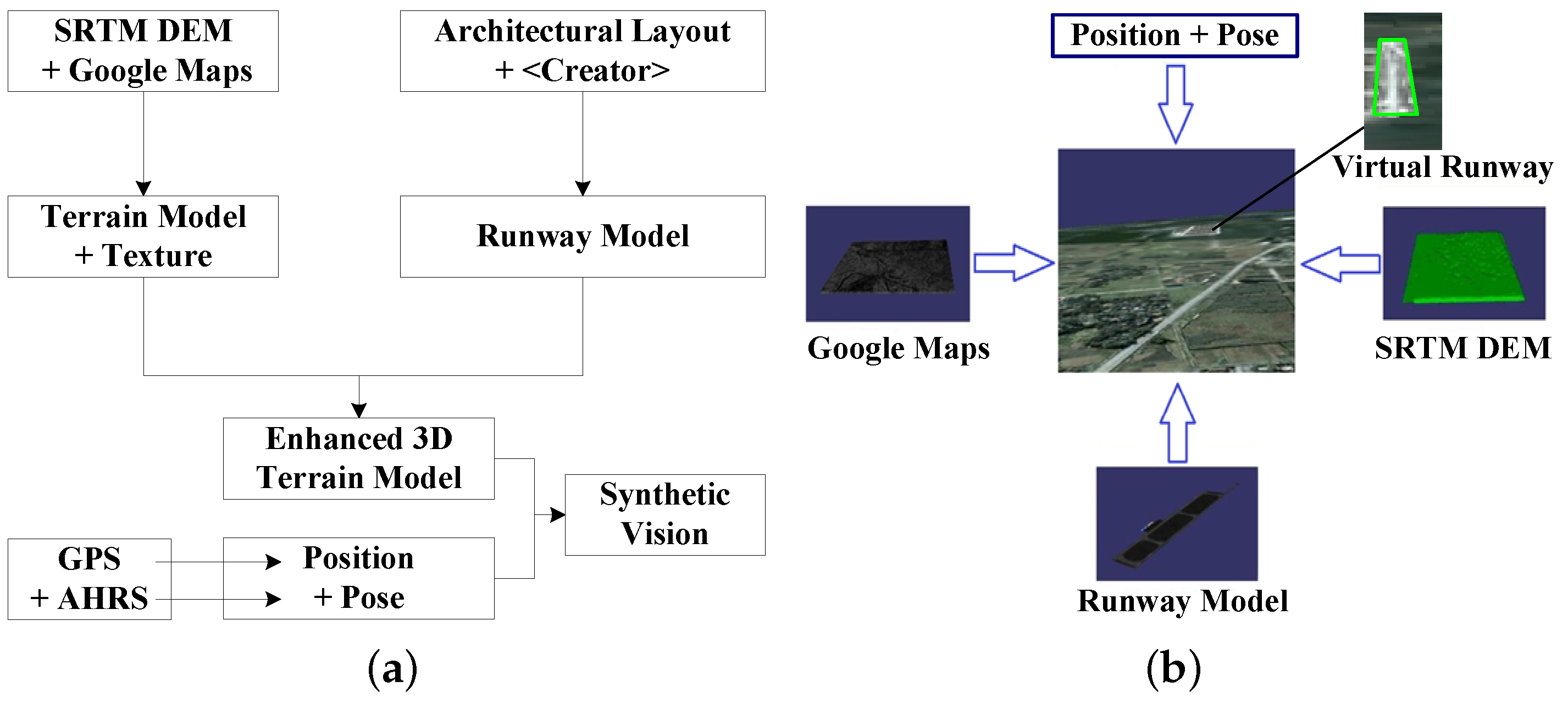
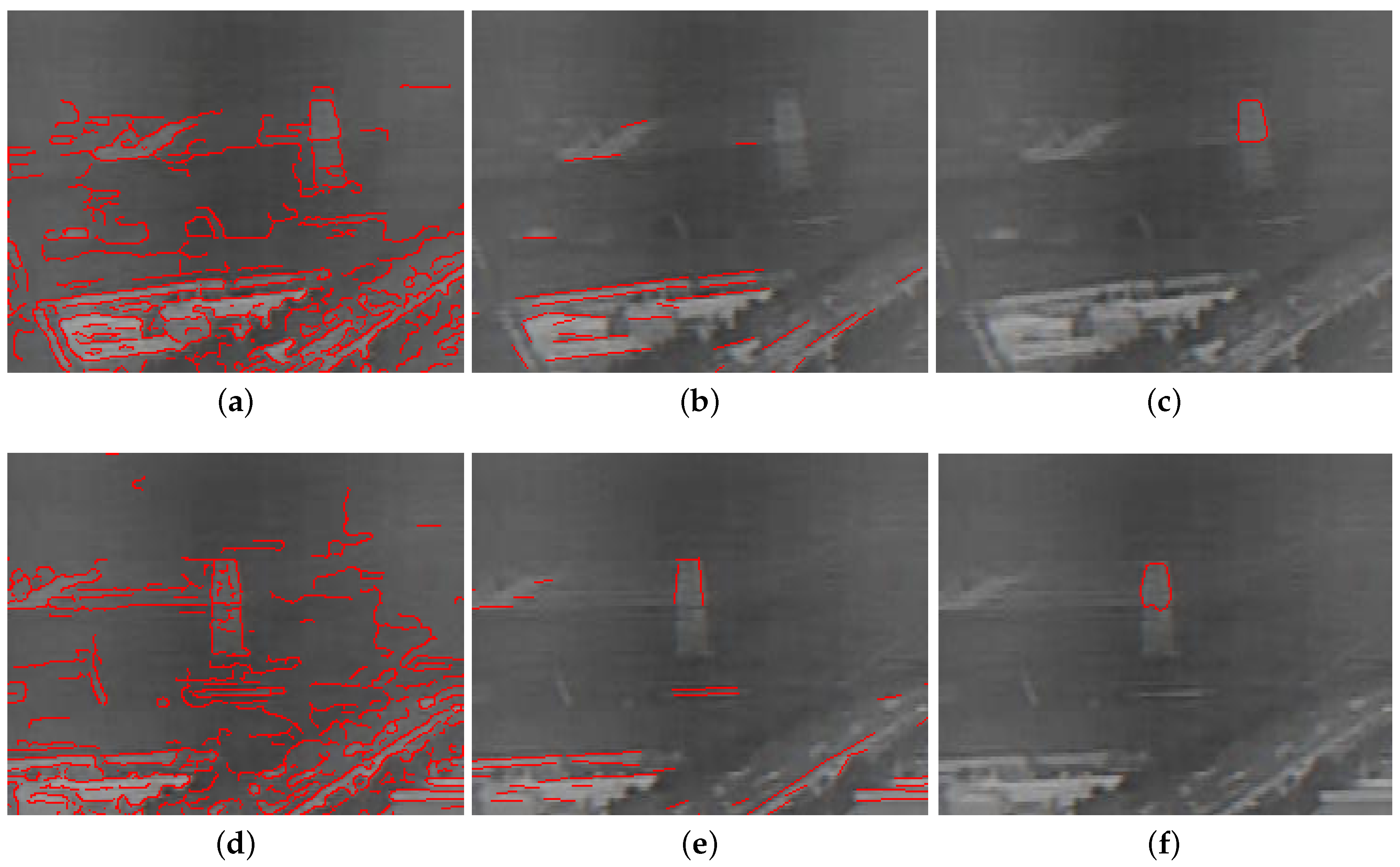
- Locating a virtual runway using heuristic search to find out a subset of runways from infrared images. We generalize Otsu’s thresholding method to trichotomize the region overlapping a virtual runway, one of which is used as the initial contour in a level set method.
- (2)
- An ROI based level set method is proposed, which makes it possible to detect a runway in real time.
- (3)
- Shape of the virtual runway provides a rough area of the actual runway, which imposes a stopping strategy for evolution in the level set method.
2. Generation of Virtual Runway
3. Real-Time Runway Detection Based on ROI Level Set Method
3.1. Three-Thresholding Segmentation for Initial Contour
3.2. ROI Based Implementation for the Level Set Method
3.3. Stopping Criteria
4. Analysis of Results and Comparisons
4.1. Analysis of Proposed Runway Detection
- (1)
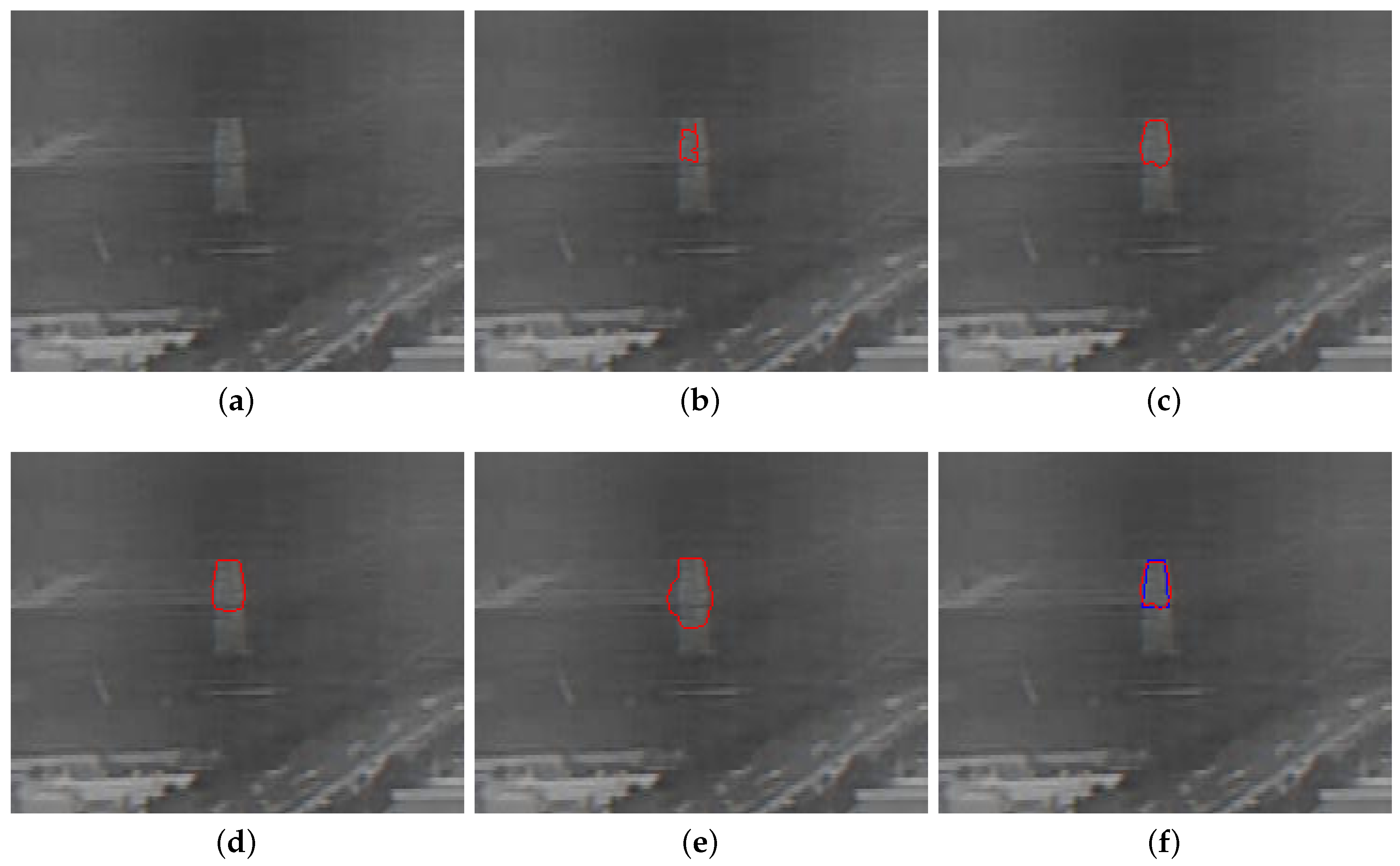
- The error of the initial contour . It is apparent that, if the initial contour lies in the range of the ground truth, it is appropriate for the proposed method. For the error in the initial contour, we employ a “one-vote negation evaluation strategy”, namely, we define the initial error if all the points of an initial contour lie within the ground truth; otherwise, .
- (2)
- The error of the final contour . The distance between the points of the final contour and the ground truth reflects the accuracy of the proposed method [39]. Thus, we define the final error as follows:where the function returns a signed distance between the point in the final contour and the nearest ground truth edge. Based on the premise that the manually drawn ground truth is sufficiently precise, it is obvious that the smaller the is, the more accurate the runway detection is.
- (3)
- The area differece . Jaccard Similarity measure calculates [40] the similarity in the G ground truth area and the D detected area. In this measurement, the maximum value 1 means completly similar, while 0 means completely dissimilar. Naturally, we defined the third error index, given as below:
4.2. Comparison with Existing Methods
5. Conclusions
Author Contributions
Funding
Acknowledgments
Conflicts of Interest
References
- Knabl, P.; Schmerwitz, S.; Doehler, H.U. Target Detection with Helmet-Mounted Displays in Low Visibility Helicopter Operations. Procedia Manuf. 2015, 3, 2558–2565. [Google Scholar] [CrossRef]
- Cornejo-Bueno, L.; Casanova-Mateo, C.; Sanz-Justo, J.; Cerro-Prada, E.; Salcedo-Sanz, S. Efficient Prediction of Low-Visibility Events at Airports Using Machine-Learning Regression. Bound.-Layer Meteorol. 2017, 165, 349–370. [Google Scholar] [CrossRef]
- Stoltny, M. Instrument Landing System as an Example of a Precision Approach System. Sci. J. Silesian Univ. Technol. 2016, 93, 123–129. [Google Scholar] [CrossRef]
- Merkisz, J.; Galant, M.; Bieda, M. Analysis of Operating Instrument Landing System Accuracy under Simulated Conditions. Sci. J. Silesian Univ. Technol. 2017, 94, 163–173. [Google Scholar] [CrossRef]
- Kramer, L.J.; Etherington, T.J.; Severance, K.; Bailey, R.E.; Williams, S.P.; Harrison, S.J. Assessing Dual-Sensor Enhanced Flight Vision Systems to Enable Equivalent Visual Operations. J. Aerosp. Inf. Syst. 2017, 14, 1–18. [Google Scholar]
- Kumar, N.S.; Kashyap, S.K.; Naidu, V.; Gopalratnam, G. Integrated enhanced and synthetic vision system for transport aircraft. Def. Sci. J. 2013, 63, 157–163. [Google Scholar] [CrossRef]
- Mathew, J.K.; Major, W.L.; Hubbard, S.M.; Bullock, D.M. Statistical modelling of runway incursion occurences in the United States. J. Air Transp. Manag. 2017, 65, 54–62. [Google Scholar] [CrossRef]
- Song, I.; Cho, I.; Tessitore, T.; Gurcsik, T.; Ceylan, H. Data-Driven Prediction of Runway Incursions with Uncertainty Quantification. J. Comput. Civ. Eng. 2018, 32, 04018004. [Google Scholar] [CrossRef]
- Jackson, P.T.G.; Nelson, C.J.; Schiefele, J.; Obara, B. Runway detection in High Resolution remote sensing data. Phys. Rev. C 2015, 43, 96–104. [Google Scholar]
- Yao, X.; Han, J.; Guo, L.; Bu, S.; Liu, Z. A coarse-to-fine model for airport detection from remote sensing images using target-oriented visual saliency and CRF. Neurocomputing 2015, 164, 162–172. [Google Scholar] [CrossRef]
- Zhao, C.; Goshtasby, A.A. Registration of multitemporal aerial optical images using line features. ISPRS J. Photogramm. Remote Sens. 2016, 117, 149–160. [Google Scholar] [CrossRef]
- Penariu, P.S.; Bodorin, N.P.; Stroescu, V.C.; Penariu, P.S.; Bodorin, N.P.; Stroescu, V.C.; Penariu, P.S.; Bodorin, N.P.; Stroescu, V.C. A Parallel Approach on Airport Runways Detection Using MPI and CImg; Springer: Berlin, Germany, 2018; pp. 460–471. [Google Scholar]
- Gioi, R.G.V.; Jakubowicz, J.; Morel, J.M.; Randall, G. LSD: A Fast Line Segment Detector with a False Detection Control. IEEE Trans. Pattern Anal. Mach. Intell. 2010, 32, 722–732. [Google Scholar] [CrossRef] [PubMed]
- Gioi, R.G.V.; Jakubowicz, J.; Morel, J.M.; Randall, G. LSD: A line segment detector. Image Process. Line 2012, 2, 35–55. [Google Scholar] [CrossRef]
- Akinlar, C.; Topal, C. EDLines: A real-time line segment detector with a false detection control. Pattern Recognit. Lett. 2011, 32, 1633–1642. [Google Scholar] [CrossRef]
- Aytekin, Ö.; Zongur, U.; Halici, U. Texture-based airport runway detection. IEEE Geosci. Remote Sens. Lett. 2013, 10, 471–475. [Google Scholar] [CrossRef]
- Cheng, G.; Han, J.; Zhou, P.; Guo, L. Multi-class geospatial object detection and geographic image classification based on collection of part detectors. ISPRS J. Photogramm. Remote Sens. 2014, 98, 119–132. [Google Scholar] [CrossRef]
- Cheriyadat, A.M. Unsupervised feature learning for aerial scene classification. IEEE Trans. Geosci. Remote Sens. 2014, 52, 439–451. [Google Scholar] [CrossRef]
- Zhang, F.; Du, B.; Zhang, L. Saliency-guided unsupervised feature learning for scene classification. IEEE Trans. Geosci. Remote Sens. 2015, 53, 2175–2184. [Google Scholar] [CrossRef]
- Cheng, G.; Han, J. A survey on object detection in optical remote sensing images. ISPRS J. Photogramm. Remote Sens. 2016, 117, 11–28. [Google Scholar] [CrossRef]
- Marapareddy, R.; Saripalli, S.W. Runway Detection Using K-Means Clustering Method Using UAVSAR Data. In Proceedings of the International Conference on Artificial Intelligence and Applications (AIAPP), Geneva, Switzardland, 25–26 March 2017; pp. 49–54. [Google Scholar]
- Cheng, G.; Zhou, P.; Han, J. Learning Rotation-Invariant Convolutional Neural Networks for Object Detection in VHR Optical Remote Sensing Images. IEEE Trans. Geosci. Remote Sens. 2016, 54, 7405–7415. [Google Scholar] [CrossRef]
- Li, K.; Cheng, G.; Bu, S.; You, X. Rotation-Insensitive and Context-Augmented Object Detection in Remote Sensing Images. IEEE Trans. Geosci. Remote Sens. 2018, 56, 2337–2348. [Google Scholar] [CrossRef]
- Wang, J.; Cheng, Y.; Xie, J.; Niu, W. A Real-Time Sensor Guided Runway Detection Method for Forward-Looking Aerial Images. In Proceedings of the 2015 11th International Conference on Computational Intelligence and Security (CIS), Shenzhen, China, 19–20 December 2015; pp. 150–153. [Google Scholar]
- Zhang, L.; Cheng, Y.; Zhai, Z.; Zhang, L.; Cheng, Y.; Zhai, Z.; Zhang, L.; Cheng, Y.; Zhai, Z. Real-time accurate runway detection based on airborne multi-sensors fusion. Def. Sci. J. 2017, 67, 542–550. [Google Scholar] [CrossRef]
- Osher, S.; Sethian, J.A. Fronts propagating with curvature-dependent speed: Algorithms based on Hamilton-Jacobi formulations. J. Comput. Phys. 1988, 79, 12–49. [Google Scholar] [CrossRef]
- Li, C.; Xu, C.; Gui, C.; Fox, M.D. Level set evolution without re-initialization: A new variational formulation. In Proceedings of the IEEE Computer Society Conference on Computer Vision and Pattern Recognition (CVPR), San Diego, CA, USA, 20–25 June 2005; Volume 1, pp. 430–436. [Google Scholar]
- Shi, Y.; Karl, W.C. A fast level set method without solving PDEs. In Proceedings of the 30th International Conference on Acoustics, Speech, and Signal Processing (ICASSP), Philadelphia, PA, USA, 23 March 2005; pp. 97–100. [Google Scholar]
- Shi, Y.; Karl, W.C. A real-time algorithm for the approximation of level-set-based curve evolution. IEEE Trans. Image Process. 2008, 17, 645–656. [Google Scholar] [PubMed]
- Robinson, N.; Regetz, J.; Guralnick, R.P. EarthEnv-DEM90: A nearly-global, void-free, multi-scale smoothed, 90 m digital elevation model from fused ASTER and SRTM data. ISPRS J. Photogramm. Remote Sens. 2014, 87, 57–67. [Google Scholar] [CrossRef]
- Peng, J.; Zhang, Y.; Shan, J. Shading-based DEM refinement under a comprehensive imaging model. ISPRS J. Photogramm. Remote Sens. 2015, 110, 24–33. [Google Scholar] [CrossRef]
- Shean, D.E.; Alexandrov, O.; Moratto, Z.M.; Smith, B.E.; Joughin, I.R.; Porter, C.; Morin, P. An automated, open-source pipeline for mass production of digital elevation models (DEMs) from very-high-resolution commercial stereo satellite imagery. ISPRS J. Photogramm. Remote Sens. 2016, 116, 101–117. [Google Scholar] [CrossRef]
- Lee, I.K.; Shamsoddini, A.; Li, X.; Trinder, J.C.; Li, Z. Extracting hurricane eye morphology from spaceborne SAR images using morphological analysis. ISPRS J. Photogramm. Remote Sens. 2016, 117, 115–125. [Google Scholar] [CrossRef]
- Soilán, M.; Riveiro, B.; Martínez-Sánchez, J.; Arias, P. Segmentation and classification of road markings using MLS data. ISPRS J. Photogramm. Remote Sens. 2017, 123, 94–103. [Google Scholar] [CrossRef]
- Otsu, N. A threshold selection method from gray-level histograms. Automatica 1975, 11, 23–27. [Google Scholar] [CrossRef]
- Fukunaga, K. Introduction to Statistical Pattern Recognition; Academic Press: Cambridge, MA, USA, 2013. [Google Scholar]
- Korn, G.A.; Korn, T.M. Mathematical Handbook for Scientists and Engineers: Definitions, Theorems, and Formulas for Reference and Review; Courier Corporation: North Chelmsford, MA, USA, 2000. [Google Scholar]
- Malladi, R.; Sethian, J.A.; Vemuri, B.C. Shape modeling with front propagation: A level set approach. IEEE Trans. Pattern Anal. Mach. Intell. 1995, 17, 158–175. [Google Scholar] [CrossRef]
- Cheng, I.; Flores-Mir, C.; Major, P.; Basu, A. Measuring and evaluating ground truth for boundary detection in medical images. In Proceedings of the 2008 30th Annual International Conference of the IEEE Engineering in Medicine and Biology Society, Vancouver, BC, Canada, 20–25 August 2008; pp. 5889–5892. [Google Scholar]
- Jain, A.; Jain, A.; Chauhan, N.; Singh, V.; Thakur, N. Information Retrieval using Cosine and Jaccard Similarity Measures in Vector Space Model. Int. J. Comput. Appl. 2017, 164, 28–30. [Google Scholar] [CrossRef]
- Chan, T.F.; Sandberg, B.Y.; Vese, L.A. Active contours without edges for vector-valued images. J. Vis. Commun. Image Represent. 2000, 11, 130–141. [Google Scholar] [CrossRef]
- Chan, T.F.; Vese, L.A. Active contours without edges. IEEE Trans. Image Process. 2001, 10, 266–277. [Google Scholar] [CrossRef] [PubMed]
- Balla-Arabe, S.; Gao, X.; Wang, B. A fast and robust level set method for image segmentation using fuzzy clustering and lattice Boltzmann method. IEEE Trans. Cybern. 2013, 43, 910–920. [Google Scholar] [CrossRef] [PubMed]
- Yang, Y.; Newsam, S. Geographic image retrieval using local invariant features. IEEE Trans. Geosci. Remote Sens. 2013, 51, 818–832. [Google Scholar] [CrossRef]


| Image Dimension | h | ∆x | ∆y | |||||||
|---|---|---|---|---|---|---|---|---|---|---|
| 720 × 576 | 1.5 | 3 | 1.5 | 0.06 | −4.0 | 4.0 | 1.5 | 1 | 15 | 15 |
| Sequence Number | (pel) | Proposed Method | Ground Truth |
|---|---|---|---|
| 100 | 3.11 |  |  |
| 84 | 2.62 |  |  |
| 97 | 2.57 |  |  |
| 16 | 2.57 |  |  |
| 75 | 2.47 |  |  |
| Processing Time | Min | Max | Average |
|---|---|---|---|
| Li’s Method [27] | 0.172 | 1.844 | 0.821 |
| Proposed Method | 0.015 | 0.063 | 0.035 |
© 2018 by the authors. Licensee MDPI, Basel, Switzerland. This article is an open access article distributed under the terms and conditions of the Creative Commons Attribution (CC BY) license (http://creativecommons.org/licenses/by/4.0/).
Share and Cite
Liu, C.; Cheng, I.; Basu, A. Real-Time Runway Detection for Infrared Aerial Image Using Synthetic Vision and an ROI Based Level Set Method. Remote Sens. 2018, 10, 1544. https://doi.org/10.3390/rs10101544
Liu C, Cheng I, Basu A. Real-Time Runway Detection for Infrared Aerial Image Using Synthetic Vision and an ROI Based Level Set Method. Remote Sensing. 2018; 10(10):1544. https://doi.org/10.3390/rs10101544
Chicago/Turabian StyleLiu, Changjiang, Irene Cheng, and Anup Basu. 2018. "Real-Time Runway Detection for Infrared Aerial Image Using Synthetic Vision and an ROI Based Level Set Method" Remote Sensing 10, no. 10: 1544. https://doi.org/10.3390/rs10101544
APA StyleLiu, C., Cheng, I., & Basu, A. (2018). Real-Time Runway Detection for Infrared Aerial Image Using Synthetic Vision and an ROI Based Level Set Method. Remote Sensing, 10(10), 1544. https://doi.org/10.3390/rs10101544


