Building the Green Infrastructure of Belgrade: The Importance of Community Greening


Abstract
:1. Introduction
2. Case Studies
2.1. Methods
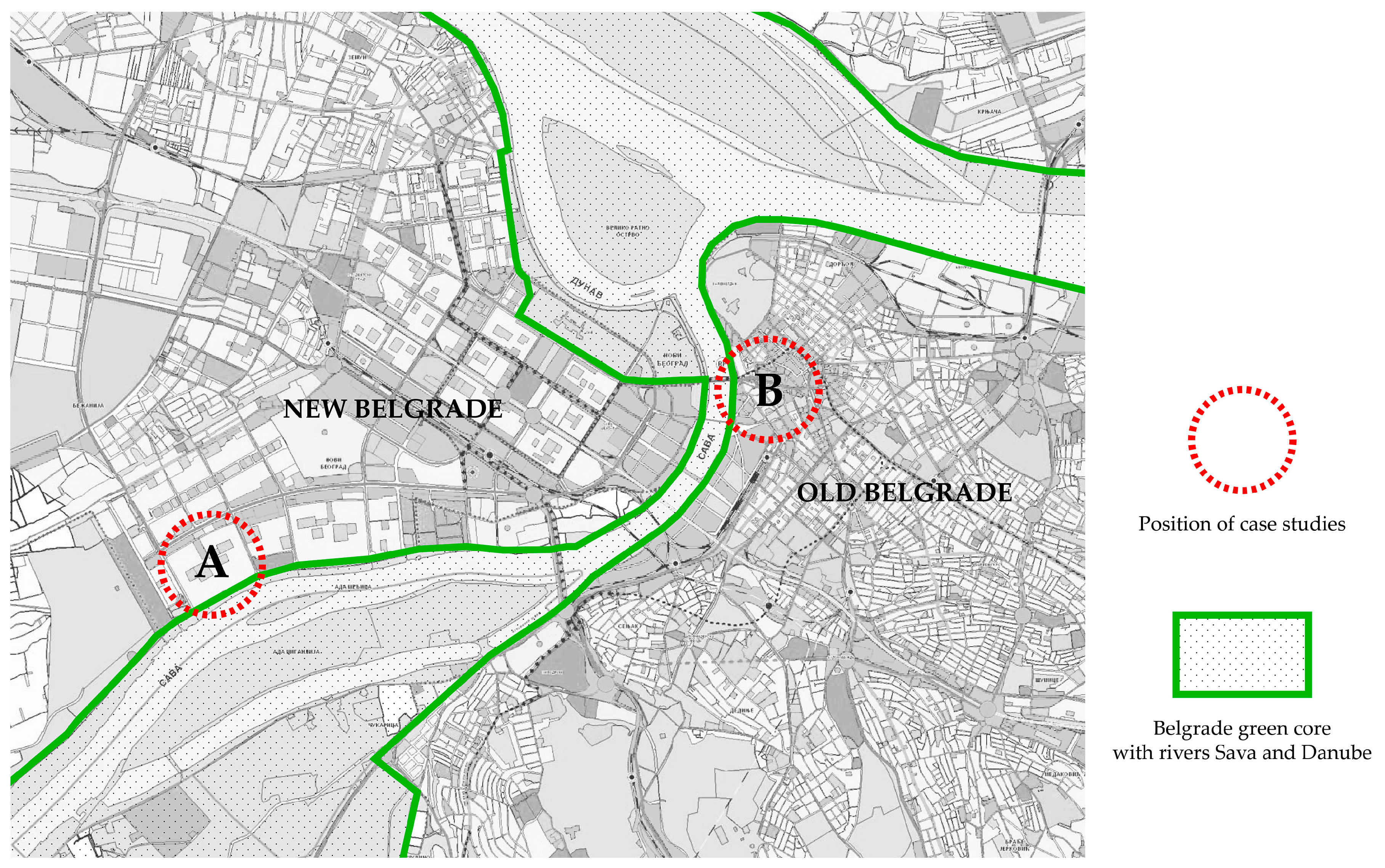
2.2. Study Areas
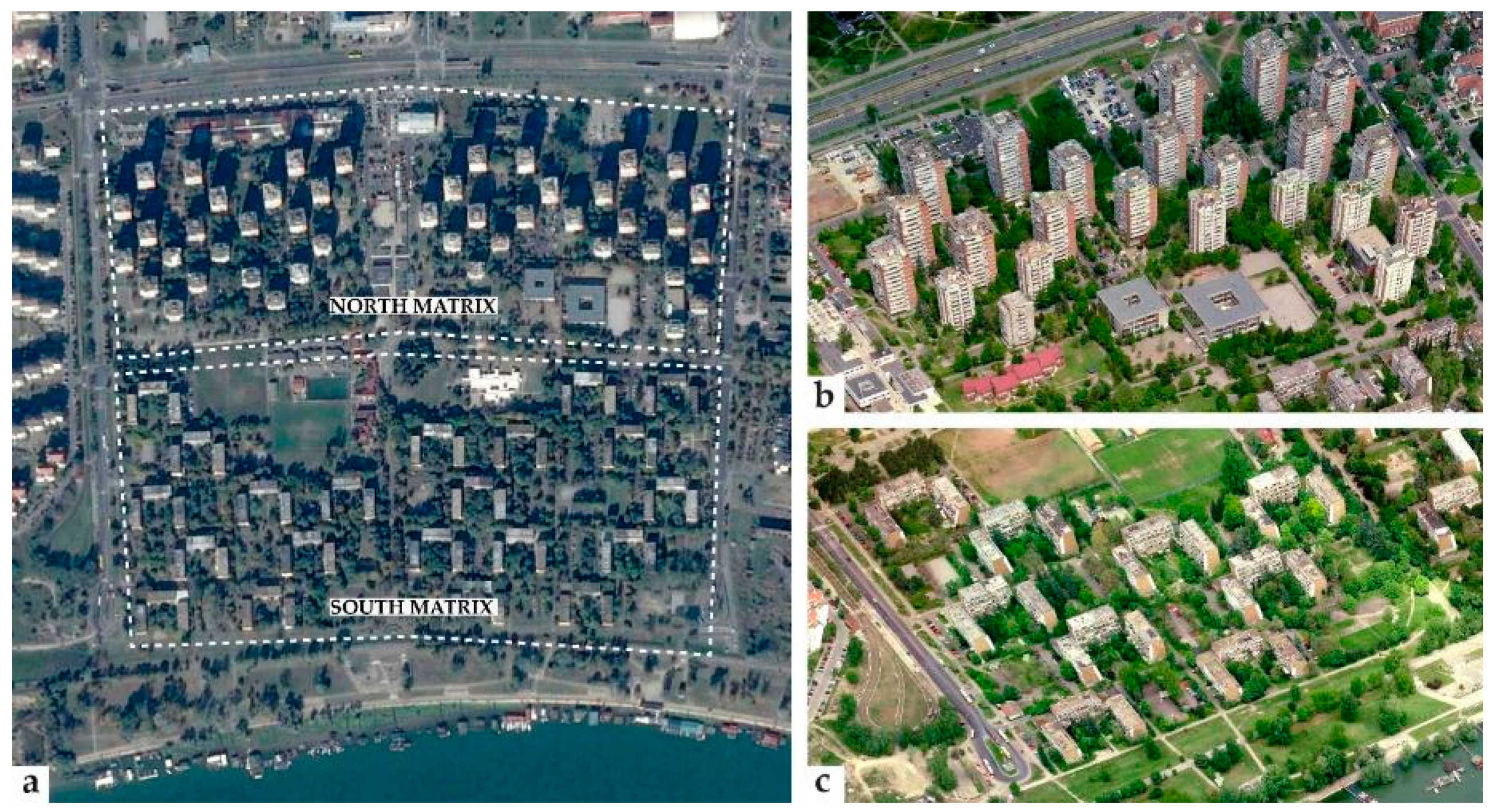
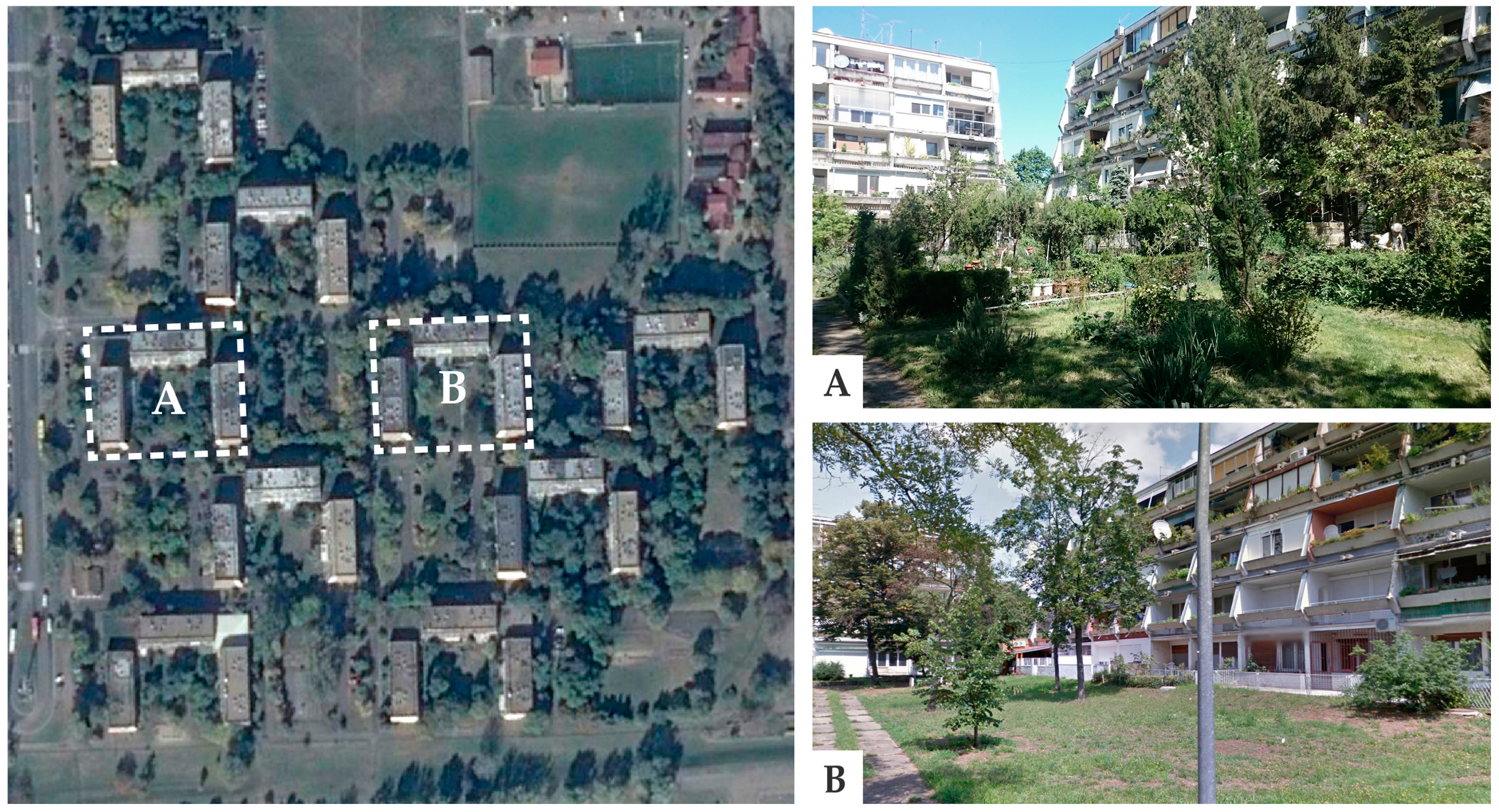
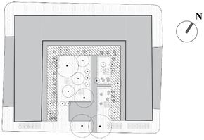
2.2.1. Block 45
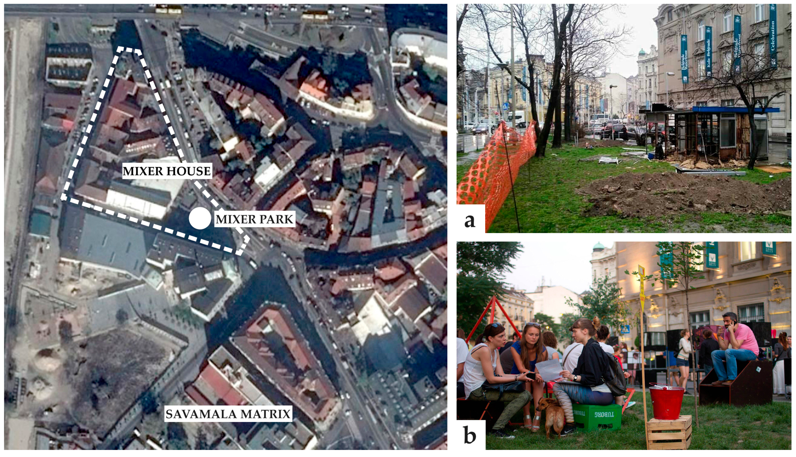
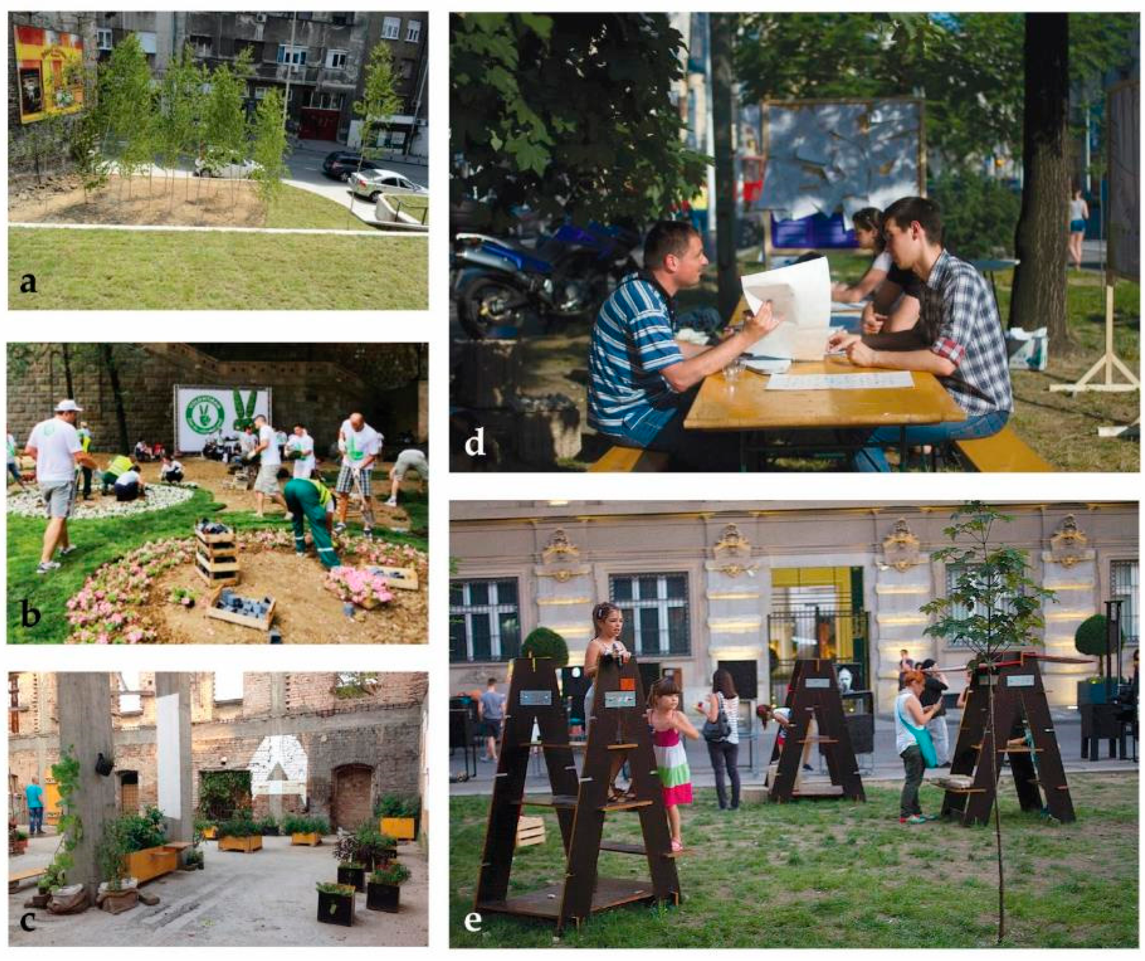
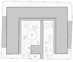
2.2.2. Savamala
3. Results
4. Discussion
5. Conclusions
Acknowledgments
Author Contributions
Conflicts of Interest
References
- Pelkonen, V.; Kohl, J. The role of local ecological knowledge in sustainable urban planning: Perspectives from Finland. Sustain. Sci. Pract. Policy 2005, 1, 3–14. [Google Scholar]
- Pelkonen, V.; Niemelä, J. Linking ecological and social systems in cities: Urban planning in Finland as a case. Biodivers. Conserv. 2005, 14, 1947–1967. [Google Scholar] [CrossRef]
- Wilson, E.; Piper, J. Spatial Planning and Climate Change; Routledge: London, UK, 2010. [Google Scholar]
- Pickett, S.T.A.; Cadenasso, M.L.; Grove, J.M. Resilient cities: Meaning, models, and metaphor for integrating the ecological, socioeconomic, and planning realms. Land Urban Plan. 2004, 69, 69–384. [Google Scholar] [CrossRef]
- Ahern, J. Green infrastructure for cities: The spatial dimension. In Cities of the Future towards Integrated Sustainable Water and Landscape Management; Novotny, V., Brown, P., Eds.; IWA Publishing: London, UK, 2007; pp. 267–283. [Google Scholar]
- Benedict, M.A.; McMahon, E.T. Green Infrastructure: Smart Conservation for the 21st Century; The Conservation Fund and Sprawl Watch Clearinghouse: Arlington, VA, USA, 2002. [Google Scholar]
- Raven, J. Cooling the Public Realm: Climate-Resilient Urban Design. In Resilient Cities: Cities and Adaptation to Climate Change; Zimmermann, K., Ed.; Springer: Heidelberg, Germany, 2011; pp. 451–463. [Google Scholar]
- Tidball, K.G.; Krasny, M.E. From risk to resilience: What role for community greening and civic ecology in cities? In Social learning towards a More Sustainable World; Wals, A.E.J., Ed.; Wageningen Academic Publishers: Wageningen, The Netherlands, 2009; pp. 149–165. [Google Scholar]
- Gill, S.E.; Handley, J.F.; Ennos, A.R.; Pauliet, S. Adapting Cities for Climate Change: The Role of Green Infrastructure. Built Environ. 2007, 33, 115–133. [Google Scholar] [CrossRef]
- Ndubisi, F. Ecological Planning: A Historical and Comparative Synthesis; Johns Hopkins University Press: Baltimore, MD, USA, 2002. [Google Scholar]
- Irvine, K.N.; Fuller, R.A.; Devine-Wright, P.; Tratalos, J.; Payne, S.R.; Warren, P.H.; Lomas, K.J.; Gaston, K.J. Ecological and Psychological Value of Urban Green Space. In Dimensions of Sustainable City, Future City 2; Jenks, M., Jones, C., Eds.; Springer: London, UK, 2010; pp. 215–237. [Google Scholar]
- Lafortezza, R.; Davies, C.; Sanesi, G.; Konijnendijk, C. Green Infrastructure as a tool to support spatial planning in European urban regions. iForest 2013, 6, 102–108. Available online: http://www.sisef.it/iforest/contens/?id’ifor0723–006 (accessed on 5 March 2013). [CrossRef]
- Lovell, S.T.; Taylor, J.R. Supplying urban ecosystem services through multifunctional green infrastructure in the United States. Land Ecol. 2013, 28, 1447–1463. [Google Scholar] [CrossRef]
- Zaręba, A. Multifunctional and Multiscale Aspects of Green Infrastructure in Contemporary Research. Prob. Sust. Dev. 2014, 9, 149–156. [Google Scholar]
- Senate Department for the Environment, Transport and Climate Protection. Biotope Area Factor (BAF). 1990. Available online: http://www.stadtentwicklung.berlin.de/umwelt/landschaftsplanung/bff/index_en.shtml (accessed on 10 September 2016).
- Kruuse, A. The Green Space Factor and the Green Points System. 2011. Available online: http://www.malmö.se/download/18.d8bc6b31373089f7d980008924/1491301018437/greenspacefactor_greenpoints_grabs.pdf (accessed on 10 September 2016.).
- Hirst, J. Seattle Green Factor (SGF). 2008. Available online: http://www.asla.org/2010awards/519.html (accessed on 2 August 2016).
- Krasny, M.E.; Tidball, K.G. Civic Ecology: Adaptation and Transformation from the Ground Up; MIT Press: Cambridge, MA, USA, 2015. [Google Scholar]
- Colding, J.; Barthel, S. The potential of ‘Urban Green Commons’ in the resilience building of cities. Ecol. Econ. 2013, 86, 156–166. [Google Scholar] [CrossRef]
- Pietrzyk-Kaszynska, A.; Czepkiewicz, M.; Kronenberg, J. Eliciting non-monetary values of formal and informal urban green spaces using public participation GIS. Land. Urban Plan. 2017, 160, 85–95. [Google Scholar] [CrossRef]
- Kinzig, A.; Warren, P.; Martin, C.; Hope, D.; Katti, M. The effects of human socioeconomic status and cultural characteristics on urban patterns of biodiversity. Ecol. Soc. 2005, 10. Available online: http://www.ecologyandsociety.org/vol10/iss1/art23/ (accessed on 17 June 2016). [CrossRef]
- Master Plan of Belgrade to 2021. 2016. Available online: http://www.urbel.com/default.aspx?ID=uzb_GeneralniPlanovi&LN=SRL (accessed on 17 December 2015).
- City of Belgrade Development Strategy (CBDS) 2011–2016 (Strategija razvoja grada Beograda 2011–2016). 2010. Available online: http://www.beograd.rs/download.php/documents/SRGBpredlog.pdf (accessed on 28 May 2016).
- Cvejić, J. Local ecological action plan (LEAP) of Savski Venac Municipality (Lokalni Ekološki Akcioni Plan Gradske Opštine Savski Venac). 2010. Available online: http://www.savskivenac.rs/ekoppt/2010-4.pps (accessed on 18 May 2016).
- Cvejić, J.; Bajc, Lj. Zelena Regulativa Beograda (Green regulation of Belgrade). 2003. Available online: http://www.urbel.com/documents/zelena_regulativa_beograd.pdf (accessed on 18 May 2016).
- MapSoft. Geographical Information System (GIS) of Biotopes of Belgrade. 2008. Available online: https://gisbiotopa.beograd.gov.rs/Map (accessed on 18 May 2016).
- Forman, R. Land Mosaics: The Ecology of Landscapes and Regions; Cambridge University Press: London, UK, 1995. [Google Scholar]
- Cvejić, J.; Teofilović, A. Concept of Green Spaces System—Belgrade Case Study. In Proceedings of the Fabos Conference on Landscape and Greenway Planning, Budapest, Hungary, 8–11 July 2010; pp. 171–178. [Google Scholar]
- Teofilović, A.; Cvejić, J.; Tutundžić, A. Program za Urbanistički Plan Sistema Zelenih Površina Beograda, Projekat “Zelena regulativa Beograda” (IV faza); Urbanistički Zavod Beograda: Belgrade, Serbia, 2009. [Google Scholar]
- Đokić, N.; Grujić, M. Action Plan for Climate Change Adaptation for City of Belgrade. 2015. Available online: http://klimatskepromenebeograd.rs/wp-content/uploads/2015/11/Climate-Change-Adaptation-Action-Plan.pdf (accessed on 28 April 2016).
- Forman, R.T.T.; Godron, M. Landscape ecology; John Wiley & Sons: New York, NY, USA, 1986. [Google Scholar]
- Cvejić, J.; Bobić, A.; Teofilović, A.; Tutundžić, A.; Radulović, S. Adaptacija Kompaktnog grada na Klimatske Promene: Primena Ekološkog Modela u Beogradu. In Uticaj Klimatskih Promena na Planiranje i Projektovanje; Đokić, V., Lazović, Z., Eds.; Faculty of Architecture: Belgrade, Serbia, 2012; pp. 83–109. [Google Scholar]
- Master Plan of Belgrade 1950; Urban Planning Institute of Belgrade: Belgrade, Serbia, 1950.
- Draft of the Detailed Regulation Plan for Blocks 45 and 70; Urban Planning Institute of Belgrade: Belgrade, Serbia, 2003.
- Graovac, A.; Teofilović, V.; Lalić, I. Dve strane Planerske Medalje: Planovi Detaljne Regulacije za Blokove 45 i 70 u Novom Beogradu. 2015. Available online: http://www.ingkomora.org.rs/materijalpo/download/2015/20150320_dve_strane_planerske_medalje.pdf (accessed on 22 July 2016).
- Stanojković, M. Oasis between Blocks on New Belgrade. 2016. Available online: http://www.novosti.rs/vesti/lifestyle.677.html:633910-Oaza-medju-blokovima-na-Novom-Beogradu (accessed on 22 July 2016).
- Mapping and Evaluating Biotopes of Belgrade (Kartiranje i Vrednovanje Biotopa Beograda). 2007. Available online: http://www.urbel.com/documents/info20-tema.pdf (accessed on 28 May 2016).
- Blue-green dream. 2014. Available online: http://www.slideshare.net/NALED/the-story-of-mikser (accessed on 28 June 2016).
- Zdravamala (Healthy Savamala). 2015. Available online: http://urbanincubator.org/portfolio_page/zdravamala/ (accessed on 18 May 2016).
- My piece of Savamala—City Guerilla (Moje parče Savamale—Gradska gerila). 2015. Available online: http://festival.mikser.rs/en/project/my-piece-of-savamala/ (accessed on 28 May 2016).
- Kertesz, M. Contemporary Architecture Center organization (KÉK)-Community Gardens. 2016. Available online: http://kek.org.hu/en/projekt/kertek/ (accessed on 22 July 2016).
- Zoidl, F. Vienna Review—Urban Gardening. 2013. Available online: http://www.viennareview.net/services/keys-to-the-city/urban-gardening (accessed on 22 July 2016.).


| Floor Space Index | Population Density | Building Coverage (%) | Green Area (%) | |
|---|---|---|---|---|
| Block 45 | 1.2–2.2 | 300–600/ha | 30 | 30 |
| Savamala | 3.5–4.5 | 400–800/ha | 75 | 10 |
 |  |
| Built-up area (%) | 38.46 |
| Cultivation and maintenance | Mainly cultivated by self-organized residents; partially maintained by the public company—Belgrade’s City Greenery. |
| Pervious surface (%) | 44.69 |
| Evapotransp. surface (%) | 17.04 |
| Tree-covered surface (%) | 12.61 |
| Plant species richness (n) | ˃20 cultivated species including large trees (3), medium size trees (2), small trees (3), shrubs (3) and flowers (5) |
| Multi-functionality (n) | Greater diversity of greenery provides a number of activities related to biophilia, gardening, sport, leisure, children’s play, and activities with pets. |
| Visual quality | Richness of plant and animal species meets the residents’ aesthetic needs. |
 |  |
| Built-up area (%) | 38.46 |
| Cultivation and maintenance | Maintained by the public company—Belgrade’s City Greenery. |
| Pervious surface (%) | 45.10 |
| Evapotransp. surface (%) | 10.97 |
| Tree-covered surface (%) | 8.28 |
| Plant species richness (n) | <10 cultivated species: large trees (3), medium size trees (2), small trees (1), shrubs (2) |
| Multi-functionality (n) | Reduced diversity of activities due to the absence of gardens and other green spaces requiring active participation. |
| Visual quality | The lack of low vegetation, flowers, edible plants. Poorly-maintained trees contribute to the low attractiveness of space. |
 | 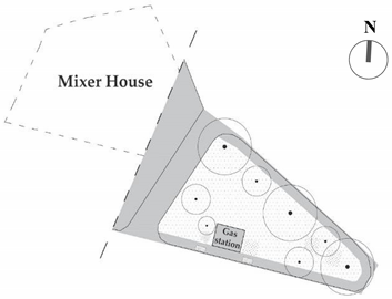 |
| Built-up area (%) | 2.40 |
| Cultivation and maintenance | Maintained by the public company—Belgrade’s City Greenery |
| Pervious surface (%) | 49.35 |
| Evapotranspirational surface (%) | 41.63 |
| Tree-covered surface (%) | 39.26 |
| Plant species richness (n) | Six cultivated species: large trees (2), medium size trees (2), small trees (1), shrubs (1) |
| Multi-functionality (n) | Gas station limits the potential use of space; reduced diversity of activities due to the absence of gardens and other green spaces that require active participation of local community. |
| Visual quality | Disrupted by petrol station. |
 | 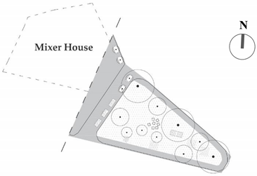 |
| Built-up area (%) | 0 |
| Cultivation and maintenance | Cultivated and maintained by public-private partnership, i.e., the cooperation between the public company—Belgrade’s City Greenery and “Mixer” organization. |
| Pervious surface (%) | 54.27 |
| Evapotranspirational surface (%) | 44.67 |
| Tree-covered surface (%) | 41.25 |
| Plant species richness (n) | <10 cultivated species: large trees (2), medium trees (3), small trees (1), shrubs (1), flowers (2) |
| Multi-functionality (n) | The removal of gas station enabled a number of activities related to the Mixer festival, workshops, public meetings, recreation, children’s activities. etc. |
| Visual quality | The lack of more diverse low vegetation and flowers, as well as poorly-maintained trees, contribute to the low attractiveness of the park. |
© 2017 by the authors. Licensee MDPI, Basel, Switzerland. This article is an open access article distributed under the terms and conditions of the Creative Commons Attribution (CC BY) license (http://creativecommons.org/licenses/by/4.0/).
Share and Cite
Simić, I.; Stupar, A.; Djokić, V. Building the Green Infrastructure of Belgrade: The Importance of Community Greening. Sustainability 2017, 9, 1183. https://doi.org/10.3390/su9071183
Simić I, Stupar A, Djokić V. Building the Green Infrastructure of Belgrade: The Importance of Community Greening. Sustainability. 2017; 9(7):1183. https://doi.org/10.3390/su9071183
Chicago/Turabian StyleSimić, Ivan, Aleksandra Stupar, and Vladan Djokić. 2017. "Building the Green Infrastructure of Belgrade: The Importance of Community Greening" Sustainability 9, no. 7: 1183. https://doi.org/10.3390/su9071183
APA StyleSimić, I., Stupar, A., & Djokić, V. (2017). Building the Green Infrastructure of Belgrade: The Importance of Community Greening. Sustainability, 9(7), 1183. https://doi.org/10.3390/su9071183