Construction and Use of a Simple Index of Urbanisation in the Rural–Urban Interface of Bangalore, India


Abstract
:1. Introduction
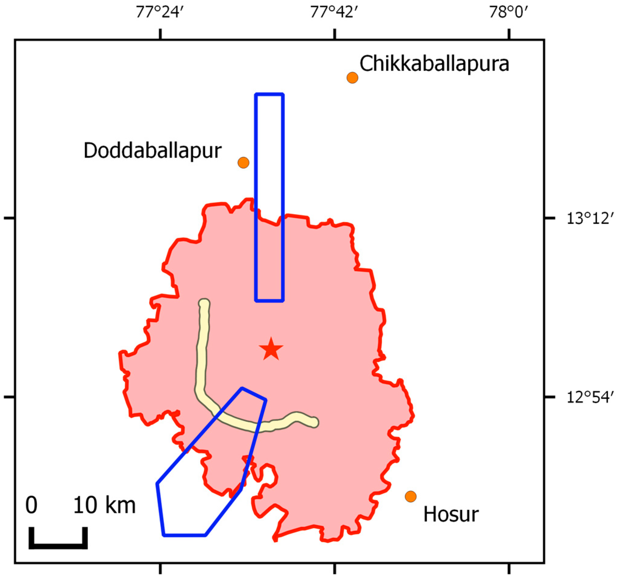
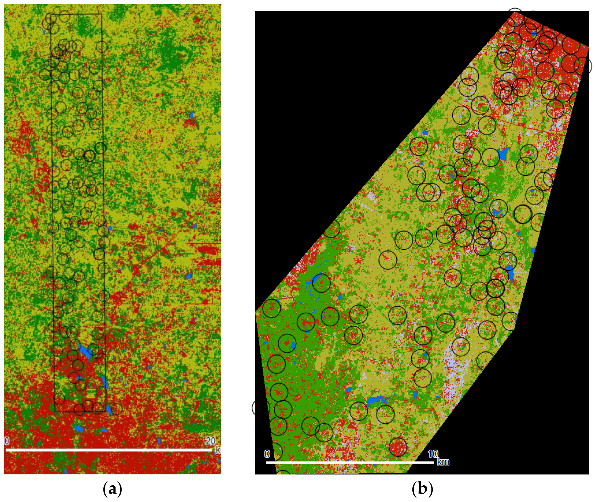
2. Materials and Methods
3. Results
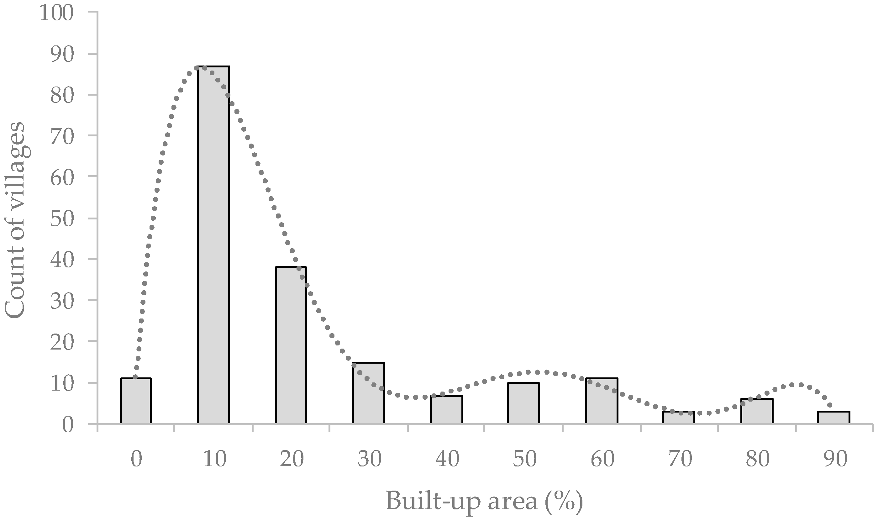
3.1. Proportion of Built-Up Area
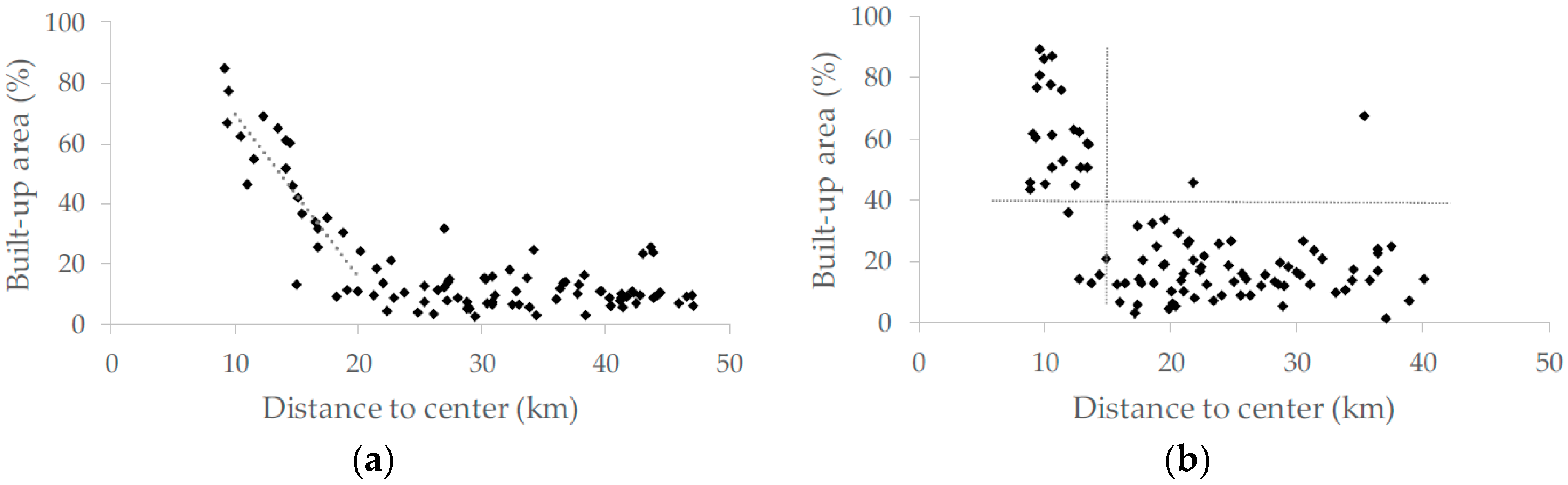
3.2. Distances
3.3. Correlation of Built-Up Area and Distance
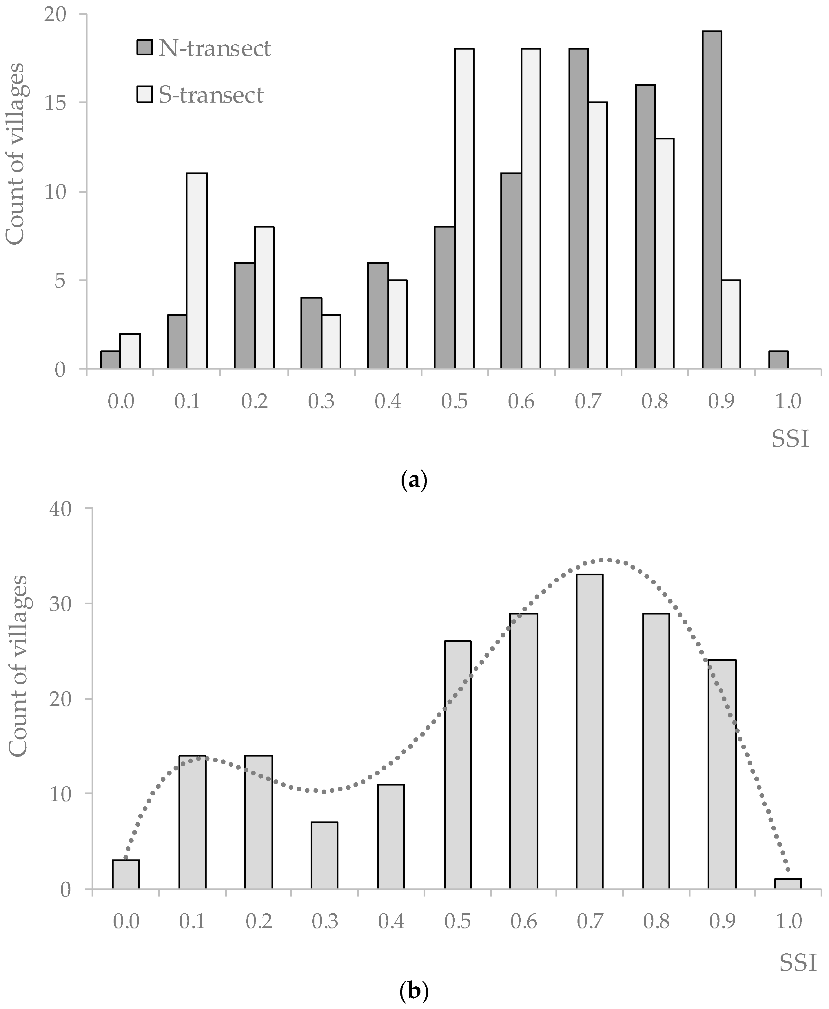
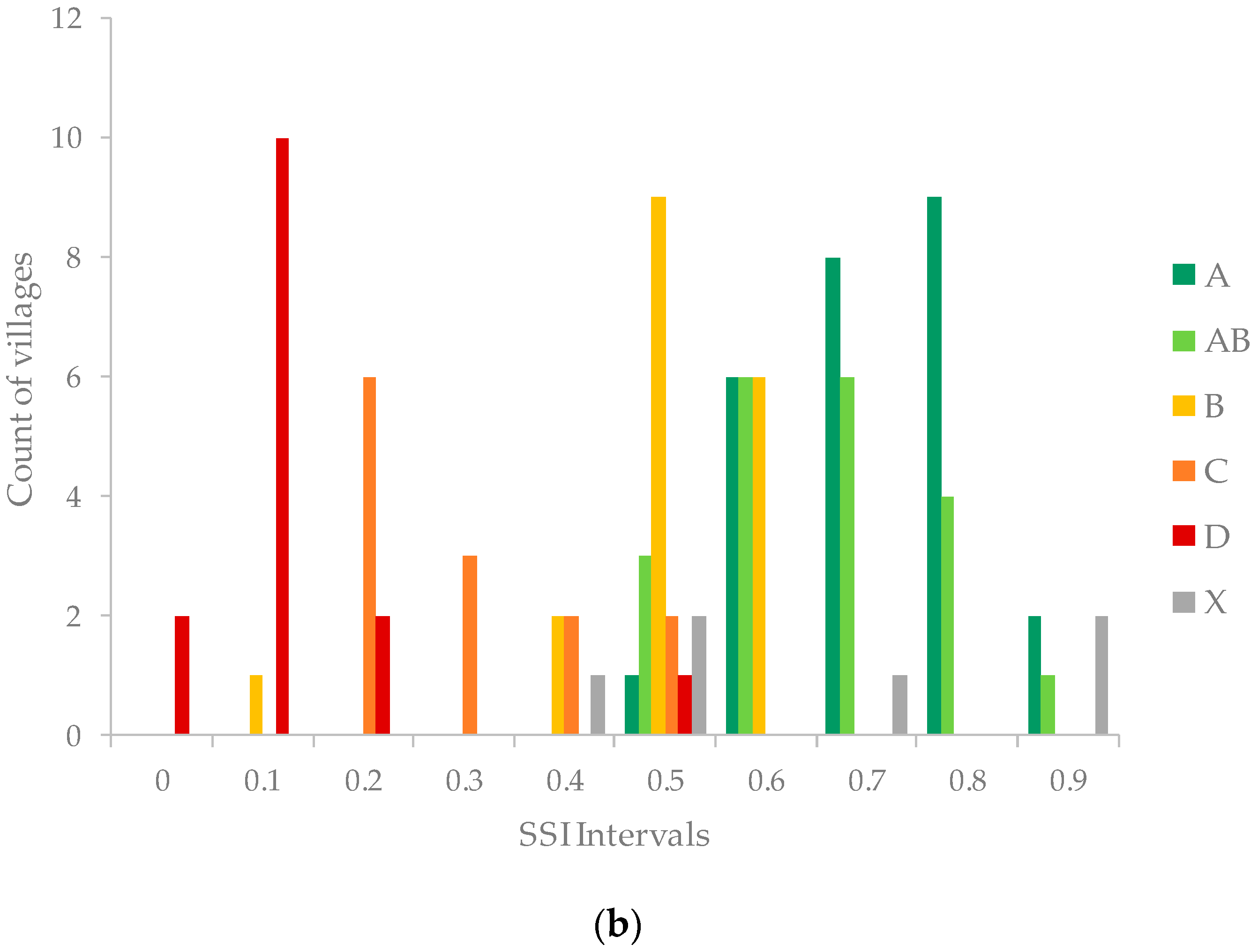
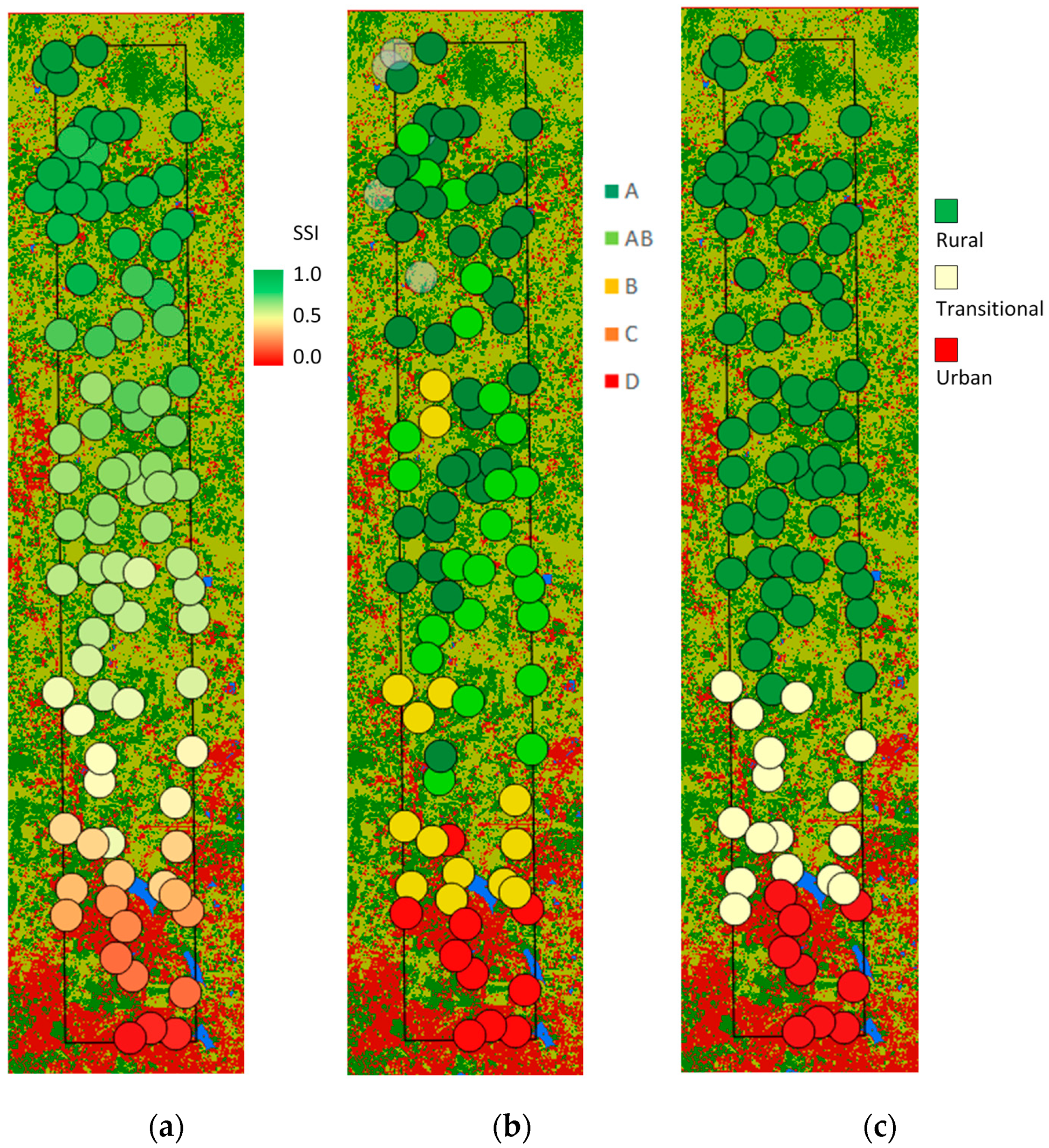
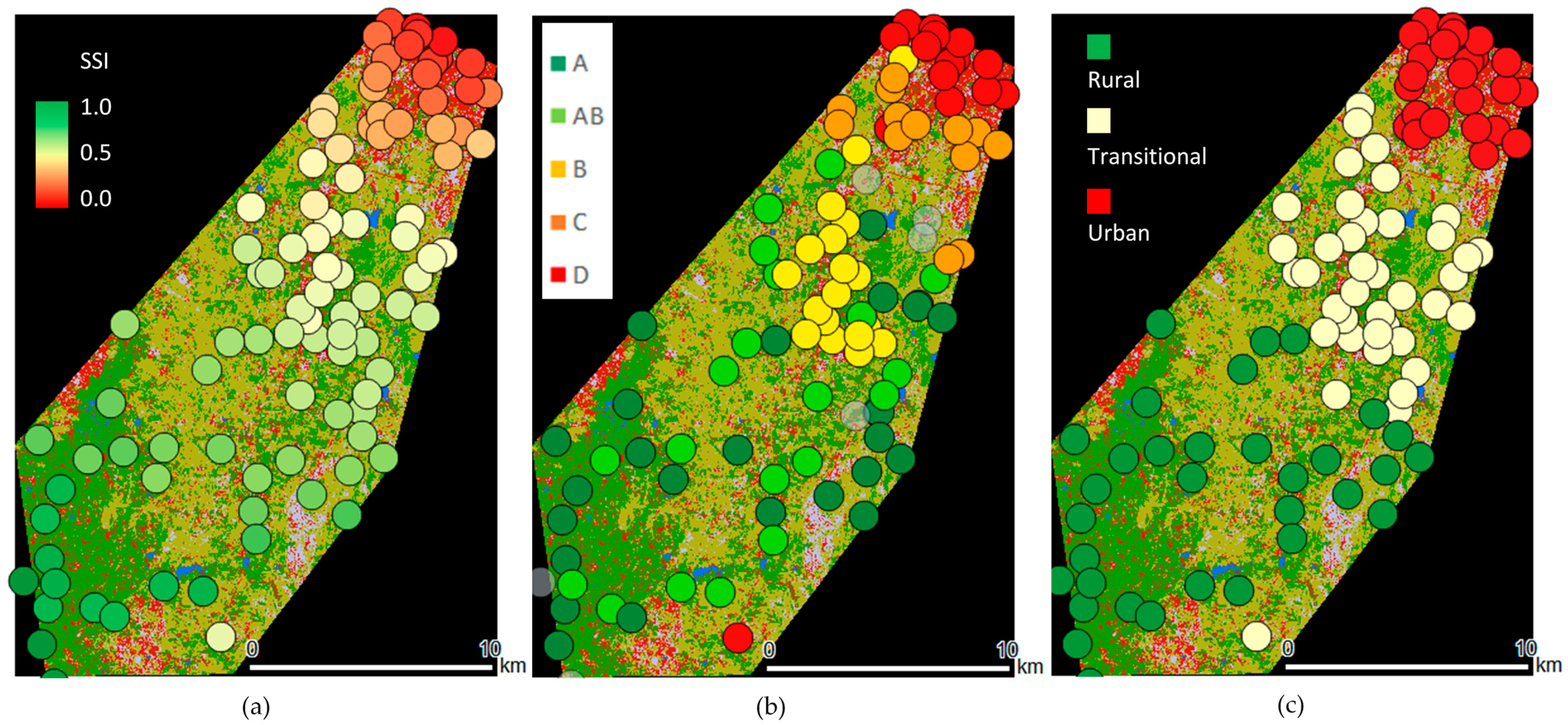
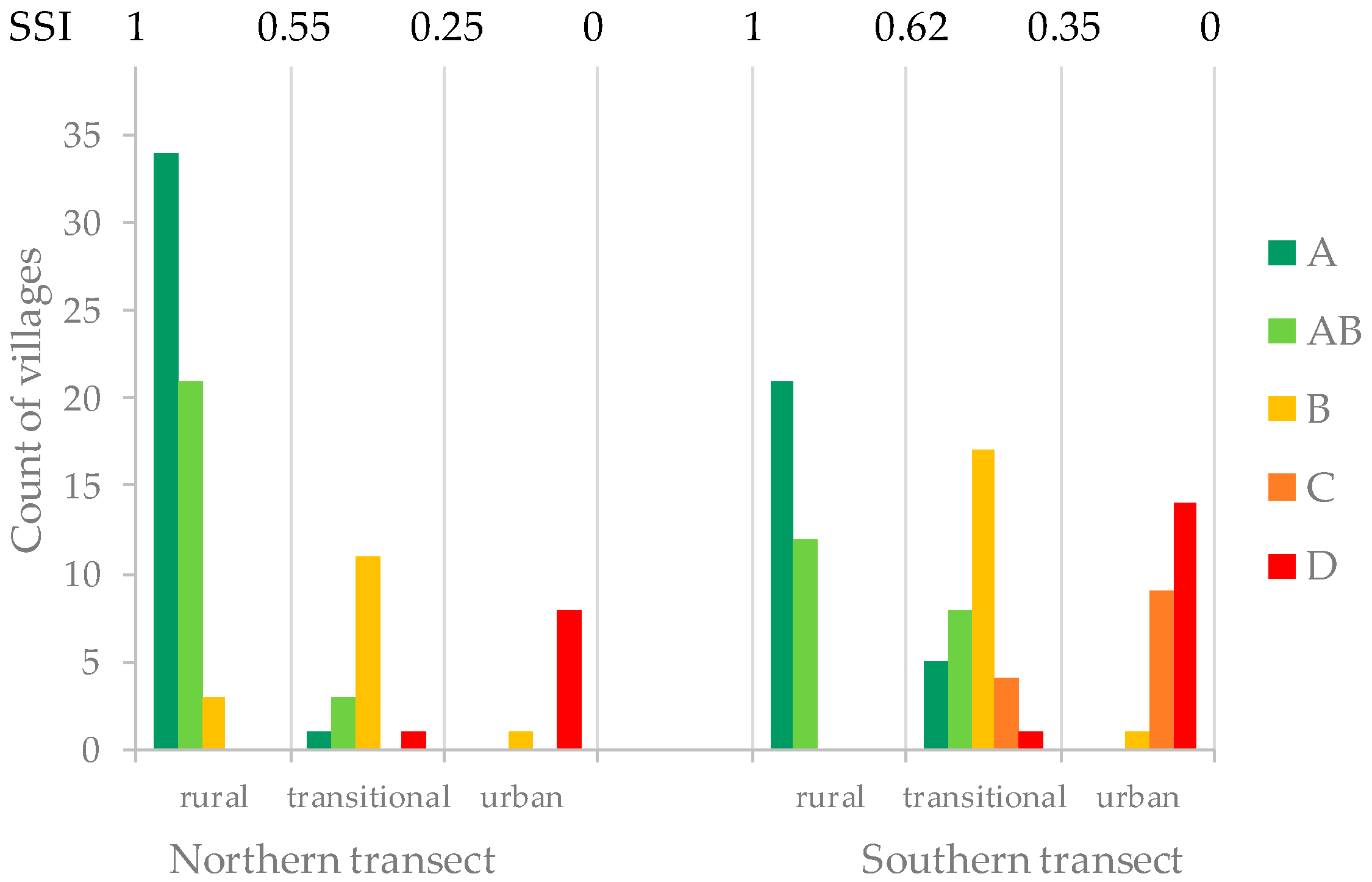
3.4. Survey Stratification Index, SSI
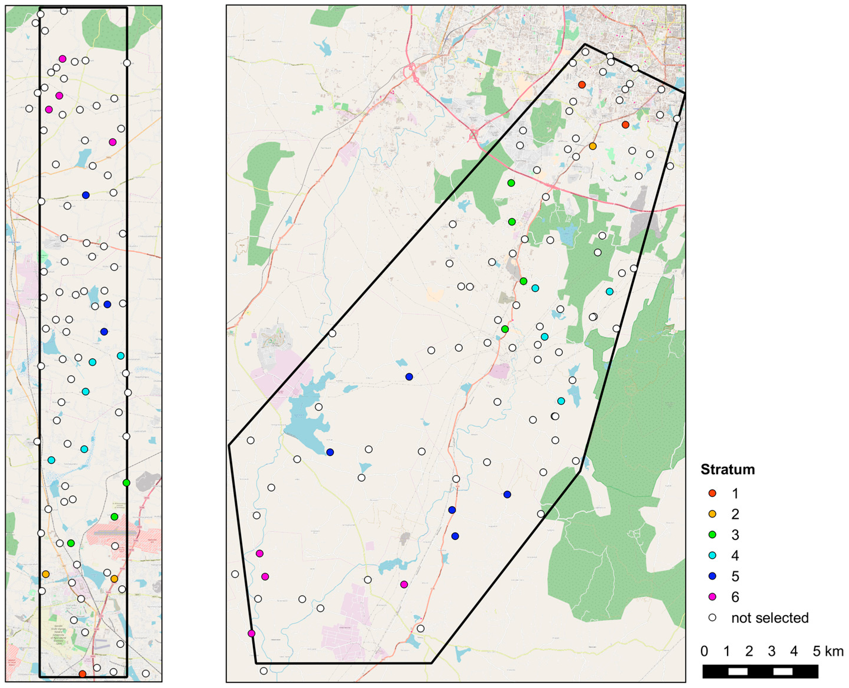
3.5. Stratification and Village Sampling
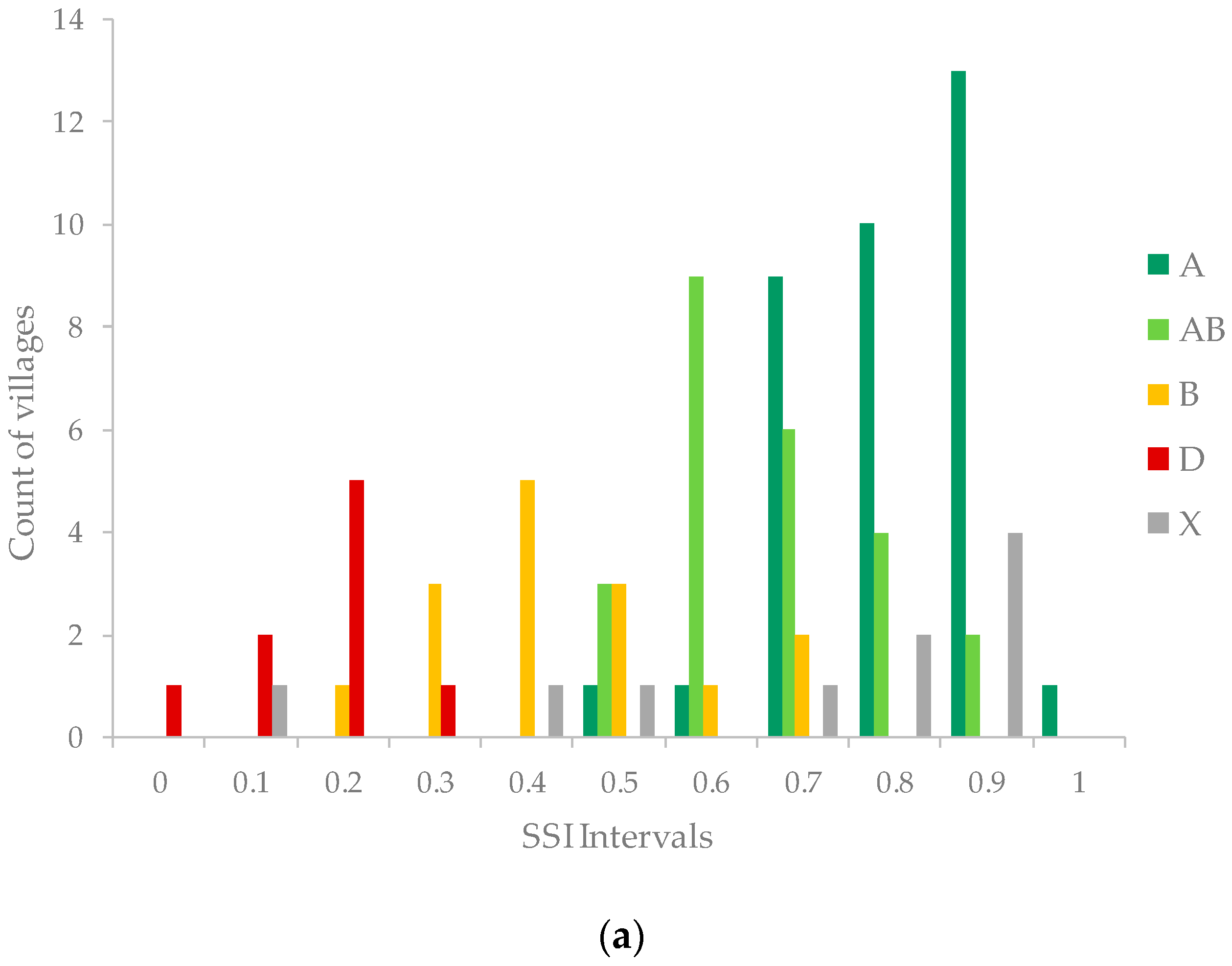
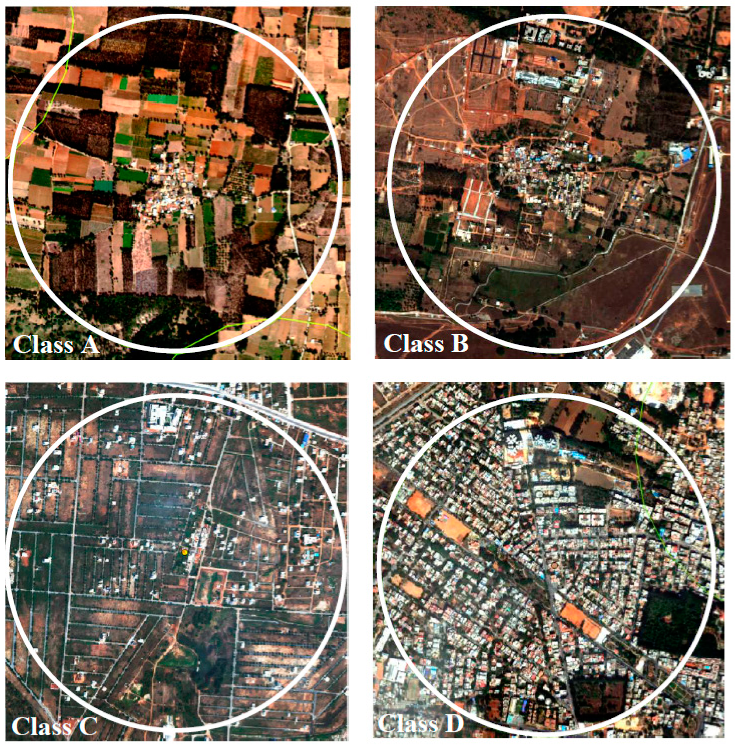
3.6. Landscape Structures and Village/Urban Morphologies
3.7. Delineating Structural Strata
4. Discussion
4.1. Survey Stratification Index, SSI
4.2. Village Morphologies
4.3. Other Approaches
5. Conclusions
Acknowledgments
Author Contributions
Conflicts of Interest
Appendix A. Alternative Approaches to Stratification and Random Selection of Settlements

| Transect | Strata Boundaries: Cum Root | Units in Each Stratum | Number of Units to Sample in Each Stratum | Strata Boundaries: LH | Units in Each Stratum | Number of Units to Sample in Each Stratum |
|---|---|---|---|---|---|---|
| North | <0.28 | 11 | 7 | <0.29 | 12 | 8 |
| 0.5 | 12 | 6 | 0.44 | 16 | 6 | |
| 0.64 | 16 | 6 | 0.62 | 13 | 5 | |
| 0.74 | 18 | 4 | 0.75 | 24 | 8 | |
| 0.86 | 18 | 4 | 0.85 | 16 | 3 | |
| >0.86 | 18 | 4 | >0.85 | 20 | 5 | |
| Total | 93 | 31 | 93 | 31 | ||
| South | <0.1963 | 14 | 5 | <0.1813 | 14 | 5 |
| 0.4363 | 14 | 8 | 0.3476 | 10 | 3 | |
| 0.5407 | 17 | 3 | 0.5375 | 21 | 8 | |
| 0.645 | 20 | 4 | 0.6505 | 20 | 4 | |
| 0.7598 | 17 | 4 | 0.7859 | 20 | 5 | |
| >0.7598 | 16 | 6 | >0.7859 | 13 | 5 | |
| Total | 98 | 30 | 98 | 30 |
| (a) Northern Transect | |||||
| Village Name | Distance (km) | Built-Up Area (%) | SSI | Stratum | Morphology Class |
| Addigandhalli | 21.56 | 18.34 | 0.516 | 4 | B |
| Adinarayanahosahalli | 33.09 | 6.63 | 0.764 | 5 | A |
| Agrahara | 22.42 | 4.31 | 0.578 | 4 | B |
| Alijenahalli | 38.41 | 3.04 | 0.861 | 6 | X |
| Allalasandra | 11.60 | 54.69 | 0.176 | 2 | D |
| Aluruguddanahalli | 32.53 | 6.42 | 0.756 | 5 | AB |
| Amruthahalli | 9.43 | 66.82 | 0.064 | 1 | D |
| Anantapura | 15.13 | 41.82 | 0.305 | 2 | B |
| Ardeshahalli | 26.97 | 12.09 | 0.641 | 4 | A |
| Atturu | 14.22 | 51.67 | 0.256 | 2 | D |
| Avalahalli | 17.49 | 35.48 | 0.377 | 3 | B |
| Ayyammanahalli | 46.59 | 9.12 | 0.942 | 6 | X |
| Bachchahalli | 30.25 | 15.44 | 0.683 | 5 | A |
| Bairadenahalli | 34.46 | 3.09 | 0.801 | 5 | A |
| Bannamangala | 31.11 | 9.75 | 0.720 | 5 | A |
| Basavanapur | 27.26 | 7.95 | 0.661 | 4 | A |
| Bettahalasur | 20.26 | 24.37 | 0.471 | 3 | AB |
| Bettanahalli | 25.37 | 7.34 | 0.628 | 4 | AB |
| Bhumenahalli | 44.22 | 9.77 | 0.908 | 6 | A |
| Bidikere | 40.45 | 6.21 | 0.875 | 6 | A |
| Byatarayapur | 9.57 | 77.42 | 0.060 | 1 | D |
| Chikka Bommasandra | 12.32 | 69.06 | 0.163 | 1 | D |
| Chikka Hegganahalli | 25.41 | 12.50 | 0.611 | 4 | AB |
| Chikka Muddenahalli | 47.16 | 6.23 | 0.964 | 6 | A |
| Chikkanahosahalli | 26.10 | 3.58 | 0.655 | 4 | A |
| Dasagondenahalli | 37.75 | 9.96 | 0.820 | 5 | A |
| Devarahalli | 28.81 | 7.19 | 0.691 | 5 | AB |
| Dinnuru | 30.84 | 6.49 | 0.729 | 5 | A |
| Gandarajapura | 39.66 | 10.98 | 0.842 | 6 | A |
| Gantiganahalli | 42.16 | 10.92 | 0.876 | 6 | A |
| Garighatta | 40.40 | 8.89 | 0.862 | 6 | A |
| Ghantiganahalli | 41.50 | 5.72 | 0.892 | 6 | AB |
| Guddadahalli | 32.33 | 18.12 | 0.704 | 5 | AB |
| Harohalli | 16.73 | 25.59 | 0.387 | 3 | B |
| Heggenahalli | 26.50 | 11.60 | 0.634 | 4 | AB |
| Hosuru | 27.48 | 15.10 | 0.638 | 4 | AB |
| Jakkuru | 11.07 | 46.38 | 0.171 | 2 | D |
| Jalige | 27.32 | 13.98 | 0.640 | 4 | AB |
| Jutnahalli | 28.81 | 5.33 | 0.698 | 5 | A |
| Kachahalli | 43.07 | 23.14 | 0.824 | 5 | A |
| Kamenahalli | 27.05 | 31.53 | 0.566 | 4 | AB |
| Kanchiganal | 39.74 | 11.08 | 0.842 | 6 | A |
| Kandasandra | 43.94 | 23.60 | 0.832 | 5 | X |
| Karanalu | 42.33 | 10.58 | 0.880 | 6 | AB |
| Kasavanahalli | 29.08 | 5.13 | 0.704 | 5 | A |
| Kenchenahalli | 15.48 | 36.81 | 0.327 | 2 | B |
| Kodihalli | 36.61 | 13.50 | 0.787 | 5 | AB |
| Konaghatta | 36.77 | 13.89 | 0.788 | 5 | A |
| Kudaragere | 22.91 | 8.63 | 0.575 | 4 | AB |
| Kuruvegere | 41.72 | 9.08 | 0.879 | 6 | A |
| Lakshmidevipur | 41.39 | 9.97 | 0.870 | 6 | X |
| Lingahiragollonalli | 30.47 | 6.84 | 0.721 | 5 | AB |
| Manchihalli | 15.04 | 13.27 | 0.370 | 3 | B |
| Maragondanahalli | 24.81 | 3.92 | 0.629 | 4 | AB |
| Maruthinagara | 14.19 | 61.08 | 0.228 | 2 | D |
| Moparahalli | 33.87 | 5.82 | 0.780 | 5 | A |
| Muddanahalli | 19.11 | 11.23 | 0.484 | 3 | AB |
| Nagadarsanahalli | 20.01 | 10.79 | 0.506 | 4 | A |
| Nagadenahalli | 33.69 | 15.38 | 0.736 | 5 | AB |
| Nagenahalli | 16.78 | 31.88 | 0.371 | 3 | B |
| Naraganahalli | 42.84 | 9.51 | 0.891 | 6 | A |
| Narasimhanahalli | 44.06 | 9.22 | 0.909 | 6 | A |
| Panditapur | 29.52 | 2.45 | 0.721 | 5 | A |
| Pedda tammanahalli | 46.02 | 6.94 | 0.946 | 6 | A |
| Puttanahalli | 14.47 | 60.22 | 0.237 | 2 | B |
| Raghunathpura | 34.18 | 24.88 | 0.700 | 5 | B |
| Rajaghatta | 38.28 | 16.05 | 0.799 | 5 | AB |
| Rajankunti | 22.71 | 21.28 | 0.530 | 4 | B |
| S(h)ivapura | 36.35 | 11.74 | 0.792 | 5 | A |
| Sadenahalli | 23.79 | 10.55 | 0.587 | 4 | AB |
| Sahakara Nagar | 9.21 | 84.96 | 0.032 | 1 | D |
| Satenahalli | 44.43 | 10.65 | 0.906 | 6 | A |
| Settahalasur | 16.59 | 33.86 | 0.362 | 3 | B |
| Singanayakanahalli | 18.79 | 30.30 | 0.421 | 3 | X |
| Sonnappanahalli | 36.02 | 8.26 | 0.802 | 5 | A |
| Sugatta | 18.26 | 9.16 | 0.468 | 3 | B |
| Sulakunte | 30.38 | 14.98 | 0.687 | 5 | AB |
| Sunaghatta | 30.91 | 7.56 | 0.726 | 5 | A |
| Sunnagaddahalli | 41.23 | 7.79 | 0.878 | 6 | A |
| Tankashahosahalli | 41.31 | 8.75 | 0.875 | 6 | A |
| Tarahunase | 22.08 | 13.68 | 0.542 | 4 | AB |
| Timmasandra_1 | 21.25 | 9.41 | 0.537 | 4 | X |
| Timmasandra_2 | 37.85 | 13.20 | 0.806 | 5 | X |
| Timmojamahalli | 42.56 | 7.06 | 0.900 | 6 | A |
| Tindlu_1 | 10.54 | 62.47 | 0.124 | 1 | X |
| Tindlu_2 | 28.13 | 8.94 | 0.673 | 5 | X |
| Tubagere | 43.68 | 25.68 | 0.817 | 5 | AB |
| Turuvanahalli | 47.04 | 9.75 | 0.944 | 6 | X |
| Varadanahalli | 30.86 | 15.78 | 0.691 | 5 | AB |
| Venkatala | 14.73 | 46.02 | 0.284 | 2 | B |
| Vobadenahalli | 32.83 | 10.85 | 0.743 | 5 | B |
| Yeddalahalli | 43.90 | 8.72 | 0.909 | 6 | A |
| Yelahanka | 13.52 | 64.86 | 0.203 | 2 | D |
| (b) Southern Transect | |||||
| Village Name | Distance (km) | Built-Up Area (%) | SSI | Stratum | Morphology Class |
| Agara | 18.90 | 24.49 | 0.493 | 3 | AB |
| Alhalli | 12.30 | 62.67 | 0.204 | 2 | C |
| Amruthnagar | 16.32 | 12.53 | 0.458 | 3 | X |
| Anjanpur | 13.35 | 50.24 | 0.268 | 2 | C |
| Arehalli | 9.27 | 60.27 | 0.075 | 1 | D |
| Badekatte | 20.96 | 9.97 | 0.591 | 4 | AB |
| Bairamangala | 31.37 | 23.24 | 0.744 | 5 | AB |
| Bannigeri | 30.28 | 15.42 | 0.762 | 5 | A |
| Betta halli kavadoddi | 28.50 | 11.97 | 0.744 | 5 | A |
| Bettarayanadoddi | 18.62 | 12.51 | 0.524 | 4 | AB |
| Bikaspur | 9.57 | 88.89 | 0.051 | 1 | D |
| Bylamaradadoddi | 19.86 | 4.20 | 0.582 | 4 | A |
| Chikkegaudanpalya | 13.71 | 12.51 | 0.370 | 3 | C |
| Choukahalli | 33.06 | 9.45 | 0.838 | 6 | A |
| Chuchgatta | 10.55 | 50.29 | 0.165 | 1 | D |
| Doddakabal | 40.07 | 14.05 | 0.927 | 6 | X |
| Doddakalsandra | 11.33 | 75.49 | 0.140 | 1 | D |
| Doddi | 17.31 | 5.57 | 0.506 | 4 | A |
| Gaddenchanpalya | 22.34 | 16.50 | 0.601 | 4 | B |
| Gadipalya | 24.57 | 18.13 | 0.642 | 4 | A |
| Ganiganpalya | 13.35 | 58.21 | 0.246 | 2 | D |
| Ganteganadoddi | 28.66 | 19.29 | 0.716 | 5 | AB |
| Gaudanapalya | 8.84 | 45.38 | 0.008 | 1 | D |
| Giriguddena Doddi | 27.09 | 11.85 | 0.718 | 5 | A |
| Gollahalli_1 | 37.11 | 0.80 | 0.948 | 6 | X |
| Gollahalli_2 | 29.25 | 18.01 | 0.732 | 5 | AB |
| Gopalpur | 22.83 | 12.04 | 0.628 | 4 | AB |
| Gulakamale | 21.37 | 25.44 | 0.547 | 4 | B |
| Guttepalya | 21.81 | 7.44 | 0.620 | 4 | B |
| Hanchipura | 28.94 | 11.70 | 0.754 | 5 | A |
| Harohalli | 35.38 | 67.05 | 0.529 | 4 | D |
| Hosahalli/Hasahalli | 12.76 | 50.43 | 0.250 | 2 | C |
| Hosur | 30.50 | 26.25 | 0.715 | 5 | A |
| Huchegaudanapalya | 24.57 | 18.49 | 0.641 | 4 | A |
| Hulagaudan Doddi | 36.47 | 22.48 | 0.828 | 5 | AB |
| Hulagaudanhalli | 36.43 | 23.80 | 0.820 | 5 | A |
| Hunchappanpalya | 11.85 | 35.54 | 0.249 | 2 | C |
| Isrolayout | 9.87 | 86.06 | 0.068 | 1 | D |
| Jettipalya | 28.20 | 12.86 | 0.735 | 5 | A |
| Kaddasikoppa | 37.46 | 24.46 | 0.832 | 5 | A |
| Kaggalhalli | 29.99 | 16.22 | 0.753 | 5 | A |
| Kaggalipura | 21.72 | 45.52 | 0.474 | 3 | B |
| Kanchigarapalya/Kunchigarapalaya | 21.01 | 15.73 | 0.573 | 4 | AB |
| Kanchugayyanadoddi | 17.39 | 14.03 | 0.485 | 3 | C |
| Karenahalli | 25.58 | 8.38 | 0.701 | 5 | AB |
| Kodipur | 9.99 | 44.79 | 0.143 | 1 | D |
| Kolaganhalli | 35.74 | 13.53 | 0.863 | 6 | A |
| Konankunte | 10.51 | 87.02 | 0.083 | 1 | D |
| Kulumepalya | 17.09 | 2.68 | 0.507 | 4 | X |
| Kumaraswamy Layout | 8.84 | 43.17 | 0.011 | 1 | D |
| Lakshmipur | 17.76 | 19.92 | 0.478 | 3 | B |
| Lingdiranahalli | 14.32 | 15.10 | 0.386 | 3 | C |
| Madigarapalya | 21.48 | 26.42 | 0.546 | 4 | B |
| Manjunath Ngara Chikkalsandra | 9.04 | 61.64 | 0.051 | 1 | D |
| Medmaranhalli | 34.34 | 13.65 | 0.840 | 6 | AB |
| Megal Gopahalli | 34.44 | 17.00 | 0.825 | 5 | A |
| Muddenhalli | 33.86 | 10.47 | 0.847 | 6 | AB |
| Mukkodalu | 25.59 | 15.87 | 0.672 | 5 | A |
| Munimarayyanadoddi | 17.70 | 12.52 | 0.498 | 3 | C |
| Muninagara | 26.25 | 8.39 | 0.715 | 5 | A |
| Nagegandanapalya | 14.82 | 20.71 | 0.390 | 3 | B |
| Nallammanadoddi | 19.98 | 9.86 | 0.567 | 4 | A |
| Narayanagurukul | 18.56 | 31.94 | 0.460 | 3 | B |
| Nayanakahalli | 24.07 | 8.57 | 0.668 | 5 | AB |
| Noukalapalya | 23.37 | 6.75 | 0.659 | 4 | A |
| Obichudahalli | 19.52 | 18.77 | 0.527 | 4 | B |
| Parasanapalya | 26.01 | 13.96 | 0.688 | 5 | A |
| Pattareddypalya | 22.59 | 21.28 | 0.589 | 4 | B |
| Perumanpalya/Peruvaiahnapalya | 31.02 | 12.02 | 0.790 | 5 | AB |
| Raghabanapalya | 12.67 | 13.68 | 0.326 | 2 | C |
| Rajanmadavu/Rachanamadu | 15.91 | 6.23 | 0.461 | 3 | AB |
| Ravugollu | 27.45 | 15.02 | 0.712 | 5 | AB |
| Saludoddi | 19.34 | 18.38 | 0.524 | 4 | B |
| Saluhanase | 20.55 | 28.80 | 0.517 | 4 | B |
| Santenahalli | 36.47 | 16.71 | 0.858 | 6 | AB |
| Shylendradoddi | 20.15 | 5.96 | 0.584 | 4 | A |
| Siddhanahallil | 38.92 | 6.83 | 0.947 | 6 | A |
| Silk farm | 15.67 | 12.01 | 0.439 | 3 | X |
| Somanahalli | 24.81 | 26.27 | 0.614 | 4 | AB |
| Subramanyapur | 10.56 | 60.96 | 0.147 | 1 | B |
| Sunkadakatte | 25.01 | 12.89 | 0.672 | 5 | X |
| Talghatpur | 13.48 | 58.05 | 0.250 | 2 | C |
| Taralu | 22.42 | 18.08 | 0.597 | 4 | B |
| Tataguni | 17.36 | 31.03 | 0.434 | 3 | B |
| Thattuguppe/Mariapura | 23.85 | 25.50 | 0.598 | 4 | AB |
| Timmaboyi doddi | 28.90 | 4.94 | 0.781 | 5 | A |
| Timmagaudanapalya/Banjarapalya | 20.39 | 5.14 | 0.593 | 4 | AB |
| Timmagaudandoddi | 31.97 | 20.63 | 0.767 | 5 | A |
| Timmayyanadoddi | 19.90 | 4.52 | 0.582 | 4 | A |
| Tipsandra | 12.34 | 44.34 | 0.250 | 2 | C |
| Turahalli | 11.40 | 52.67 | 0.197 | 2 | C |
| Udipalya | 19.45 | 33.25 | 0.476 | 3 | B |
| Uttarahalli | 9.60 | 80.75 | 0.069 | 1 | D |
| Uttarri | 20.78 | 13.50 | 0.575 | 4 | B |
| Vajarhalli | 12.74 | 61.85 | 0.219 | 2 | C |
| Vasantpur | 10.41 | 77.26 | 0.107 | 1 | D |
| Vasudevapur | 21.80 | 20.28 | 0.575 | 4 | B |
| Yalchenahalli | 9.40 | 76.43 | 0.065 | 1 | D |
| Number of Villages | Original Stratum Allocation | Allocation after Recalculation |
|---|---|---|
| 2 | 2 | 1 |
| 1 | 3 | 2 |
| 9 | 4 | 3 |
| 13 | 5 | 4 |
| 6 | 6 | 5 |
References
- Laquinta, D.; Drescher, A.W. Defining peri-urban: Understanding rural-urban linkages and their connection to institutional contexts. In Proceedings of the 10th World Congress of the International Rural Sociology Association, Rio De Janeiro, Brazil, 30 July–5 August 2000. [Google Scholar]
- Tacoli, C. The links between rural and urban development. Environ. Urban. 2003, 15, 3–12. [Google Scholar] [CrossRef]
- Pryor, R.J. Defining the rural-urban fringe. Soc. Forces 1968, 47, 202–215. [Google Scholar] [CrossRef]
- Simon, D. Urban environments: Issues on the peri-urban fringe. Ann. Rev. Environ. Resour. 2008, 33, 167–185. [Google Scholar] [CrossRef]
- Adell, G. Theories and models of the peri-urban interface: A changing conceptual landscape. In Strategic Environmental Planning and Management for the Peri-Urban Interface Research Project; Development Planning Unit: London, UK, 1999. [Google Scholar]
- DST (Desakota Study Team). Re-Imagining the Rural-Urban Continuum: Understanding the Role Ecosystem Services Play in the Livelihoods of the Poor in Desakota Regions Undergoing Rapid Change; Institute for Social and Environmental Transition-Nepal (ISET-N): Kathmandu, Nepal, 2008. Available online: http://r4d.dfid.gov.uk/PDF/Outputs/EnvRes/FinalReport_Desakota-PartI.pdf (accessed on 16 November 2017).
- Holling, C.S. Understanding the complexity of economic, ecological, and social systems. Ecosystems 2001, 4, 390–405. [Google Scholar] [CrossRef]
- Isserman, A.M. In the national interest: Defining rural and urban correctly in research and public policy. Int. Reg. Sci. Rev. 2005, 28, 465–499. [Google Scholar] [CrossRef]
- Waldorf, B.S. A Continuous multi-dimensional measure of rurality: Moving beyond threshold measures. In Proceedings of the Annual Meeting of the American Agricultural Economics Association, Long Island, CA, USA, 24–27 July 2006; Available online: http://purl.umn.edu/21383 (accessed on 16 November 2017).
- Inagami, S.; Gao, S.; Karimi, H.; Shendge, M.M.; Probst, J.C.; Stone, R.A. Adapting the Index of Relative Rurality (IRR) to estimate rurality at the ZIP code level: A rural classification system in health services research. J. Rural Health 2016, 32, 219–227. [Google Scholar] [CrossRef] [PubMed]
- Beynon, M.J.; Crawley, A.; Munday, M. Measuring and understanding the difference between urban and rural areas. Environ. Plan. B Plan. Des. 2015, 43, 1136–1154. [Google Scholar] [CrossRef]
- Schlesinger, J.; Drescher, A. Agriculture along the urban–rural continuum: A GIS-based analysis of spatiotemporal dynamics in two medium-sized African cities. Freibg. Geogr. Hefte 2013, 70. Available online: https://www.geographie.uni-freiburg.de/publikationen/abstracts/fgh70-en (accessed on 16 November 2017).
- Schlesinger, J. Using crowd-sourced data to quantify the complex urban fabric—OpenStreetMap and the Urban–Rural Index. In OpenStreetMap in GIScience, Lecture Notes in Geoinformation and Cartography; Jokar Arsanjani, J., Zipf, A., Mooney, P., Helbich, M., Eds.; Springer: Basel, Switzerland, 2015; pp. 295–315. [Google Scholar] [CrossRef]
- Giseke, U.; Kasper, C.; Mansour, M.; Moustanjidi, Y. E1 Connecting spheres: Urban agriculture as a multidimensional strategy: E1.4 Nine urban-rural morphologies. In Urban Agriculture for Growing City Regions. Connecting Urban-Rural Spheres in Casablanca; Giseke, U., Gerster-Bentaya, M., Helten, F., Kraume, M., Scherer, D., Spars, G., Amraoui, F., Adidi, A., Berdouz, S., Chlaida, M., et al., Eds.; Routledge: Abingdon, UK; New York, NY, USA, 2015; pp. 316–328. ISBN 978-0415825016. [Google Scholar]
- ISRO. Bhuvan: Indian Geo-Platform of ISRO. Available online: http://bhuvan.nrsc.gov.in/state/KA (accessed on 4 October 2016).
- Ravallion, M. Troubling tradeoffs in the Human Development Index. J. Dev. Econ. 2012, 99, 201–209. [Google Scholar] [CrossRef]
- Qiu, B.; Li, H.; Zhou, M.; Zhang, L. Vulnerability of ecosystem services provisioning to urbanization: A case of China. Ecol. Indic. 2015, 57, 505–513. [Google Scholar] [CrossRef]
- Huang, Y.; Li, F.; Bai, X.; Cui, S. Comparing vulnerability of coastal communities to land use change: Analytical framework and a case study in China. Environ. Sci. Policy 2012, 23, 133–143. [Google Scholar] [CrossRef]
- Dalenius, T.; Hodges, J.L., Jr. Minimum variance stratification. J. Am. Stat. Assoc. 1959, 54, 88–101. [Google Scholar] [CrossRef]
- Lavallee, P.; Hidiroglou, M.A. On the stratification of skewed populations. Surv. Methodol. 1988, 14, 33–43. [Google Scholar]
- Kozak, M. Optimal stratification using random search method in agricultural surveys. Stat. Transit. 2004, 6, 797–806. [Google Scholar]
- Er, S. Comparison of the efficiency of the various algorithms in stratified sampling when the initial solutions are determined with geometric method. Int. J. Stat. Appl. 2012, 2, 1–10. [Google Scholar] [CrossRef]
- WBGU–Wissenschaftlicher Beirat der Bundesregierung Globale Umweltveränderungen. Der Umzug der Menschheit: Die Transformative Kraft der Städte; WBGU: Berlin, Germany, 2016; Available online: http://www.wbgu.de/en/hg2016 (accessed on 16 November 2017).
- Salvati, L.; Sateriano, A.; Saradakou, E.; Grigoriadis, E. ‘Land-use mixité’: Evaluating urban hierarchy and the urban-to-rural gradient with an evenness-based approach. Ecol. Indic. 2016, 70, 35–42. [Google Scholar] [CrossRef]
- McGarigal, K.; Cushman, S.A.; Ene, E. FRAGSTATS V4: Spatial Pattern Analysis Program for Categorical and Continuous Maps, version 4; Computer Software Program Produced by the Authors at the University of Massachusetts; University of Massachusetts: Amherst, MA, USA, 2012; Available online: http://www.umass.edu/landeco/research/fragstats/fragstats.html (accessed on 16 November 2017).
- Peng, J.; Zhao, S.; Liu, Y.; Tian, L. Identifying the urban-rural fringe using wavelet transform and kernel density estimation: A case study in Beijing City, China. Environ. Model. Softw. 2016, 83, 286–302. [Google Scholar] [CrossRef]
- Bechtel, B.; Alexander, P.J.; Böhner, J.; Ching, J.; Conrad, O.; Feddema, J.; Mills, G.; See, L.; Stewart, I. Mapping local climate zones for a worldwide database of the form and function of cities. ISPRS Int. J. GeoInf. 2015, 4, 199–219. [Google Scholar] [CrossRef]
- Barve, N.; Kiran, M.C.; Vanaraj, G.; Aravind, N.A.; Rao, D.; Uma Shaanker, R.; Ganeshaiah, K.N.; Poulsen, J.G. Measuring and mapping threats to a wildlife sanctuary in Southern India. Conserv. Biol. 2005, 19, 122–130. [Google Scholar] [CrossRef]
- Stratification: Univariate Stratification of Survey Populations. Available online: https://cran.r-project.org/web/packages/stratification/index.html (accessed on 13 February 2017).


| N-Transect | S-Transect | ||
|---|---|---|---|
| 77.56452° E | 13.06168° N | 77.54041° E | 12.91496° N |
| 77.61002° E | 13.06139° N | 77.58161° E | 12.89523° N |
| 77.61119° E | 13.40723° N | 77.53850° E | 12.74446° N |
| 77.56321° E | 13.40669° N | 77.47762° E | 12.66770° N |
| 77.40577° E | 12.66762° N | ||
| 77.39460° E | 12.75478° N | ||
| Stratum | SSI Boundaries | N-Transect | S-Transect | ||
|---|---|---|---|---|---|
| Villages per Stratum | Villages per Stratum | ||||
| (Total) | (Randomly Selected) | (Total) | (Randomly Selected) | ||
| 1 (urban) | <0.167 | 5 | 2 | 14 | 4 |
| 2 | 0.333 | 9 | 3 | 10 | 3 |
| 3 | 0.5 | 9 | 3 | 13 | 4 |
| 4 | 0.667 | 18 | 6 | 26 | 8 |
| 5 | 0.833 | 30 | 10 | 23 | 7 |
| 6 (rural) | >0.833 | 22 | 7 | 12 | 4 |
| Total | 93 | 31 | 98 | 30 | |
© 2017 by the authors. Licensee MDPI, Basel, Switzerland. This article is an open access article distributed under the terms and conditions of the Creative Commons Attribution (CC BY) license (http://creativecommons.org/licenses/by/4.0/).
Share and Cite
Hoffmann, E.M.; Jose, M.; Nölke, N.; Möckel, T. Construction and Use of a Simple Index of Urbanisation in the Rural–Urban Interface of Bangalore, India. Sustainability 2017, 9, 2146. https://doi.org/10.3390/su9112146
Hoffmann EM, Jose M, Nölke N, Möckel T. Construction and Use of a Simple Index of Urbanisation in the Rural–Urban Interface of Bangalore, India. Sustainability. 2017; 9(11):2146. https://doi.org/10.3390/su9112146
Chicago/Turabian StyleHoffmann, Ellen M., Monish Jose, Nils Nölke, and Thomas Möckel. 2017. "Construction and Use of a Simple Index of Urbanisation in the Rural–Urban Interface of Bangalore, India" Sustainability 9, no. 11: 2146. https://doi.org/10.3390/su9112146
APA StyleHoffmann, E. M., Jose, M., Nölke, N., & Möckel, T. (2017). Construction and Use of a Simple Index of Urbanisation in the Rural–Urban Interface of Bangalore, India. Sustainability, 9(11), 2146. https://doi.org/10.3390/su9112146