Article

The Contribution of Physical Geographers to Sustainability Research

Department of Geography, Earth and Environmental Science, Okanagan College, Kelowna, BC V1Y 4X8, Canada
Sustainability 2017, 9(10), 1851; https://doi.org/10.3390/su9101851
Submission received: 2 July 2017 / Revised: 25 September 2017 / Accepted: 10 October 2017 / Published: 16 October 2017
(This article belongs to the Special Issue Physical Geography and Environmental Sustainability)

Abstract

:
A physical geographers’ scope of practice is not defined by any regulatory or academic organization, so perception of the potential contribution of physical geography to sustainability research has been nebulous or informal, at best. In order to understand what physical geographers can do to enhance sustainability, this paper describes a systematic review of peer-reviewed research on sustainability published in three physical geography journals. The results show that physical geographers are active in sustainability research in terms of a spatial perspective, an understanding of human interactions with the environment, and an ability to recognize, interpret, and project environmental change and its impacts. The depth of this understanding is facilitated by a physical geographers’ understanding of the natural world, process and system concepts, the ways that systems are linked and interact, and a willingness to deploy a wide range of methodologies to secure that knowledge. The expertise of physical geographers makes an important contribution to sustainability research and should be considered when multidisciplinary teams are assembled.

1. Introduction

There are many advantages to interdisciplinary, transdisciplinary, or multidisciplinary approaches to sustainability research [1]. However, separate and distinct academic disciplines also contribute to sustainability research, both in discrete projects and as part of multidisciplinary teams.
Assembling research teams is complex and requires an understanding of what the individual disciplines can contribute. In some cases this is fairly simple. Most project leaders have, or think they have, a good understanding of what geologists or biologists do, and if they do not, then environmental scientists, geologists, biologists, and other scientists have a scope of practice that is defined by learned societies and regulatory bodies. However, that is not the case with physical geographers, who form a large and important community, but are not represented by a single organization, nor regulatory body that spells out what exactly physical geographers do [2]. Insofar as The Stern Review posited that the physical geography of the planet is being altered by human activity [3], then it is reasonable to ask the extent to which physical geographers investigate the causes, impacts, and mitigation of those changes and consequently contribute to research on environmental sustainability [4,5].
Although it is recognized that physical geography cannot and should not work in isolation from other disciplines [6], physical geographers recognize the spatial and temporal complexities of the Earth in ways that sustainability science and Earth system science without physical geographers fail to consider [7,8]. The role of physical geography in sustainability has been identified as the establishment of baselines, the monitoring of change, and broad contextualization [8]. However, is it? If so, what do these statements mean in practice?
If geography is what geographers do, then an examination of what physical geographers do with respect to sustainability may assist an understanding of the role that they play in sustainability research. This paper documents a systematic examination of peer-reviewed physical geography research papers relating to sustainability. It attempts to answer the simple question: how does physical geography contribute to sustainability research?

2. Materials and Methods

The term sustainability was used in search engines on the journal home pages of Geografiska Annaler Series A, Physical Geography (Wiley, ISI 2015 impact factor = 1.609), Physical Geography (Taylor and Francis, ISI impact factor = 0.741), and Progress in Physical Geography (Sage, ISI impact factor = 3.375). Theses journals were chosen because each cover the entire field of physical geography and not just specializations, such as geomorphology or hydrology. All three journals draw international contributors, although each journal tends to have a substantial number of contributions from the region of their editorial offices. Geografiska Annaler, for instance, has editorial offices in Sweden, and many of the papers are from authors based in Europe. Similarly, Physical Geography is based out of the United States, and the majority of its papers are by United States.-based authors, although there are increasingly large numbers of papers from China. Progress in Physical Geography is a British publication, and has the most diverse international authorship. One recent issue, for example, contained papers with lead authors from India, Morocco, China (2), the United Kingdom, and the United States. The literature reviewed here is confined to English language publications, but is a broad-based selection of work by physical geographers from different countries on a range of topics relating to sustainability.
Only research papers published since 2007 (in the last 10 years) were included, and review papers were excluded. The total number of papers reviewed were four from Geografisker Annaler A, 33 from Physical Geography, and 56 from Progress in Physical Geography. The papers were read or scanned, and where there was no obvious connection of the research to sustainability, was eliminated from the analysis. No attempt was made to examine changes over the 10 year period.
The approach was to analyze and interpret the evidence in order to produce a synthesis of the literature that formed the evidence to answer the research question: how does physical geography contribute to sustainability research? Papers were examined in order to identify the sustainability connection. The topic of investigation, the objectives, and the methods and approaches were all examined. Papers were summarized and noted in a few sentences, and patterns and connections between papers noted. Sustainability has been described as a constructive ambiguity ([9] p. 3). The exact definition of sustainability used in the papers was not examined, and therefore the term sustainability is used in this paper sensu lato.
The organizing framework is a characterization of eight major themes of physical geography that have been identified from American, British, and Canadian textbook definitions of physical geography [2]. These themes are: a spatial perspective, the concept of a natural world, impacts on people, process and system concepts, anthropogenic impacts, environmental change, linkages between systems, and physical geography as a science. Papers were classified according to these themes, sometimes into multiple categories. There was no consideration of research funding sources, nor was there any judgment of research quality, completeness, or significance in terms of citations.
The method employed here does not claim to be a comprehensive survey of all sustainability- relevant work that has been undertaken by physical geographers, nor even the most important work. A lot more sustainability-related research by physical geographers is available in specialized journals, such as Water Resources Research, Geomorphology, etc. This was not included, since these journals also publish work by researchers in other disciplines. The disentanglement of work by geographers from the broader corpus of work by researchers in other disciplines would be a difficult and contentious process. The papers reviewed here are simply a sample of work that has been identified by both the editors and authors as worthy of being labeled physical geography and labeled by the journal indexing algorithm as sustainability related. The analysis is qualitative and inevitably colored by the author’s background and experience as a physical geographer.

3. Results

3.1. A Spatial Perspective

The spatial perspective is important in geography and separates it from other disciplines [10,11]. Aspects of the spatial perspective that are apparent in the literature reviewed here include investigations of the uniqueness of places, scale effects, and the use of remote sensing for spatial differentiation.

3.1.1. The Uniqueness of Places

Physical geographers know that landscapes are complex and that no single metric can adequately describe a landscape [12]. Everywhere is unique. Physical geographers do not just look for explanations of what is happening in the world, they recognize that explanations may be unique to a particular place. This means that approaches to sustainability may also be place-specific. Place-based approaches to the structure and dynamics of social-environmental systems in an ecosystem services paradigm have been recognized as potentially a key area where geography might make a distinctive contribution [13]. These authors emphasized the importance of different drivers of change in different places and their variable impact on ecological structures and functions. The need for fit-for-place design solutions to manage urban climates has been recognized [14] and geographers are not just concerned about global warming, they are concerned about the local effects of climate change, such as patterns of climate change across Wisconsin [15].
Physical geographers have recognized that river channel response to climate change vary from region to region [16] and on a broader scale the interactions of riparian vegetation and fluvial processes is seen as different in the tropics when compared with temperate regions [17]. The geomorphic impacts of the clearance of woody debris and riparian vegetation have been documented to be different in the New and Old Worlds [18].
On the basis that a recognition of local variations in precipitation can significantly impact reservoir placement and water resource management, a study of southeastern United States high-resolution radar precipitation estimates showed unique precipitation characteristics in different drainage basins, which is useful in distributed hydrologic models for water resources planning [19]. A GIS-based model, WetSpass, was used to estimate the water balance of a watershed in Ethiopia in order to determine sustainable levels of groundwater abstraction [20]. By using multiyear snowpack data from the Colarado Front Range and relating it to elevation, location, slope aspect, solar radiation, temperature, precipitation, and vegetation cover, it has also been possible to identify areas that are most vulnerable to climate change [21].
Although places are unique, they are also geographically interconnected in terms of environmental flows. In this context, moisture sources and wind direction are factors in site selection for cloud-seeding [22]. The idea of landscape connectivity is also important in biogeography, referring to the ability of species to move from one area to another, which is an important consideration in biodiversity conservation [23].

3.1.2. Geographic Scale

Geographers recognize that explanations of phenomena and criteria for sustainability are scale-dependent. In landscape ecology and ecological biogeography, for example, scale dependence manifests in terms of spatial resolution, geographic scale, and study area extent [24]. The importance of geographic scale, spatial resolution, extent of study area, and local variations is shown by research that conveys the value of plot size in the determination of optimal soil covers in order to reduce soil runoff and loss [25]. The ecosystem services concept has been seen as a way of linking together the ecosystems of Tanzania’s Eastern Arc Mountains and their impact on human welfare at multiple scales [26]. This multiscale perspective is particularly important when different stakeholders have different interests [13].
In some cases, it may simply be that relationships and explanations of phenomena apply best at a particular scale. One way that this has been investigated is by looking at the relationship between Moran’s I (an index of spatial autocorrelation) and the size of the window used to compute it. A study of the spatial arrangement of urban vegetation and its impact on surface temperature, for example, showed that a spatial resolution of 200 m best showed vegetation-temperature relationships. It was demonstrated that clusters of trees at this scale reduced surface temperature more effectively than dispersed trees at the local scale [27].

3.1.3. Use of Remote Sensing to Detect Spatial Differences

Physical geographers have long held a fascination with remote sensing, which has many applications in biogeography and related fields. Field-work is still very important in physical geography, but the focus is usually on one area. Remote sensing gives a spatial perspective. Remote sensing is used in landscape ecology to analyze spatial patterns and relate them to ecological processes [28] as well as to assess forest ecosystem health and sustainability [29]. Remote sensing-derived estimates of biodiversity based on productivity, disturbance, topography, and land cover have been proposed [30] along with studies of animal and plant invasions [31] and soil organic carbon [32]. Remote sensing can be used to assess ecosystem services using a broad range of measured or modeled groups of variables, such as plant functional traits, soil characteristics, biogeochemical cycling, and water availability [33].
Remote sensing has extended the range of field surveys in the Canadian boreal forest, with the collection of data on seasonal greenness, wetlands, terrain ruggedness, and seasonality defined by spring snow cover, annual minimum cover, autumn snow cover, and annual productivity. The use of these variables has enabled the authors to identify clusters that could be explained in terms of latitudinal variation [34]. Moreover, the monitoring of pioneer vegetation by remote sensing has been assisted by spectrometric measurements in the laboratory [35].

3.2. Anthropogenic Impacts

Although physical geographers have traditionally focused on the natural world, anthropogenic impacts on the landscape is a major theme in contemporary physical geography [2]. Interaction between humans and the landscape is argued to go beyond traditional cause-and-effect investigations and is evolving into studies that investigate the interactions and feedbacks between people and landscapes [36]. There are many studies of the human-landscape system [36] in the literature, with many focused on urban environments, agriculture, impacts on biodiversity, and changes in land cover and land use.

3.2.1. Urban Environments

Urban environments are becoming a focus of attention for physical geographers, particularly with regard to urban hydrology and climates. It has been argued that the amount of paving is a good proxy measure for the human footprint on the environment [37]. However, a study shows that urban paving is not always as impermeable as commonly assumed. Infiltration changes over time as surfaces degrade and are renewed and this variability that is associated with the age of the paved surface may be important in urban hydrology models, especially those with a high spatial resolution. This is important, as there has been a recent move away from trying to remove surface water as quickly and efficiently as possible [38]. An ecohydrological approach to urban stormwater management has been proposed as a means of mitigating a flood hazard, improving water quality, and providing enhanced social amenity [39]. Hydrographs may also be influenced by urban development and climate change, although the combined effects may either be amplified or ameliorated, depending on local circumstances [40].
Physical geographers are also interested in urban climates. Urban heat islands that are caused by the radiative properties of construction materials, reduced evaporative cooling, and aerodynamic changes are detrimental to sustainability in terms of their impacts on human health and the provision of water and energy resources. Physical geographers have shown interest in the potential mitigation of urban climate effects by appropriate urban design and planning in different environments [27,41]. Urban climates also have a broader climate context in terms of the urban carbon flux and its impact on the global carbon cycle [41].
The need for appropriate urban sites has also drawn interest in China, where rapid industrialization has stimulated urbanization and created urban sprawl around existing centers. However, new planned cities are also being constructed. In order to determine the optimal physical location of urbanization in a part of China, a GIS-based back-propagation (BP) neural network model was used to evaluate data on the geomorphology, slope, soil, and groundwater conditions and anticipated geologic hazards in order to identify an optimal location for urbanization [42].

3.2.2. Agriculture

Modern agriculture is widely believed to be detrimental to the landscape, an assertion that is supported by evidence that pre-Columbian land use did not produce the high levels of soil erosion and floodplain sedimentation that was associated with the European colonization of North America [43]. However, much of the work by physical geographers on agricultural impacts has been executed outside Europe and North America. The effectiveness of soil and water conservation systems in Ethiopia has been assessed [44,45]. In China, there have been investigations of the impacts of several soil and water conservation schemes on the Loess Plateau [46] and research on the rehabilitation of degraded red soils [47]. Gully erosion in the Black Soil region of Northeast China has been largely due to human activity, and poses a threat to food security [48]. Soil erosion on the Loess Plateau of China was assessed by 137Cs that was released into the environment as radioactive fall-out from mid-20th century nuclear tests. It has been shown that the amount of 137Cs decreases with the amount of soil erosion. Investigations have shown that land use is one of the main controls on soil erosion, with an increase in soil erosion from mature forest to grass to young forest to orchard to agricultural terraces [49].
The sustainability of wetlands in Zimbabwe used for cultivation has been assessed with a scoring system based on the extent, intensity, and magnitude of different types of land use. Fieldwork was used to determine the geomorphic setting, water source, pattern of water-flow through the wetland, soil texture, and wetness, and local farmers were interviewed. Land cover was mapped using satellite imagery and local climate and slope data were collected from public sources. The results showed that the cultivation techniques used disrupted wetland hydrology, and were therefore unsustainable [50]. In Iran, human impacts on soil erosion have been shown to not just depend on the type and level of human activity, but also on physico-chemical properties of the soil. By relating erosion to land use and geology, it was possible to map the erodibility of soils [51].
Physical geography has also provided overviews of controversial genetically modified GMO crop technologies [52]. These authors documented yield increases due to improvements in weed and insect control, which have also carried over to adjacent conventional crops. The reduction in pesticide application has reduced groundwater pollution and carbon footprints. However, there is also some evidence of the growing tolerance of weeds and insects to GMO crop varieties.

3.2.3. Biodiversity

Biodiversity challenges in sustainability manifest themselves in terms of introductions, extinctions, and land-cover changes. Microbes have been studied as microbial pollution, with much of the research undertaken by physical geographers in response to government policy objectives in North America and Europe [53]. On a broader front, it is clear that the depletion and extinction of species is closely related to human activity, even when the species is not directly exploited by people. Although habitat loss and degradation has been less documented than over-exploitation, it is clear that land-cover change is an important stressor on biodiversity [54]. Agricultural intensification combined with climate change impacts land cover, which in turn impacts habitats, particularly for migratory species. In China, another investigation showed that large-scale land-use policy combined with climate change is having an impact on the overall vegetation [55].
Novel approaches have been developed to monitor biodiversity, such as terrestrial laser scanning of lichen-covered surfaces, a process that allows for repeat surveys in order to determine the impacts of people on lichens in the Shenandoah National Park, Virginia. The long-term monitoring of rock outcrops in areas that are closed to hikers and climbers can then be compared with climbing routes and hiking trails to determine the advisability of opening or closing public access in areas of the park [56]. Human impacts on middle and late Holocene vegetation on the Qinghai–Tibetan Plateau have been assessed based on pollen analysis of lake sediment core and archaeological evidence [57].
A feasibility study of multifunctional artificial reefs for small islands is an example of a proactive approach to conservation [58].

3.2.4. Land Cover, Land-Use Change, and Other Impacts

Other human impacts on sustainability include a wide range of miscellaneous effects. Landsat imagery was used to assess land-cover change from 1990 to 2015 in a national park in Bhutan in order to help forest ecosystem management [59]. Similarly, the impacts of forest clearance and subsequent sequences of land-use change have impacted the lower parts of an urban catchment in New Zealand much more than the upper parts of the catchment. This is because urbanization impacts occurred primarily in the lower parts of the catchment and the cumulative effects of multiple disturbances in the upper part of the catchment are still being felt in the lower part of the catchment [60].
The decomposition of a time series of declining karst spring discharge in China showed that, from 1957 to 1978, declines in stream-flow were due to climate change, but that since then the changes in discharge have been due to both climate change and human activity. With human activity, 34–52% of the declines were due to groundwater abstraction and 48–62% due to other activities, such as coal mining, deforestation, and dam construction [61]. In order to determine the level of human disturbance in karst systems, a GIS model was developed that assessed factors related to cave disturbance [62].
The biogeomorphological impacts of constructing a canal across a desert wash were determined by field sedimentology and GIS change-detection applied to aerial photographs in order to assess riparian vegetation [63]. The impacts of light pollution, human-caused fire, and land-surface temperature change in protected areas can be measured by satellite remote sensing [64]. The various impacts of United Kingdom peatland management practices have been investigated and seen as being timely in terms of the European Union Water Framework Directive’s implementation [65]. Using imagery and maps, it has been possible to show that sand and gravel mining in floodplains creates pits that impact river hydraulics during flood events and change the planform [66].

3.3. Impacts on People

Physical geographers are not just interested in the ways that people impact the environment. The study also shows that physical geographers are interested in the impacts of the environment on people. The relationship between husbandry activities, grassland health, and commodity prices on the Inner Mongolian steppes, for example, has been investigated [67]. A variation of this approach looks at landscape services capability, in which flow and demand is a conception of sustainability that relates to the potential of a landscape to produce materials, energy, information, conditions, and effectiveness valued by people [68]. They have argued that this paradigm could potentially be used for landscape sustainability assessment.
Most studies of the impact of the natural environment on people is in the context of natural resources (particularly water resources) and natural hazards. Some of this work has focused on climate change, but there have been more studies of the ways that people respond to the challenges of their environment and how the environment reacts.

3.3.1. Water Resources

Changes in local water resources and consumption due to climate change and changing land use have been investigated in the Indianapolis area [69] and Phoenix, Arizona [70]. The impacts of climate change on snowpack distribution as a water resource in the Colorado Front Range has also been investigated [21]. Interestingly, a study of the relationship between weather and urban water consumption in Seoul, South Korea, showed an expected relationship between maximum daily temperature and water consumption, but also produced a surprising conclusion that wind speed is also an important control because of its impact on evaporative cooling [71].

3.3.2. Natural Hazards

Physical geographers interested in sustainability have investigated coastal, landslide, and desertification hazards. The risks associated with living in coastal areas have been determined on the basis of sea-level rise, wave height, tidal range, shoreline evolution, elevation, geomorphology, and distance to an urban area [72]. Various strategies for the mitigation of debris flows in China, such as check dams, drainage channels, and the planting of vegetation, have been investigated [73]. In a review of landslide-risk reduction measures in the tropics, it was found that a lot of research focused on the biophysical factors that controlled landslides, with much less work on the quantitative assessment of landslide impacts. The point is made that the responsibilities of scientists include the need to effectively communicate their work to policymakers and to populations that may be impacted by landslides. This requires an understanding of social, political, cultural, and economic aspects [74] that are not always considered, except where work is multidisciplinary. Desertification hazards have been investigated by GIS modeling of desertification in Iran, for example, to create a zoning map that can be used for planning [75].

3.4. Linkages between Systems

Physical geographers are not just interested in systems, they take a big picture view of the world, and seek to understand connections and interactions between systems. These include linkages between human and natural systems, some of which have already been described so far in this article.
Human-environment linkages are sometimes framed in the context of ecosystem services. Physical geographers can make a significant contribution to the research and policy questions posed by the notion of ecosystem services by helping to characterize the structure and dynamics of social-ecological systems [13]. As an example, a review of ecosystem services associated with urban water identifies the types of social, ecological, and physical science studies that need to be applied, as for instance to a restored urban river [76].
The analysis of environmental flows is another approach that has been used in research on the sustainability of rivers [77]. In this case, it was suggested that there was a need to examine both biophysical and socioeconomic needs in order to identify appropriate flow. Environmental flows have been also used as a framework for the investigation of riparian-zone sustainability, with an examination of the connections between vegetation, geomorphology, and hydrology [17]. More broadly, a proposal to set sustainability standards based on economic and moral values is also a call for more research on ecosystem functions and processes on a broad front [78].
Linkages between systems that do not significantly involve human activity are also investigated by physical geographers and have implications for sustainability. Physical geographers, for example, have extended ecological studies of upland swamps of the plateau areas of eastern Australia by an investigation of relationships between the geomorphology, sedimentology, and hydrology of the area, helping to understand the wetland response to precipitation [79].
Another approach has been to look at linkages in the context of the critical zone of Earth’s surface, which includes organisms, rock, soil, water, and air [80]. Disturbance of this critical zone forms a solid starting point for understanding the feedbacks that operate within this complex geomorphic-pedogenic-biotic system. Thus, there are biotic-geomorphic, biotic-pedogenic, pedogenic-geomorphic, and biotic-pedogenic–geomorphic feedback processes. High rates of soil erosion and degradation can sometimes be explained by the interaction of biophysical factors, such as soil properties, climatic characteristics, topography, and vegetation, without any need to reference anthropogenic processes [81]. The impacts of soil erosion on weed seedbanks, with consequent impacts on biodiversity, have also been discussed [82].
Physical geographers are well-equipped to deal with these flows, system interactions, and feedbacks, an understanding of which is particularly important in the mitigation of climate change and the restoration of degraded or severely damaged ecosystems.

3.5. Environmental Change

A study of biodiversity and the extinction of common and widespread species has been argued to connect the past, present, and future [54] and past, current, and future climates have been the focus for much physical geographers’ work on environmental change. The analysis of changes in the landscape at different spatial scales is complex and may require a wide range of techniques, including remote sensing, field mapping, historical analysis, and interviews with local stakeholders, as was performed in a study of changes in the Miombo woodland, Tanzania [83]. Physical geographers combine an understanding of processes, spatial variations, and time to produce a deep understanding of the cascades of processes, events, feedbacks, and consequences that defy simple cause-and-effects reasoning.

3.5.1. Current Change

Physical geographers are making important contributions to understanding the ways that climate change, along with other factors, impacts environment and resources. Physical geographers have been particularly adept at unraveling the complexities of some of these interactions. One study in China, for example, showed that the lower limits of sub-alpine forest are advancing faster than the upper treeline, resulting in a contraction of the forest. This was because age structure is important in the altitudinal response of trees to climate change [84]. In another example of the complexities of environmental change, an examination of the impacts of both climate and land-use change on hydrology found that total runoff was more susceptible to climate change than to land use, but that surface runoff was more susceptible to land-use change [85]. The complexity of these relationships is echoed in another study [86], which showed that there is evidence of climate change controls on groundwater levels in the United Kingdom, but that water abstraction and land-cover changes also contribute to declines in groundwater levels. The complexity of environmental change attribution is also illustrated by investigations of rockfalls that threaten the sustainability of high-mountain infrastructure. Although there have been changes in surface ice and permafrost in the French Alps, in one case study it has been suggested that the construction of a rock refuge probably contributed to the problem [87].
As indicated in previous sections, the detection of change over time with remote sensing archives has also been a focus of research in physical geography. The availability of multiple images over several decades requires not just a comparison of spectral values, but of changes in patterns, as suggested by trends in patch density, the number and size of patches, fractal dimension, edge density, mean proximity index, and interspersion/juxtaposition. This approach has been successfully undertaken in a study of mountain pine beetle impacts in British Columbia, Canada [88].
Physical geographers have also been involved in studies of changing carbon budgets. The impacts of soil organic matter on carbon budgets and global climate change have been described [32]. Investigations of carbon sequestration in dead trees at the treeline potentially complicates understanding the impacts of poleward treeline migration on carbon sequestration [89].

3.5.2. Past Change

As big-picture people, physical geographers are concerned with the both the spatial and temporal context for processes. From a Quaternary perspective, an examination of the last glacial-interglacial transition and the Little Ice Age is argued to provide evidence of the likely impacts on biodiversity, ecosystem services, agriculture, and water resources over coming decades, which is therefore relevant to sustainability [90]. The management of climate risk has been significantly aided by historical data rescue, climate reconstruction, and the compilation of climate databases [91]. Using dendrochronology, it has been possible to extend historical climate records in the northern Tibetan Plateau since 1780, which provided a long-term context for rapid recent increases in temperature in the region [92].

3.5.3. Future Change

Future environmental change is clearly relevant to sustainability. Some studies of future change impacts are relatively straightforward, such as, for example, the possible effects of future climate change on the decay of building stones [93] or on river channel morphology [16]. However, complexities soon become apparent with respect to water resources, especially in places such as Las Vegas. By the use of hydrological modeling, population projection, land-use change modeling, and analysis of water management policies, it was possible to determine some water options for Las Vegas under various climate, population, land-use, and water management scenarios for 2050 [94].

3.6. Process and System Concepts

The investigation of systems and processes in physical geography has long been a mainstay of the discipline. However, in sustainability applications, these processes have often been subsidiary. However, there are exceptions. In terms of systems, an understanding of the impacts of wild-land fire on erosion, flash floods, and debris flows is important for land management agencies and especially risk management [95]. Systems are often understood by physical geographers through models and different models of soil erodibility have been evaluated [96].
Processes have also been examined. Trying to understand the importance of a keystone species, such as the cactus Carnegiea giganta, requires an understanding of reproductive processes. The cactus is long-lived and its reproduction depends on flowers and fruits on branches that can take a long time to develop. In extreme cases, the branching process does not commence until old-age and mortality is also an issue. Understanding the reproductive process and environmental controls on the development of branches enables an understanding of the vulnerability of the species [97]. Understanding processes is also important in understanding the decay of building stones [98]. Perhaps, most importantly, based on a knowledge of processes in physical geography, it is clear that some human impacts can be mitigated, e.g., by urban design that encourages and enables stormwater harvesting and reuse, together with temperature reduction by evapotranspiration from tree-planting [14].

3.7. The Concept of a Natural World

The concept of a natural world is fundamental to the idea of sustainability insofar as, hypothetically at least, it provides a baseline for judgment of anthropogenic impacts. However, those types of baseline studies appear to be rarely executed as standalone projects by physical geographers. However, some research studies of the natural world justify the work in terms of potential sustainability applications. A study of wetlands in arid environments, for example, identified an understanding of the factors that produce wetlands, geomorphic, and sedimentary processes as critical for sustainable management [99], and an assessment of the contribution of glacial meltwater runoff to total watershed discharge was undertaken in the context of climate change risk assessment and sustainable water management in glacierized watersheds [100]. Remote sensing of the ocean has been rationalized as critical for understanding and predicting climate change, energy exploration, and sustainable food harvesting and production [101]; and the importance of spatial variability of precipitation in the lower Mississippi, for example, can be rationalized on the basis of agriculture in the region [102]. In general, much of the work on the natural world appears to be rationalized in terms of human utility of the environment rather than baseline monitoring.

3.8. Physical Geography as a Science

Most physical geography textbooks describe the scientific method as usually invoking some combination of inductive and deductive approaches [2]. However, traditional science is increasingly under attack for being out-of-touch with the world. The point has been made, for example, that most papers on landslide disaster risk reduction in the tropics are published in natural science rather than social science journals [74]. However, social scientists have reached out to physical geographers [103] and many physical geographers have responded, albeit in different ways.
In practice, it is clear that a considerable amount of work on sustainability by physical geographers relies on some combination of methods used in the physical sciences and those used in the social sciences. A study of the evolution of an urban catchment in New Zealand, for example, used fieldwork, sediment analysis, and historical documents, such as maps, settler notes, and anecdotal records [60]. This blend of methods is perhaps an inevitable consequence of the nature of sustainability as a human construct; and as one paper has put it in the context of ecosystem services, it is driven as much by political agendas as by scientific ones [103].
At a more profound level, there has been interest in applications of critical theory to physical geography. One example is the documentation of the development of coyote-proof fencing in the early 20th century and its reinterpretation from a critical physical geography perspective. The author [104] concluded that the experiments undertaken at the time were put forward as serious science, but in reality the methodology was weak and the criteria for success were more economic than scientific. The author goes on to argue that critical physical geography reveals the economic, political, and institutional background behind the science. Critical physical geography is also used in ethnogeomorphology, which is an approach that questions the whole idea of landscapes as passive objects that need to be explained [105]. Ethnogeomorphology is seen as a way of connecting the human use of the environment with a landscape that incorporates multiple perspectives of place. From a sustainability perspective, such an approach allows for voices that would otherwise be marginalized to be incorporated into decision-making.
Critical theory has been advocated as an approach to the study of climate, where applied climatologists are criticized for appearing to avoid difficult questions about the relevance of their research to social structure [106]. The authors proceed to identify five themes that link the study of atmospheric process to social-environmental outcomes viz. climate change adaptation, commercialization of climate science, climate services for development, sustainable architecture, and atmospheric justice. They explored the traditional viewpoint of positivistic climate science applied to society, attempted to move beyond that position to recognize the values and bias behind traditional applied climatology, and move towards an approach based on the idea of applying atmospheric research to matters of real human concern.
Other social science approaches have also been used. Participatory action research is seen as a way of moving research forward by collaboration and the co-production of research [107]. In contrast to shallow participatory approaches, the authors encourage the use of a deep approach, where participants participate in the formulation of research questions and processes. Citing an example based on an investigation of farm slurry pollution conducted with the United Kingdom Rivers Trust, they were able to produce a map that showed the location of farms that were at a higher risk of producing slurry that might contaminate rivers. This was suggested by community members and was something that university-based researchers had not considered. Barriers certainly need to be overcome in research of this type. It has been argued that the Linnaean nomenclatural system creates unequal power relations inherent in the integration of local knowledge into scientific discourse [108].
Different types of approaches have not been without their critics: for many, transdisciplinary research still appears to be on the edge of scientific respectability [76]. The economic valuation of ecosystems services has also been critiqued [109]. They argued that such an approach is inherently biased and that the commodification of ecosystem services will lead to environmental degradation.
In contrast to the criticisms of traditional scientific approaches, there has been a call for a scientific basis for decision-making for urban planning and land management for Hangzhou, and scientific support for improving urban living environments [42]. In addition, Chen et al. [46] advocated for a scientific and detailed land-use plan to improve soil and water conservation on the Loess Plateau in China. However, they too emphasized the importance of public participation and education in the implementation, if not the development, of such schemes.

4. Discussion

The approach used in this study has identified large amounts of sustainability-related research that has been undertaken by physical geographers. The fact that just three journals were searched represents a limitation of the study and as such it cannot claim to be a comprehensive survey of all work undertaken by physical geographers. The fact that all of the research was in English-language publications is also a limitation. However, the findings do point to a wide range of approaches and subjects of investigation used by physical geographers in research that is sustainability related.
All of the papers were identified as falling into one or more of the eight themes recognized in a previous study of textbook definitions of physical geography definitions. The analytical framework, therefore appears to be successful. Each of the eight themes of physical geography is represented in the analysis, and this provides a framework for the identification of approaches taken by physical geographers in sustainability research (Figure 1). It is clear that physical geographers do much more than establish baselines, monitor change, and contextualize, as a previous study has postulated [8].
The results show that physical geographers are active in sustainability research in terms of a spatial perspective of the Earth, an understanding of human interactions with the environment, and an ability to recognize, interpret, and project environmental change and its impacts. The depth of this understanding is facilitated by physical geographers’ understanding of the natural world, process and system concepts, the ways that systems interact, and a willingness to deploy a wide range of methodologies to secure that knowledge. Although the role of physical geography in sustainability research primarily involves environmental sustainability, much of the work on hazards, water resources, and urban and agricultural environments touches on cultural, social, and economic well-being. Methodological innovations, such as applications of critical theory and participatory action research, also involve cultural and social sustainability.
The spatial perspective is critical. A use of remote sensing and spatial analysis is informed by an understanding of scale issues and spatial contextualization. Physical geographers’ understanding of human interactions with the environment involves both human-induced change and environmental impacts on people. The separation of these two aspects of human interaction is sometimes difficult. Urban and agricultural environments have substantially modified Earth’s natural environment and are also the home of people and, consequently, it is difficult to separate cause-and-effect in these contexts.
Physical geographers also contribute to the monitoring of environmental change. Sometimes, investigations are in response to government policy (e.g., [53,65]), but most studies are ad-hoc approaches that explore the mechanisms of change and the complex ways that systems interact and respond. Physical geographers are adept at the attribution of change in dynamic and complex environmental systems that include both natural and anthropogenic processes. They understand the importance of stationarity as a statistical assumption and can provide the context that takes snapshots in time and place and makes them meaningful. Physical geographers combine an understanding of current change and system process to project change into the future under various scenarios. A focus on impacts of future change on people makes studies of this kind of value for sustainability.
Although physical geography is sometimes informally defined as the study of the natural world, and field studies of the natural world have historically formed a major part of the subject, it appears from the papers examined in Section 3.7 of this paper that physical geographers undertake relatively little original research on the natural world explicitly from a sustainability perspective. Despite the assertion that physical geographers support sustainability by the establishment of baselines [8], this study provides little direct evidence that this is the case. However, the large body of work on human impacts implicitly relies on physical geographers’ profound understanding of the ways that the Earth works without humans. This depth of knowledge is an important component of the physical geographers’ toolbox.
The physical geographers’ toolbox is large. As a community, they deploy a wide range of intellectual and technical skills, although no individual researcher will be competent in everything. The toolbox is primarily based on field skills, laboratory analysis, spatial and aspatial modeling, remote sensing, spatial analysis, and knowledge of Earth’s systems and the ways that they vary over space and time.
The findings published here may have limited applicability. At best, it is a snapshot of papers published in broad-based physical geography journals over a 10-year period. Many physical geographers publish their work in specialized journals [110] and/or in languages other than English [111]. It would be worthwhile to examine more specialized work by geographers published in journals such as Water Resources Research, Earth Surface Processes, and Geomorphology in order to further test the findings. The challenge would be to identify those researchers whose background is primarily physical geography. It would also be worthwhile to investigate the broader applicability of the findings by focussing on a specific country, such as China [112], and also to investigate changes in approach over time.

5. Conclusions

(1)
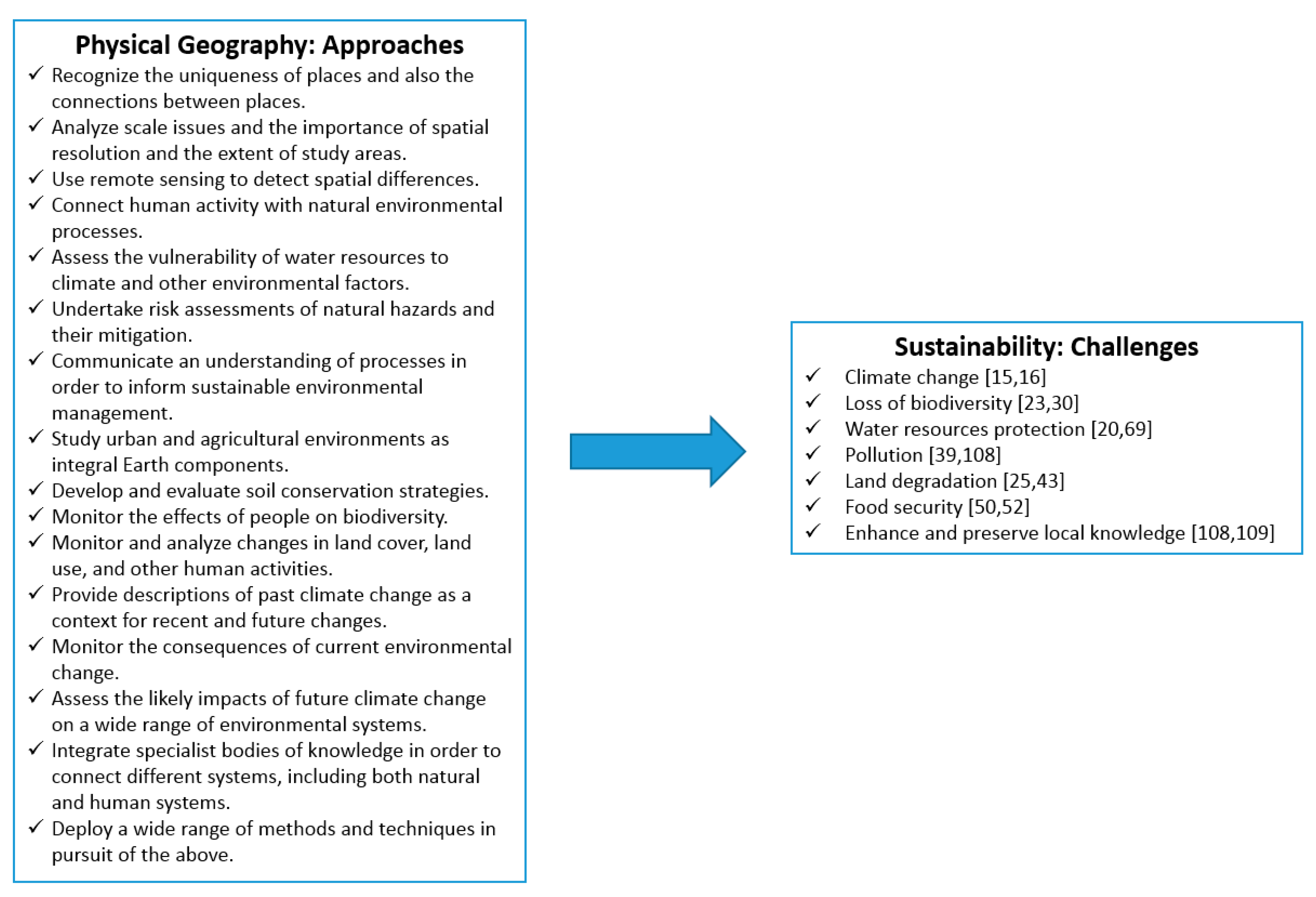
The study shows that physical geographers are actively involved in sustainability research challenges relating to climate change, loss of biodiversity, water resources, pollution, land degradation, food security, and the enhancement and preservation of local knowledge.
(2)
Physical geographers have an ability to think spatially and produce integrated and detailed explanations of diverse phenomena over a range of timescales. They have an ability to generate answers to very complex questions, which is an important component of the quest for survival of Earth’s populations.
(3)
Physical geographers recognize the uniqueness of places and the importance of geographic scale in research. They are experts in the use of remote sensing and in field work, not just in natural environments, but also in urban and agricultural environments. They are interested in water resource sustainability and in the effects of natural hazards on people. Physical geographers are not just interested in systems and processes, they are also interested in the interaction of different types of natural systems and human interactions with these systems. They study environmental change at multiple time-scales in the Quaternary. Physical geographers usually work within a framework of scientific analysis, although some researchers challenge the assumptions and limitations of science.
(4)
Physical geographers cannot claim a monopoly on environmental sustainability expertise. However, any multidisciplinary research team that does not include physical geographers faces the risk of potentially producing shallow, overgeneralized, simplistic explanations of what they are trying to study. In these ways, physical geographers add value to sustainability research projects.

Acknowledgements

My thanks to Mary Thornbush and the anonymous reviewers for constructive comments and encouragement. I also thank Marie Molloy for her ongoing support.

Conflicts of Interest

The author declares no conflict of interest.

References

  1. Bailey, J.; Van Ardelan, M.; Hernández, K.L.; González, H.E.; Iriarte, J.L.; Olsen, L.M.; Salgado, H.; Tiller, R. Interdisciplinarity as an Emergent Property: The Research Project CINTERA and the Study of Marine Eutrophication. Sustainability 2015, 7, 9118–9139. [Google Scholar] [CrossRef] [Green Version]
  2. Day, T. Core themes in textbook definitions of physical geography. Can. Geogr. 2017, 61, 28–40. [Google Scholar] [CrossRef]
  3. Stern, V. The Stern Review; Government Equalities Office, Home Office: London, UK, 2010.
  4. Ashmore, P.; Dodson, B. Urbanizing physical geography. Can. Geogr. 2017, 61, 102–106. [Google Scholar] [CrossRef]
  5. Thornbush, M. Geography, urban geomorphology and sustainability. Area 2015, 47, 350–353. [Google Scholar] [CrossRef]
  6. Rasmussen, K.; Arler, F. Interdisciplinarity at the human-environment interface. Geogr. Tidsskr.-Dan. J. Geogr. 2010, 110, 37–45. [Google Scholar] [CrossRef]
  7. Clifford, N.J. Globalization: A physical geography perspective. Prog. Phys. Geogr. 2009, 33, 5–16. [Google Scholar] [CrossRef]
  8. Inkpen, R. Development: Sustainability and physical geography. Key Concepts Geogr. 2009, 378–391. [Google Scholar]
  9. Dale, A. On the Edge; UBC Press: Vancouver, BC, Canada, 2001. [Google Scholar]
  10. Christopherson, R.W.; Birkeland, G. Geosystems: An Introduction to Physical Geography; Pearson Education Limited: London, UK, 2015. [Google Scholar]
  11. Petersen, J.F.; Sack, D.; Gabler, R.E. Physical Geography; Cengage Learn: Boston, MA, USA, 2017. [Google Scholar]
  12. Wang, Q.; George, P. Malanson, G.P. Patterns of correlation among landscape metrics. Phys. Geogr. 2007, 28, 170–182. [Google Scholar] [CrossRef]
  13. Potschin, M.B.; Haines-Young, R.H. Ecosystem services: Exploring a geographical perspective. Prog. Phys. Geogr. 2011, 35, 575–594. [Google Scholar] [CrossRef]
  14. Coutts, A.M.; Tapper, N.J.; Beringer, J.; Loughnan, M.; Demuzere, M. Watering our cities: The capacity for water sensitive urban design to support urban cooling and improve human thermal comfort in the Australian context. Prog. Phys. Geogr. 2013, 37, 2–28. [Google Scholar] [CrossRef]
  15. Kucharik, C.J.; Serbin, S.P.; Vavrus, S.; Hopkins, E.J.; Motew, M.M. Patterns of climate change across Wisconsin from 1950 to 2006. Phys. Geogr. 2010, 31, 1–28. [Google Scholar] [CrossRef]
  16. Lotsari, E.; Thorndycraft, V.; Alho, P. Prospects and challenges of simulating river channel response to future climate change. Prog. Phys. Geogr. 2015, 39, 483–513. [Google Scholar] [CrossRef]
  17. Moggridge, H.L.; Higgitt, D.L. Interactions between riparian vegetation and fluvial processes within tropical Southeast Asia: Synthesis and future directions for research. Prog. Phys. Geogr. 2014, 38, 716–733. [Google Scholar] [CrossRef]
  18. Brierley, G.J.; Brooks, A.P.; Fryirs, K.; Taylor, M.P. Did humid-temperate rivers in the Old and New Worlds respond differently to clearance of riparian vegetation and removal of woody debris? Prog. Phys. Geogr. 2005, 29, 27–49. [Google Scholar] [CrossRef]
  19. Dyer, J. Evaluation of surface and radar-estimated precipitation data sources over the Lower Mississippi River alluvial plain. Phys. Geogr. 2009, 30, 430–452. [Google Scholar] [CrossRef]
  20. Gebremeskel, G.; Kebede, A. Spatial estimation of long-term seasonal and annual groundwater resources: Application of WetSpass model in the Werii watershed of the Tekeze River Basin, Ethiopia. Phys. Geogr. 2017, 1–22. [Google Scholar] [CrossRef]
  21. Richer, E.E.; Kampf, S.K.; Fassnacht, S.R.; Moore, C.C. Spatiotemporal index for analyzing controls on snow climatology: Application in the Colorado Front Range. Phys. Geogr. 2013, 34, 85–107. [Google Scholar]
  22. Omidvar, K.; Ahmadabad, M.K.; Moghbel, M. A synoptic analysis of site selection for cloud seeding in central Iran. Phys. Geogr. 2013, 34, 188–210. [Google Scholar]
  23. Correa Ayram, C.A.; Mendoza, M.E.; Etter, A.; Pérez Salicrup, D.R. Habitat connectivity in biodiversity conservation: A review of recent studies and applications. Prog. Phys. Geogr. 2016, 40, 7–37. [Google Scholar] [CrossRef]
  24. Kent, M. Biogeography and landscape ecology. Prog. Phys. Geogr. 2007, 31, 345–355. [Google Scholar] [CrossRef]
  25. Smets, T.; Poesen, J.; Bochet, E. Impact of plot length on the effectiveness of different soil-surface covers in reducing runoff and soil loss by water. Prog. Phys. Geogr. 2008, 32, 654–677. [Google Scholar] [CrossRef]
  26. Fisher, B.; Turner, R.K.; Burgess, N.D.; Swetnam, R.D.; Green, J.; Green, R.E.; Kajembe, G.; Kulindwa, K.; Lewis, S.L.; Marchant, R.; et al. Measuring, modeling and mapping ecosystem services in the Eastern Arc Mountains of Tanzania. Prog. Phys. Geogr. 2011, 35, 595–611. [Google Scholar] [CrossRef] [Green Version]
  27. Fan, C.; Myint, S.W.; Zheng, B. Measuring the spatial arrangement of urban vegetation and its impacts on seasonal surface temperatures. Prog. Phys. Geogr. 2015, 39, 199–219. [Google Scholar] [CrossRef]
  28. Newton, A.C.; Hill, R.A.; Echeverría, C.; Golicher, D.; Rey Benayas, J.M.; Cayuela, L.; Hinsley, S.A. Remote sensing and the future of landscape ecology. Prog. Phys. Geogr. 2009, 33, 528–546. [Google Scholar] [CrossRef]
  29. Falkowski, M.J.; Wulder, M.A.; White, J.C.; Gillis, M.D. Supporting large-area, sample-based forest inventories with very high spatial resolution satellite imagery. Prog. Phys. Geogr. 2009, 33, 403–423. [Google Scholar] [CrossRef]
  30. Duro, D.C.; Coops, N.C.; Wulder, M.A.; Han, T. Development of a large area biodiversity monitoring system driven by remote sensing. Prog. Phys. Geogr. 2007, 31, 235–260. [Google Scholar] [CrossRef]
  31. Rocchini, D.; Andreo, V.; Förster, M.; Garzon-Lopez, C.X.; Gutierrez, A.P.; Gillespie, T.W.; Hauffe, H.C.; He, K.S.; Kleinschmit, B.; Mairota, P.; et al. Potential of remote sensing to predict species invasions: A modelling perspective. Prog. Phys. Geogr. 2015, 39, 283–309. [Google Scholar] [CrossRef]
  32. Yadav, V.; Malanson, G. Progress in soil organic matter research: Litter decomposition, modelling, monitoring and sequestration. Prog. Phys. Geogr. 2007, 31, 131–154. [Google Scholar] [CrossRef]
  33. Andrew, M.E.; Wulder, M.A.; Nelson, T.A. Potential contributions of remote sensing to ecosystem service assessments. Prog. Phys. Geogr. 2014, 38, 328–353. [Google Scholar] [CrossRef]
  34. Powers, R.P.; Coops, N.C.; Morgan, J.L.; Wulder, M.A.; Nelson, T.A.; Drever, C.R.; Cumming, S.G. A remote sensing approach to biodiversity assessment and regionalization of the Canadian boreal forest. Prog. Phys. Geogr. 2013, 37, 36–62. [Google Scholar] [CrossRef]
  35. Götze, C.; Gerstmann, H.; Gläßer, C.; Jung, A. An approach for the classification of pioneer vegetation based on species-specific phenological patterns using laboratory spectrometric measurements. Phys. Geogr. 2017, 1–17. [Google Scholar] [CrossRef]
  36. Harden, C.P. The human-landscape system: Challenges for geomorphologists. Phys. Geogr. 2014, 35, 76–89. [Google Scholar] [CrossRef]
  37. Sutton, P.C.; Anderson, S.J.; Elvidge, C.D.; Tuttle, B.T.; Ghosh, T. Paving the planet: Impervious surface as proxy measure of the human ecological footprint. Prog. Phys. Geogr. 2009, 33, 510–527. [Google Scholar] [CrossRef]
  38. Redfern, T.W.; Macdonald, N.; Kjeldsen, T.R.; Miller, J.D.; Reynard, N. Current understanding of hydrological processes on common urban surfaces. Prog. Phys. Geogr. 2016, 40, 699–713. [Google Scholar] [CrossRef] [Green Version]
  39. Fletcher, T.D.; Vietz, G.; Walsh, C.J. Protection of stream ecosystems from urban stormwater runoff: The multiple benefits of an ecohydrological approach. Prog. Phys. Geogr. 2014, 38, 543–555. [Google Scholar] [CrossRef]
  40. Praskievicz, S.; Chang, H. A review of hydrological modelling of basin-scale climate change and urban development impacts. Prog. Phys. Geogr. 2009, 33, 650–671. [Google Scholar] [CrossRef]
  41. Mills, G. Micro-and mesoscale climatology. Prog. Phys. Geogr. 2008, 32, 293–301. [Google Scholar] [CrossRef]
  42. Xu, K.; Kong, C.; Li, J.; Zhang, L. Geo-Environmental suitability evaluation of land for urban construction based on a back-propagation neural network and GIS: A case study of Hangzhou. Phys. Geogr. 2012, 33, 457–472. [Google Scholar] [CrossRef]
  43. James, L.A. Contrasting geomorphic impacts of pre-and post-Columbian land-use changes in Anglo America. Phys. Geogr. 2011, 32, 399–422. [Google Scholar] [CrossRef]
  44. Haregeweyn, N.; Tsunekawa, A.; Nyssen, J.; Poesen, J.; Tsubo, M.; Meshesha, D.T.; Schütt, B.; Adgo, E.; Tegegne, F. Soil erosion and conservation in Ethiopia: A review. Prog. Phys. Geogr. 2015, 39, 750–774. [Google Scholar] [CrossRef]
  45. Taye, G.; Poesen, J.; Wesemael, B.V.; Vanmaercke, M.; Teka, D.; Deckers, J.; Goosse, T.; Maetens, W.; Nyssen, J.; Hallet, V.; et al. Effects of land use, slope gradient, and soil and water conservation structures on runoff and soil loss in semi-arid Northern Ethiopia. Phys. Geogr. 2013, 34, 236–259. [Google Scholar] [Green Version]
  46. Chen, L.; Wei, W.; Fu, B.; Lü, Y. Soil and water conservation on the Loess Plateau in China: Review and perspective. Prog. Phys. Geogr. 2007, 31, 389–403. [Google Scholar] [CrossRef]
  47. Lü, Y.; Chen, L.; Fu, B. Land-cover effects on red soil rehabilitation in China: A meta-analysis. Prog. Phys. Geogr. 2008, 32, 491–502. [Google Scholar]
  48. Zhang, T.; Liu, G.; Duan, X.; Wilson, G.V. Spatial distribution and morphologic characteristics of gullies in the Black Soil Region of Northeast China: Hebei watershed. Phys. Geogr. 2016, 37, 228–250. [Google Scholar] [CrossRef]
  49. Fu, B.; Wang, Y.-F.; Lu, Y.-H.; He, C.-S.; Chen, L.-D.; Song, C.-J. The effects of land-use combinations on soil erosion: A case study in the Loess Plateau of China. Prog. Phys. Geogr. 2009, 33, 793–804. [Google Scholar] [CrossRef]
  50. Marambanyika, T.; Beckedahl, H.; Ngetar, N.S.; Dube, T. Assessing the environmental sustainability of cultivation systems in wetlands using the WET-health framework in Zimbabwe. Phys. Geogr. 2017, 38, 62–82. [Google Scholar] [CrossRef]
  51. Nosrati, K.; Feiznia, S.; Van Den Eeckhaut, M.; Duiker, S.W. Assessment of soil erodibility in Taleghan Drainage Basin, Iran, using multivariate statistics. Phys. Geogr. 2011, 32, 78–96. [Google Scholar] [CrossRef]
  52. Mannion, A.M.; Morse, S. Biotechnology in agriculture: Agronomic and environmental considerations and reflections based on 15 years of GM crops. Prog. Phys. Geogr. 2012, 36, 747–763. [Google Scholar] [CrossRef] [Green Version]
  53. Kay, D.; Edwards, A.C.; Ferrier, R.C.; Francis, C.; Kay, C.; Rushby, L.; Watkins, J.; McDonald, A.T.; Wyer, M.; Crowther, J.; et al. Catchment microbial dynamics: The emergence of a research agenda. Prog. Phys. Geogr. 2007, 31, 59–76. [Google Scholar] [CrossRef]
  54. Gaston, K.J.; Fuller, R.A. Biodiversity and extinction: Losing the common and the widespread. Prog. Phys. Geogr. 2007, 31, 213–225. [Google Scholar] [CrossRef]
  55. Ostwald, M.; Simelton, E.; Chen, D.; Liu, A. Relation between vegetation changes, climate variables and land-use policy in Shaanxi province, China. Geogr. Ann. A 2007, 89, 223–236. [Google Scholar] [CrossRef]
  56. Wasklewicz, T.; Staley, D.; Mihir, M.; Seruntine, L. Virtual recording of lichen species: Integrating terrestrial laser scanning and GIS techniques. Phys. Geogr. 2007, 28, 183–192. [Google Scholar] [CrossRef]
  57. Huang, X.; Liu, S.; Dong, G.; Qiang, M.; Bai, Z.; Zhao, Y.; Chen, F. Early human impacts on vegetation on the northeastern Qinghai-Tibetan Plateau during the middle to late Holocene. Prog. Phys. Geogr. 2017, 41, 0309133317703035. [Google Scholar] [CrossRef]
  58. Ng, K.; Thomas, T.; Phillips, M.R.; Calado, H.; Borges, P.; Veloso-Gomes, F. Multifunctional artificial reefs for small islands: An evaluation of amenity and opportunity for Sao Miguel Island, the Azores. Prog. Phys. Geogr. 2015, 39, 220–257. [Google Scholar] [CrossRef]
  59. Sharma, K.; Robeson, S.M.; Thapa, P.; Saikia, A. Land-use/land-cover change and forest fragmentation in the Jigme Dorji National Park, Bhutan. Phys. Geogr. 2017, 38, 18–35. [Google Scholar] [CrossRef]
  60. Gregory, C.E.; Reid, H.E.; Brierley, G.J. River recovery in an urban catchment: Twin streams catchment, Auckland, New Zealand. Phys. Geogr. 29, 222–246. [CrossRef]
  61. Hao, Y.; Wang, Y.; Zhu, Y.; Lin, Y.; Wen, J.-C.; Yeh, J.-C.J. Response of karst springs to climate change and anthropogenic activities: The Niangziguan Springs, China. Prog. Phys. Geogr. 2009, 33, 634–649. [Google Scholar] [CrossRef]
  62. Van Aken, M.; Harley, G.L.; Dickens, J.F.; Polk, J.S.; North, L.A. A GIS-based modeling approach to predicting cave disturbance in karst landscapes: A case study from west-central Florida. Phys. Geogr. 2014, 35, 123–133. [Google Scholar] [CrossRef]
  63. Hamdan, A. Biogeomorphological effects of the Central Arizona Project (CAP) canal on a small ephemeral wash near Apache Junction, Arizona. Phys. Geogr. 2012, 33, 183–204. [Google Scholar] [CrossRef]
  64. Gillespie, T.W.; Willis, K.S.; Ostermann-Kelm, S. Spaceborne remote sensing of the world’s protected areas. Prog. Phys. Geogr. 2015, 39, 388–404. [Google Scholar] [CrossRef]
  65. Ramchunder, S.J.; Brown, L.E.; Holden, J. Environmental effects of drainage, drain-blocking and prescribed vegetation burning in UK upland peatlands. Prog. Phys. Geogr. 2009, 33, 49–79. [Google Scholar] [CrossRef]
  66. Mossa, J.; Marks, S.R. Pit avulsions and planform change on a mined river floodplain: Tangipahoa River, Louisiana. Phys. Geogr. 2011, 32, 512–532. [Google Scholar] [CrossRef]
  67. Emerson, C.; Veeck, G.; Li, Z.; Yu, F.; Zhang, H. Biophysical and agroeconomic influences on pasture quality in Da’erhanmaoming’an Union Banner, Inner Mongolian Autonomous Region, China. Phys. Geogr. 2010, 31, 552–581. [Google Scholar] [CrossRef]
  68. Fang, X.; Zhao, W.; Fu, B.; Ding, J. Landscape service capability, landscape service flow and landscape service demand: A new framework for landscape services and its use for landscape sustainability assessment. Prog. Phys. Geogr. 2015, 39, 817–836. [Google Scholar] [CrossRef]
  69. Davis Todd, C.E.; Goss, A.M.; Tripathy, D.; Harbor, J.M. The effects of landscape transformation in a changing climate on local water resources. Phys. Geogr. 2007, 28, 21–36. [Google Scholar] [CrossRef]
  70. Balling, R.C.; Cubaque, H.C. Estimating future residential water consumption in Phoenix, Arizona based on simulated changes in climate. Phys. Geogr. 2009, 30, 308–323. [Google Scholar] [CrossRef]
  71. Praskievicz, S.; Chang, H. Identifying the relationships between urban water consumption and weather variables in Seoul, Korea. Phys. Geogr. 2009, 30, 324–337. [Google Scholar] [CrossRef]
  72. Tahri, M.; Maanan, M.; Maanan, M.; Bouksim, H.; Hakdaoui, M. Using Fuzzy Analytic Hierarchy Process multi-criteria and automatic computation to analyse coastal vulnerability. Prog. Phys. Geogr. 2017, 41, 0309133317695158. [Google Scholar] [CrossRef]
  73. Xiong, M.; Meng, X.; Wang, S.; Guo, P.; Li, Y.; Chen, G.; Qing, F.; Cui, Z.; Zhao, Y. Effectiveness of debris flow mitigation strategies in mountainous regions. Prog. Phys. Geogr. 2016, 40, 768–793. [Google Scholar] [CrossRef]
  74. Maes, J.; Kervyn, M.; de Hontheim, A.; Dewitte, O.; Jacobs, L.; Mertens, K.; Vanmaercke, M.; Vranken, L.; Poesen, J. Landslide risk reduction measures: A review of practices and challenges for the tropics. Prog. Phys. Geogr. 2017, 41, 191–221. [Google Scholar] [CrossRef]
  75. Negaresh, H.; Rakhshani, Z.; Firoozi, F.; Alinia, H. Desertification assessment using the analytic hierarchy process and GIS in southeast Iran. Geogr. Ann. A 2016, 98, 1–14. [Google Scholar] [CrossRef]
  76. Lundy, L.; Wade, R. Integrating sciences to sustain urban ecosystem services. Prog. Phys. Geogr. 2011, 35, 653–669. [Google Scholar] [CrossRef]
  77. O’Keeffe, J. Sustaining river ecosystems: Balancing use and protection. Prog. Phys. Geogr. 2009, 33, 339–357. [Google Scholar] [CrossRef]
  78. Ekins, P. Environmental sustainability: From environmental valuation to the sustainability gap. Prog. Phys. Geogr. 2011, 35, 629–651. [Google Scholar] [CrossRef]
  79. Fryirs, K.; Gough, J.; Hose, G.C. The geomorphic character and hydrological function of an upland swamp, Budderoo Plateau, Southern Highlands, NSW, Australia. Phys. Geogr. 2014, 35, 313–334. [Google Scholar] [CrossRef]
  80. Raab, T.; Krümmelbein, J.; Schneider, A.; Gerwin, W.; Maurer, T.; Naeth, M.A. Initial ecosystem processes as key factors of landscape development—A review. Phys. Geogr. 2012, 33, 305–343. [Google Scholar] [CrossRef]
  81. Kiage, L.M. Perspectives on the assumed causes of land degradation in the rangelands of Sub-Saharan Africa. Prog. Phys. Geogr. 2013, 37, 664–684. [Google Scholar] [CrossRef]
  82. Lewis, T.D.; Rowan, J.S.; Hawes, C.; McKenzie, B.M. Assessing the significance of soil erosion for arable weed seedbank diversity in agro-ecosystems. Prog. Phys. Geogr. 2013, 5, 622–641. [Google Scholar] [CrossRef]
  83. Strömquist, L.; Backéus, I. Integrated landscape analyses of change of Miombo woodland in Tanzania and its implication for environment and human livelihood. Geogr. Ann. A 2009, 91, 31–45. [Google Scholar] [CrossRef]
  84. Wong, M.H.; Duan, C.; Long, Y.; Luo, Y.; Xie, G. How will the distribution and size of subalpine Abies georgei forest respond to climate change? A study in Northwest Yunnan, China. Phys. Geogr. 2010, 31, 319–335. [Google Scholar] [CrossRef]
  85. Choi, W. Catchment-scale hydrological response to climate-land-use combined scenarios: A case study for the Kishwaukee River Basin, Illinois. Phys. Geogr. 2008, 29, 79–99. [Google Scholar] [CrossRef]
  86. Jackson, C.R.; Bloomfield, J.P.; Mackay, J.D. Evidence for changes in historic and future groundwater levels in the UK. Prog. Phys. Geogr. 2015, 39, 49–67. [Google Scholar] [CrossRef]
  87. Ravanel, L.; Deline, P.; Lambiel, C.; Vincent, C. Instability of a high alpine rock ridge: The lower Arête des Cosmiques, Mont Blanc Massif, France. Geogr. Ann. A 2013, 95, 51–66. [Google Scholar] [CrossRef]
  88. Gillanders, S.N.; Coops, N.C.; Wulder, M.A.; Gergel, S.E.; Nelson, T. Multitemporal remote sensing of landscape dynamics and pattern change: Describing natural and anthropogenic trends. Prog. Phys. Geogr. 2008, 32, 503–528. [Google Scholar] [CrossRef]
  89. Grafius, D.; Malanson, G.P. Biomass distributions in dwarf tree, krummholz, and tundra vegetation in the alpine treeline ecotone. Phys. Geogr. 2015, 36, 337–352. [Google Scholar] [CrossRef]
  90. Knight, J.; Harrison, S. Mountain glacial and paraglacial environments under global climate change: Lessons from the past, future directions and policy implications. Geogr. Ann. A 2014, 96, 245–264. [Google Scholar] [CrossRef]
  91. McGregor, G. Climatology in support of climate risk management: A progress report. Prog. Phys. Geogr. 2015, 39, 536–553. [Google Scholar] [CrossRef] [Green Version]
  92. Chen, F.; Wang, H.; Yuan, Y. Two centuries of temperature variation and volcanic forcing reconstructed for the northern Tibetan Plateau. Phys. Geogr. 2017, 38, 1–15. [Google Scholar] [CrossRef]
  93. Thornbush, M.J.; Viles, H.A. Simulation of the dissolution of weathered versus unweathered limestone in carbonic acid solutions of varying strength. Earth Surf. Process. Landf. 2007, 32, 841–852. [Google Scholar] [CrossRef]
  94. Ranatunga, T.; Tong, S.T.Y.; Sun, Y.; Yang, Y.J. A total water management analysis of the Las Vegas Wash watershed, Nevada. Phys. Geogr. 2014, 35, 220–244. [Google Scholar] [CrossRef]
  95. Nyman, P.; Sheridan, G.J.; Lane, P.N.J. Hydro-geomorphic response models for burned areas and their applications in land management. Prog. Phys. Geogr. 2013, 37, 787–812. [Google Scholar] [CrossRef]
  96. Webb, N.P.; McGowan, H.A. Approaches to modelling land erodibility by wind. Prog. Phys. Geogr. 2009, 33, 587–613. [Google Scholar] [CrossRef]
  97. Drezner, T.D. Variability in reproductive effort of a keystone species: Age and height of branch establishment. Phys. Geogr. 2013, 34, 136–148. [Google Scholar]
  98. Smith, B.J.; Gomez-Heras, M.; McCabe, S. Understanding the decay of stone-built cultural heritage. Prog. Phys. Geogr. 2008, 32, 439–461. [Google Scholar] [CrossRef]
  99. Tooth, S.; McCarthy, T.S. Wetlands in drylands: Geomorphological and sedimentological characteristics, with emphasis on examples from southern Africa. Prog. Phys. Geogr. 2007, 31, 3–41. [Google Scholar] [CrossRef]
  100. Frenierre, J.L.; Mark, B.G. A review of methods for estimating the contribution of glacial meltwater to total watershed discharge. Prog. Phys. Geogr. 2014, 38, 173–200. [Google Scholar] [CrossRef]
  101. Shutler, J.D.; Quartly, G.D.; Donlon, C.J.; Sathyendranath, S.; Platt, T.; Chapron, B.; Johannessen, J.A.; Girard-Ardhuin, F.; Nightingale, P.D.; Woolf, D.K.; et al. Progress in satellite remote sensing for studying physical processes at the ocean surface and its borders with the atmosphere and sea ice. Prog. Phys. Geogr. 2016, 40, 215–246. [Google Scholar] [CrossRef]
  102. Dyer, J.L. Basin-scale precipitation analysis for southeast US watersheds using high-resolution radar precipitation estimates. Phys. Geogr. 2008, 29, 320–340. [Google Scholar] [CrossRef]
  103. Fish, R.D. Environmental decision making and an ecosystems approach: Some challenges from the perspective of social science. Prog. Phys. Geogr. 2011, 35, 671–680. [Google Scholar] [CrossRef]
  104. Sayre, N.F. The Coyote-Proof Pasture Experiment: How fences replaced predators and labor on US rangelands. Prog. Phys. Geogr. 2015, 39, 576–593. [Google Scholar] [CrossRef]
  105. Wilcock, D.; Brierley, G.; Howitt, R. Ethnogeomorphology. Prog. Phys. Geogr. 2013, 37, 573–600. [Google Scholar] [CrossRef]
  106. Tadaki, M.; Salmond, J.; Le Heron, R. Applied climatology: Doing the relational work of climate. Prog. Phys. Geogr. 2014, 38, 392–413. [Google Scholar] [CrossRef]
  107. Whitman, G.P.; Pain, R.; Milledge, D.G. Going with the flow? Using participatory action research in physical geography. Prog. Phys. Geogr. 2015, 39, 622–639. [Google Scholar] [CrossRef] [Green Version]
  108. Barron, E.S.; Sthultz, C.; Hurley, D.; Pringle, A. Names matter: Interdisciplinary research on taxonomy and nomenclature for ecosystem management. Prog. Phys. Geogr. 2015, 39, 640–660. [Google Scholar] [CrossRef]
  109. Gómez-Baggethun, E.; Ruiz-Pérez, M. Economic valuation and the commodification of ecosystem services. Prog. Phys. Geogr. 2011, 35, 613–628. [Google Scholar] [CrossRef]
  110. De Loë, R. Where do we publish? Journals chosen by Canadian geographers, 1999–2001. Can. Geogr. 2003, 47, 351–354. [Google Scholar] [CrossRef]
  111. Meadows, M.; Dietz, T.; Vandermotten, C. A perspective on problems and prospects for academic publishing in Geography. Geo Geogr. Environ. 2016, 3. [Google Scholar] [CrossRef]
  112. Fu, B.; Pan, N. Integrated studies of physical geography in China: Review and prospects. J. Geogr. Sci. 2016, 26, 771–790. [Google Scholar] [CrossRef]
Figure 1. Summary of some of the ways that physical geography has recently contributed to sustainability research. Examples of physical geographers’ response to the challenges are included in the sustainability challenges.
Sustainability 09 01851 g001

