
The Effects of Bus Ridership on Airborne Particulate Matter (PM10) Concentrations

Abstract
:1. Introduction
2. Background
3. Method
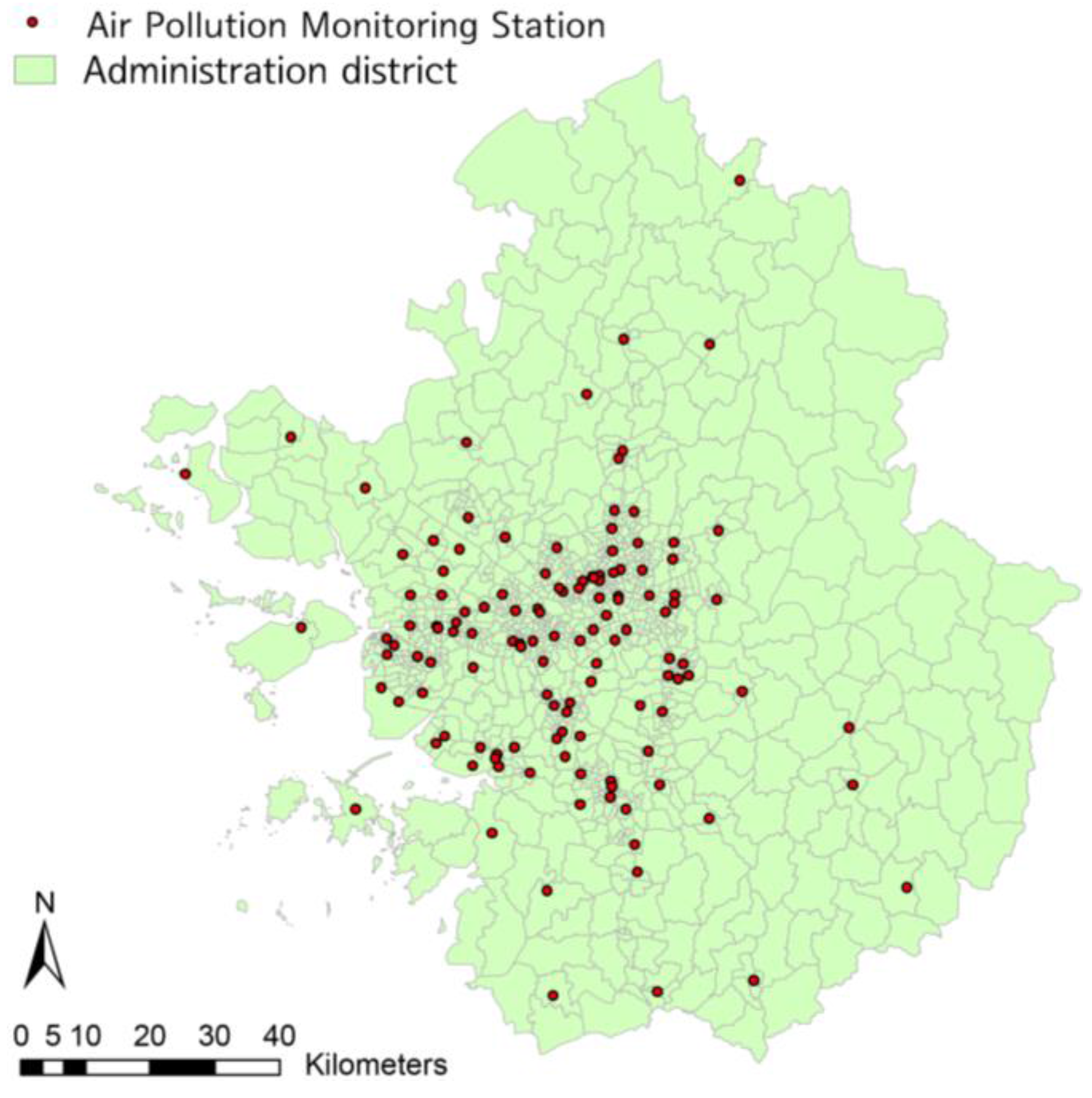
3.1. Context
3.2. Data and Key Variables
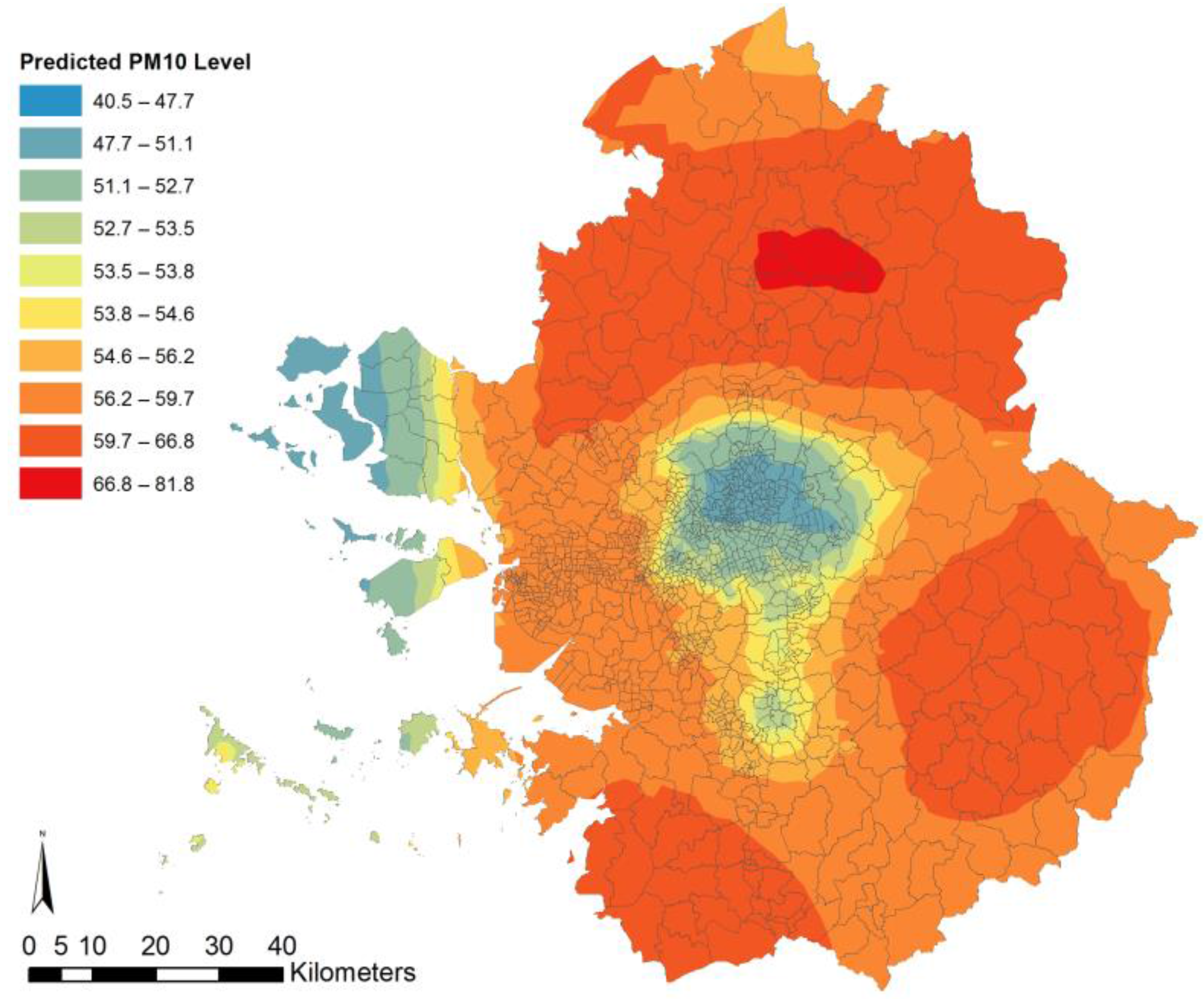
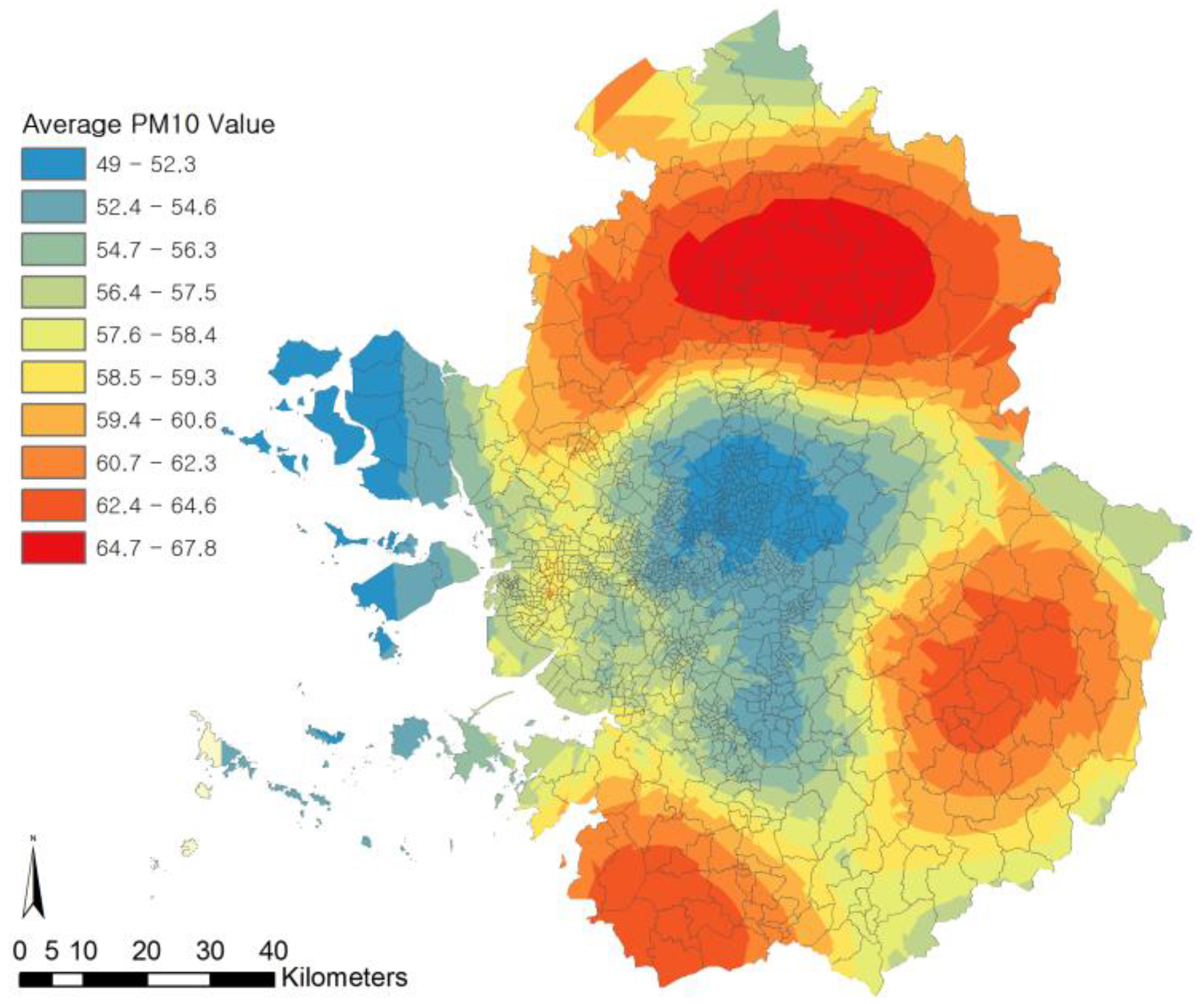
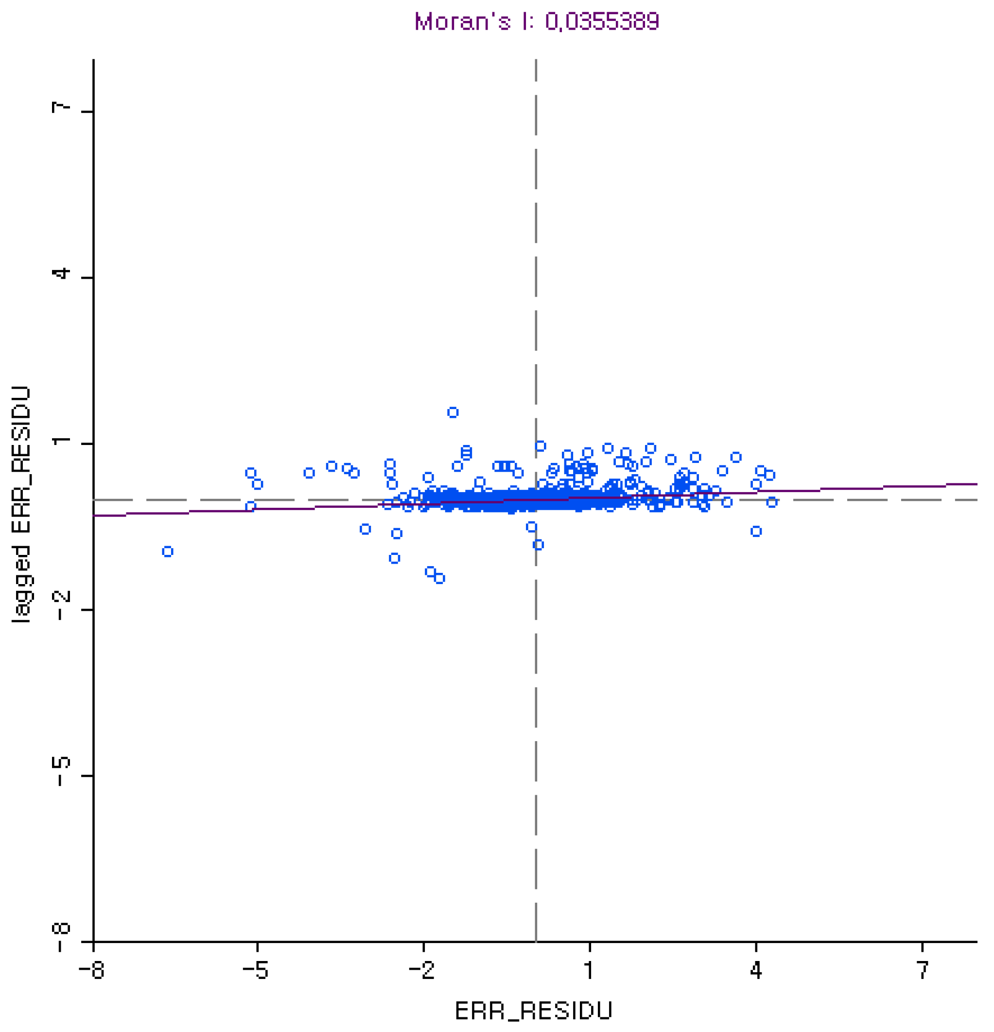
3.3. Spatial Regression Model
4. Analysis Results
5. Conclusions
Acknowledgments
Author Contributions
Conflicts of Interest
Appendix

| Variables | Road 1.0 | Road 0.9 | Road 0.8 | Road 0.7 | Road 0.6 |
|---|---|---|---|---|---|
| Coef. | Coef. | Coef. | Coef. | Coef. | |
| (S.E.) | (S.E.) | (S.E.) | (S.E.) | (S.E.) | |
| p-Value | p-Value | p-Value | p-Value | p-Value | |
| Coefficient | 48.337 *** | 47.075 *** | 47.197 *** | 48.218 *** | 49.301 *** |
| (0.531) | (0.631) | (0.635) | (0.587) | (0.571) | |
| 0.000 | 0.000 | 0.000 | 0.000 | 0.000 | |
| ln (Bus Traffic) | −0.240 ** | −0.229 * | −0.209 * | −0.168 | −0.143 |
| −0.081 | −0.096 | −0.097 | −0.089 | −0.087 | |
| 0.003 | 0.017 | 0.03 | 0.061 | 0.1 | |
| ln (Total Traffic) | 0.509 *** | 0.529 *** | 0.492 *** | 0.398 *** | 0.317 *** |
| −0.092 | −0.11 | −0.111 | −0.102 | −0.099 | |
| 0.000 | 0.000 | 0.000 | 0.000 | 0.000 | |
| Population Density (1000 persons/km2) | 0.000 | 0.000 | −0.001 | −0.001 | 0.000 |
| −0.003 | −0.004 | −0.004 | −0.004 | −0.004 | |
| 0.918 | 0.918 | 0.816 | 0.879 | 0.922 | |
| Employee Density (1000 persons/km2) | −0.015 *** | −0.013 * | −0.011 * | −0.007 | −0.003 |
| −0.005 | −0.005 | −0.005 | −0.005 | −0.005 | |
| 0.001 | 0.012 | 0.042 | 0.16 | 0.591 | |
| Ratio of Manufacturing Employees (%) | 4.878 *** | 5.847 *** | 5.923 *** | 5.027 *** | 3.033 * |
| −1.221 | −1.451 | −1.461 | −1.351 | −1.313 | |
| 0.000 | 0.000 | 0.000 | 0.000 | 0.021 | |
| Administrative District Area (km2) | −0.003 | −0.002 | −0.002 | 0 | 0.001 |
| −0.002 | −0.002 | −0.002 | −0.002 | −0.002 | |
| 0.128 | 0.3 | 0.422 | 0.916 | 0.596 | |
| Power Plant (dummy) | −0.166 | −0.324 | −0.203 | −0.085 | 0.159 |
| −0.301 | −0.358 | −0.36 | −0.333 | −0.324 | |
| 0.58 | 0.366 | 0.573 | 0.798 | 0.624 | |
| Intersection Density (unit/m) | 0.001 | −0.001 | −0.005 | −0.009 | −0.012 |
| −0.01 | −0.012 | −0.012 | −0.011 | −0.011 | |
| 0.937 | 0.926 | 0.686 | 0.435 | 0.251 | |
| Park Density (%) | −0.151 | −0.280 | −0.177 | −0.012 | 0.193 |
| −0.194 | −0.231 | −0.232 | −0.215 | −0.209 | |
| 0.437 | 0.225 | 0.447 | 0.957 | 0.356 | |
| Building Coverage Ratio (%) | 0.147 | 0.116 | 0.225 | 0.309 | 0.464 |
| −0.481 | −0.572 | −0.576 | −0.532 | −0.517 | |
| 0.76 | 0.839 | 0.696 | 0.561 | 0.369 | |
| Land Use Diversity | 0.077 | 0.037 | 0.076 | 0.132 | 0.155 |
| −0.196 | −0.233 | −0.234 | −0.216 | −0.21 | |
| 0.696 | 0.872 | 0.746 | 0.543 | 0.461 | |
| Green Belt (dummy) | 0.068 | 0.083 | 0.102 | 0.113 | 0.112 |
| −0.08 | −0.096 | −0.096 | −0.089 | −0.086 | |
| 0.398 | 0.384 | 0.29 | 0.205 | 0.196 | |
| Distance from the Yellow Sea (km) | 0.031 ** | 0.027 * | 0.026 | 0.029 * | 0.032 ** |
| −0.011 | −0.013 | −0.013 | −0.012 | −0.012 | |
| 0.006 | 0.043 | 0.054 | 0.021 | 0.008 | |
| Lamda (λ) | 0.998 *** | 0.998 *** | 0.998 *** | 0.999 *** | 0.999 *** |
| −0.002 | −0.001 | −0.001 | −0.001 | −0.001 | |
| 0 | 0 | 0 | 0 | 0 | |
| n | 1097 | 1097 | 1097 | 1097 | 1097 |
References
- Ostro, B.; Roth, L.; Malig, B.; Marty, M. The effects of fine particle components on respiratory hospital admissions in children. Environ. Health Perspect. 2009, 117, 475–480. [Google Scholar] [CrossRef] [PubMed]
- Mishra, S.; Ye, X.; Ducca, F.; Knaap, G.J. A functional integrated land use-transportation model for analyzing transportation impacts in the Maryland-Washington, DC Region. Sustain. Sci. Pract. Policy 2011, 7, 60–69. [Google Scholar]
- Brunekreef, B.; Holgate, S.T. Air pollution and health. Lancet 2002, 360, 1233–1242. [Google Scholar] [CrossRef]
- Pope, C.A.; Dockery, D.W. Health Effects of Fine Particulate Air Pollution: Lines That Connect. J. Air Waste Manag. 2006, 56, 709–742. [Google Scholar] [CrossRef]
- Beelen, R.; Hoek, G.; Brandt, P.A.; Goldbohm, R.A.; Fischer, P.; Schouten, L.J.; Armstrong, B.; Brunekreef, B. Long-Term exposure to traffic-related air pollution and lung cancer risk. Epidemiology 2008, 19, 702–710. [Google Scholar] [CrossRef] [PubMed]
- Sinclair, A.H.; Edgerton, E.S.; Wyzga, R.; Tolsma, D. A two-time-period comparison of the effects of ambient air pollution on outpatient visits for acute respiratory illnesses. J. Air Waste Manag. 2010, 60, 163–175. [Google Scholar] [CrossRef]
- Beelen, R.; Voogt, M.; Duyzer, J.; Zandveld, P.; Hoek, G. Comparison of the performances of land use regression modelling and dispersion modelling in estimating small-scale variations in long-term air pollution concentrations in a Dutch urban area. Atmos. Environ. 2010, 44, 4614–4621. [Google Scholar] [CrossRef]
- Gulliver, J.; Briggs, D. STEMS-Air: A simple GIS-based air pollution dispersion model for city-wide exposure assessment. Sci. Total Environ. 2011, 409, 2419–2429. [Google Scholar] [CrossRef] [PubMed]
- Stanek, L.W.; Sacks, J.D.; Dutton, S.J.; Dubois, J.-J. Attributing health effects to apportioned components and sources of particulate matter: An evaluation of collective results. Atmos. Environ. 2011, 45, 5655–5663. [Google Scholar] [CrossRef]
- Gahlot, V.; Swami, B.L.; Parida, M.; Kalla, P. User oriented planning of bus rapid transit corridor in GIS environment. Int. J. Sustain. Built Environ. 2012, 1, 102–109. [Google Scholar] [CrossRef]
- Rijnders, E.; Janssen, N.A.; Vliet, P.H.; Brunekreef, B. Personal and outdoor nitrogen dioxide concentrations in relation to degree of urbanization and traffic density. Environ. Health Perspect. 2001, 109, 411–417. [Google Scholar] [CrossRef] [PubMed]
- Rohr, A.C.; Wyzga, R.E. Attributing health effects to individual particulate matter constituents. Atmos. Environ. 2012, 62, 130–152. [Google Scholar] [CrossRef]
- Zbieranowski, A.L.; Aherne, J. Ambient concentrations of atmospheric ammonia, nitrogen dioxide and nitric acid across a rural-urban-agricultural transect in southern Ontario, Canada. Atmos. Environ. 2012, 62, 481–491. [Google Scholar] [CrossRef]
- Beverland, I.J.; Robertson, C.; Yap, C.; Heal, M.R.; Cohen, G.R.; Henderson, D.E.J.; Hart, C.L.; Agius, R.M. Comparison of models for estimation of long-term exposure to air pollution in cohort studies. Atmos. Environ. 2012, 62, 530–539. [Google Scholar] [CrossRef]
- OECD. The Cost of Air Pollution. Available online: http://oecd.org/env/the-cost-of-air-pollution-9789264210448-en.htm (accessed on 5 January 2016).
- Gueguen, F.; Stille, P.; Dietze, V.; Giere, R. Chemical and isotopic properties and origin of coarse airborne particles collected by passive samplers in industrial, urban, and rural environments. Atmos. Environ. 2012, 62, 631–645. [Google Scholar] [CrossRef]
- Molina, M.J.; Molina, L.T. Megacities and atmospheric pollution. J. Air Waste Manag. 2004, 54, 644–680. [Google Scholar] [CrossRef]
- Parrish, D.D.; Zhu, T. Clean air for megacities. Science 2009, 326, 674–675. [Google Scholar] [CrossRef] [PubMed]
- Borge, R.; Miguel, I.; Paz, D.; Lumbreras, J.; Perez, J.; Rodriguez, E. Comparison of road traffic emission models in Madrid (Spain). Atmos. Environ. 2012, 62, 461–471. [Google Scholar] [CrossRef]
- National Institute of Environmental Research, South Korea. National Air Pollutants Emission 2010. Available online: http://airemiss.nier.go.kr/module/statistics/causeStatistics.do (accessed on 5 January 2016). (In Korean)
- Seoul Metropolitan Government South Korea. Available online: http://env.seoul.go.kr/archives/37971 (accessed on 10 October 2015).
- Ministry of Environment, South Korea. Air Quality Management Plan of Capitol Region. Available online: http://me.go.kr/home/web/policy_data/read.do;jsessionid=glhceGxF7sOz1FaBJPj11k7e4ll8uAj9WqeKKPMLoE9QjQDWOtMLLku4kuUlMNpW.meweb2vhost_servlet_engine1?pagerOffset=30&maxPageItems=10&maxIndexPages=10&searchKey=&searchValue=&menuId=10262&orgCd=&condition.code=A3&seq=6482 (accessed on 10 October 2015). (In Korean)
- Cervero, R. Transit Oriented Development’s Ridership Bonus: A Product of Self-Selection and Public Policies; University of California Press: Berkeley, CA, USA, 2006; Available online: http://escholarship.org/uc/item/8jin8g0hc (accessed on 10 October 2015).
- Sung, H.G.; Oh, J.T. Transit-oriented development in a high-density city: Identifying its association with transit ridership in Seoul, Korea. Cities 2011, 28, 70–82. [Google Scholar] [CrossRef]
- Ewing, R.; Cervero, R. Travel and the built environment: A synthesis. Transp. Res. Rec. 2001, 1780, 87–114. [Google Scholar] [CrossRef]
- Cervero, R. Mixed land uses and commuting: Evidence from the American housing survey. Transp. Res. A Policy Pract. 1996, 30, 361–377. [Google Scholar] [CrossRef]
- Cervero, R.; Murakami, J. Rail and property development in Hong Kong: Experiences and extensions. Urban Stud. 2010, 46, 2019–2043. [Google Scholar] [CrossRef]
- Sohn, D.W.; Kim, J. Analysis of the relationships between land use characteristics of urban transit centers and the level of transit usage: Case studies of Seoul metropolitan area. J. Urban Desi. Inst. Korea 2010, 11, 33–44. [Google Scholar]
- Kim, S.Y.; Jo, A.R.; Baek, I.G.; Lee, M.H. An analysis of influencing relationship between density and TOD planning factors in Seoul subway station areas. J. Korea Plan. 2014, 49, 279–303. [Google Scholar]
- Scungio, M.; Arpino, F.; Stabile, L.; Buonanno, G. Numerical simulation of ultrafine particle dispersion in urban street canyons with the Spalart-Allmaras turbulence model. Aerosol Air Qual. Res. 2013, 13, 1423–1437. [Google Scholar] [CrossRef]
- Scungio, M.; Arpino, F.; Cortellessa, G.; Buonanno, G. Detached eddy simulation of turbulent flow in isolated street canyons of different aspect ratios. Atmos. Pollut. Res. 2015, 6, 351–364. [Google Scholar] [CrossRef]
- Park, S.R.; Han, K.M. Contribution of long-range transported air pollution from China to particulate matter over Korean Peninsula. J. Korean Soc. Hazard Mitig. 2014, 14, 26–36. (In Korean) [Google Scholar]
- Park, I.S.; Lee, S.J.; Lee, Y.H.; Kim, J.C.; Kim, S.K.; Lee, J.B.; Song, H.D.; Kim, J.H.; Lee, D.W.; Lee, D.G. The estimation of long-range transboundary air pollutants from China. In Proceedings of the 38th Meeting of KOASE (Korean Society for Atmospheric Environment), Seosan, Korea, 11–13 November 2004.
- Cascajo, R.; Farber, S.; Jorda, P.; Paez, A.; Monzon, A. Urban form and bus ridership in Spanish cities. In Proceedings of the 12th World Conference on Transport Research, Lisbon, Portugal, 11–15 July 2010; Available online: http://www.wctrs-society.com/wp/wp-content/uploads/abstracts/lisbon/selected/01526.pdf (accessed on 7 January 2016).
- Thompson, G.; Brown, J.; Bhattacharya, T. What really matters for increasing transit ridership: Understanding the determinants of transit ridership demand in Broward County, Florida. Urban Stud. 2012, 49, 3327–3345. [Google Scholar] [CrossRef]
- Wong, D.W.; Yuan, L.; Perlin, S.A. Comparison of spatial interpolation methods for the estimation of air quality data. J. Expo. Anal. Environ. Epidemiol. 2004, 14, 404–415. [Google Scholar] [CrossRef] [PubMed]
- Ross, Z.; English, P.B.; Scale, R.; Gunier, R.; Smorodinsky, S.; Wall, S.; Jerrett, M. Nitrogen dioxide prediction in Southern California using land use regression modeling: Potential for environmental health analyses. J. Expo. Sci. Environ. Epidemiol. 2006, 16, 106–114. [Google Scholar] [CrossRef] [PubMed]
- Briggs, D.J.; Collins, S.; Elliott, P.; Fischer, P.; Kingham, S.; Lebret, E.; Pryl, L.; Reeuwijk, H.V.; Smallbone, K.; Veen, A.V.D. Mapping urban air pollution using GIS: A regression-based approach. Int. J. Geogr. Inf. Sci. 2010, 11, 699–718. [Google Scholar] [CrossRef]
- Jerrett, M.; Arain, M.A.; Kanaroglou, P.; Beckerman, B.; Crouse, D.; Gilbert, N.L.; Brook, J.R.; Finkelstein, N.; Finkelstein, M.M. Modeling the intra-urban variability of ambient traffic pollution in Toronto, Canada. J. Toxicol. Environ. Health A 2007, 70, 19–34. [Google Scholar] [CrossRef] [PubMed]
- Oh, K.S.; Chung, H.B. The influence of urban development density on air pollution. J. Korea Plan. 2007, 42, 197–210. [Google Scholar]
- Kim, B.S. A Study on the effect of urban spatial structure characteristics on CO2 emission. J. Korea Plan. 2013, 48, 225–226. [Google Scholar]
- Kim, H.J.; Jun, M.J. Analysis on relationship between urban development characteristics and air pollution level—A Case of Seoul Metropolitan Region. J. Korea Plan. 2014, 49, 151–167. [Google Scholar] [CrossRef]
- Anselin, L. Local indicators of spatial association—LISA. Geogr. Anal. 1995, 27, 93–115. [Google Scholar] [CrossRef]
- Buonanno, G.; Dell’Isola, M.; Stabile, L.; Viola, A. Critical aspects of the uncertainty budget in the gravimetric PM measurements. Measurement 2011, 44, 139–147. [Google Scholar] [CrossRef]
- Shin, S.E.; Jung, C.H.; Kim, Y.P. Analysis of the measurement difference for the PM10 concentrations between beta-ray absorption and gravimetric methods at Gosan. Aerosol Air Qual. Res. 2011, 11, 846–853. [Google Scholar] [CrossRef]
- Ministry of Environment, South Korea. Air Quality Management Criteria. Available online: http://www.me.go.kr/mamo/web/index.do?menuId=586 (accessed on 10 October 2015).
- Griffith, D.A. Spatial Autocorrelation; University of Texas at Dallas: Richardson, TX, USA, 2009; Available online: http://booksite.elsevier.com/brochures/hugy/SampleContent/Spatial-Autocorrelation.pdf (accessed on 20 September 2015).
- Blazquez, C.A.; Celis, M.S. A spatial and temporal analysis of child pedestrian crashes in Santiago, Chile. Accid. Anal. Prev. 2013, 50, 304–311. [Google Scholar] [CrossRef] [PubMed]
- Truong, L.; Somenahalli, S. Using GIS to identify pedestrian-vehicle crash hot spots and unsafe bus stops. J. Public Transp. 2011, 14, 99–114. [Google Scholar] [CrossRef]
- Lee, S.Y.; Lee, J.S. Neighborhood environmental factors affecting child and old adult pedestrian accident. J. Urban Desi Inst. Korea 2014, 15, 5–15. (In Korean) [Google Scholar]


| Variable | Mean | Std. Dev. | Min | Max | |
|---|---|---|---|---|---|
| Outcome Variables | PM10 (μg/m3) | 55.515 | 3.587 | 49.271 | 67.436 |
| Traffic Variables | Bus Traffic | 18,101.47 | 13,481.31 | 77.765 | 145,423.3 |
| ln (Bus Traffic) | 9.507 | 0.916 | 4.354 | 11.887 | |
| Total Traffic | 102,541.2 | 72,559.18 | 683.055 | 784,550.3 | |
| ln (Total Traffic) | 11.299 | 0.783 | 6.527 | 13.573 | |
| Socio-economic Variables | Population Density (1000 persons/km2) | 15.754 | 13.375 | 0.002 | 56.112 |
| Employee Density (1000 persons/km2) | 5.037 | 7.829 | 0.000 | 90.510 | |
| Ratio of Manufacturing Employees (%) | 1.994 | 5.043 | 0.000 | 87.576 | |
| Environmental Variables | Administrative District Area (km2) | 10.872 | 22.816 | 0.185 | 246.956 |
| Power Plant (dummy) | 0.006 | 0.000 | 1.000 | ||
| Intersection Density (unit/m) | 8.133 | 4.995 | 0.642 | 26.457 | |
| Park Density (%) | 0.096 | 0.147 | 0.000 | 0.847 | |
| Building Coverage Ratio (%) | 0.164 | 0.124 | 0.000 | 0.524 | |
| Land Use Diversity | 0.443 | 0.139 | 0.000 | 0.854 | |
| Green Belt (dummy) | 0.174 | 0.000 | 1.000 | ||
| Distance from Yellow Sea (km) | 66.979 | 18.039 | 0.000 | 136.101 | |
| Variable | Model 1: OLS | Model 2: SEM | ||
|---|---|---|---|---|
| Coef. | (S.E.) | Coef. | (S.E.) | |
| Coefficient | 52.911 *** | 1.583 | 48.337 *** | 0.508 |
| ln (Bus Traffic) | −1.520 *** | 0.249 | −0.240 ** | 0.080 |
| ln (Total Traffic) | 1.730 *** | 0.287 | 0.509 *** | 0.091 |
| Population Density (1000 persons/km2) | −0.057 *** | 0.011 | 0.000 | 0.003 |
| Employee Density (1000 persons/km2) | −0.117 *** | 0.014 | −0.015 *** | 0.004 |
| Ratio of Manufacturing Employees (%) | 17.207 *** | 2.636 | 4.878 *** | 1.205 |
| Administrative District Area (km2) | 0.030 *** | 0.005 | −0.002 | 0.002 |
| Power Plant (dummy) | −1.634 | 1.035 | −0.166 | 0.297 |
| Intersection Density (unit/m) | −0.230 *** | 0.029 | 0.001 | 0.010 |
| Park Density (%) | −2.649 *** | 0.640 | −0.151 | 0.192 |
| Building Coverage Ratio (%) | 6.517 *** | 1.600 | 0.147 | 0.476 |
| Land Use Diversity | 0.367 | 0.678 | 0.077 | 0.193 |
| Green Belt (dummy) | −0.729 ** | 0.250 | 0.068 | 0.080 |
| Distance from the Yellow Sea (km) | −0.011 ** | 0.006 | 0.031 ** | 0.011 |
| Lamda (λ) | 0.998 *** | 0.002 | ||
| R-Squared | 0.439 | 0.951 | ||
| n | 1097 | 1097 | ||
| Robust LM (lag) | 149.115 *** | |||
| Robust LM (error) | 2258.293 *** | |||
© 2016 by the authors; licensee MDPI, Basel, Switzerland. This article is an open access article distributed under the terms and conditions of the Creative Commons Attribution (CC-BY) license (http://creativecommons.org/licenses/by/4.0/).
Share and Cite
Her, J.; Park, S.; Lee, J.S. The Effects of Bus Ridership on Airborne Particulate Matter (PM10) Concentrations. Sustainability 2016, 8, 636. https://doi.org/10.3390/su8070636
Her J, Park S, Lee JS. The Effects of Bus Ridership on Airborne Particulate Matter (PM10) Concentrations. Sustainability. 2016; 8(7):636. https://doi.org/10.3390/su8070636
Chicago/Turabian StyleHer, Jaeseok, Sungjin Park, and Jae Seung Lee. 2016. "The Effects of Bus Ridership on Airborne Particulate Matter (PM10) Concentrations" Sustainability 8, no. 7: 636. https://doi.org/10.3390/su8070636
APA StyleHer, J., Park, S., & Lee, J. S. (2016). The Effects of Bus Ridership on Airborne Particulate Matter (PM10) Concentrations. Sustainability, 8(7), 636. https://doi.org/10.3390/su8070636