1. Introduction
Farmland abandonment refers to the phenomenon of cultivated land remaining unused and idle for more than one year [
1]. During the period of the Industrial Revolution, there are records on the recovery of large forest areas [
2,
3]. Generally, agricultural land use changes include farmland expansion due to land exploitation [
4,
5], farmland abandonment induced by rural-to-urban population migration [
6], and conversion associated with urbanization and industrialization [
7]. During the second half of the 20th century, the global mountain population continued to decrease, and the vast land abandonment phenomenon occurred [
8,
9]. In such areas as the Mediterranean region, North America, Europe, and Japan, events such as farmland abandonment, the increase of forest areas, and the discontinuation of marginal farmland production [
10,
11,
12,
13] can be considered as typical in cases of farmland marginalization [
14,
15,
16,
17,
18,
19].
Farmland abandonment is a synthesized function of economic development, policy system, natural factors, technology development, and other driving forces. As such, it has long been a contentious issue worldwide because of difficulties in defining, measuring, monitoring and studying this process [
20]. In Europe, Japan, and other developed countries and regions [
18,
21,
22], the development of urbanization and industrialization caused the rural population to move out, and non-agriculturalization resulted in a large reduction in agricultural labor in mountainous regions. The increase in opportunity costs of farming caused farmland marginalization [
23], and was the root cause of the large-scale farmland abandonment in developed countries. With the continuous decrease in the labor force, finally, the farmers had no time to attend to all their land, and part of the land was abandoned [
23]. In addition, the government introduced the policy of supporting the development of marginal regions, rising food prices under the conduction of demand growth or labor price increases, developing new laborsaving technology, expanding the plantation of energy crops, and other factors, all of which would restrict or slow down the development of farmland marginalization and abandonment [
8,
24,
25,
26,
27].
The study of the spatial distribution of farmland abandonment and factors that influence it contributes to a deep understanding of the phenomenon of farmland abandonment. Existing research shows that farmland abandonment is highly concentrated in mountainous regions [
28,
29]. For instance, the farmland abandonment rate of mountainous agricultural regions in Japan is still about three times that of the plains, and the farmland abandonment rate of mid-level agricultural regions is about 2.5 times that of the plains [
30]. The factors affecting the distribution of farmland abandonment are multifaceted, and include natural conditions, labor force characteristics, the agricultural development level, locational conditions, the economic development level, agricultural policies, et cetera [
31].
China’s cultivated land in suburbs of large cities basically do not face the phenomenon of abandonment due to convenient transportation and good farming conditions, while hilly and mountainous areas far away from the city face a serious problem of farmland abandonment due to barren lands, weak agricultural infrastructure, and remote locations [
32]. Domestic research on farmland abandonment is more often at the macro-theoretical level, such as the phenomenon, mechanisms, and countermeasures of farmland abandonment, etc. Research on farmland abandonment in China reveals the continuing existence of the following deficiencies: Firstly, very few organizations or individuals have specified the scale of farmland abandonment or specific related data; Second, subject to terrain factors, the research in mountainous areas with large fluctuations is mainly based on peasant household surveys, and parcel-level research is limited, especially in China. However, Zhang analyzed multi-scale impact factors of farmland abandonment through a multi-level regression model, and the results revealed that at the parcel level, the explanatory power of impact factors in the spatial distribution of farmland abandonment is as high as 80%, 7% at household level and 13% at village level [
33]. Hence, it is very necessary to study the spatial distribution of farmland abandonment at parcel level.
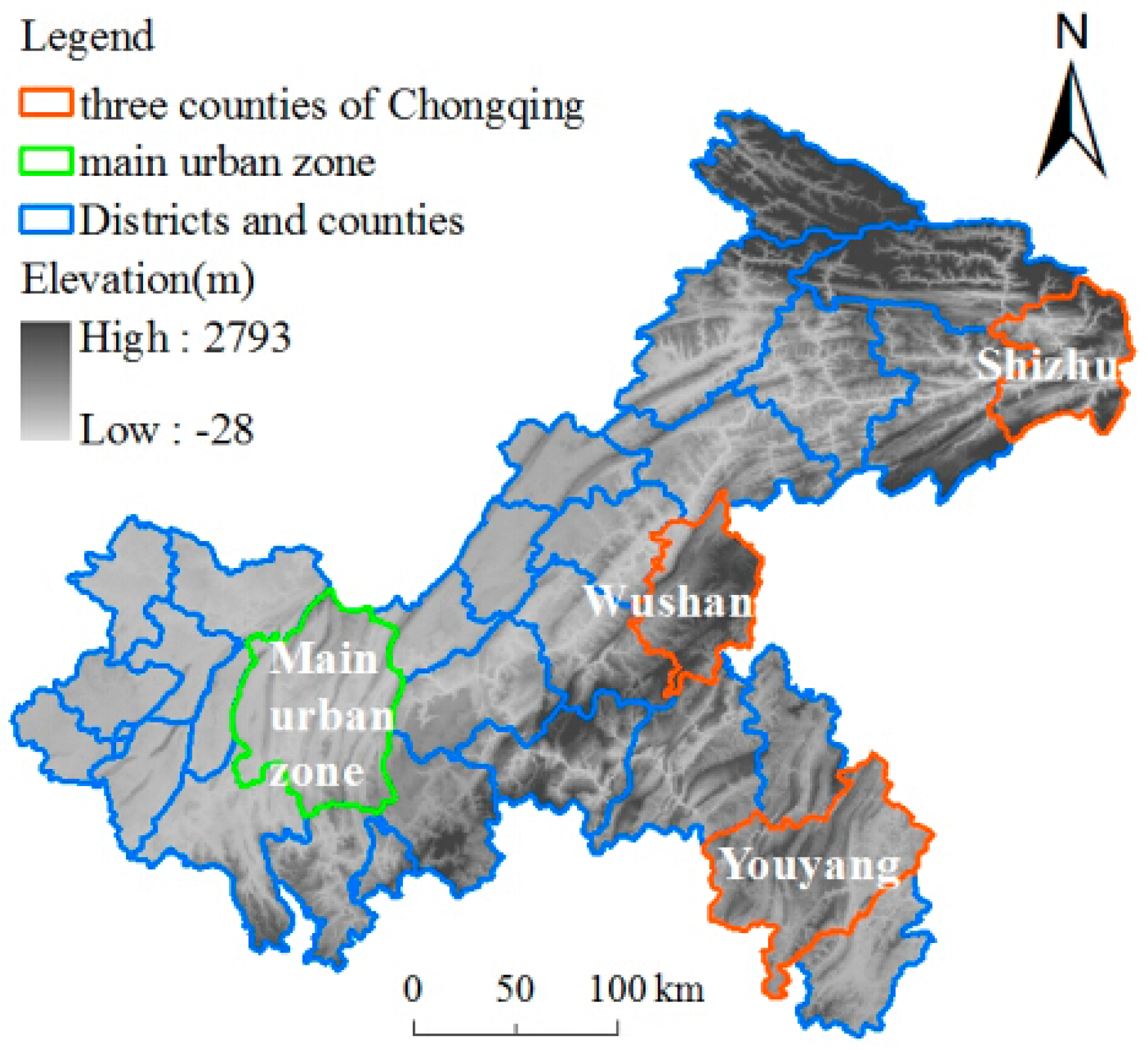
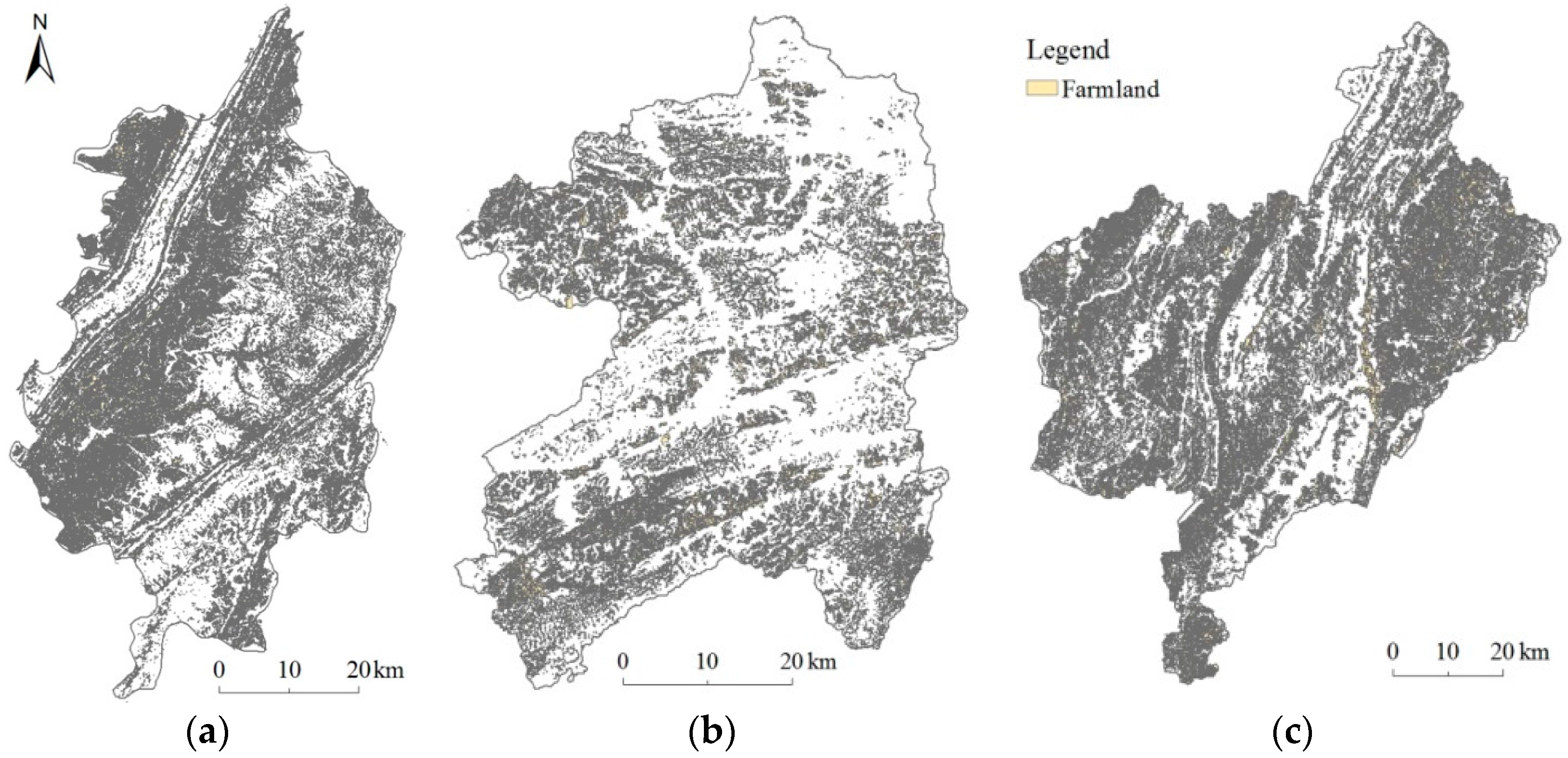
Chongqing municipality, a mountainous city in Southwest China (
Figure 1), was chosen as the main focus of this paper as a massive rural population from this area migrated to cities and towns in recent years. Chongqing is an important area in terms of China’s labor output. Moreover, in 2007, it was approved as a city and countryside synthesis-coordinated reform pilot area; the hilly and mountainous regions cover large jurisdictions and its stark phenomenon of arable land abandonment all make it a representative area useful for comparisons. According to a previous detailed investigation on the various districts and counties in Chongqing, comprehensively considering the spatial distribution of 40 districts and counties in Chongqing, the regional differences of each county’s agricultural production and farmland abandonment, as well as previous research foundations in Chongqing’s multiple counties. As a result, Shizhu, Wushan and Youyang counties were found to adequately represent and reflect the overall situation and characteristics of farmland abandonment in Chongqing city (
Figure 2), Thus, Shizhu, Wushan and Youyang counties were chosen as typical area of Chongqing City, this study extracted data on abandoned farmland parcels and analyzed the spatial distribution of farmland abandonment and its influence factors in Chongqing.
2. Materials and Methods
2.1. Study Area
Chongqing city is located in the inland area of Southwest China, in the upper Yangtze River region, and lies roughly between 28°10’N−32°13’N and 105°11’E−110°11’E, covering an area of approximately 82,400 km
2 (
Figure 1). The land is dominated by hills and mountains with a large slope area, and is thus referred to as the “Mountain City”. Chongqing’s terrain drops from the north and south to the Yangtze River valley, and many hills and low mountains cover the northwestern and central areas, with Daba Mountain to the northeast and Wuling Mountain to the southeast. The annual average temperature of Chongqing is 16 °C–18 °C, and the annual average rainfall is rich—most of the region receives around 1000 mm−1350 mm per year. The 2014 Chongqing census registered a population of 33.75 million people, an urbanization rate of 59.6%, 0.10 ha of arable land per capita, a per capita GDP of 47,859 yuan (calculating the population of permanent residents), and a per capita disposable income of 9490 yuan for farmers. Chongqing has 40 administrative districts and counties, making it a megalopolis with the largest area and population in China. Further, Chongqing is home to China’s currently most administrative jurisdiction unit.
Shizhu county is located to the east of Chongqing City, lies roughly between 29°39’ N−30°32’ N and 107°59’ E−108°34’ E, and has jurisdiction over 32 villages and towns with a total population of 540 thousand people. Further, Shizhu County has a total land area of 3012 km2, 0.05 ha of arable land per capita, and a per capita GDP of 26,487 yuan (calculating the permanent resident populations). Shizhu’s territory is dominated by low and mid-sized mountains as well as plains and hills, and has a humid subtropical monsoon climate with an annual average temperature of 16.5 °C and an average rainfall of 1103 mm annually.
Wushan county is located to the northeast of Chongqing city, lies roughly between 30°45’ N–32°28’ N and 109°33’ E–110°11’ E, and has jurisdiction over 25 villages and towns with a total population of 624,000 people. The county land area totals 2958 km2 with 0.06 ha of arable land per capita, and a per capita GDP of 17,440 yuan (calculating the permanent resident populations). The topography of Wushan is very complex: the mountainous area accounts for 96% of the county, while hills and plains account for only 4% of the area. Wushan has an annual average temperature of 18.4 °C and an average rainfall of 1041 mm annually.
Youyang county is located to the southeast of Chongqing city, lies roughly between 28°19’ N−29°24’ N and 108°18’ E−109°19’ E, and has jurisdiction over 39 villages and towns with a total population of 730,000 people. The total county land area is 5173 km2, making Youyang the largest county in Chongqing. Youyang’s arable land per capita totals 0.18 ha, and its per capita GDP totals 19,634 yuan (calculating the permanent resident populations). The county is very mountainous and is often referred to as being made up of “eight mountains, half water and one and a half farmland”. The area has humid subtropical monsoon climate with an annual average temperature of 14.4 °C and an average rainfall of 1250 mm annually.
2.2. Data Description
In 2011, 1:10,000 topographic maps of Shizhu, Wushan, and Youyang counties in Chongqing city were provided by the forestry bureaus of each county, Shizhu county’s farmland interpretation map of 2011 was provided by Chongqing Normal University, while Wushan and Youyang’s 1:10,000 land utilization charts were provided by the Bureau of Land Resources and Housing Management belonging to each county. Further, the distribution maps of farmland returning to forest (2002–2006) and forest projects (2008–2011) were collected from the Forestry Bureaus of the three counties, and DEM and SLOPE data with a 30 m resolution was gathered from the Geospatial Data Cloud website.
According to a preliminary household survey, the phenomenon of farmland abandonment began to increase rapidly in Chongqing’s mountainous area from the mid-1990s, especially after 2000. Therefore, this article selects 2002−2011 as the study phase, observing data at the regional level, through the abandoned parcel census to understand the size and distribution of abandonment. Regarding the second land utilization investigation data completed in 2011, the scale bar is large (1:10,000) and the artificial drawing is based on a SPOT image. The source of this data is reliable and may thus be utilized as the distribution map layer of the current farmland situation. In the case of the early 2000s, we observed the normal topographic map of 2002, the scale bar of the map is the same, and the ground objects mainly include cultivated land, forests, roads, and houses. One particular cultivated land parcel offered detailed information and clear boundaries, and may be used as the distribution map layer of cultivated land in 2002. Then, the superposition of two period layers provides a farmland parcel distribution map of abandoned farmlands in 2002−2011. The above step obtained information on arable land of abandoned farmlands including cultivated land of abandoned farmlands that returned to forest areas during the period of 2002−2011. The research object of this paper is cultivated land that was voluntarily abandoned by farmers, especially as this particular type of farmland must be removed. We obtained the distribution maps of returning farmland to forest (2002–2006) and forest projects (2008–2011), the scale bar is the same, and contains the village names, tree species, planting year, small spot number, survival rate and other information. This data can be used with two periods of farmland layer overlay to eliminate the cultivated land in order to participate in projects that return farmlands to forest or other afforestation projects.
2.3. Farmland Abandonment Mapping
Regarding portions of the mountainous area in Chongqing city that no longer exist for agricultural production, the influences of input-output, population, and other macro-economic social factors are heavily involved. Further, reasons for this abandonment phenomenon is based on the farmland quality itself or comprehensive production capacity. This article mainly explores the influence factors of farmland abandonment from the latter. To provide detailed data, the current study obtained large-scale distribution maps of abandoned parcels in the three aforementioned counties from 2002 to 2011. Through a sampling survey, abandoned farmland figure spots and Google Earth images were superimposed and contrasted. The extraction accuracy of abandoned farmland parcels is 85.3%, and is thus relatively satisfactory.
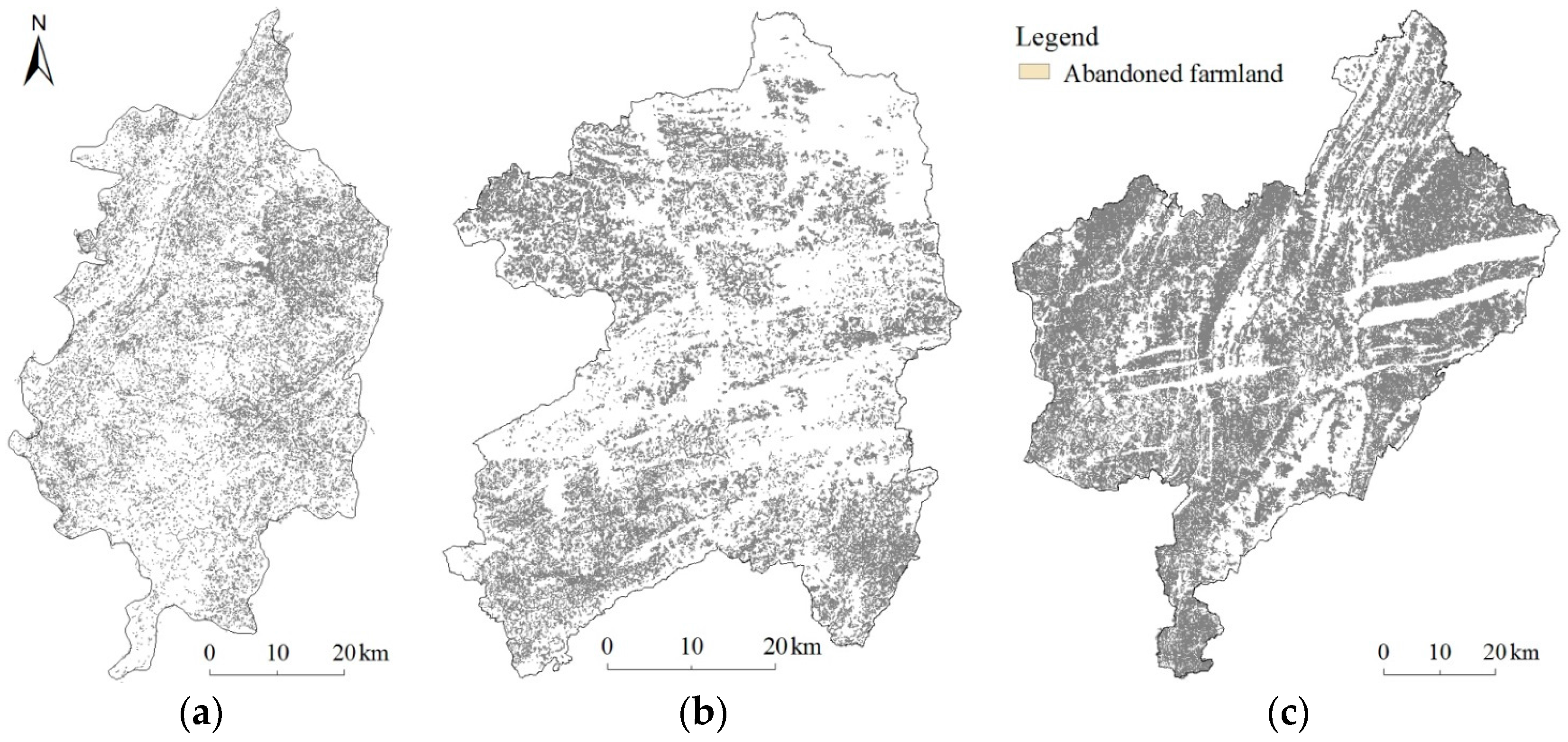
Shizhu, Wushan and Youyang counties of Chongqing City are made up of a total 95 towns. The farmland figure spots extracted from a 2002 topographic map total 260,400 (
Figure 3), while 217,100 farmland figure spots were extracted from the current 2011 land use map. The abandoned farmland figure spots extracted from the processed abandoned farmland map reveal a total of 559,500 (
Figure 4), and the three maps totaled 1,037,000 parcel figure spots, therefore enabling the mathematical statistical analysis of large samples. In sum, based on the samples of 1,037,000 parcel figure spots in three counties, this paper analyzed the spatial distribution of farmland abandonment and its influence factors. This research is also significant as it conducted farmers’ input-output analysis and validates analytical results.
2.4. Methods
In this work, by analyzing the reasons for farmland abandonment at parcel level, each variable that affects farmland abandonment was determined. The calculation methods used were clearly stated. From this basis, the relationship between each variable and the abandonment rate was analyzed first. Then, the probability of abandonment was taken as a dependent variable, each influencing factor was taken as an independent variable, and a logistic regression analysis was performed. In this way, the influence of each variable on the probability of abandonment was determined.
2.4.1. Generation of Explicit Independent Variables
Theoretically, arable land abandonment is the result of parcel farming income not being able to cover costs (that is, the profit is negative); in such cases, the revenue has declined, costs have risen, or both scenarios contribute to the problem. In any case, economic analysis of the reasons behind farmland abandonment can be initiated based on the factors that affect agricultural management income and costs. In recent years, especially since 2003, China’s migrant workers’ wages grew larger, and there is now an increase of 10%−20% every year, meaning that the rural farming labor costs are rising rapidly. This phenomenon has had a great influence on the cost of agricultural land management. For mountain parcels, the resource endowment difference is quite significant, both in regards to the agricultural output performance and the cost of farming. Therefore, based on analysis of the influencing factors of farmland abandonment at the parcel level, this article focuses on the land attribute of affecting agricultural output level and farming costs.
According to the influencing factors of agricultural management benefits and costs, we mainly selected the two groups that have the greatest impact on labor costs and land output. In accordance with the availability of data, the factors that affect the land output only involve parcel slope; meanwhile, the factors influencing labor costs include tillage distance, tillage elevation difference, parcel size, and distance to road, among other factors. In the following, the specific reasons for the selection of elements and the definition of indicators are described.
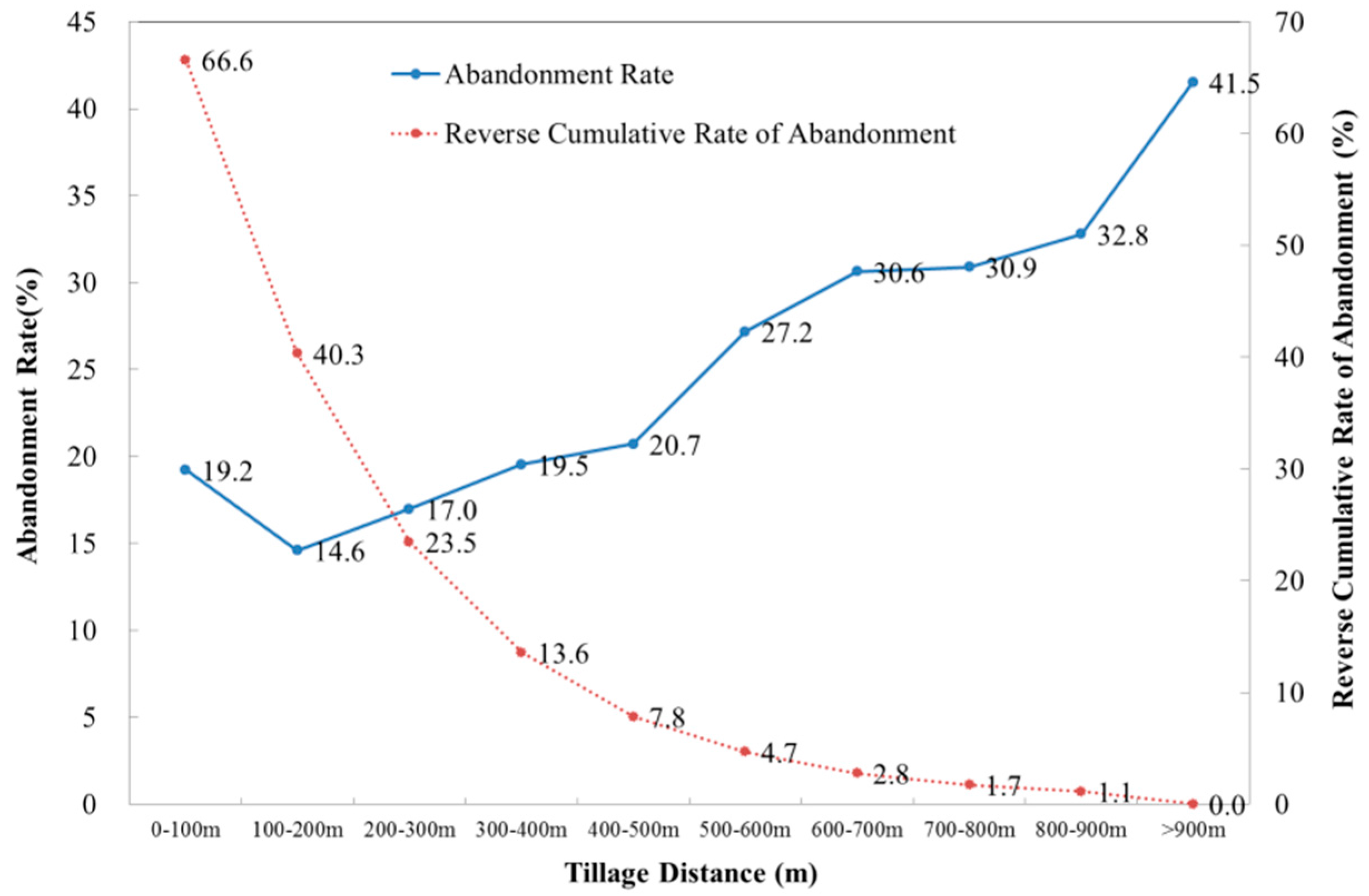
Tillage Distance
Due to such factors as the loss of the rural labor force, for example, farmers will likely abandon arable land if tillage distance is far. Because the mountainous area of Chongqing includes very bumpy roads and other traffic inconveniences, farmers mostly travel on foot from their residential area to their farmland parcel. If the tillage distance is long, farmer’s commuting time is often quite long and the cost of the farming may increase, often motivating farmers to give up such cultivated land parcels. Therefore, tillage distance is an important factor in determining whether farmers make the decision to abandon their lands. The tillage distance variable is represented by the horizontal line distance of farmland parcel to the nearest residential point.
Farmland parcel and settlement distribution maps were used in the study area in 2002. Utilizing the “Feature to Point” tool in ArcGIS 9.3 software (Esri: Redlands, CA, USA, 2011), transfer planar layer of cultivated land parcel and settlement to point map layer, that is, each point represents a planar graph of farmland parcel or settlement. We then utilized the “Near” tools to extract the Euclidean Distance of each cultivated land parcel to the nearest settlement. The distance of farmland parcel to the nearest settlement represents the household’s farming radius, and the distance has an important influence on whether farmers make the decision to abandon. We use the same method to extract the Euclidean Distance of each abandoned farmland parcel to the nearest settlement in 2011, and calculated each figure spot size of farmland parcel and abandoned farmland parcel. In this way, each farmland parcel and abandoned farmland parcel respectively corresponds to one area value and one distance value; partition distance, moreover, we obtained the total abandoned farmland area and total farmland area of each interval, and divided the two to obtain the farmland abandonment rate of each distance interval.
where
is abandonment rate of tillage distance interval in 2011;
is abandoned farmland area of tillage distance interval in 2002−2011;
is farmland area of tillage distance interval in 2002;
n is tillage distance interval.
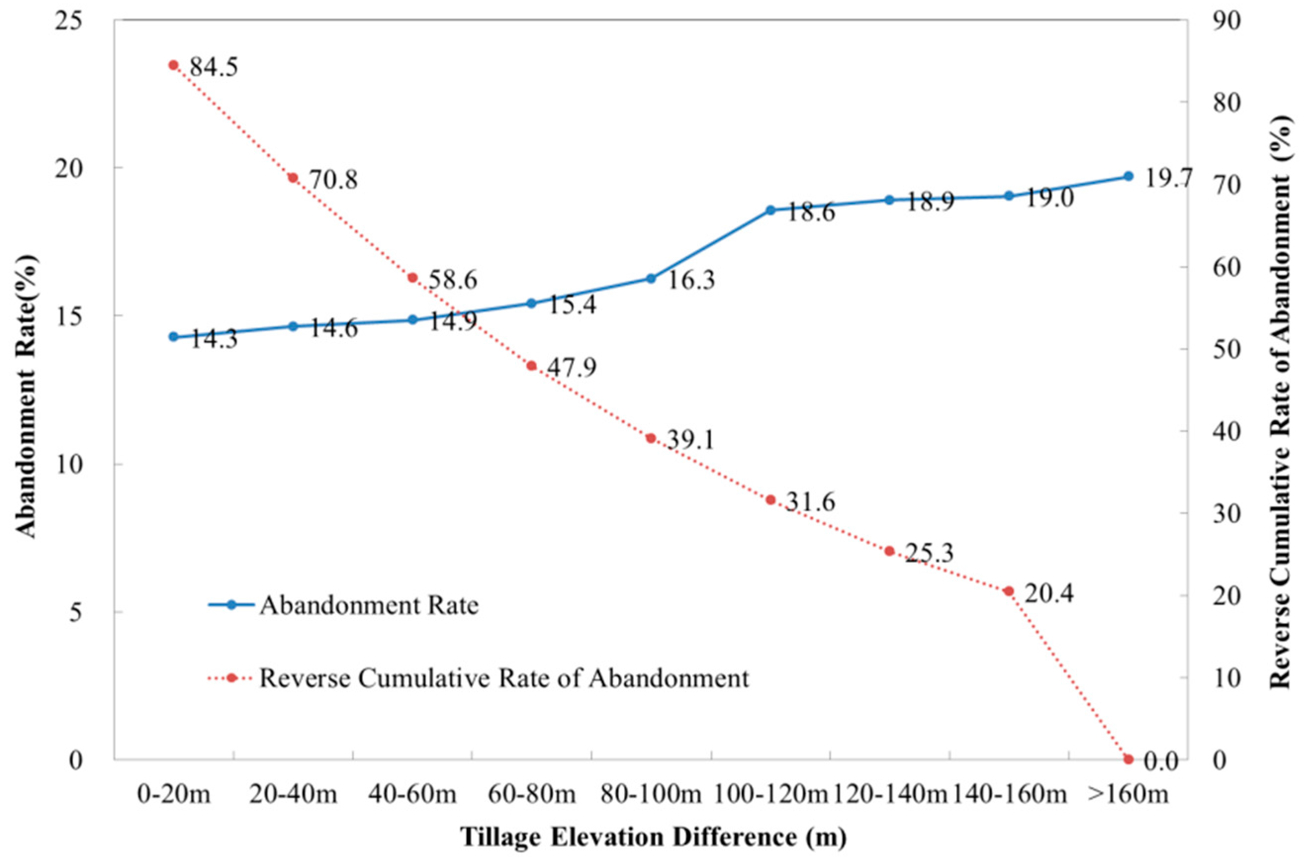
Tillage Elevation Difference
In Chongqing’s mountainous area, arable land parcels are broken, roads are rugged, and traffic is inconvenient. If the elevation difference is big, the commute is often long, the physical strength required to maintain the land is remarkable, and farming costs are high. Thus, tillage elevation difference is also an important factor determining whether or not farmers make the decision to abandon their land. The tillage elevation difference variable is represented by the absolute value of farmland parcel elevation and average village settlement height.
We overlaid the point map layer of farmland and settlement in 2002 onto a DEM image, and used the “Zonal Statistics” tool to extract the elevation of each farmland parcel and settlement. Overlaying the settlement map layer onto the village administrative boundary map, we used the “Summarize” tool to calculate the average elevation of each village settlement. Finally, we utilized the elevation of each farmland parcel to subtract the average elevation of the village settlements, and took the absolute value to equal the elevation of each farmland parcel-relative settlement, namely for tillage elevation difference. We used the same method to extract the elevation of each abandoned farmland parcel-relative settlement in 2011, and calculated each figure spot size of farmland parcel and abandoned farmland parcel. In this way, each farmland parcel and abandoned farmland parcel respectively corresponds to one area value, one relative settlement elevation value to equal the partition tillage elevation difference; further, we obtained the total abandoned farmland area and total farmland area of each interval, and divided the two to obtain the farmland abandonment rate of each tillage elevation difference interval.
where
is abandonment rate of tillage elevation difference interval in 2011;
is abandoned farmland area of relative elevation interval in 2002−2011;
is farmland area of relative elevation interval in 2002;
n is tillage elevation difference interval.
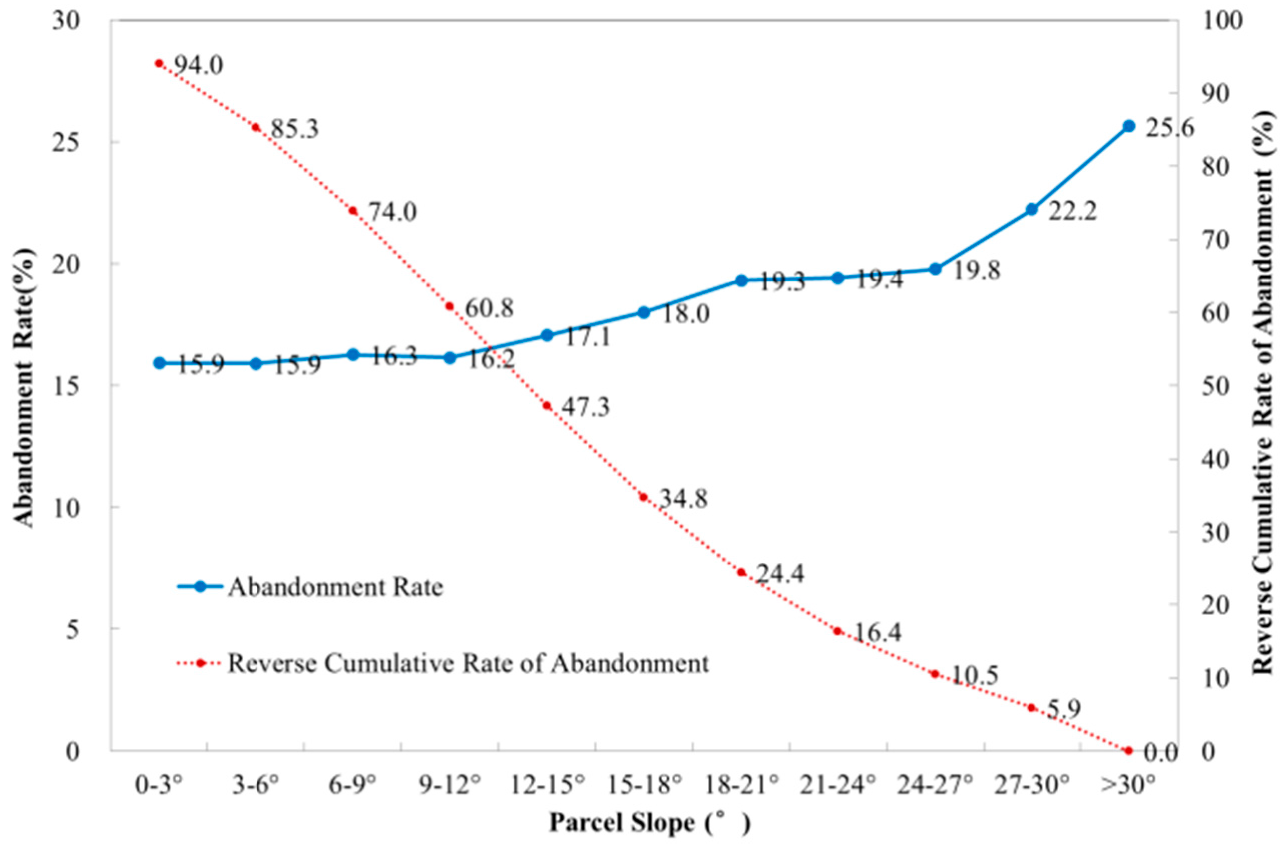
Farmland Parcel Slope
Chongqing’s mountainous land is rugged, complex and changeable, and flat land is scarce. Further, arable lands in Chongqing are most often cultivated on slopes. Generally for these steep cultivated lands, the soil is quite thin, the soil’s water retention is poor, and the output is low and unstable. Moreover, these lands encounter heavy rain floods, leading to the significant problems of soil erosion and nutrient loss; in addition, steep slopes also increase the difficulty of using machinery and decrease the overall farming conditions. When peasants aim to revive wastelands, they first select flat or minimally sloped lands; similarly, when farmers abandon arable land for some reason, it is often the case that the land was significantly sloped, and in cases of farmers retaining their cultivated land, the slope is small and the terrain is relatively flat. Farmland parcel slope is thus another important factor affecting farmland abandonment.
We utilized the farmland parcel distribution map in 2002 and the abandoned farmland parcel distribution map in 2011 in the study area, first using the “Feature to Point” tool to transfer planar layer of farmland parcel and abandoned farmland parcel to point map layer, that is, each point represents a planar graph of farmland parcel or abandoned farmland parcel. We then overlaid the point map layer of farmland and abandoned farmland onto a SLOPE image, and used the “Zonal Statistics” tool to extract the slope of each farmland parcel and abandoned farmland parcel. We then calculated each figure spot size of farmland parcel and abandoned farmland parcel. In this way, each farmland parcel and abandoned farmland parcel respectively corresponds to one area value and one slope value to give the partition slope; further, we calculated the total abandoned farmland area and total farmland area of each interval, and divided the two to obtain the farmland abandonment rate of each slope interval:
where
is abandonment rate of slope interval in 2011;
is abandoned farmland area of slope interval in 2002−2011;
is farmland area of slope interval in 2002;
n is slope interval.
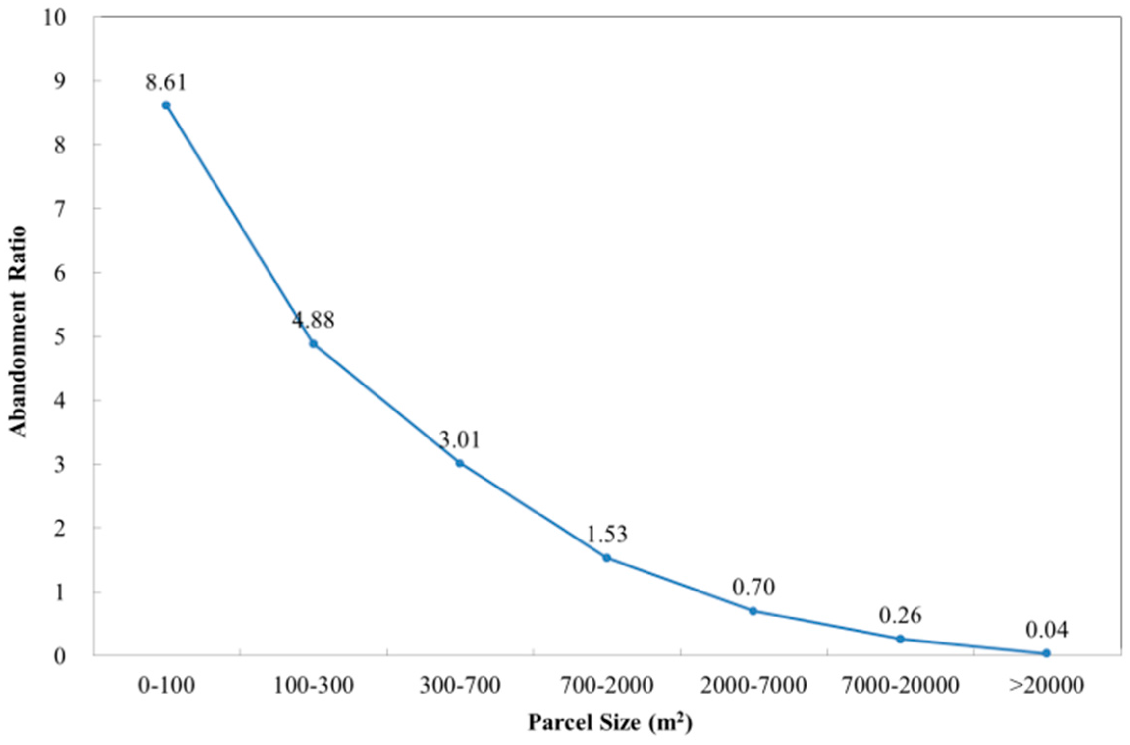
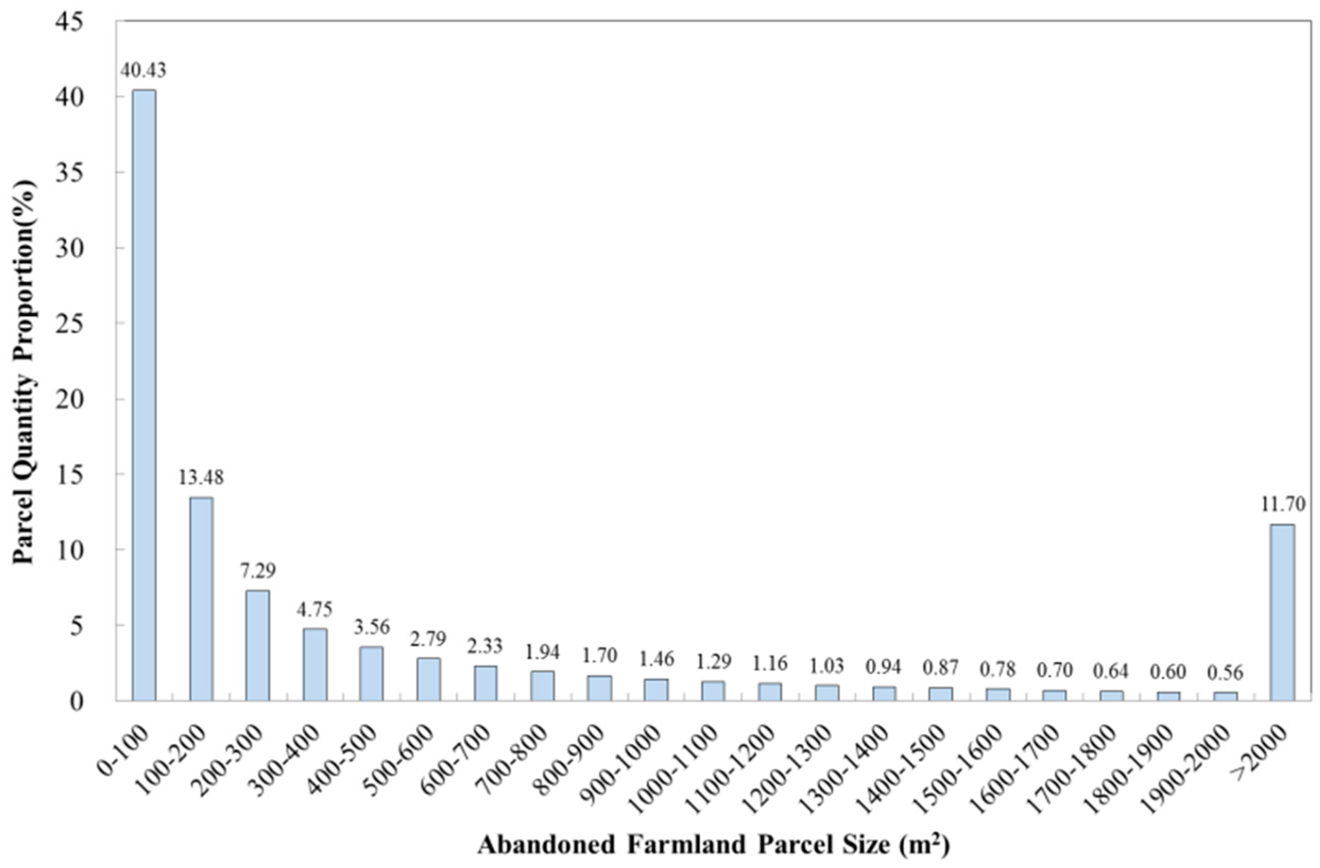
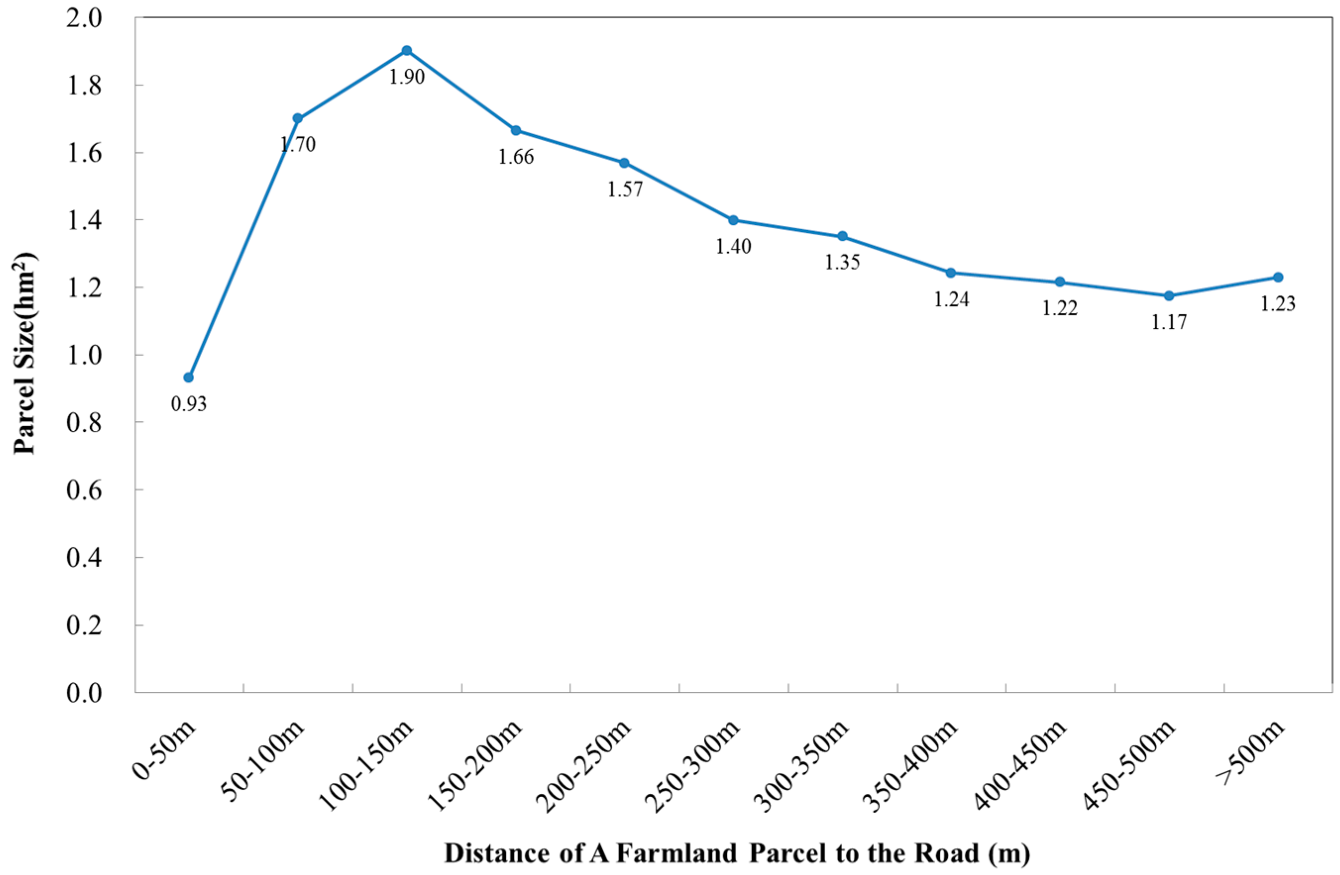
Farmland Parcel Size
Arable land parcels in Chongqing’s mountainous area are more broken, their sizes are more disparate, and their overall differences are quite marked. It is quite difficult to use machinery on fragmentary parcels, which also increases the commuting time. When possible, farmers often choose larger parcels for farming because of management convenience, and the fact that operating costs are relatively low. Therefore, farmland parcel size is also an important factor affecting farmland abandonment.
We utilized the farmland parcel distribution map in 2002 and the abandoned farmland parcel distribution map in 2011 in the study area, first utilizing the “Calculate Geometry” tool to calculate each figure spot size of farmland parcel and abandoned farmland parcel. We then sorted farmland parcel size and abandoned farmland parcel size, respectively, for partition size, then calculated and compared the total abandoned farmland area, total farmland area, and total number of parcels of each interval. Because the abandonment of farmland parcels may at times be only partial abandonments, and partially abandoned farmland parcels shift in other size intervals, the abandoned farmland area may be greater than the overall farmland area in the same size interval after abandoning. Alternatively, the total parcel area may increase in the same area interval after abandoning, leading to an abandonment rate that is greater than one. Therefore, we adopted the concept of “abandonment ratio” in this study; according to this ratio, the abandoned farmland area is divided by farmland area in the same size interval after abandoning:
where
is abandonment ratio of size interval in 2011;
is abandoned farmland area of size interval in 2002−2011;
is farmland area of size interval in 2002;
n is size interval.
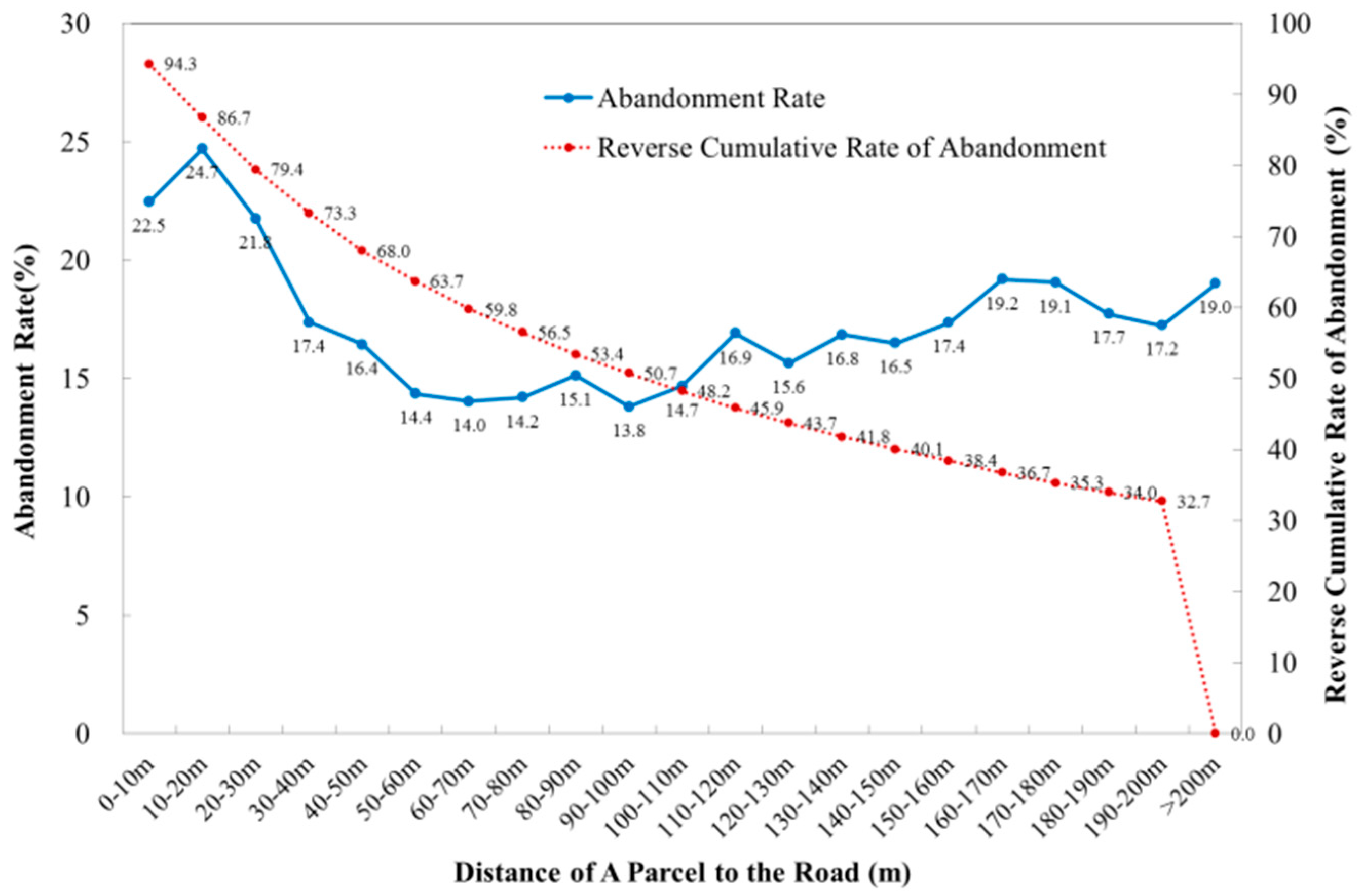
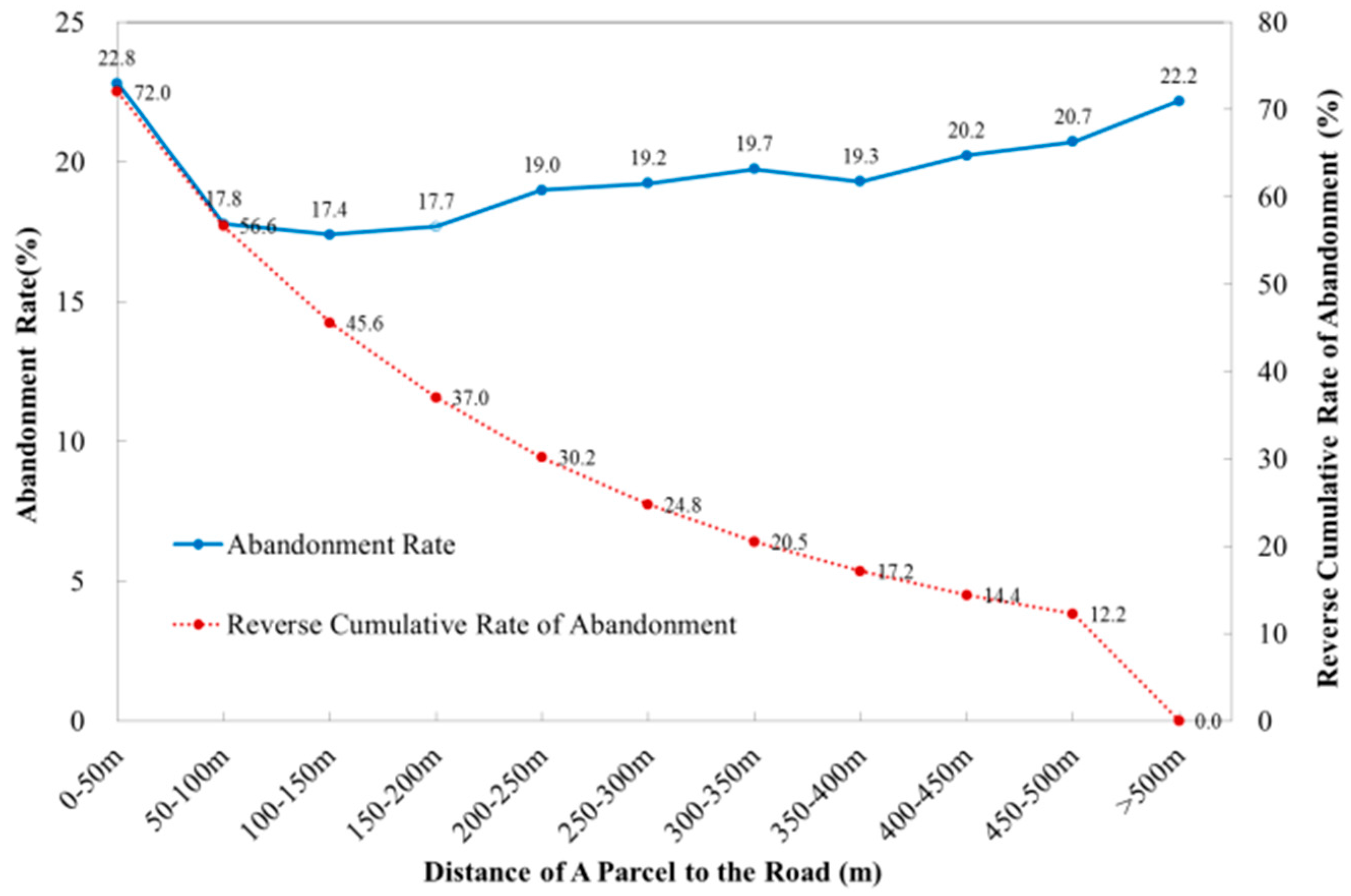
Distance of Parcel to Road
When farmers choose parcels to grow crops, they first choose parcels that are close to the road and with better traffic conditions, in an effort to save travel time and improve labor productivity. Similarly, farmers who have chosen to abandon arable lands had most often chosen parcels that were far from roads and difficult to access. Therefore, the distance of parcel to road may also affect whether farmers make an abandonment decision. This variable is represented by the distance of farmland parcel to the nearest road.
We utilized the road distribution map in the study area, then used the “Near” tools to extract the Euclidean Distance of each cultivated land parcel to the nearest road. The distance of farmland parcel to the nearest road represents the household’s travel farming convenience degree, as the distance may possibly influence whether farmers make the decision to abandon their lands. We utilized the same method to extract the Euclidean Distance of each abandoned farmland parcel to the nearest road in 2011, and calculated each figure spot size of farmland parcel and abandoned farmland parcel. In this way, each farmland parcel and abandoned farmland parcel respectively corresponds to one size value and one distance value to the nearest road, i.e. partition distance; we also calculated the total abandoned farmland area and total farmland area of each interval, and divided the two to obtain the farmland abandonment rate of each distance interval.
where
is abandonment rate of distance to road interval in 2011;
is abandoned farmland area of distance to road interval in 2002−2011;
is farmland area of distance to road interval in 2002;
n is distance to road interval.
where
is average farmland parcel size; A is farmland area; Q is farmland parcel quantity; and
n is interval of distance between parcel and road.
4. Discussion
The article chooses Chongqing municipality, a mountainous city in southwestern China, as the study area, where massive outmigration of the rural population to cities and towns recently occurred. The study extracted abandoned farmland figure spots from farmland distribution maps in 2002 and 2011 at a 1:10,000 scale, and analyzed the spatial distribution characteristics of farmland abandonment and the main influencing factors in Chongqing at the parcel level.
First, these results are different from those reported from a previous study of farmland abandonment at mainly the level of peasant households [
34]; a microscopic analysis at parcel level reveals a strong explanatory power of the factors that influence the distribution of abandoned farmland in mountainous regions. Most existing studies on farmland abandonment are an analysis at a household level, but it is difficult to accurately deduce the overall abandonment situation and spatial distribution difference from a household-level analysis, as the abandonment rate estimated from a peasant household survey is greatly affected by the surveyed households, spatial sampling survey methods, and survey technology. Therefore, the analysis of spatial distribution and of factors influencing farmland abandonment at the parcel level has a rational basis. Zhang’s study found that at parcel level, the explanatory power of impact factors in the spatial distribution of farmland abandonment is much higher than that at household or village level [
33]. In the study of Zhang and Yan [
33,
34], the analysis of farmland abandonment at parcel level was based on peasant household surveys, and the number of parcels was only several thousand (very limited). In contrast, the samples of this study were all the parcels extracted from a map. The study area included three whole counties, so the number of parcels reached several hundred thousand. This is much higher than the number of parcels in the peasant household survey, so these results are more comprehensive and credible. The article analyzed the spatial distribution of farmland abandonment and the factors that influence it at parcel level, in addition to a quantitative analysis of the abandonment rate.
Second, land attributes that affect the agricultural output level and cultivation costs are important factors influencing the spatial distribution of farmland abandonment. From the perspective of macroscopic geomorphic units, the level of development and policy systems in economic societies are relatively consistent regions; there is a higher incidence of arable land abandonment in mountainous regions [
28,
29], as they are subject to a variety of conditions [
35], such as high parcel fragmentation, steep slopes, greater commuting distances, traffic inconvenience, et cetera, that are not conducive to the productivity of arable land [
2]. Prior research on impact factors of abandoned farmland distribution has focused more on social economic conditions [
12,
19,
31], labor characteristics, et cetera [
36,
37,
38,
39], while this research mainly focused on land attributes of parcels, including tillage distance, tillage elevation difference, parcel slope, parcel size, etc. Unlike in previous literature, the interval abandonment rate was calculated for each tillage distance, tillage elevation difference, parcel slope, and parcel size. The relationship between each variable and the abandonment rate was analyzed individually, and the influence of each variable on the probability of abandonment was analyzed using logistic regression. From the overall analysis, it was clear that parcels with steep slopes, great tillage distance, and small area were easily abandoned. This finding is consistent with that of Zhang and Yan. [
33,
34,
40]. In addition, in this work, a new land attribute was considered, namely the tillage elevation difference. The farmland elevation index used in the study involves the relative elevation of parcel and settlement, which makes it more reasonable and authentic than prior research, which considered absolute elevation in contrast. The tillage elevation difference reflects the cost and energy consumption required for cultivation of a parcel, and this is an important parcel attribute that affects farmland abandonment. The study found that the greater the tillage elevation difference, the more readily the farmland was abandoned.
Thirdly, there is practical significance to study the farmland abandonment in hilly and mountainous areas. Farmers in these regions can be seen as microscopic economic subjects making decisions in relation to external environment changes. The study area terrain is generally complex and the ecological environment is fragile. Historically, the large-scale opening up of wastelands on steep slopes intensified the vulnerability of mountain ecology. This fact proved that many cultivated lands in the study area have been abandoned because they were shown as unsuitable for farming; therefore, it is necessary to use land rationally from the angle of protecting the ecological environment, and execute scientific and reasonable ecological planning. Returning designated farmlands to forest areas and similarly reserving large areas proven unsuitable for farming as ecological restoration areas are viable solutions to this particular problem. According to such an approach, human activity is forbidden in such areas in order to ensure the natural restoration of vegetation in the region.
Finally, Chongqing has a vast territory; its mountain area is quite large, and the natural and social conditions of the three different counties are apparently vastly different. Therefore, regional development policies should be treated accordingly. For the area whose cultivated land slope is more than 25°, the national policy of returning farmland to forest should be extended, or farmers should be permitted to voluntary abandon their farmland. For the area that has a high altitude and large population with relatively little land, farmers should be transferred to areas with a lower altitude, flat topography, better soil, and improved water conditions. For the area whose farmland slope is relatively low, projects should be implemented to reconstruct fields from sloping lands to terraced areas; however, attention should be paid to improve the utilization rate of sloped land after these improvements are made. For some regions where water, soil, climate, and traffic conditions are suitable, in order to improve farmers’ income, policies should encourage the development of crops that are suitable for the locals, such as fruits, vegetables, flowers, tobacco, medicinal herbs, and other large-scale plants. Such efforts would serve to introduce capital, develop enterprise and household management methods, through improving the agricultural income of farmers, thereby reducing the occurrence of farmland abandonment.
5. Conclusions
This study observed the farmland parcels of Shizhu, Wushan and Youyang counties in Chongqing city in 2002 and abandoned farmland parcels in 2011, extracting the parcels’ tillage distance, tillage elevation difference, slope, size, and distance to road as five indicators, analyze the farmland abandonment distribution rule and main influence factors from the five aspects at parcel level. In this work, the relationship between each of the factors and the rate of farmland abandonment was first analyzed. Then, the probability of abandonment was made the dependent variable, and each of the factors influencing abandonment was made an independent variable. Logistic regression analyses were subsequently performed. Both studies found that farmland abandonment occurrences are affected by tillage distance, tillage elevation difference, parcel slope, and parcel size; further, farmland abandonment is revealed to be negatively correlated to parcel size, while positively correlated to the other three factors. Namely, the further the tillage distance, the bigger the tillage elevation difference, and the steeper the parcel slope, the more likely the farmland is to be abandoned. In addition, the bigger the farmland parcel size, the less likely the farmland is to be abandoned. The main reason is that if there is a high tillage distance and elevation difference, farming requires more physical strength, the commuting time is longer, and farming costs increase, encouraging land abandonment. If the farmland parcel slope is steep, the soil is thus thin, and the output is low and unstable, thereby encouraging land abandonment. If the parcel size is small, machinery operation is difficult, the operating costs are high, and management is inconvenient, also encouraging land abandonment.


