Landscape Pattern Changes in Response to Transhumance Abandonment on Mountain Vermio (North Greece)
Abstract
:1. Introduction
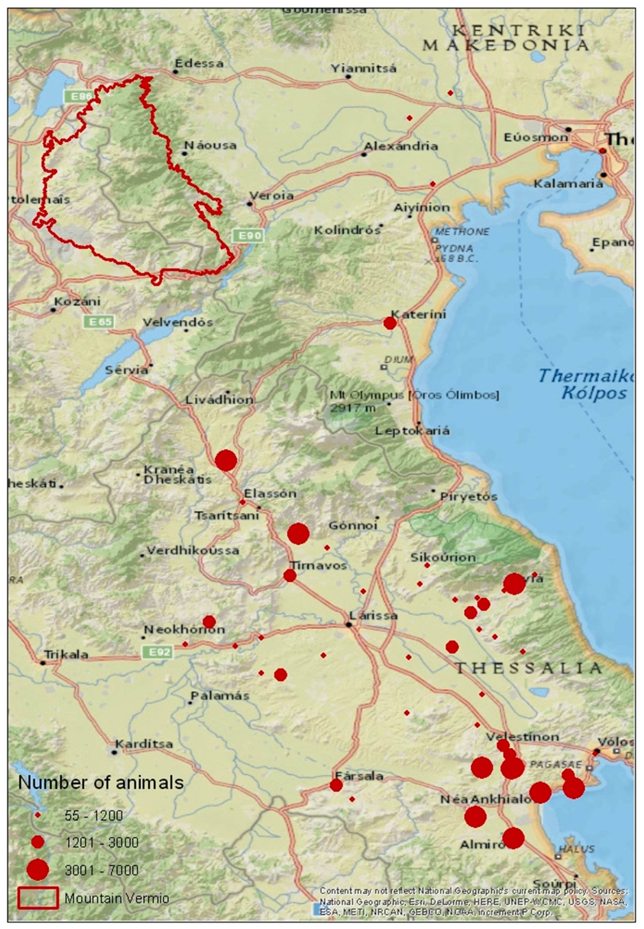
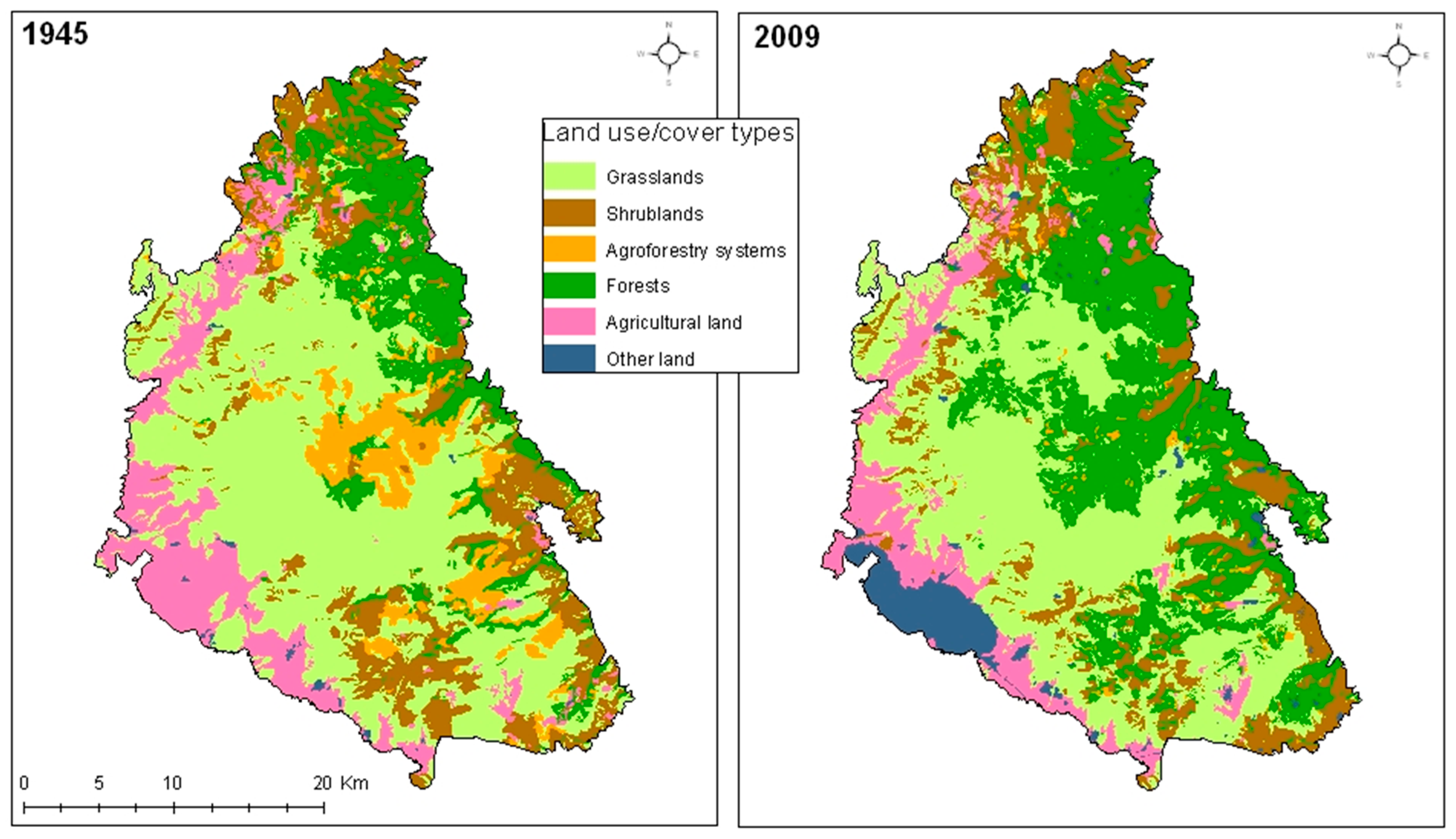
- The current study attempts to enhance the comprehension of the impact of transhumance on landscape pattern, provide basic information for assessing potential ecological threats and promote sustainable land-use planning using landscape metrics. Landscape metrics are used as a tool for the analysis and interpretation of land use/cover changes in Mount Vermio due to transhumance abandonment. To this end, the specific objectives of this study were to create land cover maps of Mount Vermio for 1945 and 2009.
- To estimate a set of landscape indices, which reveal qualitative and quantitative characteristics of the landscape, for 1945 and 2009.
- To assess and interpret the impacts of transhumance abandonment on the landscape, for the entire study area, as well as for two altitude zones separately.
2. Materials and Methods
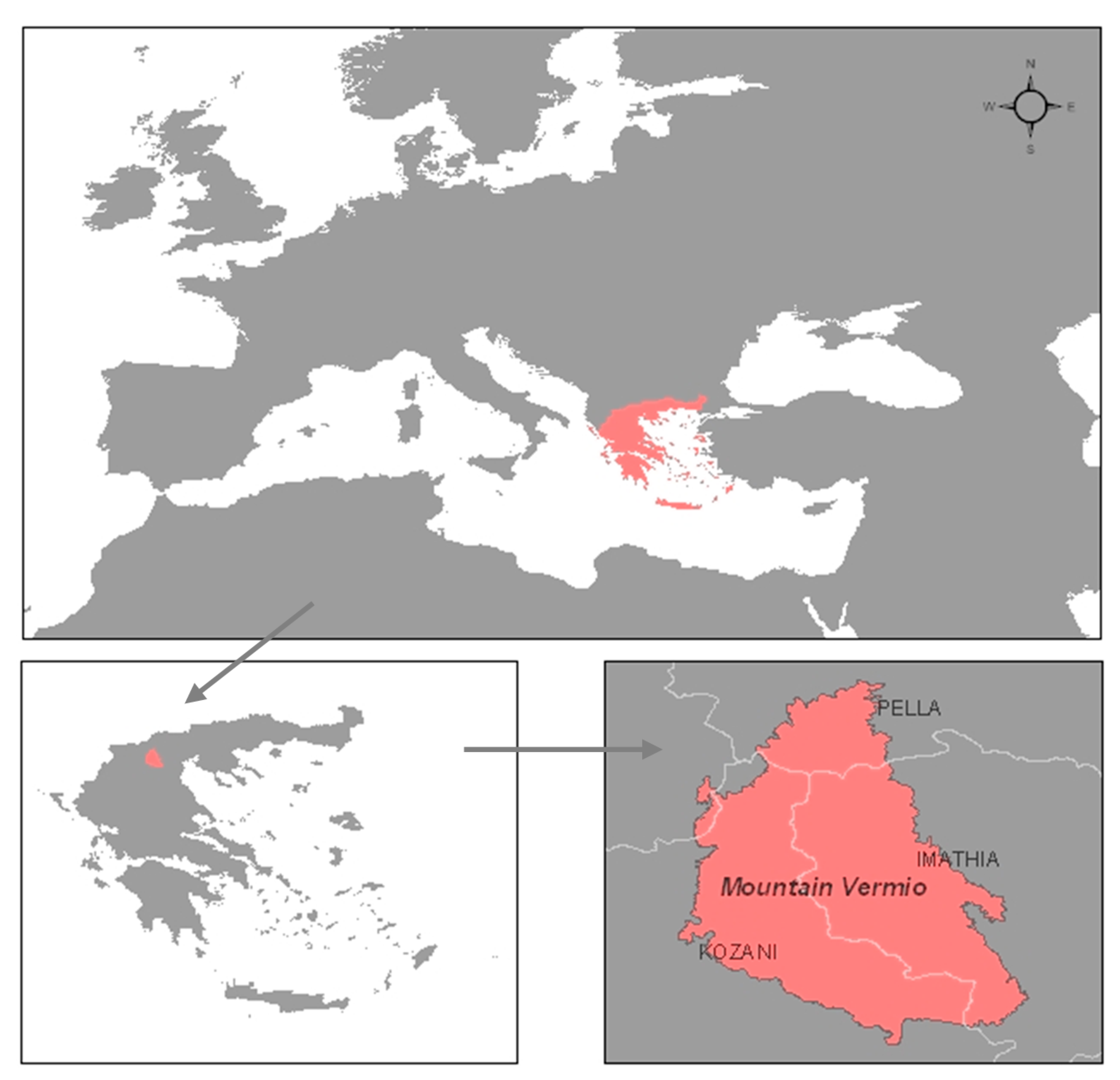
2.1. Study Area
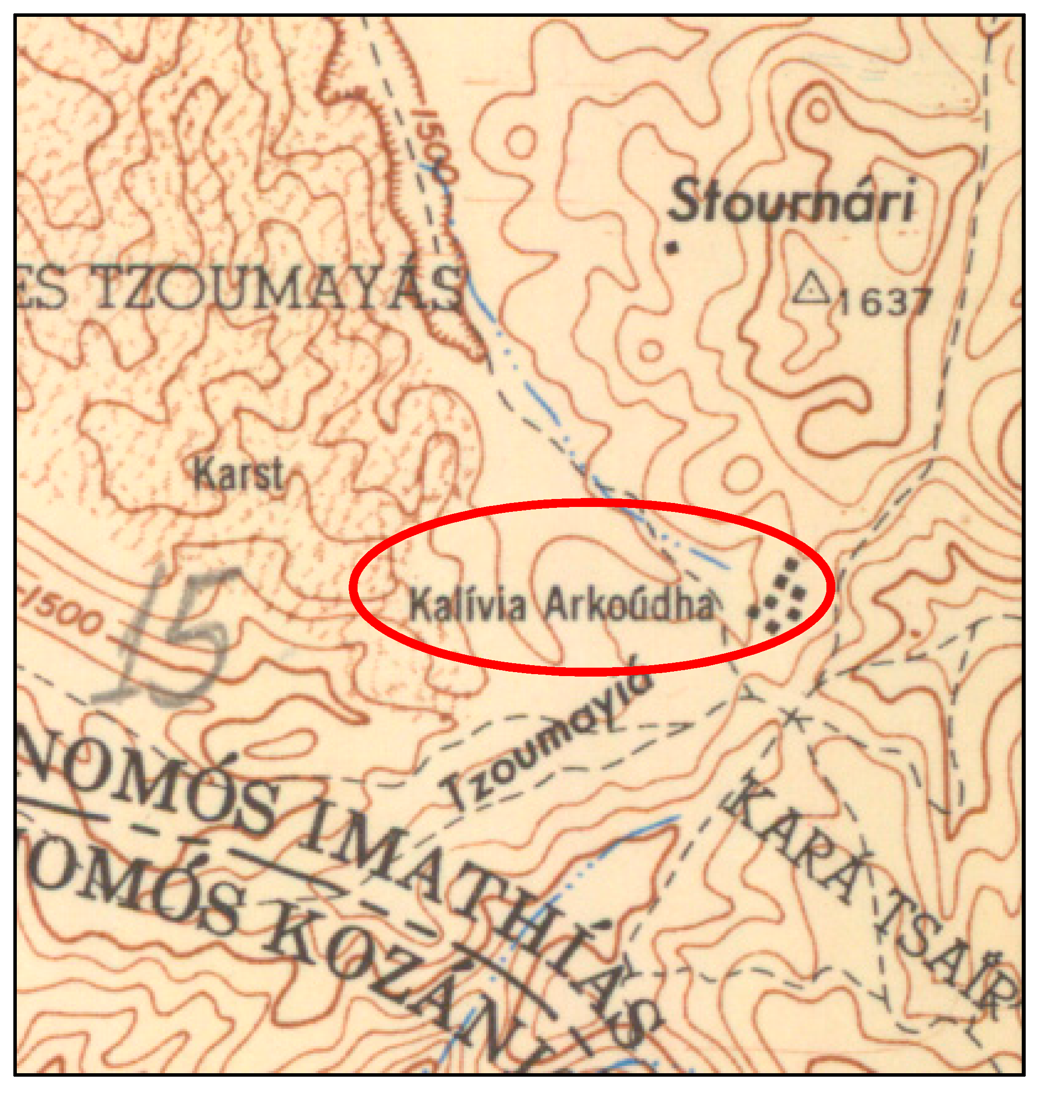
2.2. Methodology
| Land Use/Cover Class | Description |
|---|---|
| Grasslands | Areas dominated by herbaceous plants, with ground cover of woody vegetation less than 10% |
| Shrublands | Areas dominated by evergreen woody shrubs with sclerophyllous leaves |
| Agroforestry systems (Open grazed forest) | Areas dominate by herbaceous plants, with ground cover of woody vegetation between 10% and 40% |
| Forests | Areas with relative tree cover higher than 40% |
| Agricultural land | Fields with permanent or temporary crops |
| Other land | Areas with manmade features, including villages, mining fields, etc. |
| Landscape Metric | Abbreviation | Description | Unit | Land-scape Level | Class Level |
|---|---|---|---|---|---|
| Class Area | CA | Sum of areas of all patches | ha | - | ✓ |
| Number of Patches | NumP | Total number of patches | - | ✓ | ✓ |
| Mean Patch Size | MPS | Average patch size | ha | ✓ | ✓ |
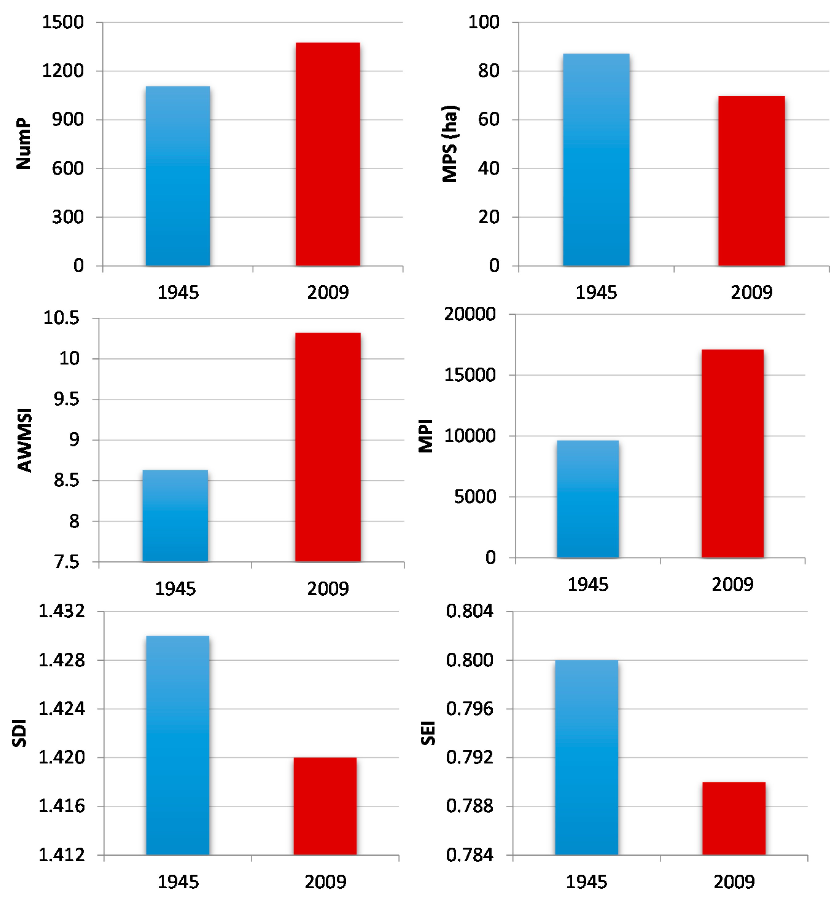
| (Area Weighted) Mean Shape Index | AWMSI | Measure of shape complexity. The index equals one when all patches are circular or square and increases as patch shape becomes more irregular | - | ✓ | - |
| Mean Proximity Index | MPI | Measure of degree of patch isolation and fragmentation within a specified radius. Integrates information on size and distance of like patches from a specified focal patch within a defined radius | - | ✓ | ✓ |
| Shannon’s Diversity Index | SDI | Measure of relative patch diversity. The index equals zero when there is only one patch in the landscape and increases as the number of patch types or proportional distribution of patch types increases | - | ✓ | - |
| Shannon’s Evenness Index | SEI | Measure of patch distribution and abundance. It is equal to zero when the observed patch distribution is low and approaches one when the distribution of patch types becomes more even | - | ✓ | - |
3. Results and Discussion
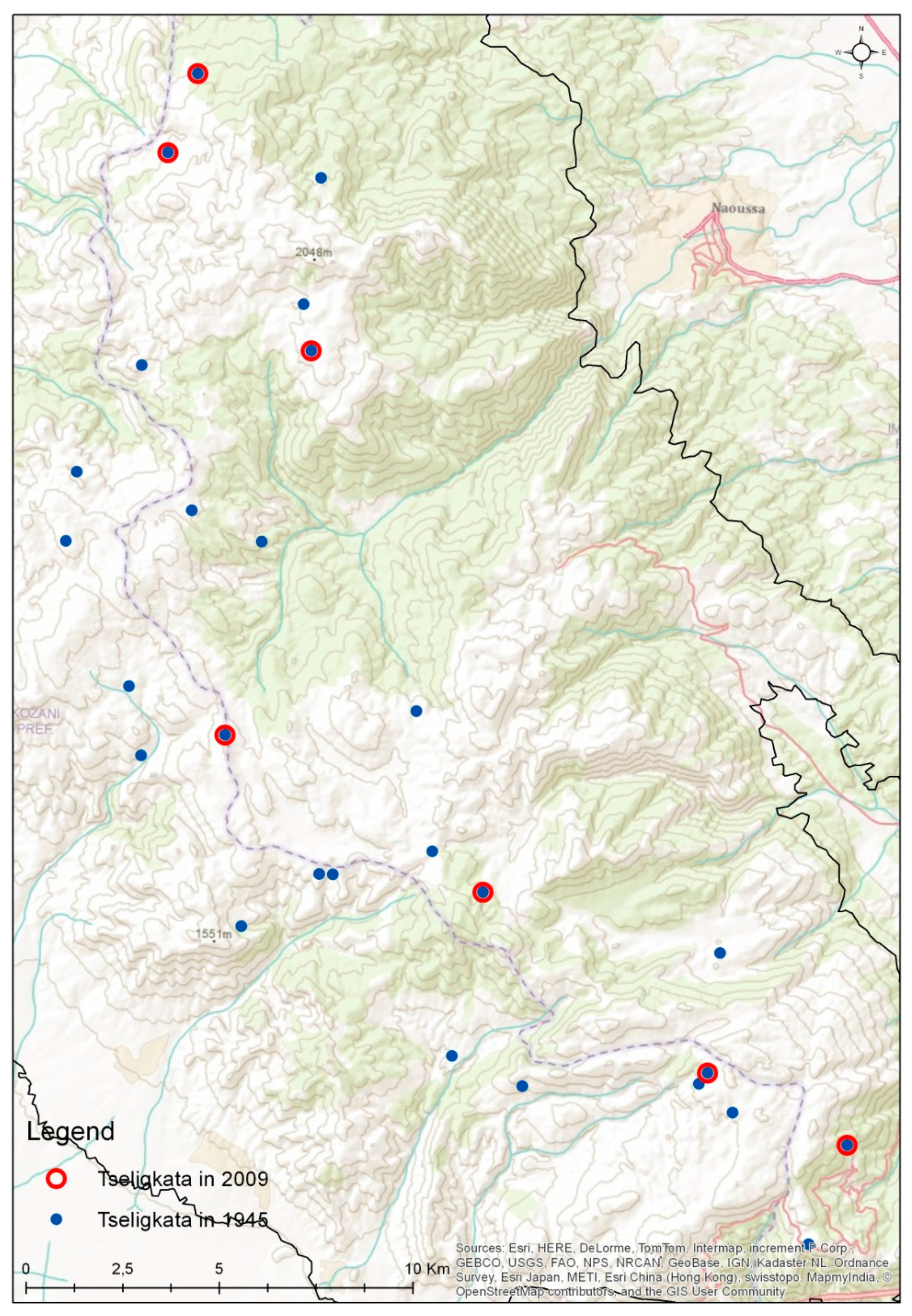
Landscape Change Analysis per Altitudinal Zone
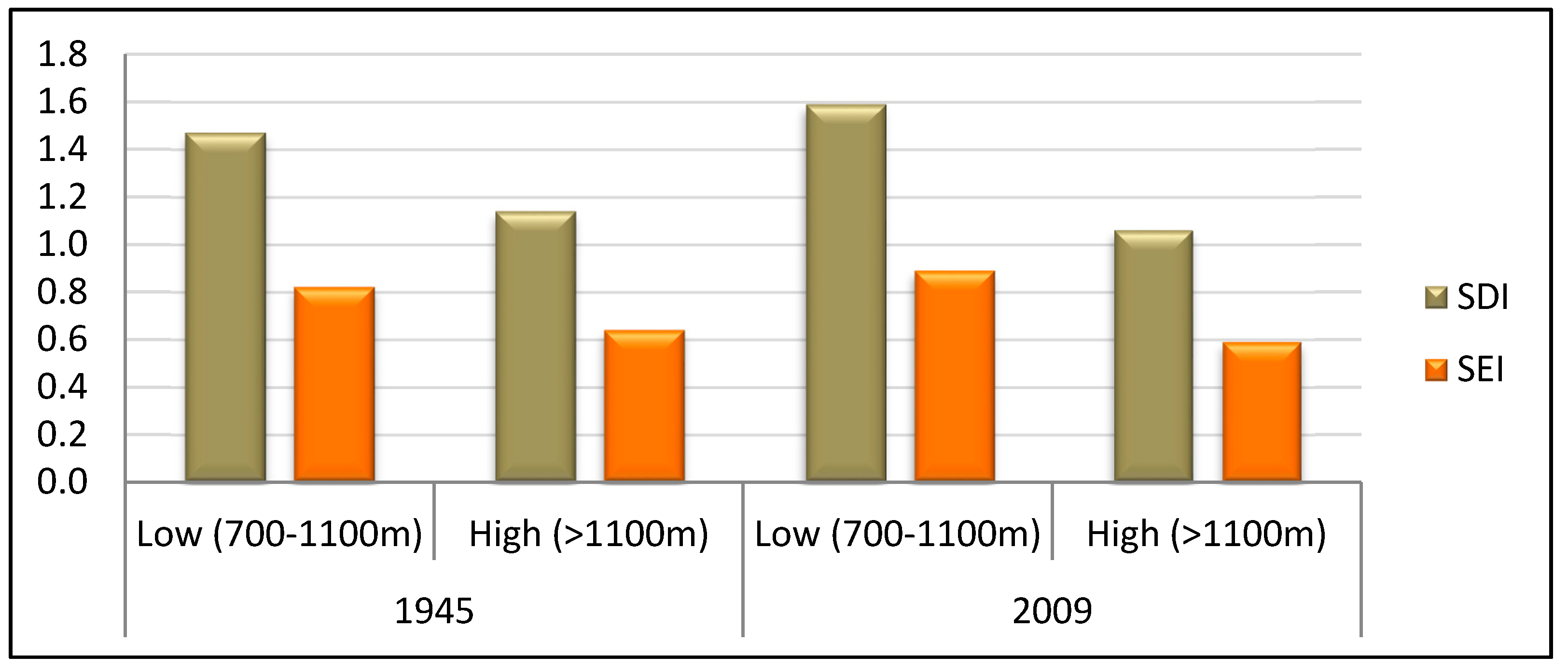
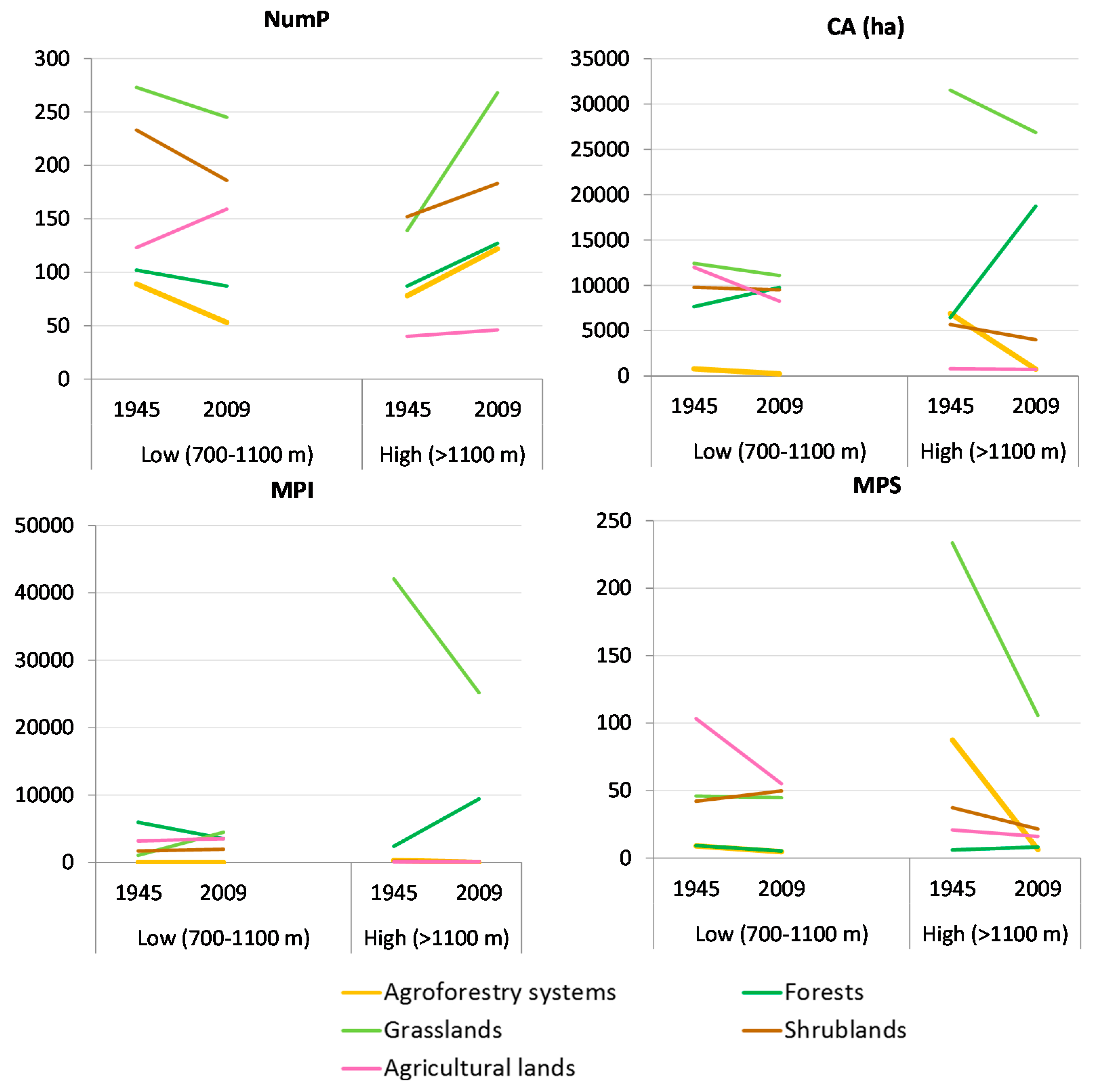
4. Conclusions
Acknowledgments
Author Contributions
Conflicts of Interest
References
- Ispikoudis, I.; Sioliou, M.; Papanastasis, V. Transhumance in greece: Past, present and future prospects. In Transhumance and Biodiversity in European Mountains; Bunce, R., Pérez-Soba, M., Jongman, R., Gómez Sal, A., Herzog, F., Austad, I., Eds.; IALE Publication: Wageningen, The Netherland, 2004; pp. 211–229. [Google Scholar]
- Oteros-Rozas, E.; Ontillera-Sánchez, R.; Sanosa, P.; Gómez-Baggethun, E.; Reyes-García, V.; González, J.A. Traditional Ecological Knowledge among Transhumant Pastoralists in Mediterranean Spain. 2013. Available online: http://dlc.dlib.indiana.edu/dlc/bitstream/handle/10535/9135/ES-2013-5597.pdf?sequence=1&isAllowed=y (accessed on 19 November 2015).
- Galanopoulos, K.; Abas, Z.; Laga, V.; Hatziminaoglou, I.; Boyazoglu, J. The technical efficiency of transhumance sheep and goat farms and the effect of eu subsidies: Do small farms benefit more than large farms? Small Rumin. Res. 2011, 100, 1–7. [Google Scholar] [CrossRef]
- Blondel, J. The ‘design’ of mediterranean landscapes: A millennial story of humans and ecological systems during the historic period. Hum. Ecol. 2006, 34, 713–729. [Google Scholar] [CrossRef]
- Oteros-Rozas, E.; González, J.A.; Martín-López, B.; López, C.A.; Montes, C. Ecosystem services and social-ecological resilience in transhumance cultural landscapes: Learning from the past, looking for a future. In Resilience and the Cultural Landscape. Understanding and Managing Change in Human-Shaped Environments; Plieninger, T., Bieling, C., Eds.; Cambridge University Press: Cambridge, UK, 2012; pp. 242–260. [Google Scholar]
- Pardini, A.; Nori, M. Agro-silvo-pastoral systems in italy: Integration and diversification. Pastoralism 2011. [Google Scholar] [CrossRef]
- Zervas, G. Quantifying and optimizing grazing regimes in greek mountain systems. J. Appl. Ecol. 1998, 35, 983–986. [Google Scholar] [CrossRef]
- Goltsiou, K. Research Theme: Routes of Transhumance—Research Report for Greece. 2011. Available online: http://www.prismanet.gr/canepal/en-10-research-topics/en-4-transhumance-routes/item/317-transhumance-routes-in-greece (accessed on 17 November 2015).
- Martín, P.G. The history and characteristics of the mesteña transhumance routes. In Transhumance and Biodiversity in European Mountains; Bunce, R., Pérez-Soba, M., Jongman, R., Gómez Sal, A., Herzog, F., Austad, I., Eds.; IALE Publication: Wageningen, The Netherland, 2004; pp. 255–258. [Google Scholar]
- Ntassiou, C.; Department of Civil Engineering, Aristotle Univesity of Thessaloniki, Thessaloniki, Greece. American Military Geographic Service (AMS). Topographic maps 1953–1955. Personal communication, 2015. [Google Scholar]
- Caballero, R.; Fernández-González, F.; Badia, R.P.; Molle, G.; Roggero, P.P.; Bagella, S.; D’Ottavio, P.; Papanastasis, V.P.; Fotiadis, G.; Sidiropoulou, A.; et al. Grazing systems and biodiversity in mediterranean areas: Spain, italy and greece. Pastos 2011. [Google Scholar] [CrossRef]
- Casasús, I.; Bernués, Α.; Sanz, Α.; Riedel, J.; Revilla, R. Utilization of mediterranean forest pastures by suckler cows: Animal performance and impact on vegetation dynamics. In Animal Production and Natural Resources Utilisation in the Mediterranean Mountain Areas; Georgoudis, A., Rosati, A., Mosconi, C., Eds.; EAAP Scientific Series: Ioannina, Greece, 2005; Volume 115, pp. 82–88. [Google Scholar]
- Kourakly, P.; Sidiropoulou, A.; Kostopoulou, P.; Ispikoudis, I. Impacts of livestock husbandry on the landscape. In Animal Production and Natural Resources Utilization in the Mediterranean Mountain Areas; Georgoudis, A., Rosati, A., Mosconi, C., Eds.; EAAP Scientific Series: Ioannina, Greece, 2005; Volume 115, pp. 220–223. [Google Scholar]
- Bailey, D.; Dumont, B.; Wallis De Vries, M.F. Utilization of heterogeneous grasslands by domestic herbivores: Theory to management. Ann. Zootech. 1998, 47, 321–333. [Google Scholar] [CrossRef]
- Sternberg, M.; Gutman, M.; Perevolotsky, A.; Ungar, E.D.; Kigel, J. Vegetation response to grazing management in a mediterranean herbaceous community: A functional group approach. J. Appl. Ecol. 2000, 37, 224–237. [Google Scholar] [CrossRef]
- Vrahnakis, M.; Kyriazopoulos, A.; Fotiadis, G.; Sidiropoulou, A.; Dionisopoulou, Α. Changes in components of floristic diversity in three adjacent rangeland types. Grassl. Sci. Eur. 2005, 10, 144–148. [Google Scholar]
- Karatassiou, M.; Parissi, Z.; Sklavou, P.; Ispikoudis, S. The impact of transhumant livestock system on the diversity of two mountainous grasslands in northern Greece. Options Méditerr. Ser. 2014, 109, 499–503. [Google Scholar]
- Adler, P.Β.; Raff, D.Α.; Lauenroth, W.Κ. The effect of grazing on the spatial heterogeneity of vegetation. Oecologia 2001, 128, 465–479. [Google Scholar] [CrossRef]
- Perevolotsky, A. Integrating landscape ecology in the conservation of mediterranean ecosystems: The israeli experience. Isr. J. Plant Sci. 2005, 53, 203–213. [Google Scholar] [CrossRef]
- Coppolillo, P.B. Central-place analysis and modeling of landscape-scale resource use in an east african agropastoral system. Landsc. Ecol. 2001, 16, 205–219. [Google Scholar] [CrossRef]
- Sklavou, P.; Karatassiou, Μ.; Sidiropoulou, Α. The role of transhumance in the evolution of vegetation and landscape: A case study in northern Greece (Vermio mountain). In Rangelands-Livestock: Research and Development; Kuriazopoulos, Α., Karatassiou, Μ., Sklavou, P., Chouvardas, D., Eds.; Hellenic Rangeland Society, M.E.E.C.C.: Thessaloniki, Greece, 2014; pp. 59–64. (In Greek) [Google Scholar]
- Ispikoudis, I.; Lyrintzis, G.; Kyriakakis, S. Impact of human activities on mediterranean landscapes in western crete. Landsc. Urban Plan. 1993, 24, 259–271. [Google Scholar] [CrossRef]
- Noy-Meir, I. Interactive effects of fire and grazing on structure and diversity of mediterranean grasslands. J. Veg. Sci. 1995, 6, 701–710. [Google Scholar] [CrossRef]
- Riecken, U.; Finck, P.; Schröder, E. Significance of pasture landscapes for nature conservation and extensive agriculture. In Pasture Landscapes and Nature Conservation; Redecker, B., Härdtle, W., Finck, P., Riecken, U., Schröder, E., Eds.; Springer: Heidelberg, Germany, 2002; pp. 423–435. [Google Scholar]
- Olsson, E.G.; Austrheim, G.; Grenne, S. Landscape change patterns in mountains, land use and environmental diversity, mid-norway 1960–1993. Landsc. Ecol. 2000, 15, 155–170. [Google Scholar] [CrossRef]
- Halstead, P. Pastoralism or household herding? Problems of scale and specialization in early greek animal husbandry. World Archaeol. 1996, 28, 20–42. [Google Scholar] [CrossRef]
- Papanastasis, V.P.; Arianoutsou, M.; Papanastasis, K. Environmental conservation in classical greece. J. Biol. Res. 2010, 14, 123–135. [Google Scholar]
- Hadjigeorgiou, I. Past, present and future of pastoralism in greece. Pastoralism 2011. [Google Scholar] [CrossRef]
- Höeg, C. Les Saracatsans, Une Tribu Nomade Grecque; Edouard Champion: Paris, France, 1925. (In French) [Google Scholar]
- Cusumano, C. Greece, a Love Story; Seal Press: Berkeley, CA, USA, 2007. [Google Scholar]
- Kavvadias, G. Pasteurs-Nomades Mediterranéens: Les Saracatsans de Grèce; Gauthier-Villars: Paris, France, 1965. (In French) [Google Scholar]
- Katsaros, Ν. Ta Sarakatsanika Tseligkata tou Vermiou; Syllogos Sarakatsanaion Perfecture Imathias “Oi Stavraetoi”: Alexandria Imathias, Greece, 2009. (In Greek) [Google Scholar]
- Chatzimichali, Α. Sarakatsanoi, 2nd ed.; Angeliki Chatzimichali Foundation: Athina, Greece, 2007. (In Greek) [Google Scholar]
- Sirkou, D.; Skarlatou, A. Sarakatsani of epirus. In Range Science on the Threshold of 21th Century; Papachristou, T., Dini-Papanastasi, O., Eds.; Hellenic Rangeland Society: Ioannina, Greece, 2001; pp. 65–69. (In Greek) [Google Scholar]
- Dong, S.; Wen, L.; Liu, S.; Zhang, X.; Lassoie, J.; Yi, S. Vulnerability of worldwide pastoralism to global changes and interdisciplinary strategies for sustainable pastoralism. 2011. Available online: http://www.ecologyandsociety.org/vol16/iss2/art10/ (accessed on 17 November 2015).
- Kavvadias, G. Sarakatsanoi: A Greek Pastoral Society; Lousi Mpratzioti Publishing: Athens, Greece, 1991. (In Greek) [Google Scholar]
- Leitão, A.B.; Ahern, J. Applying landscape ecological concepts and metrics in sustainable landscape planning. Landsc. Urban Plan. 2002, 59, 65–93. [Google Scholar] [CrossRef]
- Tucker, G.M.; Graham, M.; Evans, M.I. Habitats for Birds in Europe: A Conservation Strategy for the Wider Environment; BirdLife International: Cambridge, UK, 1997. [Google Scholar]
- Gillanders, S.N.; Coops, N.C.; Wulder, M.A.; Gergel, S.E.; Nelson, T. Multitemporal remote sensing of landscape dynamics and pattern change: Describing natural and anthropogenic trends. Prog. Phys. Geogr. 2008, 32, 503–528. [Google Scholar] [CrossRef]
- Bankov, N. Dynamics of land cover/use changes in relation to socio-economic condition in the psilorites mountain of crete, greece. Master’s Thesis, Mediterranean Agronomic Institute of Chania, Chania, Greece, 1998. [Google Scholar]
- Farina, A. Principles and Methods in Landscape Ecology; Springer: The Netherlands, UK, 1998. [Google Scholar]
- Turner, M.G. Landscape ecology: The effect of pattern on process. Annu. Rev. Ecol. Syst. 1989, 20, 171–197. [Google Scholar] [CrossRef]
- Wu, J.; Hobbs, R. Key issues and research priorities in landscape ecology: An idiosyncratic synthesis. Landsc. Ecol. 2002, 17, 355–365. [Google Scholar] [CrossRef]
- O’Neill, R.V.; Milne, B.T.; Turner, M.G.; Gardner, R.H. Resource utilization scales and landscape pattern. Landsc. Ecol. 1988, 2, 63–69. [Google Scholar] [CrossRef]
- Turner, M.G.; Gardner, R.H. Quantitative Methods in Landscape Ecology; Springer-Verlag: New York, NY, USA, 1991. [Google Scholar]
- McGarigal, K.; Marks, B.J. Fragstat: Spatial Pattern Analysis Program for Quantifying Landscape Structure. 1995. Available online: http://andrewsforest.oregonstate.edu/pubs/pdf/pub1538.pdf (accessed on 17 November 2015).
- Wang, A.H.; Zhang, S.Q.; Zhang, B. A study on the change of spatial pattern of wetland in the Sanjiang plain. Acta Ecol. Sin. 2003, 23, 237–243. [Google Scholar]
- Sidiropoulou, A. Analysis and evaluation of agroforestry systems using landscape indicators. Ph.D. Thesis, Aristotle University of Thessaloniki, Thessaloniki, Greece, October 2011. [Google Scholar]
- Corry, R.C.; Lafortezza, R. Sensitivity of landscape measurements to changing grain size for fine-scale design and management. Landsc. Ecol. Eng. 2007, 3, 47–53. [Google Scholar] [CrossRef]
- Plexida, S.G.; Sfougaris, A.I.; Ispikoudis, I.P.; Papanastasis, V.P. Selecting landscape metrics as indicators of spatial heterogeneity-a comparison among greek landscapes. Int. J. Appl. Earth Obs. Geoinf. 2014, 26, 26–35. [Google Scholar] [CrossRef]
- Sidiropoulou, Α.; Mantzanas, K.; Vrahnakis, M.; Ispikoudis, I. Inventory and landscape structure analysis of agrosilvopastoral systems in florina regional unit. In Dry Grasslands of Europe: Grazing and Ecosystem Services; Vrahnakis, M., Kyriazopoulos, A.P., Chouvardas, D., Fotiadis, G., Eds.; HERPAS: Thessaloniki, Greece, 2013; pp. 318–324. [Google Scholar]
- Crews-Meyer, K. Characterizing landscape dynamism using paneled-pattern metrics. Photogramm. Eng. Remote Sens. 2002, 68, 1031–1040. [Google Scholar]
- Ricca, N.; Guagliardi, I. Multi-temporal dynamics of land use patterns in a site of community importance in southern Italy. Appl. Ecol. Environ. Res. 2015, 13, 677–691. [Google Scholar]
- European Commission (EC). Statistical Information Needed for the Indicators to Monitor the Integration of Environmental Concerns into the Common Agricultural Policy. 2001. Available online: http://eur-lex.europa.eu/legal-content/EN/TXT/?uri=celex:52006DC0508 (accessed on 17 November 2015).
- Lausch, A.; Herzog, F. Applicability of landscape metrics for the monitoring of landscape change: Issues of scale, resolution and interpretability. Ecol. Indic. 2002, 2, 3–15. [Google Scholar] [CrossRef]
- O’Neill, R.V.; Hunsaker, C.T.; Jones, K.B.; Riitters, K.H.; Wickham, J.D.; Schwartz, P.M.; Goodman, I.A.; Jackson, B.L.; Baillargeon, W.S. Monitoring environmental quality at the landscape scale. Bioscience 1997, 47, 513–519. [Google Scholar] [CrossRef]
- Wascher, D.M.; Pérez-Soba, M. Learning from European Transfrontier Landscapes. 2004. Available online: http://www.landscape-europe.net/images/files/whole3web%20II.pdf (accessed on 17 November 2015).
- Zorn, P.; Stephenson, W.; Grigoriev, P. An ecosystem management program and assessment process for Ontario national parks. Conserv. Biol. 2001, 15, 353–362. [Google Scholar] [CrossRef]
- Haines-Young, R.; Chopping, M. Quantifying landscape structure: A review of landscape indices and their application to forested landscapes. Prog. Phys. Geogr. 1996, 20, 418–445. [Google Scholar] [CrossRef]
- Forman, R.T.T.; Godron, M. Landscape Ecology; John Wiley & sons: Hoboken, NJ, USA, 1986. [Google Scholar]
- Collinge, S.K. Ecological consequences of habitat fragmentation: Implications for landscape architecture and planning. Landsc. Urban Plan. 1996, 36, 59–77. [Google Scholar] [CrossRef]
- Gustafson, E.J. Quantifying landscape spatial pattern: What is the state of the art? Ecosystems 1998, 1, 143–156. [Google Scholar] [CrossRef]
- Meini, M.; Adducchio, D.; Ciliberti, D.; Di Felice, G. Landscape conservation and valorization by satellite imagery and historic maps. The case of italian transhumance routes. Eur. J. Remote Sens. 2014, 47, 375–387. [Google Scholar] [CrossRef]
- Sarno, E. Historical Maps and Gis Environment as Integrated Methodology to Rediscovery of Cattle-Track Landscapes. A Case Study. 2014. Available online: https://www.academia.edu/8735813/HISTORICAL_MAPS_AND_GIS_ENVIRONMENT_AS_INTEGRATED_METHODOLOGY_TO_REDISCOVERY_OF_CATTLE-TRACK_LANDSCAPES._A_CASE_STUDY (accessed on 17 November 2015).
- Russo, P.; Riguccio, L.; Carullo, L.; Tomaselli, G. Parametric analysis of the changes a landscape previously used for transhumance in a nature reserve in sicily. Nat. Resour. 2014, 5, 213–224. [Google Scholar] [CrossRef] [Green Version]
- Olea, P.P.; Mateo-Tomás, P. The role of traditional farming practices in ecosystem conservation: The case of transhumance and vultures. Biol. Conserv. 2009, 142, 1844–1853. [Google Scholar] [CrossRef]
- Mitka, A.; Chouvardas, D.; Ispikoudis, I. Temporal landscape changes (1963–1998) at the region of “kopatsari” in the prefecture of grevena. In Range Science and Life Quality; Sidiropoulou, A., Mantzanas, K., Ispikoudis, I., Eds.; Hellenic Rangeland Society: Xanthi, Greece, 2010; pp. 97–102. (In Greek) [Google Scholar]
- Chochliouros, S. Floristic and phytosociological research of mount vermion: An ecological approach. Ph.D. Thesis, University of Patras, Patra, Greece, June 2005. [Google Scholar]
- Zianis, D.; Mencuccini, M. Aboveground biomass relationships for beech (fagus moesiaca cz.) trees in vermio mountain, northern greece, and generalised equations for fagus sp. Ann. For. Sci. 2003, 60, 439–448. [Google Scholar] [CrossRef]
- National Cadastre and Mapping Agency S.A. Aerial Photographs; NCMA S.A.: Athens, Greece, 1945. [Google Scholar]
- NASA LP DAAC, U.S. Geological Survey. ASTER Global Digital Elevation Model V001, Version: V001. Sioux Falls, South Dakota, USA. 2009. Available online: https://lpdaac.usgs.gov/ (accessed on 20 November 2015). [Google Scholar]
- ESRI. Arcmap™: Release 10.1; Environmental Systems Resource Institute: Redlands, CA, USA, 2011. [Google Scholar]
- Geri, F.; Amici, V.; Rocchini, D. Human activity impact on the heterogeneity of a mediterranean landscape. Appl. Geogr. 2010, 30, 370–379. [Google Scholar] [CrossRef]
- Herzog, F.; Lausch, A.; Muller, E.; Thulke, H.-H.; Steinhardt, U.T.A.; Lehmann, S. Landscape metrics for assessment of landscape destruction and rehabilitation. Environ. Manag. 2001, 27, 91–107. [Google Scholar] [CrossRef] [PubMed]
- John, R.; Chen, J.; Lu, N.; Wilske, B. Land cover/land use change in semi-arid Inner Mongolia: 1992–2004. Environ. Res. Lett. 2009, 4. Article 4. [Google Scholar] [CrossRef]
- Elkie, P.C.; Rempel, R.S.; Carr, A. Patch Analyst User’s Manual: A Tool for Quantifying Landscape Structure; Ontario Ministry of Natural Resources, Boreal Science, Northwest Science & Technology: Thunder Bay, ON, Canada, 1999.
- Dunn, C.P.; Sharpe, D.M.; Guntenspergen, G.R.; Steams, F.; Yang, Z. Methods for analyzing temporal changes in landscape pattern. In Quantitative Methods in Landscape Ecology, the Analysis and Interpretation of Landscape Heterogeneity; Turner, M.G., Gardner, R.H., Eds.; Springer-Verlag: New York, NY, USA, 1991; Volume 82, pp. 173–198. [Google Scholar]
- Moreira, F.; Rego, F.; Ferreira, P. Temporal (1958–1995) pattern of change in a cultural landscape of northwestern Portugal: Implications for fire occurrence. Landsc. Ecol. 2001, 16, 557–567. [Google Scholar] [CrossRef]
- Turner, M.; Ruscher, C.L. Changes in landscape patterns in Georgia, USA. Landsc. Ecol. 1988, 1, 241–251. [Google Scholar] [CrossRef]
- Atauri, J.A.; De Lucio, J.V. The role of landscape structure in species richness distribution of birds, amphibians, reptiles and lepidopterans in mediterranean landscapes. Landsc. Ecol. 2001, 16, 147–159. [Google Scholar] [CrossRef]
- McGarigal, K.; McComb, W.C. Relationships between landscape structure and breeding birds in the oregon coast range. Ecol. Monogr. 1995, 65, 235–260. [Google Scholar] [CrossRef]
- Botequilha Leitão, A.; Miller, J.; Ahern, K.; McGarigal, K. Measuring Landscapes: A Planner’s Handbook; Island Press: Washington, DC, USA, 2006. [Google Scholar]
- Franklin, J.; Forman, R.T. Creating landscape patterns by forest cutting: Ecological consequences and principles. Landsc. Ecol. 1987, 1, 5–18. [Google Scholar] [CrossRef]
- Bender, D.J.; Contreras, T.A.; Fahrig, L. Habitat loss and population decline: A meta-analysis of patch size effect. Ecology 1998, 79, 517–533. [Google Scholar] [CrossRef]
- Gustafson, E.; Parker, G. Relationships between landcover proportion and indices of landscape spatial pattern. Landsc. Ecol. 1992, 7, 101–110. [Google Scholar] [CrossRef]
- Haken, H. Information and Self-Organization: A Macroscopic Approach to Complex Systems (Springer Series in Synergetics); Springer-Verlag NY: New York, USA, 2006. [Google Scholar]
- Prigogine, I. The End of Certainty: Time, Chaos, and the New Laws of Nature; Free Press: New York, NY, USA, 1997. [Google Scholar]
- Cowling, R.M.; Rundel, P.W.; Lamont, B.B.; Arroyo, M.K.; Arianoutsou, M. Plant diversity in mediterranean-climate regions. Trends Ecol. Evol. 1996, 11, 362–366. [Google Scholar] [CrossRef]
- Naveh, Z.; Whittaker, R.H. Structural and floristic diversity of shrublands and woodlands in northern Israel and other mediterranean areas. Vegetatio 1980, 41, 171–190. [Google Scholar] [CrossRef]
- Noy-Meir, I. Effects of grazing on mediterranean grasslands: The community level. In Ecological Basis of Livestock Grazing in Mediterranean Ecosystems, Proceeding of the International Occasional Symposium of EGF 4, Thessaloniki, Greece, 23–25 October 1997; Papanastasis, V.P., Peter, D., Eds.; pp. 27–39.
- Payment and Control Agency for Guidance and Guarantee Community Aid (PCAGGCA). Registry of Farms and Farmers; Ministry of Rural Development and Food: Athens, Greece, 2011.
- Oteros-Rozas, E.; Martín-López, B.; López, C.A.; Palomo, I.; González, J.A. Envisioning the future of transhumant pastoralism through participatory scenario planning: A case study in Spain. Rangel. J. 2013, 35, 251–272. [Google Scholar] [CrossRef]
- Ainalis, A.; Meliadis, I.; Tsiouvaras, K.; Ainali, K.; Platis, D.; Platis, P. Multitemporal land use οchanges in a region of Pindus mountain, central Greece. Agric. For. Fish. 2015, 4, 18–23. [Google Scholar]
- Davies, J.; Hatfield, R. The economics of mobile pastoralism: A global summary. Nomadic Peoples 2007, 11, 91–116. [Google Scholar] [CrossRef]
- Lasanta-Martínez, T.; Vicente-Serrano, S.M.; Cuadrat-Prats, J.M. Mountain mediterranean landscape evolution caused by the abandonment of traditional primary activities: A study of the Spanish central pyrenees. Appl. Geogr. 2005, 25, 47–65. [Google Scholar] [CrossRef]
- Agnoletti, M. The degradation of traditional landscape in a mountain area of tuscany during the 19th and 20th centuries: Implications for biodiversity and sustainable management. For. Ecol. Manag. 2007, 249, 5–17. [Google Scholar] [CrossRef]
- Sidiropoulou, A.; Ispikoudis, I. Ancient trees as indicators of agroforestry systems-three case studies from northern Greece. In Woodland Cultures in Time and Space-Tales from the Past, Messages for the Future; Saratsi, E., Bόrgi, M., Johann, E., Kirby, K., Moreno, D., Watkins, C., Eds.; Embryo Publications: Athens, Greece, 2009; pp. 138–144. [Google Scholar]
- Vrahnakis, M.S.; Fotiadis, G.; Pantera, A.; Papadopoulos, A.; Papanastasis, V.P. Floristic diversity of valonia oak silvopastoral woodlands in Greece. Agrofor. Syst. 2014, 88, 877–893. [Google Scholar] [CrossRef]
- Bunce, R.; Pérez-Soba, M.; Jongman, R.; Gómez Sal, A.; Herzog, F.; Austad, I. Transhumance and Biodiversity in European Mountains. 2004. Available online: http://www.jbjordal.no/publikasjoner/Transhumance.pdf (accessed on 17 November 2015).
- Antrop, M. Landscape change and the urbanization process in Europe. Landsc. Urban Plan. 2004, 67, 9–26. [Google Scholar] [CrossRef]
- Romero-Calcerrada, R.; Perry, G.L.W. The role of land abandonment in landscape dynamics in the spa ‘encinares del rı́o alberche y cofio, central Spain, 1984–1999. Landsc. Urban Plan. 2004, 66, 217–232. [Google Scholar] [CrossRef]
© 2015 by the authors; licensee MDPI, Basel, Switzerland. This article is an open access article distributed under the terms and conditions of the Creative Commons Attribution license (http://creativecommons.org/licenses/by/4.0/).
Share and Cite
Sidiropoulou, A.; Karatassiou, M.; Galidaki, G.; Sklavou, P. Landscape Pattern Changes in Response to Transhumance Abandonment on Mountain Vermio (North Greece). Sustainability 2015, 7, 15652-15673. https://doi.org/10.3390/su71115652
Sidiropoulou A, Karatassiou M, Galidaki G, Sklavou P. Landscape Pattern Changes in Response to Transhumance Abandonment on Mountain Vermio (North Greece). Sustainability. 2015; 7(11):15652-15673. https://doi.org/10.3390/su71115652
Chicago/Turabian StyleSidiropoulou, Anna, Maria Karatassiou, Georgia Galidaki, and Paraskevi Sklavou. 2015. "Landscape Pattern Changes in Response to Transhumance Abandonment on Mountain Vermio (North Greece)" Sustainability 7, no. 11: 15652-15673. https://doi.org/10.3390/su71115652
APA StyleSidiropoulou, A., Karatassiou, M., Galidaki, G., & Sklavou, P. (2015). Landscape Pattern Changes in Response to Transhumance Abandonment on Mountain Vermio (North Greece). Sustainability, 7(11), 15652-15673. https://doi.org/10.3390/su71115652


