1. Introduction
Farmland is one of the most important non-renewable resources in contemporary China [
1], and farmland per capita is a mere 0.09 ha, which is over 50% lower than the world average of 0.236 ha [
2,
3]. Furthermore, approximately 4000 km
2 of farmland have disappeared every year since the late 1990s in China [
4], while the global loss estimated per year is about 20,000 km
2. Thus farmland preservation affects the overall interests of China, and even the whole world. Given the declines in the area devoted to farmland, it is no surprise that scholars have predicted that China would soon need to resort to grain imports on a scale massive enough to cause severe disruptions in world markets [
5,
6].
The Chinese central government has devoted considerable attention to the sharp decrease in farmland and enacted numerous laws and regulations concerning agriculture, commerce and finance to curb indiscriminate occupancy of cultivated land, the approval of land requisitions in violation of the law and the waste of land, and even announced that “holding extremely dear and making rational use of every single inch of land and earnestly protecting farmland” would be the basic state policy [
7,
8,
9].
Land use planning is an important measure to pursue this aim. The core of land use planning is the arrangement of the uses of agricultural and urban land [
10,
11,
12,
13,
14,
15]. In most developed countries, it is common to protect farmland through land use planning [
16,
17]. In Japan, land use master plans were developed using four different zones (urbanization promotion zones, urbanization control zones, agricultural land zones and agricultural promotion zones) based on multiple levels of legislation to protect farmland [
18]. In the US, both agricultural zoning and non-zoning techniques (such as land acquisition programs and taxation programs) have been employed to persevere agricultural lands [
16]. In the Netherlands, although no special farmland preservation policy exists, quantity targets or limits on farmland conversion exist, comprehensive land use plans already indicate the land use of every plot, and no farmland conversion can take place if it violates the plan [
19].
China first attempted to use land use planning for farmland preservation in 1987. Although land use planning has a relatively brief history in China compared to Western European and North American countries, China has continued to explore methods and techniques for farmland preservation. The goal of the first round of land use planning (completed in 1987 with an implementation period from 1985 to 2000) is to resolve the supply and demand conflict between farmland and construction land, but these efforts failed to achieve success [
20,
21]. In the second round of land use planning (completed in 1999 with an implementation period from 1997 to 2010), several techniques, such as land use zones and a land use quota system were devised to protect farmland. This process also led to the proposal of a policy of “maintaining a dynamic farmland balance”. This process marked the first successful attempt to use land use planning for farmland preservation. During the third round land of use planning (which began in 2005 and was completed in 2010 with an implementation period from 2006 to 2020), the Chinese Land Resource Ministry (MLRC) released more detailed guidelines regarding farmland preservation, especially concerning spatial content. In general, preservation measures have gradually matured and improved over time.
This paper focuses on farmland preservation planning measures, in an attempt to illustrate efforts to protect farmland using planning techniques in contemporary China. Dachang County, a typical rural county bordering Beijing, was selected as the study area. Previous farmland preservation planning measures were briefly reviewed. The relationship between changes in farmland use and socio-economic development were analyzed. The disadvantages of prior planning measures were illustrated in detail. Then, three measures for farmland preservation developed in the third phase of land use planning were illustrated and discussed. During the research process, two field surveys were conducted in November 2010 and July 2011. Several discussions were held with the local Land Resources Bureau staff, township business owners and farmers. All of the findings would be useful for the researchers to understand China’s land use administration system, allowing this study to be used as a reference in the literature on land resource management and planning.
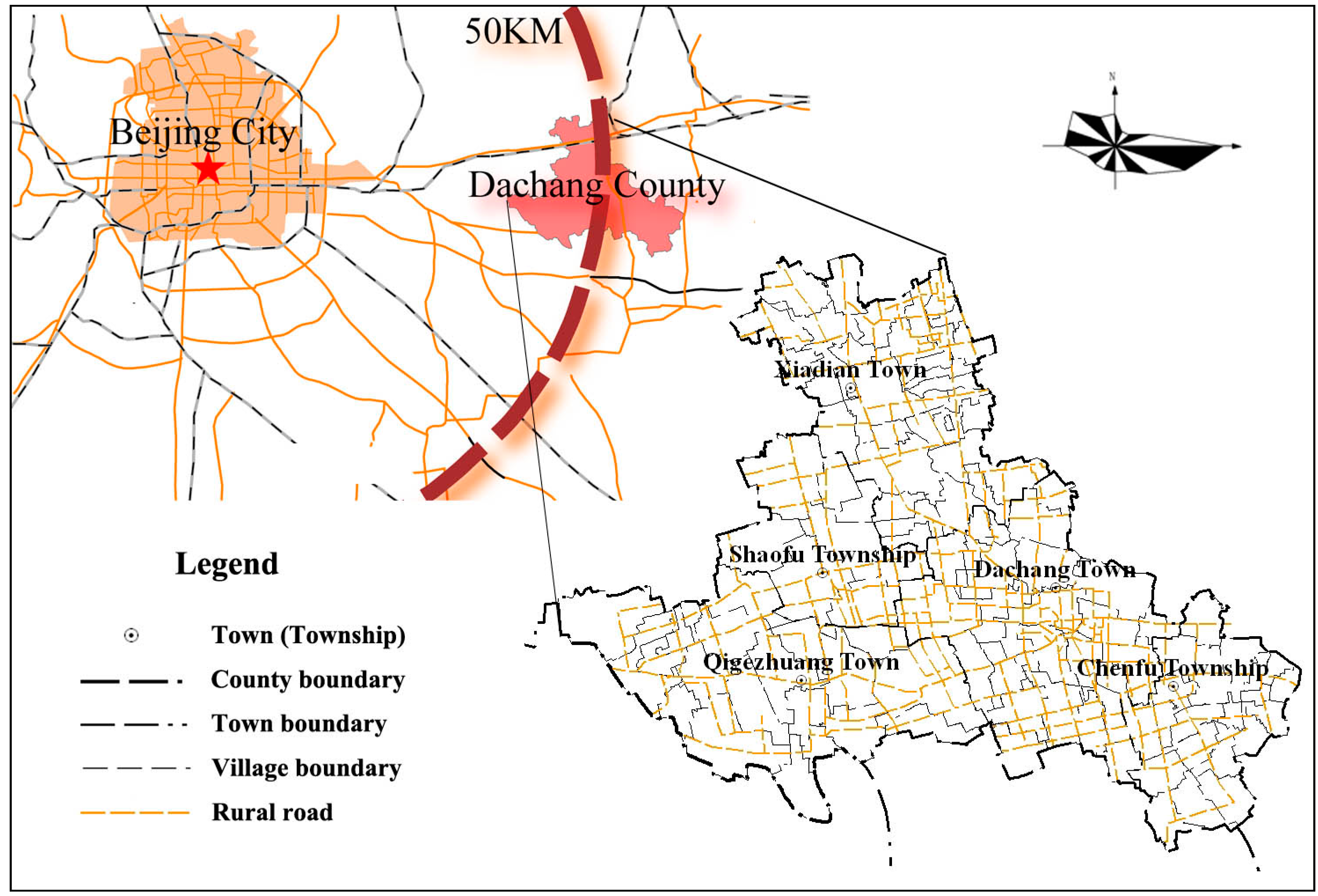
2. Study Area
The study area, Dachang Hui Autonomous County (hereafter referred to as Dachang County) is a typical agricultural county located in Northern China (ranging from 116°48′ to 117°03′ E and from 39°49′ to 39°58′ N), with an estimated area of 178 km
2 (
Figure 1). It borders Beijing. Dachang County has a warm, temperate continental monsoon climate with an average annual temperature of 11.2 °C (the average maximum is 26 °C in July and the average minimum is −5 °C in January). Total annual precipitation is approximately 560 mm, and the elevation in the area ranges between 239 and 286 m above sea level.
Figure 1.
Location of the study area.
Figure 1.
Location of the study area.
Dachang County contains three towns and two townships: Dachang Town, Xiadian Town, Qigezhuang Town, Shaofu Township and Chenfu Township. Dachang Town is the political and cultural capital of the county. Nearly all of the government agencies are located in this town. As of 2009, the total population of Dachang County was 118,500 inhabitants.
The main land uses in 2010 were farmland (accounting for 54%) and urban and rural construction land (25%). Other land uses include forest (7%), agricultural facilities (7%), natural reserves (3%), water (2%) and transportation and water conservation land (2%).
Dachang County was selected because it was a traditional agriculture-dominated county prior to 1980, and farmland once covered nearly 72% of the county’s territory (approximately12,900 ha). Over the past three decades, with the development of the Beijing Metropolitan Area, Dachang’s farmland has been converted into construction land at stunning pace, although Dachang County has enjoyed relatively better land use planning experiences relative to other counties. The county governments have also actively sought out solutions to curb the decline in farmland. In 2006, when the third round of land use planning began, the county government recognized that this represented a good opportunity to protect farmland, and this effort received careful consideration during the planning process. As seven years have passed, this situation represents a good case study of the effects of a planning measure on farmland preservation.
3. Previous Planning Measures in Dachang County
Because there was no nationwide land use policy in China prior to 1986, there were no planning measures concerning farmland preservation, only uneven sub-national policy. In 1986, the state instituted the Land Resources Bureau (LBR) at five administrative levels (the state-, provincial-, prefecture-, county- and town-level), which promoted the development of a series of land use plans.
In 1987, shortly after the establishment of the LBR, the state launched the first round of land use planning. The main objective was to solve the supply and demand conflict between farmland and construction land. It established five-level (state-, provincial-, prefecture-, county- and town-level) land use planning system. However, as the result was a very general plan without any clear farmland preservation goals [
22], the plan was pronounced invalid in 1992, meaning that this policy had very limited effects on farmland preservation. It is widely acknowledged that the first land use plan represented an attempt at farmland preservation [
23]. However, between 1987 and 1995, the area devoted to farmland in Dachang County decreased from 12,900 ha to 11,704 ha.
Since it invalidated the first round land use plan, the state has continued to search for effective farmland preservation planning measures. Five years later, in 1997, the second round of land use planning began. The resulting plan is considered the first to successfully control the decline of farmland area. It includes the following techniques:
Proposed land use zones: There are six proposed types of land use zones: agricultural land zones, woodland zones, human settlement zones, industrial use restriction zones, environmental risk control zones, and heritage protection zones [
24]. Each zone has its own regulations. Agricultural land zones, including prime farmland, orchards and fishponds, use two different regulations to regulate non-farm use.
Land use quota system: The land use quota system, determined by higher level LRBs, specifies annual plans for the amount of newly increased construction land and the amount of farmland supplemented by land consolidation [
25,
26,
27]. In other words, the amounts of newly increased construction land and decreased farmland are established by higher level LRBs each year. It was believed that land management departments would be able to use this policy to effectively curb the loss of farmland.
Maintaining a dynamic farmland balance: The land law specifies that any use of farmland for construction needs be compensated by the creation of an equal amount of farmland in the same administrative region. The region considered is typically the county, but if the county lacks sufficient resources to compensate for lost farmland, then farmland from within the same province or prefecture might be used. However, the designation of farmland outside the province for this purpose is forbidden by law.
Arranging land consolidation programs: Land consolidation is also an important element of planning measures. It refers to the remediation of land damaged by production and construction activities and natural disasters to transform it into farmland. This practice plays an important role in increasing effective farmland area, improving the quality of farmland, optimizing agricultural production conditions and the natural environment, and promoting rural economic development. Land consolidation activities include the consolidation, reclamation and development of parcels. Unfortunately, such policies have not been particularly effective. Typically, these programs in Dachang County are only 1/4 as efficient as other land consolidation programs in other countries.
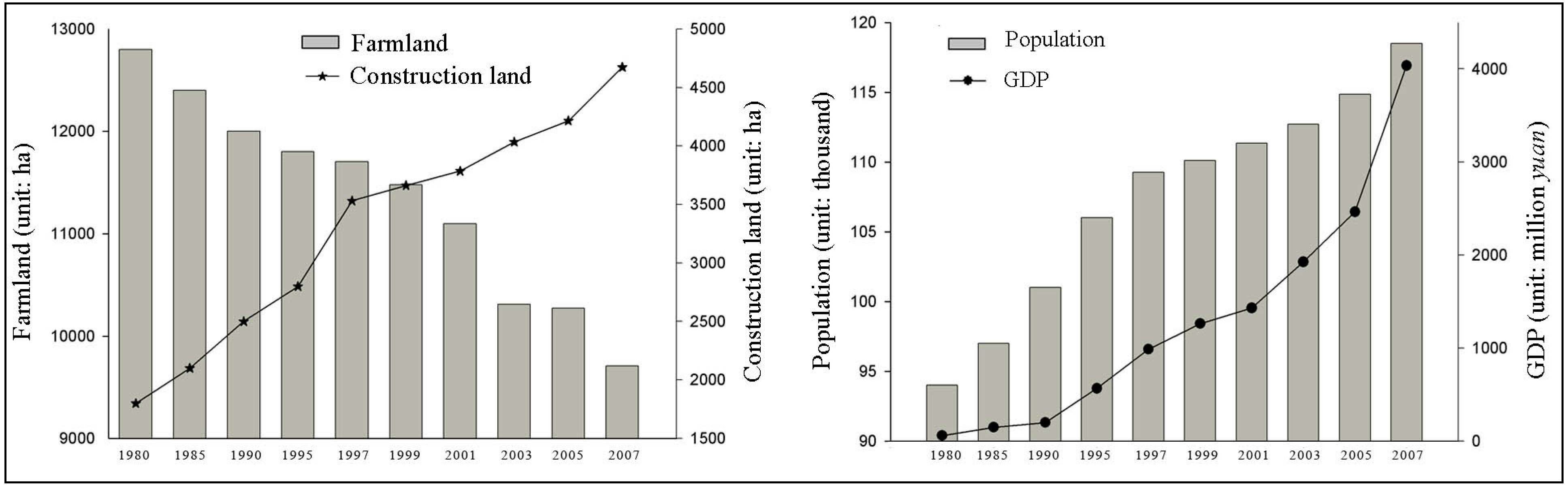
The measures listed above should preserve farmland, yet according to the official census, the area devoted to farmland in Dachang nevertheless declined from 11,704 ha to 9709 ha between 1997 and 2007, which is a loss of nearly 10% (
Figure 2).
Figure 2.
Land use change and socio-economic development in Dachang County between 1997 and 2007.
Figure 2.
Land use change and socio-economic development in Dachang County between 1997 and 2007.
4. Analysis of Dachang’s Farmland Loss
Although the reasons for farmland loss are complex, they can generally be classified into internal factors and external factors.
4.1. Internal Factors for Farmland Loss—Industrialization and Urbanization
The urbanization and industrialization taking place in contemporary China make farmland loss inevitable [
6,
28]. This is especially the case in Dachang. The loss of farmland is a direct result of Dachang’s remarkably successful economic development in recent decades, which has resulted in rapid urbanization and the conversion of enormous amounts of farmland into residential, industrial, commercial, infrastructure and institutional uses.
In 1997, Dachang had 110 thousand inhabitants, and its GDP was only 987 million
yuan. Between 1997 and 2007, the population increased at an annual growth rate of 0.8%, reaching 118.5 thousand in 2007. During the same period, GDP increased at an amazing annual growth rate of 15.1% (approaching 4034 million
yuan in 2007), that is, nearly 20 times the rate of population growth [
29]. As a result of this social and economic development, the amount of construction land grew from 3532 ha to 4673 ha, a 32.3% increase.
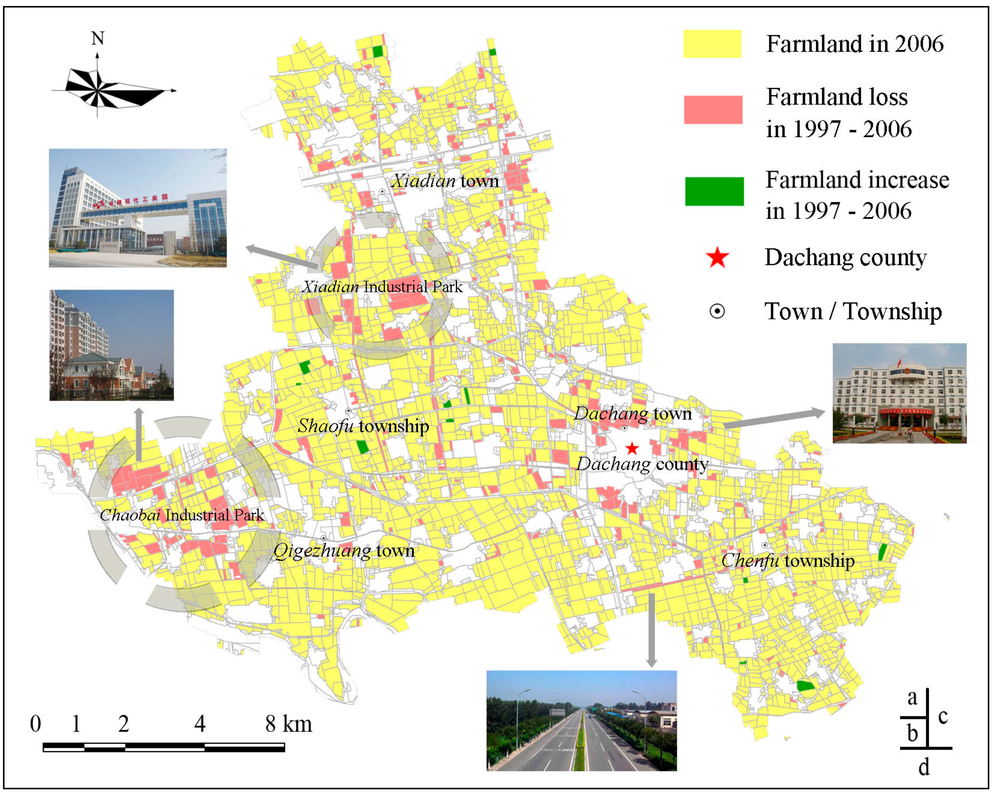
From a spatial perspective, as shown in
Figure 3, a substantial amount of the former farmland is located in the
Chaobai Industrial Park and
Xiadian Industrial Park, which both are provincial level industrial parks. To increase the government’s share of business income taxes, Dachang expanded the scope of its industrial parks to accommodate more enterprises [
30]. Of these enterprises, over 80% have close relationships with Beijing. They relocate from Beijing to take advantage of relatively low land prices or if their industries are prohibited in Beijing, such as the heavy chemical industry. The increase in infrastructure and institutional land accounted for substantial farmland loss. To attract more potential investors and industrial capital, Dachang made large-scale infrastructure investments to provide the necessary public facilities. This accelerated farmland loss. In our survey, these enterprises account for 70% of farmland loss.
Figure 3.
Map of the distribution of farmland loss: most of the farmland was converted into (a) industrial parks; (b) apartments; (c) government offices; (d) highways and transportation facilities.
Figure 3.
Map of the distribution of farmland loss: most of the farmland was converted into (a) industrial parks; (b) apartments; (c) government offices; (d) highways and transportation facilities.
In addition to industrial land use, commercial and residential land use also account for an important share of farmland conversion. The continuing growth of Dachang’s economy has drawn farmers from around the county into Dachang’s downtown in search of work, further increasing the need for office buildings and residence space. According to the data, approximately 2000 farmers moved into downtown Dachang each year, requiring the conversion of 20 ha farmland into construction land. Farmland located on the periphery of downtown areas with development potential is frequently developed into commercial and residential buildings. Thus the question of how to address abandoned rural settlements represents a significant challenge for other similar counties.
It is important to note that, in 2004, the Chinese government reformed its farmland conversion policies. The previous four-level mechanism (state-, provincial-, city-, and county-level) for the approval of farmland conversion was abolished. Under the new system, the national and provincial governments were given authority over the approval of farmland conversion. The central government is responsible for approving the conversion of prime farmland or farmland parcels exceeding 35 ha, while the provincial government is responsible for approval regarding parcels smaller than 35 ha. While this measure was carefully devised, it nonetheless failed to check farmland loss. The reason is that the local government has not abided by the regulation. It is common for local land users to divide large parcels of farmland into smaller pieces prior to seeking conversion approval, thereby avoiding the need for national or provincial approval. As a result, local staff estimated that approximately 280 ha of farmland were converted into construction land, conversions that should have been approved by the national government but were not.
4.2. External Factors for Farmland Loss—Policy Failures
While the loss of farmland strongly supports economic development and construction in Dachang, this does not mean that the loss of farmland is necessary, and such lands could be better protected. Despite the existence of two rounds of land use planning and land consolidation planning intended to preserve farmland, several key issues have hampered the effectiveness of these planning processes. These issues are attributable to the lack of experienced planning guidance, which is indirectly responsible for farmland loss.
One issue is the lack of attention devoted to the distribution of farmland during the planning process. As shown in
Figure 4, during the second round of land use planning, the planners neglected small parcels of farmland and devoted greater attention to urban areas. Thus when the plan was implemented, the new construction land was distributed such that the farmland became too fragmented to irrigate. Over time, small farmland parcels located among construction lands became idle and abandoned [
31]. In our survey, the local farmers all felt that had the plan been more well considered, at least 10% of the farmland loss could have been avoided.
Second, inadequate regulation of the land use zones is also an important factor. The management of agricultural land zones, which include prime farmland, orchards and fishponds, is difficult regarding non-farm uses. This is because national law strictly regulates the use of prime farmland for non-farm uses, while orchards and fishponds are rather easily converted into construction land. Therefore, it is difficult to use one general regulation for the preservation of different types of farmland. We also find that the land use zones area relatively poor mechanism to effectively manage farmland. Even prime farmland could not be effective protected.
Third, the irrational arrangement of land consolidation projects also resulted in farmland loss. While county-level land consolidation plans exist, there is no clear site for land consolidation program. When the provincial office established projects to meet the annual land consolidation quota, officials in Dachang would repeatedly check the maps in an attempt to identify a suitable consolidation site. Due to the temporary and random selection of the consolidation sites, lacking consideration of the land use information, the outcomes were poor.
Figure 4.
Farmland scatted among rural settlements.
Figure 4.
Farmland scatted among rural settlements.
Fourth, the land use and consolidation plans ignored the rural settlement plans. As mentioned above, over the past ten years, more than 4000 households (approximately18,000 persons) moved into the downtown area and left the rural settlements. The total areas abandoned reached 700 ha. In our survey, approximately 70% of the rural settlements are abandoned or too dilapidated to accommodate residents. These lands could be returned to farmland and thereby reduce the area devoted to low-density construction land.
Finally, while a land use planning process exists, the implementation of the resulting plans has been poor. The illegal use of farmland has been commonplace. These incidents of illegal land use were caused by two groups. The first was business owners in the townships. Due to the low construction quota, most firms in the townships were unable to obtain construction permits. Thus the owners of businesses in the township had to convert farmland into construction land without completing the requisite legal formalities. These activities accounted for approximately 85% of the total cases observed. The other group is villagers. They occupied farmland to build agricultural structures, such as henhouses or tool sheds. The farmers in our survey are under the impression that these behaviors are legal and do not require permits from the government, while they are actually required to obtain a license from the local land resources bureau. Because they were operating outside the quota system, the villagers were not compelled to compensate for farmland used for construction purposes with an equal amount of farmland.
5. Measures for Farmland Preservation in Land Use Planning
Despite the presence of the relevant measures, due the issues noted above, farmland area has continued to decrease, threatening the sustainability of Dachang’s development. In 2005, during the third round of land use planning, the government adopted previously successful measures and innovative techniques to preserve farmland and pursue the following goals: preserve agricultural lands; create open spaces and recreational opportunities for residents; and improve land use efficiency. The measures adopted were considered sufficiently systematic and comprehensive to achieve the goal of farmland preservation. Three of these measures were the establishment of farmland preservation zones, restrictions on urban sprawl and the implementation of land consolidation programs.
5.1. Establishment of Farmland Preservation Zones
The Land Administration Law of the People’s Republic of China and Regulations on the Protection of Prime Farmland (released on 1 January 1999) specified that all individuals and organizations have the duty to protect prime farmland and the right to disclose and report acts of illegal occupation, impairment of said prime farmland, or other acts in violation of these regulations. Moreover, the use of prime farmland for any type of construction should be placed under the strictest scrutiny. Any firm or individual who wishes to change the use of a parcel of land in a prime farmland zone must submit an application to and receive permission from the state council.
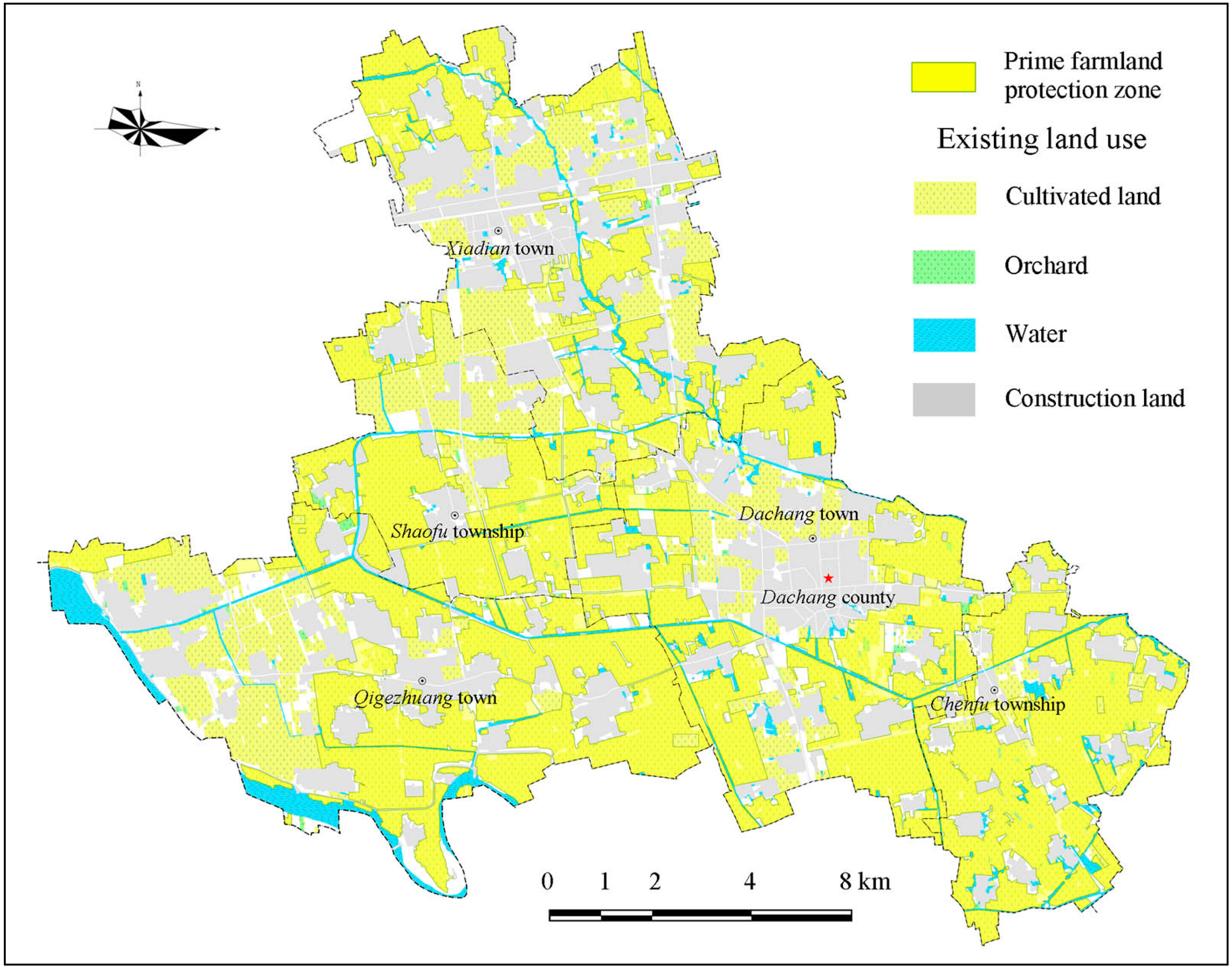
To avoiding managing prime farmland using a single type of zone (agricultural land zone), the third round of land use planning, farmland preservation zones were established to encourage farmland preservation [
32]. These zones are divided into prime farmland preservation zones and ordinary agriculture zones (
Figure 5). Both zone types are included on the planned land use map [
33]. Moreover, in an attempt to better protect prime farmland, a thematic map—the prime farmland map—is also produced (
Figure 6).
Figure 5.
Map of proposed land use.
Figure 5.
Map of proposed land use.
Figure 6.
Map of prime farmland preservation.
Figure 6.
Map of prime farmland preservation.
The land included in prime farmland zones is determined in accordance with the public’s need for agricultural products, the needs of the national economy, and a forecast of the amount of land required for construction purposes over a specified period of time. These zones apply to five classes of land: (1) ‘‘cultivated land’’ currently sown with food grains, cotton, and oilseeds; (2) “cultivated land” with good irrigation, drainage, and erosion control, along with medium and low quality land on which irrigation, drainage, and erosion control measures are being installed; (3) land planted with vegetables; (4) experimental plots for agricultural research and development; and (5) other cultivated land as determined by the state council.
Construction on farmland in ordinary agriculture zones is less strictly regulated. If farmland needs be occupied, this should be accompanied by development and reclamation. For non-agricultural construction that truly warrants the use of farmland, the area to be developed and reclaimed must not be less than that occupied, and the reclamation must comply with the quality standards for cultivated land. Moreover, the funds required for the reclamation and development of farmland must be included in the total investment for the construction projects as land costs.
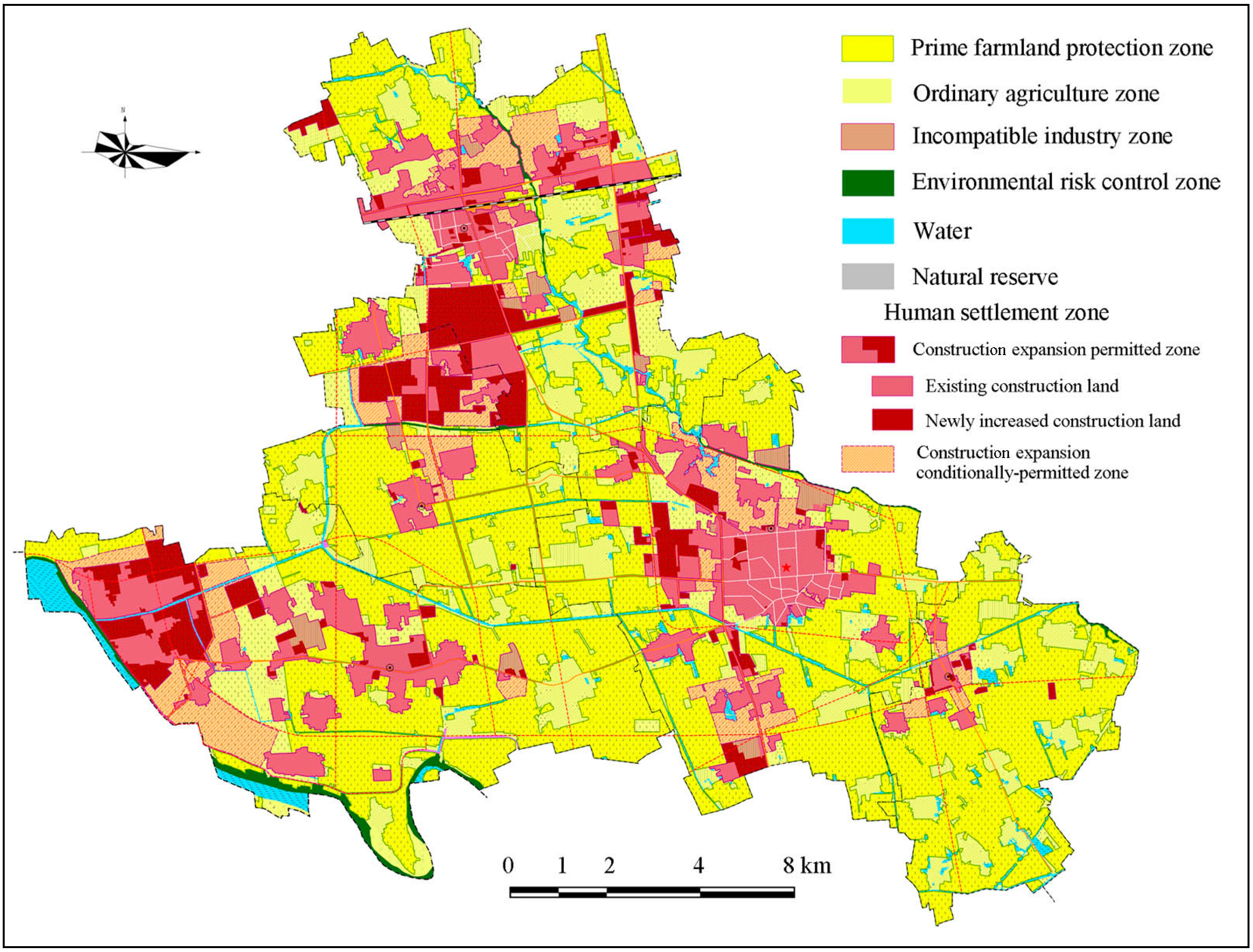
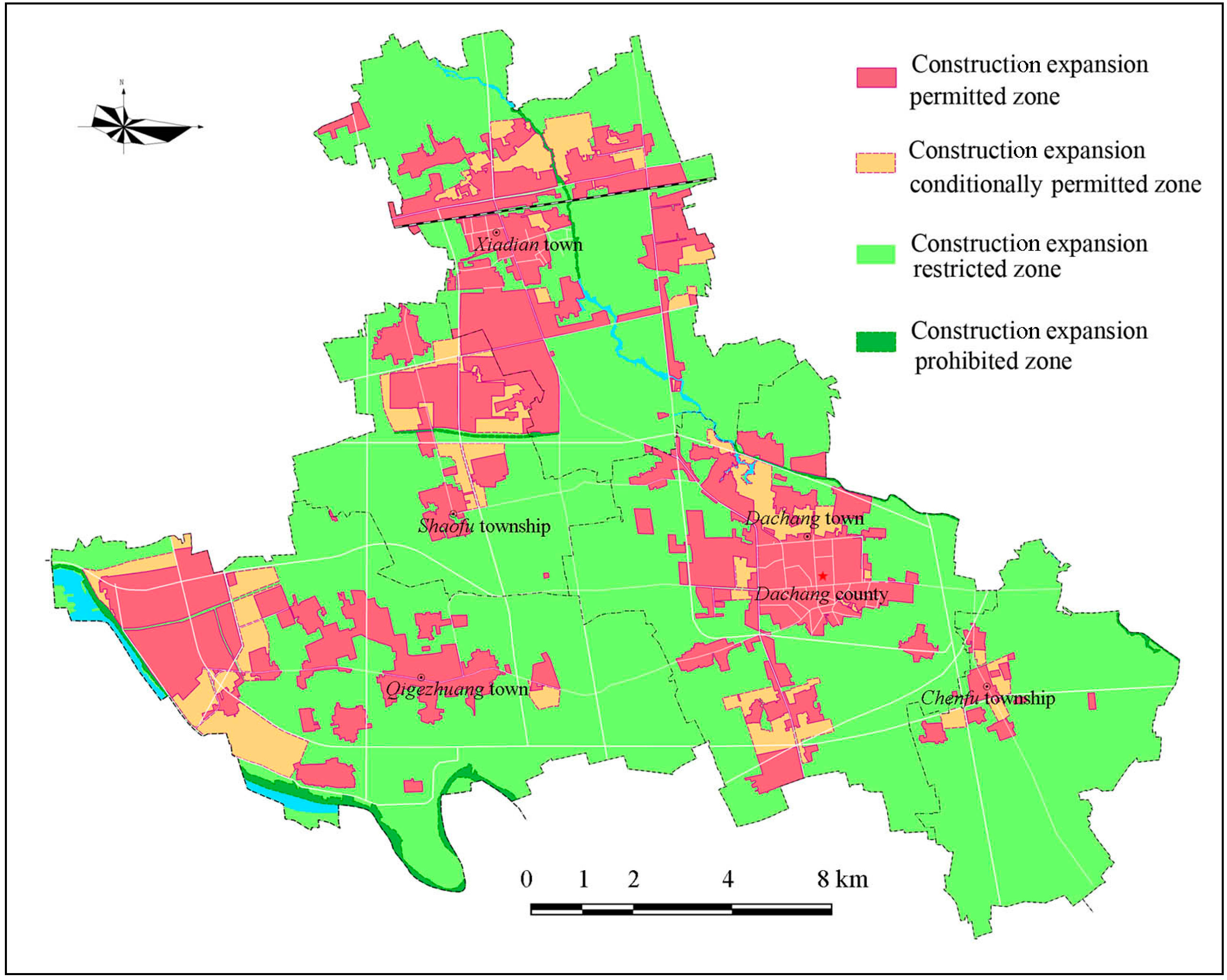
5.2. Creation of Construction Expansion Zones
The expansion of construction is one of the main reasons for farmland loss [
34]. Therefore, constraining the increase in construction land is necessary to protect farmland. To control sprawl and disorderly human settlements and realize smart growth, four zone types are used: construction expansion permitted zones, construction expansion conditionally permitted zones, construction expansion restricted zones and construction expansion prohibited zones [
35].
Figure 7 is the zoning map regulating the expansion of construction. It was compiled by the Planning Bureau of Dachang County [
36].
Figure 7.
Map of construction expansion zone.
Figure 7.
Map of construction expansion zone.
The zones are designated according to the following principles: (1) reasonably controlling the total amount of construction land and practically protecting cultivated land; (2) ensuring a balance between the occupation and replacement of cultivated land; (3) prioritizing land required for key state construction and infrastructure projects; (4) linking the increased urban construction land with the decreased rural construction land; and (5) protecting and improving the natural environment and guaranteeing the sustainable use of land.
Construction expansion permitted zone are areas where existing urban and rural construction land and new construction land can be legally located. The amount of new construction land should be consistent with the quota issued by the provincial-level government in the annual plan.
Construction expansion conditionally permitted zones are reserved for new construction land, which generally accounts for 30% of the quota for new construction land contained in the annual plan. Land in these zones can only be used for urban land development with the official approval of a public request; otherwise it must be regulated under the agricultural use standards.
In construction expansion restricted zones, the land is primarily used for agriculture and environmental purposes. Land development is not permitted in this zone, even though it does not have negative effects on the natural environment. Only new land for energy, transportation (such as highways and railways), water conservation projects, etc., the locations of which are independently selected, can be built in these zones.
The land in construction expansion prohibited zones is primarily environmental sensitive land, which includes mountains, water reservoirs, and open green space. Any development is forbidden except for the purposes of environmental protection. Generally the zones are employed as green hearts in the downtown areas and greenbelts in the urban-rural fringe.
Construction expansion permitted zones are the planned areas where human settlements can be legally located, while construction expansion conditionally permitted zones are elastic zones for new human settlements. These zones can only be used for human settlement with special public requests and official approval; otherwise they must continue to be regulated following agricultural use requirements. In the construction expansion prohibited zones, any new construction is forbidden except for environmental protection purposes. In construction expansion restricted zones, only linear construction projects (such as highways and railways) can be constructed. The construction expansion zones both effectively constrain the spatial distribution of construction land.
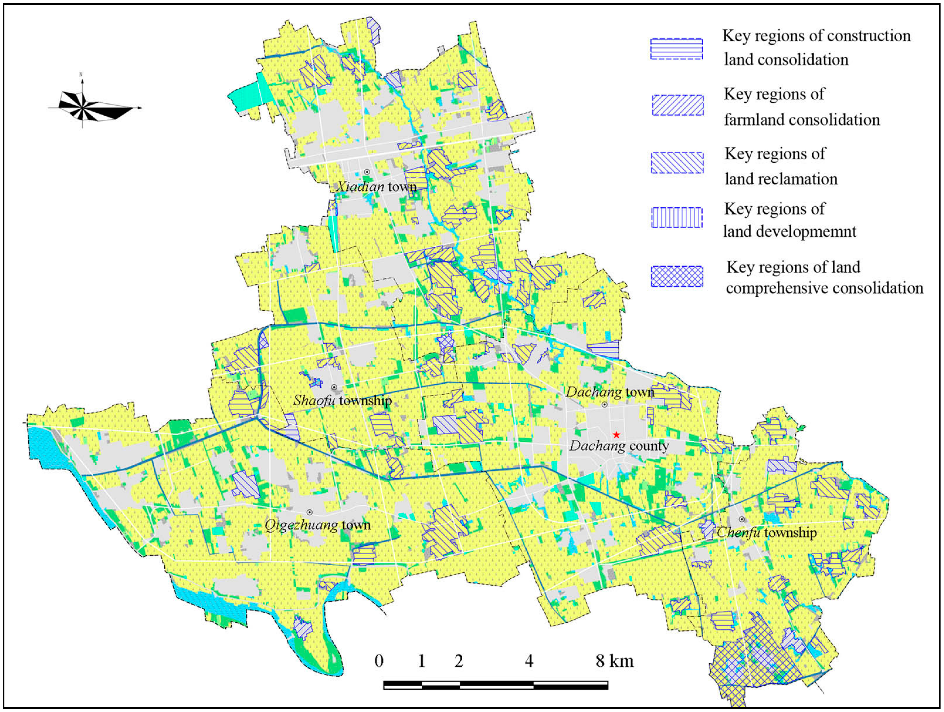
5.3. Arrangement of Land Consolidation Zones
As mentioned above, low intensity land use has substantial potential and land consolidation arrangements are crucial to farmland preservation. The land use plan devoted greater attention to these issues. When the provincial government established the land consolidation quota, it included the quantity of land consolidation, reclamation and development. The consolidation of construction land refers to merging, removing or refurbishing local rural constructional land, with the ultimate goal of identifying plots with the potential for highly intensive use. Farmland consolidation refers to changing agricultural land structure; merging scattered plots; and constructing shelter belts, ditches and other projects. Land reclamation refers to the remediation of land damaged by construction activities and natural disasters, such as mining land, to restore the damaged land to farmland. Land development refers to the creation of new farmland from rivers lakes or other unused land through biophysical or engineering measures. These four types of activities are the main sources of farmland growth.
Figure 8 indicates the distribution of the key regions for construction land consolidation, farmland consolidation, land reclamation, and land development. Each zone has a quota for consolidation work. New construction land quotas for the next year are only awarded once consolidation tasks have been completed locally.
Additionally, the plan also made arrangements for abandoned and dilapidated rural settlements (
Figure 9). A new and innovative measure of “linking the increase in urban construction land with the decrease in rural construction land” was included in the plan [
37,
38,
39]. This measure entails combining land blocks containing rural settlements that are to be demolished and reclaimed as arable land (land blocks where old buildings will be dismantled), land blocks to be used for urban construction (land blocks where new buildings will be built) and other areas on the basis of the overall land use plan to construct a project area where old buildings will be demolished and new ones built (hereinafter referred to as the “project area”). The ultimate goal of this measure is to achieve the objective of increasing farmland, economically and intensively using construction land, and developing a more reasonable configuration of urban and rural land use through such measures as demolishing old buildings and building new ones, land clean-up and reclamation, with the aim of ensuring a balance between all types of land in the project area. When the measure was implemented, the quantity of construction land did not increase and the quantity of farmland did not decrease.
Figure 8.
Map of land consolidation arrangement.
Figure 8.
Map of land consolidation arrangement.
Shown in
Figure 9, according to the county’s town/village development strategy, approximately 50 villages (with a total area of 1200 ha) were included the rural settlement consolidation zone. During the implementation period, the local governments were required to control the rural settlements’ scale, and no new homes could be built in this zone. The government then gradually selected houses in the zone for land consolidation and simultaneously built new houses in the construction expansion permitted zone.
Figure 9.
Map of rural settlement consolidation.
Figure 9.
Map of rural settlement consolidation.
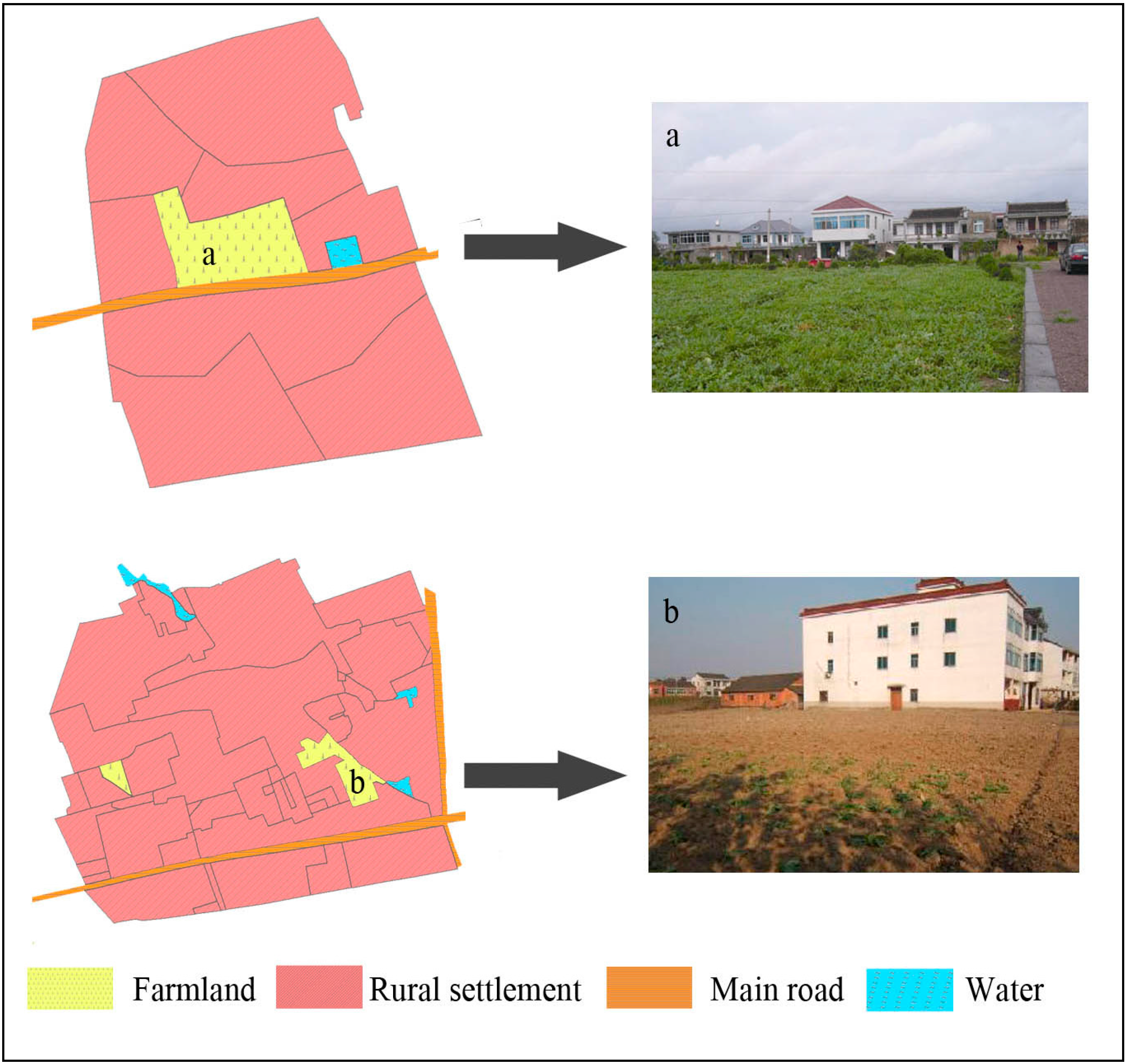
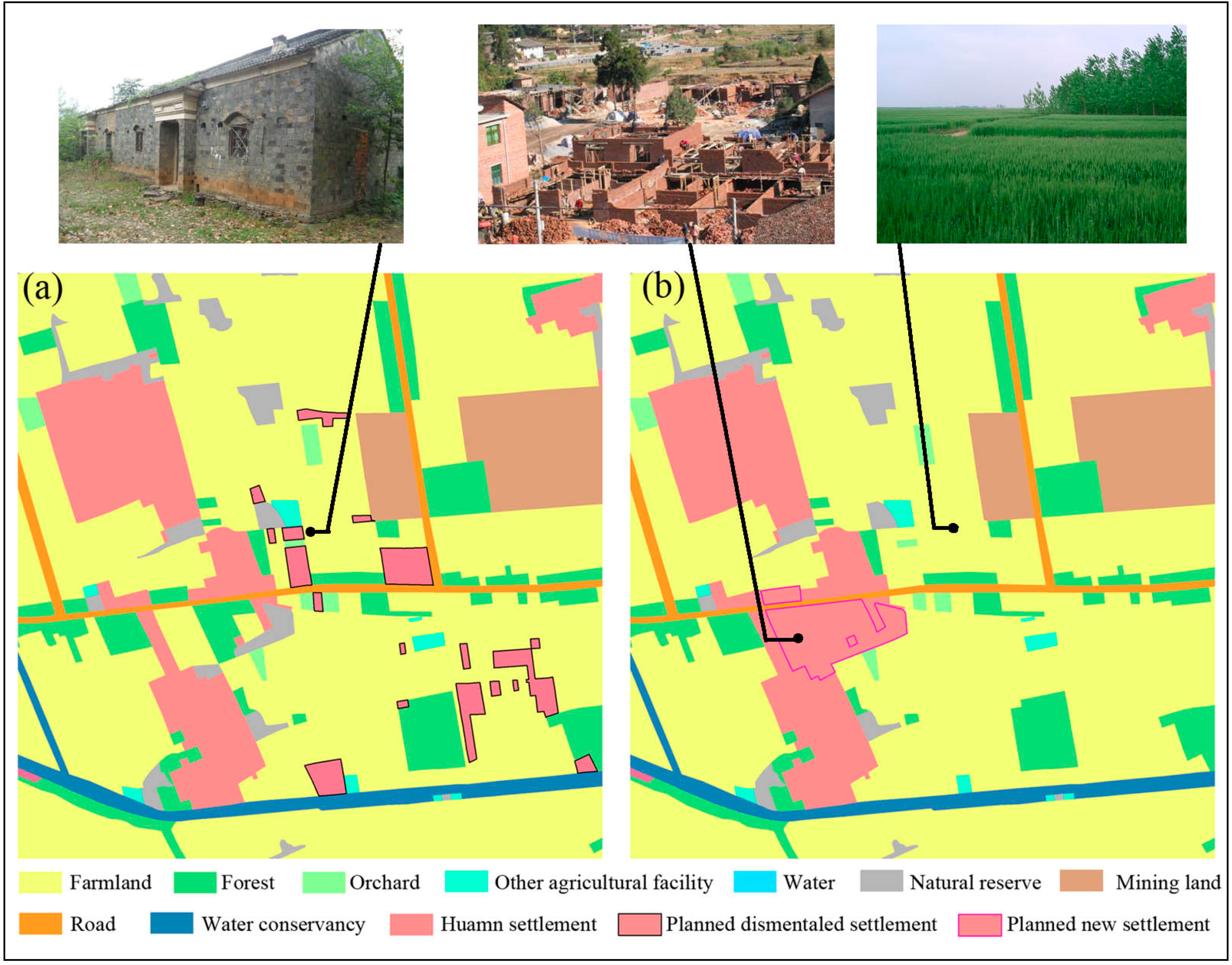
Figure 10 presents images before and after the rural settlement consolidation activities. In this image, scattered and abandoned rural settlements are reclaimed as farmland and new houses are built near existing houses. In this way, farmland is consolidated into larger plots, which facilitates cultivation, while construction land plots are used more intensively and do not increase in size.
Figure 10.
Image “Linking the increase in land used for urban construction with the decrease in land used for rural construction” (a) before land consolidation and (b) after land consolidation.
Figure 10.
Image “Linking the increase in land used for urban construction with the decrease in land used for rural construction” (a) before land consolidation and (b) after land consolidation.
6. Conclusions
As the third plan has been implemented for seven years, it achieved better results with respect to farmland protection than prior efforts. The area devoted to farmland decreased slightly (from 9612 ha to 9279 ha), which is an inevitable result of the area’s rapid urbanization and industrial development.
First, the design of the prime farmland preservation zones and ordinary agriculture zones is reasonable and practicable. The differentiated regulations both strictly protect prime farmland and flexibly promote other uses of formerly cultivated land.
Second, the design of construction expansion zones effectively controls the spread of construction land, which indirectly curbs farmland loss. As noted above, most new construction land zoned over the past seven years was not located on existing farmland. Only approximately 3% of the farmland located in ordinary agricultural zones or prime farmland zones was occupied. All of this lost farmland was the result of highway construction. These zones both decreased the use of farmland for other purposes and reduced the amount of abandoned farmland near human settlements.
Finally, the land consolidation plan earned the praise of the local populace, especially due to the popularity of “linking the increase in urban construction land with the decrease in rural construction land”. This is because by using this planning measure, both collective enterprises and farmers are able to easily construct buildings outside the quota system, as long as they reclaim a certain quantity dilapidated construction land. As noted above, a total of 436 ha of rural settlements were reclaimed as farmland, and only 300 ha of farmland were used to settle farmers, most of whom accepted government subsidies and purchased apartments in the downtown area. In our survey, the LRB staff reported that if this trend continues the planned rural settlement consolidation zone would be completed within five years. At that time, the governments involved would designate other abandoned rural settlements for consolidation.
Dachang is typical and representative of the over 5000 counties in contemporary China. The rapid loss of farmland in Dachang represents a microcosm for Chinese counties facing rapid urbanization and industrialization [
40]. The measures highlighted here have the potential to serve as examples of how they can preserve farmland and build better communities. Despite having over 20 years of experience in preserving farmland through land use planning, China continues to search for better methods. In July 2010, the Ministry of Land Resources launched the second national land consolidation planning process [
41,
42]. Its goals are to improve production and living conditions in rural areas and coordinate urban and rural development, optimize the land use system and use land economically and intensively. The three measures illustrated here could not only effectively improve food production and spur agricultural development but also improve the development of the entire national economy and social stability. It is certain that an improved understanding of land use planning on the part of China’s land resources management department, better measures will be developed in the near future to ensure farmland preservation.


