Abstract
Global and regional climate change and their water-related impacts are a key component in future development scenarios to guide sustainable water management. Climatic changes may lead to an undesirable redistribution of water supplies and potentially harmful extremities in river flows throughout the year. If we add to this the uneven spatial distribution of water resources in Kazakhstan, the importance of assessment of the intra-annual distribution of river flows under historical and present climatic conditions becomes evident. The presented scientific study analyzes decadal regional trends from 1985 to 2022 in the intra-annual distribution of river runoff in selected catchments in Kazakhstan, including Buktyrma River, Zhabay River, and Ulken-Kobda River. The river basins were selected to cover diverse regions in terms of geographical features and hydrological conditions, significantly affected by climate change. We applied statistical analysis methods using multiyear values of mean monthly and mean annual river flows, mean monthly air temperatures, and mean monthly precipitation. To analyze the intra-annual distribution of annual river flow in the context of climate change, a computational method was used, in which the actual current river flow (modern river flow taking into account non-stationarity of climatic changes) was compared with the conditionally natural flow obtained by modeling and corresponding to the natural regime of the river. The long-term dynamics of flow-forming factors and runoff parameters with regard to phases of different water content (25%, 50%, and 75%) were considered. Statistical analysis of seasonal changes in water content of modeled and actual river flow, taking into account climatic non-stationarity, allowed us to identify significant trends of flow redistribution within the year: indicating a decrease in the volume of spring floods, an increase in winter flow and increase in seasonal variability, especially for the Ulken Kobda River. It appears that atmospheric circulation significantly affects annual and seasonal variations of water availability. The shift in western circulation type (W) contributes to increased average annual river flow, while the shift in eastern circulation type (E) is associated with amplification of extreme flood-type events. The results obtained are important for adapting sustainable water management practices under a changing climate, helping to anticipate the availability of water resources and allowing pro-active measures to mitigate hydrological extremes.
1. Introduction
Global climate change and anthropogenic activity contribute to significant changes in the ecological and hydrological characteristics of river flow worldwide [1,2,3,4,5,6,7,8]. Climatic changes observed on the globe in the 20th and 21st centuries also affected Kazakhstan, where for the period 1941–2015, seven out of the ten warmest years fell at the beginning of the 21st century [9]. Smirnova, Dolgikh, and others have shown [9] that in Kazakhstan, the average annual temperature increases about 0.3 °C every ten years, with an expected further significant warming in the 21st century. The average annual temperature is expected to increase by 1–2 °C by 2030 and by 2–3 °C by 2050. The increase in winter and summer temperatures could reach 2 °C by 2030 and 2–3 °C, and even more in the northern regions, by 2050. The same study also indicates an increase in precipitation by 2050, regionally reaching annual increases of 10%, and possibly even higher values in the northern, central, and mountainous regions of the southeast. The amount of winter precipitation is projected to increase by 10 to 20% by 2050. In some central and mountainous regions, the increase in winter precipitation by 2050 may exceed 20%. The expected trends of summer season precipitation are more heterogeneous throughout the country, indicating increases of 10% in some areas and precipitation reduction in other areas (especially in southern regions). The main conclusion of the study is that winters in Kazakhstan will be warmer and more humid. This is especially true for the northern, foothill, and mountain regions. In many months of the warm season, it will also be significantly warmer, but at the same time drier. This unfavorable trend is most pronounced in the southern, southwestern, and western regions of Kazakhstan [10].
These ongoing and projected climate trends have important implications for the sustainable water use in Kazakhstan. Spring flood events are expected to occur more frequently, while during summer months, more frequent and more severe occurrences of droughts are expected. To ensure Kazakhstan’s sustainable development and use of water resources, an assessment is needed of the potential impacts of possible future climate change, including the identification of timely and adequate adaptation measures.
Understanding of the annual distribution of river flows is important for the rational and integrated use of water resources, and depends on various factors. These include, besides geographical features, also various climatic conditions, such as amount and mode of precipitation, amounts of evaporation from water bodies, and melting of seasonal snow and from glaciers [11,12]. In Kazakhstan, the intra-annual distribution of river flow and the characteristics of the water regime were given great attention in monographs such as Surface Water Resources of the USSR, which covered observations from the beginning of hydrological observations until the 1970s. Various classic scientific works in river basins of Kazakhstan cover the patterns of intra-annual distributions of river flow and hydrological extremes, see for example Kuzin P.S. [13] for the southern regions of Western Siberia, Northern and Central Kazakhstan, Skotselyas N.I. on intra-annual distribution of river flow for unexplored rivers of Gornyi Altai [14], and Berkaliyev Z.T. on the hydrological regime of the rivers of Central, Northern and Western Kazakhstan [15]. Modern studies of intra-annual distribution of river flow, including later observation periods, are summarized in monographs by. Galperin [16], Dostai et al. [17], and studies of the hydrological regime of the rivers of Kazakhstan [18,19,20,21]. For intra-annual distribution of river flow of the northern slope of Zhetysu Alatau [22]; of the river basin Ertis—A.A. Tursunova [23]; of the Shu and Talas River basins—K.M. Kulebayev [24], Zhaiyk-Caspian basin—S.K. Davletgaliyev [25].
It is critical that methods and methodologies for calculating the intra-annual runoff distribution be analyzed in terms of their correct reflection of existing natural patterns of intra-annual flow. The purpose of this research is to study the current intra-annual flow distribution in typical basins of the Buktyrma, Zhabay, and Ulken Kobda rivers. Understanding the identified trends will help to develop more effective strategies for water management and adaptation to changing climate conditions.
2. Materials and Methods
2.1. Study Areas
The studied rivers were considered typical river catchments located in different natural and climatic conditions, and determining the value of water resources for various sectors of the economy: agriculture, domestic household, hydropower, etc. [26,27]. These river basins were selected as regions characterized by different geographical features of flow formation, significantly affected by climate change. Assessing the impact of these changes on the water regime of the rivers will provide a deeper understanding of the peculiarities of their hydrological regime, the impact on different sectors of the economy, and opportunities for mitigating negative impacts during the spring floods and rational water management depending on the river regime throughout the year. The main characteristics of the rivers under consideration are reflected in Table 1. Catchment areas in the closing sections: Buktyrma River–Lesnaya Pristan village, Zhabay River–Atbasar city, Ulken-Kobda River–Kobda village are shown in Figure 1.

Table 1.
Main characteristics of the catchments under study.
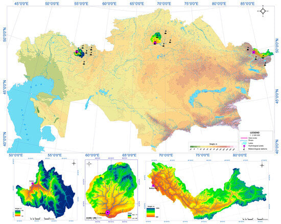
Figure 1.
Catchment areas: Ulken Kobda River–Kobda village, Zhabay River–Atbasar town, and Buktyrma River–Lesnaya pristan village.
Buktyrma is one of the largest rivers of Altai, belonging to the Ertis River basin. It flows through the territory of the East Kazakhstan region. The catchment of the Buktyrma includes the most important tributaries, such as the rivers Belaya Berel, Sarymsakty, Khamir, and Berezovka, which contribute to maintaining a constant water flow throughout the year. River alimentation is mixed: 50–55% snow, 25–35% rain, and 15% ground [28,29]. The main hydrological element—the Buktyrma reservoir—serves as an important link in the system of water management, helping to mitigate the consequences of the spring high water and ensure a stable supply of water resources in the summer [30]. The research area covers the catchment area up to the river station of the village Lesnaya Pristan, where constant monitoring of the water level and water quality is carried out.
Zhabay River is the right tributary of Esil, flows through the territories of Sandyktau and Atbasar districts, and its water regime has a significant impact on agriculture and water supply in the region. The river has 14 tributaries, including Coluton, Terisakkan, and Imanburlyk, which play an important role in maintaining the hydrological balance. The water intake territory of the river from the stream flow measuring station of Atbasar town is studied in order to analyze seasonal changes in the water level and for the forecast of high water. The freezing of the Zhabay River occurs in early November and ends in mid-April, which allows for making a prognosis of the river behavior in the spring and effectively planning water supply for agriculture. Particular attention is paid to the study of water resources to prevent negative consequences associated with spring floods and climate change [31].
Kobda River, which is formed as a result of the confluence of Kobda and Sary Kobda rivers. It is an important hydrological object for the Aktobe region. Kobda River inflows the Elek River and is an important water source for the region, ensuring water supply to both agriculture and the population. Kobda flows along the border with the Orenburg region, and its studied area includes a river mouth area of 14 km long. The river alimentation is mainly rain, which makes its water regime especially sensitive to changes in climatic conditions. The main tributaries, such as Terisakkan, Saukain, and Tamdy rivers, affect the general dynamics of the water balance in the basin. It is important to note that monitoring in this area helps to optimize the use of water resources and form a prognosis of changes in the hydrological regime of the river in conditions of unstable climatic phenomena [32].
2.2. Intra-Annual Flow Distribution
By calculating the intra-annual distribution of river flow in the work, the official data of the RSE “Kazhydromet” was used URL: https://www.kazhydromet.kz/ru/gidrologiya/ezhegodnye-dannye-o-rezhime-i-resursah-poverhnostnyh-vod-sushi-eds (accessed on 10 September 2024).
Data processing was carried out for the time period from 1985 to 2022. Hydrological calculations and statistical analysis were carried out using standard MS Excel and Statistica packages.
Trends in intra-annual flow distribution were assessed by standard statistical analysis methods. Spatiotemporal analysis, real-year method, composition method, and monthly flow duration curves were used to describe the intra-annual distribution of runoff.
According to the Code of Rules and Building Codes [33,34], calculations of intra-annual distribution of river flow are carried out for the calendar, water management, or hydrological year. In this work, in order to compare the intra-annual distribution of river flow, calculations of the river regime were made using two methods: the real year method and the composition method (method of Andreyanov). The performed studies will allow updating the data on intra-annual flow distribution.
The method of Andreyanov V.G. [35] is used for assessing rivers on the annual flow distribution, including the water content from snow contributions. The method is based on the acceptance of (i) the equality of the availability of flow for the year, (ii) the limiting period, and (iii) the limiting season. In the ”real year method”, three representative years are selected with water volumes that correspond with 25%, 50%, and 75% bounds of the overall multi-year water volume distributions. In the “composition method”, statistical yearly water-volume distributions are derived that correspond to the same 25%, 50%, and 75% bounds.
The method of calculating the annual distribution according to the real year model does not exclude subjectivity when choosing such a model, and the probability of annual flow and flow of the limiting period and season within the real year is not always unambiguous.
Often, the annual flow indicators average the changes that occur within the year in the flow distribution and do not reflect the real picture of changes in the river’s water regime. The flow of the Buktyrma, Zhabay, and Ulken Kobda rivers is characterized by high inter-year and intra-year variability, and the flow volumes of frequent low-water and rare high-water years may differ by a factor of two or more.
The characteristics of changes in the intra-annual flow distribution of rivers were determined by taking into account climatic changes, which occupy a central position in the issue of water supply and water use. Analysis of intra-annual distributions of annual runoff with regard to climate nonstationarity was carried out by computational methods, in which domestic runoff, which already carries changes in climatic characteristics, is compared with conditionally natural runoff values reconstructed by means of modeling.
To estimate natural flow taking into account climate change, water flow rates of the studied rivers were modeled using the hydrological model SWIM (Soil and Water Integrated Model) developed at the Potsdam Institute for Climate Impact Research (Potsdam Institute for Climate Impact Research, Germany). The process of model development was described in detail by V. Krysanova [36]. Comparison and evaluation of different hydrological models, as well as conclusions about the application of SWIM, were discussed in the works of C. Gao [37], T. Conradt [38] and A.Nurbatsina [39].
Intra-annual distribution of flow is sensitive to changes in both precipitation and air temperature. At the same time, not only is the magnitude of these changes important, but also the seasons (months) of their occurrence. Both precipitation and air temperature can play a decisive role. In addition to climatic factors, the local conditions have a great influence on the distribution of flows within the year. In mountainous areas, relief is especially influential. It determines the general humidification conditions, the availability of river basins to moist air masses, and the amount and distribution of precipitation.
Assessment of the trend in the intra-annual flow distribution of the Buktyrma, Zhabay, and Ulken Kobda rivers. The methodology of I.I. Polyak, which showed the best result in the global study of water resources of the Russian Federation, was used to statistically substantiate the presence or absence of a trend. To accept the hypothesis of a linear trend according to the method of I.I. Polyak, the following conditions must be met:
where is the standard deviation, and —is the variance of the deviation of the observed values from the trend line, where the category is determined as follows:
where R2 is the regression coefficient, and —is the mean square deviation of the regression coefficient a1, which is determined as follows:
where n is the number of years of observation.
If conditions (1) are not met, then the linear trend is insignificant with a probability of 5%.
The intra-annual distribution of river flow is also significantly influenced by atmospheric circulation. The main influence is manifested through seasonal changes in precipitation caused by circulation processes. River flow peaks in the rivers under study are usually in spring, when intensive snowmelt occurs, which leads to an increase in water flow. In spring, cyclonic processes can also be observed, contributing to additional precipitation. The summer period is characterized by a decrease in flow, especially in July and August, when anticyclonal circulation prevails in Kazakhstan, limiting the amount of precipitation. However, on the Buktyrma River, the peak of flow may extend into spring and summer, which is due to the peculiarities of the snowmelt regime in mountainous and foothill areas, as well as the influence of local climatic conditions. The influence of atmospheric circulation largely depends on seasonal transitions between different types of atmospheric processes, which is reflected in the runoff characteristics of these rivers. The direction of the predominant transport of air masses, reflected by the identified forms of atmospheric macrocirculation, should also determine the hydrological features of specific years.
According to the classification of Wangengeim G.Ya. and Girs A.A., the atmospheric circulation in the northern hemisphere is determined by the atmospheric vortex in the region of the north pole and the west-east transport. By the western type of circulation W, the planetary altitudinal frontal zone (PAFZ), along which baric formations move, stretches latitudinally. By meridional processes E and C, the latitudinal position of PAFZ is disturbed, and the inter-latitudinal exchange of mass and energy is increased. In addition, by type E, the trajectory of baric formations over Kazakhstan acquires the southern component (transfer from northern rhumbs), and by type C, on the contrary, acquires the northern component [40].
The situation is more complicated with hydrological characteristics. For example, the predominance of type E in the cold period, on the one hand, means an increased recurrence of low snow anticyclonal weather, and on the other hand, better preservation of the snow cover by the snowmelt period. The predominance for a number of years of one or another form of macrocirculation of the atmosphere makes it possible to determine certain epochs of them. The first such experience was made by A.A. Girs [41].
3. Results and Discussion
Calculations of intra-annual runoff distribution were made on the basis of observation data at three hydrological stations using the composition method (V.G. Andreyanov, 1960) [35] and the method of real year. In both methods, three gradations of water content were selected: high water (25%), average water content (50%), and low water (75%).
The intra-annual flow distribution by both methods showed (Figure 2) that for the stream flow measuring station of Zhabay River–Atbasar village in all three gradations of water content assessment, the maximum water content is observed in April (63.5–79.2% of the annual flow), which is typical for the lowland rivers. During the study period, according to the real year method, 1995 was considered the highest high-water year, with a maximum flow rate of 45.7 m3/s.
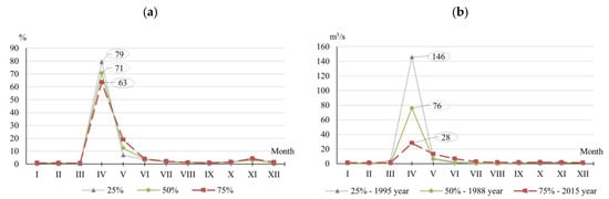
Figure 2.
Intra-annual flow distribution in the river Zhabay–Atbasar town for the years of different water content for 1985–2022. 25%—high water year, 50%—average water content year, 75%—low water year. (a)—composition method (% of annual flow), (b)—real year method.
Water content for the stream flow measuring station of the Buktyrma River–Lesnaya Pristan village in the high-water year lasted 4–5 months. Buktyrma River is characterized by extended spring-summer floods and floods in the warm season. For 4–6 months of the high-water period, 60–80% of the annual flow was registered (Figure 3). In the high-water year, 1992, the flood peak value was 880 m3/s.
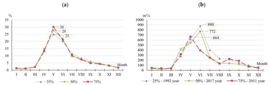
Figure 3.
Intra-annual distribution of flow in the Buktyrma River–Lesnaya Pristan village for years of different water content for 1985–2022. 25%—high water year, 50%—average water content year, 75%—low water year. (a)—composition method (% of annual flow), (b)—real year method.
The water content of the Ulken Kobda River in high-water and average-water content years is characteristic of lowland rivers, where about 80% of the flow is distributed during 2–3 months of high water. The largest monthly flow is mainly observed in April (Figure 4).
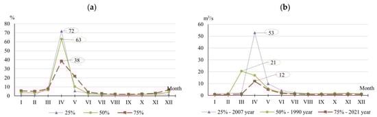
Figure 4.
Intra-annual flow distribution in the Ulken Kobda River–village Kobda for years of different water content for 1985–2022. 25%—high water year, 50%—average water content year, 75%—low water year. (a)—composition method (% of annual flow), (b)—real year method.
After analyzing the obtained results and following the calculation methodology, it can be concluded that the method of calculating the intra-annual distribution using the real-year model does not eliminate subjectivity in model selection and in estimating the annual runoff, as well as in determining runoff during limiting periods and seasons. The method proposed by Andreyanov V.G. [35] offers several advantages. One of the key strengths of this method is its ability to account for changes in runoff depending on the water availability of the year. This is particularly important for rivers where there is significant variability in runoff between high-water and low-water years, a characteristic common to rivers in Kazakhstan. Unlike methods such as histograms or duration curves, which often fail to capture such variations, Andreyanov’s method enables a more accurate assessment of the impact of climatic changes on runoff distribution. Furthermore, Andreyanov’s method facilitates the efficient partitioning of runoff into distinct phases of water availability, such as high-water, mid-water, and low-water years, making it particularly useful for analyzing seasonal variations. This capability enables more accurate predictions of periods with maximum and minimum flows, which is crucial for effective water resource management, especially in the context of climate change. The method’s simplicity and robustness are additional significant advantages. In contrast to regression analysis or exponential smoothing, which may rely on the quality and predictability of the data, Andreyanov’s method emphasizes the use of real-world data and avoids excessive assumptions or complex calculations. This makes the method both practical and reliable for use in the face of a changing climate. Therefore, V.G. Andreyanov’s method was chosen for further application in this study.
Assessment of the trend in the intra-annual flow distribution of the Esil, Buktyrma, and Zhaiyk rivers. For the rivers under study, water availability from 1985 to 2022 was calculated, and for the hydro post of the River Zhabay–Atbasar city, the results of water availability distribution are presented in Table 2.
Table 2.
Intra-annual distribution of the flow in Zhabay River–Atbasar village for years of different water content (in % of the annual flow).
As can be seen from the table, around 80% of the annual flow falls within the two months of spring, most of which in April (IV). The remaining 20% is roughly equally divided between summer and winter months. The most significant contribution in the summer period falls in June. In the Zhabay River, spring is the dominant flow period, especially in high-water years. In low-water years, there is an increase in the importance of winter and autumn flow.
The results of water availability distribution for the hydro post of the Buktyrma River–Lesnaya Pristan village are presented in Table 3.
Table 3.
Intra-annual flow distribution of the Buktyrma River–Lesnaya Pristan village for the years of different water content (in % of annual flow).
In a high-water year, 75.4% of the annual flow in the Buktyrma River is in spring-summer, with a maximum occurring in the month of April (38.7%) and May (21.9%). In the year of average water content, spring-summer flow remains high (76.3%), although the distribution changes: May increases its share, and in April, it slightly decreases. Autumn flow reaches 20.5%, and winter flow reaches 5.5%. In a low-water year, spring flow increases to 44.2% due to the more even distribution. Summer-autumn flow decreases to 15.1%, winter flow retains approximately the same level (5.4%). Buktyrma River shows a significant Spring flood Impact, but distribution becomes more even in low-water years.
The results of water availability distribution for the hydro post of the River Ulken Kobda–Kobda village are presented in Table 4.
Table 4.
Intra-annual flow distribution of Ulken Kobda River–Kobda village for the years of different water content (in % of the annual flow).
Ulken Kobda River in the area of Kobda village shows significant seasonal variability in flow, while the share of spring flow in high-water years is 71.6%, but significantly decreases to 62.9% and 38.4% in the years of average and low water content, respectively. A unique feature of the river is the high proportion of winter flow, especially in low-water years, when it reaches 25%, which is significantly higher than that of other rivers. Summer-autumn flow also increases markedly in low-water years, which makes the distribution more even than that of other rivers.
According to the results of Table 1, Table 2 and Table 3, it can be seen that among the rivers of the considered territory, the Buktyrma mountain river is characterized by high spring-summer floods and the lowland rivers by high spring floods and low winter low water. The most stable flow distribution by season is observed near the Ulken Kobda River, while Zhabay shows a strong dependence on the spring flood.
In this study, the linear trend coefficients (a, °C/10 years) for the period from 1985 to 2022 were calculated to assess the trends in monthly water flow rates for the studied basins. The results of calculating the linear trend coefficients for river flow are provided in Table 5.
Table 5.
Coefficient of linear trend (a, m3/s/10 years) of monthly water discharge according to the stream flow measuring stations.
In general, in almost all the studied rivers, the flow share in the winter months tends to increase, only in Buktyrma River in January and December negative trends are observed. But despite this, we can say that the flow of the winter months has a positive trend. The flow of the spring-summer period, when the flood season is observed in these areas, is characterized mainly by positive trends, not counting a few months with a negative trend. Calculation results are provided in Table 6.
Table 6.
Presence of linear trend in river flow series.
As the check of the presence of a linear trend in the series of the river flow showed, the trend is significant only for the stream flow measuring station of the Buktyrma River–Lesnaya pristan village. This method is effective for a normally distributed sample group (white noise). However, flow series usually do not meet this condition; therefore, estimating the linear trend and concluding the stationarity of the original series is justified to the extent that the original information differs from the normal distribution.
Assessment and analysis of the extremely uneven distribution of water resources in Kazakhstan, and even more related to distribution during the year, under the modern climatic conditions, is an urgent task. The conditions for the formation of river flow in the considered basins differ significantly variety of climatic and orographic conditions, terrain relief, which is reflected in the uneven distribution of both precipitation and air temperature, and, as a result, river flow. The analysis shows that over the modern period, a statistically significant increase in air temperature is observed on the territory of basins. The territory of Kazakhstan, located in the middle latitudes of the Eurasian continent and remote from the oceans by significant distance, warms up at a more significant rate than the globe on average. Since 1976, the rate of increase in the average annual air temperature for the globe has been 0.18 °C/10 years, for the territory of Kazakhstan the rate turned out to be much higher—0.32 °C/10 years, the most noticeable warming is observed in the western region by 0.47–0.54 °C/10 years [42].
On average, in Kazakhstan, the annual amount of precipitation decreased from 1960 to 1970; in the last 46-year period, there were no long-term trends, there was only an alternation of short periods with positive and negative anomalies of the amount of precipitation [42].
The final result of the assessment of changes in the intra-city annual flow distribution during the year depends not only on the methods of analysis and comparison of the monthly flow and its distribution in a long-term context taking into account the dynamics of economic activity in the catchment, but also to a certain extent from comparing conditionally-natural and distorted distribution of the flow. It is difficult to retransform the monthly and decade flow using existing statistical calculation methods, since the errors of flow restoration are often incompatible with the monthly flow [43]. Therefore, to increase the accuracy of restoration, a numerical method was used, namely hydrological modeling [44].
In this work, in order to assess the dynamics of river regime changes, calculations of the distribution of modelled (conditionally natural) and actual (household) runoff series were made, which already carry climatic changes of different phases of water availability (Figure 5, Figure 6 and Figure 7).
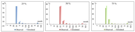
Figure 5.
Comparison of annual flow distribution periods as a percentage of the annual flow of the Zhabay River–Atbasar village.
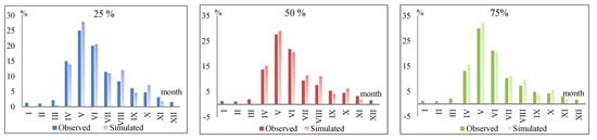
Figure 6.
Comparison of intra-annual flow distribution periods as a percentage of the annual flow of the Buktyrma River–Lesnaya Pristan village.
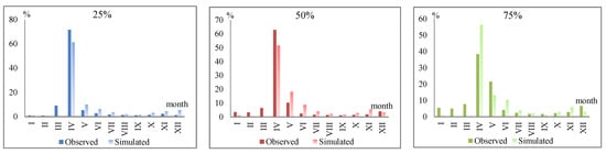
Figure 7.
Comparison of intra-annual flow distribution periods as a percentage of the annual flow of the Ulken Kobda River–Kobda village.
After analyzing Figure 5, it can be concluded that the largest flow of the Zhabay River is during the spring flood from 63.5 to 79.2% of the annual flow, and the smallest flow, less than 1%, is during the winter low water.
For the stream flow measuring station of the Buktyrma River–Lesnaya Pristan village, the results of the water content distribution are presented in Figure 6.
For the mountain Buktyrma River, the flood period extends from April to August, and the largest flow occurs in May, from 25 to 30%. Also, the contribution of flow in April is significant and makes up from 20 to 21.2%.
For the stream flow measuring station of Ulken Kobda River–Kobda village, the results of the water content distribution are presented in Figure 7.
According to the estimated data of the intra-annual distribution, the largest flow of the Ulken Kobda River takes place during the spring flood, 38.4% of the flow for the low-water year (75% of availability), and 71.6% of the flow for the high-water year (25% of availability).
Comparative analysis of the actual runoff, which already reflects the impact of climate change, and the conditionally natural runoff (modelled) reveals the following trends:
- -
- for the Zhabay River, the modern spring maximum has decreased, which is due to increased air temperature and increased infiltration of meltwater into the soil. There is also a slight increase in winter runoff due to changes in the soil freezing regime and an increase in the frequency of winter precipitation in the form of rain.
- -
- for the Buktyrma River, the present-day peak of floods is shifted to later dates. Under present-day conditions, May discharges are decreasing and June discharges are increasing;
- -
- for the Ulken Kobda River, if in conditionally-natural flow conditions the flow was redistributed more evenly during the year, then in modern conditions the most share of the water is concentrated during the short period—the spring high water. A decrease in summer flow is also recorded, which indicates a decrease in summer precipitation.
Several scientific studies have assessed changes in the hydrological regime of rivers in Kazakhstan, yielding results similar to the above analysis while also revealing some differences. For instance, the study “Central Asian rivers under climate change: Impacts assessed in eight representative catchments” [2] examines changes in the hydrological regime of rivers across Central Asia, including Kazakhstan. This study confirms trends such as a decrease in the proportion of spring floods and an increase in winter flows, which are characteristic of rivers such as the Zhabay, Buktyrma, and Ulken-Kobda. However, despite these similarities, the authors also note that for mountain rivers like the Buktyrma, peak flows may shift not only to later dates but may also increase during the summer months. This difference could be attributed to variations in the modeling methods and climate data employed in both studies. Changes in flow are also observed in the study “Impact of climate change and anthropogenic factors on the runoff of the Ertis River” [1], which analyzes changes in the water regime of the Irtysh River, incorporating various types of river feeding. This study emphasizes glacial and rainfall feeding, rather than snow feeding, leading to an increase in winter runoff and the stabilization of water availability in specific years, contrasting with the continuous rise in winter runoff in the considered basins. Finally, the study “Restoration of spring runoff series of the rivers of the Zhaiyk-Caspian basin” [25] confirms that changes in runoff distribution associated with climatic factors follow similar trends: a decrease in spring runoff and an increase in winter runoff. However, for rivers like the Zhaiyk, the influence of atmospheric circulation during different phases of water availability plays a significant role. This confirms the observed patterns for rivers with varying types of feeding, such as Buktyrma and Ulken-Kobda.
Thus, despite certain differences, all the studies reviewed corroborate the general trends in changes to the hydrological regime of Kazakhstan’s rivers, particularly the reduction in spring runoff and the increase in winter runoff under climate change conditions. The observed differences, such as the shift of runoff peaks to later dates or the increase in summer runoff, can likely be explained by variations in the types of river feeding, their geographical locations, and the modeling methods used in the studies.
Influence of atmospheric circulation on intra-annual runoff distribution.
The direction of the predominant transport of air masses, reflected by the identified forms of atmospheric macrocirculation, also determines the hydrological features of specific years. This work compares the forms of atmospheric macrocirculation with the annual flow of the Zhabay, Buktyrma, and Ulken Kobda rivers. Data on the predominance of forms of atmospheric macrocirculation are taken from the catalog of relevant indices, which is continuously maintained at the Arctic and Antarctic Research Institute [45].
Average modular flow coefficients K (relative to the average flow value over a long-term period) by epochs of atmospheric macrocirculation were calculated for the studied rivers (Table 7).
Table 7.
Average modular annual flow ratios for atmospheric circulation epochs (W—западная, E—восточная, C—меридиональная).
The largest flow for the Zhabay River–Atbasar village is noted in the E epoch, in which the modular coefficient is 1.61. The smallest flow occurs in the E + C epoch and is 0.58. For the Buktyrma and Ulken Kobda rivers, focusing on modular flow data for various circulation epochs, it can be concluded that the W epoch gives an increased flow, and the E epoch also provides mainly slightly increased flow.
Thus, the largest flow was observed with type C, and reduced flow with type E. It is required to analyze specific years with high and low river water content. In each specific section, the five highest and lowest water years were considered (Table 8 and Table 9).
Table 8.
Types of circulation in the most high-water years.
Table 9.
Types of circulation in the lowest water years.
High water years. For all rivers, most high-water years are characterized by increased recurrence of type E, with the exception of 1997, 1998, 2015, and 2017 with type W, and 2002 with type E + W.
Low-water years. To characterize the formation conditions, five years were also used for each hydrological point. For all rivers, most low-water years are characterized by increased recurrence of types W and E, respectively 7 and 8 in number of recurrences.
Thus, general patterns associated with the repeatability of forms of macrocirculation exist, but this indicator does not fully reflect hydrological trends. Furthermore, more detailed studies are needed to determine certain forms of atmospheric circulation and their impact on the hydrological regime.
4. Conclusions
The impact of climatic factors on the hydrological cycle covers all spatial scales from regional to global. In recent decades, the global hydrological cycle has already been responding to observed global warming, which includes rising air temperatures, increasing atmospheric humidity, and changing global amount of precipitation. In many regions, changing precipitation patterns or melting snow and ice are changing hydrological systems, affecting water resources in terms of quantity and quality [46,47].
The study showed that the intra-regional distribution of the river flow of Buktyrma, Zhabay, and Ulken Kobda rivers changes significantly under the influence of climatic factors and atmospheric circulation. The main trends include a decrease in spring flow of the Zhabay River, a shift in the peak of the high water for a later date for the Buktyrma River, and strengthening of the seasonal flow concentration of the Ulken Kobda River. These changes are due to an increase in air temperature, a change in precipitation, and infiltration.
The circulation of the atmosphere plays an important role in the formation. The western type of circulation helps to increase the water content of the Buktyrma and Ulken Kobda rivers, and the eastern type is associated with high-water years. The analysis showed that atmospheric processes have a significant impact on the hydrological characteristics of the studied rivers. For all rivers, the most high-water years are characterized by increased repeatability of type E, with the exception of 1997, 1998, 2015, and 2017 with type W, and 2002 with type E + W. In low-water years, five years for each stream flow measuring station were also used to characterize the formation conditions. For all rivers, most low-water years are characterized by increased recurrence of types W and E, respectively 7 and 8 in number of recurrences.
The assembly method according to V.G. Andreyanov demonstrated the greatest effectiveness in the analysis of the intra-regional distribution of the flow of plain rivers with predominant snow nutrition. Comparison of the modelled (conditionally-natural) and actual (modern) flow revealed key changes associated with climatic factors.
Several limitations and potential uncertainties that may influence the results of this study should be acknowledged. One such limitation is the uncertainty associated with the use of hydrological models to estimate river flows. Despite employing modern modeling techniques, uncertainties may arise due to the quality of input data, such as the accuracy of climate forecasts or the data on snow cover and precipitation. These uncertainties could impact the accuracy of the modeled results. Furthermore, the study did not fully address the potential effects of anthropogenic activities, such as alterations in the water regime due to reservoir construction, flow regulation, and other factors. Additionally, human activities, such as changes in land use and water body pollution, may significantly influence the river’s water regime. Considering these factors in future research will help improve the accuracy of the assessment of changes in the hydrological regime of Kazakhstan’s rivers.
Thus, taking into account the identified trends in changes in flow distribution, it is important not only to predict changes in flow distribution but also to suggest directions for future water resources management and policy development. First and foremost, water supply and water use strategies need to be adapted to account for later flood peaks and increased winter flows. Forecasts of flow changes can help form better-informed decisions on reservoir management, irrigation of agricultural land, and flood risk reduction. Additionally, based on the data obtained, it is recommended to develop effective water management mechanisms that take into account changes in seasonal flow fluctuations, as well as to introduce monitoring systems that enable timely responses to changes in the hydrological regime of rivers. This will help increase the resilience of the water sector to the effects of climate change and ensure a more balanced and rational use of water resources in the future.
The study provides important information for water management policy formulation and adaptation to climate change, which is a key aspect of ensuring a sustainable water supply in a changing climate.
Author Contributions
Conceptualization, A.N.; methodology, A.N. and A.T.; software, A.N.; formal analysis, Z.S., A.N. and F.H.; data curation, Z.S.; investigation, A.N. and Z.S.; resources, Z.S.; writing-original draft preparation, A.N. and F.H.; writing-review and editing, A.N.; visualization, A.N. and Z.S.; supervision, A.T. and A.N.; project administration, A.T. All authors have read and agreed to the published version of the manuscript.
Funding
This research has been funded by the Committee of Science of the Ministry of Science and Higher Education of the Republic of Kazakhstan (Grant No. AP19678734 ‘Assessment of the current and predicted hydrological changes of Kazakhstan river basins based on modeling’ (ex., Buktyrma, Esil, Zhaiyk rivers)).
Institutional Review Board Statement
Not applicable.
Informed Consent Statement
Not applicable.
Data Availability Statement
Data are contained within the article.
Acknowledgments
We thank the Integrated Natural Resource Management and Climate Change Expert Rieks Bosch, GIZ Climate Risk Assessment for Central Asia.
Conflicts of Interest
The authors declare no conflicts of interest.
References
- Baspakova, G.R.; Alimkulov, S.K.; Sarkynov, E.S.; Saparova, A.A.; Kulebayev, K.M. Impact of climate change and anthropogenic factors on the runoff of the Ertis River. News Natl. Acad. Sci. Repub. Kazakhstan Ser. Geol. Tech. Sci. 2022, 2022, 6–22. [Google Scholar]
- Didovets, I.; Lobanova, A.; Krysanova, V.; Menz, C.; Babagalieva, Z.; Nurbatsina, A.; Gavrilenko, N.; Khamidov, V.; Umirbekov, A.; Qodirov, S.; et al. Central Asian rivers under climate change: Impacts assessment in eight representative catchments. J. Hydrol. Reg. Stud. 2021, 34, 100779. [Google Scholar] [CrossRef]
- Didovets, I.; Krysanova, V.; Nurbatsina, A.; Fallah, B.; Krylova, V.; Saparova, A.; Niyazov, J.; Kalashnikova, O.; Hattermann, F.F. Attribution of current trends in streamflow to climate change for 12 Central Asian catchments. Clim. Change 2024, 177, 16. [Google Scholar] [CrossRef]
- Smagulov, Z.; Snow, D.; Arystambekova, D.; Sailaubek, A.; Tairov, A. Study of water regime of Zhaiyk transboundary river in the context of anthropogenic and climatic changes. News Natl. Acad. Sci. Repub. Kazakhstan Ser. Geol. Tech. Sci. 2024, 2024, 164–178. [Google Scholar]
- Mittal, N.; Mishra, A.; Singh, R. Flow regime alteration due to anthropogenic and climatic changes in the Kangsabati River, India. Ecohydrol. Hydrobiol. 2014, 14, 182–191. [Google Scholar] [CrossRef]
- Jiang, C.; Xiong, L.; Wang, D.; Liu, P. Separating the impacts of climate change and human activities on runoff using the Budyko-type equations with time-varying parameters. J. Hydrol. 2015, 522, 326–338. [Google Scholar] [CrossRef]
- Vörösmarty, C.J.; Green, P.; Salisbury, J.; Lammers, R.B. Global water resources: Vulnerability from climate change and population growth. Science 2000, 289, 284–288. [Google Scholar] [CrossRef] [PubMed]
- Georgiadi, A.G.; Koronkevich, N.I.; Barabanova, E.A. On the contribution of climatic and anthropogenic factors in changes in the runoff of large rivers of the Russian Plain and Siberia. Rep. Acad. Sci. Nauka Publ. House 2005, 488, 539–544. [Google Scholar]
- Kazhydromet. Annual Bulletin of Monitoring of Climate Change and Condition of Kazakhstan: 2015; Kazhydromet: Astana, Kazakhstan, 2016. [Google Scholar]
- Beldeubaev, E.; Smirnova, E.; Dolgikh, S. Approaches and results of assessment of probable climate change in Kazakhstan. In CITES’2019; Kazhydromet: Astana, Kazakhstan, 2019; pp. 320–323. [Google Scholar]
- Cui, T.; Tian, F.; Yang, T.; Wen, J.; Khan, M.Y.A. Development of a comprehensive framework for assessing the impacts of climate change and dam construction on flow regimes. J. Hydrol. 2020, 590, 125358. [Google Scholar] [CrossRef]
- Korneychuk, N.N.; Kirichuk, G.Y. Structural and functional organization of phytomicroperiphyton of the transboundary Stviga River. Hydrobiol. J. 2018, 54, 3–18. [Google Scholar] [CrossRef]
- Kuzin, P.S. Regime of Rivers of Southern Regions of Western Siberia, Northern and Central Kazakhstan; Gidrometeoizdat: Leningrad, Russia, 1953. [Google Scholar]
- Skotselyas, N.I. Calculation of intra-annual runoff distribution for unstudied rivers of the Altai Mountains. Proc. KazNIGMI 1975, 15–20. [Google Scholar]
- Berkaliev, Z.T. Hydrological Regime of Rivers of Central, Northern and Western Kazakhstan; Academy of Sciences of Kaz SSR: Almaty, Kazakhstan, 1959. [Google Scholar]
- Galperin, R.I. (Ed.) Renewable Resources of Surface Water in the South and South-East of Kazakhstan. Renewable Resources of Surface Waters of Western, Northern and Central and Eastern Kazakhstan; Institute of Geography and Water Security: Almaty, Kazakhstan, 2012; Volume VII, Book 1. [Google Scholar]
- Dostai, J.D.; Alimkulov, S.K.; Saparova, A.A. River Runoff Resources. Renewable Resources of Surface Water in the South and South-East of Kazakhstan. Renewable Resources of Surface Waters of Western, Northern and Central and Eastern Kazakhstan; Institute of Geography and Water Security: Almaty, Kazakhstan, 2012; Volume VII, Book 2. [Google Scholar]
- Davletgaliev, S.K. Cumulative assessment of the norm of monthly runoff of the rivers of Northern and Western Dzungaria. Bull. KazSU Geogr. Ser. 1996, 3, 99–109. [Google Scholar]
- Chigrinets, A.G. Intra-annual distribution of runoff of right-bank tributaries of the river Ertis within the Republic of Kazakhstan. Bull. KazNU Ser. Geogr. 2012, 1, 54–63. [Google Scholar]
- Tursunova, A.A.; Myrzakhmetov, A.B.; Kurkebaev, A.A. Intra-annual distribution of river runoff in the basin of Lake Balkash. Hydrometeorol. Ecol. 2010, 4, 118–129. [Google Scholar]
- Chigrinets, A.G.; Duskaev, K.K.; Satmurzaev, A.A.; Insigenova, A.E.; Salavatova, J.T. Study of the main characteristics and intra-annual distribution of water flow in the rivers of the territory of Almaty. Hydrometeorol. Ecol. 2021, 3, 44–62. [Google Scholar]
- Alimkulov, S.K.; Raimbekova, J.T.; Isaldaeva, S.J. Assessment of intra-annual distribution of river runoff of the Northern slope of Zhetysu Alatau. Bull. KazNU Ser. Geogr. 2022, 1, 70–76. [Google Scholar]
- Tursunova, A.A.; Appazova, T.B.; Talipova, E.K. Assessment of the intra-annual distribution of river runoff of the Ertis River basin. In International Scientific and Practical Conference “Prospects for the Development of Modern Science”; Regional Academy of Management: Jerusalem, Israel, 2016; pp. 262–269. [Google Scholar]
- Kulebaev, K.M. Intra-annual distribution of river runoff in the Shu, Talas basin. Vopr. Geogr. I Geoekologii 2013, 2, 52–55. [Google Scholar]
- Davletgaliev, S.K.; Dostaeva, A.D. Restoration of spring runoff series of the rivers of the Zhaiyk-Caspian basin. Hydrometeorol. Ecol. 2014, 1, 88–95. [Google Scholar]
- Temirbayeva, R.K.; Akiyanova, F.Z.; Orazbekova, K.S.; Veysov, S.K. Socio-economic aspects of nature management in Kazakhstan’s Caspian Sea region based on functional zoning of the territory. Ser. Geol. Tech. Sci. 2020, 1, 131–137. [Google Scholar] [CrossRef]
- Yegemberdiyeva, K.; Yushina, Y.; Khen, A.; Temirbayeva, R.; Orazbekova, K. Assessment of the natural-recreational resources of the Akmola region (based on the example of the Shchuchinsk-Borovoye resort area) for the purpose of sustainable development of tourism. Geo J. Tour. Geosites 2020, 30, 818–826. [Google Scholar]
- Shivareva, S.P.; Avezova, A. Water resources of Kazakhstan: State and water management. J. Hydrol. Ecol. 2012, 7, 58–64. [Google Scholar]
- Shivareva, S.P.; Avezova, A. Application of the HBV model for calculating the Oba River runoff for the future taking into account climate change. Hydrometeorol. Ecol. 2012, 4, 66–77. [Google Scholar]
- Zhensikbayeva, N.; Saparov, K.; Kabdrakhmanova, N.; Atasoy, E.; Yeginbayeva, A.; Abzeleeva, K.; Bakin, S.; Sedelev, V.; Amangeldy, N. An assessment of the construction and hydrographic conditions of Bukhtarma and Ust-Kamenogorsk reservoirs in the East Kazakhstan region for 2017–2021. Sustainability 2024, 16, 10348. [Google Scholar] [CrossRef]
- Makhmudova, L.; Moldakhmetov, M.; Mussina, A.; Kurmangazy, E.; Kambarbekov, G.; Zharylkassyn, A.; Zhulkainarova, M. Study of Water Stress in Plains Rivers: Climate and Human Influence. Evergreen 2024, 11, 1530–1543. [Google Scholar] [CrossRef]
- Alimkulov, S.; Tursunova, A.; Saparova, A.; Kulebaev, K.; Zagidullina, A.; Myrzahmetov, A. Resources of river runoff of Kazakhstan. Int. J. Eng. Adv. Technol. 2019, 8, 2242–2250. [Google Scholar]
- SP 33-101-2003; Determination of Calculated Hydrological Characteristics. Gosstroy of Russia: Moscow, Russia, 2004.
- SNiP 2.01.14-83; Definitions of Design Hydrological Characteristics. Gosstroy of the USSR: Moscow, Russia, 1985.
- Andreyanov, V.G. Intra-Annual Distribution of Runoff; Gidrometeoizdat: Leningrad, Russia, 1960. [Google Scholar]
- Krysanova, V.; Hattermann, F.; Wechsung, F. Development of the Ecohydrological Model SWIM for Regional Impact Studies and Vulnerability Assessment. Hydrol. Process. 2005, 19, 763–783. [Google Scholar] [CrossRef]
- Gao, C.; Yao, M.T.; Wang, Y.J.; Zhai, J.Q.; Buda, S.; Fischer, T.; Zeng, X.F.; Wang, W.P. Hydrological model comparison and assessment: Criteria from catchment scales and temporal resolution. Hydrol. Sci. J. 2015, 60, 1057–1074. [Google Scholar] [CrossRef]
- Conradt, T.; Wechsung, F.; Bronstert, A. Three perceptions of the evapotranspiration landscape: Comparing spatial patterns from a distributed hydrological model, remotely sensed surface temperatures, and sub-basin water balances. Hydrol. Earth Syst. Sci. 2013, 17, 2947–2962. [Google Scholar]
- Nurbatsina, A.; Salavatova, Z.; Tursunova, A.; Didovets, I.; Huthoff, F.; Rodrigo-Clavero, M.-E.; Rodrigo-Ilarri, J. Flood modelling of the Zhabay River basin under climate change conditions. Hydrology 2025, 12, 35. [Google Scholar] [CrossRef]
- Wangenheim-Geers Atmospheric Circulation Forms. Theory and Practice of the Methods of Typification of Atmospheric Processes. 2025. Available online: https://studentopedia.ru/geografiya/tipizaciya-form-atmosfernoj-cirkulyacii-vangengejma---girsa---teoriya-i-praktika-metodov.html (accessed on 9 January 2025).
- Girs, A.A. Many-Year Fluctuations of Atmospheric Circulation and Long-Term Hydrometeorological Forecasts; Gidrometeoizdat: Leningrad, Russia, 1971. [Google Scholar]
- Climate Change Risk and Vulnerability Assessment (CCRA). National Report for Kazakhstan; Climate Change Adaptation and Mitigation Program for the Aral Sea Basin (CAMP4ASB): Astana, Kazakhstan, 2020. [Google Scholar]
- Makhmudova, L.; Beisembin, K.; Moldakhmetov, M.; Mussina, A. Intra-annual flow distribution of the rivers in the Esil river basin. Water Conserv. Manag. 2024, 8, 241–250. [Google Scholar] [CrossRef]
- Baidal, M.H. Long-Term Weather Forecasts and Climate Fluctuations in Kazakhstan; Gidrometeoizdat: Leningrad, Russia, 1964; Volumes 1 and 2. [Google Scholar]
- Lahmer, W.; Pfützner, B.; Becker, A. Assessment of land use and climate change impacts on the mesoscale. Phys. Chem. Earth Part B Hydrol. Ocean. Atmos. 2001, 26, 565–575. [Google Scholar]
- Bates, B.C.; Kundzewicz, Z.W.; Wu, S.; Palutikof, J.P. Climate Change and Water, Technical Paper of the Intergovernmental Panel on Climate Change; IPCC Secretariat: Geneva, Switzerland, 2008. [Google Scholar]
- Jiménez Cisneros, B.E.; Oki, T.; Arnell, N.W. Freshwater resources. In Climate Change 2014: Impacts, Adaptation, and Vulnerability. Part A; Cambridge University Press: Cambridge, UK, 2014; pp. 229–269. [Google Scholar]
Disclaimer/Publisher’s Note: The statements, opinions and data contained in all publications are solely those of the individual author(s) and contributor(s) and not of MDPI and/or the editor(s). MDPI and/or the editor(s) disclaim responsibility for any injury to people or property resulting from any ideas, methods, instructions or products referred to in the content. |
© 2025 by the authors. Licensee MDPI, Basel, Switzerland. This article is an open access article distributed under the terms and conditions of the Creative Commons Attribution (CC BY) license (https://creativecommons.org/licenses/by/4.0/).