Article

Walkable and Sustainable City Centre Greenway Planning

by
Carlos J. L. Balsas
* and
Neale Blair
Belfast School of Architecture and the Built Environment, University of Ulster, Belfast BT15 1ED, UK
*
Author to whom correspondence should be addressed.
Sustainability 2025, 17(7), 2897; https://doi.org/10.3390/su17072897
Submission received: 15 February 2025 / Revised: 9 March 2025 / Accepted: 18 March 2025 / Published: 25 March 2025
(This article belongs to the Special Issue Green Infrastructure Systems in the Context of Urban Resilience)

Abstract

Walking has been studied extensively in recent years. However, one is still hard pressed to find research examining what makes urban settings of different sizes across the Atlantic Ocean conducive to walking, especially in the presence of greenways and green open spaces. Streets and urban greenways both enable flows. Streets are mostly utilized to enable the flow of motorized traffic and people while greenways aim to guarantee the flow of water, nature, biodiversity, and people. Streets are designed to artificially separate motorized traffic from pedestrians, greenways are designed to create the natural conditions for a harmonious co-existence of people with nature. How would street users benefit from streetscape and urban design improvements aimed at promoting the peaceful, silent, and harmonious co-existence of nature, people, and vehicles? Distinct sets of codes and norms dictate how individuals ought to utilize urban public spaces and greenways. We argue that said codes ought to also be aimed at increasing the quality of public spaces and not only their flow capacities. This paper examines streets and greenways in Ballyclare, Leiria, and Scottsdale. We utilize Ballyclare’s High Street and Six Mile Water greenway, Leiria’s city centre and Lis River greenway, as well as Scottsdale Road and the Indian Bend Wash greenbelt and a segment of the Arizona Canal to analyse the positive characteristics and shortcomings of successful streets and greenway systems in three distinct geographic contexts: U.K., Southern European, and North American. The findings comprise the distillation of new results in the analysis of spaces of flows and permanence across the Atlantic Ocean.

Graphical Abstract

1. Introduction

Urbanization is increasingly shaped by a growing number of canonical and colonial codes (e.g., laws, regulations, plans, and norms). Some deal with streets [1,2], others with the placement of buildings, open spaces, setbacks, buffer zones, and greenbelts [1,3,4], others yet have developed according to specific cultural and geostrategic patterns (e.g., Spanish Law of the Indies [5] or Portuguese urbanistic grammars [6]), while more recently, we seem to appear increasingly concerned with urban design and placemaking practices [7]. However, urbanization also evolves according to socio-economic, cultural, and environmental priorities. After decades of designing streets and roads to accommodate mostly motorized traffic, emphasis has shifted recently to also accommodating soft modes of transport in conjunction with attempts at encouraging individuals to patronize improved urban places and green open spaces.
The types of street improvements implemented in recent years range the gamut from basic streetscape improvements and the replacement of pavements to complete street interventions involving the widening of sidewalks, the redesigning of public spaces to limit vehicular parking, the installation of traffic calming measures, to fully closed walk-only precincts. Placemaking is central to many of these improvements, which result in safer, more pleasant, comfortable, attractive, and healthier climatic conditions for pedestrians, such as shade canopies and structures [8]. Higher degrees of safety and permeability between streets and their adjacent built environments have resulted partially from building arcades, access alleyways, and a variety of traffic calming devices such as bulb-outs, raised crosswalks, and speed tables. A recent trend in street design and placemaking improvements has been the emphasis on incorporating greenery, landscaping, and green and blue infrastructure aimed mostly at increasing walking and cycling and at creating an environment more conducive to shopping [9]. Green open spaces, green and blue infrastructure, and greenways are becoming important landscape ecology strategies in street and ecological networks in consolidated urban areas.
This paper attempts to answer three main research questions: To what extent are cities and towns relying on transportation improvements to create more walkable and vibrant neighbourhoods, especially in city centres? In cities located adjacent to or transversed by rivers and canals, are municipalities bringing together the benefits provided by walk-only precincts with those enabled by waterfront greenways? If yes, how are they doing it and what lessons can be learned by examining case studies in distinct geographical contexts such as the U.K., Southern Europe, and the United States?
This paper’s purpose is to answer these questions with an analysis of three case studies in different demographic, morphological, and geographical contexts: (i) a Northern Irish (U.K.) small market town in the countryside, (ii) a Portuguese coastal castle town, and (iii) a spread-out city on the edge of a U.S. large sunbelt metropolis in the southwest of the country (Figure 1). The study comprises three sub-objectives: (i) to study how revised codes have led to changes in the urban morphology of cities and their street and open space networks, (ii) to analyse the reasons for embracing sustainable mobility options conducive to more humane and less-machine-like behaviours, and (iii) to discuss the socio-ecological advantages and pitfalls of the selected regenerated city centre districts.
The field of sustainable transportation is vast, and its scholarship appears to grow exponentially by the day. According to [10], the most important travel demand variables are density, land-use diversity, pedestrian-oriented design, distance to transit, and destination accessibility. With three of these five variables, Dovey and Pafka developed an urban DMA index to analyse walkability in Manhattan and concluded that walking results from a complex synergy of density, mix, and access, where reductions in one variable influence the other two, resulting in tenuous oscillations in actual levels of walking [11].
Despite an earlier study of walk-only precincts in Asia, Europe, and North America, a recent bibliometric analysis of international methods and local factors claimed that systematic classifications and comparisons are still lacking [12]. The walk-only precincts study analysed three pairwise locations in only small and large cities in China, Portugal, and the United States. It concluded that city size was the variable responsible for the main differences in the comparative analysis of the eight tenets of the commercial revitalization vibrancy (CRV) theory. More recently, a comparative analysis of riverfront greenways in central Portugal and Arizona revealed key economic, environmental, community, and governance implications for the development of sustainable cities [13].
This study seeks to fill two main gaps in the authors’ earlier research by (i) incorporating an intermediate typology (i.e., the medium-sized city, simply an intermediate level between small and large cities) and (ii) combining waterfront greenway amenities built along longitudinal and curvilinear riverfronts (i.e., multi-use trails, fitness and exercise areas, playgrounds, and sports fields) with those aimed at also capitalizing on human-built water supply and irrigation canals, such as: dense urbanization, waterfront promenades, pocket parks, and pedestrian bridges.
This study is significant because it brings attention to three separate literature strands on city centre regeneration: (i) codes and norms, (ii) vitality and vibrancy, and (iii) riverfront greenways, open spaces, and biophilia in three distinct geographical contexts (Northern Ireland, U.K.; central Portugal; and the southwest U.S.). The findings result from the reconceptualization of the original “CRV theory” to account for the existence of greenways and waterways in its reformulated stance as the socio-ecological commercial revitalization vibrancy (Eco-CRV) theory. This change is justified since many municipalities with city centres transversed or bordered by greenways have been investing in the regeneration of their waterfronts and natural (and constructed) amenities to increase their urbanity, vibrancy, health, and quality of urban life.

2. Analytical Mechanism

2.1. Codes and Norms

Codes and norms influence the appearance and development of cities and towns. According to Fahimi et al., places are shaped by customized interactions between a “code” (conceptual framework) and a “place” (contextual framework) [14]. Furthermore, a detailed analysis of each place’s location, evolution, chronology, typology, scale, and fit can pivot major commonalities and differences. Obviously, Northern Ireland, Portugal, and the U.S. have distinct planning cultures and traditions (i.e., British, Napoleonic, and Constitutional capitalist economy, respectively).
In Northern Ireland, national planning policies shape the making of local development plans, while development planning decisions are made by local government politicians based on recommendations from planning professionals. In Portugal, a hierarchy of plans and various sectoral programs stipulate the type and location of new development and improvements to existing neighbourhoods. In the United States, depending on whether a state is considered a home rule state or not, local jurisdictions will have distinct discretion levels in the approval of development projects.
Nonetheless, the materialization of distinct codes and norms led to two main communalities across the Atlantic Ocean. First, the suburbanization of cities has encouraged households to own and utilize automobiles for their regular commuting and shopping needs [15,16]. And second, a return to the city trend since the mid-2000s has promoted higher levels of city living, improved public transport networks, and more effective micromobility solutions, including walking, cycling, and the use of scooters.
Urban growth motivated mostly by land development and new transportation systems has resulted in the suburbanization of territories, urban leap-frog, and suburban sprawl. New roads and motorways have facilitated vehicular travel while contributing to congestion and other negative environmental externalities. Nonetheless and in general terms, the rise of automobile ownership in Europe occurred slightly later than in the United States. Although large cities tend to be endowed with good public transport networks, smaller and medium size cities tend to be more compact, which enables higher levels of walking and cycling.
The development and growth of administrative codes and sectorial policies as well as more thorough public scrutiny over the planning and design of new development projects have contributed to additional obstacles in their approval and construction (i.e., more institutions with additional requirements to consider during the review processes) [17,18]. In the U.S., Euclidean zoning codes have been partially replaced by form-based codes, which attempt to augment the desirable characteristics of the built environment (urban form, compact development, and walkability) [19,20]. Many street networks have been partially redesigned under Complete Streets policies to help create authentic and vibrant urban places in cities [21].

2.2. Vitality and Vibrancy

Many high streets, main streets, and city centres have received increasing attention on both sides of the Atlantic Ocean [22,23]. Liveability and higher quality of life have been the result of conscious investments in the upgrading of urban environments via public and private investments. Municipal investments in the public realm have resulted in wider sidewalks, universal design improvements, and ADA accessible public spaces, which in certain cases have contributed to stimulating private investments in the adjacent urban fabric. Vitality and vibrancy have contributed to higher degrees of liveability [24,25].
Smart Cities approaches to urban living, including data collection and monitoring, have resulted in enhanced knowledge about the urban realm, city lifestyles, entertainment and recreational opportunities, and the development of the night-time economy. Higher levels of technological connectivity have also contributed to new business models and the globalization of supply chains [26]. Furthermore, cosmopolitan lifestyles have resulted in healthier active living habits and behaviours in parallel with an appreciation for vernacular architecture, urban conservation, and participation in environmental activities [27].
For more than two decades, walkability has become an increasingly common policy goal and objective in city centre regeneration interventions [24]. Walking can be analysed according to a “hierarchy of walking needs” ranging from the most essential to accessory: feasibility, accessibility, safety, comfort, and pleasurability [28]. The rise in green open spaces and greenway planning tend to enhance both the comfort and pleasurability aspects of walking. Nonetheless, many city centres are still negatively impacted by excessive motorization levels caused by little regulated vehicular circulation, traffic congestion, abusive parking, air and noise pollution, and unsafe and uncomfortable public spaces for pedestrians, mobility impaired individuals, children, and the elderly population.
Shuttleworth and Feehan, in a longitudinal study of active transport and journeys to work in Northern Ireland, concluded that the car is still the preferred mode of transport and that “policy interventions to encourage the use of healthy and sustainable modes of travel to work have encountered varying levels of success” [29] (p. 19). In Portugal, there has been a significant increase in the rate of motorization of the population from 455 vehicles per thousand inhabitants in 2008 to 579 in 2017, and an increase in the utilization of automobiles for regular trips from 46% of all commuting trips in 2001 to 62% in 2011 [30]. The United States experienced a temporary reduction in vehicle miles travelled (VMT) right after the global financial crisis of 2008–2010, but the trend toward motorization is still one of the country’s main hallmarks, even if now it is transitioning to one comprising hybrid and autonomous vehicles.
Within the context of suburban growth, we are observing the densification of suburban cores via a myriad of land development and construction strategies, which are mostly aimed at increasing the vibrancy of suburban neighbourhood cores. The planning strategies involve mixed-use developments, new housing above retail stores within a main street urban village typology, walkable main streets, on-street parking, and proximity to leisure and shopping opportunities [31].

2.3. Riverfront Greenways

Urban rivers and canals have served various functions over the centuries [32]. From moving water, goods, and people, they now enable more constrained water flows as well as fishing, aquatic sports, physical exercise on their banks, walking and promenading, cycling, contemplation and mental health, community wellbeing, birdwatching, picnicking, and a myriad of other socio-ecological activities [33].
Riverine open spaces require proper infrastructure and adequate maintenance levels. Regular utilization, natural, and weather-related wear and tear tend to damage protective walls, fences, and multi-use trails along green and blue spaces. Rivers and canals also tend to cause barrier effects, which can be dissipated through the construction of bridges. Pedestrian and bicycle paths and bridges increase connectivity and accessibility to nature, while facilitating recreational opportunities [13,34].
In the past, a history of vandalism and misappropriation of natural spaces led municipalities to abandon or cover up segments of urban rivers. Growing awareness about the advantages of green spaces and ecosystem services provided by natural systems has resulted in the daylighting of rivers and creeks, their decontamination and clean up, and the collective embracing of natural spaces by environmental, educational, and civic groups. Biophilia, health and wellbeing, biodiversity and rewilding, and healing and restorative lifestyles and practices have been followed by “think global—act locally”, urban agriculture, community gardens, and slow city movements [35].
Greenways are utilized to augment urban quality of life, property values, and to provide recreational opportunities. Greenways also serve to enhance biodiversity habitats, preserve scenic vistas and fragile land and cultural heritage resources, and constitute the basis of nature and park preserves, while connecting urban areas with the rural countryside.
Since their creation has not always been broadly supported or perceived as necessary as roadways and other infrastructure, quite often, greenways are relegated to a post-development phase when it is difficult to rearrange land uses, find space for their installation, and finance improvements [13]. As such, many greenways have been utilized in landscape urbanism retrofitting and urban regeneration strategies to capitalize on existing, often abandoned waterways, patches of urban forest, and urban green spaces such as urban lots and community gardens.
Zawawi et al. conducted a study on how greenways are being used for active transportation [36]. The authors’ review focused mostly on the characteristics, perceptions, and travel behaviours of active commuters on greenway corridors. It was discovered that greenway investments have had a small negligible impact on active transportation and that “differences in use were also affected by weather and temporal factors, greenways’ locations and characteristics, and contextual factors” [36] (p. 1).
Similar findings were arrived at by Vatanparast et al., who reported that a contemporary challenge associated with designed greenways pertains to their underutilization for active mobility, as not all of them are designed for daily mobility [37]. Despite these findings, Kwiatkowski and Karbowiński reported that green–blue linear corridors are increasingly being used as core elements of cycle and walking networks as the route’s location away from traffic and the natural character of its surroundings appear to be of greatest importance to users [34].

3. Materials and Methods

As clarified above, earlier research on walkability examined large and small city walk-only precincts. City size (small and quite large cities, e.g., Miami Beach and New York City) was the variable responsible for the main differences in the comparative analysis of the eight tenets of the commercial revitalization vibrancy (CRV) theory [24]. This study builds upon the Newman et al. theory of urban fabrics [38], which states that different types of cities are combinations of walking, transit/public transport, and automobile/motor car fabrics to illustrate differences in three urban archetypes (small market town, medium-sized city, and large and spread-out city): Archetype (urban fabric) I—the small walkable market town in Western Europe, Ballyclare, (with only one main street and with commuter bus-links to other towns in the countryside); Archetype (urban fabric) II—the medium-sized city with a centuries-old walkable city centre, Leiria, (in a municipality with various suburban centres and with its own city-wide bus system); and Archetype (urban fabric) III—a large and relatively young (less than 100 years old) spread-out southwestern U.S. city, Scottsdale, A.Z. (where walkable mid-range distances are feasible but not often done, served by a regional transit system and a local trolley to transport residents and visitors through the city centre), with extremely high car ownership and utilization rates (according to the 2023 American Community Survey of the U.S. Census, 68% of working households in Scottsdale drive to work (63% drive alone) and 27% work from home).
Of many possible selections and combinations of cities, the authors selected three cities they know well and have accompanied their evolution for long periods of time. As such, the sample selection is not arbitrary but deliberate. It is important to note that these three urban fabrics have parallels with the evolution of the genealogy of urban retail types from traditional markets (public and horse markets in Ballyclare), streets and plazas (such as in Leiria) through various adaptations and mutations into the contemporary shopping malls and power centres (easily found throughout the Phoenix metropolitan area) [39]. Furthermore, the case studies are influenced by their legal and jurisdictional contexts. Regional variations result from distinct relationships between socio-economic systems and their administration via laws, codes, policies, and politico-economic systems (i.e., less land, more compact development, more extensive urban planning in Europe and the reverse in the United States) [40].
This study is concerned mostly with two planning perspectives. First, more sustainable transportation planning and the encouragement of higher walkability levels through a myriad of strategies and, second, the rise in use of green urban spaces and waterways, such as riverine greenways and canals. Regarding the former, most cities feel the negative consequences of too much motorization daily. Frameworks, laws, plans, and codes aimed at encouraging more sustainable transport and safer walking and bicycling have been created at the international, national, state, and city level. E.U./U.K. and U.S. have developed specific orientations to reduce the negative consequences of growing automobile dependence. National orientations aimed at curtailing negative transport externalities in the two largest Portuguese metropolitan areas, such as the E.U.-mandated Sustainable Urban Mobility Plans (SUMPs), appear too detailed and exhaustive given their complex and multifaceted nature [41]. By analysing a threefold typology of small and walkable (Ballyclare), recently pedestrianized core of a mid-size city (Leiria), and one of the two walkable exceptions in the Phoenix metro area (Old Town Scottsdale), it is possible to focus specifically on the value and effectiveness of walkability improvements.
In terms of the second perspective, greenway planning received world-wide attention in the last four decades or so. In the U.K., including Northern Ireland, the National Cycling Network led to the construction of thousands of kilometres of bicycle and walking trails and paths. Exemplar cases in the Belfast metropolitan area are the waterfront trail along the Belfast Lough to the north of the city, and more recently, the Conswater Greenway through East Belfast [42,43]. In Portugal, connected greenway planning strategies were first proposed in the two main metropolitan areas of Lisbon and Porto (and then in the medium-sized cities of Coimbra, Setúbal, and Vila Franca de Xira) in the mid-1990s.
In the U.S., the greenway planning tradition can be traced to Frederick Law Olmstead’s “Emerald Neckless” landscape designs for Boston, Massachusetts. Said vision was moved forward by Ryan et al. for the New England and the whole northeast U.S. [44]. In Arizona, greenways gained popularity in the Phoenix metropolitan area due to efforts to regenerate an abandoned 17.7-kilometre ditch (which later became known as the Indian Bend Wash greenbelt running longitudinally through the city of Scottsdale), as well as Valley Forward’s proposal for the region’s nature preserves designated as “pedestrian freeway”, the 507-kilometre-long grand loop Maricopa trail [45], and the Canalscape initiative. The Canalscape initiative was aimed at promoting greater ecological value, higher connectivity, and recreational use of the 291 kilometres of man-made canals throughout the Phoenix metropolitan area [46,47].
The research design comprised an exploratory literature review, the identification of key policy documents, multiple study visits at different times and on different days and inventories, cartographic analysis, systematizations and triangulation of data from multiple sources. The research methods belong mostly to the qualitative and policy evaluation genre. The authors conducted multiple in-loco visits to the three cities at various occasions during the last twenty years (Ballyclare: 2004–2024; Leiria: 2023 and 2024; and Scottsdale: 2004–2014 and 2021). Other research techniques included visual documentation, analysis of urban regeneration interventions, commercial urbanism, walkability, and transportation plans, and an extensive literature review of specialized literature and media sources.
The Arizona case study has been partially researched in the context of an assistant professorship at Arizona State University (2004–2011), and subsequent self-funded studies of community planning, open space and greenway restoration, green gentrification, and large-scale regional socio-ecological systems. Although one of the authors has been familiar with Ballyclare’s marketplace functions and recent urban evolution for decades [48], acquaintance with the city’s latest main street improvements resulted from a study visit organized by staff at Ulster University in conjunction with Ulster University’s MSci Planning, Regeneration, and Development Module on Housing and Neighbourhoods in Spring 2024. The analysis of the Leiria case study started in conjunction with research on the construction of a new sports stadium for the UEFA European Football Championship EURO2004 in the mid-2000s, and most recently, due to one of the authors’ participation in the 2024 Annual Conference of the Portuguese Regional Development Association (APDR).
This study relies on an analysis of various urban regeneration, commercial urbanism, walkability, and transportation plans and regulations in the three case studies. Especially, Ballyclare’s 2019 Retail and Leisure Study and the 2022 Antrim and Newtownabbey Borough Council Integrated Masterplan, Leiria’s Municipal Master Plan (PDM), the 1999 Commercial Urbanism Global Study, the 2000–2005 POLIS Urban Regeneration Intervention, and the 2015 Urban Mobility Strategy, and Scottsdale’s General Plan, 2005 MAG Pedestrian Area Policies and Guidelines, 2006 Downtown Scottsdale Town Hall Workbook, and the 2022 Transportation Action Plan. Besides these planning documents, we also relied on timelines of the evolution of major urban regeneration projects and programs, recent walking visits to the city centres of Ballyclare and Leiria as well as virtual tours of Scottsdale via Google Earth Pro and Google Maps Streetview.
During the study visits, we conducted visual documentation of cityscapes, riverine environments, biodiversity, fauna and flora, and recreational and physical exercise opportunities. We also relied on prior informal meetings with planners in Scottsdale, Antrim and Newtownabbey Borough Council, and Leiria. We conducted extensive literature reviews of scholarly books and specialized scientific publications on Scopus, Web of Science, and Google Scholar as well as semi-systematic reviews of media sources (e.g., Ballyclare Gazette, Diário de Leiria, and East Valley Tribune). Finally, we utilize a health metaphor (i.e., the Basic Life Support or BLS) to discuss the relationships between the three urbanistic archetypes under consideration and their urban planning, urban regeneration, active living, physical health, and mental wellbeing implications [49,50].

4. Case Studies

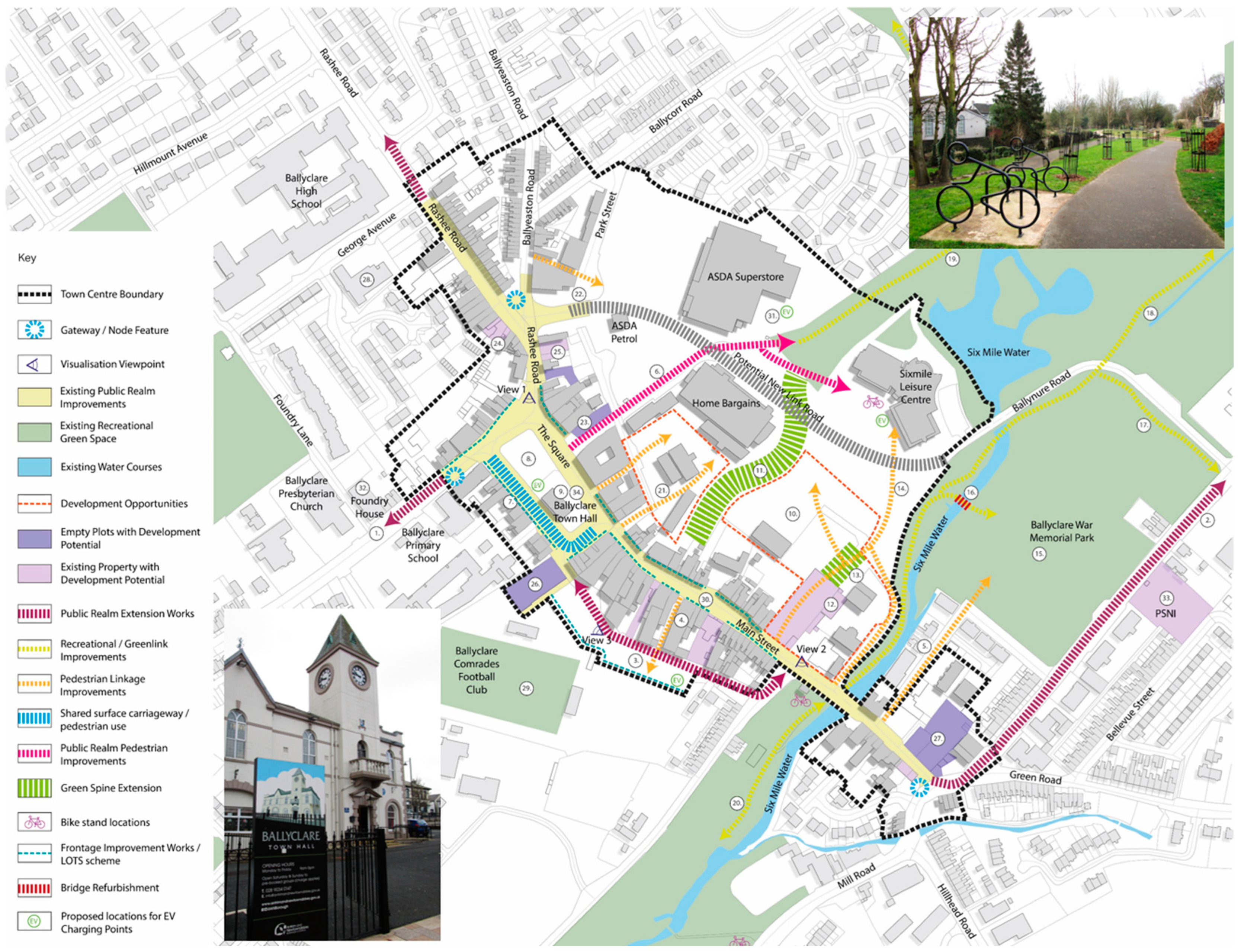
4.1. Ballyclare, Northern Ireland, U.K.

Ballyclare is a Northern Ireland market town of 19 thousand inhabitants in 2021 located in County Antrim and within Antrim and Newtownabbey Borough Council, about 21 kilometres northwest of Belfast [51]. The town has experienced considerable population growth over the last several decades (1999 in 1971). It is located on the Six Mile Water River crossing point and has a vast fertile rural hinterland, which enabled it to grow and prosper first from agricultural production and, at the turn of the 19th century, from industrial activity. Ballyclare’s Town Hall is located in Market Square in the centre of town (Figure 2). The building was developed out of an old market house. Markets have been critical to the town’s flourishing since the mid-eighteenth century [52]. Ballyclare’s May Fair is a weeklong festival of activities in early May, which dates back to when King George II granted permission to the town to hold two fairs each year [53].
The Main Street constitutes the town’s main linear spine, or high street independent establishments, and several rural roads and streets converge at Market Square, which causes some congestion. Three large retail stores with surface car parks are located on the northeastern edge of town not too distant from the town centre and near the town’s growing residential subdivisions. The town has recently conducted a Retail and Leisure Study (2019) and an Integrated Master Plan (2022). Partially because of these studies, Ballyclare implemented physical design improvements to its high street’s public realm. These comprised regularized sidewalk pavements, dropped kerbs, and pedestrian linkages to adjacent streets and off Main Streetcar parking facilities. It also upgraded a shared use path through the Six Mile Water River greenway, which guarantees enjoyable walking, running, and cycling, as a complement to near-by open-air sports and leisure activities (e.g., golf, football, birdwatching). Future improvements included in the 2022 Master Plan comprise, among others, removing the railings around the Town Hall grounds to augment the town’s civic identity and sense of place, additional alleyway pedestrian linkages, Shop Frontage improvements, and Live over Shop programs [55].

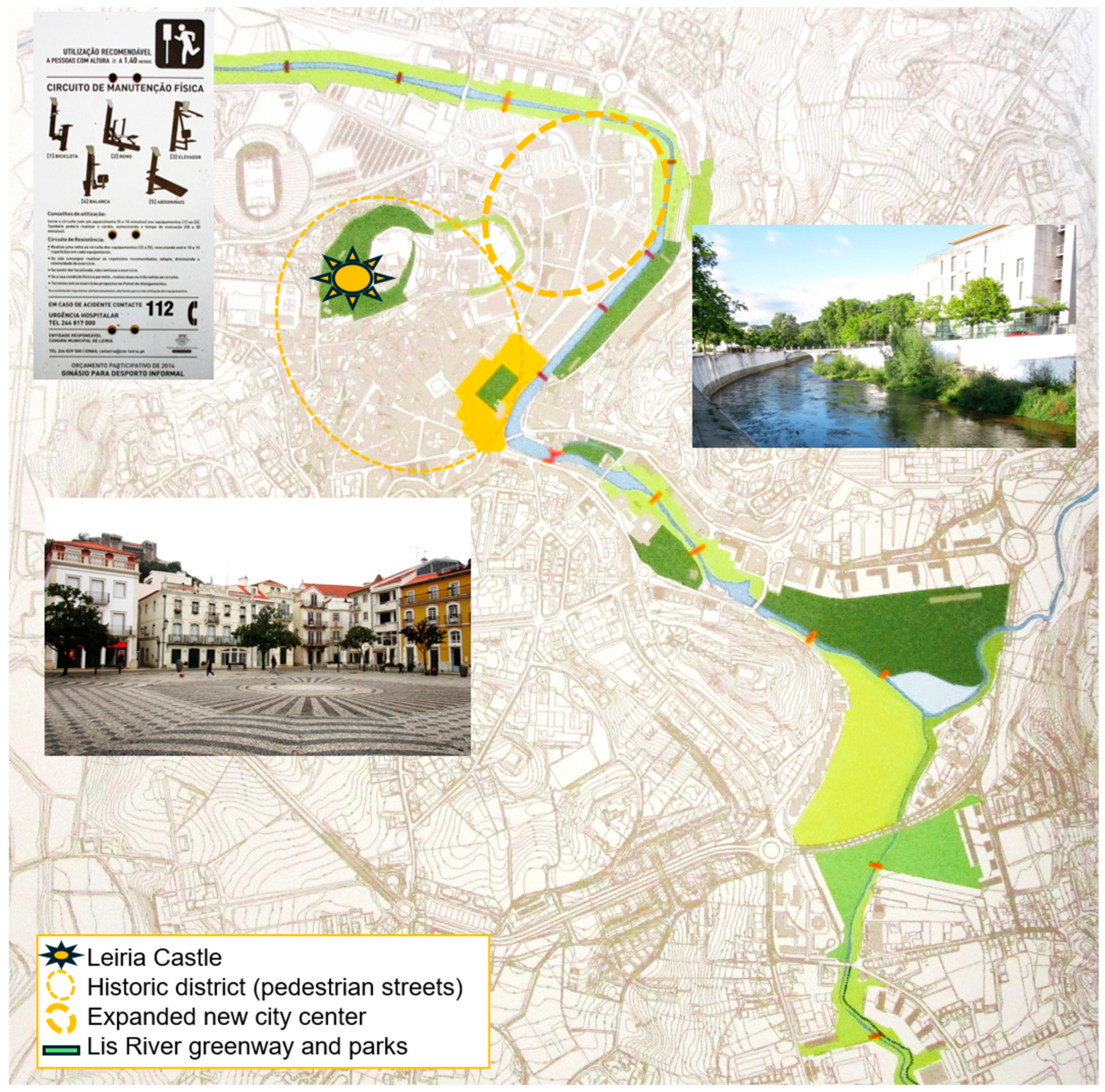
4.2. Leiria, Portugal

Leiria is a municipality in central Portugal with a population of 129 thousand inhabitants in 2021. The city has an extremely long history (Figure 3). The first King of Portugal, Afonso Henriques, re-captured it from the Moors in 1135.
The imponent hill overlooking the city was utilized for the construction of the castle, while its proximity to the river enabled water provision for domestic and irrigation purposes. The city’s historic district comprises extremely narrow streets, an old urban fabric with various retail establishments on the ground floor and housing above, public spaces such as plazas, mini-parks, open courtyards, the city’s cathedral, several administrative functions, and a public garden adjacent to the river [55].
The city experienced a very strong suburban growth during the 1990s due to developments in the industry and service sectors. This expansion was initially a result of the construction of modern avenues, such as the Av. Heróis de Angola and mixed used developments and shopping galleries, in a new centre adjacent to the centuries-old historic district. Said new expanded centre caters mostly to motorized traffic and more affluent shoppers. The continued expansion of educational and retail functions with the construction of the Polytechnic of Leiria and the regional shopping centre LeiriaShopping quite distant from the historic core in the 2000s led to the decline and closing of many independent retail establishments in the historic district.
The municipality has been actively attempting to promote the urban regeneration of the historic district for more than two decades. The most noteworthy initiatives consisted of improving city centre public spaces, pedestrianizing streets, modernizing traditional retail establishments, and catering to new touristic and entertainment activities such as specialized retail, bars, restaurants, arts and culture centres, museums, and art galleries [57].
Another important environmental regeneration project consisted of substantial improvements to a 7-kilometre corridor of the Lis River under the aegis of the POLIS program (2000–2005). The POLIS program utilized E.U. funding to improve the water body as well as the public spaces located on both banks of the river. It led to the construction of walking and bicycle multi-use trails, several pedestrian bridges, public parks, playgrounds, sports fields, and an integrated wayfinding system [58]. The most recent addition to the Lis River greenway was the construction of the pedestrian bridge El-Rei D. Dinis in 2013. The study visits in June 2024 revealed the high utilization of the improved riverine environments for walking and promenading, jogging, bicycling, physical exercising, gymnastics, and simply gaining respite from the busy daily activities, especially in the evenings and on weekends [59].

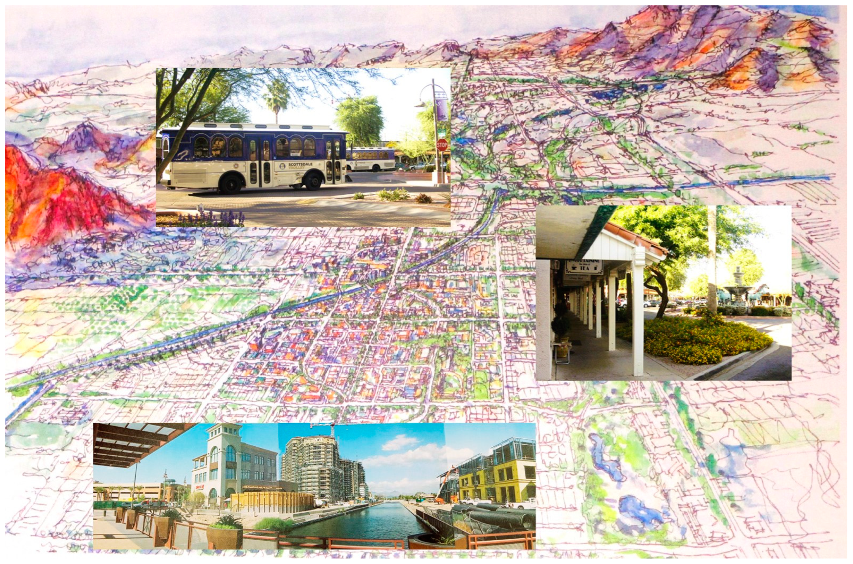
4.3. Scottsdale, AZ, U.S.

Scottsdale is a large city in the East Valley of the Phoenix metropolis (Figure 4). With an area of 477.8 square kilometres, Scottsdale is the 48th largest city in the U.S. Its population grew from 130,069 inhabitants in 1990 to 242,753 in 2021. The city is approximately 100 years old, having begun its existence as an agricultural town on Phoenix’s eastern edge. The city grew exponentially due to land development, high-tech industry, and more recently, employment in the tourism sector. Scottsdale is now a major touristic destination known for its high-class resorts, shopping malls, desert-style country living, and golf courses [60]. Scottsdale prides itself on being “the West’s Most Western Town” [61].
Like most southwestern sunbelt cities, Scottsdale has been laid out on a geometric grid-iron pattern. The city was built with the automobile as the main design element, which causes distances between places to be extremely far apart and requires private transportation to get around town. From a pedestrian planning perspective, this is alarming, as the Phoenix-Mesa-Scottsdale metropolitan area was ranked 16th on the list of the 20 most dangerous metro areas for pedestrians in the United States [62].
Downtown Scottsdale, which includes the city’s original settlement known as Old Town Scottsdale, now comprises five distinct urban districts (i.e., Old Town, Main Street Arts District, Fifth Avenue, Marshall Way, and Craftsman Court). One of the largest and most visited regional malls in the Phoenix metropolitan area, the Scottsdale Fashion Square Mall, is located on the northwest edge of downtown. Since the 1970s, downtown Scottsdale became known for its weekly art walks, annual Culinary Festivals, and the Scottsdale Center for the Arts, a key performing venue. The Scottsdale Cultural and Civic Center comprises the City Hall, museums, a performance venue and the city’s convention centre. East Main Street, located perpendicular to North Scottsdale Road, is downtown’s main walking spine separating the streets to the north from the avenues to the south. East Main Street connects the Civic Center Mall to the east with Old Town and the Arts District to the west.
Figure 4. Downtown Scottsdale and Indian Bend Wash Greenbelt ([63] and authors’ archive).
Sustainability 17 02897 g004
Due to competition from other retail and entertainment venues elsewhere in the city and the East Valley, downtown lost some of its appeal to residents during the 1980s and its viability was assured mostly by the regular weekend flow of visitors and tourists. To ease the flow of traffic on the major linear arterial road transversing the city and downtown longitudinally, North Scottsdale Road, the city built two bypasses on either side of its downtown (i.e., Goldwater Blvd and Drinkwater Blvd). It also enhanced surface parking lots, on-street, and multistorey car parks, as well as implemented a local trolley to facilitate residents’ and visitors’ trips through the area’s various sub-districts. It strengthened downtown’s identity by strategically exploiting synergies amongst the area’s eight clusters: retail/recreation, waterfront, entertainment, office, arts, old town, civic/cultural, and medical services.
The area’s specialized retail, many bars, pubs, and restaurants, as well as art galleries, and souvenir shops make downtown not a drive-through district but one marked by intensive cruising in the evenings and especially on weekends. Scottsdale has been actively searching for more effective ways to increase the area’s walkability, environmental amenities, attractiveness, and cachê. Also, in recent years, the municipality has attempted to implement a variety of projects aimed not only at keeping the specialized leisure and entertainment foci of the area, but also to increase the number of residents who live and work downtown.
Key projects completed recently, amounting to over an estimated USD 2 billion of investment, include a major anchor development, known as Scottsdale Waterfront, which comprises retail, office, and residential uses adjacent to the regional shopping mall, Scottsdale Fashion Square, and is right on the northern bank of the Arizona Canal [64]. This development enabled the strengthening of pedestrian connections between the two banks of the Arizona Canal without having to walk through the area’s busy thoroughfare, Scottsdale Road. The new pedestrian bridge designed by the famous Italian–American architect and Scottsdale resident, Paolo Soleri, created brand new public spaces at Arizona Canal and South Canal Plaza [46]. Besides this canal-centred greenway, the eastern edge of downtown is located two blocks away from the valley’s second largest and attractive longitudinal greenbelt amenity, the Indian Bend Wash greenbelt. This state-of-the-art greenway comprises abundant recreational opportunities with multi-use trails for jogging, bicycling, and roller-blading, as well as a series of parks, lakes, sports fields, and golf courses.

5. Comparative Analysis and Discussion

As stated above, the original “CRV theory” [24] was reconceptualized to account for the existence of greenways and waterways in its reformulated stance as the socio-ecological commercial revitalization vibrancy (Eco-CRV) theory. The eight tenets of the [reconceptualized and extended] Eco-CRV theory are now as follows: (i) the location of the streets [and environmental amenities] in the cities and the main reasons for their creation; (ii) the proportion of the pedestrian precincts [and green open spaces] in relation to the cities’ other centres and subcentres; (iii) the relationships between the streets and the surrounding areas and activities, [including greenways and waterways]; (iv) accessibility to the pedestrian precincts and movement in the streets [and through greenways and along waterways]; (v) conciliation between the needs of different street [and greenway] users; (vi) strategies to respond to the competition from new and emerging centres [and greenways elsewhere]; (vii) funding of improvements and continued management [and maintenance] activities; and (viii) perpetuation of success and avoidance of decline via regular [programming of open spaces and greenway] activities. Table 1 synthesizes and presents the three case studies’ main characteristics in a comparative and systematized format.
Our discussion does not propose an alternative code or norm to replace existing legal codes, planning norms, and other urbanistic instruments aimed at helping to deliver the intended benefits of the urban revitalization programs implemented recently. Instead, we utilize a metaphor to illustrate how the three cities of varied sizes, morphologies, and dominant time eras, hence the designation of urban archetypes, have relied on distinct but complementary interventions to help reverse their decline, and place their health on a path to recovery. Basic Life Support (BLS) is a type of medical treatment administered by first-responders, health-care providers, and safety professionals to prevent a person from going into cardiac arrest due to respiratory distress caused by obstructed airways. Similarly, the analogy of urban acupuncture (emphasis added) as a strategic and socio-ecological intervention to deliver transformative impacts [64], and the notion of natural flows [65], strengthens the analytical framework that views cities as living organisms, for example, as theorized by the Chicago School of Social Urban Ecology already in the 1940s. This helps to contextualise the format of the strategic interventions and typologies discussed in this section.
The first responders in the three case studies have been the various stakeholders who attempted to revitalize the socio-economic, transportation, environmental, and cultural activities needed to preclude their downtowns from languishing any further, collapsing, and potentially even dying. Table 1 shows that the strategies, instruments, and tools utilized in the three case studies differ in intensity according to the health of each city centre, their locations, and the proportion of the pedestrian precincts and green open spaces in relation to the cities’ other centres and subcentres.
In short, given the slightly different dynamics played out in the three city archetypes, the interventions were also distinct and proportional to the extensiveness of their condition in the not distant past.
Archetype I (Basic): Ballyclare’s isolated and autonomous market town existence required mostly a “basic intervention” to accentuate the role and function of its high-street, while also improving the riverfront greenway. As such, Ballyclare implemented streetscape improvements with new pavement, regularized sidewalks, improved several façades and painted murals, established alleyways leading to off-street parking lots, embellished the high street with flowerpots, dropped kerbs, and strengthened a direct connection to the transversal greenway for enjoyment of nature, with nicely landscaped peripheral parking lots.
Archetype II (Life): Leiria shows how the municipality aspired to become vital (i.e., to be alive in the present) and viable (i.e., possessing the capacity to live in the future), briefly: having life and being able to continue such status in the future. This was accomplished via the pedestrianization of several main public squares in the city centre and of their radiating narrow streets in the historic district. Said walkability intervention was implemented in conjunction with a commercial urbanism revitalization program aimed at enhancing the attractiveness of the city centre, modernizing the independent retail establishments, and nurturing leisure and recreational businesses (bars and restaurants), events, and festivals not only in the core of the agglomeration, but also in the green urban spaces adjacent to the Lis River.
Archetype III (Support): As mentioned above, Scottsdale’s downtown was partially deprived of life in the 1980s and early 1990s as barely anyone lived there, the retail catered mostly to visitors and tourists, and it needed professional support, the equivalent to a boost provided by a (portable) defibrillator (AED) to prevent the patient from dying from having a cardiac arrest, or the use of a “needle”—in acupuncture—to deliver a targeted intervention. The professional assistance comprised multiple actions ranging from priority to pedestrians, encouraging mixed uses in the various clusters and sub-districts of the downtown area, to more recently capitalizing on the proximity to the irrigation canal and to the existing regional shopping mall, Scottsdale Fashion Square, to create more pleasant, visually stimulating, and visible public spaces and urban fabrics. In fact, Al-Kodmany referred to this type of intervention as TB-SM [66] or “tall buildings” in the proximity of “shopping malls”, where the tall buildings’ leading role is to help “frame” the business district with buildings that are visible from distant places [67].

6. Conclusions

This paper’s main purpose was to answer various research questions with an analysis of three case studies in distinct demographic, morphological, and geographical contexts: (i) a Northern Irish small market town in the countryside, (ii) a Portuguese coastal castle town, and (iii) a spread-out city on the edge of a large U.S. sunbelt metropolis in the southwest of the country. Regarding the first question about the extent that cities and towns are relying on transportation improvements to create more walkable and vibrant neighbourhoods, especially in city centres, we concluded that Archetype I implemented walkability improvements delivered under the aegis of a mostly urban design master plan; Archetype II relied on multi-sectorial and multi-level partnerships to create a comprehensive pedestrianized scheme; and Archetype III utilized several strategic downtown plans, a transportation action plan, and pedestrian improvement programs to create a more walkable and vibrant downtown core.
As to the second research question about municipalities bringing together the benefits provided by walk-only precincts with those enabled by riverfront and canal greenways, we concluded that the three cities have created connected networks of pedestrian and greenway paths in city centres, even though the riverine and canal greenways extend well beyond the designated city centre areas. If codes and master plans enabled the suburbanization of the territory decades ago, more recently, specific planning and urban regeneration strategies are helping to revitalize the various urban centres, including in Ballyclare, with the regularized and repaved sidewalks of Main Street and its alleyways to peripheral parking lots; in Leiria, with the change of functions (retail to arts and culture, bars and restaurants); and in Scottsdale, with an increase in urban density due to newer residential units, infill development, more mixed use developments, streetscape improvements, plazas, and walking paths.
In synthesis, the reasons responsible for embracing more sustainable mobility options conducive to more humane and less-machine-like behaviours were the need to maintain and enhance Ballyclare’s sense of place. Leiria attempted to grow its returns on investment due to the exploitation of a tourism niche market as well as with higher quality of life for residents. Scottsdale attempted to capitalize on real estate investments, additional commercial activity, tourism, animation, and the celebration of a rich program of events in a walkable urban environment.
Regarding the possibility of capitalizing on socio-ecological advantages and minimizing intervention pitfalls in the regenerated city centre districts, we concluded that despite Ballyclare’s reduced size and distance away from large markets, the town was able to enhance its environmental awareness, while helping to deliver biodiversity conservation, recreation, and sports opportunities. The utilization of Leiria’s Lis River greenway is influenced by different built environments along its path, namely, the consolidated urban environment closer to the historic district versus the more modern, suburban, and car-dependent residential condominium lifestyles. At first glance and after conducting multiple walking study visits on different days of the week and times of the day, we detected a distance decay gradient from the city centre in terms of the variety of open space amenities as well as proximity to retail and entertainment opportunities, playgrounds, ball courts, and skate parks, while the more distant segments of the greenway appear to provide additional opportunities for physical fitness through the use of public physical exercise equipment and ample opportunities for meditation, mental wellbeing, and to be in contact with nature.
Scottsdale was able to create a safer street environment for pedestrians as a result of more protected crosswalks, traffic calming bulb-outs, mini traffic circles, promenading opportunities on the waterfront, and enhanced urban living, perhaps at the expense of catering to a well-to-do clientele in a niche market aimed mostly at tourists and visitors. A minor limitation of this study is the time gap between the latest study visit to Scottsdale in 2021 and the two most recent study visits to the European case studies, which occurred in 2024. In synthesis, this paper’s key findings consisted of the distillation of new research results in the analysis of spaces of flows and permanence in city centres across the Atlantic Ocean, potentially lending credit in public policy circles to the socio-ecological commercial revitalization vibrancy (Eco-CRV) theory.

Author Contributions

Conceptualization, C.J.L.B. and N.B.; methodology, C.J.L.B. and N.B.; formal analysis, C.J.L.B.; investigation, C.J.L.B. and N.B.; data curation, C.J.L.B.; writing, C.J.L.B.; visualization, C.J.L.B.; supervision, C.J.L.B. and N.B.; project administration, C.J.L.B. and N.B. All authors have read and agreed to the published version of the manuscript.

Funding

This research received no external funding.

Institutional Review Board Statement

Not applicable.

Informed Consent Statement

Not applicable.

Data Availability Statement

All data are in the article.

Acknowledgments

We would like to thank João Ferrão for granting us the Programa Polis: Viver as Cidades set of documents. We thank Claire Williamson for the invitation to participate in a seminar on place analysis and the corresponding study visits to Ballyclare’s main street and greenway corridor on Wednesday, 6 March 2024.

Conflicts of Interest

The authors declare no conflicts of interest.

References

  1. Alexander, C.; Ishikawa, S.; Silverstein, M.; Jacobson, M.; Fiksdahl-King, I.; Shlomo, A. A Pattern Language: Towns, Buildings, Construction; Oxford University Press: New York, NY, USA, 1977. [Google Scholar]
  2. Prytherch, D. Law, Engineering, and the American Right-of-Way: Imagining a More Just Street; Springer: Cham, Switzerland, 2018. [Google Scholar]
  3. Hillier, B. Space Is the Machine: A Configurational Theory of Architecture; Cambridge University Press: Cambridge, UK, 1996. [Google Scholar]
  4. Mehaffy, M.W.; Kryazheva, Y.; Rudd, A.; Salingaros, N.A. A New Pattern Language for Growing Regions: Places, Networks, Processes; Sustasis: Portland, OR, USA, 2019. [Google Scholar]
  5. Mundigo, A.I.; Crouch, D.P. The city planning ordinances of the laws of the indies revisited: Part I: Their philosophy and implications. Town Plann. Rev. 1977, 48, 247–268. [Google Scholar]
  6. Rossa, W. A Urbe e o Traço: Uma Década de Estudos Sobre o Urbanismo Português; Almedina: Coimbra, Portugal, 2002. [Google Scholar]
  7. American Planning Association. Planning and Urban Design Standards; John Wiley & Sons: Hoboken, NJ, USA, 2006. [Google Scholar]
  8. Litman, T. Cool walkability planning: Providing pedestrian thermal comfort in hot climate cities. J. Civ. Eng. Environ. Sci. 2023, 9, 79–86. [Google Scholar]
  9. Dyason, D.; Fieger, P.; Rice, J. Greened shopping spaces and pedestrian shopping interactions: The case of Christchurch. Int. J. Tour. Cities 2024, 10, 1247–1265. [Google Scholar]
  10. Ewing, R.; Cervero, R. Travel and the built environment: A meta-analysis. J. Am. Plann. Ass. 2010, 76, 265–294. [Google Scholar] [CrossRef]
  11. Dovey, K.; Pafka, E. What is walkability? The urban DMA. Urban Stud. 2020, 57, 93–108. [Google Scholar]
  12. Wang, R.; Wang, Y.; Zhang, Y. International methods and local factors of Walkability: A bibliometric analysis and review. J. Urban Plann. Dev. 2022, 148, 03122003. [Google Scholar]
  13. Balsas, C. Sustainable Urbanism: Riverfront greenway planning from tradition to innovation. Innov. Eur. J. Soc. Sci Res. 2024, 37, 561–581. [Google Scholar]
  14. Fahimi, A.; Majedi, H.; Zabihi, H. Place as an output of codes: Importance of being place-character base of form-based codes. Int. J. Appl. Arts Stud. 2020, 5, 77–90. [Google Scholar]
  15. Handy, S.; Clifton, K. Local shopping as a strategy for reducing automobile travel. Transportation 2001, 28, 317–346. [Google Scholar]
  16. O’Driscoll, C.; Crowley, F.; Doran, J.; McCarthy, N. Retail sprawl and CO2 emissions: Retail centres in Irish cities. J. Transp. Geogr. 2022, 102, 103376. [Google Scholar]
  17. Barnett, J. How codes shaped development in the United States, and why they should be changed. In Urban Coding and Planning; Marshall, S., Ed.; Routledge: London, UK, 2011; pp. 201–226. [Google Scholar]
  18. Marshall, S. (Ed.) Urban Coding and Planning; Routledge: London, UK, 2011. [Google Scholar]
  19. Ben-Joseph, E. Future of standards and rules in shaping place: Beyond the urban genetic code. J. Urb. Plann. Dev. 2004, 130, 67–74. [Google Scholar]
  20. Ben-Joseph, E. The Code of the City: Standards and the Hidden Language of Place Making; MIT Press: Cambridge, MA, USA, 2005. [Google Scholar]
  21. Frank, L.; Ulmer, J.; Appleyard, B.; Bigazzi, A. Complete and healthy streets. In The New Companion to Urban Design; Banerjee, T., Loukaitou-Sideris, A., Eds.; Routledge: London, UK, 2019; pp. 448–463. [Google Scholar]
  22. Parker, C.; Ntounis, N.; Millington, S.; Quin, S.; Castillo-Villar, F.R. Improving the vitality and viability of the U.K. High Street by 2020: Identifying priorities and a framework for action. J. Place Manag. Dev. 2017, 10, 310–348. [Google Scholar]
  23. Hu, C.; Gong, C. Exploring the creation of ecological historic district through comparing and analyzing four typical revitalized historic districts. Energy Procedia 2017, 115, 308–320. [Google Scholar]
  24. Balsas, C. Exciting walk-only precincts in Asia, Europe and North-America. Cities 2021, 112, 103129. [Google Scholar]
  25. Rudlin, D.; Payne, V.; Montague, L. High Street: How Our Town Centres Can Bounce Back from the Retail Crisis; RIBA Publishing: London, UK, 2023. [Google Scholar]
  26. Torrens, P. Smart and sentient retail high streets. Smart Cities 2022, 5, 1670–1720. [Google Scholar] [CrossRef]
  27. Bain, L.; Gray, B.; Rodgers, D. Living Streets: Strategies for Crafting Public Space; John Wiley & Sons: Hoboken, NJ, USA, 2012. [Google Scholar]
  28. Alfonzo, M. To walk or not to walk? The hierarchy of walking needs. Environ. Behav. 2005, 37, 808–836. [Google Scholar]
  29. Shuttleworth, I.; Feehan, C. Active transport and the journey to work in Northern Ireland: A longitudinal perspective 1991–2011. Econ. Themes 2023, 61, 19–39. [Google Scholar]
  30. Marques da Costa, N.; Louro, A.; Marques da Costa, E. Transporte e Cidades Saudáveis: Realidades, políticas e intervenções em Portugal. In Cidade e Campo: Olhares de Brasil e Portugal; Marafon, G., Marques da Costa, E., Eds.; ED-UERJ: Rio de Janeiro, Brazil, 2020; pp. 243–277. [Google Scholar]
  31. Beske, J.; Dixon, D. (Eds.) Suburban Remix: Creating the Next Generation of Urban Places; Island Press: Washinton, DC, USA, 2018. [Google Scholar]
  32. Cabau, B.; Hernández-Lamas, P.; Woltjer, J. Regent’s Canal cityscape: From hidden waterway to identifying landmark. Lond. J. 2022, 47, 282–307. [Google Scholar]
  33. Bonifácio, A. The role of bluespaces for well-being and mental health in rivers as catalysts for the quality of urban life. In Urban and Metropolitan Rivers: Current Processes, Trends and Challenges; Cantos, J., Pérez, J., Riu, A., Eds.; Springer: Cham, Switzerland, 2024; pp. 207–222. [Google Scholar]
  34. Kwiatkowski, M.; Karbowiński, L. Why the riverside is an attractive urban corridor for bicycle transport and recreation. Cities 2023, 143, 104611. [Google Scholar]
  35. Cabanek, A.; Zingoni de Baro, M.; Newman, P. Biophilic streets: A design framework for creating multiple urban benefits. Sust. Earth 2020, 3, 7. [Google Scholar]
  36. Zawawi, A.; Porter, N.; Ives, C. Influences on greenways usage for active transportation: A systematic review. Sustainability 2023, 15, 10695. [Google Scholar] [CrossRef]
  37. Vatanparast, E.; Joibari, S.S.; Salmanmahiny, A.; Hansen, R. Urban greenway planning: Identifying optimal locations for active travel corridors through individual mobility assessment. Urban For. Urban Green. 2024, 101, 128464. [Google Scholar] [CrossRef]
  38. Newman, P.; Kosonen, L.; Kenworthy, J. Theory of urban fabrics: Planning the walking, transit/public transport and automobile/motor car cities for reduced car dependency. Town Plann. Rev. 2016, 87, 429–458. [Google Scholar] [CrossRef]
  39. Rao, F.; Dovey, K.; Pafka, E. Towards a genealogy of urban shopping–Types, adaptations and resilience. J. Urban Des. 2018, 23, 544–557. [Google Scholar] [CrossRef]
  40. Arnold, C.; Melo Cartaxo, T. Resilience justice and adaptive law in European cities. In Urban Climate Resilience: The Role of Law; van der Berg, A., Verschuuren, J., Eds.; Edward Elgar Publishing: Glos, UK, 2022; pp. 125–150. [Google Scholar]
  41. Louro, A.; Marques da Costa, N.; Marques da Costa, E. From livable communities to livable metropolis: Challenges for urban mobility in Lisbon Metropolitan Area (Portugal). Int. J. Env. Res. Public Health 2021, 18, 3525. [Google Scholar] [CrossRef]
  42. McClelland, A. ‘Every turn of the wheel is a revolution’: Towards the development of a cross-border greenways and cycle-route network in the Irish border region. Borderl. J. Spat. Plann. Irel. 2016, 5, 20–33. [Google Scholar]
  43. Hunter, R.; Dallat, M.; Tully, M.; Heron, L.; O’Neill, C.; Kee, F. Social return on investment analysis of an urban greenway. Cities Health 2022, 6, 693–710. [Google Scholar] [CrossRef]
  44. Ryan, R.; Fabos, J.; Lindhult, M. Continuing a planning tradition: The New England greenway vision plan. Landsc. J. 2002, 21, 164–172. [Google Scholar] [CrossRef]
  45. Searns, R. Beyond Greenways: The Next Step for City Trails and Walking Routes; Island Press: Washington, DC, USA, 2023. [Google Scholar]
  46. Buckman, S. Canal oriented development as waterfront place-making: An analysis of the built form. J. Urban Des. 2016, 21, 785–801. [Google Scholar] [CrossRef]
  47. McAslan, D.; Buckman, S. Water and Asphalt: The impact of canals and streets on the development of Phoenix, Arizona, and the erosion of modernist planning. J. Southw. 2019, 61, 658–690. [Google Scholar] [CrossRef]
  48. Creamer, C.; Blair, N. Revitalising border towns and villages: Assets and potentiality in the Irish Border Region. J. Cross Bord. Stud. Irel. 2016, 11, 71–90. [Google Scholar]
  49. Haack, S. The art of scientific metaphors. Rev. Port. Filos. 2019, 75, 2049–2066. [Google Scholar] [CrossRef]
  50. Lakoff, G.; Johnson, M. Metaphors We Live by; University of Chicago Press: Chicago, IL, USA, 2003. [Google Scholar]
  51. Hine, J.; Kamruzzaman, M.; Blair, N. Weekly activity-travel behaviour in rural Northern Ireland: Differences by context and socio-demographic. Transportation 2012, 39, 175–195. [Google Scholar]
  52. Casson, M.; Lee, J. The origin and development of markets: A business history perspective. Bus. Hist. Rev. 2011, 85, 9–37. [Google Scholar]
  53. Gill, A. Ballyclare May Fair Through the Victorian Magic Lantern; CreateSpace: Scotts Valley, CA, USA, 2014. [Google Scholar]
  54. AECOM. Antrim and Newtownabbey Borough Council Integrated Masterplan–Draft for Engagement. Available online: https://consultations.antrimandnewtownabbey.gov.uk/economic-development/antrim-and-newtownabbey-borough-council-masterplan/supporting_documents/ANIDF%20%20Report%20FINAL%20FINAL.pdf (accessed on 22 September 2024).
  55. mobilidadept. Plano Estratégico de Mobilidade e Transportes Município de Leiria–Fase I–Estudo de Caracterização e Diagnóstico 2015. Available online: https://www.pemtleiria.mobilidadept.com/gallery/pemt_leiria_fase_i.pdf (accessed on 22 September 2024).
  56. Ministério do Ambiente e Ordenamento do Território. Programa Polis: Viver as Cidades; Programa Polis, M.A.O.T.D.R.: Lisbon, Portugal, 2007. [Google Scholar]
  57. Cachinho, H. O centro da cidade de Leiria: Da glória do passado às incertezas do futuro. In A Nova Vida do Velho Centro nas Cidades Portuguesas e Brasileiras; Fernandes, J., Sposito, M., Eds.; CEGOT: Porto, Portugal, 2013; pp. 227–241. [Google Scholar]
  58. Ramos, I.; Condessa, B.; Patrício, M.; Bernardo, F. Urban regeneration projects in the eyes of the stakeholders: POLIS intervention in the city of Leiria (Portugal). In Proceeding Landscapes of Everyday Life Intersecting Perspectives on Research and Action; CEMAGREF & MEDDTL: Perpignan, France; Girona, Spain, 2011. [Google Scholar]
  59. Rodrigues, F.; Monteiro, D.; Matos, R.; Jacinto, M.; Antunes, R.; Gomes, P.; Amaro, N. Physical fitness of the older adult community living in Leiria, Portugal. Epidemiologia 2024, 5, 330–339. [Google Scholar] [CrossRef]
  60. Floyd, A.C. Desert Vernacular: Green building and ecological design in Scottsdale, Arizona. In Design with the Desert: Conservation and Sustainable Development; Malloy, R., Brock, J., Floyd, A., Livingston, M., Webb, R., Eds.; CRC Press: Boca Raton, FL, USA, 2013; pp. 487–503. [Google Scholar]
  61. McMullen, M. The old west of Old Town: Understanding visual simulacra as a means of staged authenticity. Cult. Stud. Crit. Methodol. 2014, 14, 260–268. [Google Scholar]
  62. Balsas, C. Redesigning the downtown of an expansive Sunbelt city: The Phoenix case. Plann. Pract. Res. 2020, 35, 107–125. [Google Scholar]
  63. City of Scottsdale. Scottsdale Town Hall Workbook; City of Scottsdale and Arizona Town Hall: Scottsdale, AZ, USA, 2006. [Google Scholar]
  64. Lerner, J. Urban Acupuncture; Island Press: Washington, DC, USA, 2014. [Google Scholar]
  65. Kaika, M. City of Flows: Modernity, Nature, and the City; Routledge: London, UK, 2004. [Google Scholar]
  66. Al-Kodmany, K. New Suburbanism: Sustainable spatial patterns of tall buildings. Buildings 2018, 8, 127. [Google Scholar] [CrossRef]
  67. Sim, D. Soft City: Building Density for Everyday Life; Island Press: Washington, DC, USA, 2019. [Google Scholar]
Figure 1. Case studies’ locations.
Sustainability 17 02897 g001
Figure 2. Ballyclare’s 2022 Masterplan with images of Town Hall located on Main Street (in the centre with a northwest–southeast orientation, identified with an ivory cream colour) and Six Mile Water River greenway (perpendicular to Main Street running with a northeast to southwest orientation, identified in light blue) ([54] and authors’ archive).
Sustainability 17 02897 g002
Figure 3. Leiria City Centre with the Lis River greenway ([56] and authors’ archive).
Sustainability 17 02897 g003
Table 1. Comparative analysis of the three case studies.
City, Street(s), Population, [Creation Date]Location of the Street(s), Environmental Amenities, and Main Reasons for Their CreationProportion of the Pedestrian Precincts and Green Open Spaces in Relation to the Cities’ Other Centres and Subcentres (Design, Length, Width, Layout, n. Blocks, n. Green Open Spaces)Relationships Between the Streets and the Surrounding Areas and Activities, Including Greenways (Land Use, Urban Fabric, Type and Extension of Greenways)Accessibility to the Pedestrian Precincts and Movement in the Streets and Through Greenways and Along Waterways (Access Points, Parking, Public Transport Hubs, Stops, Service Delivery)
Ballyclare, N.I. (U.K.)
Main Broad Street;
19 thousand inhabitants;
17th century
(pedestrian improvements were conducted in mid-2010s onwards).
Main thoroughfare through the town centre; compact development; improvements to Lower Main Street and junctions with Ballynure Road and Mill Road, repaving of footpaths and kerbs in natural stone materials, undergrounding of unsightly utility cables.Narrow 2-lane street with sidewalks on both sides, limited on-street parking, and bus stops; two large retail stores are adjacent to the town centre; no other competing sub-centres to speak of.The town centre is surrounded by residential neighbourhoods, service functions are interspersed throughout town, and industrial areas are mostly on the edges of town; urban fabric mostly 1 and 2 story high; the Six Mile Water greenway transverses Main Street and provides leisure and recreational opportunities to residents and visitors; Ballyclare War Memorial Park located north of Main Street.On- and off-street delivery to local establishments; car parking located adjacent to Town Hall and off Main Street with pedestrian alleyway linkages to the shops on Main Street; surface parking lots near the greenway with pedestrian bridges to the multi-use trails and playgrounds; interregional transit station withing walking distance of the main shopping district.
Leiria, (Portugal)
More than 15 pedestrian streets in the historic district, including these main public spaces:
Pr. Rodrigues Lobo;
Pr. Goa Damião Dili; Lr. 5 Outubro; Jr. Luis Camões;
R. D. Dinis;
129,000 pop. mun, (2021); c. 800 pop. historic centre (2011); pedestrianized in 1980s.
Most pedestrian streets located in the historic district, the main plazas, and the public garden provide accessibility to the urban fabric while functioning as interfaces between the historic district and the newly regenerated open spaces along the Lis River; multi-use trails, playgrounds, sports fields; outdoor cafes, skateboard park, physical exercise areas with gymnastic machines; the reasons for their creation were pedestrian safety, comfort, health, and pleasantness.Most pedestrian streets in the city centre radiate out from the city’s main square Praça Rodrigues Lobo; 4 main other open spaces, 1 with a water feature; cobblestones with artistic designs; right of way for vehicles designed in the pavement; dropped kerbs for mobility impaired individuals; modern street furniture; public benches; landscaping.Centuries-old urban fabric in the historic district; more modern built environment in the expanded city centre; higher building volumes near the city centre and greater distances between the built environment and the riverfront greenway farther away from the city centre; complementarity between opportunities for physical exercise near the city’s new stadium and swimming pools; 7-kilometre regenerated riverfront and multi-use trail.Narrow streets in the historic district are difficult to access by emergency vehicles; extremely limited parking in the historic district; regular conflicts between circulating vehicles and parked cars and motorcycles; pedestrian tunnel under an arterial road adjacent to the Lis River; 11 pedestrian and 5 vehicular bridges over the Lis River throughout the city centre; local and regional bus station and taxicab main stop extremely well located in the city centre.
Scottsdale, A.Z. (U.S.)
Civic Mall; East Main Street; Old Town Scottsdale; 2007 Downtown Scottsdale Pedestrian Mobility Study; 242,753 city-wide inhabitants in 2021 (7527 inhabitants downtown in 2006).
Orthogonal street grid-iron pattern with on-street parallel and angled parking in front of business establishments, and in the rear of buildings; continued building arcades to provide shade during hot summer months; Civic Mall is a pedestrian oasis of meandering walk-only paths, landscaped areas, trees, fountains; the pedestrian mobility study was conducted to create a physical inventory of 22 elements of the built environment (e.g., sidewalk with, surface/texture, clearance, obstructions, kerbs, alleys, amenities, shade, parking, etc.).Most street space is still dedicated to moving and parked vehicles; sidewalks range in width, but some are more ample under the building-covered arcades; crossing arterial streets are two-lanes in each direction with a turn-lane in the middle; local streets are usually one lane in each direction; streetscaping typically comprises Xeriscaping with desert species (e.g., cacti, succulents, and palm trees)The Old Town, the Main Street Arts District, and the Fifth Avenue districts are the most walkable areas. These districts also have the highest concentration of independent businesses; anchor destinations such as the Scottsdale Museum of Contemporary Art and Scottsdale’s Museum of the West tend to be less walkable; planting strips provide buffers between sidewalks and parked cars; access to the Indian Bend Wash from downtown is done via alleyways and pedestrian passageways.Two pedestrian bridges (South Bridge, Soleri Bridge) enable access to the Arizona Canal and the South Canal Plaza; many visitors access the downtown districts with automobiles; given the clusters of similar activities (i.e., Western and Native American souvenir shops; art galleries; museums; bars, restaurants, night clubs) they are likely to walk to visit key attractions; the downtown edges are less dense and have more surface parking lots; transit station is located on the southwest corner; trolley services provides convenient mobility options; deliveries are done from the street and via the rear of buildings.
City, Street(s), Population, [Creation Date]Conciliation Between the Needs of Different Street and Greenway Users (Pavement Materials, Amenities, Landscaping, Stalls, Signage, Uniform Design Features)Strategies to Respond to the Competition from New and Emerging Centres and Greenways Elsewhere (Uses of Public Spaces, Permitted Activities, Organized Events)Funding of Improvements and Continued Management and Maintenance Activities (Organizations, Stakeholders, Funding Sources, Budgets)Perpetuation of Success and Avoidance of Decline via Programming of Open Spaces and Greenways (Unique Features of Each Street and Open Spaces)
Ballyclare, N.I. (U.K.)Pedestrians are protected by bollards and chains, street furniture, murals on walls at key locations, garden benches, trout sanctuary area (catch and release); elevated wooden nature observation decks; limited display of goods for sale on the sidewalk.Monocentric urban development; proposed removal of railings around Town Hall; Ballyclare’s May Fair annual event; parades; open air free market; live music; etc.GBP 437,000 in 2016 worth of improvements from N.I. Department for Social Development and Antrim and Newtownabbey Council; marketing efforts assisted by the local chamber of trade.Regular maintenance of public spaces; improvements to green open spaces; augmenting accessibility to key services; Main Street’s beautification activities; permeability with adjacent spaces; Shop Frontage improvements; Live over Shop program; continuation of the May Fair.
Leiria, (Portugal)Cobblestones with artistic designs; street furniture; dropped kerbs, and at level shared public spaces with motorized traffic; landscaping and shade trees in the main public open spaces; wayfinding signage.Memorials, public art, sculptures, landscaping, wayfinding signage, fountains, benches; right of way for vehicles designed in the pavement; outdoor seating and cafés; multiple stairs and elevator to the castle; bollards to preclude abusive parking on sidewalks; modern recycling and solid waste bins.Retail modernization and upgrading of public spaces and streets in the historic district defrayed by E.U., national, and municipal partnership funds; POLIS program utilized for the environmental and urban regeneration of the riverine environment; local chamber of commerce and individual retailers’ contributions to marketing the improvements and to attract additional visitors; conversion of a former public market (Mercado de Santana) into an arts and culture centre.Four-kilometre pedestrian route through the historic district and along the riverfront; regular festivals, recreational and sports events, and celebration of local authors’ contributions to national literature (e.g., culinary festival; Rota do Crime; Writers’ Square).
Scottsdale, A.Z. (U.S.)Shade is extremely important for pedestrians during the hot desert months; building arcades, spray mists, and shade trees provide relief from inclement weather; traffic calming devices (bulb outs, marked crosswalks, landscaped-medians, mini-circles, protected left-turn lanes, etc.) guarantee some safety to pedestrians; wayfinding signage; Western-style architecture (adobe construction, front porches); back alleys enable delivery to main buildings.Cluster development; traffic calming; public art (sculptures, Western motifs, Xeriscaping); complementary land uses (e.g., entertainment and hotels; services, education, and health services); regular art walks, annual culinary festivals; various parades; building of mixed-use developments (retail and other auxiliary services on ground floor, and office and housing above).More than an estimated USD 2 billion in investment in recent years; infill development and retrofitting of existing vacant lots, especially in more central locations; private developers, corporate investment, independent retailers and business entrepreneurs; partnerships with the local chamber of commerce.To augment downtown’s endogenous features (indigenous, Native American, and Western sensibilities); strengthen its character and identity; grow the various clusters already present in the downtown area; utilize placemaking characteristics; employ biophilia and other urban and environmental urban design and regeneration strategies; consider the safety, comfort and pleasurability of the walking experience; reduce any potential vehicular-pedestrian conflicts; capitalize on the area’s natural (e.g., greenbelt) and man-made environments (irrigation canal).
Disclaimer/Publisher’s Note: The statements, opinions and data contained in all publications are solely those of the individual author(s) and contributor(s) and not of MDPI and/or the editor(s). MDPI and/or the editor(s) disclaim responsibility for any injury to people or property resulting from any ideas, methods, instructions or products referred to in the content.

