Article

Sustainability of the River Environment Related to Hydro-Chemical Stresses of Sewage Treatment Plants in Chienti and Potenza Rivers (Central Italy)

School of Science and Technology, Geology Division, University of Camerino, 62032 Camerino, Italy
*
Author to whom correspondence should be addressed.
Sustainability 2025, 17(6), 2711; https://doi.org/10.3390/su17062711
Submission received: 14 December 2024 / Revised: 5 March 2025 / Accepted: 13 March 2025 / Published: 19 March 2025
(This article belongs to the Collection Modeling and Simulations for Sustainable Water Environments)

Abstract

:
The concept of Landscape Sensitivity is now more topical than ever, given the intense stresses associated with increasing hydrogeological instability because of strong anthropic pressures and extreme climatic events. One of the environments most affected by anthropogenic stresses and catastrophic weather events is undoubtedly the river environment. Studies conducted in the river plains of the Marche region in Italy, starting from the second half of the last century till today, have shown that the deepening of the riverbed is of a maximum of 10 m in the main river channels. Subsequently, these incisions were amplified by the massive impermeabilization of the floodplains and by works in the riverbeds, built to prevent erosion. In the basins of Chienti and Potenza Rivers, the downcutting was about 4–8 m, compatible with the averages of the Marche region rivers for the same period. These deepenings were subsequently amplified, starting in the mid-1980s, with the construction of sewage treatment plants near the main watercourses. In many cases, erosion phenomena, both lateral and vertical, have been observed, sometimes triggering landslide movements in the proximal banks. The analyses made it possible to highlight that this imbalance in river dynamics is due to the convergence of physical processes, such as the increase in discharge, and chemical processes that produce alteration of clay minerals related to surfactants and other chemical pollutants. This study represents a first attempt to highlight a little-known issue that could influence river sustainability of areas subject to significant anthropic pressures.

1. Introduction

The numerous investigations carried out along watercourses in the Marche region, Italy, have made it possible to reconstruct the geomorphological evolution of river systems from the Early-Middle Pleistocene, determining the main factors of erosion and sedimentation. These factors include the anthropogenic one, which has obviously played a decisive role since its advent. This study, after giving a history of human works in the fluvial environment and their relationship with natural processes, intends to deal with the little-known topic of wastewater treatment works in relation to fluvial processes.
The evolutionary dynamics of a river system is controlled by numerous elements, including climate change [1,2], eustatic changes in sea level [3,4,5], tectonic uplift [6,7,8,9], and man’s activities. Human work appears to be prevalent in areas of medium-to-high population density (e.g., [10,11,12,13,14,15,16,17,18,19,20,21]). Within the most impactful activities, fluvial mining works are recognized as the main reason for the activation of intense and conspicuous linear erosion processes in nearly all European rivers during the latter half of the last century [13,14,15,22,23,24,25,26,27,28,29]. In addition, dam works for the formation of artificial reservoirs also triggered intense erosion processes, because the reservoirs functioned as sediment traps [30,31,32,33,34,35,36].
Among various human activities, little is known about the role of water chemistry and wastewater as possible contributors to the intensity of erosional processes [37,38,39]; the erosional process, nevertheless, must be considered in a general sense, namely as an alteration of soil mechanical characteristics as a result of the chemical action of wastewater [40,41]. The presence of water purification plants (also known as depurators) is due to the enactment of the Italian Water Protection Law no. 139 of 1976, which has produced a proliferation of wastewater treatment plants since 1980. In the floodplains of the analyzed rivers, they are very frequent, so much so that today we can count about 1 every 7.5 km of watercourse, on average for the Chienti and Potenza Rivers. In total, there are 44 plants taken into consideration (27 for the Potenza River and 17 for the Chienti River). The wastewater treatment of the considered plants is by means of the ’activated sludge system’, a process that uses ‘sludge’ to degrade the effluents. These plants must be correctly dimensioned and proportioned to the load to be treated, otherwise they may be inefficient.
The present work, through geomorphological surveys, remote sensing, chemical analyses of waters, and mineralogical and geotechnical analyses of the bedrock, aims to focus on the geomorphological evolution in the vicinity of the numerous purification plants in the catchment areas of the Chienti and Potenza Rivers in Central Italy. At these sites there is evidence of how the treated wastewater alters the soil physical–mechanical characteristics, triggering anomalous deepening phenomena downstream. Understanding the above-mentioned processes is essential to prevent and/or limit conditions that can strongly alter the continuity and the morphology of the river with sometimes irreparable consequences on the ecological status of the river itself. Basic principles of water sustainability also fall within the framework of policies by the European Commission (Directives 2000/60/EC and 2007/60/EC).

2. Materials and Methods
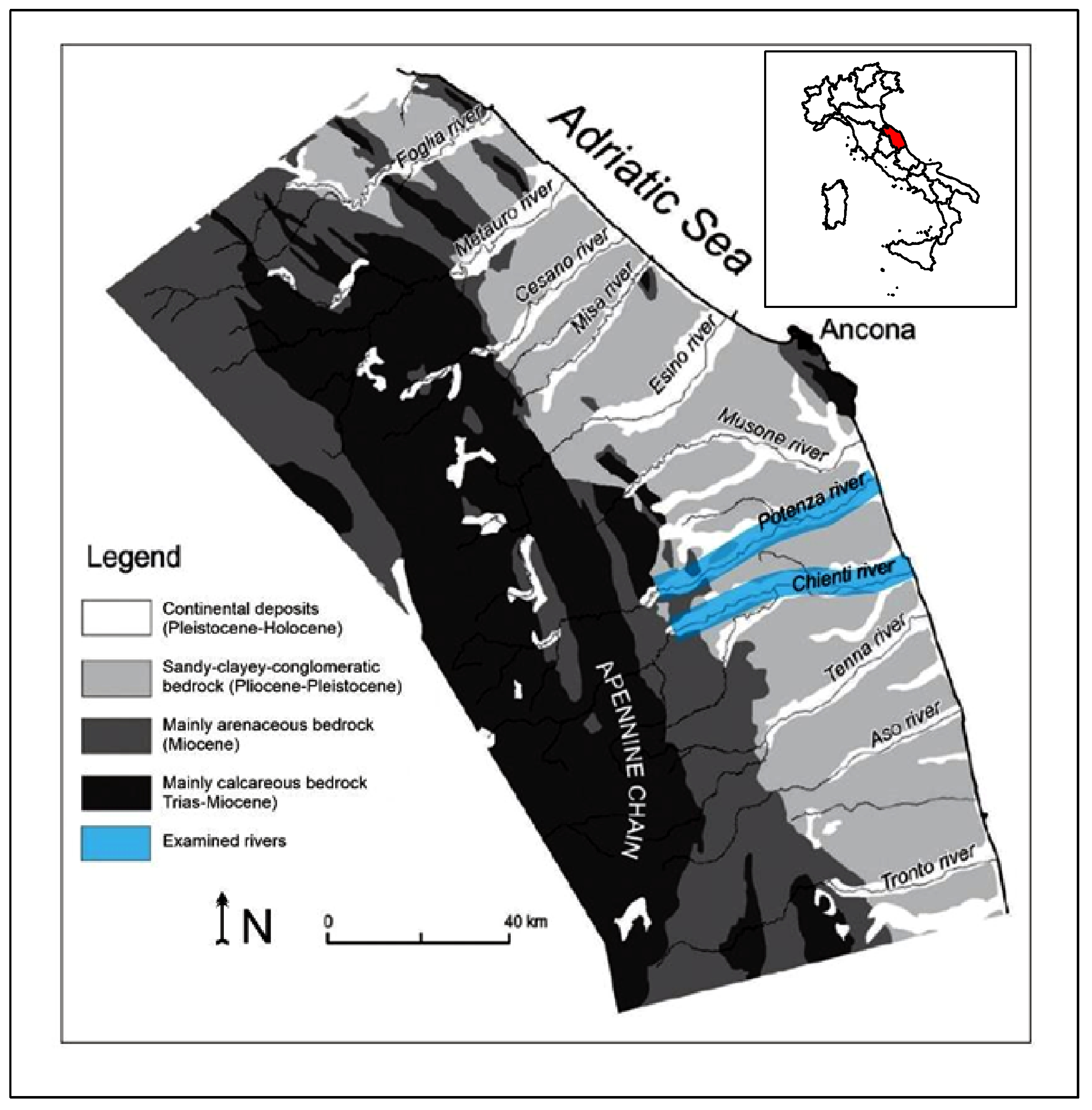
2.1. Study Area

This study considered the geomorphological processes and the anthropic impact of the river environment in the area surrounding sewage treatment plants, both civil and industrial, and also assessed the sustainability of the geological environment. In particular, the situations of 44 plants located in the basins of the Chienti and Potenza Rivers, two watercourses in the Marche region that drain their waters into the Adriatic Sea, were analyzed (Figure 1). The basins of these rivers are conditioned by the geological setting and the regional topographic gradient [7,8,42]. In particular, the Chienti River has a basin area of 1294 km2 and a length of 91 km, while the Potenza River has a basin area of 773 km2 and a length of 88 km.
The territory can be divided into three distinct sectors from west to east. In the mountainous belt, there is the presence of predominantly Mesozoic-tertiary limestone lithotypes structured in anticlines and synclines, complicated by Quaternary overthrusts and extensional faults, linked to the intense tectonic uplift that produced the strong deepening of the hydrographic network. The alternation of Quaternary climatic phases (glacial and interglacial) and Quaternary tectonic uplift have produced different orders of alluvial terraces throughout the area, which can be recognized in the piedmont, upland and Periadriatic mountain belts.
In the alluvial plains of the Chienti and Potenza Rivers (as in the remaining plains of the Marche region, Figure 1), different orders of terracing of the alluvial deposits can be recognized, which have taken place from the early Middle Pleistocene to the most recent, the Holocene terrace [11,43]. The oldest terrace is situated at a variable height relative to the present-day thalwegs of approximately 150–200 m. The Holocene terrace, as will be better described in the following chapter, was produced by the contributions of the heavily anthropized slopes from the Roman epoch onwards; it is situated at varying heights up to a maximum of about 10 m.
In terms of climate, the Marche region is a rather complex area that goes from a Mediterranean climate in the southern coastal area, to a warm temperate climate in the hilly area, to an altitude climate in the Umbro-Marchigiano Apennines [44]. The Marche region climate is characterized by hot, dry summers and cold, rainy winters, which can have quite substantial variations linked to the atmospheric dynamics prevailing in the North Atlantic area [45]. Precipitation can take on a snowy character in the mountains with annual amounts ranging from more than 2000 mm in the major peaks to 600 mm in some coastal areas [44,45,46,47]. Related to rainfall, particularly to extreme events, but also to the area’s significant seismicity, frequent and significant landslide phenomena occur in the investigated basins [48,49,50,51]. The resulting accumulations undoubtedly interact also with river dynamics, providing important contributions to the solid load of watercourses, both major and minor ones.
In this area, numerous man-made works exist to the present day, including the sewage treatment plants under study. These are mostly located along the main rivers, where there are towns of a certain size. A part of the plants is located along the minor hydrographic network, on the hilly areas where there are settlements of medieval origin. In the latter, the antiquity of the water and sewage network and the ancient cisterns have, over the centuries, favored water erosion phenomena and landslides along the slopes, to which problems with the purification plants have been added.

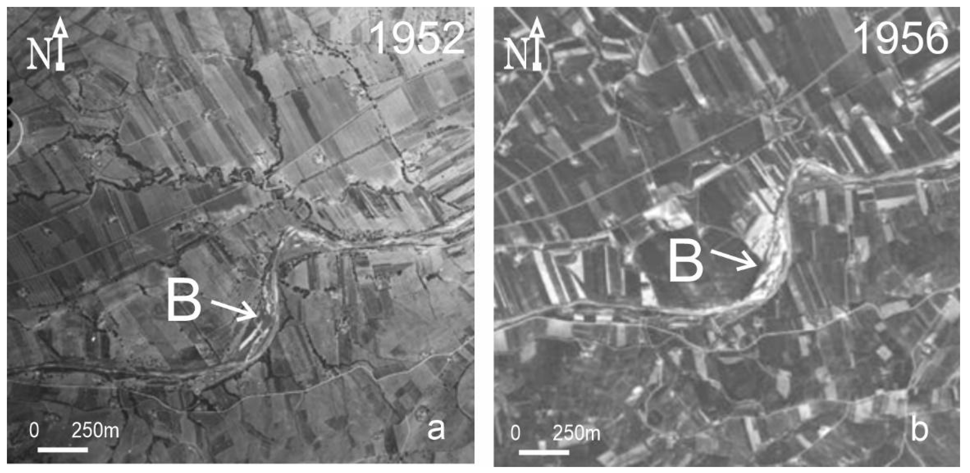
2.2. Erosion and Sedimentation Processes in the 20th Century

The recent Holocene floodplains of the middle and lower stretches of the basins considered in this study are extensive and continuous. The presence within the alluvial sediments of artefacts from the Roman and even earlier periods highlights that the deposits of these floodplains were sedimented because of degradation and erosion processes caused by the anthropization of the slopes. Massive deforestation for agro-pastoral purposes and timber supply continued from Roman times and only stopped with the unification of Italy in 1861 [52]. In central Italy, a practice called ‘alberata’ (Figure 2) was widespread, alternating cultivated fields and trees [53,54], but in the 1960s and 1970s there was extensive deforestation of these areas.
These processes have generated stable slopes, which have caused a drastic decrease in sediments in the main watercourses and thus an increase in their erosive power, together with the proliferation of artificial embankments. Nevertheless, until the late 1950s, phenomena of deepening linear erosion in this area were sporadic. While in the following decades, the substantial stability of riverbeds was compromised by intensive mining of inert materials [55,56,57]. The excavation in the riverbed, carried out almost exclusively in the middle and lower stretches of the rivers, where there were considerable volumes of gravel, caused strong deepening of the riverbed, which, after passing through the alluvium, became embedded for many stretches in the predominantly clayey bedrock of the hilly areas. Over time, the deep incisions caused considerable damage and destruction to the regulation works built in previous periods (artificial embankments, weirs, etc.) and other civil engineering works located along the watercourses or in the sub-river areas (bridges, channels, roads, etc.; Figure 3).
Regressive erosion has induced other geomorphological changes, such as landslides, shoreline changes and even variations in the water table [11,55,57,58]. The fine sediments present in the rivers due to the exposed conditions do not allow a balanced situation in the littorals. At the beginning of the 1990s, numerous sewage treatment plants were built along the main rivers and in the secondary hydrographic network because of a growing sensitivity to environmental protection, given the considerable economic and demographic development of some areas. In many cases, however, these plants were built in areas already affected by considerable erosional processes that were significantly amplified within a few years. The plants in question essentially treat wastewater from urban areas and their action on the hydrographic network was manifested by a significant increase in flow rates at discharge points and changes in the water chemistry downstream of the plants.

2.3. Workflow

The materials and methods are settled following the next work procedure according to which we developed our study. The first support was provided by the geomorphological field survey. Surveys and analyses were conducted with the aim of detecting in different areas both the active natural processes and the relations of these with anthropogenic works. In addition, numerous observations and measures have been carried out over the years to verify the extent of deepening directly on site, evaluating environmental changes and relating them to the climate trend, also analyzed. All the collected data were then entered into GIS software ArcGis 10.8 to quantify and compare the observed processes.
In this research, we also considered all the available maps and aerial photos for the area of interest from 1895, to the present. In more detail, the following mapping and images were analyzed: historical map published in 1895 by the IGM—Military Geographical Institute of Italy; aerial photos taken in 1952 and 1956 by IGM; aerial photos taken in 1985, 1988, 1997, 2004, and 2007 made available by the Marche Region archive; and images from 2013 and 2024 taken from the Google Earth archive.
Furthermore, chemical analyses were performed on water samples taken before and after the purification plants to assess the possible presence and effects of surfactants, which tend to increase the amounts of dissolved clay minerals. In order to calculate the consistency limits and thus the plasticity index, geotechnical analyses were conducted taking samples of the clayey bedrock both upstream and downstream of the sewage treatment plants. On these samples, X-ray diffractometric analyses were also performed to know and evaluate the presence of the different clay minerals.
We considered this methodologically very important because the chemical characteristics of the water have a great influence on the erodibility of the bedrock, even more so if clayey. The various compounds are found in ionic form, in a wide range of concentrations depending on their abundance in nature, their solubility and the chemical and physical processes they undergo. The content and percentage of the main ions depend, of course, on the chemical composition of the rocks and soils in the drainage area. The substances most frequently found, mainly resulting from human activities, and thus as a trace of pollution, are as follows: acids and alkalis, chlorine, ammonia, hydrogen sulfide, sulfates especially from paper mills, sulfites, cyanides, nitrites, nitrates, phosphates, iron and manganese salts, various hydrocarbon residues, vegetable oils, organic compounds and heavy metals, up to even radioisotopes.

3. Results

3.1. Identification of Study Cases

In the considered two catchment areas, many purification plants have been built, both in the main rivers and in their tributaries (Figure 4). During the first surveys it had become evident that, at the discharge points of the purified water injected into the hydrographic network, erosional phenomena were greatly amplified compared to adjacent situations without such inflows. In at least 22 cases, we observed situations of vertical deepening of the hydrographic network, manifested mainly through bank erosion in the main rivers and undermining at the foot of the slopes, in the minor network, with consequent landslide phenomena, mostly of flow type.
The different instability scenarios detected are uniformly located along the entire hydrographic network, from the innermost areas to the mouth. This confirms that the degradation is unequivocally linked to the presence of the purification plants rather than to the natural dynamics of the watercourse, which instead varies from area to area according to the equilibrium profile.

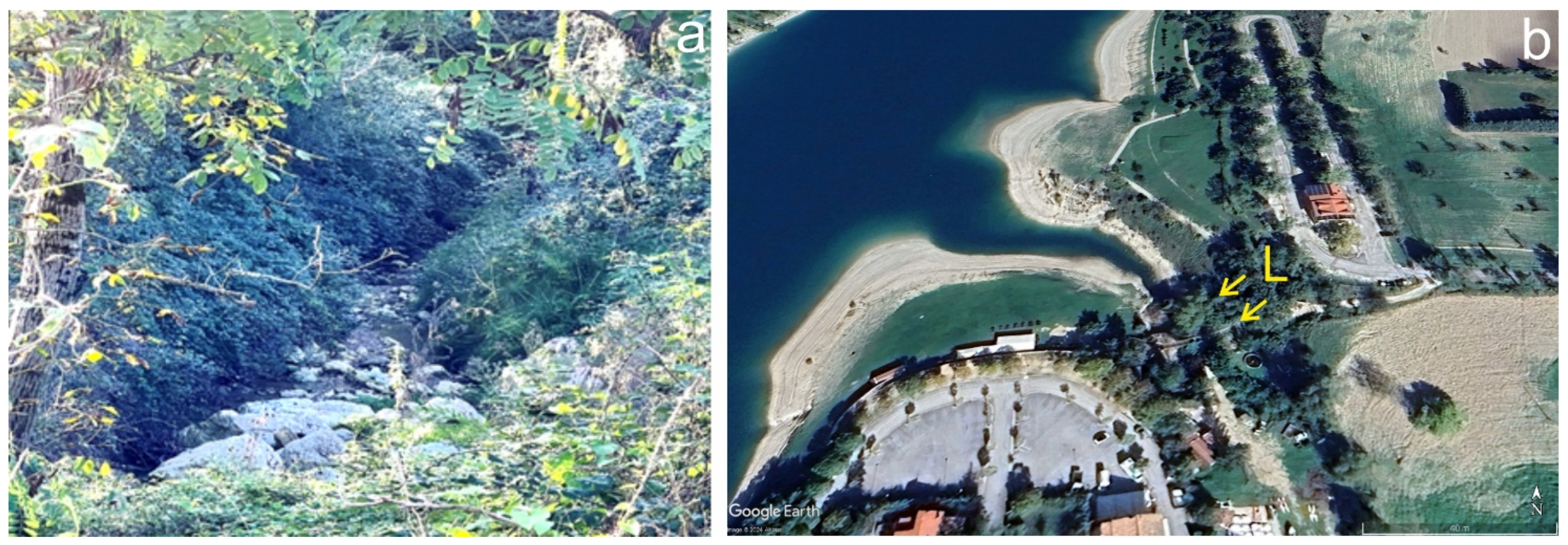
3.1.1. Scenarios of the Lower Part of the Basins

In the terminal stretches of the watercourses investigated, we have similar situations in proximity to the Porto Recanati (Potenza River) and Civitanova Marche (Chienti River) wastewater treatment plants. In these stretches, erosive activities occur at the level of the purifier discharge channels, which trigger instability phenomena along the adjacent banks and in the embankments. The result of these processes for this area is the increase in the river’s overflow area (Figure 5).

3.1.2. Scenarios of the Middle Part of the Basins

Similar scenarios are also observed in the intermediate stretches of the hydrographic network, as in the case of Corridonia-Sarrocciano (Chienti River), where the plant is in an overflow area. Here, the watercourse with the major flow coming from the sewage treatment plant channel constantly erodes the alluvial deposits (Figure 6) in which the riverbanks are modeled; during exceptional floods, these give way and extensive flooding phenomena occur, with damage also to the plant buildings.
In other situations, again along the middle stretches of the network, the vertical incision of the river has reached the bedrock, which, in these areas, is of a clayey nature, near the Passo di Treia water purification plant (Potenza River; Figure 7a). Here, erosive phenomena are concentrated along the left bank where the plant is located and have exposed discrete stretches of the pelitic bedrock formation. The erosional dynamics are triggered by a weir located just upstream, which has been undermined (Figure 7b). We have found that this type of imbalance in river dynamics also occurs near the San Severino Marche (Potenza River) and Macerata-VillaPotenza (Potenza River) purification plants.

3.1.3. Scenarios of the Higher Part of the Basins

Situations of vertical deepening, with bank erosion and triggering of landslide phenomena are also present in the more inland areas, such as near the depurator downstream of the town of Camerino (Potenza River). Here, the strong incision destabilizes banks of considerable height, cut on alluvial deposits, but on which slopes with quiescent landslide accumulations are sometimes found. The river incision of these deposits has increased their instability, even leading to the collapse of part of the road network above them (Figure 8a). A similar situation, again in the innermost areas of the basins, is that of Fiastra-San Lorenzo (Fiastrone-Chienti River). Here, the strong incision at the point where the water from the depurator enters triggers erosion and landslides in an area of high environmental and tourist value (Figure 8b). The dangerousness of the phenomena could be lowered by a different location of the drainage channel.

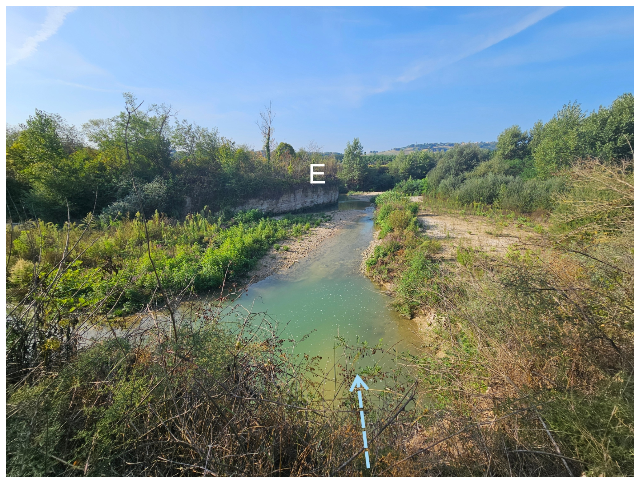
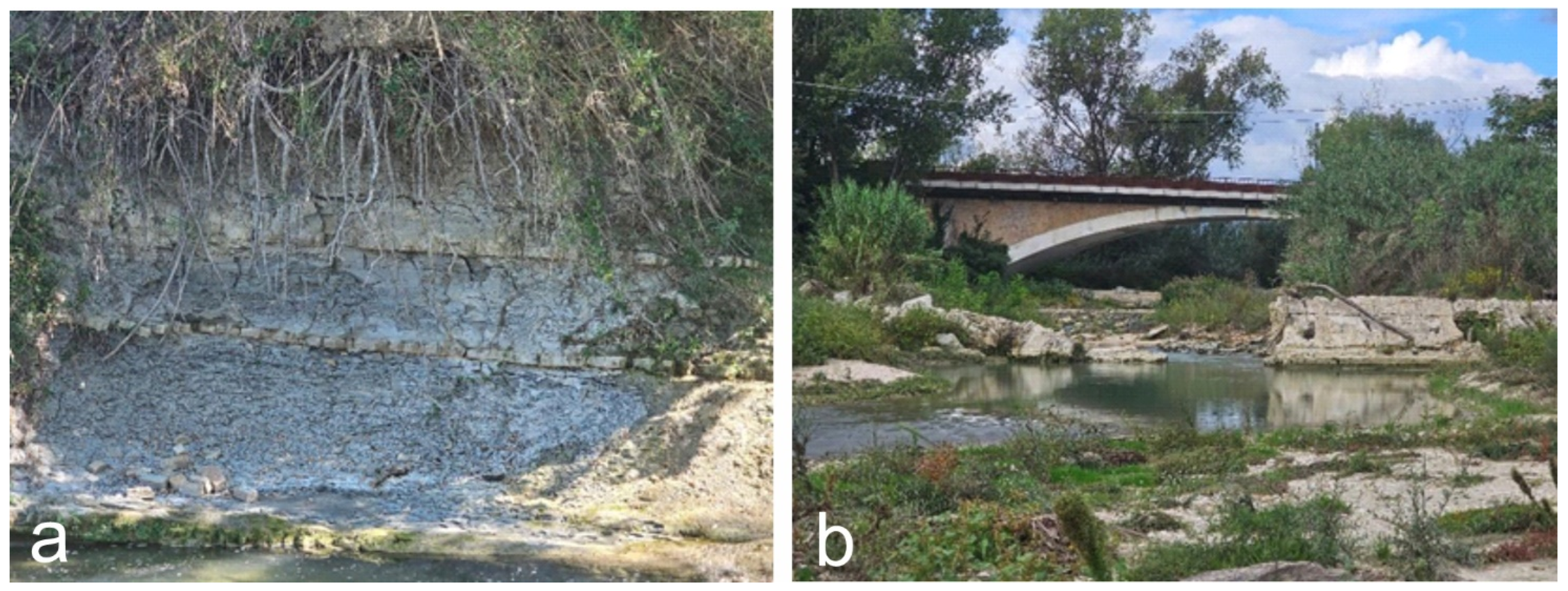
3.2. The Study Case of Tolentino

A particular case that we will illustrate in detail is the area surrounding the Tolentino wastewater treatment plant, located downstream from the city in the industrial and commercial area (Figure 4 and Figure 9). The City of Tolentino, like much of the Province of Macerata, underwent considerable economic and demographic development at the beginning of the 1980s, reaching a population of approximately 20,000 inhabitants, and it was then that the need was felt throughout the territory to plan several wastewater treatment plants (Figure 4).
The Tolentino wastewater treatment plant (depurator) consists of two lines, the first of which came into operation in 1986 and the second in 1994. The choice of location for the depurator in Tolentino, as unfortunately in many other localities, turned out to be wrong because the Chienti River, was already heavily eroded in that stretch and also well embedded in the Pliocene clays (Figure 1). Oral transmissions collected during our previous studies [11] tell us that toward the end of the 1940s, when the Pianarucci hydroelectric power station was built, the Chienti River was flowing in gravelly alluvium in that area, and the bedrock, which may have been close, had not, however, outcropped. An old topographic map at a scale of 1:50,000 dated 1895 (with surveys updated to 1902) shows the Chienti River with a multi-channel bed (anastomosed type) typical of riverbeds with abundant detrital material, mostly gravel (Figure 10).

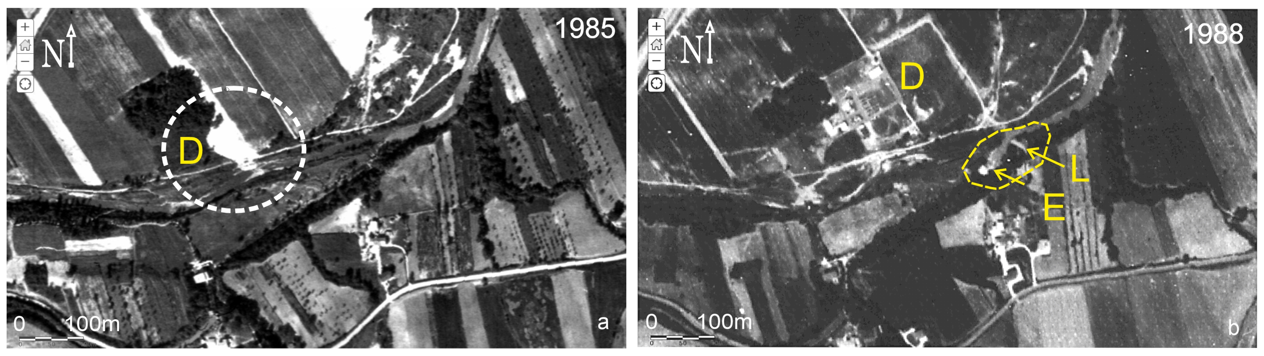
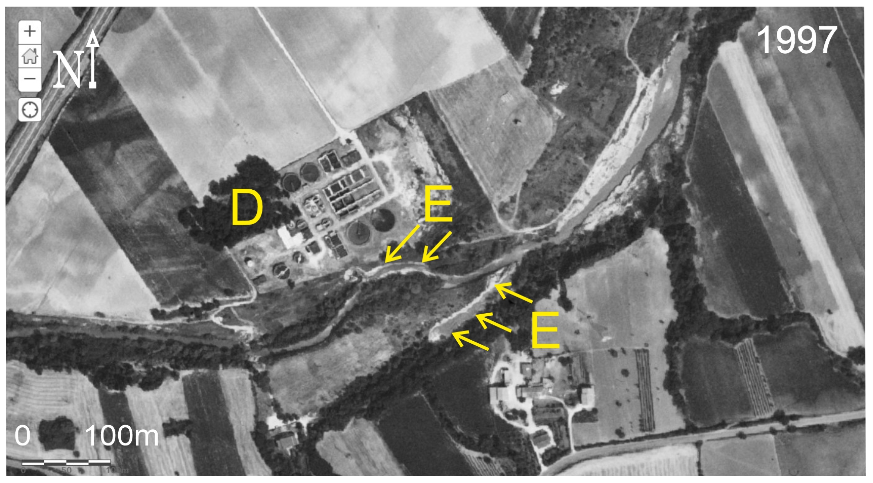
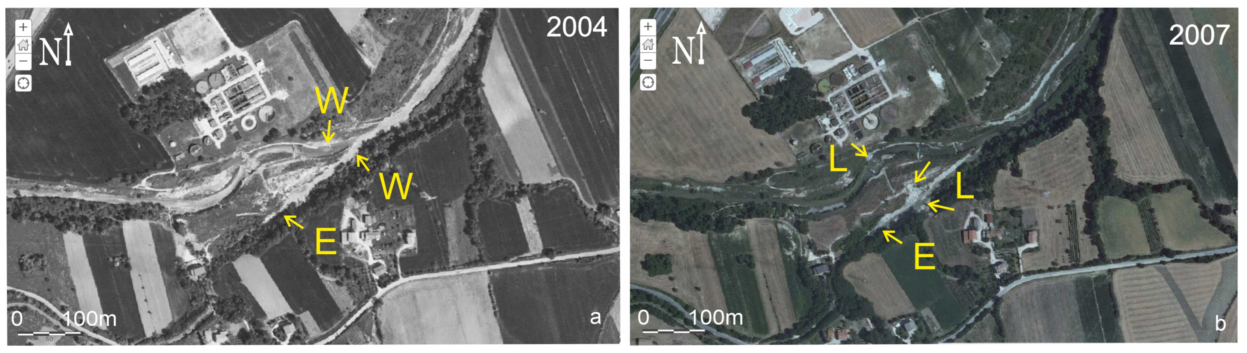
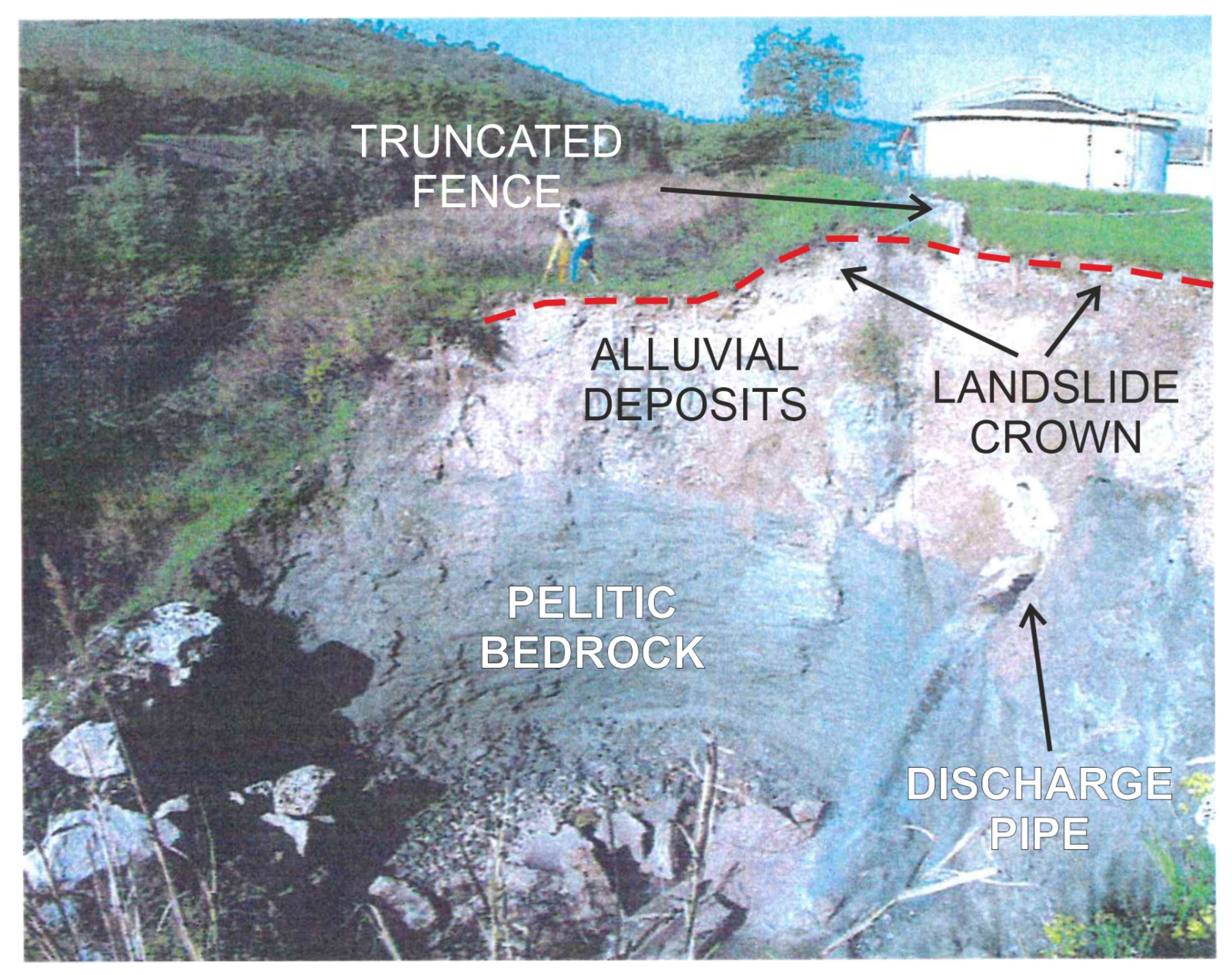
3.2.1. Results of Field Surveys and Analysis on Aerial Photos

The 1952 and 1956 aerial photographs, which can be consulted by the Italian Military Geographical Institute (IGM), show the area at distinct evolutionary stages (Figure 11a,b). The photo from 1952, about 10 years after the Pianarucci hydroelectric power plant came into operation, shows a riverbed still characterized by several channels and well laced with abundant gravelly debris (light shades). The diversion channel of the hydroelectric power plant is well vegetated up to the confluence with the Chienti River, testifying to a situation of probable hydrodynamic equilibrium. In the aerial photo taken in 1956, downstream of the confluence of the hydroelectric power plant channel with the Chienti River, a heavy accumulation of detrital materials (river bar with whitish tones, Figure 11b) can be seen in the curve of the river, proving that the erosional phenomena on the right bank and those upstream were such as exerting a considerable solid transport.
The sedimentation of alluvial materials downstream of the confluence can be attributed to the increased flow of the Chienti River in relation to the discharge of the hydroelectric power plant and partly to the normal evolution along the main river. Most probably the evolution of erosional processes at that time led the riverbed to further incise the clays that we observe today for long river stretches. We can therefore reasonably deduce that from the end of the 1950s until the mid-1980s, when our studies began systematically, the vertical incision in the clays made by the Chienti River reached a height of approximately 5–8 m, compatible with the average depths in the riverbed in the various rivers in the Marche region. The commissioning of the first line of the depurator, as we have mentioned, dates back to 1986. As can be seen from the photo in Figure 12a, in 1985, the area of the confluence between the diversion canal and the Chienti River was well vegetated and without evident erosional phenomena. On the contrary, in the frame relating to 1988 (Figure 12b), two years after the depurator had become operative, an important regressive erosion phenomenon can be seen in the power station canal, with the creation of a conspicuous widening of the canal and a landslide on the right bank. The regressive phenomenon was particularly violent as a concrete bridle that was placed in the canal near the confluence with the Chienti River was destroyed. Just upstream of this weir, a footbridge placed on the canal was also destroyed and overall, as can be estimated from the metric scale in Figure 12b, the phenomenon regressed by approximately 60 m. From what has been described, we can rightly assume that after two years of the first purification line coming into operation the erosional processes were strongly accelerated.
The regressive erosion phenomenon in the canal continued to progress further, reaching a total of approximately 120 m in 1994. In addition to the phenomenon of regressive erosion in the channel downstream of the confluence, there has been an intense lateral erosion in the banks of the Chienti River. This period coincides with the opening of the second depurator line. The erosional phenomena in the channel and along the main watercourse continued in the following years (Figure 13), accelerating around the year 2000, so much so that reclamation works were required through the construction of weirs along the Chienti River.
The 2004 aerial image (Figure 14a) shows a substantial regression of erosion in the channel by a further 60 m. The channel undergoes a strong widening that is also observed in the Fiume Chienti downstream of the confluence. Here, both on the left and right bank, the vegetation appears to be repopulating, most likely due to the deepening of the riverbed, which has created banks confining overflow phenomena. In 2007 (Figure 12b), the regressive phenomenon advanced further and some banks of the canal were affected by evident landslide phenomena. These phenomena are also observed on the right and left banks of the Chienti River, near the outlet of the depurator’s collector and the first weir located upstream.
The particularly unstable situation was treated in 2013 with the reclamation works in the area, which included the closure (tombing) of the hydroelectric power plant channel and the protection works (weirs, walls, gabions, etc.) of the banks of the Chienti River near the depurator’s discharge manifold (Figure 15a). About 10 years later, the weirs along the Chienti River are already damaged and erosional phenomena on the left bank are causing obvious collapses in the embankment (Figure 15b).
Regarding the erosion processes, a regional trend can be traced for the period of the last 60 years. To this purpose, the climatic trend is also recalled, dividing it into two intervals 1961–1990 and 1991–2020. In the study area, a decrease, albeit slight, in precipitation is observed between the periods 1961–1990 and 1991–2020. Specifically, over a larger area, meaning the Marche region including the study site, it shows an average change of about 13 mm between the two standard periods, 943 mm in 1961–1990 and 930 mm in 1991–2020 [59].
Concerning deepening rates, in general, it can be stated that an average deepening of about 166 mm/year (with peaks of 400 mm/year) was recorded in the 30-year period 1960–1990. In the 1990–2020 period, on the other hand, there is a slightly lower but still significant rate of 150 mm/year.

3.2.2. Results of Chemical, Geotechnical and XRD Analyses

Research on the environmental problems in the considered 44 depurators, as already mentioned, has focused in this first phase on the geomorphological processes of all the plants and in the analysis of the chemical parameters of the main depurators relating to the area’s major population centers. The chemical analyses we conducted (with the support of the Department of Experimental Medicine and Public Health of the University of Camerino) involved water sampling upstream, in the discharge area and downstream of the depurators (Figure 16). These are the plants of San Severino (loc. Pieve), Treia (loc. Passo di Treia), Macerata (loc. Villa Potenza), and Porto Recanati (loc. S. Maria in Potenza) for the Potenza River and Tolentino (loc. Rotondo), Corridonia (loc. Sarrocciano), and Civitanova Marche (Via Fontanelle) for the Chienti River. For the various parameters measured, the averages of the values measured in the recent sampling campaigns carried out in the summer and autumn periods were reported.
A preliminary analysis of the most significant data in the table shows that the values of Surfactants, Nitrates, Nitrites, Ammonia, and Chlorides, as well as Conductivity, Fixed residue, and Hardness, increase in the area downstream of the purifiers, compared to the data measured upstream, a trend also present in the Tolentino depurator. At this site, in order to verify the influence of the chemical substances present in the wastewater, preliminary sampling was carried out in the clays upstream and downstream of the plant.
Regarding geotechnical characteristics, the calculation of the consistency limits shows an increase in the liquid limit and consequently in the plasticity index between upstream and downstream. This increase affects the alteration mechanisms, increasing them and favoring greater erosion of the clay bedrock.
X-ray diffractometric analyses were performed on the same samples, which we summarize briefly here, while further investigations are underway. Analyses testify to appreciable changes in ionic bonds downstream of the depurator, probably caused by the chemicals present in the wastewater. These changes agree with those found in the plasticity index values. Finally, the higher content of smectitic or interstratified I-Mo-type minerals found in downstream samples compared to upstream samples, to the detriment of illitic and chloritic–kaolinitic clay minerals, establishes a less stable environment from the point of view of ion exchange.

4. Discussion

Research on rivers in the Marche region conducted by the Camerino University geomorphologists has a long history [11,12,13,24,40,41,42,43] and led to the definition of the following evolutionary framework of the relationship between slope and valley/fluvial dynamics. At the beginning of the 20th century, agricultural practices spread rapidly along the slopes and the hydraulic-forestry systems, terracing, hedges, and, above all, the planting of many trees, had the important function of soil conservation. The decrease in solid materials in the rivers and the narrowing of riverbeds with artificial embankments gave the river current greater speed and erosional power. At the beginning of the 1950s, the rivers began a slow and gradual deepening. In fact, up to that time, previous studies show a general balance between river and coastal dynamics, with the shoreline remaining essentially stable for solid inputs reaching the sea [11,12]. From the mid-1950s onward, with the needs of post-war reconstruction, huge gravel withdrawals began in the riverbeds. These withdrawals intensified at the height of economic development and anthropization of the floodplains and coastal areas, in the interval 1960–1975 [58]. The same process of mining in riverbeds has also occurred in many other rivers in Italy, with similar effects, namely, severe erosion, deepening of riverbeds, and interruption of the connection between aquifers in the alluvial deposits and the rivers [60]. The absence of larger sediment is also dictated by the numerous water detour and water catchment works, as well as dams along rivers, and this is found in many rivers in the Italian territory [61]. Suffice it to say that in the Chienti and Potenza Rivers, there are five artificial lakes (here, solid materials are trapped, and downstream rivers have greater erosional power) and more than 15 hydroelectric power stations, with their associated diversion channels. By-pass canals, as in our example in Tolentino, which with their excessive withdrawals, leave rivers for long stretches (even several kilometers) without the minimum vital runoff, greatly compromising the ecosystem and creating deep crevasses in the clay bedrock. These processes were and still are followed by damage and collapse of numerous man-made structures (bridges, artificial embankments, weirs, roads, etc.) and landslides along the riverbanks. These occurrences are also found in other Italian rivers, such that the observations appear to agree with the scientific literature on the subject [62].
The disequilibrium scenarios above reconstructed were further compromised by the construction of civil and industrial wastewater treatment plants in the 1980s and 1990s. The impact of these plants on river dynamics is considerable, not only because there are increases in flow rates at the discharge channels, but also because of the chemical content of the water re-introduced into the rivers. It is quite common to detect regressive erosion in the case of channels that go into the river having significant flow rates [63,64]. More rare is to find a study that in addition to flow-related erosion also takes into account the effect of surfactants on the degradation of the substrate that composes the riverbed [65].
By synthesizing the data presented in the particular case of the Tolentino depurator, which came into operation in 1986, it can be seen with certainty that after two years, in 1988, the acceleration of erosion was devastating, creating vertical deepening in the Chienti River and regressive erosion in the channel of the hydroelectric plant (Figure 12). The erosion of the canal caused the collapse of a weir and a concrete footbridge, located a little further upstream at the confluence with the Chienti River (Figure 14). The total regressive erosion at that time was about 180 m. The increase in the Chienti River’s flow rate, of just a few liters per second, induced by the depurator’s discharge and the water flowing into the Chienti from the hydroelectric power station’s canal, water that until then had not created such drastic erosion, do not, in our opinion, justify the occurrence of such a devastating phenomenon. It is therefore plausible to call into question the aggressiveness of water laden with chemical elements capable of modifying and/or breaking down the crystalline structure of clay minerals and creating easy erosion of the bedrock present, as demonstrated by the mineralogical analyses above illustrated.
The erosional phenomena, continued throughout the 1990s and most probably the malfunctioning of the purification system in the years 2000–2001 with the leakage of polluted sludge, caused a new acceleration of the erosional processes in the Chienti River and in the adjacent channel, where landslide phenomena also occurred (Figure 17). In order to limit the deepening of the riverbed, three large weirs were built in the Chienti River (Figure 14a), weirs that will soon be undermined by erosional processes. Regressive erosion in the channel progressed almost to the power station (Figure 14b), and, in 2013, a decision was made to restore it by tombing the canal (Figure 15a). Today, about 10 years later, the weirs on the Chienti River show evident damage and, as proof that erosion continues, collapse phenomena are taking place on the left bank, creating strong retreats of the river escarpment, affecting the gravelly alluvium and clays below (Figure 15b).
Extending the reasoning to the regional level, the magnitudes of erosional processes described in the results can be interpreted as follows. It can be stated that in the 1960–1990 period, the detected high rate is due overall to the many quarries in the riverbed, which triggered strong erosional phenomena in addition to the natural river dynamics. In the 1990–2020 period, there is a slightly lower but still significant rate, which is no longer due to the quarries (dismissed), but probably to the inputs from the wastewater treatment plants that strongly altered the river dynamics as shown. The latter aspect is amplified by the climatic trend, which sees a decrease in rainfall in the latter period compared to the former.
All the above fits well with the results of the chemical and geotechnical analyses presented above. In fact, downstream of treatment plants, the higher content of smectitic or interstratified I-Mo-type minerals and a decrease in illitic and chloritic–kaolinitic clay minerals, results in a less stable environment in terms of ion exchange, which is also evidenced by the increasing of plasticity index limits. This causes the ionic bonds of the bedrock clays to break more easily, resulting in greater erosional power of the river waters.
Consulting a broader scientific context, we saw that this situation is not unique in the world, yet it is little studied and rather unsuitable from the point of view of environmental protection. In the literature, very often the erosivity of hydroelectric channels is analyzed [66,67], while it is much rarer to find works highlighting chemical erosion of the substrate by surfactants. For this reason, we have attempted an early interpretation that is as objective as possible regarding the phenomena detected in our study cases.
The limit of this research was to have only a few study cases (fortunately) where erosion had reached the clay bedrock, and, therefore, only to have a few points with chemical and geotechnical data analysis. However, studies can also be carried out on the sizing of the plants themselves, purification techniques and discharge systems, to better protect the fluvial environment.

5. Conclusions

As a final analysis of the work undertaken, the main points are summarized below to highlight the most important elements to be drawn.
-
Erosion of rivers due to man-made works is a problem that has become increasingly important over the last thirty years.
-
Erosion has had increases attributed to physical reasons (change in river flow) and chemical reasons (change in water chemistry).
-
Water purification plants can play a role in the degradation of substrates, but also mechanical erosion of channels used to return water after it has fed hydroelectric plants.
-
In the Chienti and Potenza Rivers, we verified these processes assessing the changes in the dynamics of the rivers and quantifying the generated erosion.
-
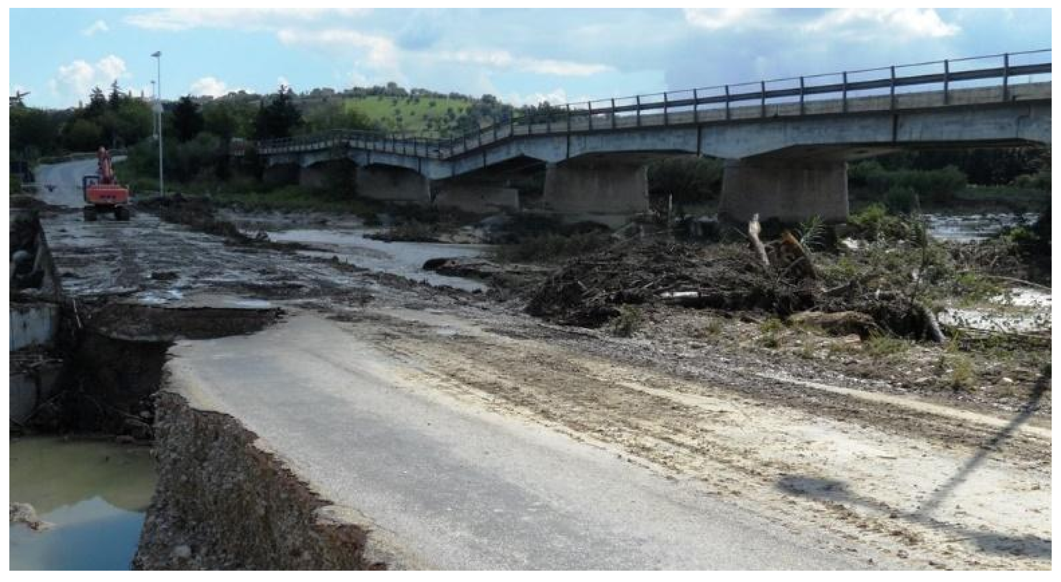
Regressive erosion was observed at these plants by means of geomorphological surveys, analyses from aerial photographs, and historical maps.
-
By conducting chemical analyses on water samples and mineralogical/geotechnical analyses on clay bedrock, an attempt was made to understand how erosion is influenced by surfactants in wastewater.
-
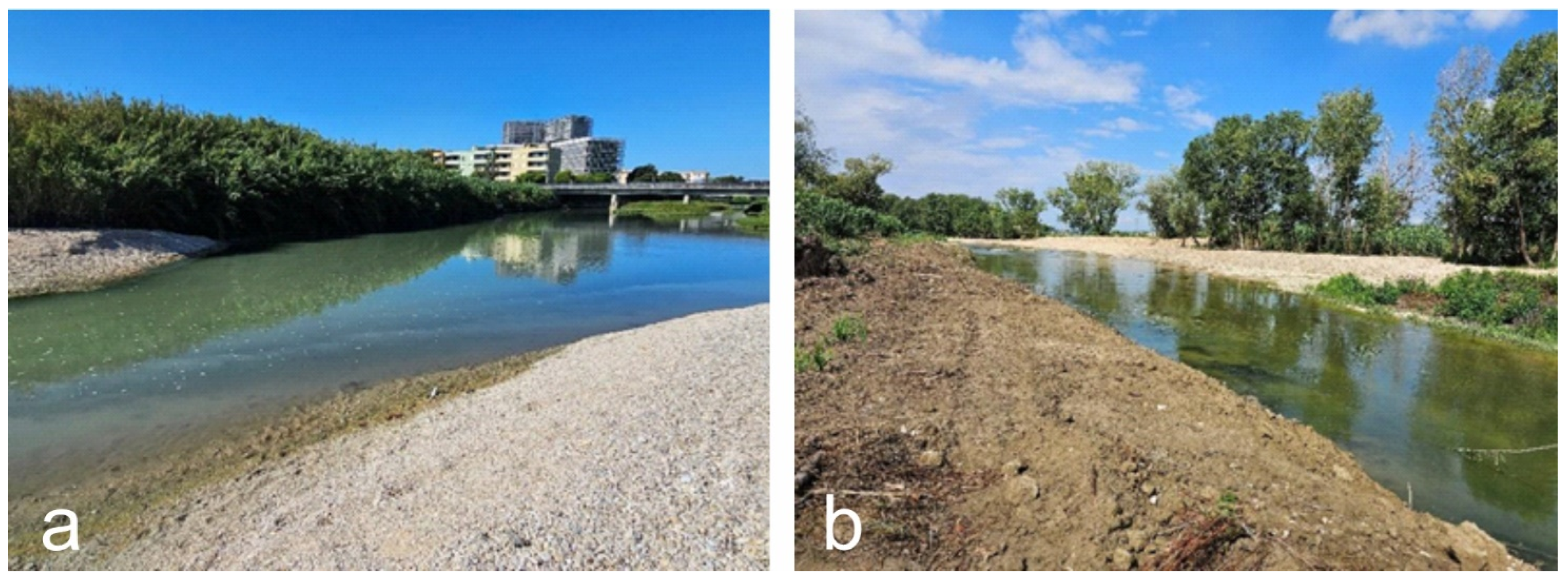
The surveys made it possible to assess the deepening of the riverbed, estimating the erosion rate over time quite accurately, which was found to be as follows.
In the 30-year period 1960–1990, there was an average of about 166 mm/year (with peaks of 400 mm/year), a high rate due overall to the numerous excavations in the riverbed that triggered strong erosional phenomena in addition to the natural river dynamics.
In the 1990–2020 period, there is a slightly lower but still significant rate of 150 mm/year, no longer due to (disused) quarries, but probably due to inputs from sewage treatment plants that have greatly altered the river dynamics as shown. The effect of decreasing rainfall in recent decades is also considered.
These results highlight an issue that must be analyzed and properly curbed when designing a new wastewater purification plant or hydroelectric plant, limiting erosion as much as possible. Whereas for existing plants, this erosion measurement could make it possible to evaluate suitable countermeasures to diminish this problem, e.g., by dividing the channel flow into several channels and adopting wastewater purification systems that limit the emission of surfactants.

Author Contributions

Conceptualization, D.A. and G.P.; methodology, D.A. and G.P.; software, D.A. and G.P.; validation, D.A. and G.P.; formal analysis, D.A., G.P. and M.B.; investigation, D.A. and G.P.; resources, D.A. and G.P.; data curation, D.A., G.P. and F.B.; writing—original draft preparation, D.A., G.P. and P.F.; writing—review and editing, D.A., G.P. and M.G.; visualization, D.A., G.P. and F.L.; supervision, D.A., G.P., M.M. and M.G.; project administration, D.A., G.P. and M.G. All authors have read and agreed to the published version of the manuscript.

Funding

This research received no external funding.

Institutional Review Board Statement

Not applicable.

Informed Consent Statement

Not applicable.

Data Availability Statement

The original contributions presented in the study are included in the article; further inquiries can be directed to the corresponding author.

Conflicts of Interest

The authors declare no conflicts of interest.

References

  1. Preece, R.C.; Bridgland, D.R. Holywell Coombe, Folkestone: A 13,000 year history of an English Chalkland Valley. Quat. Sci. Rev. 1999, 18, 1075–1125. [Google Scholar] [CrossRef]
  2. Brocard, G.Y.; van der Beek, P.A.; Bourlès, D.L.; Siame, L.L.; Mugnier, J.L. Long-term fluvial incision rates and postglacial river relaxation time in the French Western Alps from 10Be dating of alluvial terraces with assessment of inheritance, soil development and wind ablation effects. Earth Planet. Sci. Lett. 2003, 209, 197–214. [Google Scholar] [CrossRef]
  3. Schumm, S.A. River response to baselevel change: Implications for sequence stratigraphy. J. Geol. 1993, 101, 279–294. [Google Scholar] [CrossRef]
  4. Holbrook, J.; Scott, R.W.; Oboh-Ikuenobe, F.E. Base-level buffers and buttresses: A model for upstream versus downstream control on fluvial geometry and architecture within sequences. J. Sediment. Res. 2006, 76, 162–174. [Google Scholar] [CrossRef]
  5. Pszonka, J.; Wendorff, M.; Godlewski, P. Sensitivity of marginal basins in recording global icehouse and regional tectonic controls on sedimentation. Example of the Cergowa Basin, (Oligocene) Outer Carpathians. Sediment. Geol. 2023, 444, 106326. [Google Scholar] [CrossRef]
  6. Schumm, S.A.; Dumont, J.F.; Holbrook, J.M. Active Tectonics and Alluvial Rivers; Cambridge University Press: Cambridge, UK, 2000; p. 276. [Google Scholar]
  7. Dufaure, J.; Bossuyt, D.; Rasse, M. Déformations quaternaires et morphogénèse de l’Apennin Central Adriatique. Physio-Géo. 1988, 18, 9–46. [Google Scholar]
  8. Dramis, F. Il ruolo dei sollevamenti tettonici a largo raggio nella genesi del rilievo appenninico. Stud. Geol. Camerti 1992, 1, 9–15. [Google Scholar]
  9. Ciccacci, S.; D’Alessandro, L.; Dramis, F.; Fredi, P.; Pambianchi, G. Geomorphological and neotectonic evolution of the Umbria-Marche ridge, northern sector. Stud. Geol. Camerti 1985, 10, 7–15. [Google Scholar]
  10. Surian, N.; Rinaldi, M. Morphological response to river engineering and management in alluvial channels in Italy. Geomorphology 2003, 50, 307–326. [Google Scholar] [CrossRef]
  11. Mandarino, A.; Faccini, F.; Terrone, M.; Paliaga, G. Anthropogenic landforms and geo-hydrological hazards of the Bisagno Stream catchment (Liguria, Italy). J. Maps 2021, 17, 122–135. [Google Scholar] [CrossRef]
  12. Baessler, C.; Klotz, S. Effects of changes in agricultural land-use on landscape structure and arable weed vegetation over the last 50 years. Agric. Ecosyst. Environ. 2006, 115, 43–50. [Google Scholar] [CrossRef]
  13. Aringoli, D.; Buccolini, M.; Coco, L.; Dramis, F.; Farabollini, P.; Gentili, B.; Giacopetti, M.; Materazzi, M.; Pambianchi, G. The effects of in-stream gravel mining on river incision: An example from Central Adriatic Italy. Z. Geomorphol. 2015, 59, 95–107. [Google Scholar] [CrossRef]
  14. Collier, M.; Webb, R.H.; Schmidt, J.C. Dams and Rivers: A Primer on the Downstream Effects of Dams; US Department of the Interior: Washington, DC, USA, 1996.
  15. Petit, F.; Poinsart, D.; Bravard, J.P. Channel incision, gravel mining and bedload transport in the Rhône river upstream of Lyon France (“canal de Miribel”). Catena 1996, 26, 209–226. [Google Scholar] [CrossRef]
  16. Kondolf, G.M. Hungry water: Effects of dams and gravel mining on river channels. Environ. Manag. 1997, 21, 533–551. [Google Scholar] [CrossRef]
  17. García-Ruiz, J.M.; Valero-Garcés, B.L. Historical Geomorphic Processes and Human Activities in the Central Spanish Pyrenees. Mt. Res. Dev. 1998, 18, 309–320. [Google Scholar] [CrossRef]
  18. Hudson, P.F.; Kesel, R.H. Channel migration and meander-bend curvature in the lower Mississippi River prior to major human modification. Geology 2000, 28, 531–534. [Google Scholar] [CrossRef]
  19. Hudson, P.F.; Middelkoop, H.; Stouthamer, E. Flood management along the Lower Mississippi and Rhine Rivers (The Nethelands) and the continuum of geomorphic adjustment. Geomorphology 2008, 101, 209–236. [Google Scholar] [CrossRef]
  20. Leopold, L.B. River Channel Change with Time: An Example: Address as Retiring President of The Geological Society of America, Minneapolis, Minnesota, November 1972. GSA Bull. 1973, 84, 1845–1860. [Google Scholar] [CrossRef]
  21. Gregory, K.J.; Park, C. Adjustment of river channel capacity downstream from a reservoir. Water Resour. Res. 1974, 10, 870–873. [Google Scholar] [CrossRef]
  22. Farabollini, P.; Aringoli, D.; Gentili, B.; Materazzi, M.; Pambianchi, G. Processi di approfondimento dell’erosione in alveo ed effetti dell’inquinamento nei fiumi delle Marche centro-meridionali (Italia centrale). Alp. Mediterr. Quat. 2008, 21, 317–330. [Google Scholar]
  23. Borelli, P.; Hoelzmann, P.R.; Knitter, D.; Schutt, B. Late Quaternary soil erosion and landscape development in the Apennine region (central Italy). In Proceedings of the LAC 2012: 2nd International Landscape and Archaeology Conference, Berlin, Germany, 6–9 June 2012; Volume 312, pp. 96–108. [Google Scholar]
  24. Rinaldi, M.; Surian, N.; Comiti, F.; Bussettini, M. A method for the assessment and analysis of the hydromorphological condition of Italian streams: The morphological quality index (MQI). Geomorphology 2013, 180–181, 96–108. [Google Scholar] [CrossRef]
  25. Bravard, J.P.; Amoros, C.; Pautou, G.; Bornette, G.; Bournaud, M.; Creuze Des Chatelliers, M.; Gibert, J.; Peiry, G.L.; Perrin, O.; Tachet, H. River incision in south-east France morphological phenomena and ecological effects. Regul. Rivers Res. Manag. 1997, 13, 75–90. [Google Scholar] [CrossRef]
  26. Brown, A.V.; Lyttle, M.M.; Brown, K.B. Impacts of Gravel Mining on Gravel Bed Streams. Trans. Am. Fish. Soc. 1998, 127, 979–994. [Google Scholar] [CrossRef]
  27. Marchetti, M. Environmental changes in the central Po Plain (northern Italy) due to fluvial modifications and anthropogenic activities. Geomorphology 2002, 44, 361–373. [Google Scholar] [CrossRef]
  28. Simon, A.; Rinaldi, M. Disturbance, stream incision, and channel evolution: The roles of excess transport capacity and boundary materials in controlling channel response. Geomorphology 2006, 79, 361–383. [Google Scholar] [CrossRef]
  29. Mossa, J.; Marks, S.R. Pit Avulsions and Planform Change on a Mined River Floodplain: Tangipahoa River, Louisiana. Phys. Geogr. 2011, 32, 512–532. [Google Scholar] [CrossRef]
  30. Alighalehbabakhani, F.; Miller, C.J.; Selegean, J.P.; Barkach, J.; Sadatiyan Abkenar, S.M.; Dahl, T.; Baskaran, M. Estimates of sediment trapping rates for two reservoirs in the Lake Erie watershed: Past and present scenarios. J. Hydrol. 2017, 544, 147–155. [Google Scholar] [CrossRef]
  31. Mekonnen, M.; Keesstra, S.D.; Baartman, J.E.; Ritsema, C.J.; Melesse, A.M. Evaluating sediment storage dams: Structural off-site sediment trapping measures in northwest ethiopia. Cuad. Investig. Geográfica 2015, 41, 7–22. [Google Scholar] [CrossRef]
  32. Issa, I.E.; Al-ansari, N.; Knutsson, S.; Sherwany, G. Monitoring and Evaluating the Sedimentation Process in Mosul Dam Reservoir Using Trap Efficiency Approaches. Engineering 2015, 7, 190–202. [Google Scholar] [CrossRef]
  33. Kummu, M.; Lu, X.X.; Wang, J.J.; Varis, O. Geomorphology Basin-wide sediment trapping efficiency of emerging reservoirs along the Mekong. Geomorphology 2010, 119, 181–197. [Google Scholar] [CrossRef]
  34. Mulu, A.; Dwarakish, G.S. Different Approach for Using Trap Efficiency for Estimation of Reservoir Sedimentation. An Overview. Aquat. Procedia 2015, 4, 847–852. [Google Scholar] [CrossRef]
  35. Yang, X.; Lu, X.X. Geomorphology Estimate of cumulative sediment trapping by multiple reservoirs in large river basins: An example of the Yangtze River basin. Geomorphology 2014, 227, 49–59. [Google Scholar] [CrossRef]
  36. Conoscenti, C.; Martinello, C.; Alfonso-Torreño, A.; Gómez-Gutiérrez, Á. Predicting sediment deposition rate in check-dams using machine learning techniques and high-resolution DEMs. Environ. Earth Sci. 2021, 80, 380. [Google Scholar] [CrossRef]
  37. Arulanandan, K.; Sargunam, A.; Loganathan, P.; Krone, R. Application of Chemical and Electrical parameters to prediction of erodibility. In Soil Erosion: Causes and Mechanisms; Prevention and Control, Special Rep. 135; Highway Research Board: Washington, DC, USA, 1973; pp. 42–51. [Google Scholar]
  38. Osman, A.M.; Thorne, C.R. Riverbank Stability Analysis. I: Theory. J. Hydraul. Eng. 1988, 114, 134–150. [Google Scholar] [CrossRef]
  39. Esposito, L.; Diogene, G. Effetti dell’inquinamento sul comportamento meccanico dei terreni. Quad. dtai Geol. Appl. 2002, 9, 9–20. [Google Scholar]
  40. Lavé, J.; Avouac, J.P. Fluvial incision and tectonic uplift across the Himalayas of central Nepal. J. Geophys. Res. Solid Earth 2001, 106, 26561–26591. [Google Scholar] [CrossRef]
  41. Bufalini, M.; Aringoli, D.; Bendia, F.; Farabollini, P.; Gentilucci, M.; Lampa, F.; Martinello, C.; Materazzi, M.; Pambianchi, G. The Role of Wastewater in Controlling Fluvial Erosion Processes on Clayey Bedrock. Land 2023, 12, 227. [Google Scholar] [CrossRef]
  42. Dramis, F.; Gentili, B. La frequenza areale di drenaggio ed il suo impiego nella valutazione quantitativa dell’erosione lineare di superfici con caratteristiche omogenee. Mem. Soc. Geol. It. 1975, 14, 337–349. [Google Scholar]
  43. Nesci, O.; Savelli, D.; Troiani, F. Types and development of stream terraces in the Marche Apennines (central Italy): A review and remarks on recent appraisals. Géomorphologie 2012, 18, 215–238. [Google Scholar] [CrossRef]
  44. Gentilucci, M.; Rossi, A.; Pelagagge, N.; Aringoli, D.; Barbieri, M.; Pambianchi, G. GEV Analysis of Extreme Rainfall: Comparing Different Time Intervals to Analyse Model Response in Terms of Return Levels in the Study Area of Central Italy. Sustainability 2023, 15, 11656. [Google Scholar] [CrossRef]
  45. Gentilucci, M.; Domenicucci, S.; Barbieri, M.; Hamed, Y.; Hadji, R.; Missaoui, R.; Pambianchi, G. Spatial Effects of NAO on Temperature and Precipitation Anomalies in Italy. Water 2023, 15, 3727. [Google Scholar] [CrossRef]
  46. Gentilucci, M.; Catorci, A.; Panichella, T.; Moscatelli, S.; Hamed, Y.; Missaoui, R.; Pambianchi, G. Analysis of snow cover in the Sibillini Mountains in Central Italy. Climate 2023, 11, 72. [Google Scholar] [CrossRef]
  47. Li, B.; Chen, Y.; Chen, Z.; Li, W.; Zhang, B. Variations of temperature and precipitation of snowmelt period and its effect on runoff in the mountainous areas of Northwest China. J. Geogr. Sci. 2013, 23, 17–30. [Google Scholar] [CrossRef]
  48. Gu, D.M.; Huang, D.; Yang, W.D.; Zhu, J.L.; Fu, G.Y. Understanding the triggering mechanism and possible kinematic evolution of a reactivated landslide in the Three Gorges Reservoir. Landslides 2017, 14, 2073–2087. [Google Scholar] [CrossRef]
  49. Aringoli, D.; Farabollini, P.; Pambianchi, G.; Materazzi, M.; Bufalini, M.; Fuffa, E.; Gentilucci, M.; Scalella, G. Geomorphological hazard in active tectonics area: Study cases from Sibillini mountains thrust system (Central Apennines). Land 2021, 10, 510. [Google Scholar] [CrossRef]
  50. Aringoli, D. Hydrogeological and climatic risks: The emblematic case of an exceptional debris flow in central Apennines (Italy). In Advances in Science, Technology & Innovation; Chenchouni, H., Zhang, Z., Bisht, D.S., Gentilucci, M., Chen, M., Chaminé, H.I., Barbieri, M., Jat, M.K., Rodrigo-Comino, J., Eds.; Springer: Cham, Switzerland, 2024; pp. 283–290. [Google Scholar]
  51. Mangifesta, M.; Aringoli, D.; Pambianchi, G.; Giannini, L.M.; Scalella, G.; Sciarra, N. A Methodologic Approach to Study Large and Complex Landslides: An Application in Central Apennines. Geosciences 2024, 14, 272. [Google Scholar] [CrossRef]
  52. Di Pasquale, G.; Buonincontri, M.P.; Allevato, E.; Saracino, A. Human-derived landscape changes on the northern Etruria coast (western Italy) between Roman times and the late Middle Ages. Holocene 2014, 24, 1491–1502. [Google Scholar] [CrossRef]
  53. Sereni, E. Storia del Paesaggio Agrario Italiano; Laterza: Bari, Italy, 1979; 484p. [Google Scholar]
  54. Conosci L’Italia. Vol. 7 Il Paesaggio Ed. 1963 Touring Club Italiano A11—1 gennaio 1963. Available online: https://www.amazon.it/Conosci-LItalia-Paesaggio-Touring-Italiano/dp/B00W19L3WM (accessed on 10 October 2024).
  55. Albani, D. Indagine Preventiva Sulle Recenti Variazioni Della Linea di Spiaggia Delle Coste Italiane; Comit. Naz. Geogr. CNR: Roma, Italy, 1933; 93p. [Google Scholar]
  56. Conti, A.; Di Eusebio, F.; Dramis, F.; Gentili, B. Evoluzione geomorfologica recente e processi in atto nell’alveo del Tenna (Marche meridionali). Atti XXIII Congr. Geogr. It. Catania 1983, 2, 53–56. [Google Scholar]
  57. Coltorti, M.; Gentili, B.; Pambianchi, G. Evoluzione geomorfologica ed impatto antropico nei sistemi idrografici delle Marche: Riflessi sull’ambiente fisico. Mem. Della Soc. Geogr. Ital. 1995, 53, 271–292. [Google Scholar]
  58. Coltorti, M. Modificazioni morfologiche oloceniche nelle piane alluvionali marchigiane: Alcuni esempi nei fiumi Misa, Cesano e Musone. Geogr. Fis. Dinam. Quat. 1991, 14, 73–86. [Google Scholar]
  59. Liu, R.; Liu, S.C.; Cicerone, R.J.; Shiu, C.J.; Li, J.; Wang, J.; Zhang, Y. Trends of extreme precipitation in eastern China and their possible causes. Adv. Atmos. Sci. 2015, 32, 1027–1037. [Google Scholar] [CrossRef]
  60. Belletti, B.; Nardi, L.; Rinaldi, M. Diagnosing problems induced by past gravel mining and other disturbances in Southern European rivers: The Magra River, Italy. Aquat. Sci. 2016, 78, 107–119. [Google Scholar] [CrossRef]
  61. Anfuso, G.; Pranzini, E.; Vitale, G. An integrated approach to coastal erosion problems in northern Tuscany (Italy): Littoral morphological evolution and cell distribution. Geomorphology 2011, 129, 204–214. [Google Scholar] [CrossRef]
  62. Bazzoffi, P. Soil erosion tolerance and water runoff control: Minimum environmental standards. Reg. Environ. Change 2009, 9, 169–179. [Google Scholar] [CrossRef]
  63. Booth, D.B.; Henshaw, P.C. Rates of channel erosion in small urban streams. In Land Use and Watersheds: Human Influence on Hydrology and Geomorphology in Urban and Forest Areas; Wiley: Hoboken, NJ, USA, 2001; Volume 2, pp. 17–38. [Google Scholar]
  64. Seidl, M.A.; Dietrich, W.E.; Schmidt, K.H.; De Ploey, J. The problem of channel erosion into bedrock. Funct. Geomorphol. 1992, 23, 101–124. [Google Scholar]
  65. Herz-Thyhsen, R.J.; Kaszuba, J.P.; Dewey, J.C. Mineral dissolution and precipitation induced by hydraulic fracturing of a mudstone and a tight sandstone in the Powder River Basin, Wyoming, USA. Appl. Geochem. 2020, 119, 104636. [Google Scholar] [CrossRef]
  66. Kuriqi, A.; Pinheiro, A.N.; Sordo-Ward, A.; Bejarano, M.D.; Garrote, L. Ecological impacts of run-of-river hydropower plants—Current status and future prospects on the brink of energy transition. Renew. Sustain. Energy Rev. 2021, 142, 110833. [Google Scholar] [CrossRef]
  67. Darries, G.; Ayeleso, A.; Raji, A. Exploring hydropower options at A wastewater treatment plant-A case study. In Proceedings of the 2022 30th Southern African Universities Power Engineering Conference (SAUPEC), Durban, South Africa, 25–27 January 2022; pp. 1–6. [Google Scholar]
Figure 1. Geological features and main water courses of the Marche region with location of the examined rivers.
Sustainability 17 02711 g001
Figure 2. Historical photograph of the rural landscape surrounding the city of Camerino with the characteristic ‘alberata’ cultivations seen in the 1920s and 1930s [54]).
Sustainability 17 02711 g002
Figure 3. Damaged bridge and road along the mid-stream of the Chienti River due in recent times to strong incision and undercutting of the river during a flood.
Sustainability 17 02711 g003
Figure 4. A map of the wastewater treatment plants’ locations along the Potenza and Chienti Rivers with the major instability situations.
Sustainability 17 02711 g004
Figure 5. The weak embankments that are always to be restored to mitigate the hazard of flooding near the depurators of the Municipality of Porto Recanati (a) and Civitanova Marche (b).
Sustainability 17 02711 g005
Figure 6. Alluvial plain area in the middle course of the Chienti River near Corridonia in the stretch after the depurator discharge with the drainage channel in the foreground (arrow) and eroding banks in the background (E).
Sustainability 17 02711 g006
Figure 7. Downcutting in the clay bedrock (a) and example of the undermining of a weir near the Passo di Treia depurator (b).
Sustainability 17 02711 g007
Figure 8. (a) Area in the vicinity of the Camerino wastewater depurator where the blocks in the riverbed result from the collapse of the road above due to bank erosion. (b) Fiastra Lake with the confluence of a tributary where the depurator discharge is connected, triggering erosion and small landslides on the banks (L).
Sustainability 17 02711 g008
Figure 9. Topographical map edited by the Military Geographical Institute (IGM) of the Tolentino area, modified to obtain the location of the hydroelectrical power station and wastewater treatment plant along the Chienti River.
Sustainability 17 02711 g009
Figure 10. Historical IGM 1895 map showing the area where the depurator and power plant will be located (published by the Military Geographical Institute in 1895).
Sustainability 17 02711 g010
Figure 11. Different stage of evolution of the area between 1952 (a) and 1956 (b) years showing the heavy accumulation of detrital materials (increasing river bar B in white) following the erosional phenomena (images after IGM Italian Military Geographical Institute aerial photo archive, modified).
Sustainability 17 02711 g011
Figure 12. Images (a) before the construction of the plant (D) without evident erosional phenomena and (b) two years after the depurator started operating with regressive erosion (E) and landslide (L) phenomena on the right bank (images after Marche Region aerial photo archive, modified).
Sustainability 17 02711 g012
Figure 13. Erosional phenomena (E) in the channel and along the main watercourse in the years following the opening of the second line of the plant (D), while the regressive erosion in the secondary channel retreats up to 120 m (image after Marche Region aerial photo archive, modified).
Sustainability 17 02711 g013
Figure 14. Erosional phenomena with erosion setback of an additional 60 m (E) and widening (W) of channel and of river with deepening between 2004 (a) and 2007 (b) when landslide phenomena (L) also occurred on the banks (images by Marche Region aerial photo archive, modified).
Sustainability 17 02711 g014
Figure 15. Comparing images between August 2013 (a) with restoration work in progress and February 2024 (b) where damages and landslides (L) appear on the left bank; the secondary channel has been tombed (images after Google Earth, modified).
Sustainability 17 02711 g015
Figure 16. Main average chemical parameters measured at stations upstream (light blue color), in the discharge pipe (red color), and downstream (green color) of 7 sewage treatment plants (unreleased data by the Department of Experimental Medicine and Public Health of the University of Camerino).
Sustainability 17 02711 g016
Figure 17. Slope along the riverbank just below the Tolentino plant with the discharge pipe affected by the 2000 collapse involving even the pelitic bedrock.
Sustainability 17 02711 g017
Disclaimer/Publisher’s Note: The statements, opinions and data contained in all publications are solely those of the individual author(s) and contributor(s) and not of MDPI and/or the editor(s). MDPI and/or the editor(s) disclaim responsibility for any injury to people or property resulting from any ideas, methods, instructions or products referred to in the content.

