Article

Re-Energizing Legacy Fossil Infrastructure: Evaluating Geothermal Power in Tribal Lands and HUBZones

by
Erick C. Jones, Jr.
1,*,
Chandramouli Munjurpet Sridharan
2,
Raziye Aghapour
1 and
Angel Rodriguez
3
1
Department of Industrial, Manufacturing, and Systems Engineering, College of Engineering, University of Texas at Arlington, 701 S Nedderman Dr, Arlington, TX 76019, USA
2
Department of Computer Science and Engineering, College of Engineering, University of Texas at Arlington, 701 S Nedderman Dr, Arlington, TX 76019, USA
3
Harvard Kennedy School of Government, Harvard University, 79 John F. Kennedy St., Cambridge, MA 02138, USA
*
Author to whom correspondence should be addressed.
Sustainability 2025, 17(6), 2558; https://doi.org/10.3390/su17062558
Submission received: 25 January 2025 / Revised: 2 March 2025 / Accepted: 10 March 2025 / Published: 14 March 2025
(This article belongs to the Section Energy Sustainability)

Abstract

:
Geothermal energy is a sustainable resource, specifically referenced as a key energy resource in the Trump adminstration’s Declaring a National Energy Emergency Executive Order in 2025, that harnesses heat from the Earth’s crust to provide continuous clean energy. Identifying suitable geothermal sites involves evaluating various geological and geographical factors to ensure optimal resource extraction and minimal environmental impact. This study evaluates potential geothermal sites in South and Southwestern US states with a high concentration of abandoned fossil fuel infrastructure, tribal lands, HUBZones, or all three in order to evaluate how to balance resource development, tribal land rights, and environmental justice in future geothermal energy systems. First, we used publicly available Geographic Information System (GIS) datasets to identify areas that are tribal lands, HUBZones, and/or have orphaned fossil fuel infrastructure. Then, we leveraged geothermal potential GIS datasets to classify subsurface temperatures and calculated how much energy enhanced geothermal system (EGS) technology could produce in these areas using methods from the geothermal literature. The analysis identified promising geothermal sites that overlap with tribal lands, HUBZones, and existing fossil fuel infrastructure in the following states: Arizona, New Mexico, Texas, Louisiana, Mississippi, Nevada, Arkansas, and Oklahoma. These states have at least a technical potential of over 2300 GW and have over 18,000 abandoned oil wells that could be converted into geothermal plants. This potential could contribute significantly to the nation’s renewable energy portfolio while simultaneously providing additional revenue opportunities and environmental remediation to tribal lands and low-income communities by leveraging policies and programs like the Indian Energy Purchase Preference (IEPP) and the Historically Underutilized Business Zone program (HUBZone), respectively.

1. Introduction

Geothermal energy—thermal energy extracted from the Earth’s crust—is a promising and sustainable resource that offers a reliable and low-emission alternative to fossil fuels [1]. Unlike solar and wind energy, geothermal energy can provide a consistent and stable power supply due to its ability to produce energy regardless of weather conditions. In the United States, the South and Southwestern regions hold considerable geothermal potential due to their geological characteristics exemplified by the presence of volcanic activity and hot springs.
Historically, geothermal exploration in the USA has focused on regions with known high concentrations of geothermal potential, such as the western US states. However, emerging geothermal extraction technologies, namely enhanced geothermal systems (EGSs), and improved methodologies for geothermal site assessment have expanded the possibilities for resource development in less studied areas.
The US states comprising this study include Arizona, New Mexico, Texas, Louisiana, Nevada, Mississippi, Arkansas, and Oklahoma, and they have significant tribal lands and abandoned fossil fuel infrastructure, while also containing diverse geological landscapes that harbor substantial geothermal resources. However, economically harnessing these resources requires careful site selection to optimize energy production while minimizing environmental and social impacts.
Enhanced geothermal systems (EGSs) expand geothermal energy beyond naturally permeable areas by creating artificial fluid pathways in dry or impermeable rock. Unlike traditional geothermal, which relies on existing hot water reservoirs, EGSs use hydraulic fracturing to enhance heat extraction. EGSs access higher temperatures by drilling wells, classified as shallow (<3 km) or deep (3–7 km). Both shallow and deep EGSs make geothermal viable in more locations, but come with high costs (USD 4500–6280 per kW) [2]. Risks include induced seismicity, fluid loss, and concerns about water use, but ongoing advances are reducing costs and improving feasibility [2,3].
One of the most promising applications of EGSs is repurposing abandoned oil and gas wells, which lowers costs by using existing infrastructure instead of drilling new wells. Studies in California [3] show that many abandoned wells already reach temperatures of 40–73 °C at 1000 m depth, making them suitable for direct-use applications like district heating and greenhouse heating. If deepened beyond 2000 m, EGSs could access temperature above 100 °C enabling electricity generation, further boosting economic viability. Reusing abandoned wells can cut drilling costs by around 50%, but challenges like well integrity, regulatory hurdles, and adapting EGSs to different rock types remain. While traditional geothermal is limited to specific geological conditions, EGSs make previously unusable sites viable, expanding geothermal’s potential as a key renewable energy source. Therefore, while the presence of tribal lands adds a layer of complexity, repurposing existing orphaned fossil fuel infrastructure also presents an opportunity.
The economic benefits for tribes in geothermal energy projects are multi-dimensional, encompassing direct ownership, revenue generation, and workforce development. Tribes can own and operate geothermal assets, securing long-term economic returns from energy sales, particularly through federal procurement mechanisms like the Indian Energy Purchase Preference (IEPP), which was finally implemented in 2024.
Additionally, geothermal development provides technological and workforce training opportunities, addressing historical barriers to tribal participation in the energy sector. Many indigenous communities have limited access to engineering and technical expertise, and geothermal projects create a pathway for skill development, local employment, and business growth in energy services and infrastructure maintenance. This dual-benefit model ensures that tribes are not merely labor providers but key stakeholders and decision-makers in the energy transition, reinforcing economic sovereignty while closing the energy access gap.
The National Emergency Energy Act signed in 2025 by President Trump declares a national energy emergency and authorizes agencies to expedite energy and infrastructure projects [4]. Geothermal energy is explicitly listed as a potential energy resource that should be cultivated to alleviate the national energy crisis. Our study also identifies how the Historically Underutilized Business Zone (HUBZone) program can be leveraged for geothermal production. The HUBZone program includes designated zones in underutilized areas that seek to provide economic revitalization, and these sites could potentially benefit from geothermal energy [5]. Geothermal energy development, especially development that leverages abandoned fossil infrastructure, also benefits from recently passed energy legislation. The Bipartisan Infrastructure Law includes USD 4.7 billion for orphaned well site plugging, remediation, and restoration [6,7]. The Inflation Reduction Act modified Clean Electricity Production Credit, which offers rates of 0.3 to 1.5 cents per kWh of electricity produced, and Clean Electricity Investment Credit, which provides up to 6 to 30% tax credit for investments in clean energy production facilities, to be tech-neutral, meaning that any qualified low-carbon technology can use the credit, including geothermal [8,9]. Lastly, there is the Indian Energy Purchase Preference, authorized by the Energy Act of 2005 but dormant for almost 20 years, which gives preference to Native American tribe-produced energy for federal agencies [10].
This study aims to evaluate potential geothermal production using EGS technology across the identified region, with an emphasis on tribal lands, HUBZones, areas with orphaned fossil fuel infrastructure, and areas where these factors intersect. The goal is to evaluate strategies for balancing resource development, tribal land rights, and energy justice within geothermal energy systems. This study identfies locations that are tribal lands and HUBZones and areas that have depleted oil wells. Then, we calculate the area and energy capacity of the region using Geographic Information System (GIS) tools, specifically ArcGIS Online 2025.1.
Despite the substantial potential EGS could bring to the identified area, there has been limited systematic effort to identify and evaluate these sites with respect to their overlap with tribal lands, HUBZones, and existing fossil fuel infrastructure in maximize the benefits of existing US policy. The lack of detailed site suitability studies means that opportunities for sustainable geothermal development may be overlooked. This study aims to bridge this gap by identifying tribal lands and HUBZones that have significant geothermal resources that can be extracted using EGS technology. Furthermore, this study places a strong focus on how EGS, especially developments that leverage existing fossil fuel infrastructure, can not only maximize economic rewards but also help remediate past environmental damages.
Therefore, this study has the following objectives:
  • Identify geographically where tribal lands, HUBZones, and areas with orphaned fossil fuel infrastructure are in the target area.
  • Calculate how much geothermal energy can be produced from these lands using EGS technology.
  • Discuss how these sites can leverage multiple policy tools to improve benefits for tribal and HUBZone communities.
The rest of this paper is organized as follows: Section 2 explores the literature on geothermal energy production, energy development site selection, leveraging orphaned fossil fuel infrastructure, and relevant US policies. Section 3 details our methodology to identify the potential sites and calculate the geothermal potential. Section 4 explores the results of this work and includes the developed maps. Section 5 discusses and contextualizes the findings, identifies limitations, and offers future directions. Section 6 concludes the article.

2. Literature Review

2.1. Geothermal Energy

Geothermal energy is increasingly recognized as a sustainable resource with substantial potential for contributing to renewable energy portfolios [11,12]. Geothermal energy, particularly enhanced geothermal systems (EGSs), stands out as a stable and dispatchable renewable energy source, making it a valuable complement to solar and wind [13]. While solar and wind energy are cheaper per MWh, their intermittency creates challenges, requiring either battery storage or backup power. Geothermal, with its 80–90% capacity factor, provides continuous energy, reducing the need for additional storage or grid adjustments [2,11]. Solar thermal technology is becoming more cost-effective with advances in Selective Solar Absorbers (SSAs) [14], achieving 89% thermal efficiency and reducing fabrication costs to 30% of commercial products. However, solar thermal still faces daily and seasonal variability, meaning it cannot fully replace continuous sources like geothermal. Similarly, offshore wind energy offers higher capacity factors (39%) [15] than onshore wind but remains variable, requiring significant upfront investment and ideal wind conditions to be viable. Offshore wind’s LCOE is estimated at USD 82/MWh, comparable to current geothermal costs but with higher integration challenges. By 2030, geothermal LCOE is projected to drop to USD 60–70 per MWh, making it cost-competitive with solar and wind while maintaining reliability without storage. Though geothermal requires higher upfront costs (USD 4500–6280 per kW) due to drilling, it minimizes land use and grid instability. In contrast, solar and wind require higher installed capacities and backup power to ensure sufficient energy generation [2,11,13].
There is substantial research evaluating the potential of geothermal energy systems, including enhanced geothermal systems (EGSs) [2,11,16,17,18]. These studies emphasize the importance of assessing various geothermal technologies to improve energy production efficiency [12,19]. Their findings highlight that comprehensive evaluations are critical for identifying suitable geothermal sites, particularly in less explored regions. The Western United States holds significant geothermal potential, with an estimated 34,474 MW of mean electrical capacity from identified and undiscovered resources, primarily in Nevada, California, and Oregon [20]. Tribal lands within these states offer unique opportunities for geothermal development, aligning with renewable energy goals and fostering tribal equity. Recent advancements in geothermal exploration methodologies have opened new possibilities for resource identification, and new technologies such as enhanced geothermal systems (EGSs) can be applied to locations not typically associated with geothermal activity [16]. Geothermal energy, supported by the Energy Policy Act of 2005, plays a vital role in diversifying the U.S. energy portfolio [21]. Federal lands managed by the Department of the Interior, including significant tribal territories, hold substantial geothermal potential, with ongoing efforts to streamline leasing, improve regulatory frameworks, and enhance renewable energy development.
Nevertheless, there are environmental and social impacts associated with geothermal energy systems, including land subsidence, induced seismicity, water demand, and surface disturbance. However, these assessments primarily evaluate geothermal projects developed on greenfield sites, where the introduction of new infrastructure poses potential ecological disruptions. These risks do not translate equally when geothermal energy is deployed on brownfield sites—areas already classified as environmentally hazardous due to legacy fossil fuel extraction. When considering geothermal energy as part of brownfield redevelopment, the risk–benefit analysis shifts in the following critical ways:
  • Mitigating Pre-Existing Environmental Damage: Many abandoned oil and gas wells contribute to land subsidence, methane emissions, and groundwater contamination. Geothermal projects, when properly designed, can capture harmful emissions, stabilize subsiding land, and repurpose existing well bores, thereby acting as an environmental remediation strategy rather than an ecological disruptor [22].
  • Optimized Water and Waste Management: Studies indicate that wastewater and solid waste contamination are significant concerns in geothermal projects [23,24,25]. However, injecting extracted geothermal fluids back into the reservoirs, a process already employed in enhanced geothermal systems, helps maintain reservoir pressure and reduce contamination risks [26,27].
  • Infrastructure Utilization and Economic Continuity: Unlike other renewable energy sources that require extensive new infrastructure, geothermal energy can repurpose legacy oil and gas assets, including well bores and pipelines, reducing both cost and environmental footprint. This approach ensures continuity for skilled energy workers, many of whom can transition from fossil fuel jobs to geothermal operations without requiring significant retraining [28].

2.2. Site Selection for Energy Resources

Effective site selection is crucial for optimizing the deployment of renewable energy sources. One study optimized site selection in order to achieve 100% renewable energy sources by proposing a multi-faceted framework that incorporated geographical, environmental, and socio-economic factors [29]. Another study reviewed multi-criteria decision-making applications in renewable energy site selection, emphasizing the necessity of integrating technical, social, and environmental criteria [30]. The review underscores the importance of stakeholder involvement and community acceptance in the decision-making process, which is particularly relevant when considering tribal lands and indigenous rights. Other studies have extended this concept to specific energy applications, such as carbon capture and sequestration (CCS), that highlight the complexities of site selection in energy systems [31]. Any energy resource is a part of an overall supply chain, and understanding where resource extraction fits in an overall system is becoming critically important as well [32]. Therefore, integrating supply chain considerations into site selection processes, such as whether local communities or far-away consumers will use the electricity produced, can lead to more robust energy strategies.

2.3. GISs for Energy Resource Assessment

Geographic Information Systems (GISs) are vital tools for the assessment and mapping of renewable energy resources. GIS technology leverages spatial analysis and data integration to evaluate renewable energy resource and make informed decisions [33]. Unlike traditional maps created by cartographers, which provide static visual representations, GISs allow for multilayered spatial analysis, integrating various data sources such as geothermal potential, orphaned oil wells, and HUBZone boundaries. This enables comprehensive assessments rather than just visualization. Therefore, GISs can enhance the accuracy and efficiency of site assessments by allowing for the visualization of complex datasets.
Moreover, the application of GISs in the energy sector is continually evolving. GISs have numerous educational benefits for renewable energy specialists, such as the ability to significantly improve researchers’ capacity for spatial analysis in energy resource management [34]. GPS, and other spatial tools, which can be excellent for pinpointing precise locations, do not facilitate large-scale geospatial analysis. GISs, on the other hand, allow for quantitative spatial measurements, such as calculating the total area of geothermal potential zones overlapping underserved regions or counting orphaned oil wells within these zones, which is essential for making data-driven policy recommendations. GISs also streamline the processing of large and complex datasets, automating spatial queries and computations. Manually processing such vast geospatial datasets using cartographic techniques or GPS-based field surveys would be highly time-consuming and inefficient. In short, GISs enable researchers to investigate questions that would be extremely expensive or impossible using other methods [35]. By leveraging GISs, this study was able to perform spatial analysis, integrate diverse datasets, quantify geothermal potential, and produce actionable insights that would not be feasible through traditional cartography or GPS-based methodologies.

2.4. Tribal Lands, HUBZones, and Energy Development

The intersection of tribal land rights and energy resource development is an area of increasing importance. Tribal communities face unique challenges in energy planning and infrastructure development, including the ability to guarantee reliable access to electricity [36]. The US Department of Energy continuously emphasizes the necessity for inclusive approaches that respect tribal sovereignty and integrate community needs into energy resource assessments. Additionally, research by the Bureau of Indian Affairs (BIA) highlights the geothermal potential of tribal lands, but it is important to note that significant regulatory and financial barriers hinder development [37]. These barriers include limited access to capital, which restricts the ability for tribes to engage in large-scale renewable projects [38].
Recent research highlights the transformative potential of renewable energy to advance tribal sovereignty by utilizing Native lands’ wind and solar resources, which have been estimated at 119 TWh annually and USD 75 billion in investment potential [39]. These resources could alleviate energy poverty and create economic opportunities, but barriers such as legal constraints, limited financial access, and systemic exclusion hinder progress. Recommendations include building technical capacity, fostering trust-based partnerships, and revising legal frameworks to support sovereignty while integrating geothermal technologies to reduce emissions and promote self-determination. Progress in geothermal energy access on federal and tribal lands presents opportunities for renewable energy expansion. The National Renewable Energy Laboratory highlights efforts like streamlining lease processing and establishing a National Geothermal Coordinating Committee to enhance stakeholder collaboration [40]. Integrating cultural considerations into geothermal siting ensures respect for tribal sovereignty while addressing energy poverty and fostering sustainable development. These advancements are critical to creating equitable, resilient energy systems tailored to tribal needs. Tribal lands hold immense potential for renewable energy, offering sustainable resources like wind, solar, and geothermal that align with tribal values of environmental harmony [41]. Renewable energy development can drive economic growth, create high-quality jobs, and improve living standards for tribal communities while preserving natural resources. Projects like the Campo Band of Kumeyaay Indians’ wind farm demonstrate how reinvesting energy revenues can diversify tribal economies and reduce unemployment. Ensuring equitable access to renewable energy opportunities is crucial for fostering tribal sovereignty and long-term economic stability. Geothermal energy presents a significant opportunity for tribal equity in energy development by offering economic empowerment and energy self-sufficiency [42]. Despite challenges like limited access to electricity—where 14.2% of Native American households on reservations remain unelectrified—initiatives such as feasibility studies and partnerships with private companies are enabling tribes like the Jemez Pueblo and Pyramid Lake Paiutes to explore geothermal potential. Federal funding and technical assistance further support these efforts, aligning renewable energy projects with tribal sovereignty and cultural priorities while fostering economic growth and environmental sustainability.
The HUBZone Program is governed by the Historically Underutilized Business Zone (HUBZone) Act of 1997 (15 U.S.C. 631 note), and 13 CFR Part 126 provides various privileges and preferences to certified companies in a historically underutilized area [5]. HUBZones encompass communities that face similar challenges to tribal groups, specifically energy and environmental challenges. These communities are disproportionately more likely to experiencing high energy burdens which reduce their abilities to access reliable, affordable, and sustainable energy, and they disproportionately bear the burden of previous environmental damages [43]. Furthermore, energy poverty is too often exacerbated by a lack of infrastructure and investment, hence the dire need for tailored energy policies, taking into account unique community-specific situations. Nonetheless, new and existing policies and legislation that prioritize bringing development to these areas like the HUBZone program, the Inflation Reduction Act, and Bipartisan Infrastructure Law provide opportunities for these communities to overcome these historic challenges [6,7,8,9].

2.5. Repurposing Abandonded Fossil Fuel Infrastructure

The integration of abandoned oil and gas wells with geothermal plant sites presents a promising opportunity to enhance geothermal energy production while reducing costs and minimizing environmental impact. Repurposing existing well infrastructure for geothermal applications aligns with advancements in enhanced geothermal systems (EGSs) and Advanced Geothermal Systems (AGSs), which enable heat extraction from deep, low-permeability rock formations [2]. Many oil and gas basins, including those in Texas, Oklahoma, Louisiana, and New Mexico, exhibit favorable subsurface temperature gradients that make them suitable for geothermal development. Utilizing these existing wells eliminates the need for costly new drilling, potentially reducing upfront capital expenditures as well. Additionally, the residual heat within some depleted reservoirs can further enhance geothermal energy recovery. This study recognizes the potential for repurposing abandoned oil and gas wells as geothermal energy sources and underscores the importance of identifying optimal sites where these wells can be integrated into future energy systems.
Repurposing fossil plants offers a strategic opportunity to address economic challenges such as job loss and reduced output while advancing clean energy goals. Further contextualizing these issues, Cabra et. al. discuss transitioning these assets into renewable energy facilities, industrial hubs, or commercial spaces to support a clean and just energy transition [44]. Factors influencing repurposing decisions include decommissioning costs, land availability, and financial or regulatory incentives. The review provides examples of ongoing and completed repurposing projects, illustrating how such initiatives can align with decarbonization goals. While focused on coal assets, the insights are equally relevant to repurposing other fossil fuel infrastructure, such as abandoned oil and gas wells. Additionally, a study on abandoned oil wells highlights the feasibility of converting these structures into geothermal energy sources, addressing environmental hazards like methane leaks and groundwater contamination [45]. By leveraging high-temperature wells, this approach not only mitigates risks but also creates a sustainable energy solution, as demonstrated in the Williston Basin case study in North Dakota. This highlights the broader applicability of repurposing fossil fuel infrastructure to advance renewable energy transitions.

2.6. Geothermal Capacity Estimation

Assessing geothermal capacity potential requires accurate estimations of subsurface temperatures, recoverable heat, and economic feasibility. Several studies have developed models to estimate geothermal capacity, each incorporating different methodologies, datasets, and assumptions. In a study completed by [19], the National Renewable Energy Laboratory (NREL) estimated geothermal capacity using temperature-at-depth models from the Southern Methodist University (SMU) dataset [46], focusing on depths between 4–7 km. These estimates applied assumptions about rock density, heat capacity, recovery factors, and power conversion efficiency to determine the electricity generation potential from deep EGSs. Later, the NREL study [47] expanded its analysis to shallow (⩽3 km) low-temperature geothermal resources by approximating heat-in-place values from the same SMU data. These studies formed the foundation for national-scale assessments of geothermal potential and provided supply curves for modeling energy deployment.
The Enhanced Geothermal Shot Analysis [48] refined prior estimates by incorporating updated well productivity rates, reduced drilling costs (by 20%), and larger power plant sizes (100 MWe). The study revised EGS potential based on higher-quality shallow reservoirs and improved recovery factors, leading to an increased projected deployment of 90.52 GWe of geothermal capacity by 2050. These updates aligned with the DOE’s goal of reducing EGS costs by 90% to USD 45/MWh by 2035 and incorporated regional geological studies to improve spatial accuracy.
Pinchuk et al. introduced a different methodology to incorporate EGSs in NREL’s reV model, using an empirical power density function rather than solely relying on temperature-at-depth models [49]. This approach enabled geospatial assessments that integrated geothermal potential with grid infrastructure, land use constraints, and economic feasibility. The model evaluated hydrothermal and EGS potential at different depths and produced supply curves for capacity expansion modeling. It allowed for comparisons of geothermal energy with wind and solar by factoring in interconnection costs and siting restrictions. Finally, scholars in [50] developed a physics-informed graph neural network model for estimating the temperature at depths of 1–7 km. This model used over 400,000 bottomhole temperature measurements and additional geological factors (e.g., sediment thickness, seismicity, gamma-ray flux) to improve spatial resolution. The study found that previous models ([46,48]) underestimated temperature in certain regions and introduced inconsistencies in extrapolation methods. By applying Fourier’s Law of heat conduction, the new model produced more physically accurate predictions, which led to higher estimates of geothermal potential, particularly in the Western U.S.

2.7. Literature Gap

Our study seeks to understand how geothermal energy can be leveraged to provide energy resources and revenue to tribal lands and HUBZone communities and help remidiate environmental damages from legacy fossil fuel infrastructure. While there are extensive studies that use GISs to identify energy resources and the literature on energy justice for tribal groups and HUBZone communities, there is limited research on the overlap between geothermal energy resources and these groups. Furthermore, the studies that do exist are geographically limited or focused on one group or technology and do not holistically look at the potential across multiple domains and geographical areas. Some studies have found that these communities have geothermal resources and recognize that barriers to accessing these resources exist, but few studies have investigated if these areas overlap with existing fossil fuel infrastructure that can be leveraged to access these resources. Therefore, our work aims to add to the literature by investigating not just the economic and energy impacts geothermal can have for these groups and areas, but also how these developments can concurrently provide environmental remediation benefits.

3. Methodology

3.1. Overview

The study used a systematic GIS workflow, integrating multiple spatial datasets to identify and rank suitable geothermal sites. The primary steps in the methodology include the following:
  • Data Collection and Preparation—Gathering spatial data in the form of shapefiles from various sources, including layers from ArcGIS Live Atlas, the Energy Information Administration (EIA), and United States Geology Survey [51,52,53,54].
  • Data Preprocessing—Cleaning and handling null values, removing redundant information, and extracting key variables from the shapefiles.
  • Data Integration and Merging—Consolidating layers into a single dataset for a comprehensive analysis.
  • Ranking and Suitability Assessment—Applying a scoring system based on geothermal potential and environmental considerations, such as the presence of tribal lands.

3.2. Data Collection and Preparation

In the data collection phase, we acquired shapefiles for geothermal energy potential, tribal lands, and historical land use:
  • Geothermal Potential: Energy Information Agency (EIA) and the United States Geological Survey (USGS) shapefile layers were gathered from the Live Atlas tool in ArcGIS Online [51,54]. These layers provide spatial data on geothermal potential across the US.
  • Historically Underutilized Business Zone (HUBZone): United States Small Business Adminsistration shapefiles were acquired from the Live Atlas tool in ArcGIS Online [55]. The HUBZone layers and the tribal lands were a subset of the Justice40 census tracts. The Justice40 census tracts included communities where more than 65 percent of households are at or below twice the federal poverty level and that also experienced at least one other environmental, economic, or health burden, covering 29% of the U.S. population [56,57]. Therefore, our study used Justice40 shapefiles, which fully incorprated all HUBZones and tribal lands, but also included a few other relevant communties.
  • Tribal Land Data: United States Census Bureau shapefiles that included the boundaries for all tribal lands were gathered from Live Atlas in ArcGIS Online [58,59].
These datasets were downloaded in the form of shapefiles and imported into ArcGIS Pro for further processing and analysis.
Geothermal data are limited, and the only open source data files were from the EIA and USGS, which we used in this study. However, it is worth noting that [60] is another reliable source of geothermal data that has been used by multiple studies, but it is not open access and was not directly included in our study.

3.3. Data Preprocessing and Analysis

Once the necessary shapefiles were collected, the data went through the following preprocessing procedure:
  • Data Extraction: Specific attributes and features of interest, such as geothermal potential class level and tribal land boundaries, were extracted from the larger datasets. Layers irrelevant to the scope of the study were excluded at this stage.
  • Handling Null and Redundant Values: Missing values within the datasets, such as gaps, null values, or incomplete records, were addressed through interpolation techniques and the removal of records that did not meet the threshold for analysis. Redundant attributes from the merged shapefiles were removed to streamline the dataset.
  • Data Quality Control: The dataset was reviewed for consistency and accuracy, ensuring that all spatial layers aligned correctly in the GIS environment. Any misalignment between layers was corrected.
  • Data Integration and Merging: Using ArcGIS Pro’s data management tools, we merged the geothermal potential layers and segregated tribal land layers into a single layer.

3.4. Ranking and Suitability Analysis

Once the spatial data were integrated, a scoring gradient was applied to rank the identified geothermal sites based on their suitability for energy development. The ranking system was based on the following factors:
  • Geothermal Potential Classification: Sites were classified into five classes (Class 1 to Class 5) based on the Levelized Cost of Electricity (LCOE) associated with each location:
    Class 1: Most favorable geothermal sites, offering the lowest LCOE. These areas were identified as the most favorable for geothermal development due to their low LCOE and proximity to high geothermal temperatures.
    Class 2–4: The intermediate classes with low to moderate LCOE. These areas were progressively less favorable, either due to higher LCOE or lower geothermal temperatures.
    Class 5: Least favorable geothermal sites, with higher LCOE. Class 5 regions, while still containing geothermal resources, may require advanced extraction technologies to be economically viable.
    Class 999: Sites where temperatures at a 10 km depth were below 150 °C and thus were not considered suitable for deep geothermal energy extraction.
Table 1 details the properties of each class derived from [61].

3.5. Geothermal Capacity Estimation

3.5.1. Capacity Estimation for Repurposed Oil/Gas Wells into Geothermal Plants

The power output for each geothermal well class is calculated using the lower bound of the temperature range for that class. For Class 5, the lower bound is set to 73 °C (164 °F). The bottom-hole temperature is converted to Kelvin, and the specific enthalpy of the saturated liquid at the corresponding temperature is determined. Using these values, the power output for each well is estimated using Equation (1) [62,63]:
P output = m ˙ × ( h inlet h outlet ) × η
Here, m ˙ is the mass flow rate, h inlet and h outlet are the specific enthalpy values at the inlet and outlet, and η is the plant efficiency. The enthalpy values are obtained based on the given temperature and pressure conditions. For geothermal resources with low temperature, the most suitable technology for electricity generation is a binary plant utilizing the Organic Rankine Cycle (ORC) [64]. Additionally, based on the findings of [65], which models heat transfer, organic fluids like R134a are found to perform best for electricity generation.
Although the optimal approach depends on factors such as reservoir temperature, well depth, and local conditions, making each project unique, we calibrated our calculations by comparing our results with data from the Chena Alaska ORC unit [66] and a simulation analysis from [67]. The comparison table provides key performance indicators, including heat source temperature, turbine inlet and outlet pressures, refrigerant flow rate, gross power production, and cycle efficiency.
Table 2 highlights that our calculated results align well with both [66,67], reinforcing the validity of our methodology. The small discrepancies observed in gross power production and efficiency values are within an acceptable range, likely due to differences in specific system configurations and modeling assumptions.

3.5.2. Capacity Estimation for Enhanced Geothermal Plants

To estimate geothermal capacity potential that can be extracted using EGS technology, we developed an approach that integrates publicly available geological data with established estimation techniques. Since SMU temperature-at-depth data are not freely available, we relied instead on USGS qualitative temperature range estimates for various geothermal classes and mapped them to our defined resource categories, according to the classification in [61]. This mapping provided the necessary temperature inputs for assessing geothermal potential across different classes. For the calculation of enhanced geothermal power plant capacity, we follow the approach outlined in [49] to determine the power density of the geothermal reservoir. Geothermal resources are categorized into defined classes—temperature ranges outlined in Table 1—and the midpoint temperature of each class is used as a representative value for the calculations. These midpoint temperatures reflect the average conditions within the specified temperature ranges, providing a basis for accurate estimations.
The power density, which represents the energy output per unit area of the reservoir, is calculated using Equation (2) [49,60]:
Power Density ( MW / km 2 ) = 0.408 × e 0.014 × T
where T is the midpoint temperature in degrees Celsius. This formula was derived from a dataset of 103 pre-existing geothermal plants and has been directly incorporated into our methodology without modification.
Once the power density is determined, the plant capacity for each temperature class can be calculated by multiplying the power density by the reservoir area. For this analysis, the reservoir area is assumed to be 10 km² with a buffer of 500 m [60]. Using this methodology, the potential energy output for enhanced geothermal systems can be estimated across different temperature classes [61]. It is worth mentioning that we assumed that the only reservoirs that could produce useful geothermal energy had to have temperatures of 120 degrees Celsius or more, which excludes Classes 4, 5, and 999. Additionally, For high-temperature resources exceeding 150 °C (Class 1), we assigned a representative value of 170 °C. This selection is based on empirical studies showing that approximately 78% of EGS resources are located at depths of 6–7 km, with a dominant fraction of recoverable heat occurring between 150 and 300 °C [19,50]. Furthermore, updated deep EGS resource assessments [19] indicate that within the 3–7 km depth range, a substantial portion of the geothermal electricity generation potential is concentrated in the 150–200 °C range. Given this distribution, selecting 170 °C as the representative temperature ensures alignment with the predominant geothermal resource potential while maintaining a conservative approach. By choosing a lower representative value, we account for uncertainties in temperature distribution and avoid overestimation. Thus, our selection of 170 °C provides a cautious lower bound, ensuring consistency with observed EGS resource distributions.

3.5.3. Geothermal Capacity Estimation for Each Land Category

To assess the geothermal potential of tribal lands, HUBZones, and abandoned oil and gas wells, we calculated the maximum number of facilities that could be deployed to each land category based on the available land area and the spatial requirements of each geothermal plant. These data were then integrated with the geothermal plant capacity, as explained in Section 3.5.2, to estimate the total potential capacity for each temperature class and land type. The total capacities for tribal lands, HUBZones, and the overall land area were computed by multiplying the plant capacity per facility by the maximum number of facilities.
Additionally, the power output per well explained in Section 3.5.1 is utilized to evaluate the overall potential of repurposed oil and gas wells in each class. This calculation was performed by multiplying the number of wells in each geothermal class by the power output per well, providing a comprehensive view of the contribution of repurposed wells to geothermal energy production.
This integrated approach enabled a detailed estimation of geothermal energy potential, highlighting opportunities for sustainable energy development across different land categories while leveraging existing infrastructure. However, we did not account for other land uses, such as urban areas, natural parks, and private land, that would reduce the available land area. Nonetheless, we calibrated our buffer values so that our final results are well within the ranges of other geothermal potential studies, including [40,68,69].

4. Results

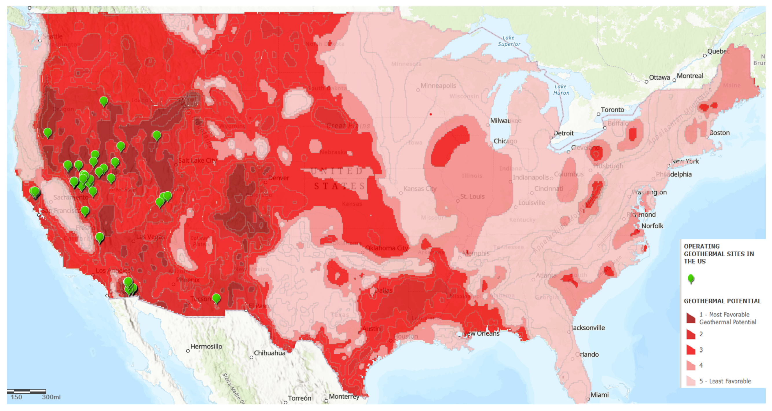
4.1. Geothermal Potential

Figure 1 shows the initial GIS shapefile that illustrates the geothermal potential of the entire United States via a heatmap where darker red represents more potential and lighter red represents less potential. This initial shape is later filtered to only show the targeted states: Arizona, New Mexico, Texas, Louisiana, Nevada, Mississippi, Arkansas, and Oklahoma. Figure 1 also details the five-category geothermal classification system that reflects the economic feasibility of geothermal development.
In addition to identifying potential geothermal resources, Figure 1 also shows the locations of currently operational geothermal plants using green pins. These sites collectively contribute approximately 2.5 GW of installed geothermal capacity. However, these resources utilize geothermal resources that are close to the surface, are naturally available from existing hot water reservoirs, and are not defined as enhanced geothermal systems (EGSs). However, these resources are limited.

4.2. Calculated Geothermal Land Area

Table 3 lists the different total land area for each land category for each geothermal class. The table also lists the number of oil wells in the selected area and the investigated categories. These data are visualized in the subsections below and were then used to calculate energy potential.

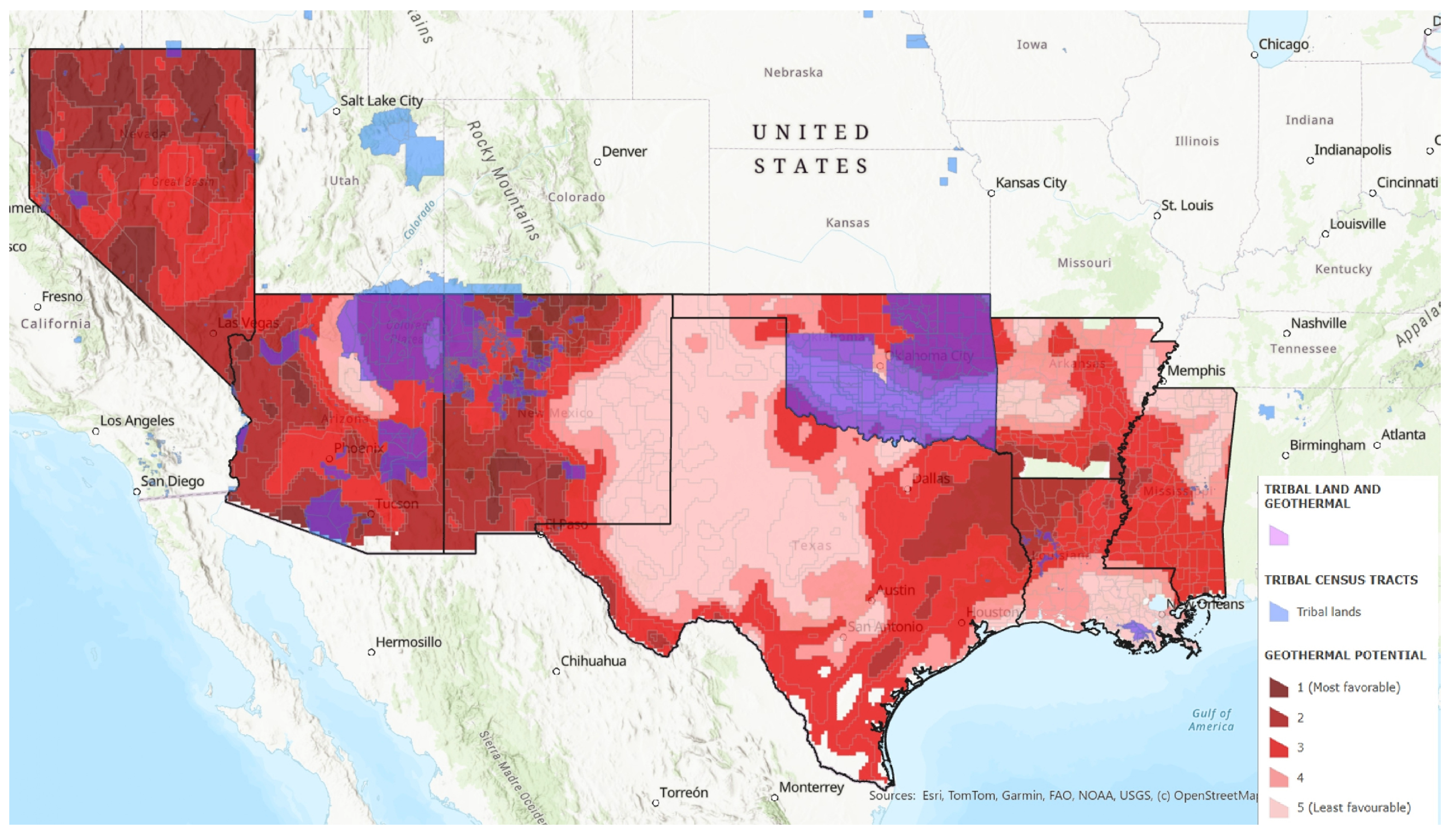
4.3. Tribal Lands and Geothermal Potential

Figure 2 displays all the tribal lands in the United States, and Figure 3 overlays the tribal lands in the study area with geothermal potential. Our analysis revealed that a significant portion of the identified high-potential geothermal area overlaps with tribal lands, particularly in Arizona, New Mexico, and Oklahoma.
These findings are summarized below:
  • Arizona, New Mexico, and Oklahoma: These states feature a majority of tribal states with geothermal sites (Class 1, Class 2, and Class 3). These areas should be prioritized for further feasibility studies, with active collaboration with local indigenous communities.
  • Arkansas, Texas, and Louisiana: These states have large amounts of high-potential geothermal sites. However, they have few or no tribal lands.
  • Nevada: As a known geothermal hotspot, Nevada’s Class 1 areas provide significant potential for geothermal energy, but not on tribal lands.

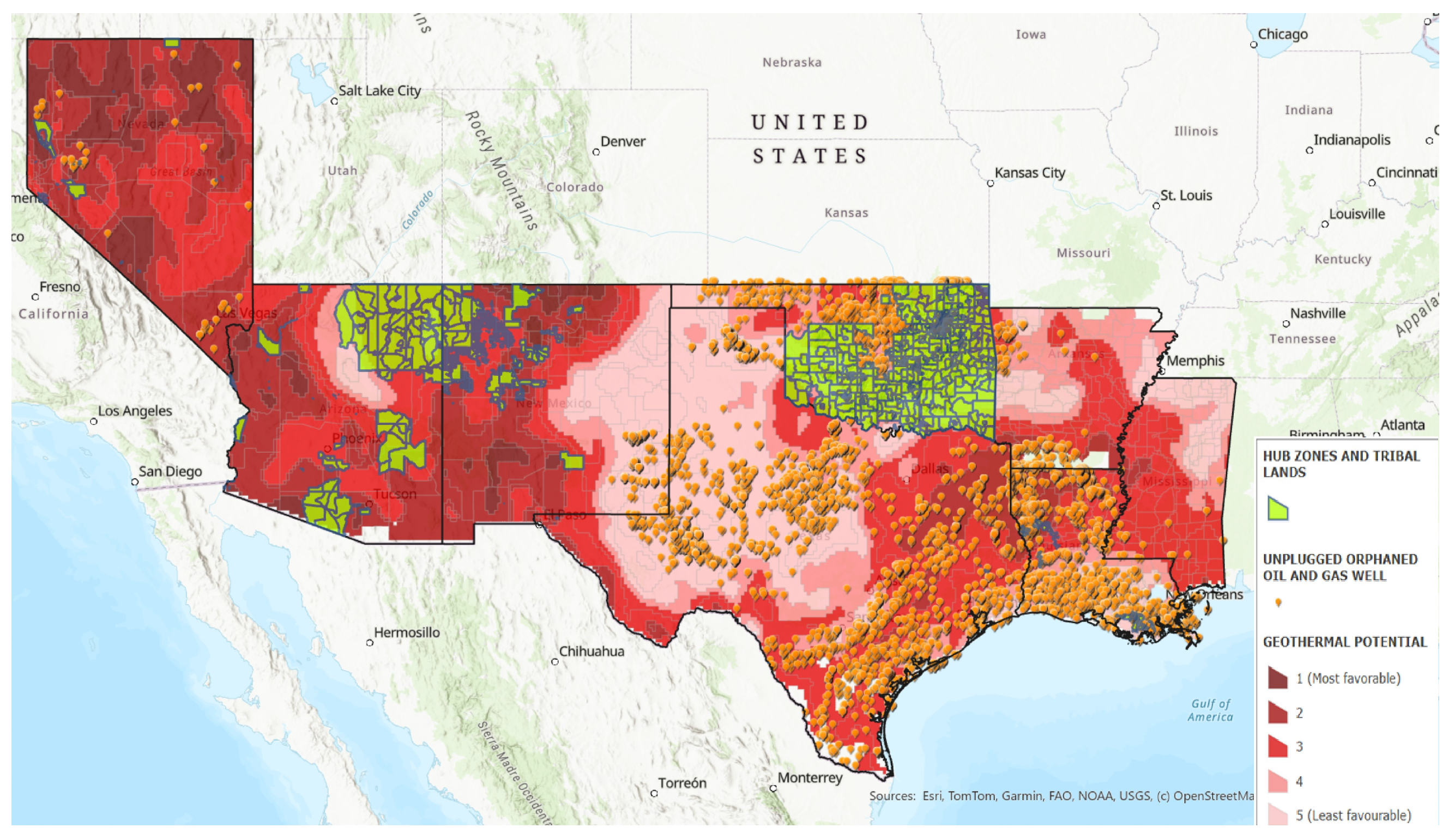
4.4. HUBZones and Geothermal Potential

Figure 4 offers a complete view of the suitable geothermal sites in the study area categorized into several classes overlaid with the HUBZone and tribal land census tracts (using Justice40 GIS data as a proxy). Geothermal suitability is divided into five main classes, each represented by a variant of red color. The outline of the census tracts are shown with thick black lines. Then, the census tracts that have significant geothermal potential (defined as having at least Class 1, 2, or 3) are shown in blue. The overlap represents an opportunity to advance priorities in those development zones where geothermal resources fall under both community importance and environmental justice. These opportunities are spread out through all the states in the target area, and developing these geothermal resources could have significant and profound socioeconomic impacts.

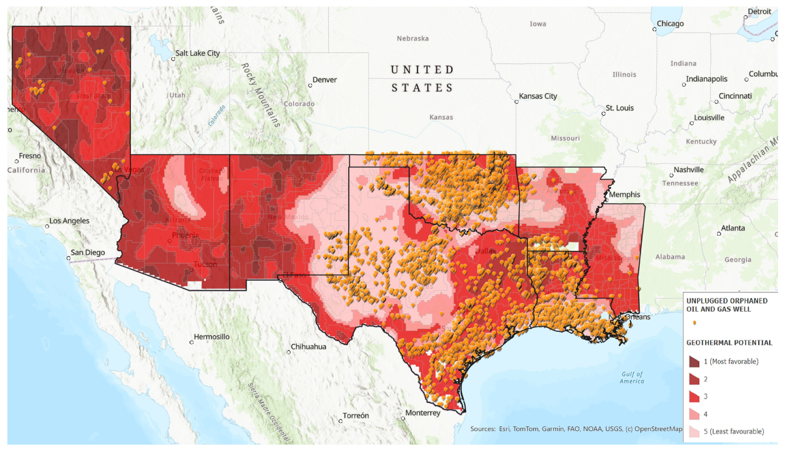
4.5. Orphaned Oil and Gas Wells

Figure 5 overlays geothermal potential with the orphaned oil wells in the study area. Areas with high geothermal potential are represented in red, and the orphaned oil wells are indicated using orange dots. From this, we can observe that many orphaned wells are located in areas with medium to high geothermal potential (dark red to pink regions), especially in Texas, Nevada, Oklahoma, and Louisiana. This figure reveals a significant overlap between high-potential geothermal zones and orphaned well locations, suggesting opportunities to repurpose these wells for renewable energy projects.

4.6. Tribal Lands, Orphaned Oil and Gas Wells, and Geothermal Potential

Figure 6 shows the intersection of geothermal potential in shades of red, with darker red indicating higher potential, existing orphaned oil well infrastructure shown in orange dots, and tribal lands (shown in green) indicating priority regions for equity in development. This map demonstrates that orphaned wells and tribal lands mainly overlap in Oklahoma and Louisiana, both areas that have moderate to high geothermal potential.

4.7. HUBZones, Tribal Lands, Orphaned Oil and Gas Wells, and Geothermal Potential

Figure 7 integrates the GIS layers’ geothermal potential (graded by favorability in shades from dark red to pink), U.S. documented unplugged orphaned oil and gas wells (orange dots), HUBZones, and tribal lands (shown in blue). The visualization emphasizes regions where geothermal potential intersects with existing infrastructure, HUBZones, and tribal lands, particularly in Texas, Nevada, and parts of the Southwest. The map highlights areas where there is significant potential to repurpose abandoned fossil fuel infrastructure and convert it into a renewable resource, aligning with energy and environmental goals.

4.8. Potential Geothermal Capacity

Based on existing work and data from geothermal energy studies, as well as insights from the Fervo pilot program [70,71,72], we were able to create estimates for energy capacity by geothermal class. We calibrated this information using multiple sources to create bounds for our estimates [40,46,68,69].
We assume that these sites would use enhanced geothermal system (EGS) technology that can extract usable heat from lands with underground temperatures of 120 °C or more between 3 and 6 km underground. We calculated power density (MW/km2) using Equation (2) to determine the potential capacity for a conventional EGS with a 10 km2 reservoir, and then, with 500 m buffers, the maximum number of facilities and total geothermal capacity for each land category is calculated and shown in Table 4.
Table 4 shows that there is significant geothermal potential in the selected area, totaling 2372.8 GW, with 765.8 GW available in HUBZones and 347.2 GW in tribal lands. Furthermore, converting abandoned oil wells which have already been drilled to geothermal plants could yield over 4 GW of capacity with 1.8 GW in HUBZones and 1.7 GW in tribal lands.
Table 5 shows the maximum number of geothermal facilities that could be ideally placed in the target area. Even when only considering Class 1 geothermal potential, there is the potential for 7696 geothermal facilities that produce nearly 44.08 MW per plant, with 2423 of these potential facilities being in HUBZones and 441 in tribal lands. These numbers increase significantly when taking into consideration Class 2 and 3 locations, even though the average geothermal plant capacity will decrease for these classes because of lower underground temperatures.

5. Discussion

We found that tribal lands and HUBZones have significant geothermal resources and extraction potential. The analysis revealed high geothermal potential, especially in Nevada, Texas, and New Mexico, with a significant overlap between significant geothermal areas and tribal lands. Furthermore, tribal lands and HUBZones have significant overlap, allowing them to take advantage of multiple policy efforts, like the IEPP. The legacy of fossil fuels in these communities, which has historically undermined environmental justice efforts, now presents an opportunity for revitalization, as abandoned oil and gas wells in these communities could be leveraged for new benefits. The resources identified in this study could produce billions in revenues, eliminate energy poverty, and provide energy justice to these communities. However, the history of these communities capitalizing on these benefits is stark.
This approach reframes energy transition as both an economic revitalization strategy and a tool for environmental remediation. Given the historical exploitation of indigenous lands by the fossil fuel industry, geothermal projects can serve as both a corrective measure and a future-oriented solution, offering direct economic benefits, infrastructure investment, and long-term tribal sovereignty. Federal mechanisms, including the IEPP and incentives for brownfield redevelopment, provide a pathway for tribes to lead in clean energy production, while addressing systemic issues of energy poverty, economic exclusion, and infrastructure gaps.

5.1. The Indian Energy Purchase Preference: A Long-Delayed Mechanism for Advancing Geothermal Development

The implementation of the Indian Energy Purchase Preference (IEPP) in 2024, nearly 20 years after its authorization under the Energy Policy Act of 2005, highlights both the potential and the persistent shortcomings in federal efforts to integrate tribal nations into the clean energy economy. While the IEPP is a significant step toward empowering tribal energy businesses, its delayed implementation underscores a broader pattern of neglect that has hindered economic development in Indian Country. For nearly two decades, the missed opportunity for action has left the immense geothermal potential of tribal lands untapped, an oversight that has slowed progress both in U.S. energy independence and tribal economic sovereignty.
Geothermal energy, with its ability to generate consistent and reliable power, presents an ideal application of the IEPP. Our results show that tribal nations in the Southwest, where geothermal resources coincide with HUBZones and orphaned fossil fuel infrastructure, are well positioned to lead projects that meet both local economic development goals and broader national energy demands. The IEPP’s recent pilot program, which prioritizes energy purchases from tribal majority-owned enterprises, is a necessary corrective, but its late implementation raises questions about missed opportunities for collaboration over the past two decades.
If implemented effectively, geothermal projects under the IEPP could repurpose orphaned oil and gas wells into sustainable energy sources, creating jobs, addressing environmental hazards, and establishing steady revenue streams for tribal communities. However, the slow adoption of this policy has limited its potential impact, leaving Tribal nations to shoulder the economic and environmental burdens of delayed federal action. The success of geothermal development under the IEPP will depend on robust and timely follow-through, with greater federal support to ensure that tribal sovereignty is not just acknowledged but actively upheld. This includes streamlining regulatory processes, expanding financial incentives, and ensuring equitable resource sharing as geothermal energy becomes a critical component of the clean energy transition.

5.2. Limitations of the Study

The accuracy of the geothermal site suitability mapping is dependent on the availability and quality of spatial data, including information on tribal lands and historical land use. This study is limited to the criteria included in the analysis and does not account for all possible factors, such as economic feasibility and detailed environmental impact assessments. Future research may need to incorporate additional factors and conduct on-the-ground validation to refine and enhance the suitability assessments. Our calculations for energy production are based on rough estimates of underground temperature and estimates for energy production use values in the literature that may not reflect the real world. However, we aimed to be conservative in our estimates to reflect this fact.

6. Conclusions

This study utilized Geographic Information System (GIS) tools to identify and assess geothermal potential across the South and Southwestern states of the USA, with a specific focus on tribal lands and HUBZones. The methodology employed GIS spatial data analysis, incorporating layers representing geothermal potential, tribal lands, and other relevant geographical and environmental data. The primary states of interest were Arizona, New Mexico, Texas, Louisiana, Nevada, Mississippi, Arkansas, and Oklahoma. The classification system for geothermal sites ranged from Class 1 (most favorable) to Class 999 (unsuitable for traditional geothermal energy extraction).
We calculated that there are 372,309 square miles with significant geothermal potential (120 °C and above) with the technical potential to produce 2328 GW in the target area. Furthermore, 122,917 square miles of land with significant geothermal potential are in HUBZones, and these lands have a technical potential of 765.8 GW. Another 60,696 square miles of land with significant geothermal potential are on tribal lands, with a technical potential of 347.2 GW. Furthermore, there are 18,520 abandoned oil wells in the selected area, with 7163 in HUBZones and 6166 in HUBZones on lands with significant geothermal potential. If these wells were converted to geothermal plants, they would have a capacity of 3 GW with over 1.7 GW in HUBZones and tribal lands.

Future Work and Study Significance

Future research can explore the on-the-ground validation of the identified sites, economic feasibility studies, and detailed environmental impact assessments. These analyses will be necessary to ensure that geothermal projects are both viable and sustainable. Furthermore, continued engagement with tribal communities will be crucial in ensuring that geothermal development aligns with indigenous values and contributes to local economic growth.
This study evaluated not only the energy potential of geothermal with respect to tribal lands and HUBZones but also investigated how to use repurposed abandoned fossil infrastructure to pursue clean energy goals. Therefore, the main contribution of this study was illustrating how energy development, specifically enhanced geothermal clean energy development, can be used as a tool for economic revitalization (e.g., job creation and energy revenues), energy development, and environmental remediation by transforming existing fossil assets into clean energy producers.

Author Contributions

Conceptualization, E.C.J.J. and A.R.; methodology, E.C.J.J.; validation, E.C.J.J. and R.A.; formal analysis, C.M.S. and R.A.; data curation, C.M.S. and R.A.; writing—original draft preparation, C.M.S.; writing—review and editing, E.C.J.J., A.R. and R.A. All authors have read and agreed to the published version of the manuscript.

Funding

This research received no external funding.

Data Availability Statement

Data from this research are available ArcGIS online via this link: https://arcg.is/0OWujj, accessed on 24 January 2025.

Conflicts of Interest

The authors declare no conflicts of interest.

References

  1. U.S. Department of Energy. Geothermal Basics. 2021. Available online: https://www.energy.gov/eere/geothermal/geothermal-basics (accessed on 24 January 2025).
  2. Horne, R.; Genter, A.; McClure, M.; Ellsworth, W.; Norbeck, J.; Schill, E. Enhanced geothermal systems for clean firm energy generation. Nat. Rev. Clean Technol. 2025, 1, 148–160. [Google Scholar] [CrossRef]
  3. Caulk, R.A.; Tomac, I. Reuse of abandoned oil and gas wells for geothermal energy production. Renew. Energy 2017, 112, 388–397. [Google Scholar] [CrossRef]
  4. The White House. Declaring a National Energy Emergency; The White House: Washington, DC, USA, 2025.
  5. U.S. Small Business Administration. HUBZone Program; U.S. Small Business Administration: Washington, DC, USA, 2025. Available online: https://www.sba.gov/federal-contracting/contracting-assistance-programs/hubzone-program (accessed on 24 January 2025).
  6. U.S. Department of the Interior. Orphaned Wells. 2025. Available online: https://www.doi.gov/orphanedwells (accessed on 24 January 2025).
  7. Jillian Neuberger, T.C.; Saha, D. How the US Can Address Legacy Fossil Fuel Sites for a Clean Energy Future. 2021. Available online: https://www.wri.org/insights/addressing-us-legacy-fossil-fuel-infrastructure (accessed on 24 January 2025).
  8. IRS. Clean Electricity Production Credit. 2025. Available online: https://www.irs.gov/credits-deductions/clean-electricity-production-credit (accessed on 24 January 2025).
  9. IRS. Clean Electricity Investment Credit. 2025. Available online: https://www.irs.gov/credits-deductions/clean-electricity-investment-credit (accessed on 24 January 2025).
  10. US Department of Energy. Indian Energy Purchase Preference—Background and Resources. 2025. Available online: https://www.energy.gov/indianenergy/indian-energy-purchase-preference-background-and-resources (accessed on 24 January 2025).
  11. Ricks, W.; Voller, K.; Galban, G.; Norbeck, J.H.; Jenkins, J.D. The role of flexible geothermal power in decarbonized electricity systems. Nat. Energy 2024, 10, 28–40. [Google Scholar] [CrossRef]
  12. Castelvecchi, D. Geothermal power is vying to be a major player in the world’s clean-energy future. Nat. Rev. Clean Technol. 2024, 635, 794–795. [Google Scholar] [CrossRef] [PubMed]
  13. Lazard. Lazard’s Levelized Cost of Energy Analysis; Version 17.0; With Support from Roland Berger; Lazard: Hamilton, Bermuda, 2024. [Google Scholar]
  14. Kwon, Y.S.; Li, Y.; Huang, B. Scalable, Low-Cost Fabrication of Selective Solar Absorber by Ultrasonic Spray Coating. ES Mater. Manuf. 2023, 20, 812. [Google Scholar] [CrossRef]
  15. Fauzi, F.N.; Puryantini, N.; Prabowo, A.R.; Adiputra, R.; Carvalho, H.; Danardono, D.; Tjahjana, D.P.; Firdaus, N.; Jurkovič, M. Implementation Assessment of the Offshore Wind Turbine (OWT) for Remote Regions’ Electrification in Indonesia Based on Geographical Potential and Economic Attractiveness. Eng. Sci. 2024, 32, 1295. [Google Scholar] [CrossRef]
  16. Massachusetts Institute of Technology. The Future of Geothermal Energy. 2006. Available online: https://energy.mit.edu/wp-content/uploads/2006/11/MITEI-The-Future-of-Geothermal-Energy.pdf (accessed on 24 January 2025).
  17. Sharmin, T.; Khan, N.R.; Akram, M.S.; Ehsan, M.M. A State-of-the-Art Review on Geothermal Energy Extraction, Utilization, and Improvement Strategies: Conventional, Hybridized, and Enhanced Geothermal Systems. Int. J. Thermofluids 2023, 18, 100323. [Google Scholar] [CrossRef]
  18. Liu, J.; Shao, C.; Yang, B.; Ngata, M.R.; Mwangomba, M.; Josephat, S.; Aminu, M.D. Advances in enhanced geothermal systems: Integrating laboratory, numerical and field insights. Appl. Therm. Eng. 2024, 249, 123350. [Google Scholar] [CrossRef]
  19. Augustine, C. Update to Enhanced Geothermal System Resource Potential Estimate; Technical Report NREL/CP-6A20-66428; National Renewable Energy Laboratory (NREL): Golden, CO, USA, 2016. [Google Scholar]
  20. Brookhart, T.; Batts, D.; Peterson, J. Geothermal Energy Resources and Policiesof the Western States; U.S. Bureau of Land Management: Washington, DC, USA, 2009. Available online: https://www.idahogeology.org/pub/Geothermal/References/Miscellaneous/Brookhart.etal-US.2009-GeothermalResourcesPoliciesWesternUS.pdf (accessed on 24 January 2025).
  21. Lynn Scarlett. Geothermal Energy. 2006. Available online: https://doi.gov/ocl/geothermal-energy (accessed on 24 January 2025).
  22. Haninger, K.; Ma, L.; Timmins, C. The Value of Brownfield Remediation. J. Assoc. Environ. Resour. Econ. 2017, 4, 197–241. [Google Scholar] [CrossRef]
  23. Bayer, P.; Rybach, L.; Blum, P.; Brauchler, R. Review on life cycle environmental effects of geothermal power generation. Renew. Sustain. Energy Rev. 2013, 26, 446–463. [Google Scholar] [CrossRef]
  24. Shortall, R.; Davidsdottir, B.; Axelsson, G. Development of a sustainability assessment framework for geothermal energy projects. Energy Sustain. Dev. 2015, 27, 28–45. [Google Scholar] [CrossRef]
  25. Bošnjaković, M.; Stojkov, M.; Jurjević, M. Environmental Impact of Geothermal Power Plants. Teh. Vjesn. 2019, 26, 1515–1522. [Google Scholar] [CrossRef]
  26. Kagel, A.; Gawell, K. Promoting Geothermal Energy: Air Emissions Comparison and Externality Analysis. Electr. J. 2005, 18, 90–99. [Google Scholar] [CrossRef]
  27. Speight, D.J. Geothermal Energy: Renewable Energy and the Environment, Second Edition, by William E. Glassley. Energy Sources Part A Recover. Util. Environ. Eff. 2015, 37, 2039. [Google Scholar] [CrossRef]
  28. U.S. Department of Energy. Apprentices Earn While They Learn to Build the Clean Energy Future; U.S. Department of Energy: Washington, DC, USA, 2022.
  29. Derse, O.; Yilmaz, E. Site selection optimization for 100% renewable energy sources. Environ. Sci. Pollut. Res. 2024, 31, 26790–26805. [Google Scholar] [CrossRef] [PubMed]
  30. Shao, M.; Han, Z.; Sun, J.; Xiao, C.; Zhang, S.; Zhao, Y. A review of multi-criteria decision making applications for renewable energy site selection. Renew. Energy 2020, 157, 377–403. [Google Scholar] [CrossRef]
  31. Jones, E.C.; Yaw, S.; Bennett, J.A.; Ogland-Hand, J.D.; Strahan, C.; Middleton, R.S. Designing multi-phased CO2 capture and storage infrastructure deployments. Renew. Sustain. Energy Transit. 2022, 2, 100023. [Google Scholar] [CrossRef]
  32. Jones, E.C. Lithium Supply Chain Optimization: A Global Analysis of Critical Minerals for Batteries. Energies 2024, 17, 2685. [Google Scholar] [CrossRef]
  33. Avtar, R.; Sahu, N.; Aggarwal, A.K.; Chakraborty, S.; Kharrazi, A.; Yunus, A.P.; Dou, J.; Kurniawan, T.A. Exploring Renewable Energy Resources Using Remote Sensing and GIS—A Review. Resources 2019, 8, 149. [Google Scholar] [CrossRef]
  34. Zinovieva, I.S.; Iatsyshyn, A.V.; Artemchuk, V.O.; Stanytsina, V.V.; Sheludchenko, L.S.; Popov, O.O.; Kovach, V.O.; Iatsyshyn, A.V. The use of GIS in renewable energy specialist’s learning. J. Phys. Conf. Ser. 2023, 2611, 012016. [Google Scholar] [CrossRef]
  35. Varekar, S.; Srinivasan, S.; Shah, N.; Gopalakrishnan, N.E., Jr. Analyzing the Connectivity of Combined Statistical Areas in Different Census Regions Using ArcGIS. Int. Supply Chain Technol. J. 2023, 9. [Google Scholar] [CrossRef]
  36. US Department of Energy. Tribal Electricity Access Reliability Report to Congress. 2024. Available online: https://www.energy.gov/sites/default/files/2024-01/EXEC-2023-000952%20-%20Tribal%20Electricity%20Access%20Reliability%20Report%20to%20Congress%20%28Final%20Draft%20-%20Clean%29-signed%20by%20S1.pdf (accessed on 24 January 2025).
  37. Bureau of Indian Affairs. Renewable Energy Development Program. 2024. Available online: https://www.bia.gov/bia/ots/demd/renewable-energy (accessed on 24 January 2025).
  38. Mara, K.; Zhang, N.; He, M. Tribal Financial Access to Renewable Energy: Full Report. 2024. Available online: https://foster.uw.edu/wp-content/uploads/2024/06/Tribal-Financial-Access-to-Renewable-Energy-Full-Report.pdf (accessed on 24 January 2025).
  39. Grosse, C.; Mark, B. Does renewable electricity promote Indigenous sovereignty? Reviewing support, barriers, and recommendations for solar and wind energy development on Native lands in the United States. Energy Res. Soc. Sci. 2023, 104, 103243. [Google Scholar] [CrossRef]
  40. Farhar, B.C. Geothermal Access to Federal and Tribal Lands: A Progress Report. 2002. Available online: https://www.osti.gov/servlets/purl/1216040 (accessed on 24 January 2025).
  41. Peter Meisen, T.E. Renewable Energy on Tribal Lands. Available online: https://www.geni.org/globalenergy/research/renewable-energy-on-tribal-lands/Renewable-Energy-on-Tribal-Lands.pdf (accessed on 24 January 2025).
  42. Farhar, B.C.; Dunlevy, P. Native American Issues in Geothermal Energy; U.S. Bureau of Land Management: Washington, DC, USA, 2009. Available online: https://www1.eere.energy.gov/tribalenergy/guide/pdfs/grc030707.pdf (accessed on 24 January 2025).
  43. Jones, E.C.; Reyes, A. Identifying Themes in Energy Poverty Research: Energy Justice Implications for Policy, Programs, and the Clean Energy Transition. Energies 2023, 16, 6698. [Google Scholar] [CrossRef]
  44. Pena Cabra, I.; Izar-Tenorio, J.; Sharma, S.; Clahane, L.; Iyengar, A.K. With uncertainty comes opportunity: Repurposing coal assets to create new beginnings in the U.S. Electr. J. 2024, 37, 107431. [Google Scholar] [CrossRef]
  45. Meenakshisundaram, A.; Tomomewo, O.S.; Aimen, L.; Bade, S.O. A comprehensive analysis of repurposing abandoned oil wells for different energy uses: Exploration, applications, and repurposing challenges. Clean. Eng. Technol. 2024, 22, 100797. [Google Scholar] [CrossRef]
  46. Blackwell, D.D.; Negraru, P.T.; Richards, M.C. Assessment of the Enhanced Geothermal System Resource Base of the United States. Nat. Resour. Res. 2007, 15, 283–308. [Google Scholar] [CrossRef]
  47. Mullane, M.; Gleason, M.; McCabe, K.; Mooney, M.; Reber, T.; Young, K.R. An Estimate of Shallow, Low-Temperature Geothermal Resources of the United States; Technical Report NREL/CP-6A20-66461; National Renewable Energy Laboratory (NREL): Golden, CO, USA, 2016.
  48. Augustine, C.; Fisher, S.; Ho, J.; Warren, I.; Witter, E. Enhanced Geothermal Shot Analysis for the Geothermal Technologies Office; Technical Report NREL/TP-5700-84822; National Renewable Energy Laboratory (NREL): Golden, CO, USA, 2023.
  49. Pinchuk, P.; Thomson, S.M.; Trainor-Guitton, W.; Buster, G.; Maclaurin, G. Development of a Geothermal Module in reV: Quantifying the Geothermal Potential While Accounting for the Geospatial Intersection of the Grid Infrastructure and Land Use Characteristics; National Renewable Energy Laboratory (NREL): Golden, CO, USA, 2021.
  50. Aljubran, M.J.; Horne, R.N. Power Supply Characterization of Baseload and Flexible Enhanced Geothermal Systems. Sci. Rep. 2024, 14, 17619. [Google Scholar] [CrossRef]
  51. USGS. U.S. Geothermal Systems Map. 2024. Available online: https://www.usgs.gov/media/images/us-geothermal-systems-map (accessed on 24 January 2025).
  52. Texas Department of Transportation. Texas County Boundaries. 2024. Available online: https://uta-arcgis.maps.arcgis.com/home/item.html?id=9b2eb7d232584572ad53bad41c76b04d (accessed on 24 January 2025).
  53. Nevada Legislative Counsel Bureau. Nevada Counties (Polygon). 2024. Available online: https://uta-arcgis.maps.arcgis.com/home/item.html?id=63ddb5c81799450fabd13439a81f0562 (accessed on 24 January 2025).
  54. U.S. Energy Information Administration. Renewable Energy Map Resource. 2024. Available online: https://uta-arcgis.maps.arcgis.com/home/item.html?id=6515281935cc4cc1afdd585358d0aee3 (accessed on 24 January 2025).
  55. U.S. Small Business Administration. HUBZone Map. 2025. Available online: https://maps.certify.sba.gov/hubzone/map# (accessed on 24 January 2025).
  56. Courtney Lindwall. What Is the Justice40 Initiative? 2023. Available online: https://www.nrdc.org/stories/what-justice40-initiative (accessed on 24 January 2025).
  57. The White House gov. Justice40 A Whole-of-Government Initiative. 2022. Available online: https://bidenwhitehouse.archives.gov/environmentaljustice/justice40/ (accessed on 24 January 2025).
  58. Esri US Federal Data. Tribal Census Tracts. 2024. Available online: https://uta-arcgis.maps.arcgis.com/home/item.html?id=fb1b067232314b719ae74fb5c4b94199 (accessed on 24 January 2025).
  59. USA 2020 Census Race and Ethnicity Characteristics—Tribal Geographies. U.S. Census Bureau’s Data. 2023. Available online: https://uta-arcgis.maps.arcgis.com/home/item.html?id=1f3ceb7f96464b329d1a8a64c787cd0c (accessed on 24 January 2025).
  60. Wilmarth, M.; Stimac, J. Power density in geothermal fields. Power 2015, 19, 25. [Google Scholar]
  61. Colin, F.; Williams, M.J.R.; Anderson, A.F. Updating the Classification of Geothermal Resources. 2011. Available online: https://www.energy.gov/eere/geothermal/articles/updating-classification-geothermal-resources (accessed on 24 January 2025).
  62. Wight, N.; Bennett, N. Geothermal energy from abandoned oil and gas wells using water in combination with a closed wellbore. Appl. Therm. Eng. 2015, 89, 908–915. [Google Scholar] [CrossRef]
  63. Santos, L.; Taleghani, A.D.; Elsworth, D. Repurposing abandoned wells for geothermal energy: Current status and future prospects. Renew. Energy 2022, 194, 1288–1302. [Google Scholar] [CrossRef]
  64. Zinsalo, J.M.; Lamarche, L.; Raymond, J. Performance analysis and working fluid selection of an Organic Rankine Cycle Power Plant coupled to an Enhanced Geothermal System. Energy 2022, 245, 123259. [Google Scholar] [CrossRef]
  65. Aydin, H.; Yüksel, S.; Topuz, C. Utilization of Oil and Gas Wells for Geothermal Applications. In Proceedings of the 49th Workshop on Geothermal Reservoir Engineering, Stanford University, Stanford, CA, USA, 12–14 February 2024. [Google Scholar]
  66. Al-Weshahi, M.A.; Latrash, F.; Anderson, A.; Agnew, B. Working fluid selection of low grade heat geothermal Organic Rankine Cycle (ORC). Int. J. Therm. Technol. 2014, 4, 6–14. [Google Scholar]
  67. Akhmadullin, I. Utilization of Co-Produced Water from Oil Production: Energy Generation Case. In Proceedings of the SPE Health Safety, Security, Environment, & Social Responsibility Conference-North America, New Orleans, LA, USA, 18–20 April 2017; p. D031S017R003. [Google Scholar]
  68. Geothermal|Electricity|2024|ATB|NREL. Available online: https://atb.nrel.gov/electricity/2024/geothermal (accessed on 24 January 2025).
  69. Lopez, A.; Zuckerman, G.R.; Pinchuk, P.; Gleason, M.; Rivers, M.; Roberts, O.; Williams, T.; Heimiller, D.; Thomson, S.M.; Mai, T.; et al. Renewable Energy Technical Potential and Supply Curves for the Contiguous United States, 2024th ed.; National Renewable Energy Laboratory (NREL): Golden, CO, USA, 2025.
  70. DiGangi, D. Interior Approves 2-GW Fervo Energy Geothermal Project in Utah. 2024. Available online: https://www.utilitydive.com/news/interior-geothermal-fervo-energy-categorical-exclusion-nepa/730413/ (accessed on 24 January 2025).
  71. Ritzinger, B.; Glen, J.; Peacock, J.; Blakely, R.; Mills, P.; Staisch, L.; Bennett, S.; Sherrod, B. Geothermal Potential of the Umatilla Indian Reservation, Oregon: Evidence from Detailed Geophysical Investigations. 2018. Available online: https://pubs.usgs.gov/publication/70259533 (accessed on 24 January 2025).
  72. NREL. Developing Clean Energy Projects on Tribal Lands. 2013. Available online: https://www.nrel.gov/docs/fy13osti/57748.pdf (accessed on 24 January 2025).
Figure 1. Geothermal potential and existing geothermal plants.
Sustainability 17 02558 g001
Figure 2. Tribal lands in the United States.
Sustainability 17 02558 g002
Figure 3. Geothermal potential and tribal lands.
Sustainability 17 02558 g003
Figure 4. Geothermal potential, tribal lands, and HUBZones.
Sustainability 17 02558 g004
Figure 5. Geothermal potential and orphaned oil and gas wells.
Sustainability 17 02558 g005
Figure 6. Geothermal potential, tribal lands, and orphaned oil and gas wells.
Sustainability 17 02558 g006
Figure 7. Geothermal potential, tribal lands, HUBZones, and orphaned oil and gas wells.
Sustainability 17 02558 g007
Table 1. Temperature range by geothermal class.
ClassTemperature Range (°C)
Class 1>150 °C
Class 2130–150 °C
Class 3110–130 °C
Class 490–110 °C
Class 5<90 °C
Class 999No temperature data
Table 2. Comparison of key performance indicators.
Parameter (Unit)Chena Alaska ORC Unit [66]Simulation Analysis [67]This Study
RefrigerantR134aR134aR134a
Heat source temperature inlet (°F)164164164
Turbine inlet pressure (bar)161616
Turbine outlet pressure (bar)4.394.394.39
Refrigerant flow rate (kg/s)12.211.6512
Gross power production (kW)250263.85249
Cycle efficiency (%)8.28.519
Table 3. Calculated land area by geothermal class and land type.
ClassTotal Land Area
(Sq. Mi.)
HUBZones
Land Area (Sq. Mi.)
Tribal Lands
(Sq. Mi.)
Oil Wells
(#)
# of Oil Wells in
HUBZones (#)
# of Oil Wells
in Tribal Communities
132,05010,09018382010
2144,14138,77610,832220020122
3196,11874,05148,02612,00059645752
4221,51322,64118,7292000334290
5236,16031,32018,8452300663370
Total829,982176,87898,27018,52071636434
Table 4. Technical geothermal potential capacity of selected area and investigated categories.
ClassTotal
Potential (GW)
HUBZones (GW)Tribal
Lands (GW)
Oil
Wells (GW)
Oil Wells (GW) in
HUBZones
Oil Wells (GW)
on Tribal Lands
Class 1339.3106.819.40.00.00.0
Class 21002.6269.775.30.70.10.0
Class 31031.0389.3252.53.51.81.7
Total2372.8765.8347.24.31.81.7
Table 5. Maximum Number of Potential Geothermal Facilities in the Selected Area and by Investigated Categories.
ClassMax Potential
Facilities
Hub Zones
Max Facilities
Tribal Lands
Max Facilities
Average Plant
Capacity (MW)
Class 17696242344144.08
Class 234,6139311260128.97
Class 347,09517,78211,53221.89
Total89,40429,51614,57494.94
Disclaimer/Publisher’s Note: The statements, opinions and data contained in all publications are solely those of the individual author(s) and contributor(s) and not of MDPI and/or the editor(s). MDPI and/or the editor(s) disclaim responsibility for any injury to people or property resulting from any ideas, methods, instructions or products referred to in the content.

