Abstract
In recent years, the concepts of sustainability and sustainable development of transport infrastructure have been examined mainly from an economic, ecological, and social perspective. However, an essential aspect of the sustainability of the Trans-European Transport Networks (TEN-T) land infrastructure is also the construction and technical parameters of critical infrastructure objects. For this reason, the aim of the article is to define recommendations for the sustainability and future development of the TEN-T land infrastructure. For this purpose, the article presents the procedure for defining and modelling typical transport situations using the TEN-T land infrastructure and the procedure for identifying critical infrastructure objects of the TEN-T land infrastructure. Attention is also paid to the digitalization of critical infrastructure objects, which categorizes infrastructure according to its suitability for excessive and oversized transport using map data. The main output of the article are recommendations for the sustainability and future development of the TEN-T land infrastructure. These recommendations are based on the systematic development of TEN-T in four basic layers, namely legislative, capatitive, construction-technical, and technological. These recommendations are intended primarily for the Ministry of Defence of the Czech Republic and the Ministry of Transport of the Czech Republic, but also for transport infrastructure operators, i.e., Road and Motorway Directorate and Railway Infrastructure Administration.
1. Introduction
Transport is a significant sector of European Critical Infrastructure, which is listed together with ten other sectors in the Directive (EU) on the resilience of critical entities [1]. This Directive points out the importance of predictable transportation, which can be perceived both at the construction-technical and capacity levels. The most important part of the land transport infrastructure can be considered the Trans-European Transport Networks (TEN-T). In the current situation, the essence of this transport network is to connect EU regions, support the growth of the internal market and employment, and strengthen social, economic and territorial cohesion [2]. However, TEN-T can also be used to address large-scale disasters, and it is, therefore, necessary to consider the duality of its use, as stated in the EU’s Strategic Compass for Security and Defence [3].
In recent years, European territory has been increasingly exposed to threats resulting in large-scale disasters [4]. Examples include the extensive floods in the Czech Republic (2002), the earthquakes in Italy (2009) and Greece (2020), the COVID-19 pandemic (2020–2023), the tornado in the Czech Republic (2021), and the war in Ukraine (2022–present). At the same time, it should be noted that in connection with climate change, a further increase in natural disasters is predicted in the coming ten years [5].
In the fight against large-scale disasters, measures are implemented on both the prevention and response sides. While the prevention of these disasters is based primarily on risk management [6,7], crisis management information systems [8] and disaster management logistics [9] play a significant role in mitigating these disasters. Disaster logistics can be seen as a support function that ensures the timely delivery of emergency supplies and rescue services to disaster-affected areas [10].
The transport of these emergency supplies, especially in an international context, can be carried out in four basic ways: by air, by waterway, by rail, or by road. In all cases, the Trans-European Transport Networks (TEN-T) are useful [11], which include infrastructures enabling fast and efficient international transport. However, in the case of transport of excessive and oversized goods, it is advisable to use the TEN-T land infrastructure as a priority [12].
From the above, it is clear that an essential aspect of the long-term functionality of the TEN-T land infrastructure is its sustainability. Sustainable transport is one of the global goals of sustainable development, which is important not only for economic growth, but also for ensuring accessibility [13]. The sustainability of accessible transport infrastructure is an important factor not only in everyday life, e.g., for the healthcare system [14] or the economy [15], but also in the event of global crises [16].
The new Regulation (EU) of the European Parliament and of the Council emphasizes that the European transport corridors should facilitate the development of the TEN-T infrastructure, which focuses on addressing bottlenecks, improving cross-border connections and increasing efficiency and sustainability [2]. In this context, it can be stated that this sustainability should be based on the continuous development of transport infrastructure, considering the specifics of dual use [3]. The dual or multiple use of the TEN-T land infrastructure (i.e., by the civilian sector, components of the integrated rescue system and armies—both national and NATO) has a fundamental impact on the capacity utilization of the transport infrastructure in question.
In recent years, the concepts of sustainability and sustainable development of transport infrastructure have been examined mainly from an economic [17,18,19], environmental [20,21,22], and social [23,24,25] perspective. However, in the context of the long-term usability of the TEN-T land infrastructure, it is also necessary to pay attention to the construction-technical aspects of sustainability [26,27,28]. Based on these facts, the aim of the article is to define recommendations for the future development of the TEN-T land infrastructure. These recommendations will be based on the results of (1) defining and modelling the typical transport situations using the TEN-T land infrastructure and (2) defining critical infrastructure objects of the TEN-T land infrastructure.
In the context of the above-mentioned objective, the article is structured into two comprehensive sections, i.e., Materials and Methods, and Results. The first section provides a description of the TEN-T land infrastructure in the Czech Republic, a description of large-scale disasters resulting in above-standard use of the TEN-T land infrastructure, and a description of the methods used for modelling and digitizing routes for excessive and oversized transport. The second section presents the key results of the article. Within this section, typical transport situations using the TEN-T land infrastructure are defined and modelled, a procedure for identifying critical infrastructure objects of the TEN-T land infrastructure is created, a procedure for digitizing critical infrastructure objects of the TEN-T land infrastructure is presented, and recommendations for the sustainability and future development of the TEN-T land infrastructure in the context of military mobility are defined.
2. Materials and Methods
The purpose of this part of the article is to familiarize the reader with the materials and methods used. For this purpose, in relation to the thematic focus of the article, the TEN-T land infrastructure, large-scale disasters resulting in above-standard use of the TEN-T land infrastructure, and tools for transport modelling and identification of critical infrastructure objects are presented.
2.1. TEN-T Land Infrastructure in the Czech Republic
The establishment and development of Trans-European Networks was enshrined in the Maastricht Treaty in 1992 [29]. Support for this development concerned networks for (1) energy and telecommunications, and (2) transport. The Trans-European Transport Networks (TEN-T) are networks of road and rail corridors, international airports and waterways created to improve the quality and connectivity of transport infrastructure in the European Union [30]. This transport network is defined as two-layer and consists of comprehensive and core networks [31]. The comprehensive network ensures multimodal connectivity of all European regions, while the core network represents a subset of the comprehensive network and contains the most important trans-European routes.
The road and rail corridors are collectively referred to as the TEN-T land infrastructure and, according to the European Directive [1], are referred to as critical infrastructure elements. The infrastructure elements (objects) of this land infrastructure can be classified into three groups according to their topological structure [32,33]:
- Line elements—ensure the transfer, delivery, or transport of goods between two physically separate locations (e.g., road and rail corridors). They are a meaningful basic group that is in relation to all point and area elements (the length dimension is an order of magnitude greater than the width dimension).
- Point elements—represent a concentrated and closed unit located on a small area, which fulfils its function for the needs of specific line objects (e.g., bridges, tunnels), (length and width are negligible compared to line and area elements).
- Area elements—represent one unit or integral objects, where two or more point elements or two or more key technologies occur (e.g., significant transport hubs).
The Czech Republic is an important region in terms of the sustainability of European road and rail transport, as it plays the role of a transit country [34]. For this purpose, linear elements of the TEN-T land infrastructure are used, i.e., road and rail corridors. A description of these corridors is given in the following text.
The TEN-T road transport network currently includes motorways (see Figure 1) and some sections of class I roads in the Czech Republic. Other sections are currently under construction.

Figure 1.
Motorways in the Czech Republic [35].
There are 17 motorways built in the Czech Republic with a total length of 1394 km (as of 1 July 2024). Of these, only D1, D2, D3, D5, D8, and D11 were originally built as motorways and are classified as class I motorways. The rest of the motorways were originally expressways, which were converted to class II motorways in 2016. Class I roads, which are part of the TEN-T network, total 91,028 km [36].
These TEN-T road corridors also include point and area elements. The point elements include tunnels and bridges. Specifically, there are 22 tunnels and 1871 bridges on motorways. The area elements include selected level crossings.
The TEN-T railway transport network currently includes four transit corridors in the Czech Republic (see Figure 2). A further 839 km of high-speed lines should be in operation by 2050 [37].
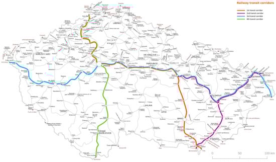
Figure 2.
Railway transit corridors in the Czech Republic [38].
All four rail transit corridors have a total length of 1286 km [39]. The first corridor runs from Germany to Austria via Děčín—Prague—Česká Třebová—Brno—Břeclav. The total length of this corridor is 458 km, of which 379 km are inside the corridor and 79 km are outside the corridor. The second corridor runs from Austria to Poland via Břeclav—Přerov—Ostrava. The Přerov—Česká Třebová section also belongs to this corridor. The total length of this corridor is 313 km, of which 7 km are within the first corridor. The third corridor runs from Germany to Slovakia via Cheb/Domažlice—Plzeň—Prague—Česká Třebová—Ostrava—Bohumín/Havířov. The total length of this corridor is 665 km, of which 370 km are inside the first and second corridors. The fourth corridor runs from Germany to Austria via Děčín—Prague—Veselí nad Lužnicí—Horní Dvořiště/České Velenice. The total length of this corridor is 365 km, of which 145 km are inside the first and third corridors.
These TEN-T rail transits also include point and area elements. Point elements include tunnels and bridges. For example, on the first transit corridor there are 14 tunnels and 697 bridges [39]. Area elements include major railway junctions and terminals.
2.2. Large-Scale Disasters Resulting in Above-Standard Use of TEN-T Land Infrastructure
Large-scale disasters can be defined from two perspectives. In terms of impact, they are defined as disasters that result in 100 to 1000 people being adversely affected (e.g., through displacement, injury or death) or the effects of these disasters cover 10 to 100 km2 [40]. Large-scale disasters with a death toll of 1000 people and an affected geographical area of 100 km2 can also be referred to as enormous or gargantuan disasters [41]. In terms of their management, they are defined as “types of disasters affecting a society which requires national or international assistance” [4]. It is clear from both definitions that dealing with such disasters requires extensive logistical support and, in some cases, the use of TEN-T land infrastructure.
The basic classification of large-scale disasters is made into two categories, which are natural and man-made disasters [42]. A more detailed classification of natural disasters is based on the Peril Classification [43], which includes six basic groups of hazards, namely geophysical, hydrological, meteorological, climatological, biological, and extraterrestrial. Unlike natural disasters, which are the result of natural hazards, man-made disasters have an element of negligence or human intent [44]. Such disasters include industrial accidents, terrorist acts, or armed conflicts.
The following section of the article defines large-scale disasters resulting in the above-standard use of the TEN-T land infrastructure. In this context, above-standard use is considered to be the movement of excessive or oversized transport [45] or overloading of the TEN-T land infrastructure capacities. The selection procedure for these disasters was divided into three phases (see Figure 3), which consider key criteria (i.e., excessiveness and over-dimensioning of equipment and infrastructure capacity) determining the above-standard use of TEN-T land infrastructure in managing large-scale disasters.
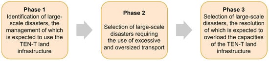
Figure 3.
Selection procedure for large-scale disasters resulting in above-standard use of TEN-T land infrastructure.
The first phase of the process focused on identifying large-scale disasters, the management of which is expected to involve the use of TEN-T land infrastructure. This identification was based on the Hazard Analysis for the Czech Republic [46]. In this document, a total of 72 types of hazards were identified and divided into six groups according to their nature: abiotic, biotic, cosmic, technogenic, sociogenic, and economic.
Another important material for identifying large-scale disasters, the management of which is expected to involve the use of TEN-T land infrastructure, was the EM-DAT Classification Tree [47]. This document currently monitors 77 natural and technological disasters, including the number of their occurrences in the years 1900–2023. Based on the results of this analysis, a total of 10 large-scale disasters were identified: riverine flood, flash flood, extreme wind, landslide, earthquake, tornado, industrial accident, large-scale migration wave, large-scale lawlessness, and armed conflict.
In the second phase, a selection of large-scale disasters requiring the use of excessive or oversized transport was carried out [45]. Based on the results of this selection, 6 large-scale disasters were selected: riverine flood, earthquake, tornado, industrial accident, large-scale migration wave, and armed conflict.
In the third phase, a selection of large-scale disasters was carried out, the resolution of which is expected to overload the capacities of the TEN-T land infrastructure. On the basic of the results of this selection, only one large-scale disaster was selected, namely an armed conflict requiring extensive deployment of NATO armies. In such a case, above-standard use of the TEN-T land infrastructure would be expected.
2.3. Description of the Methods Used for Modelling and Digitizing Routes for Excessive and Oversized Transport
To identify critical infrastructure objects of the TEN-T land infrastructure, transport models are used—typical transport situations. The created typical transport situations on the road are designed as basic variants and, thus, represent the most demanding possible “use” of the road infrastructure objects in question. The same road trains (with the exception of low-loaders) are further used analogously for modelling within the framework of rail transport. Transport models serve to reveal bottlenecks from a construction-technical perspective, as well as from a capacity perspective, with both perspectives intertwining and influencing each other.
The road transport model considers 4 variants that copy the “most problematic” land military equipment. The technical parameters of the selected equipment exceed the parameters of civilian equipment (e.g., construction machinery), and they also demonstrate the possibilities of using the TEN-T land infrastructure not only by the Czech Army, but also by the armies of NATO member states. In the rail transport model, variants 2–4 are combined into one due to the possibility of loading the ground military equipment in question into one military train.
Transport models—typical transport situations are created under the following conditions. Firstly, it concerns the construction of separate transport flows (convoys) according to the applicable legislation and standards, where the standard size of a convoy ranging from 4 to 20 vehicles. The convoys include vehicles that represent the greatest limitation for the monitored TEN-T land infrastructure and require its above-standard use or usually combine excessive and oversized transport. The transport model is created according to the Construction Concept of the Army of the Czech Republic 2030 [48], which includes a commitment to NATO to allocate a company task force consisting of 250 people, which represents the basic building block of larger units, i.e., battalion and brigade.
The considered company task force is, among other things, expected to be separated under the auspices of the United Nations in 2023–2025. In terms of the ground military equipment transported, it is a tank company, including accompanying vehicles. Vehicle streams and complete convoys are assembled according to the requirements [49], including vehicles for protection and defence, workshop, and recovery vehicles. Rest on Movement (ROM) and Rest on Night (RON) also play an important role in the requirements for the related infrastructure. These areas must provide construction-technical and capacity-appropriate options for parking, resupply, maintenance and minor repairs, and rest. Last but not least, the models are limited to the military movements of the ground military equipment in question, not of personnel, which are (standardly) addressed separately and are not the subject of this article.
Modelling these typical transport situations requires a systematic multi-phased approach that combines the use of large datasets and specialized methodologies. The Road Databank of the Directorate of Roads and Highways [50] is a key tool for ensuring efficiency, which contains vector data with parameters such as bridge load capacity, underpass clearance, road geometry, and other relevant road infrastructure elements. This data source allows the creation of a basic throughput model that identifies critical infrastructure objects of the transport network that are insufficient for a given transport. The first step in the process is the creation of a basic throughput model and a global analysis of typical transports on a digital road network model (road database). At this stage, automated modelling of the TEN-T network throughput takes place according to the parameters of typical transports, for example, convoys of Leopard 2A7V tanks on DOLL S8E low-loaders or recovery vehicles on a P-50 N low-loader. The automation of this stage allows the rapid identification of locations such as bridges with insufficient load capacity or underpasses with limited height that do not correspond to the parameters of the transported vehicles.
If the basic GIS model identifies non-compliant elements, a detailed calculation of the passability of these critical points is carried out using the STANAG 2021 methodology [51]. This methodology was developed for military purposes and provides an accurate assessment of the load-bearing capacity of bridges by determining the so-called Military Load Classification (MLC). The calculation considers the specific characteristics of military equipment, such as weight distribution on the axles and dynamic effects during transport. It also considers the current technical condition of the bridge, or rather the element to be solved. This document [51], on the one hand, defines hypothetical military vehicles divided into 16 categories with their geometric and weight characteristics, and on the other hand, it assigns a load class to bridge structures according to the category of a hypothetical vehicle that could still cross the bridge under given conditions. In reality, each military vehicle within NATO is assigned with a certain MLC number given by a hypothetical wheeled or tracked vehicle category according to the table in Annex A of AEP-3.12.1.5 [52].
Each existing or newly designed bridge can be assigned with a certain MLC number representing the load capacity of that particular bridge. If a vehicle has an MLC number less than or equal to the MLC loading capacity of a bridge under given passing conditions, can go through. Those conditions are normal crossing (similar to normal civil transport conditions), crossing with caution and risk crossing (single vehicle on bridge span and other limitations). In some cases, according to STANAG 2021 [51], heavier vehicles can pass the bridge, but with less reliability compared to the civil load capacity given by Eurocodes or similar documents, which is significantly advantageous in a crisis situation.
Modelling of traffic flow according to STANAG 2021 includes static and dynamic analyses of bridge structures, using data on material properties and the current technical condition of the structure [53]. The results of this analysis allow either to confirm the possibility of using the element for a given transport, or to identify the need for measures such as temporary bridge reinforcement, route adaptation, or modification of transport equipment. Also, only a limited number of passages of specific type of transport can be determined.
This two-phase approach, which first uses the Road Databank data for a multi-criteria assessment and then applies the STANAG 2021 methodology to potentially non-compliant elements, ensures the effectiveness of military transport planning. It allows for the rapid identification and resolution of potential problems and the design of measures, thereby minimizing time and financial costs while increasing the safety and sustainability of military operations on the TEN-T network and other roads.
3. Results
The essence of this part of the article is to present the results of the article with the aim of supporting the sustainability of the TEN-T land infrastructure to address large-scale disasters. For this purpose, attention is first paid to the definition and modelling of typical transport situations using the TEN-T land infrastructure. Subsequently, the procedure for defining critical infrastructure objects of the TEN-T land infrastructure is presented. At the end of the article, recommendations for the future development of the TEN-T land infrastructure are defined.
3.1. Defining and Modelling Typical Transport Situations Using TEN-T Land Infrastructure
The analyses revealed that from the perspective of construction-technical parameters, the greatest challenge is military movements of both the Czech Army and NATO in the context of Host Nation Support [54]. Especially in the event of the need to deploy NATO forces and assets on the eastern flank of the alliance (e.g., in the context of the Russian–Ukrainian conflict), in connection with the New NATO Force Model, the TEN-T land infrastructure would be exposed to very above-standard use both in terms of capacity [55] and from a construction-technical point of view [56]. The aforementioned multiple use of the TEN-T land infrastructure (civilian transport, including components of the integrated rescue system and national armies, as well as NATO) also plays a crucial role, which increases the likelihood of cascading effects [57].
Typical transport situations are further divided into separate transport sets (variants) according to the type of “problematic” vehicle in the set. The most important, in terms of the impact on the TEN-T land infrastructure, is the transport set—variant 1, which contains Leopard 2A7V tanks on DOLL S8E low-loaders with a MAN SLT70 tractor. Leopard tanks, including the latest 2A8 variants to be delivered in the future, will place the greatest demands on the above-standard use of the TEN-T land infrastructure, because they represent both excessive and oversized transport [58]. Accompanying vehicles in other variants such as the KN-251 wheel loader, the SPOT-55 firefighting vehicle, and the T-815-7 VV 8 × 8 recovery vehicle on P-50 N low-loaders with a T-815 8 × 8 tractor represent a capacity problem due to the need to create complete convoys that slow down traffic.
The same ground military equipment, identified in the typical transport situations above, is loaded onto suitable railway wagons, thus, creating a railway transport model in two variants. Variant 1 is analogous to the road transport model, while variants 2–4 can be loaded onto one military train. Other vehicles/elements designated as part of the transport set are also added. The transport set in variant 1 contains Leopard 2A7V tanks on a Samms wagon (or Res54), where the related limitation is the availability of Samms railway freight wagons, which are available in limited numbers and only abroad (e.g., in Germany with Deutsche Bahn). The set also includes a mobile car workshop and a recovery tank as standard. Transport sets in variants 2–4 consist of a KN-251 wheel loader with a dismantled cabin, a SPOT-55 firefighting vehicle after dismantling the mounted streamliner, and a T-815-7 VV 8 × 8 recovery vehicle. The transport set also includes security equipment—CAS 30 T-815-7 6 × 6 medium tank trucks, T-815-7 S3 trucks, UDS 214 T-815-7 universal finishing machine, T-815-7 mobile car workshop 8 × 8, and a recovery vehicle. The above-mentioned ground military equipment also requires special railway freight cars; however, there are more options, which are also available in the Czech Republic, e.g., Res54 at ČD Cargo.
3.2. Identification of Critical Infrastructure Objects of the TEN-T Land Infrastructure
Based on the definition and modelling of typical transport situations, it is possible to identify critical objects of the TEN-T land infrastructure. This identification can be based on modelling the impacts of the critical infrastructure failure [59], using cascading impact assessment [57], or factors influencing the performance of critical land transport infrastructure elements [60].
The outputs from these tools provide relevant information, but do not reflect the criticality of infrastructure objects in the context of their use for excessive and oversized transport. For this reason, a specific procedure was created, the output of which is an assessment of the suitability of infrastructure objects for these types of transport. The proposed identification procedure includes three phases (see Figure 4), which determine activities for assessing data that are the necessary basis for comparing the technical parameters of the convoy and the construction and technical parameters of the infrastructure. Within each phase, the inputs and outputs necessary for the process and the methods that are appropriate to use within a given phase are defined.
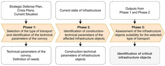
Figure 4.
Procedure for identifying critical infrastructure objects of the TEN-T land infrastructure.
3.2.1. Phase 1: Selection of the Type of Transport and Identification of the Technical Parameters of the Convoy
The starting point of this phase is the definition of the assessor’s needs, which result from defence and crisis plans. Based on these needs, it is first necessary to select the type of transport on the basis of which a specific convoy variant will be defined. For this convoy variant, the main technical parameters are then identified, which means the maximum passing widths and heights of all vehicles and vehicle combinations in the convoy and also the classification of all vehicles and vehicle combinations into MLC categories according to STANAG 2021 [51]. An example of the identification of technical parameters for one vehicle combination is presented in Figure 5.
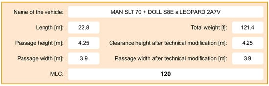
Figure 5.
Example of identification of technical parameters for a vehicle combination MAN SLT 70 + DOLL S8E a LEOPARD 2A7V.
The most complex technical parameter of a vehicle or vehicle combination is the determination of the MLC category. An example of the parameters of vehicles in the MLC categories is presented in Figure 6.
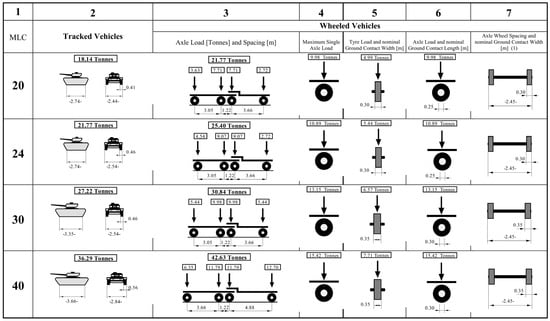
Figure 6.
Vehicle parameters in load class MLC 20 to MLC 40 according to STANAG 2021 [51].
The technical parameters of the convoy determined in this way are in the vast majority of cases fixed. Under specific circumstances, the clearance height and possibly the MLC class can be manipulated to a certain extent by appropriate distribution of the load in the vehicle combinations. For military vehicles within NATO, their MLC class is known, as is the case for some typical vehicle combinations. If the civilian vehicle or vehicle combination does not have an MLC class, it can be determined by calculation according to the procedure specified in STANAG 2021 [51].
3.2.2. Phase 2: Identification of Construction-Technical Parameters of the Affected Infrastructure Objects
This phase of the process involves selecting the affected infrastructure objects and identifying their construction-technical parameters that affect the capacity of the transport network. An example of identifying construction-technical parameters for a specific bridge structure is presented in Figure 7.
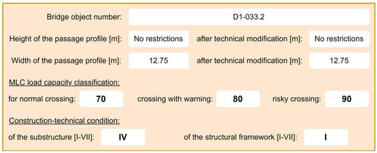
Figure 7.
Example of identification of construction-technical parameters for a bridge structure.
These parameters enter the next stages as limiting conditions, which are either temporary or permanent in nature and at the same time, according to the definition of the term construction-technical parameter, their value is constant or variable, discrete or continuous, often in a certain interval. Construction-technical parameters and the construction-technical condition of bridge structures can be obtained from the bridge sheet, which must exist for each bridge structure and is available in the bridge structure database and is regularly updated.
In addition, regular checks of the construction-technical condition of the bridge structure allow for an up-to-date overview of these parameters, and the construction-technical parameters and condition, thus, obtained are suitable for further computer processing and enter the next stages of the process, where they can be validated, if necessary, through an extraordinary inspection of the bridge.
Based on the information from the bridge sheet and regular checks, it is possible to determine the construction-technical condition of the substructure and structural framework of the bridge structure. According to the assessment results, the construction-technical condition of bridge structures is classified into seven levels (see Figure 8).
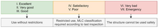
Figure 8.
Condition of buildings based on the substructure and structural framework conditions.
For other infrastructure objects such as underpasses and tunnels, the main technical parameters are the height and width of the passage profile, but it is true that underpasses and tunnels limit the transport capacity of the network only in a relatively small percentage of cases compared to bridge structures. For railway infrastructure objects, their construction-technical parameters are clearly given by the category of the line, and it is practically impossible to define railway transport that would not meet the criteria for a given line.
3.2.3. Phase 3: Assessment of the Infrastructure Objects Suitability for the Selected Type of Transport
This phase assesses the infrastructure objects suitability for the selected type of transport. This assessment consists of a comparison between the technical parameters of the convoy (see Phase 1) and the construction-technical parameters of the affected infrastructure objects (see Phase 2). The comparison must always be carried out individually, i.e., one vehicle or vehicle combination against one infrastructure object. The output of this phase is the identification of critical infrastructure objects of the TEN-T land infrastructure.
The assessed parameters are the clearance height, clearance width, MLC value, and the construction-technical condition of the bridge. Based on the results of the comparison, the infrastructure object is classified into three categories according to its suitability for the selected type of transport:
- green category: the object is suitable for the given transport;
- orange category: the object is suitable for the given transport after technical modification of the object or vehicle/train (e.g., dismantling of a certain part of it) and with increased attention;
- red category: the object is not suitable for the given transport.
The classification of an object into the above categories is carried out according to the criteria shown in Figure 9.
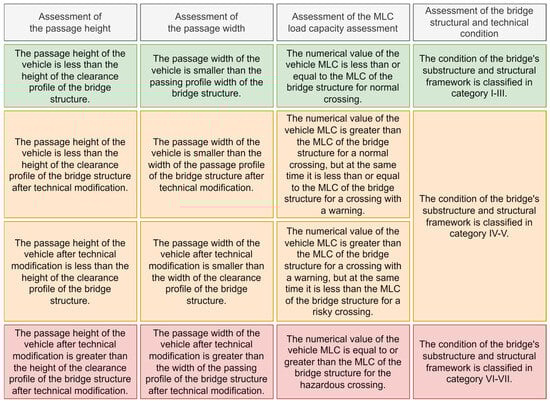
Figure 9.
Categorisation of the suitability of infrastructure objects for the selected type of transport.
Following this process, it is possible to validate the current state of the defined critical infrastructure objects, which creates the basis for defining construction-technical requirements.
3.3. Digitalization of Critical Infrastructure Objects of the TEN-T Land Infrastructure
An important supporting tool for identifying critical objects of the TEN-T land infrastructure is their digitalization. Digitalization allows for the precise identification of problematic points in the transport network, where there may be limitations due to the load-bearing capacity of bridges or the clearance height of underpasses and tunnels. Using the Road Databank [50] and outputs from the above presented procedure, it is possible to create detailed map documents that categorize the infrastructure according to its passability for all excessive or oversized transports.
The digitalization of critical TEN-T land infrastructure objects also plays a key role in the planning of strategic military transport. The analysis within this process focuses on the ability of bridges, tunnels, and underpasses to meet the requirements of military transport, which is essential for crisis scenarios and ensuring the smooth passage of excessive or oversized transports. The digitalization includes the evaluation of the load-bearing capacity of bridges and the clear heights of underpasses and tunnels in order to determine their passability. Bridges were divided into four transport modes: normal, warning, risk and exceptional load exceeded. Two modes were defined for tunnels and underpasses—pass and warning. Thanks to this categorisation, it was possible to create a clear model of the transport network, which provides key information for planning military movements and allows for the effective identification of critical sections that require reconstruction or other measures. An example of the digitalization of the results of the assessment of the suitability of Exit 10 of the D0 motorway (outer Prague ring road) for selected vehicles/trains is demonstrated in Figure 10.
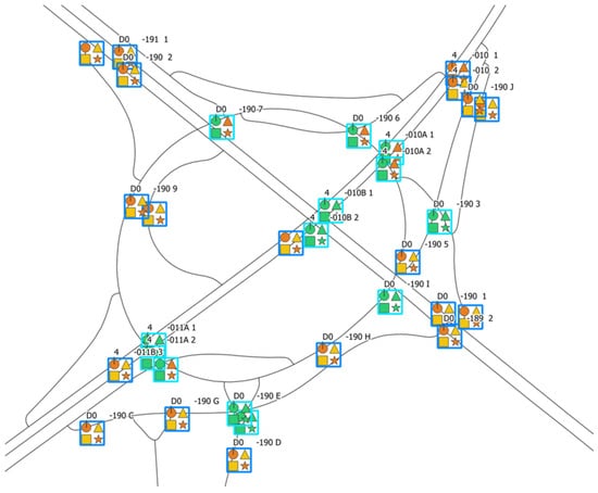
Figure 10.
Results digitization example of the infrastructure objects suitability assessment for a selected type of transport.
Figure 10 was created using QGIS (v3.38), an open-source geographic information system. The process of creating the map output included two key steps. The first step was the digitization of critical land infrastructure objects, which was carried out based on detailed map data from the Roads and Highways Directorate [50], GIS layers of the road network, and the proposed Procedure for identifying critical infrastructure objects of the TEN-T land infrastructure (see Section 3.2). Using these inputs, key infrastructure objects were identified—bridges, underpasses, and tunnels, which were subsequently categorized according to their passability for typical military transport.
The second step was data processing in QGIS, where individual critical objects were imported into the software environment and assigned the corresponding attributes. Each bridge, tunnel, and underpass were classified based on their condition and impact on military transport, or possible restrictions for military equipment crossings. Subsequently, a visualization was created in QGIS, which included setting the symbology and exporting the map output as a raster image. The export was performed at high resolution so that all labels and legends were readable.
The colour and shape differentiation of infrastructure objects allows for quick recognition of restrictions and effective interpretation of results. Tunnels are marked on the map as a square with a pink outline, with green indicating full traffic and orange indicating the need for special measures. Underpasses are shown as squares with a blue outline, and their trafficability is indicated by the same colour code. Bridges are shown as squares with a dark blue outline, where green indicates full trafficability, orange and yellow warn of restrictions (yellow—warning, orange—risk), and red indicates that the object is not passable for military transport without accurate calculation. Individual symbols then indicate the following types of transport: Circle—Leopard tank, Triangle—Wheel loader, Square—Fire truck, and Star—Rescue vehicle.
The results of the digitalization confirm that there are fundamental limitations for heavy military equipment on some sections, either due to the load capacity of bridges or due to insufficient clearance of underpasses and tunnels. The identified problem areas represent a potential risk for effective military mobility, which requires the implementation of specific measures. Firstly, it is necessary to focus on the modernisation of bridges, which will increase their load capacity on strategic routes. The increased load capacity will allow for the safe passage of heavy military equipment, thereby minimizing the risk of the need to reload or slow down the convoy. Modernization should be focused primarily on bridges that showed a high proportion of cases in the alert and risk mode in the analyses.
In the case of underpasses and tunnels, the possibilities for modification are considerably limited. In the case of tunnels, any height modification is practically impossible, even in new construction, because it would lead to disproportionate investments. In the case of underpasses, the situation is somewhat more flexible, but here too the possibilities for reconstruction are limited and are more feasible in newly built roads. Given these limitations, it is necessary to focus on the means of transport themselves and their adaptation to the existing infrastructure. Alternative solutions may be modular transport systems that allow for a reduction in the height of the transported units, or greater use of rail transport where the road network does not allow for trouble-free passage. An important measure is also the introduction of monitoring and predictive systems that will enable regular monitoring of the condition of critical objects and timely planning of their modernisation. As part of the further development of digitalization, it is appropriate to regularly update digital maps to reflect changes in the infrastructure and enable effective planning of military mobility. The knowledge gained will also be used in the preparation of strategic plans and crisis scenarios, which will ensure better preparedness of transport infrastructure for both military and civilian purposes.
3.4. Defining Recommendations for the Sustainability and Future Development of TEN-T Land Infrastructure in the Context of Military Mobility
The need for a systematic definition of recommendations for future development arises from the identified gaps, especially in connection with military mobility. Military mobility in this context can be understood as the military movement and transport from places of permanent deployment (supply hubs) to the final destination (logistics base or generally to the Area of Responsibility). As part of this process, it is necessary to plan the routes and times of military convoy movements, including ROM/RON. However, there are also fundamental construction-technical and capacity aspects (constraints) in the background of this process, which are also affected by external entities. The analyses carried out show the need for systematic development of the TEN-T in four basic layers (see Figure 11).
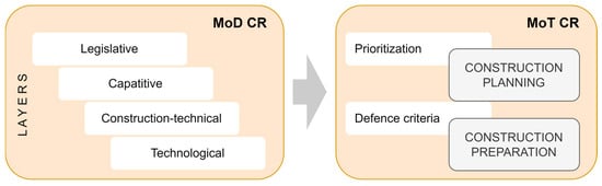
Figure 11.
Recommendations for the sustainability and future development of TEN-T land infrastructure.
3.4.1. Legislative Layer: Amend the Relevant Legislation with the Possibility of Prioritizing Military Movements
Ensuring military mobility within the Czech Republic primarily has a legislative and legal dimension. A fundamental shortcoming at present is that in the event of the implementation of the worst-case scenarios that would lead to the above-standard use of TEN-T, military movements have only minimal legislative and legal support. With the exception of the new definition of a military train, which partially interferes with the prioritization of passenger transport on the railway, the key problem remains, which is the impossibility of fundamentally interfering with civilian traffic. Within the framework of the road movement, which will form the backbone of the military movement, it is only possible to ensure the temporary removal of closures or the suspension of repairs and maintenance (through agreements with the Ministry of Transport of the Czech Republic, the Road and Motorway Directorate, etc.) and to ensure management through the Military Police, or the Police of the Czech Republic. From a legislative perspective, the key problem is the time discrepancy between the requirement for military mobility and the declaration of the relevant state of crisis, when the powers of public administration entities change.
3.4.2. Capacitive Layer: FOCUS on the Specifics of Military Mobility and Conduct Relevant Military Movements Simulations
Military mobility can be understood as military movement/transportation from places of permanent deployment to the target destination. As part of this process, it is necessary to plan the routes and times of military convoy movements, including rest areas ROM/RON. The aim is to coordinate activities with regard to the capacity possibilities of the TEN-T. However, there are also construction and technical aspects (constraints) behind this process, which are also entered into by external entities. Within the Czech Republic, this is primarily the Ministry of Transport and infrastructure operators (i.e., Road and Motorway Directorate and Railway Infrastructure Administration). The entire process of moving military units of NATO member states’ armies is implemented with the support of the Czech Republic (Host Nation Support). HNS is primarily intended to ensure a smooth and coordinated passage through the Czech Republic, including ensuring the necessary logistics (creating ROM/RON, refuelling, providing evacuation capacities in the event of a technical problem, etc.).
Partial capacity deficiencies are a prerequisite—especially in the worst-case scenario, which is classified (NATO Secret) and cannot be specified. In this scenario, a large number of military units will be moved from west to east across the territory of the Czech Republic. The assumption is to maintain the standard regime, i.e., a military unit, max. 48 h on our territory, incl. rest, and other necessary activities (e.g., repairs). The goal should be, in extreme situations and only temporarily, the possibility of a fundamental restriction or stoppage of civilian traffic (with the exception of the components of the Integrated Rescue System). The measure also includes the possibility of using Intelligent Transport Systems and new technologies to better manage traffic flow, especially in narrow places (i.e., connections to expressways, bridges, roundabouts, etc.), where there are dimensional or weight limits [61].
However, this depends on the ratio between the real throughput—the capacity of transport routes (TEN-T) and the number of vehicles. For these purposes, the Ministry of Defence of the Czech Republic should have at its disposal capacity simulations of selected convoys (scenarios) to ensure the smooth implementation of military movements and transports, including the resulting requirements for HNS. Simulations of selected scenarios will also allow for the detection of other expected gaps within the comprehensive provision of HNS for military movements and transports.
3.4.3. Construction-Technical Layer: Prioritize Relevant Infrastructure Objects (Primarily Bridges) in the Maintenance and Repair System in Cooperation with the Ministry of Defence of the Czech Republic/Ministry of Defence of the Czech Republic
The construction and technical aspect are very time-consuming and also require the aspect of sustainability and dynamics. Sustainability in the sense of ensuring the passage of not only the first convoy but all convoys of vehicles so that the key infrastructure elements are always in an appropriate (at least sufficient) technical condition. For example, in the case of bridges, ensuring an appropriate technical condition is a big question mark, mainly due to the above-standard use of the TEN-T, i.e., also of these specific infrastructure elements. To illustrate, the above-mentioned scenario may be a situation where from the point of view of excessive transport (higher load—total/axle load than usual), the relevant bridges will be loaded in one week of military movements more than in 1–2 “normal” years. The impact on the technical condition of bridges must, therefore, be assessed dynamically, i.e., simulate this above-standard use, moreover, in such a short period of time. This is not yet available, and it can only be assumed that during the first week of military deployment, some bridges will move from the “green” category (unrestricted use), when the bridge is in perfect (I.), very good (II.), or at least good (III.) condition, to the “yellow” category (restricted use), when the bridge is in a satisfactory (IV.) or poor (V.) condition.
The construction and technical level are in the system of maintenance, repair and modernization of the relevant bridges in the given concept. If the process is not planned with appropriate prioritization and financial resources, the condition of the given bridges may already be in the yellow category or even in the red category at the moment of the start of the implementation of the relevant scenario. For example, on the backbone road—the D1 motorway—two motorway bridges were even in the red category (in very poor condition) in 2024 and several dozen in the yellow category. The evidence for this classification can be found in bridge inspection reports in the Bridge Management System database [62].
3.4.4. Technological Layer: Use the Tools of Intelligent Transport Systems and New Technologies
Intelligent Transport Systems (ITSs) play a crucial role in the modernisation and efficient management of transport infrastructure within the TEN-T, particularly on motorways, main railway corridors and multimodal transport hubs. The integration of ITS into the TEN-T transport infrastructure ensures higher efficiency of the transport system, minimizes delays, and contributes to the achievement of the objectives of sustainable mobility and emission reduction in line with the European Transport Strategy.
The Action Plan of the Ministry of Transport of the Czech Republic for the Development of ITSs sets out strategic objectives and measures for their implementation and modernisation in the Czech Republic [63]. These objectives are based on a detailed analysis of the shortcomings of existing ITS solutions, the priorities of the Czech Republic’s transport policy, related strategic documents, and legislative requirements. The plan focuses on the systematic introduction and development of ITSs across all modes of transport with an emphasis on their interconnection, interoperability, and efficient use of the existing transport infrastructure. The action plan includes a specification of specific measures, estimated financial costs for their implementation, and identification of possible sources of financing with the aim of maximizing the benefits of ITSs for the transport system and safety and sustainable mobility. The ITS implementation plan is designed as a living document with continuous updates.
ITSs are of key importance for security and rescue services, especially for the Integrated Rescue System and the Army of the Czech Republic. Connecting ITSs with security and crisis systems enables a faster and more effective response to emergencies, which leads to higher protection of the population and a reduction in the risks associated with traffic accidents or disasters. The main recommendations in the field of ITSs are:
- Strengthen the ability of ITS and professional personnel to respond to new threats, emergencies, and cooperate with the Army of the Czech Republic (e.g., movements of own and allied forces—HNS).
- Supplement ITSs according to the requirements and needs of the Army of the Czech Republic, e.g., supplement the collection of data on the condition and operation of land roads with the detection of new emergencies and transfer and sharing of these data. Use the potential of unmanned vehicles.
- Strengthen the infrastructure and build elements of active traffic management on selected sections of land roads so that it is possible to effectively manage traffic flows of civilian and military vehicles.
- Involve fleets of land road administrator vehicles/assistance service vehicles equipped with ITS and other technologies in resolving emergencies that are beyond their basic purpose.
- Increase the resilience of ITSs, existing and newly built, against cyber-attacks.
- Make static and dynamic data and information accessible and share, e.g., on the condition and operation of roadways, between civilian ITSs (including the Integrated Rescue System) and the systems of the Army of the Czech Republic. Protect sensitive data, e.g., exchange and purpose of data, data transfer, etc.
3.4.5. Summary of Recommendations
The development of transport infrastructure, especially TEN-T, is not only a key condition for the implementation of military movements and military transports of the Army of the Czech Republic but also of the armies of NATO member states. The analyses carried out show that there are relatively significant gaps within the defined layers. The priority task in this area is to resolve the issue throughout the European Union in coordination with planning at the NATO level. Nation states and the Czech Republic are no exception; they derive individual measures and their prioritization from these superior plans. The capacity shift in the context of the new NATO model, which responded to the Russian–Ukrainian conflict, means a several-fold higher burden on the transport infrastructure (and related requirements for HNS). The above requires much greater communication between interested entities (MoD CR, MoT CR, and infrastructure operators, i.e., the Road and Motorway Directorate and Railway Infrastructure Administration), including appropriate methodological documents. The methodology from the level of the Ministry of Transport of the Czech Republic is the authorship collective of the article in the certification process, as well as the Methodological Guidelines from the level of the Ministry of Defence of the Czech Republic. Both documents should clearly elaborate on the areas mentioned in the article, including the setting of communication, cooperation, and coordination between the two ministries. The first is the setting of a process model for determining the prioritization of transport structures on the TEN-T by including a new “military” criterion, which would be set by the responsible body of the Ministry of Defence of the Czech Republic (usually the military transport authorities). In the case of road structures on the TEN-T, the priorities of the Ministry of Defence of the Czech Republic can be included by excluding a specific transport structure from the process of economic evaluation of the structure by the Central Commission of the Ministry of Transport of the Czech Republic, in a similar way to the procedure for removing critical points on sections of class I roads from the point of view of removing critical points in the field of road safety.
However, the economic aspect must also be considered and the process model should be set between the Ministry of Defence of the Czech Republic and the Ministry of Transport of the Czech Republic so that specific construction and technical parameters of the structures are already defined in the preparation phase of transport structures on the TEN-T and are part of the implementation of the technical study, or documentation for a joint permit. Additional inputs and requirements in a higher stage of project development increase the cost of the actual construction and extend the project implementation period.
At the national level, it is also necessary to revise the so-called Designated Road and Railway Network, i.e., transport routes important for military mobility and, in a broader context, for the defence of the state. The revision should include bottlenecks (primarily bridges), which are already in the red/yellow category. The mentioned bottlenecks should be included as a priority in the repair/modernization plan, while adhering to the required construction and technical parameters. In cooperation with the Ministry of Transport of the Czech Republic and the Directorate of Roads and Highways, rest areas intended for the establishment of ROM/RON should be further separately addressed.
4. Conclusions
The essence of the article is to define recommendations for the sustainability and future development of the TEN-T land infrastructure to address large-scale disasters. For this purpose, a description of the TEN-T land infrastructure in the Czech Republic was first carried out, a description of large-scale disasters resulting in above-standard use of the TEN-T land infrastructure was described, and the methods used for modelling and digitizing routes for excessive and oversized transport were described.
Based on these facts, typical transport situations using the TEN-T land infrastructure were defined and modelled. Subsequently, attention was paid to the identification and digitization of critical infrastructure objects of the TEN-T land infrastructure. In this part of the article, an identification procedure consisting of three phases was proposed, namely (1) selection of the type of transport and identification of the technical parameters of the convoy, (2) identification of construction-technical parameters of the affected infrastructure objects, and (3) assessment of the infrastructure objects suitability for the selected type of transport.
The core part of the article was the definition of recommendations for the sustainability and future development of the TEN-T land infrastructure to address large-scale disasters. These recommendations were classified into five layers, which represent the requirements of the Ministry of Defence of the Czech Republic towards the Ministry of Transport of the Czech Republic. These layers consider the requirements in the areas of legislative, capacitive, construction-technical, economic-procedural, and intelligent transport systems.
The results presented in this article are primarily intended for competent employees of the Ministry of Defence of the Czech Republic and the Ministry of Transport of the Czech Republic, who are responsible for the implementation of excessive and oversized transport. However, they can also be used by lower-level entities, specifically the Road and Motorway Directorate and Railway Infrastructure Administration, in order to define specific construction-technical requirements for the TEN-T land infrastructure.
The current research included several limitations due to its large scale. Of the large number of large-scale disasters, primary attention was paid only to armed conflict, which requires extensive and above-standard use of the TEN-T land infrastructure. The research was further limited to a specific type of infrastructure object, namely bridge structures. The last and most significant limitation was the aspect of the perception of the sustainability of the transport infrastructure, which was examined only in the context of construction-technical parameters.
In conclusion, it is appropriate to state that in the current turbulent security situation, construction-technical requirements for infrastructure objects on the TEN-T need to be given due attention. Since the dual use of the transport infrastructure is assumed, follow-up research must include a comprehensive examination of the necessary level of reliability of the affected infrastructure objects when dealing with all types of crisis situations and all possible scenarios of use. It should also be emphasized that any shift in construction-technical requirements usually has a significant impact on the construction technologies used and subsequent sustainability and, thus, on the overall economy.
Author Contributions
Conceptualization, D.R. and P.M.; methodology, D.R., M.V., P.M., J.A., T.A., and M.H.; validation, P.M., M.V., and J.A.; formal analysis, D.R., M.V., P.M., and J.A.; investigation, T.A. and M.H.; resources, D.R., M.V., and P.M.; data curation, T.A. and M.H.; writing—original draft preparation, D.R., M.V., P.M., J.A., T.A., and M.H.; writing—review and editing, D.R., M.V., P.M., J.A., T.A., and M.H.; visualization, D.R.; supervision, D.R.; project administration, D.R.; funding acquisition, D.R. All authors have read and agreed to the published version of the manuscript.
Funding
This research was funded by the Technology Agency of the Czech Republic, grant number CK03000182.
Institutional Review Board Statement
Not applicable.
Informed Consent Statement
Not applicable.
Data Availability Statement
All data and information are available in this article.
Conflicts of Interest
The authors declare no conflicts of interest. The funders had no role in the design of the study; in the collection, analyses, or interpretation of data; in the writing of the manuscript; or in the decision to publish the results.
Abbreviations
The following abbreviations are used in this manuscript:
| EU | European Union |
| HNS | Host Nation Support |
| ITS | Intelligent Transportation System |
| MoD CR | Ministry of Defence of the Czech Republic |
| MLC | Military Load Classification |
| MoT CR | Ministry of Transport of the Czech Republic |
| NATO | North Atlantic Treaty Organization |
| ROM | Rest on Movement |
| RON | Rest on Night |
| TEN-T | Trans-European Transport Networks |
References
- Directive (EU) 2022/2557 of the European Parliament and of the Council of 14 December 2022 on the Resilience of Critical Entities and Repealing Council Directive 2008/114/EC. Available online: http://data.europa.eu/eli/dir/2022/2557/oj (accessed on 10 March 2025).
- Regulation (EU) 2024/1679 of the European Parliament and of the Council of 13 June 2024 on Union Guidelines for the Development of the Trans-European Transport Network, Amending Regulations (EU) 2021/1153 and (EU) No 913/2010 and repealing Regulation (EU) No 1315/2013. Available online: http://data.europa.eu/eli/reg/2024/1679/oj (accessed on 10 March 2025).
- European External Action Service. A Strategic Compass for Security and Defence; European Union: Brussels, Belgium, 2022; Available online: https://www.eeas.europa.eu/eeas/strategic-compass-security-and-defence-1_en (accessed on 29 November 2024).
- Sendai Framework for Disaster Risk Reduction 2015–2030; United Nations Office for Disaster Risk Reduction: Geneva, Switzerland, 2015.
- Banholzer, S.; Kossin, J.; Donner, S. The Impact of Climate Change on Natural Disasters. In Reducing Disaster: Early Warning Systems for Climate Change; Singh, A., Zommers, Z., Eds.; Springer: Dordrecht, The Netherlands, 2014; pp. 21–49. [Google Scholar] [CrossRef]
- Shi, P. Disaster Risk Management. In Disaster Risk Science; Springer: Singapore, 2019; pp. 491–539. [Google Scholar] [CrossRef]
- Bernatik, A.; Senovsky, P.; Senovsky, M.; Rehak, D. Territorial Risk Analysis and Mapping. Chem. Eng. Trans. 2013, 31, 79–84. [Google Scholar] [CrossRef]
- Vichova, K.; Hromada, M.; Rehak, D. The Use of Crisis Management Information Systems in Rescue Operations of Fire and rescue system in the Czech Republic. Procedia Eng. 2017, 192, 947–952. [Google Scholar] [CrossRef]
- Gad-el-Hak, M. Large-Scale Disasters: Prediction, Control, and Mitigation; Cambridge University Press: Cambridge, UK, 2008. [Google Scholar] [CrossRef]
- Jiang, Y.; Yuan, Y. Emergency Logistics in a Large-Scale Disaster Context: Achievements and Challenges. Int. J. Environ. Res. Public Health 2019, 16, 779. [Google Scholar] [CrossRef] [PubMed]
- Directorate-General for Mobility and Transport. Trans-European Transport Network (TEN-T); European Commission: Brussels, Belgium, 2024. [Google Scholar]
- Macioszek, E. Oversize cargo transport in road transport—Problems and issues. Sci. J. Silesian Univ. Technol. Ser. Transp. 2020, 108, 133–140. [Google Scholar] [CrossRef]
- United Nations. Sustainable Transport; Department of Economic and Social Affairs: New York, NY, USA, 2015; Available online: https://sdgs.un.org/topics/sustainable-transport (accessed on 4 March 2025).
- Angelov, S.; Jimenez, C.K.; Wall, V.; O’Croínin, D. An assessment of sustainable transport infrastructure in a national healthcare system. Surgeon 2024, 22, 203–208. [Google Scholar] [CrossRef]
- Bénichou, W. Sustainable development of transport infrastructure in the system of national economy. J. Econ. Innov. Manag. Entrep. 2024, 1. [Google Scholar] [CrossRef]
- Sobczuk, S.; Borucka, A. Recent Advances for the Development of Sustainable Transport and Their Importance in Case of Global Crises: A Literature Review. Appl. Sci. 2024, 14, 10653. [Google Scholar] [CrossRef]
- Bland, M.; Burke, M.I.; Bertolaccini, K. Taking steps toward healthy & sustainable transport investment: A systematic review of economic evaluations in the academic literature on large-scale active transport infrastructure. Int. J. Sustain. Transp. 2024, 18, 201–220. [Google Scholar] [CrossRef]
- Zhang, Y.; Cheng, L. The role of transport infrastructure in economic growth: Empirical evidence in the UK. Transp. Policy 2023, 133, 223–233. [Google Scholar] [CrossRef]
- Badassa, B.B.; Sun, B.; Qiao, L. Sustainable Transport Infrastructure and Economic Returns: A Bibliometric and Visualization Analysis. Sustainability 2020, 12, 2033. [Google Scholar] [CrossRef]
- Fokina, O.; Mottaeva, A.; Mottaeva, A. Transport infrastructure in the system of environmental projects for sustainable development of the region. In Proceedings of the International Scientific Conference Transport Technologies in the 21st Century (TT21C-2024), Rostov-on-Don, Russia, 8–10 April 2024; Curran Associates, Inc.: Sydney, Australia, 2024; Volume 515, p. 01015. [Google Scholar] [CrossRef]
- Fang, W.; Ma, C.; Lei, Z. Research on Sustainable Development of Transport Infrastructure Based on Corporate Culture and Low-Carbon Perspective. J. Environ. Public Health 2022, 1, 4629422. [Google Scholar] [CrossRef] [PubMed]
- Ghent, C. Mitigating the Effects of Transport Infrastructure Development on Ecosystems. Consilience: J. Sustain. Dev. 2018, 18, 58–68. [Google Scholar] [CrossRef]
- Bao, L.; Kusadokoro, M.; Chitose, A.; Chen, C. Development of socially sustainable transport research: A bibliometric and visualization analysis. Travel Behav. Soc. 2023, 30, 60–73. [Google Scholar] [CrossRef]
- Winata, D.T.; Rarasati, A.D. Sustainable infrastructure transportation to improve society wellbeing in Karawang. In Proceedings of the 2nd International Tropical Renewable Energy Conference (i-TREC), Bali, Indonesia, 3–4 October 2017; IOP Publishing Ltd.: Bristol, UK, 2018; Volume 105, p. 012008. [Google Scholar] [CrossRef]
- Oberg, M.; Nilsson, K.L.; Johansson, C. Major transport corridors: The concept of sustainability in EU documents. Transp. Res. Procedia 2017, 25, 3694–3702. [Google Scholar] [CrossRef]
- Petru, J.; Krivda, V. The Transport of Oversized Cargoes from the Perspective of Sustainable Transport Infrastructure in Cities. Sustainability 2021, 13, 5524. [Google Scholar] [CrossRef]
- Milani, L.; Mohr, D.; Sandri, N. Built to Last: Making Sustainability a Priority in Transport Infrastructure; McKinsey & Company: New York, NY, USA, 2021; Available online: https://www.mckinsey.com/industries/infrastructure/our-insights/built-to-last-making-sustainability-a-priority-in-transport-infrastructure (accessed on 4 March 2025).
- Mead, L. The Road to Sustainable Transport; International Institute for Sustainable Development: Winnipeg, MB, Canada, 2021; Available online: https://www.iisd.org/articles/deep-dive/road-sustainable-transport (accessed on 4 March 2025).
- Treaty on European Union (92/C 191/01). Available online: https://eur-lex.europa.eu/legal-content/EN/TXT/?uri=oj:JOC_1992_191_R_TOC (accessed on 10 March 2025).
- Bottcher, B. The Trans-European Transport Network (Ten-T): History, Progress and Financing. Commun.-Sci. Lett. Univ. Zilina 2006, 8, 51–54. [Google Scholar] [CrossRef]
- Regulation (EU) No 1315/2013 of the European Parliament and of the Council of 11 December 2013 on Union Guidelines for the Development of the Trans-European Transport Network and Repealing Decision No 661/2010/EU. Available online: http://data.europa.eu/eli/reg/2013/1315/oj (accessed on 10 March 2025).
- Rehak, D.; Senovsky, P.; Hromada, M.; Lovecek, T. Complex Approach to Assessing Resilience of Critical Infrastructure Elements. Int. J. Crit. Infrastruct. Prot. 2019, 25, 125–138. [Google Scholar] [CrossRef]
- Fekete, A. Common Criteria for the Assessment of Critical Infrastructures; Federal Office of Civil Protection and Disaster Assistance: Bonn, Germany, 2011. [Google Scholar]
- Czech, M. PAN—European transport corridors in the policy of the European Union. Sci. J. Silesian Univ. Technol. Ser. Transp. 2021, 112, 51–62. [Google Scholar] [CrossRef]
- Hudec, S. Motorways in the Czech Republic; Czech Motorways: Prague, Czech Republic, 2024; Available online: https://www.ceskedalnice.cz/wp-content/uploads/zpoplatnene-velka.png (accessed on 3 December 2024).
- Road and Motorway Directorate. Communication Lengths and Other Data. 2024. Available online: https://web.archive.org/web/20250125192752/https://www.rsd.cz/web/guest/silnice-a-dalnice/delky-a-dalsi-data-komunikaci#zalozka-silnice-i-tridy (accessed on 3 December 2024).
- Railway Administration. High-Speed Lines: Sections and Maps. 2024. Available online: https://vrtky.cz/useky-a-mapy (accessed on 3 December 2024).
- Kryze, P. Railway Transit Corridors; Railway Administration: Prague, Czech Republic, 2024; Available online: https://www.spravazeleznic.cz/documents/50007830/51605747/tranzitn%C3%AD+koridory.pdf/d09016c4-89b8-4815-b9d9-bd68bdf28d94 (accessed on 3 December 2024).
- K-Report. Railway Corridors of the Czech Republic: Characteristics of Corridors. 2024. Available online: https://www.k-report.net/koridory/histori3.htm (accessed on 3 December 2024).
- Kelman, I. Addressing the root causes of large-scale disasters. In Large-Scale Disasters: Prediction, Control, and Mitigation; Gad-el-Hak, M., Ed.; Cambridge University Press: Cambridge, UK, 2009; pp. 94–119. [Google Scholar] [CrossRef]
- Gad-el-Hak, M. (Ed.) The art and science of large-scale disasters. In Large-Scale Disasters: Prediction, Control, and Mitigation; Cambridge University Press: Cambridge, UK, 2009; pp. 5–68. [Google Scholar] [CrossRef]
- Baxter, P.J. Catastrophes—Natural and Man-Made Disasters. In Conflict and Catastrophe Medicine; Ryan, J., Mahoney, P.F., Greaves, I., Bowyer, G., Eds.; Springer: London, UK, 2002; pp. 27–48. [Google Scholar] [CrossRef]
- IRDR. Peril Classification and Hazard Glossary (IRDR DATA Publication No. 1); Integrated Research on Disaster Risk: Beijing, China, 2014. [Google Scholar]
- Stallings, R.A. Man-made Disasters. Int. J. Mass Emergencies Disasters 1998, 16, 225. [Google Scholar] [CrossRef]
- Council Directive 96/53/EC of 25 July 1996 Laying Down for Certain Road Vehicles Circulating Within the Community the Maximum Authorized Dimensions in National and International Traffic and the Maximum Authorized Weights in International Traffic. Available online: http://data.europa.eu/eli/dir/1996/53/oj (accessed on 10 March 2025).
- Paulus, F.; Kromer, A.; Petr, J.; Cerny, J. Hazard Analysis for the Czech Republic; Fire Rescue Service of the Czech Republic: Prague, Czech Republic, 2015. [Google Scholar]
- EM-DAT. Disaster Classification System. 2023. Available online: https://doc.emdat.be/docs/data-structure-and-content/disaster-classification-system/#fn:5 (accessed on 10 December 2024).
- Ministry of Defence. Czech Armed Forces Development Concept 2035; The Ministry of Defence of the Czech Republic: Prague, Czech Republic, 2024. [Google Scholar]
- NATO. Road Movements and Movement Control (AMovP-1); Nort Atlantic Treaty Organization: Brussels, Belgium, 2004. [Google Scholar]
- Road and Motorway Directorate. Road databank and National Traffic Information Centre; Road and Motorway Directorate: Prague, Czech Republic, 2025; Available online: https://web.archive.org/web/20230203134022/https://www.rsd.cz/rsd/silnicni-databanka-a-ndic (accessed on 12 January 2025).
- NATO. Military Load Classification of Bridges, Ferries, Rafts and Vehicles (STANAG 2021), 8th ed.; North Atlantic Treaty Organization: Brussels, Belgium, 2017. [Google Scholar]
- NATO. Military Load Classification of Bridges, Ferries, Rafts and Vehicles (AEP-3.12.1.5), Edition A, Version 1; North Atlantic Treaty Organization: Brussels, Belgium, 2017. [Google Scholar]
- Lenner, R.; Keuser, M.; Sykora, M. Safety Concept and Partial Factors for Bridge Assessment under Military Loading. Adv. Mil. Technol. 2014, 9, 5–20. [Google Scholar]
- Polach, M.; Vlkovsky, M. Resilience of the Railway Infrastructure in an Urban Agglomeration with Regard to the Transport of Specific Material. In Proceedings of the 2023 Smart City Symposium Prague (SCSP), Prague, Czech Republic, 25–26 May 2023; Ruzicka, J., Ed.; IEEE: Prague, Czech Republic, 2023. [Google Scholar] [CrossRef]
- NATO. New NATO Force Model. In NATO Summit in Madrid; North Atlantic Treaty Organization: Madrid, Spain, 2022. [Google Scholar]
- Jagelcak, J.; Vrabel, J.; Kikrotva, M. Using of Different Road Vehicle Combinations for Abnormal Transports Based on the Assessment of Load Rating of Bridges in Slovakia for the Most Critical Vehicle Combination. In Proceedings of the 5th International Conference on Road and Rail Infrastructure, Zadar, Croatia, 17–19 May 2018; Lakusic, S., Ed.; University of Zagreb: Zagreb, Croatia, 2018. [Google Scholar] [CrossRef]
- Rehak, D.; Patrman, D.; Brabcova, V.; Dvorak, Z. Identifying Critical Elements of Road Infrastructure Using Cascading Impact Assessment. Transport 2020, 35, 300–314. [Google Scholar] [CrossRef]
- Galor, W.; Galor, A. Carriage and Securing of Oversize Cargo in Transport; Akademia Morska: Szczencin, Poland, 2011. [Google Scholar]
- Rehak, D.; Novotny, P. Bases for Modelling the Impacts of the Critical Infrastructure Failure. Chem. Eng. Trans. 2016, 53, 91–96. [Google Scholar] [CrossRef]
- Patrman, D.; Splichalova, A.; Rehak, D.; Onderkova, V. Factors Influencing the Performance of Critical Transportation Infrastructure Elements. Transp. Res. Procedia 2019, 40, 1518–1524. [Google Scholar] [CrossRef]
- Tichy, T.; Broz, J.; Ruzicka, J.; Hejciarova, E.; Belinova, Z.; Jisova, J. Information Modelling and Smart Approaches at the Interface of Road and Rail Transport. In Proceedings of the 2023 Smart City Symposium Prague (SCSP), Prague, Czech Republic, 25–26 May 2023; Institute of Electrical and Electronics Engineers: New York, NY, USA, 2023; pp. 1–8. [Google Scholar] [CrossRef]
- Brighenti, F.; Caspani, V.F.; Costa, G.; Giordano, P.F.; Limongelli, M.P.; Zonta, D. Bridge management systems: A review on current practice in a digitizing world. Eng. Struct. 2024, 321, 118971. [Google Scholar] [CrossRef]
- Ministry of Transport. Implementation Plan for the Action Plan for the Development of Intelligent Transport Systems (ITS) in the Czech Republic Until 2020 (with a View to 2050); Ministry of Transport of the Czech Republic: Prague, Czech Republic, 2016. Available online: https://md.gov.cz/Dokumenty/Strategie/ITS/Implemetacni-plan-k-Akcnimu-planu-rozvoje-intelige?returl=/Dokumenty/Strategie/ITS (accessed on 4 March 2025). (In Czech)
Disclaimer/Publisher’s Note: The statements, opinions and data contained in all publications are solely those of the individual author(s) and contributor(s) and not of MDPI and/or the editor(s). MDPI and/or the editor(s) disclaim responsibility for any injury to people or property resulting from any ideas, methods, instructions or products referred to in the content. |
© 2025 by the authors. Licensee MDPI, Basel, Switzerland. This article is an open access article distributed under the terms and conditions of the Creative Commons Attribution (CC BY) license (https://creativecommons.org/licenses/by/4.0/).