Article

Analysis of the Sustainable Development Pathway of Urban–Rural Integration from the Perspective of Spatial Planning: A Case Study of the Urban–Rural Fringe of Beijing

Kent School of Architecture and Planning, Faculty of Humanities, University of Kent, Giles Lane, Canterbury CT2 7NR, UK
Sustainability 2025, 17(5), 1857; https://doi.org/10.3390/su17051857
Submission received: 29 December 2024 / Revised: 14 February 2025 / Accepted: 17 February 2025 / Published: 21 February 2025

Abstract

:
This study employs various comprehensive research methods to thoroughly analyze the relationship between urban–rural integration and sustainable development, proposing corresponding optimization pathways. First, a literature review method systematically examines existing theories on urban–rural integration and sustainable development. Then, it identifies the main problems and challenges in the current process of urban–rural integration, thereby laying a theoretical foundation for the study. Second, a case study approach is adopted, selecting Caoqiao Village in Fengtai District, Zhenggezhuang Village in Changping District, and Xihoujie Village in Majuqiao Town, Tongzhou District of Beijing, as typical cases. These cases are analyzed in depth to explore their implementation outcomes and validate the practical results of different development pathways. Subsequently, based on specific data from Beijing’s urban–rural fringe, this study utilizes data analysis methods to conduct an in-depth examination of land use changes, ecological environment status, and influencing factors, with a focus on analyzing relevant data from 2009 to 2023. This analysis reveals the dynamic relationship between urban–rural integration and sustainable development. Regression analysis is adopted to quantify the effect of urban–rural integration on sustainable development, thus exploring the correlation between urban–rural integration, spatial planning, economic development, financial development, and sustainable development. Finally, targeted management recommendations and policy optimization plans are proposed based on the principles of ecological protection red lines and urban development boundaries. The results indicate a significant positive correlation between urban–rural integration and sustainable development levels, with a regression coefficient of 0.48, demonstrating its role in promoting sustainable development. The levels of spatial planning and economic development also positively affect sustainable development, with coefficients of 0.32 and 0.27, respectively. Moreover, financial development and social investment levels show a certain positive relationship. It is noteworthy that although the correlation between foreign trade and sustainable development levels is the lowest, the interconnections between other variables further emphasize the key position of urban–rural integration in overall sustainable development. This study offers a theoretical basis and empirical support for spatial planning in the urban–rural fringe of Beijing, ecological environment protection, and scientific policy formulation, thus advancing sustainable urban development.

1. Introduction

As the process of global urbanization accelerates, major cities are facing complex issues such as uneven resource allocation, increased ecological and environmental pressures, and unbalanced social development [1,2]. As China’s capital, Beijing has particularly experienced these challenges during its urban expansion [3,4]. There is a significant disparity in resource allocation between the urban core and the urban–rural fringe. The latter often faces problems such as outdated infrastructure and insufficient public services, leading to a relatively lower quality of life and development opportunities for residents [5,6]. Furthermore, the ecological and environmental pressures brought about by urbanization have also severely impacted the urban–rural fringe, especially in the absence of ecological protection measures, where environmental issues become more pronounced [7,8]. The lag in the development of the urban–rural fringe and the existence of an urban–rural dual structure challenge social equity [9,10]. Therefore, studying the development pathways of Beijing’s urban–rural fringe not only helps to understand these issues but also provides a vital theoretical basis and practical guidance for promoting sustainable urban development.
This study, through literature review and empirical analysis, systematically retraces the spatial planning theories and practices related to future cities and sustainable development, with a particular focus on the critical area of Beijing’s urban–rural fringe. The study analyzes the changes in land use and the current state of the ecological environment in Beijing’s urban–rural fringe, discussing the influencing factors. By selecting three typical cases (Xihoujie Village in Majuqiao Town, Tongzhou District; Zhenggezhuang Village in Changping District; and Caoqiao Village in Fengtai District), the study examines the development trajectory of urban–rural integration across different periods, revealing the dynamic changes in the urbanization process. Integrating the principles of ecological protection red lines and urban development boundaries, policy optimization plans and targeted management recommendations are presented. This study demonstrates remarkable innovation in several aspects. Initially, it closely revolves around the prominent issues faced by Beijing in the urbanization process, precisely focusing on the urban–rural fringe as a key area. It also delves into its specific challenges in the ecological environment, resource allocation, and social development, providing a unique entry point for solving common urbanization problems. Subsequently, the study employs various research methods, systematically sorting out domestic and international spatial planning theories and practices related to future cities and sustainable development through a literature review. Concurrently, a comprehensive analysis of Beijing’s urban–rural fringe is conducted with detailed data, encompassing urban size, population, economy, and specific scale of the fringe, providing a theoretical basis and solid data support for the study. Furthermore, it innovatively selects three typical cases from different periods, as mentioned earlier, for an in-depth study covering the development trajectory of urban–rural integration from the 1990s to the present. Hence, rich empirical evidence can be provided to reveal the dynamic changes in the urbanization process and sustainable development pathways. Lastly, targeted management recommendations and policy optimization plans are put forward based on the principles of urban development boundaries and ecological protection red lines. Consequently, the study explores a new pathway for the sustainable development of Beijing’s urban–rural fringe and offers an extremely valuable reference model for other similar cities. The main contribution of this study is to systematically analyze the sustainable development path of Beijing’s urban–rural fringe. It deeply explores the relationship between urban–rural integration, spatial planning, and sustainable development, proposing feasible policy optimization schemes. By selecting typical cases from different periods, the study reveals the dynamic changes and sustainable development paths during urbanization, providing new perspectives for theory and practice. In particular, by combining the theory of ecological protection red lines and urban development boundaries, the study offers targeted policy recommendations for resource allocation, ecological environment protection, and public service improvement for Beijing and other similar cities. In addition, the study innovatively combines spatial planning with sociocultural factors, emphasizing the impact of cultural differences on urban–rural integration. Thus, it provides valuable empirical evidence and reference models for future research in related fields.

2. Literature Review

The spatial planning theory of urban–rural integration and sustainable development aims to achieve coordinated development between urban and rural areas through scientific and rational spatial layout and planning methods. Thus, it can improve problems such as uneven resource allocation, ecological environment pressure, and social development imbalance. In recent years, with the acceleration of global urbanization and the popularization of sustainable development concepts, this theory has gradually become an important research direction in the urban planning field. Niu and Xu (2023) found that the balanced enhancement of living standards for these residents could be achieved by improving urban and rural infrastructure and public services. Their theory advocated promoting urban–rural integration development through industrial interaction, rational population mobility, and optimized resource allocation [11]. Xu et al. (2024) selected eight cities in the Greater Bay Area as samples, assessed their urban–rural integration trends, explored influencing factors and analyzed spatiotemporal evolution using methods such as principal component analysis. The study found that when implementing driving mechanisms, the principles of “synchronization, heterogeneity, and classification” should be strictly followed to promote high-quality development of urban–rural integration [12]. The integrated planning theory advocated for the organic combination of various plans, including land use, ecological protection, and urban and rural planning, to achieve the optimal allocation and sustainable use of spatial resources through coordinated coordination [13]. Mao et al. (2024) discovered that by implementing pilot programs for integrated planning, Zhejiang Province explored new pathways for urban–rural integration development. By coordinating urban and rural planning, land use planning, and ecological protection planning, Zhejiang Province effectively improved the efficiency of resource allocation and the coordination of urban and rural development [14]. Wei et al. (2024), based on the diversity of rural areas in Jiangsu Province, combined “top-down” and “bottom-up” evaluation perspectives to propose a “two-division, six-zone” classification scheme. Using counties as the basic unit, they divided Jiangsu’s rural areas into two major regions—the Yangtze River Delta and the Huaihai region—and further subdivided them into six functional zones. By analyzing the development patterns and directions of different rural types, the study provided references for urban–rural integration and sustainable development. It also offered a reference for rural governance in other economically developed and densely populated regions [15]. Ihle et al. (2024) argued that by implementing green plans, the Netherlands achieved significant results in polycentric development and the protection of green spaces. The plan effectively protected the natural environment on the outskirts of cities and promoted integrated urban–rural development through a rational urban layout [16]. Cuadrado-Roura (2023) proposed that the traditional urban–rural dichotomy in Europe could no longer meet the demands of contemporary urban development. This traditional binary structure struggled to effectively address the changes in resource, service, and infrastructure needs, nor could it resolve the environmental pressures and social inequalities brought about by urbanization. Consequently, the study emphasized the importance of promoting urban–rural integration and sustainable development, suggesting the need to integrate other perspectives and theories to tackle the complex challenges of urbanization and achieve more balanced and sustainable development [17]. Despite numerous achievements in the application of theories and practices, urban–rural integration and sustainable development still face several issues and challenges. Javed et al. (2024) found that resource allocation in the urban–rural fringe remained unbalanced, particularly in infrastructure and public services, where the urban–rural gap remained significant, limiting the progress of urban–rural integration development [18]. Omweri (2024) found that e-government made significant progress in urban areas, contributing to improved government transparency, reduced corruption, and optimized public services. However, in rural areas, due to weak infrastructure, low digital literacy, and limited resources, the development of e-government lagged, exacerbating the urban–rural digital divide and hindering equitable development. To promote urban–rural integration, it should strengthen digital infrastructure, expand network coverage and information services in rural areas, and implement digital literacy education to enhance rural residents’ ability to utilize e-government services [19]. Cattaneo et al. (2022) pointed out that implementing policies for urban–rural integration and sustainable development was challenging, requiring coordination among multiple departments and cross-sector collaboration. However, in practice, policy implementation faced numerous obstacles, such as conflicts of interest between departments and insufficient policy enforcement [20].
In summary, foreign scholars mainly focused on polycentric development theory, new regionalism, and eco-city theory, emphasizing the importance of regional coordination, functional complementarity, and ecological protection. Domestic research concentrated on the theories of new urbanization, rural revitalization strategies, and integrated planning committed to promoting urban–rural integration development by improving infrastructure, optimizing resource allocation, and enhancing interaction. Although previous studies have achieved certain effects in practice, they still face many challenges in terms of uneven resource allocation, ecological pressure, policy implementation difficulties, and social recognition. This necessitates further exploration of how to enhance the quality and sustainability of urban–rural integration through innovative spatial planning and management measures. This study explores the intrinsic relationship between urban–rural integration and sustainable development through an in-depth analysis of Beijing’s urban–rural fringe. It fills the existing gap in the literature regarding urban–rural integration and spatial planning. In conjunction with theoretical frameworks emphasized in both domestic and international studies, this study proposes innovative policy optimization schemes from the perspectives of ecological protection boundaries and urban development limits. Meanwhile, it offers practical management recommendations addressing issues such as unequal resource allocation and ecological environmental pressure. Through the analysis of typical case studies, this study enriches the theoretical framework of urban–rural integration and provides policymakers with actionable, implementable solutions. Therefore, it offers significant theoretical support and practical guidance for further promoting urban–rural integration and sustainable development.

3. Analysis of the Current Urban–Rural Integration and Sustainable Development Situation in Beijing

3.1. Urban–Rural Integration and Sustainable Development

Urban–rural integration refers to the process through which the boundaries between cities and rural areas gradually blur, forming close social, economic, and spatial relationships, highlighting the interdependence and cooperation between urban and rural areas [21,22]. Sustainable development means meeting current needs without compromising the ability of future generations to meet their demands; it emphasizes the balance between economic growth, social equity, and environmental protection, aiming to achieve efficient use of resources and the health of ecosystems [23,24].
There is a close relationship between urban–rural integration and sustainable development. By promoting economic, social, and spatial connections between cities and rural areas, urban–rural integration can effectively optimize resource allocation, reduce urban–rural development disparities, and enhance the overall regional economic vitality and social welfare. This integration can improve infrastructure and service levels in rural areas and promote the modernization of agriculture. Meanwhile, it can enhance sustainable urban development by balancing resource utilization with ecological protection, thus achieving environmental health and social harmony [25,26].

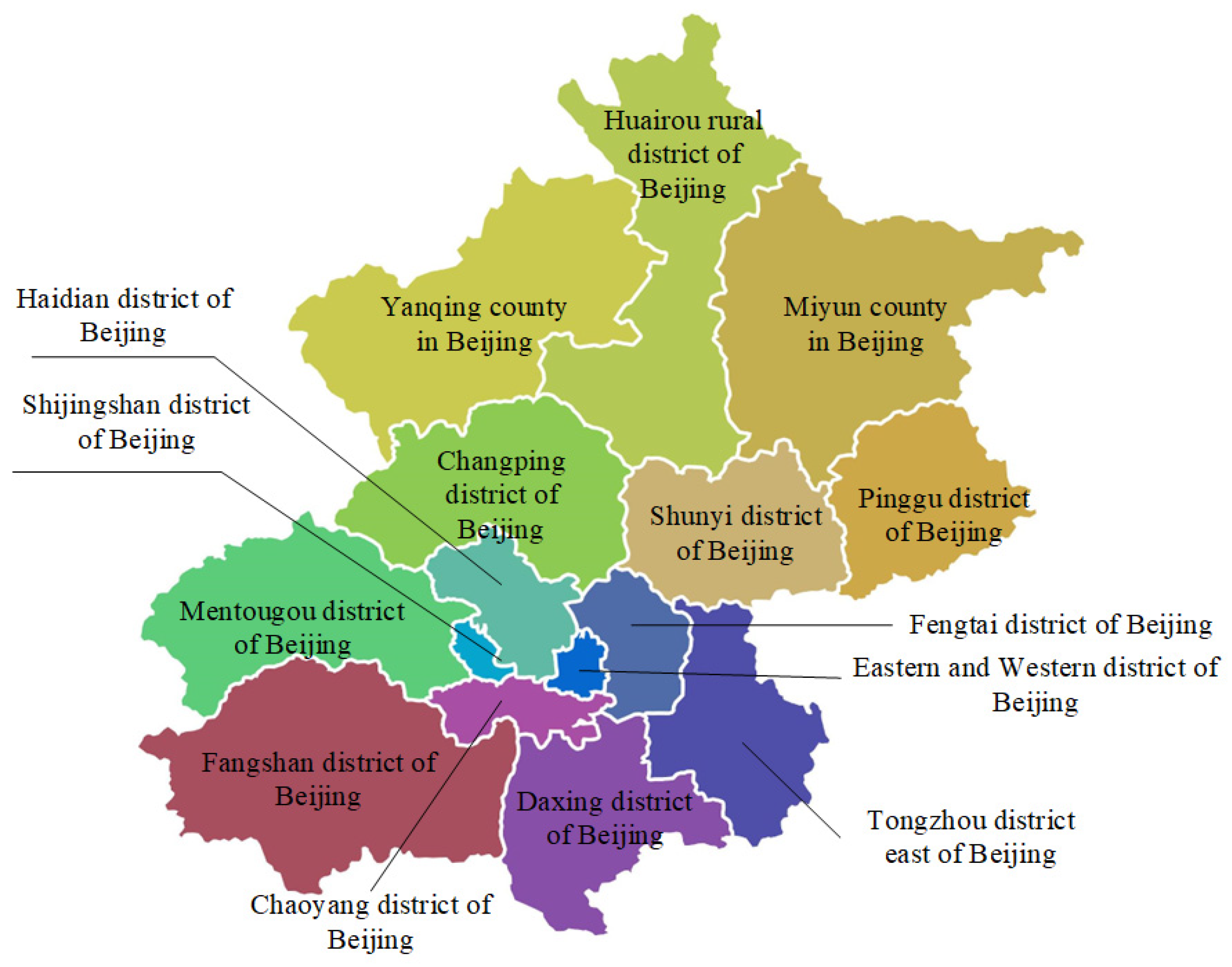
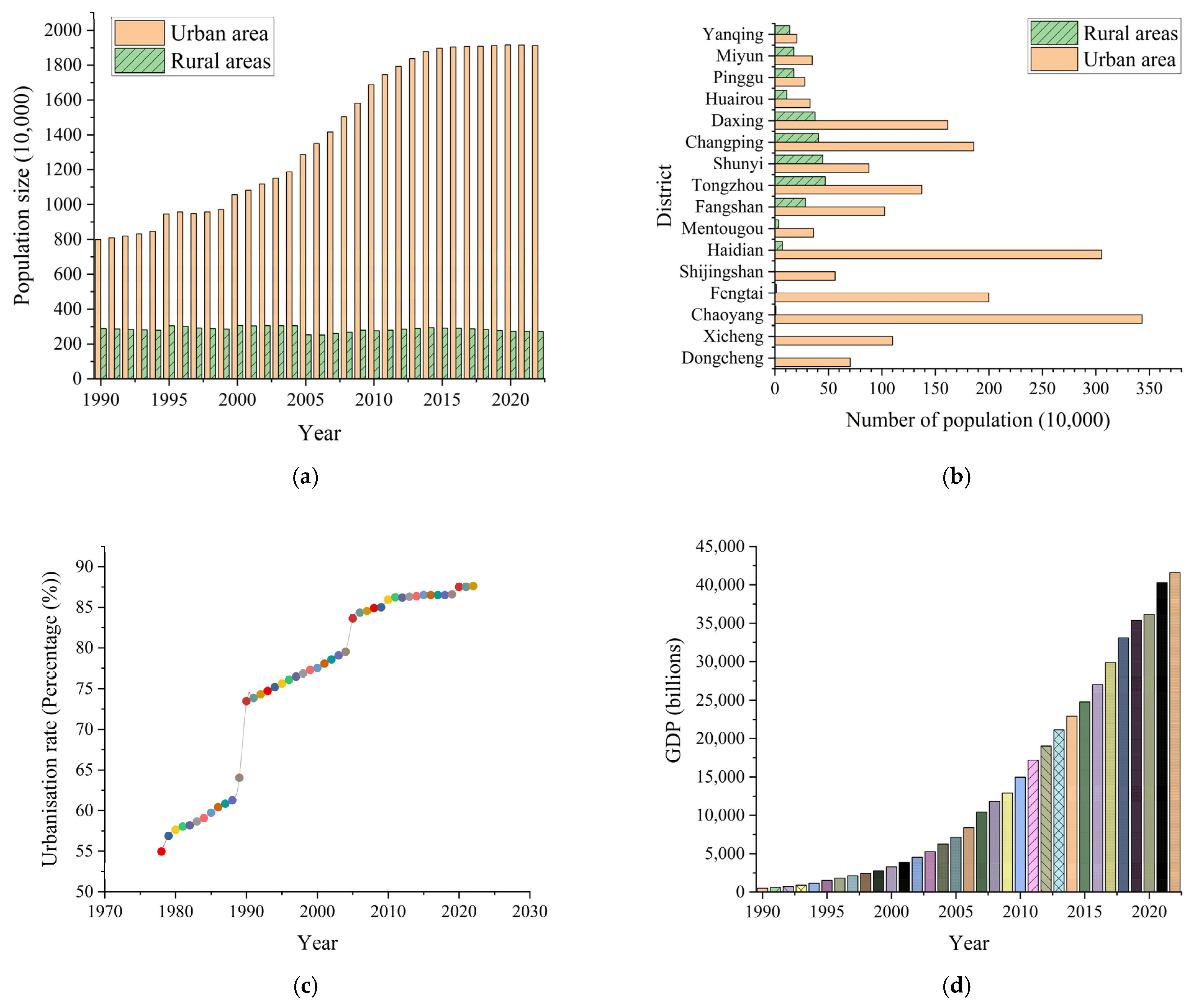
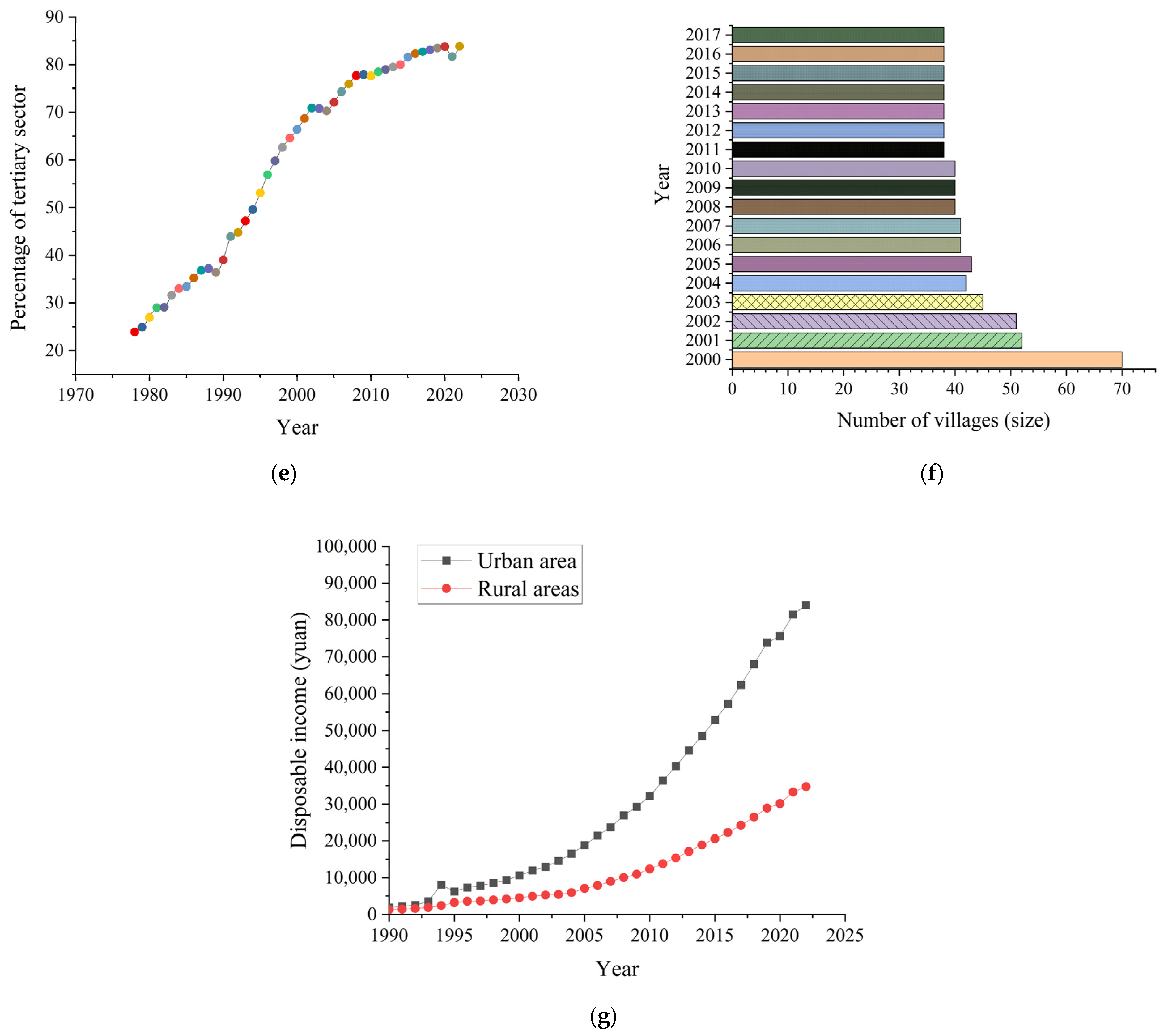
3.2. Basic Urban–Rural Integration Situation in Beijing

Over the years, Beijing has had remarkable accomplishments in economic development and technological innovation, becoming an important economic and technological center both domestically and internationally. However, Beijing also faces issues of ecological and environmental pressures, unbalanced social development, and uneven resource allocation, especially in the urban–rural fringe, where achieving sustainable development has become a crucial topic. The urban division of Beijing is presented in Figure 1.
The urban–rural fringe of Beijing refers to areas outside the concentrated construction zones planned between the Fourth and Sixth Ring Roads. It primarily encompasses the First Green and Second Green areas, with a total area of approximately 1220 square kilometers. The First Green area covers 310 square kilometers, located between the Fourth and Fifth Ring Roads, and includes six districts: Chaoyang, Haidian, Fengtai, Shijingshan, Daxing, and Changping. The Second Green area spans 910 square kilometers, situated outside the First Green area and extending 1000 m beyond the Sixth Ring Road; it includes ten districts: Chaoyang, Haidian, Fengtai, Shijingshan, Mentougou, Fangshan, Tongzhou, Shunyi, Changping, and Daxing, as well as the Economic Development Zone. The urban–rural fringe of Beijing is the area where the city meets the countryside and is a crucial node for achieving urban–rural integration development. Basic statistical information for the urban–rural fringe of Beijing is displayed in Figure 2.
As an essential component of urban development, the construction tasks in the 50 key villages of the urban–rural fringe of Beijing have been essentially completed, with an expected advancement of 20 urban villages for renovation in 2024. Currently, the urban–rural fringe of Beijing has the following characteristics. Firstly, the population is mainly concentrated in urban towns, with the level of urbanization increasing year by year, yet the urban–rural income disparity still exists. Secondly, the construction tasks in the urban–rural fringe have been essentially completed, and significant progress has been made in demolition and greening efforts; however, the urban–rural fringe still faces challenges such as insufficient coordination in environmental construction management, lack of refined management levels, and imbalanced development between urban and rural regions.

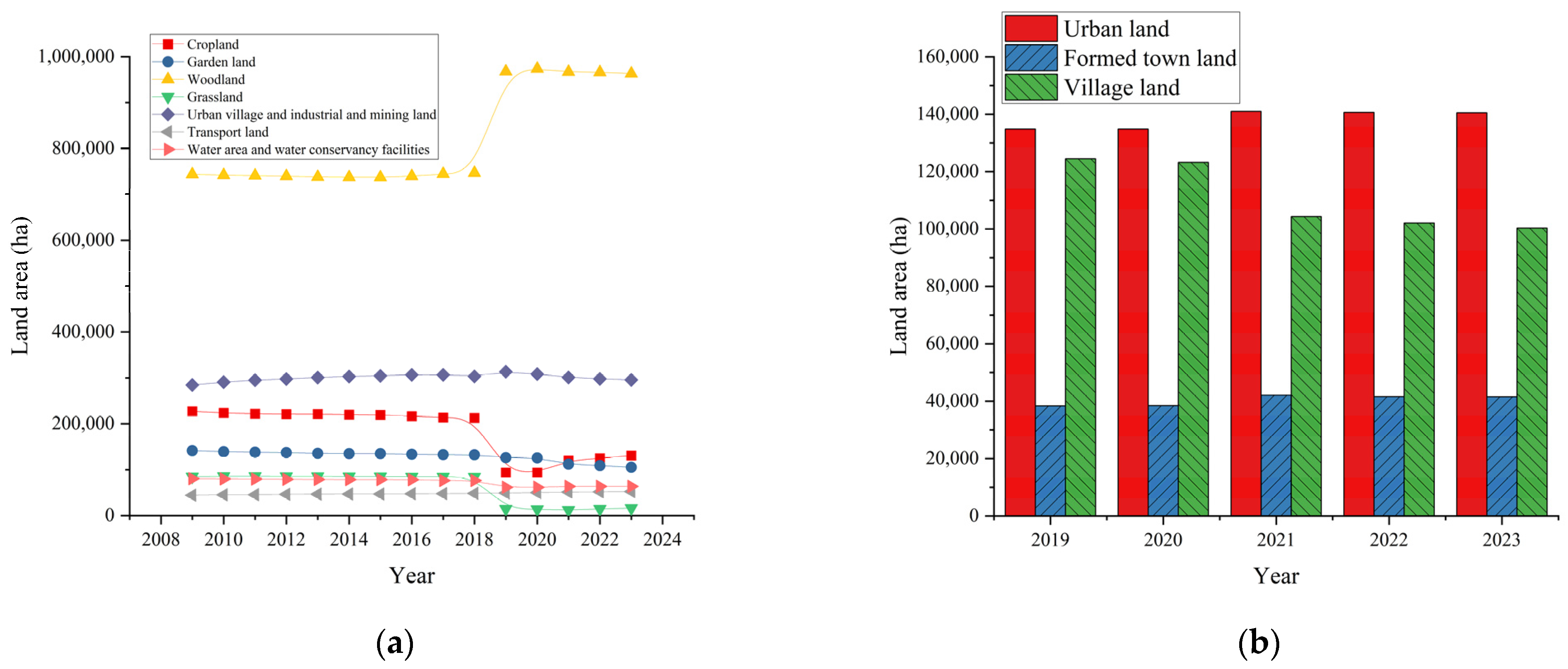
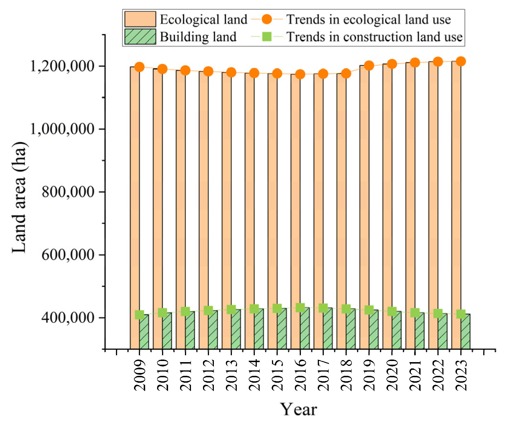
3.3. Status of Land Use Change and Ecological Environment in Beijing

Between 1999 and 2010, the construction land in the urban–rural fringe of Beijing expanded dramatically, encroaching on the surrounding agricultural land and forest land in a “patchy sprawl” pattern. From 1980 to 2018, the construction land expanded by 120%, arable land decreased, and the landscape pattern tended towards fragmentation, complex patch shapes, and increased heterogeneity. During the transfer of land use, a large amount of cultivated land was transferred out, with 64% being converted to construction land. Since 2020, the urban–rural fringe of Beijing has continued to reduce urban and rural construction land, enhancing the proportion of green open spaces in both the First and Second Green areas. The specific state of land use change in the urban–rural fringe of Beijing is shown in Figure 3.
The scale of ecological land in Beijing has steadily expanded, increasing from 10,431 square kilometers during the second national land survey to 11,802 square kilometers during the third survey. However, between 1980 and 2018, five ecosystem services in Beijing, including grain production and water quality purification, showed declining trends. Grain production was higher in the southeast and lower in the northwest, while other services were higher in the northwest, lower in the southeast, and lowest in the city center. In terms of landscape pattern, from 1980 to 2018, the landscape became more fragmented, with an increase in patch density, number, and shape index, an initial increase followed by a decrease in sprawl index, and a reduction in connectivity index. Regarding influencing factors, population growth and economic development are the direct drivers of changes in natural and agricultural landscapes. In contrast, land use planning and public policies, by controlling land scales and affecting population and industrial layouts, also significantly impact their evolution. These situations reveal the changes in land use under rapid urbanization and its impact on the ecological environment, reflecting the government’s efforts and challenges in ecological protection and land use planning. The comparative results of ecological land and construction land changes in Beijing are demonstrated in Figure 4.

4. Typical Case Analysis

Based on the overall analysis of urban–rural integration and sustainable development in Beijing presented earlier, three typical villages are selected for in-depth exploration. These villages represent different development models and face specific issues within Beijing’s urban–rural fringe, such as land use changes, unequal resource allocation, and ecological pressure. Therefore, by analyzing these three cases, this study provides a more concrete demonstration of the macro issues discussed earlier at the local level, offering practical insights into the challenges encountered in the process of urban–rural integration.
The study focuses on three representative villages: Caoqiao Village in Fengtai District, Zhenggezhuang Village in Changping District, and Xihoujie Village in Majuqiao Town, Tongzhou District. First, Caoqiao Village’s success in industrial transformation and ecological environmental improvement, especially through the transformation of the flower industry and innovations in spatial planning, demonstrates how modernization can be achieved on the basis of traditional agriculture. Second, Zhenggezhuang Village’s experience with old village reconstruction and the establishment of industrial parks illustrates how intensive land use and optimized functional layouts can promote industrial upgrading and regional integration. It provides an effective practice for urban–rural integration. Finally, Xihoujie Village addresses issues such as population imbalance and environmental deterioration through comprehensive renovation and the development of historical and cultural districts, achieving notable results in spatial optimization and urban renewal. This case highlights innovations in social governance and spatial planning in the process of urban–rural integration. These three villages represent different types of urban–rural integration processes, providing diverse perspectives and rich practical cases for this study. They comprehensively showcase the challenges and solutions encountered during urban–rural integration.

4.1. Caoqiao Village, Fengtai District

Caoqiao Village is located in the Yuquanying Subdistrict of Fengtai District, Beijing, and boasts over 800 years of floral cultural heritage. In the 1990s, the village faced challenges related to a single-industry economy and economic underdevelopment. With the accelerated pace of Beijing’s “Garden City” construction, Caoqiao Village seized the opportunity to initiate transformative development. In terms of industrial transformation, the village achieved a shift from traditional agriculture to a modern floral industry by developing the flower industry and integrating land resources. The village committee utilized flowers as a medium to create a fragrant lifestyle, establishing the Beijing Flower Market, which was later upgraded to the Beijing Flower Trading Center, becoming the first “destination” fresh flower auction center in China. Furthermore, Caoqiao Village actively explored new digital trading models, continuously enhancing the floral supply chain service system and industry ecosystem. In terms of environmental facilities, the village improved the living environment of residents by constructing parks such as Zhuoyuan and utilizing corner spaces for greening, thus providing more green space for the city. These parks not only became popular leisure and entertainment spots for citizens but also served as models for urban beautification and ecological environment construction.
From the perspective of spatial planning, the successful transformation of Caoqiao Village primarily relies on the effective integration and rational use of land resources. By converting limited agricultural land into modern flower cultivation and trading areas, the village optimizes the spatial layout of the land, fully leveraging the potential for ecological and industrial integration. The greening of corner spaces can beautify the village and increase public green space in the city. This approach to spatial planning alleviates common issues of environmental degradation and disorderly expansion in urban–rural fringes. Thus, it achieves efficient resource allocation and promotes a win–win scenario for urban–rural integration and sustainable development.

4.2. Zhenggezhuang Village, Changping District

Zhenggezhuang Village began implementing a village renovation project in 1998. Through a “vertical building” planning approach, the residential land area for villagers was reduced from 1050 acres to only 250 acres, saving 76% of the land. Villagers moved from traditional bungalows to newly constructed residential buildings in Hongfu Garden, markedly improving living conditions. The residential area was planned to high standards and equipped with complete facilities, including in-home hot springs and advanced geothermal heating systems, elevating the standard of living for residents. Regarding industrial transformation, this village established an economic operation system characterized by “integration of village and enterprise” with Hongfu Group as the economic entity. The local economy transitioned from a single focus on earth-moving machinery construction to a model dominated by high-tech industries, supported by tertiary sectors such as tourism, education, and commercial services. The Hongfu Entrepreneurial Park attracted dozens of high-tech enterprises, creating a layout centered around information technology, biotechnology, and modern manufacturing. In terms of environmental facilities, Zhenggezhuang Village invested billions of yuan in infrastructure and public service facilities. It includes road construction, school renovations, distribution stations, wastewater treatment plants, geothermal well development, the integration of hot spring water and gas into residences, and the introduction of public transportation and supporting commercial services. Additionally, a top-tier hospital—Beijing Xinan Zhen Hospital—was established, providing basic medical services for villagers.
Based on spatial planning, the renovation of Zhenggezhuang Village and the construction of industrial parks demonstrate efficient utilization of land resources and optimized functional layouts. The “vertical building” approach significantly compresses living space for villagers, releasing a substantial amount of land for industrial development and achieving intensive and diversified land use. The establishment of the industrial park not only introduces high-tech industries to the village but also effectively separates residential and industrial areas through rational spatial layouts, reducing spatial conflicts. The enhancement of public service facilities improves the overall livability of the area, creating a well-structured spatial pattern with complete functionality, showcasing a typical model of urban–rural integration and sustainable development.

4.3. Xihoujie Village in Majuqiao Town, Tongzhou District

Xihoujie Village in Majuqiao Town, Tongzhou District, faces several challenges, encompassing population inversion, an abundance of rental properties, unauthorized constructions, and a generally untidy environment. These issues have acted as significant obstacles to the village’s development, severely impacting the living conditions and safety within the community. To address these challenges, Xihoujie Village implemented a series of comprehensive remediation measures, including removing unauthorized electric bicycles, cleaning bottled liquefied petroleum gas, and eliminating flammable debris from evacuation routes. Meanwhile, all rental properties with three stories or higher in self-built houses that do not meet the safety evacuation conditions were suspended. Furthermore, the village dismantled 26 illegal structures, evicted 110 households from non-compliant three-story rental properties, removed 6050 window guards, and rectified 106 awnings in courtyards. In addition, Xihoujie Village developed a historical and cultural district in Majuqiao Town based on theories of organic renewal, urban revitalization, and modern spatial governance. This initiative involved renovating and repainting the facades of street-facing buildings, enhancing infrastructure, improving the overall environment of the district, and transforming the architectural style of the streetscape. The village also introduced diverse commercial entities, such as coffee shops and chain supermarkets, creating a vibrant and culturally rich urban commercial street.
From a spatial planning perspective, the remediation and renewal efforts in Xihoujie Village reflect the optimization of spatial functions and rational layout. By dismantling illegal constructions, evicting non-compliant rental properties, and improving infrastructure, the village has effectively redistributed and utilized its space, enhancing overall environmental quality and safety. The creation of the historical and cultural district combines the village’s traditional character with modern commercial functions, achieving a harmonious integration of cultural preservation and urban renewal by renovating building facades and introducing new business types. Additionally, the diversification of functions within the district has increased spatial vitality, fostering a coordinated development model that integrates residential, commercial, and cultural elements, thereby facilitating the orderly transformation and sustainable development of urban–rural spaces.

5. Analysis of Sustainable Development Pathways for Urban–Rural Integration Based on Spatial Planning

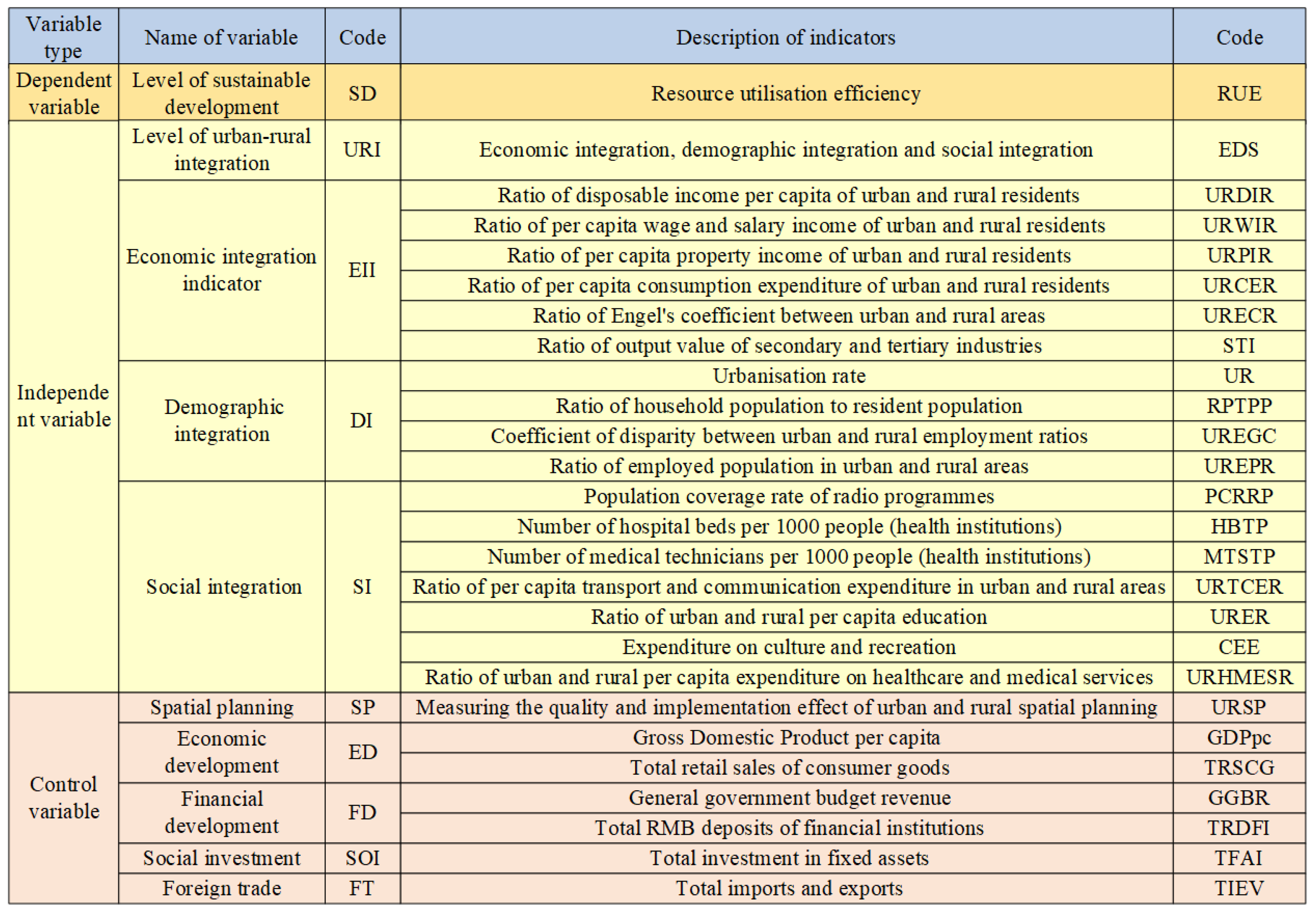
5.1. Experimental Design

Based on the current situation and case analysis of Beijing’s urban–rural fringe, this study analyzes the relationship between urban–rural integration and sustainable development in Beijing from a spatial planning perspective. In this study, the dependent variable selected is the level of sustainable development. The independent variable is the level of urban–rural integration, used to measure the degree of economic, population, and social integration, reflecting the balance between urban and rural areas in resource distribution and social integration. Control variables encompass economic development, spatial planning, financial development, social investment, and foreign trade levels. The specific meanings and codes of the variables used here are illustrated in Figure 5.
The levels of sustainable development and urban–rural integration are SD and URI, including economic, population, and social integration indicators. The equation for the impact of the urban–rural integration level on the sustainable development level under spatial planning is as follows [27]:
SD =   β 0 + β 1 URI + β 2 SP + β 3 ED +   β 4 FD + β 5 SOI + β 6 FT + ϵ
SP refers to the spatial planning level; ED and FD represent the economic and financial development levels, respectively; SOI and FT denote social investment and foreign trade levels; ϵ represents random error;   β 0 is the intercept term; and β 1 ,   β 2 ,   ,   β 6 are the influence coefficients of the independent variables on the dependent variables.
The data for this study are sourced from national public yearbooks, including the Beijing Statistical Yearbook, the Land Change Statistical Yearbook of the Beijing Planning and Natural Resources Commission, and the Statistical Bulletin on National Economic and Social Development of Beijing. Since the economic, social, and demographic data for Beijing before 2009 are not comprehensive, this study uses data from 2009 to 2023 for analysis.

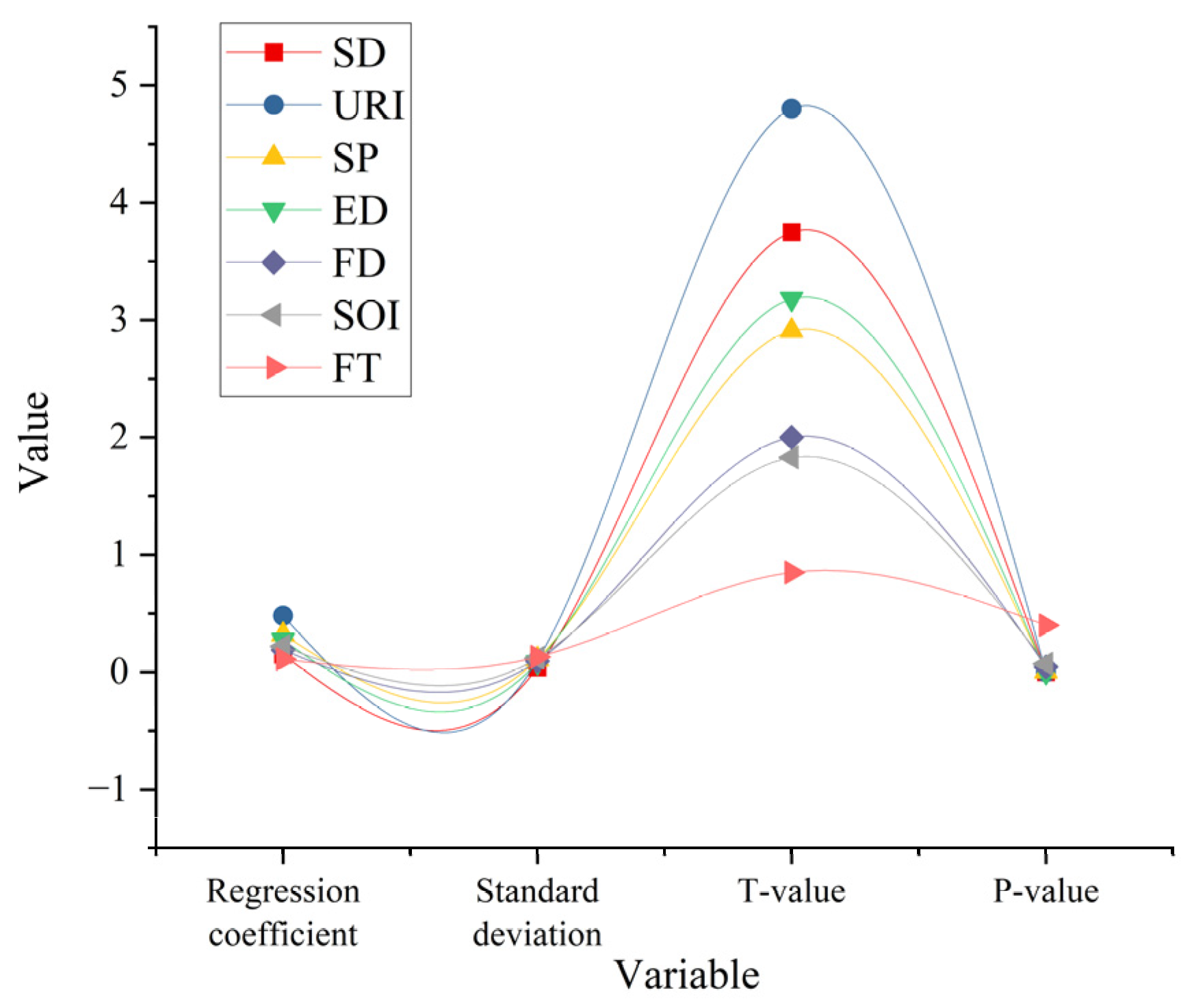
5.2. Analysis of Factors Influencing Sustainable Development of Urban–Rural Integration in Beijing

Figure 6 reveals the regression analysis results of the impact of urban–rural integration on sustainable development from the perspective of spatial planning.
In Figure 6, the regression analysis examines the impact of various variables, including urban–rural integration levels, on sustainable development levels from a spatial planning perspective. The results indicate that urban–rural integration prominently influences sustainable development, with a coefficient β of 0.48, a t-value of 4.8, a standard error of 0.1, and a p-value of 0. This suggests that for each unit increase in urban–rural integration, the sustainable development level rises by 0.48 units. The coefficient β for spatial planning reaches 0.32, with a standard error of 0.11, a t-value of 2.91, and a p-value of 0.005, indicating a significant positive impact on sustainable development levels. The coefficient β for economic development is 0.27, with a standard error, t-value, and p-value of 0.085, 3.18, and 0.002, demonstrating a positive effect on sustainable development. The coefficient β, standard error, t-value, and p-value for financial development are 0.19, 0.095, 2, and 0.045, showing a moderate positive influence. The coefficient β for social investment is 0.22, and its t-value, standard error, and p-value are 1.83, 0.12, and 0.07, illustrating a relatively weak yet positive impact. The coefficient β for foreign trade is 0.11, with a p-value of 0.4, a standard error of 0.13, and a t-value of 0.85, which reveal no significant effect on sustainable development levels. Overall, urban–rural integration has the most remarkable influence on sustainable development levels among the variables. Additionally, spatial planning and economic development play significant roles, with foreign trade showing a negligible impact.
The correlation analysis results of the influence of urban–rural integration on the sustainable development level in the context of spatial planning are depicted in Figure 7.
In Figure 7, there are varying degrees of correlation between sustainable development levels and the different variables. The correlation between sustainable development and urban–rural integration is strong, with a correlation coefficient of 0.78, indicating a close relationship where changes in urban–rural integration markedly affect sustainable development levels. The correlation coefficient with economic development is 0.75, which also reflects a high correlation, demonstrating the evident role of economic development in promoting sustainability. The correlation coefficient with spatial planning is 0.67, suggesting that reasonable spatial planning contributes to sustainable development. The correlation coefficient for financial development is 0.41, while the correlation with social investment is 0.46; although these correlations are relatively weak, they still indicate some level of connection. In contrast, the correlation between foreign trade and sustainable development is the lowest, with a coefficient of only 0.34. Additionally, the variables are interrelated. For instance, the correlation between urban–rural integration and economic development is 0.71, and the correlation between spatial planning and social investment is 0.47. These complex interrelations collectively influence sustainable development levels, with urban–rural integration emerging as a key factor affecting sustainability.

5.3. Management Suggestion and Policy Optimization Scheme Based on the Ecological Protection Red Line and Urban Development Boundary

The ecological protection red line refers to the designated ecological space control range established by the state based on the importance of ecosystem functions and ecological security. Its purpose is to ensure ecological safety and maintain ecological functionality [28]. Urban development boundary is a critical means for guiding construction activities, controlling disorderly expansion, and optimizing resource allocation in urban planning [29,30]. In the context of urban–rural integration, balancing ecological protection with urban development becomes crucial for achieving sustainable development. As the frontier of the urbanization process, Beijing’s urban–rural fringe faces the dual challenge of ecological environment protection and construction development. Hence, this study proposes the following specific policy optimization recommendations tailored to the characteristics of this region, offering practical guidance for policymakers to achieve a coordinated balance between ecological security and economic development.
(1)
Precise delimitation and dynamic adjustment of ecological protection red lines.
The delimitation of ecological protection red lines should be based on scientific research and advanced technological methods, such as remote sensing monitoring, geographic information system (GIS) analysis, and big data assessments. This ensures that the protected areas are ecologically reasonable and align with urban development needs. The ecological environment of Beijing’s urban–rural fringe is complex, encompassing various ecosystems such as mountains, wetlands, and forests. Therefore, a unified delimitation of red lines may have limitations. It is recommended that a refined assessment model that combines ecological sensitivity analysis and carrying capacity calculations be adopted and a tiered and differentiated strategy for delimiting ecological red lines be established. Furthermore, ecosystems are dynamic, and policymakers should implement a dynamic monitoring and adjustment mechanism, utilizing satellite remote sensing and drone inspections to assess ecological conditions in real time. This helps prevent unauthorized development within the red lines and allows timely adjustments based on environmental changes to ensure the synchronized progress of ecological protection and economic development.
(2)
Differentiated zoning management to optimize urban development boundaries.
The development boundaries of the urban–rural fringe should be optimized in line with ecological protection goals and urban development plans. Traditional urban expansion models tend to lead to uncontrolled sprawl, while strict development restrictions may stifle economic vitality. Therefore, a “core protection zone—ecological buffer zone—moderate development zone” three-tier zoning management model should be adopted to ensure that the development intensity in each zone matches the ecological carrying capacity. The core protection zone should be based on ecological red lines with strict controls on human activities. The ecological buffer zone can introduce ecological restoration projects, such as wetland restoration and wasteland greening, to enhance environmental carrying capacity. The moderate development zone can focus on low-carbon industries and ecologically friendly infrastructure construction, provided it meets green development standards. Additionally, it is recommended that an “ecological function—industry compatibility” model be established, aligning regional ecological characteristics with economic development needs to match the most suitable types of industries. For example, ecological tourism can be developed in water conservation areas, and organic agriculture can be promoted in agricultural zones, thereby achieving sustainable urban–rural integration.
(3)
Establishing an ecological compensation mechanism to promote coordinated urban–rural development.
The urban–rural fringe often serves as an ecological barrier for cities, but due to land use restrictions, regional economic development is frequently constrained. Therefore, it is recommended that an ecological compensation mechanism be established to balance the conflict between ecological protection and economic development. On the one hand, the government can set up a dedicated ecological compensation fund to provide financial subsidies for areas that strictly enforce ecological red-line controls. For example, direct subsidies can be provided for agricultural land with development restrictions, or low-interest loans can be offered for ecological restoration projects. On the other hand, the government can implement “green taxation” policies to levy additional taxes on environmentally damaging enterprises, with the revenue used to support environmental protection industries. At the same time, social capital investment in green industries, such as ecological agriculture, clean energy, and forest carbon trading, should be encouraged to enhance the economic feasibility of ecological protection. This, in turn, can strengthen the willingness of residents in the urban–rural fringe to protect the environment and promote regional coordinated development.
(4)
Promoting the construction of ecologically friendly infrastructure.
Infrastructure development in the urban–rural fringe should avoid the high energy consumption and pollution associated with traditional urban expansion, instead adopting an ecologically friendly approach in planning and construction. It is recommended that the government prioritize the promotion of green infrastructure, such as permeable paving roads, rainwater collection systems, and energy-efficient buildings, to reduce the environmental impact of urban development. In terms of transportation planning, greater investment in public transit, bicycle lanes, and pedestrian-friendly systems is recommended to reduce reliance on private car use and lower carbon emissions. Policymakers could adopt public-private partnership models to encourage enterprises to invest in green infrastructure, alleviating financial pressures on the government. For example, Beijing could guide real estate companies, through policy incentives, to integrate ecological parks and green rooftops into new developments to enhance the overall ecological quality of the region. Additionally, the government should establish a green building certification system and offer policy incentives for projects that meet sustainable development standards, thus driving the urban–rural fringe toward green and low-carbon development.
(5)
Strengthening public participation and ecological education to improve social governance effectiveness.
Ecological governance in the urban–rural fringe relies not only on government policies but also on widespread public participation. Therefore, it is recommended that the government enhance ecological protection awareness among residents through legislation, education, and public outreach. For example, community forums, urban–rural planning hearings, and other platforms could be used to involve residents in ecological planning decisions, increasing policy acceptance. Furthermore, ecological education should be strengthened by integrating ecological protection knowledge into school curricula to cultivate environmental awareness among future generations. The government can also utilize social media and digital platforms to provide real-time environmental data to the public, encouraging community oversight of ecological protection policies. For instance, a “citizen reporting platform” model could be adopted, allowing the public to report illegal development activities, fostering a collaborative ecological governance model involving the government, enterprises, and residents.
(6)
Cross-departmental collaborative governance to enhance policy implementation efficiency.
Ecological governance in the urban–rural fringe involves multiple departments, such as environmental protection, housing and urban–rural development, agriculture, and transportation. The traditional approach of separate governance often leads to disjointed policy implementation. Therefore, it is recommended to establish a cross-departmental collaborative governance mechanism to integrate data resources from different departments, thereby improving the scientific basis for policy formulation and the efficiency of execution. For example, an “Urban-Rural Ecological Governance Big Data Platform” could be established to integrate multi-source data, such as satellite remote sensing, land use, and population mobility, providing accurate decision-making support for the government. Additionally, regular cross-departmental coordination meetings should be held to promote the coordinated management of environmental policies, industrial planning, and infrastructure construction. Furthermore, the government can adopt a “multi-plan integration” approach, incorporating ecological red lines, urban development boundaries, and industrial development plans into a unified system. This can avoid policy conflicts and enhance the overall effectiveness of urban–rural governance.
Through the aforementioned policy optimization proposals, this study provides practical and feasible suggestions for policymakers that not only ensure ecological safety but also promote the sustainable development of urban–rural integration. Based on the precise delineation of ecological protection red lines, differentiated zoning management, and the optimization of urban development boundaries, the proposed measures ensure that urban and rural development aligns with ecological carrying capacity. Meanwhile, the operational feasibility and execution capacity of policies are further enhanced by establishing an ecological compensation mechanism, advancing green infrastructure construction, strengthening public participation, and enhancing cross-departmental collaborative governance. These measures contribute to the sustainable development of Beijing’s urban–rural fringe and provide policy insights for urban–rural integration in other metropolitan areas. Ultimately, a win–win situation can be achieved for ecological protection and economic development.

6. Discussion

This study, in analyzing the sustainable development path of Beijing’s urban–rural fringe, reveals the relationship between urban–rural integration, spatial planning, and sustainable development and presents a series of important policy recommendations. These suggestions provide valuable guidance for the planning and policy formulation of similar urban areas, particularly in terms of improving resource allocation, enhancing public services, and protecting the ecological environment. However, the study also has some limitations, particularly regarding the timeliness of data and sample representativeness. To enhance the broader applicability and practical guidance, future studies should expand the sample scope and specifically select regions with different economic development levels, resource endowments, and socio-cultural backgrounds for comparative analysis. Future research could focus on the urban–rural integration processes in eastern and western cities, as well as in developed and underdeveloped areas, exploring the differences and common patterns under varying social, economic, and environmental conditions. In the process of urban–rural integration, cultural and social conditions often have a profound impact on the effectiveness of policy implementation, particularly in regional cultural identity, resident participation, and local governance structures. Cultural factors may influence residents’ acceptance and cooperation with policies related to ecological protection and public service improvement, which are crucial to the success of these policies. Therefore, future research should give greater attention to the role of cultural factors in urban–rural integration, particularly in how the integration of cultural differences can promote the success of urban–rural integration. Furthermore, the long-term effects of policy implementation have not been fully considered in this study. Future research could employ longitudinal studies to track the long-term impacts of policies in different regions, allowing for the evaluation of the practical effects of policy adjustments on sustainable development. With these additions and improvements, future research could more comprehensively and deeply explore sustainable development paths for urban–rural integration, providing policymakers with more actionable and targeted recommendations.

7. Conclusions

This study, based on an in-depth analysis of the sustainable development path of Beijing’s urban–rural fringe, adopts a combined quantitative and qualitative methods approach, including data collection, spatial analysis, case studies, regression analysis, and correlation analysis. The study’s main contribution lies in revealing the significant differences in resource allocation, ecological environment, and social development between urban–rural fringes. Moreover, the important influence of the levels of urban–rural integration, spatial planning, and economic development on sustainable development is verified through scientific empirical analysis. The study finds a significant positive correlation between the improvement of urban–rural integration levels and sustainable development levels, with spatial planning and economic development also having a positive driving effect on sustainable development. Thus, advancing the effective implementation of urban–rural integration and spatial planning can remarkably enhance the sustainable development levels of urban–rural fringes.
In terms of policy and planning impacts, this study provides valuable insights into urban–rural integration, spatial planning, and ecological protection. By formulating more detailed spatial planning policies and promoting the coordinated development of economic growth and ecological protection, the government can better advance the sustainable development of urban–rural fringes. Specifically, in areas such as public services, resource allocation, and ecological protection, the study provides empirical evidence and theoretical support for policymakers. Concurrently, it offers concrete policy optimization proposals, such as establishing ecological compensation mechanisms and zonal management. Additionally, the study emphasizes the importance of strengthening urban–rural integration planning, increasing social participation, and advancing green infrastructure development. It provides specific directions for future planning and policy formulation. These findings have significant practical implications for improving the sustainable development conditions of urban–rural fringes and offer valuable references for urban–rural integration and sustainable development in other regions.

Funding

This research received no external funding.

Institutional Review Board Statement

Not applicable.

Informed Consent Statement

Not applicable.

Data Availability Statement

The data for this study come from national public yearbooks, including the Beijing Municipal Statistical Yearbook, the Statistical Yearbook of Land Changes of the Beijing Municipal Commission of Planning and Nature, and the Statistical Bulletin of National Economic and Social Development of Beijing. These yearbooks can be found at https://nj.tjj.beijing.gov.cn/nj/main/2023-tjnj/zk/e/indexch.htm (accessed on 1 March 2022); https://ghzrzyw.beijing.gov.cn/zhengwuxinxi/sjtj/tdbgdctj/ (accessed on 5 March 2022); https://tjj.beijing.gov.cn/tjsj_31433/sjjd_31444/202403/t20240319_3594001.html (accessed on 7 March 2022).

Conflicts of Interest

The author declares no conflict of interest.

References

  1. Wojewodzki, M.; Wei, Y.; Cheong, T.S.; Shi, X. Urbanisation, Agriculture and Convergence of Carbon Emissions Nexus: Global Distribution Dynamics Analysis. J. Clean. Prod. 2023, 385, 135697. [Google Scholar] [CrossRef]
  2. Rong, X.; Jin, Y. How Can Large-Scale Housing Provision in the Outskirts Benefit the Urban Poor in Fast Urbanising Cities? Case Beijing Cities 2023, 132, 104066. [Google Scholar] [CrossRef]
  3. Feng, C.; Zhang, H.; Xiao, L.; Guo, Y. Land Use Change and Its Driving Factors in the Rural-Urban Fringe of Beijing: A Production-Living-Ecological Perspective. Land 2022, 11, 314. [Google Scholar] [CrossRef]
  4. Hu, Q.; Shen, W.; Zhang, Z. How Does Urbanisation Affect the Evolution of Territorial Space Composite Function? Appl. Geogr. 2023, 155, 102976. [Google Scholar] [CrossRef]
  5. Zhang, Z.; Zhao, W.; Liu, Y.; Pereira, P. Impacts of Urbanisation on Vegetation Dynamics in Chinese Cities. Environ. Impact Assess. Rev. 2023, 103, 107227. [Google Scholar] [CrossRef]
  6. Fang, G.; Sun, X.; Liao, C.; Xiao, Y.; Yang, P.; Liu, Q. How Do Ecosystem Services Evolve across Urban–Rural Transitional Landscapes of Beijing-Tianjin-Hebei Region in China: Patterns, Trade-Offs, and Drivers. Landsc. Ecol. 2023, 38, 1125–1145. [Google Scholar] [CrossRef]
  7. Pan, W.; Wang, J.; Li, Y.; Lu, Z. Spatial Pattern of Urban-Rural Integration in China and the Impact of Geography. Geogr. Sustain. 2023, 4, 404–413. [Google Scholar] [CrossRef]
  8. Hoffmann, E.M.; Schareika, N.; Dittrich, C.; Schlecht, E.; Sauer, D.; Buerkert, A. Rurbanity: A Concept for the Interdisciplinary Study of Rural-Urban Transformation. Sustain. Sci. 2023, 18, 1739–1753. [Google Scholar] [CrossRef]
  9. Özatağan, G.; Eraydin, A. Binaries Again! Revisiting the Urban-Rural Question through Geographies of Discontent. Habitat Int. 2024, 152, 103162. [Google Scholar] [CrossRef]
  10. Cong, Y.; Zhai, Y.; Dong, Y.; Zhao, Z.; Yang, G.; Shen, H. The Influence of Tourism’s Spatiotemporal Heterogeneity on the Urban–Rural Relationship: A Case Study of the Beijing-Tianjin-Hebei Urban Agglomeration, China. Sustainability 2024, 16, 7468. [Google Scholar] [CrossRef]
  11. Niu, K.; Xu, H. Urban–Rural Integration and Poverty: Different Roles of Urban–Rural Integration in Reducing Rural and Urban Poverty in China. Soc. Indic. Res. 2023, 165, 737–757. [Google Scholar] [CrossRef]
  12. Xu, J.; Zeng, Z.; Xi, Z.; Peng, Z.; Chen, G.; Zhu, X.; Chen, X. Research on Sustainable Urban–Rural Integration Development: Measuring Levels, Influencing Factors, and Exploring Driving Mechanisms—Taking Eight Cities in the Greater Bay Area as Examples. Sustainability 2024, 16, 3357. [Google Scholar] [CrossRef]
  13. Jia, M.; Liu, A.; Narahara, T. The Integration of Dual Evaluation and Minimum Spanning Tree Clustering to Support Decision-Making in Territorial Spatial Planning. Sustainability 2024, 16, 3928. [Google Scholar] [CrossRef]
  14. Mao, D.; Zhang, J.; Lu, H.; Guo, R. Assessment and Analysis of the Balance between Economic Development and Ecological Environment Protection and Its Implementation Strategy Derived from Spatial Planning—Take Three Heterogeneous and Representative Provinces in China as an Example. Heliyon 2024, 10, e23785. [Google Scholar] [CrossRef]
  15. Wei, L.; Lin, X.; Lu, Y.; Sun, J. Rural territorial types in urban and rural integrated areas taking Jiangsu Province in China as an example. Environ. Dev. Sustain. 2024, 26, 18903–18928. [Google Scholar] [CrossRef]
  16. Ihle, T.; Jahr, E.; Martens, D.; Muehlan, H.; Schmidt, S. Health Effects of Participation in Creating Urban Green Spaces—A Systematic Review. Sustainability 2024, 16, 5000. [Google Scholar] [CrossRef]
  17. Cuadrado-Roura, J.R. Population Imbalances in Europe. Urban Concentration versus Rural Depopulation. Reg. Sci. Policy Pract. 2023, 15, 713–716. [Google Scholar] [CrossRef]
  18. Javed, M.S.; Nisar, U.; Warsi, S.H.; Billah, M.M.; Karkkulainen, E.A. Mapping the Disparities between Urban and Rural Areas in the Global Attainment of Sustainable Development Goals, Economic and Social Aspects of Global Rural-Urban Migration. Educ. Adm. Theory Pract. 2024, 30, 2052–2064. [Google Scholar] [CrossRef]
  19. Omweri, F.S. A Systematic Literature Review of E-Government Implementation in Developing Countries: Examining Urban-Rural Disparities, Institutional Capacity, and Socio-Cultural Factors in the Context of Local Governance and Progress towards SDG 16.6. Int. J. Res. Innov. Soc. Sci. 2024, 8, 1173–1199. [Google Scholar] [CrossRef]
  20. Cattaneo, A.; Adukia, A.; Brown, D.L.; Christiaensen, L.; Evans, D.K.; Haakenstad, A.; McMenomy, T.; Partridge, M.; Vaz, S.; Weiss, D.J. Economic and Social Development along the Urban–Rural Continuum: New Opportunities to Inform Policy. World Dev. 2022, 157, 105941. [Google Scholar] [CrossRef]
  21. Li, X.; Li, M.; Wu, Y. Research on Effects of Integration of Primary, Secondary, and Tertiary Industries in Rural Areas of Developing Countries: An Approach of Rural Capital Subsidies. Asia-Pac. J. Account. Econ. 2024, 31, 457–476. [Google Scholar] [CrossRef]
  22. Chen, X.; Huang, Z.; Luo, C.; Hu, Z. Can Agricultural Industry Integration Reduce the Rural–Urban Income Gap? Evidence from County-Level Data in China. Land 2024, 13, 332. [Google Scholar] [CrossRef]
  23. Stoett, P.; Scrich, V.M.; Elliff, C.I.; Andrade, M.M.; Grilli, N.D.M.; Turra, A. Global Plastic Pollution, Sustainable Development, and Plastic Justice. World Dev. 2024, 184, 106756. [Google Scholar] [CrossRef]
  24. Sahoo, S.; Goswami, S. Theoretical Framework for Assessing the Economic and Environmental Impact of Water Pollution: A Detailed Study on Sustainable Development of India. J. Future Sustain. 2024, 4, 23–34. [Google Scholar] [CrossRef]
  25. Su, K.; He, D.; Wang, R.; Han, Z.; Deng, X. Assessment of Natural Resource Endowment and Urban-Rural Integration for Sustainable Development in Xinjiang, China. J. Clean. Prod. 2024, 450, 142046. [Google Scholar] [CrossRef]
  26. He, Y.; Wen, C.; Fang, X.; Sun, X. Impacts of urban-rural integration on landscape patterns and their implications for landscape sustainability: The case of Changsha, China. Landsc. Ecol. 2024, 39, 129. [Google Scholar] [CrossRef]
  27. Zhan, L.; Wang, S.; Xie, S.; Zhang, Q.; Qu, Y. Spatial path to achieve urban-rural integration development–analytical framework for coupling the linkage and coordination of urban-rural system functions. Habitat Int. 2023, 142, 102953. [Google Scholar] [CrossRef]
  28. Deng, J.; Xie, Y.; Wei, R.; Ye, C.; Wang, H. Application of Machine Learning in Ecological Red Line Identification: A Case Study of Chengdu-Chongqing Urban Agglomeration. Diversity 2024, 16, 300. [Google Scholar] [CrossRef]
  29. Yuan, C.; Ma, N.; Xiong, X. The Impact of Urban Growth Boundary on Urban Sprawl: Evidence from China. Reg. Environ. Change 2024, 24, 157. [Google Scholar] [CrossRef]
  30. Shi, Z.; Huo, J.; Zhu, W.; Ma, R.; Xue, H.; Wang, Z. Comprehensive Evaluation of Urban Development Suitability Based on Constraints and Development Factors: A Case Study of the Central Urban Area of Zhengzhou, China. Prog. Phys. Geogr. Earth Environ. 2024, 48, 24–44. [Google Scholar] [CrossRef]
Figure 1. Beijing district.
Sustainability 17 01857 g001
Figure 2. Basic statistical information for the urban–rural fringe in Beijing. (a) Population size; (b) population distribution in 2022; (c) urbanization rate; (d) GDP statistics; (e) percentage of tertiary sector; (f) changes in the number of villages; (g) disposable income of the population.
Sustainability 17 01857 g002aSustainability 17 01857 g002b
Figure 3. Land use changes in the urban–rural fringe of Beijing. (a) Land use change in Beijing; (b) land use in urban villages in Beijing.
Sustainability 17 01857 g003
Figure 4. Comparison of changes in ecological land and construction land in Beijing. Changes in the area covered by ecological land versus construction land in Beijing from 2009 to 2023.
Sustainability 17 01857 g004
Figure 5. The meanings and codes for the variables. Indicators are categorized into dependent, independent, and control variables.
Sustainability 17 01857 g005
Figure 6. Results of regression analysis.
Sustainability 17 01857 g006
Figure 7. Results of correlation analysis.
Sustainability 17 01857 g007
Disclaimer/Publisher’s Note: The statements, opinions and data contained in all publications are solely those of the individual author(s) and contributor(s) and not of MDPI and/or the editor(s). MDPI and/or the editor(s) disclaim responsibility for any injury to people or property resulting from any ideas, methods, instructions or products referred to in the content.

