1. Introduction
Coastal dynamics are defined by a complex interplay of geological, climatic, and anthropogenic processes. These processes are responsible for the continuous reshaping of the interface between marine (water) and terrestrial (land) environments. The morphological evolution of coastal systems is the result of complex interactions between geomorphological characteristics, climatic regimes, ecological protective mechanisms, and human interventions. Particle mobilization and sedimentary transport represent fundamental mechanisms through which coastal landscapes undergo transformation, enabling the displacement of material from source regions to depositional zones. These mechanisms operate across a range of temporal scales, from immediate meteorological events such as storm surges and wave dynamics to long-term geological phenomena such as tectonic movements and glacial cycles [
1]. The resulting geomorphological modifications are manifested through erosional and accretional processes, which systematically alter coastal topography. The redistribution of sedimentary materials not only reflects the inherent dynamism of coastal systems but also serves as a critical indicator of environmental change, revealing the complex interactions between lithospheric, hydrospheric, and atmospheric components. An understanding of these complex processes provides crucial insights into the resilience, vulnerability, and potential future transformations of coastal systems in the context of environmental conditions that are subject to continuous change [
2].
Consequently, the majority of coastlines are naturally dynamic, meaning they are perpetually engaged in an ongoing environmental dialectic. This dialectic is defined by a dynamic interaction between the ocean (water) and the continent (defined by its morphology). In this interaction, the ocean exerts an impact on the continent that receives it, modifying the continent’s morphology in the process (either through erosion or accretion). The receding water transports material from the continent, which it will subsequently act upon at the coastline, thereby perpetuating an endless dialectic in the littoral zone. The environmental dialectic is fundamentally determined by the intrinsic morphological characteristics of coastal zones, distinguishing between structural formations (cliffs, reefs, flats) and sedimentary environments (beaches) with variable geometric configurations [
3].
The objective of the research is to analyses the coastal transformation of Lake Pontchartrain, including New Orleans city, with a particular focus on the quantitative assessment of anthropogenic landscape modifications. The study aims to evaluate landscape changes through chronological erosion and accretion measurements, categorizing spatial-temporal variations induced by human intervention. By employing geospatial analysis and historical analysis, the research will document the extent of landscape alterations, assess impact, and provide data on coastal ecosystem transformation mechanisms. This case study is part of a larger investigation with a primary goal of generating awareness for landscape reconstruction and sustainable coastal management strategies.
The research addresses the complex geomorphological evolution of Lake Pontchartrain, critically examining fragmented approaches in previous studies. Existing research predominantly focused on isolated subsectors, limiting comprehensive understanding. This study proposes an integrated methodological approach, systematically analyzing urban environments, nature preserves, marshes, and tidal ecosystems to provide a holistic interpretation of regional landscape transformations.
1.1. Perception of the Physical Environment
Building upon previous research by the investigative group, a four-phase conceptual framework is proposed for comprehending and transforming ecosystem perception into territorial configuration: submission, adaptation, conquest, and respect. These phases, as defined by González et al. [
3], represent a systematic approach to understanding the transition from an undifferentiated “site” to a meaningful “place” through progressive human–ecosystem interaction.
Submission phase: Human settlements strategically position themselves to mitigate environmental risks, establishing urban perimeters distant from maritime boundaries. Defensive strategies prioritize protection against meteorological threats, potential maritime invasions, and unpredictable natural phenomena;
Adaptation phase: Communities develop ecological understanding, systematically integrating environmental observations into settlement patterns. Natural resource optimization emerges, enabling sustainable coexistence between human infrastructure and surrounding ecological systems;
Conquest phase: Technological and cognitive advancements enable human intervention and territorial control. Comprehensive knowledge, sophisticated technological tools, and strategic capabilities facilitate environmental transformation, potentially generating significant ecological modifications and species displacement;
Respect phase: Emerging paradigm emphasizing balanced ecological interaction, where engineering interventions integrate environmental consciousness, social responsibility, and systemic equilibrium. Holistic approaches prioritize sustainable development and comprehensive ecosystem preservation.
This research contributes to a larger investigation exploring the correlation between the four phases of physical environment perception and the corresponding landscape states. In order to elucidate this relationship, it is essential to define the four landscape states: original, constructed, destroyed, and reconstructed. The definitions employed in this study are derived from Martin-Anton [
4] and González et al.’s [
5] conceptual framework, which was specifically developed within the context of littoral landscape dynamics.
Original Landscape: Represents geospatial domains of exceptional ecological and territorial integrity, characterized by preservation strategies that maintain original environmental configurations. Emphasizes protection mechanisms ensuring conservation of unique spatial and ecological attributes;
Constructed landscape: Synthesizes natural ecosystems with anthropogenic interventions, illustrating dynamic interactions between environmental systems and human cultural development. Reflects the evolutionary trajectory of spatial configurations through social and technological transformations;
Destructed landscape: Signifies comprehensive territorial disintegration encompassing environmental, social, and infrastructural collapse. Represents systemic abandonment where ecological, communicational, and sustainable frameworks experience progressive deterioration and functional fragmentation;
Re-constructed landscape: Embodies strategic rehabilitation processes aimed at reconstructing spatial configurations to their optimal state. Involves systematic restoration, dismantling previous interventions, and reestablishing original ecological and territorial potential through comprehensive intervention strategies.
In the context of this research, two fundamental coastal transformation processes are defined: erosion and accretion. The phenomenon of coastal erosion is conceptualized as a consequence of the interaction between human-induced activities and natural environmental changes, whereby the equilibrium of coastal dynamics (waves, currents, wind) is disrupted. The long-term loss of sediments of coastal zone results in the destruction process of the coastline retreat and beach erosion [
6]. This process is characterized by two critical conditions: the intensity of current flow capable of mobilizing basal sediments and the imbalance between sediment supply and disappearance [
7]. Accretion, in contrast, represents the accumulation of sediments in specific coastal locations, resulting in modifications to the shoreline through natural deposition or anthropogenic intervention. Accretion mechanisms include direct sand deposition to increase beach width and the construction of infrastructure such as ports or artificial islands. Studies by Martín et al. [
8] indicate that land reclamation through artificial islands is significantly more extensive in regions such as China, Japan, Korea, and the Persian Gulf, with greater relevance in port zones than residential areas.
1.2. Study Area: Site Description
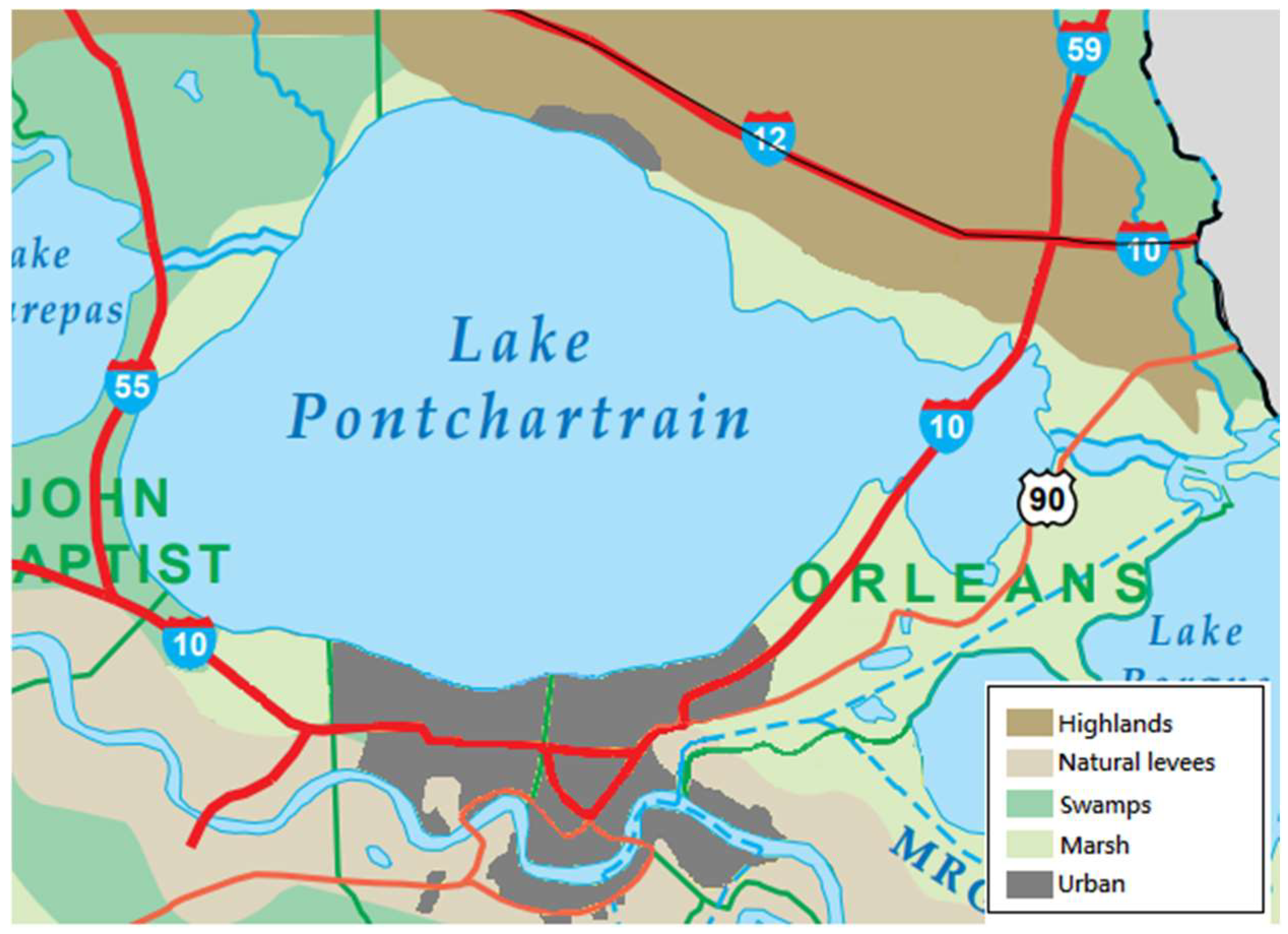
Pontchartrain Lake, a brackish water body situated in southeastern Louisiana, represents the second-largest saline lake in the United States and the most extensive lacustrine system within Louisiana’s territorial boundaries. The lake is characterized by an ovoid morphological configuration, with a span of 64.4 km from east to west and 38.6 km from north to south. Its southern shoreline delineates the northern boundary of New Orleans, while its northern littoral zone encompasses the municipalities of Mandeville and Madisonville. The northeastern sector is demarcated by the urban settlement of Slidell. From a hydrological perspective, the lake is part of a complex interconnected system. It is linked to Lake Maurepas to the west via the Manchac Pass and to Lake Borgne in the east via the Rigoleto Strait. The latter subsequently interfaces with the Gulf of Mexico, creating a dynamic estuarine network that is characteristic of the Louisiana coastal ecosystem.
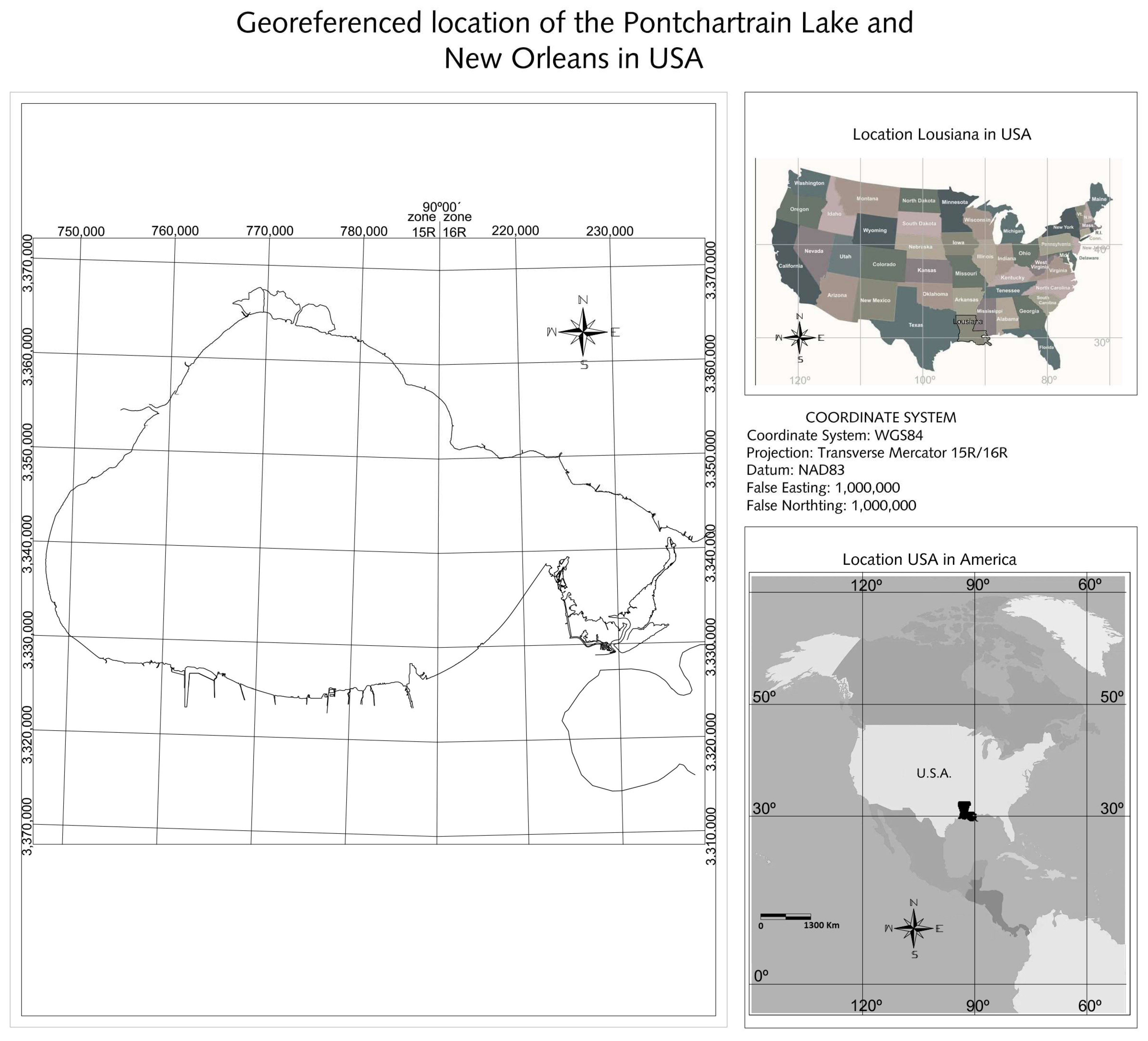
New Orleans is situated in the Mississippi River Delta, approximately 29.9511° N and 90.0715° W (
Figure 1). It is positioned at the confluence of the Mississippi River and Lake Pontchartrain, approximately 177 km (110 miles) from the Gulf of Mexico. The city’s geographical location renders it highly susceptible to frequent hurricanes and storms, with predominant wind vectors originating from the southeast. The occurrence of extreme wind gusts during the hurricane season (June to November) has a significant impact on wave dynamics, with the potential to generate considerable wave heights that contribute to the processes of coastal erosion and flooding. The urban infrastructure is constructed on a series of ancient deltaic channels and lobes, forming a relatively flat and low-lying terrain with elevations ranging between 0 and 6 m above sea level [
9]. However, more recent investigations by Dixon et al. [
10] indicate that New Orleans experienced rapid subsidence in the three years preceding Hurricane Katrina (August 2005). The eastern sector of the city historically presents the highest subsidence rates in southern Louisiana, featuring a topography 3 to 5 m below sea level.
According to Törnqvist et al. [
11], the confluence of topographical characteristics—specifically the region’s low-altitude configuration —and its geographical positioning render New Orleans exceptionally susceptible to climate change impacts and sea-level rise, presenting complex environmental management challenges that necessitate comprehensive adaptive strategies for mitigating potential ecological and infrastructural vulnerabilities.
The research was conducted within the littoral zone encompassing Lake Pontchartrain’s coastal system (
Figure 1), which is situated in the Caribbean Sea and extends from the north coast of New Orleans City to the coast of Irish Bayou.
The paleogeographic evolution of the study area provides insight into the formation of the Mississippi Delta over geological time. In their 2009 study, Flocks et al. [
12] describe Lake Pontchartrain as a shallow barrier estuary with a recent geological evolution dating to the Pleistocene. This evolution is marked by the formation of multiple glacial cycle terrace formations. During the Late Pleistocene epoch, (approximately 18,000 years ago) when sea levels were substantially depressed, fluvial erosion of the terraces occurred, resulting in the transportation of sediments to the continental shelf margin. Approximately 4000 years ago, the progradation of the St. Bernard delta along the southern basin margin resulted in the enclosure of the bay and the formation of Lake Pontchartrain in its current configuration. In addition, Van Asselen et al. [
13] provide further insight by indicating that approximately 5000 years ago, the delta’s deposition center was situated to the west of the modern delta. Approximately 3800 years ago, a significant avulsion of the Mississippi River created a new course that enclosed the ancient bay, forming Lake Pontchartrain. Subsequently, approximately 2500 years ago, the Metairie–Gentilly distributary channel was activated, contributing fluvio-deltaic sediments to the region and ultimately establishing the Mississippi River’s current course around 1000 years ago. This paleogeographic evolutionary process generated a variety of sedimentary environments, including distributary channels, cypress swamps, and sand barriers. As a result, New Orleans was situated upon a sedimentary bed that was primarily composed of clay, silt, and sand.
A comprehensive study conducted by the U.S. Army Corps of Engineers [
14] reveals that the salinity of the Lake Pontchartrain estuary fluctuates between 0.5 and 15 parts per thousand. Historically, submerged aquatic vegetation (SAV) proliferated extensively along the lake’s shorelines. However, anthropogenic shoreline modifications, increased water turbidity, and excessive algal growth precipitated a dramatic decline in total SAV coverage, with an approximate 90% reduction between 1954 and 1998. Although the La Niña phenomenon between 1998 and 2001 temporarily restored submerged aquatic vegetation (SAV) densities to 80% of the 1953 baseline, subsequent ecological disruptions, including drought conditions and the destructive impacts of Hurricane Katrina and subsequent hurricanes between 2005 and 2012, caused extensive SAV degradation. By 2016, submerged aquatic vegetation (SAV) coverage had diminished to approximately 10% of its 1953 historical extent, indicating a significant ecological transformation in the Lake Pontchartrain ecosystem.
The hydrodynamic circulation within Lake Pontchartrain is subject to a complex interaction of wind-generated waves, freshwater inflows and tidal fluctuations. Wind-induced bottom currents exceeding 10 cm/s have been observed, resulting in the generation of suspended sediment concentrations in excess of 100 mg/L. The predominant direction of water movement is from west to east, with the lake’s waters flowing towards the Mississippi Sound during flood events. Additionally, variations in sea level through narrow passes induce intense tidal currents in the eastern sector of the lake. This circulation system generates a distinctive two-gyre pattern centered within the lake, characterized by robust currents along the shorelines and attenuated flows in the central region. The intricate hydrodynamic configuration facilitates the resuspension of sediment during high-energy events, which consequently escalates water turbidity [
15]. The complex interaction of these hydrological mechanisms demonstrates the dynamic nature of the ecological and sedimentary processes occurring within Lake Pontchartrain.
The study area exhibits a humid subtropical climate characterized by tropical air masses dominating meteorological conditions during spring and summer, with continental cold fronts inducing substantial temperature variations throughout autumn and winter. Climatic dynamics are significantly modulated by extensive aquatic surfaces, including lakes, streams, and the Gulf of Mexico. Precipitation patterns demonstrate two well-defined rainy periods: summer precipitation (June–September) and intense winter rainfall (December–March), with an average of 119 precipitation days annually. Temperature regime reveals a mean annual temperature of 69.7 °F (21 °C), encompassing average maximum temperatures of 77.1 °F (25 °C) and minimum temperatures of 62.3 °F (17 °C), as documented by the U.S. Army Corps of Engineers [
14]. This climatic configuration reflects the complex interplay between regional geographical features and atmospheric circulation patterns characteristic of the Gulf Coast region.
Vegetation in New Orleans and Lake Pontchartrain includes diverse ecosystems such as marshlands, swamps, and bald cypress forests. These ecological zones serve as vital wildlife habitats and function as natural flood mitigation buffers. The progressive alteration of the region’s hydrology and subsidence dynamics can be attributed to temporal urban development. In the initial decade of the nineteenth century, the majority of New Orleans was covered by cypress swamps. In the subsequent decades, extensive logging of cypress trees and the construction of canals for the transportation of timber led to the drainage of groundwater and the intrusion of saltwater. Between the years 1891 and 1939, the cypress swamps had nearly disappeared, with the initial indications of subsidence becoming apparent. By 1979, the majority of the area had undergone comprehensive urbanization, which fundamentally transformed the landscape’s ecological and geomorphological characteristics [
13]. This anthropogenic landscape modification represents a significant ecological transition, demonstrating the profound impact of human intervention on natural ecosystems.
1.3. Historical and Spatial Analysis of Littoral Landscape Evolution in the Study Area
New Orleans, established in 1718, evolved into a pivotal location at the convergence of the Mississippi River and the Caribbean Sea. It has undergone numerous territorial transformations, from its initial incorporation into the Viceroyalty of New France to its eventual incorporation into the United States in 1803 ciudad [
16,
17]. Given that approximately 60% of the urban area is situated below sea level, with elevations reaching as low as −1.4 m MSL [
13], it is unsurprising that the city has historically developed intricate drainage and hydraulic infrastructure systems. The construction of a comprehensive drainage system between 1900 and 1920 precipitated a real estate boom that expanded the urban surface area by 700%. This transformation involved the conversion of ancient cypress swamps into residential zones [
18]. Similarly, the city’s drainage system has undergone significant modifications over time.
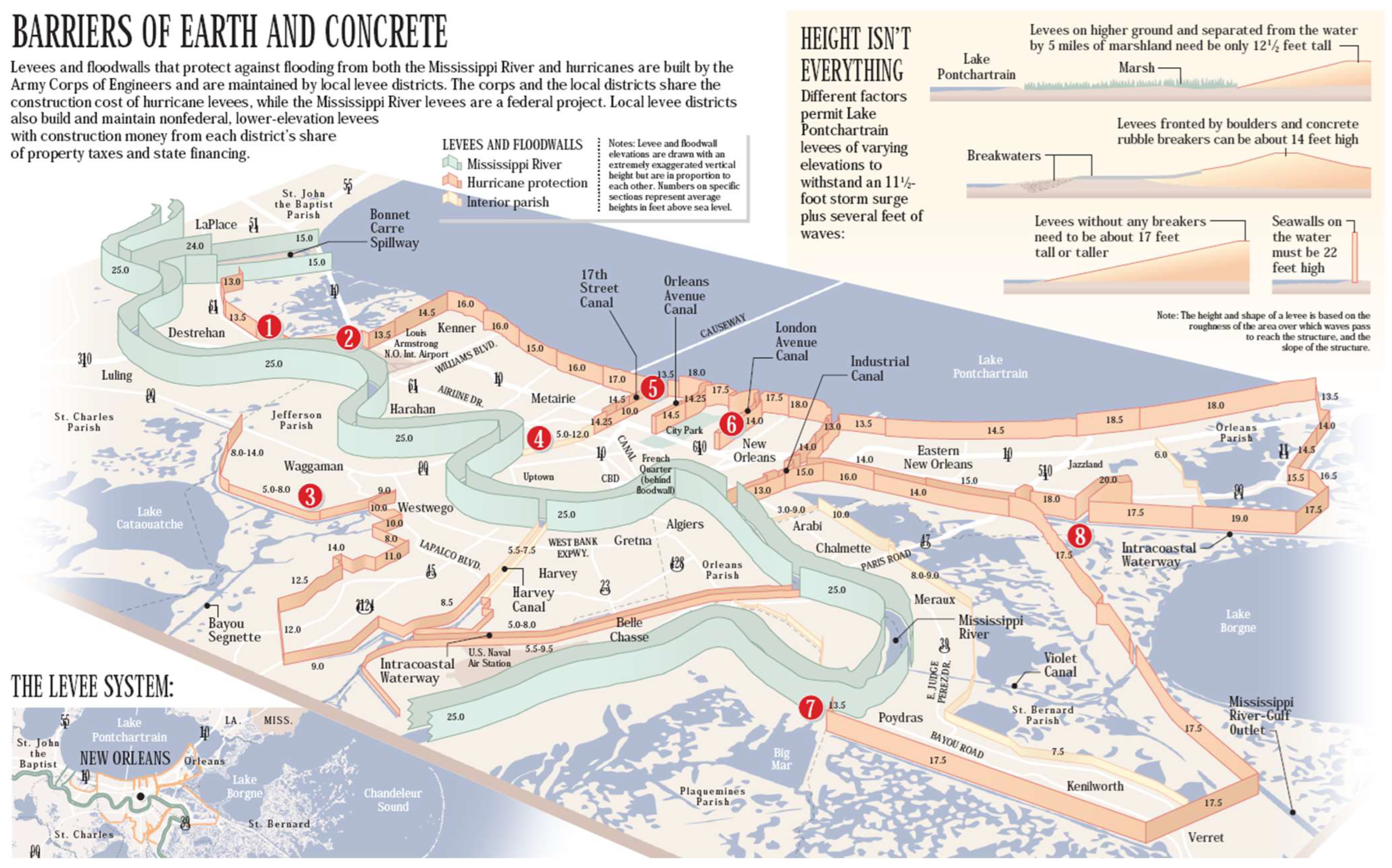
Figure 2 illustrates the design elevations of the flood protection system across the New Orleans region, as outlined by Seed et al. [
19].
The urban development of the area was marked by a series of engineering interventions aimed at mitigating the risk of flooding. These included the excavation of approximately 58 km of drainage channels between 1833 and 1878. The port subsequently consolidated itself as a crucial commercial center, experiencing exponential growth after the completion of the levees in 1879 [
20]. The city has served as a cultural crucible, with French, Spanish, African, and American influences melding to generate innovations such as the birth of jazz and to confront racial segregation challenges.
The pivotal moment in New Orleans’ contemporary history occurred with the arrival of Hurricane Katrina in 2005. This event brought to light shortcomings in the levee system and illuminated the existence of significant social inequalities. In the aftermath of the disaster, over
$14.6 billion was invested in infrastructure improvements, resulting in the establishment of the Southeast Louisiana Flood Protection Authority to oversee protection projects [
14]. The city has continued its reconstruction process, implementing strategies to address the challenges posed by its complex geography and to enhance resilience against climate change and natural threats.
The evolution of the coastal landscape in the study area is characterized by historical development.
Table 1 below illustrates the significant interventions and projects aimed at restoring and reclaiming land through wetland creation and restoration, utilizing techniques such as artificial island construction and native vegetation replantation in New Orleans City. This compilation of major works executed throughout New Orleans’ history is based on Campanella (2012) [
18] and subsequent research.
The northern coast of Jefferson Parish has undergone a substantial infrastructural transformation since the early 20th century. The initial interventions included the strategic construction of piers in Bucktown and Bonnabel, which facilitated maritime transportation. In the 1930s, dredging projects were implemented with the objective of improving the navigability of Lake Pontchartrain. A significant achievement was the construction of the Lake Pontchartrain Causeway in the 1950s, an extensive 38 km infrastructure project. Subsequent decades were marked by coastal restoration initiatives, including the construction of breakwaters and the rehabilitation of wetlands. In the 21st century, efforts have been directed towards infrastructure renovation and the development of recreational facilities, reflecting a sustained commitment to the continuous evolution of coastal landscape management [
21].
The Lake Pontchartrain Causeway represents a critical infrastructural engineering achievement, spanning approximately 50 km and connecting New Orleans and Covington. Comprising two parallel bridges, the structure extends 38 km directly over Lake Pontchartrain, establishing it as the world’s longest continuous water-spanning bridge. Engineered with precise hydrological considerations, the bridge features a consistent vertical clearance of 4.90 m, strategically incorporating two navigational lift spans of 7.60 m to accommodate maritime traffic. Originally conceptualized in 1920 as a proposal for artificial island interconnection financed through land sales, the project materialized under the leadership of James E. Walters, who was appointed to a dedicated commission in 1948. The initial two-lane bridge was inaugurated in 1956, with a complementary parallel structure, 15 m longer, commissioned in 1969, enhancing regional transportation infrastructure [
22]. The bridge construction necessitated the development of a comprehensive 40-acre assembly facility strategically positioned on the northern shoreline of Lake Pontchartrain. The infrastructure engineering project required the precise excavation of a navigational canal, meticulously dimensioned at 366 m in length, 4.57 m in width, and 3.66 m in depth. This engineered waterway was specifically designed to facilitate systematic maritime logistics, enabling specialized barges to efficiently transport prefabricated structural components (including steel pile foundations, load-bearing girders, and modular deck sections) from the manufacturing plant directly to the bridge construction site. The canal’s geometric specifications were optimized to ensure seamless material transportation and minimize logistical constraints during the complex infrastructure development process [
23].
The Lake Pontchartrain Causeway expansion project, overseen by Boh Bros., incorporated cutting-edge infrastructure design elements, including low-gradient ramps and meticulously planned toll platforms. The project employed the Construction Manager at Risk (CMAR) methodology, which entailed the incorporation of 12 safety shoulder segments along the existing bridge. Prefabricated components were constructed in a controlled environment and subsequently transported by maritime vessels, thereby avoiding any disruption to the surrounding traffic. The innovative construction approach, validated by the American Society of Civil Engineers [
24], involved coastal dredging and landfill operations, enabling the project to be completed in less than 9 months [
25].
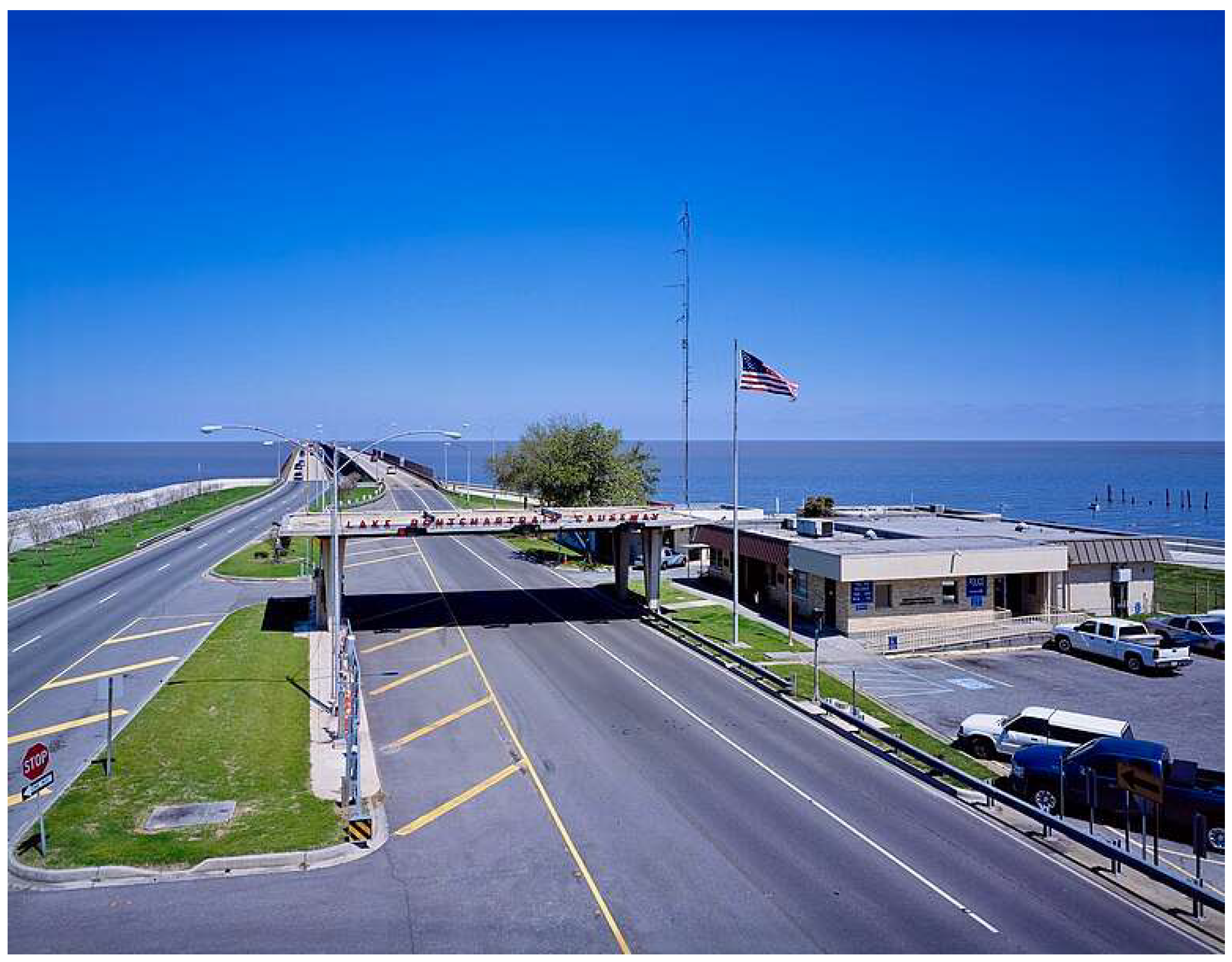
Figure 3 and
Figure 4 illustrate the bridge starters at both termini of the Lake Pontchartrain Causeway. They depict the South Lake Pontchartrain Causeway Toll Plaza in Metairie (
Figure 3) and the North Lake Pontchartrain Causeway Terminus in Mandeville (
Figure 4). These illustrate the critical continental land connections that they establish.
The Maurepas Swamp Wildlife Management Area, spanning approximately 28,300 hectares across St. Charles and St. John Baptist Parishes, represents a critical freshwater wetland ecosystem. Characterized by the Wetland Watchers Park and the 16 km Maurepas Wildlife Trail, the area serves as a pivotal site for environmental education and conservation [
26]. Historical landscape transformation of the region was initiated by French explorers Jean-Baptiste Le Moyne de Bienville and Pierre Le Moyne d’Iberville, who conducted extensive mapping of the area during the final 17th and initial 18th centuries. The establishment of Fort Maurepas in 1699 marked the initial colonial infrastructure development, accompanied by canal networks facilitating fluvial transportation and resource extraction [
27,
28]. Successive colonial administrations (French, Spanish, and American) progressively modified the wetland ecosystem. Spanish interventions included infrastructure development through the San Bernardo Mission (1779), while American acquisition in 1803 intensified natural resource exploitation and transportation infrastructure construction [
29]. Throughout the 20th century, anthropogenic interventions significantly impacted the Maurepas Swamp’s ecological integrity. Critical infrastructure projects—including the Intracoastal Waterway, Bayou Manchac, and Interstate 10—fragmented the wetland ecosystem, disrupting natural hydrological processes and habitat connectivity [
30]. These cumulative interventions have progressively degraded the Maurepas Swamp’s ecological structure, emerging from resource extraction, habitat fragmentation, urban expansion, and sediment flow alterations. Such pressures have compromised the ecosystem’s interface with Lake Pontchartrain, reducing overall ecological resilience [
31]. Contemporary conservation efforts, exemplified by the Wetland Watchers Park and Wildlife Management Area, aim to mitigate historical ecological disruptions and preserve this critical wetland ecosystem.
The Manchac Wildlife Management Area (MWMA), which encompasses 12,140 hectares in Tangipahoa Parish, is overseen by the Louisiana Department of Wildlife and Fisheries (LDWF). The area, which encompasses freshwater wetlands, marshlands, and cypress forests, serves as a vital ecological reserve. The research conducted by Visser et al. [
32] underscores the area’s rich biodiversity, while also identifying several significant challenges, including habitat degradation, the proliferation of invasive species, and the impact of climate change. In order to maintain the ecosystem’s ecological integrity and preserve its natural resources, it is necessary to implement adaptive management strategies in response to the environmental pressures that are currently being experienced [
33].
St. Tammany Parish, situated adjacent to the Tchefuncte River and encompassing both St. Tammany Refuge and Big Branch Marsh National Wildlife Refuge, serves as a prime example of intricate coastal ecosystem deterioration. The region has historically been characterized by extensive marshlands but has undergone significant urban and suburban expansion in recent decades, resulting in substantial ecological disruption. Notwithstanding the enactment of environmental regulations such as the Clean Water Act (Section 404, 1972) and the Rivers and Harbors Act (1899), a considerable number of permits have been issued for the destruction of wetlands that were not strictly necessary. The construction of urbanization projects, including developments such as Three Rivers Estates, Piney Woods, and Audubon Lake, has resulted in the systematic compromise of natural landscapes, with notable instances of wetland conversion. Specific environmental challenges include the illegal abandonment of vessels, particularly oil tanker barges used for the disposal of hazardous waste, and the unauthorized modification of wetlands. The preliminary construction works, situated in close proximity to DePaul Northshore Hospital, have resulted in the destruction of approximately 0.6 km
2 of wetland area, thereby further compromising the region’s ecological integrity [
34]. The towns of Lewisburg and Mandeville are situated within this region.
The southernmost extent of Irish Bayou is situated at the conclusion of the study area, as well as within the confines of the Parish of Orleans. In this area is located La Eden Isle, an upscale residential community with access to the lake and surrounding natural areas. This community was developed in the late 1960s and has subsequently expanded, becoming a major tourist destination. Additionally, the state’s Chef Menteur Highway (Route 90), which was originally constructed to connect New Orleans to coastal communities and ports along the Gulf of Mexico, now serves as a crucial route for accessing the St. Tammany Refuge and other natural areas in the region. The zone and study area conclude at the Bayou Sauvage Urban National Wildlife Refuge (Bayou Sauvage Urban National Wildlife Refuge), which encompasses a 93 km
2 area of freshwater and brackish marshes situated within the New Orleans city limits. This refuge is the largest urban wildlife refuge in the United States [
35].
2. Materials and Methods
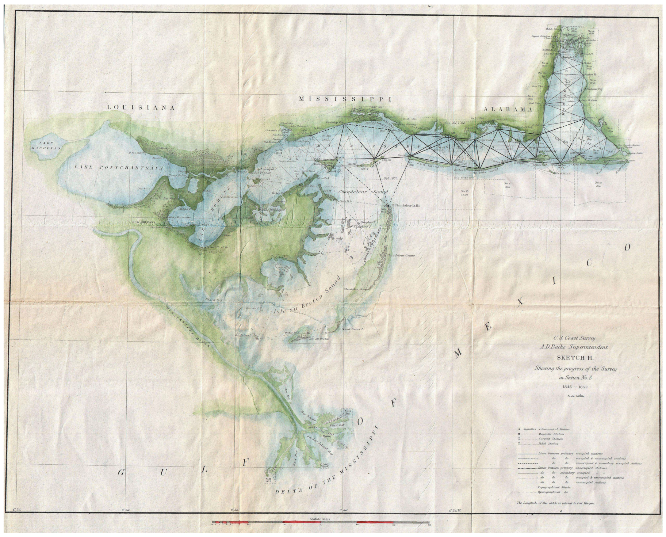
The methodology replicates previous research protocols developed by the investigative team. The methodology entails comparing two plans of the study area in order to demonstrate the alterations to the coastline and to evaluate and quantify the area situated between the two historical coastlines subjected to analysis. The case study is analyzed with reference to the map in
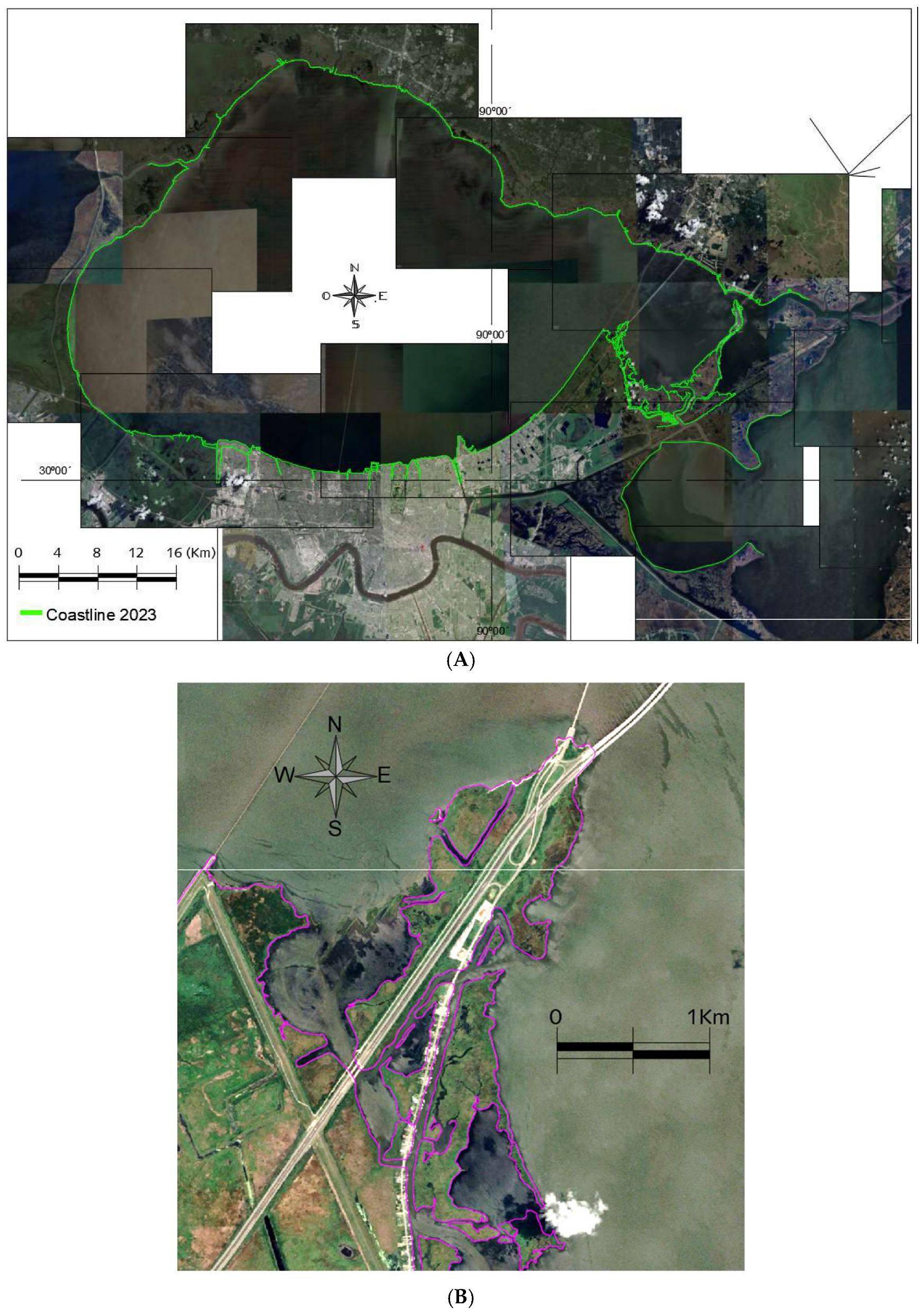
Figure 5, which corresponds to the survey in Section No. 8 from 1846 to 1852 (Sketch H). This map is taken from the 1853 edition of the Report of the Superintendent of the U.S. Coast Survey. The current coastline,
Figure 6, was generated through the photogrammetric processing of aerial images captured through the Google Earth platform, corresponding to the year 2023. These images encompass Lake Pontchartrain and the city of New Orleans.
In order to georeference the study area, the vertical coordinate information was referenced to the North American Datum 1983 (NAD 83) through the Transverse Mercator projection 15R/16R. These geodetic reference and graphic coordinate systems are based on the ellipsoid of the Geodetic Reference System, designated “World Geodetic System 1984” (WGS84).
Following vectorization, it was necessary to make a scale adjustment of the coastline obtained from the 1853 plan with a factor of 1.15 to ensure a splice that would allow comparison with the coastline obtained from Google Earth aerial photographs taken in 2023.
The accuracy and precision of the georeferencing are contingent upon the characteristics of the control points, which must, therefore, be carefully selected and appropriately characterized. In order for a control point to be suitable for georeferencing, it must satisfy the following conditions: (i) It must be “unequivocal” and clearly identifiable in the documents to be georeferenced, (ii) it must belong to accurately represented elements, (iii) it must correspond to elements that are considered “invariable” over time, and (iv) it must present a homogeneous and uniform distribution over the entire surface of the area [
36].
Spatial data were processed through a comprehensive digital cartographic transformation utilizing AutoCAD 2013, a specialized computer-aided design (CAD) software optimized for two-dimensional geometric representation. The georeferencing procedure involved exporting the geospatial reference plan from QGis v3.4.8., facilitating the systematic conversion of geographic coordinates into planar Cartesian coordinate systems, thereby enabling precise spatial data manipulation and graphical reconstruction. The vectorization process was executed with meticulous geometric precision, employing manual spatial object capture through polygonal geometry. Utilizing advanced digital zoom capabilities, vector entities were systematically aligned with raster image reference points, ensuring dimensional congruence with the original cartographic plan. Each graphical representation incorporates calibrated scale references, guaranteeing accurate spatial representation and geometric fidelity.
The vectorization methodology establishes geometric precision parameters based on digitized cartographic representations, defining the minimum detectable spatial resolution as 0.2 mm multiplied by the plan’s scale denominator. This approach leverages the average human visual discrimination threshold, constraining potential maximum positional error to 0.4 m. Coastline vector entities were systematically attributed with directional morphological indicators, where negative values signify erosional processes, and positive values represent sedimentary accretion.
Cartographic analysis entailed the superimposition of maps, a technique employed to identify substantial alterations in coastal morphology. Coastline variations were quantitatively assessed, thereby enabling precise calculation of spatial transformation zones with a methodological error margin of approximately ±5%. This methodological approach is in alignment with the established analytical standards of our research group. Coastline digitization was validated by cross-referencing satellite imagery, ground control points, and historical aerial photographs, enabling systematic identification of potential geometric distortions and spatial coordinate variations.
The selection of control points was executed with consideration for invariable and readily identifiable geographic elements across both maps, including hydrographic confluences of Lake Pontchartrain, graphic coordinates, permanent infrastructure (e.g., Martello Castle, Telegraph Ot. aux Herbes), the location of islands, and the administrative boundaries of parishes. Each control point was georeferenced with precise coordinates, ensuring their correspondence between the historical map of 1853 and the satellite image of 2023, with a maximum positioning error of ±0.5 m. This process ensured the reliability of the georeferencing process and minimized potential cartographic distortions. The scale setting of 1.15 guarantees that the two coastlines under scrutiny align at each of the specified control points.
The research methodology integrates physical environment perception and historical coastal landscape evolution as a critical interpretative framework. By establishing a rigorous protocol, the study provides a comprehensive geographical-historical analysis that transcends the limitations of mere description. It offers a holistic interpretative approach to understanding landscape dynamics. This methodological strategy integrates spatial, temporal, and analytical dimensions with academic precision.
3. Results
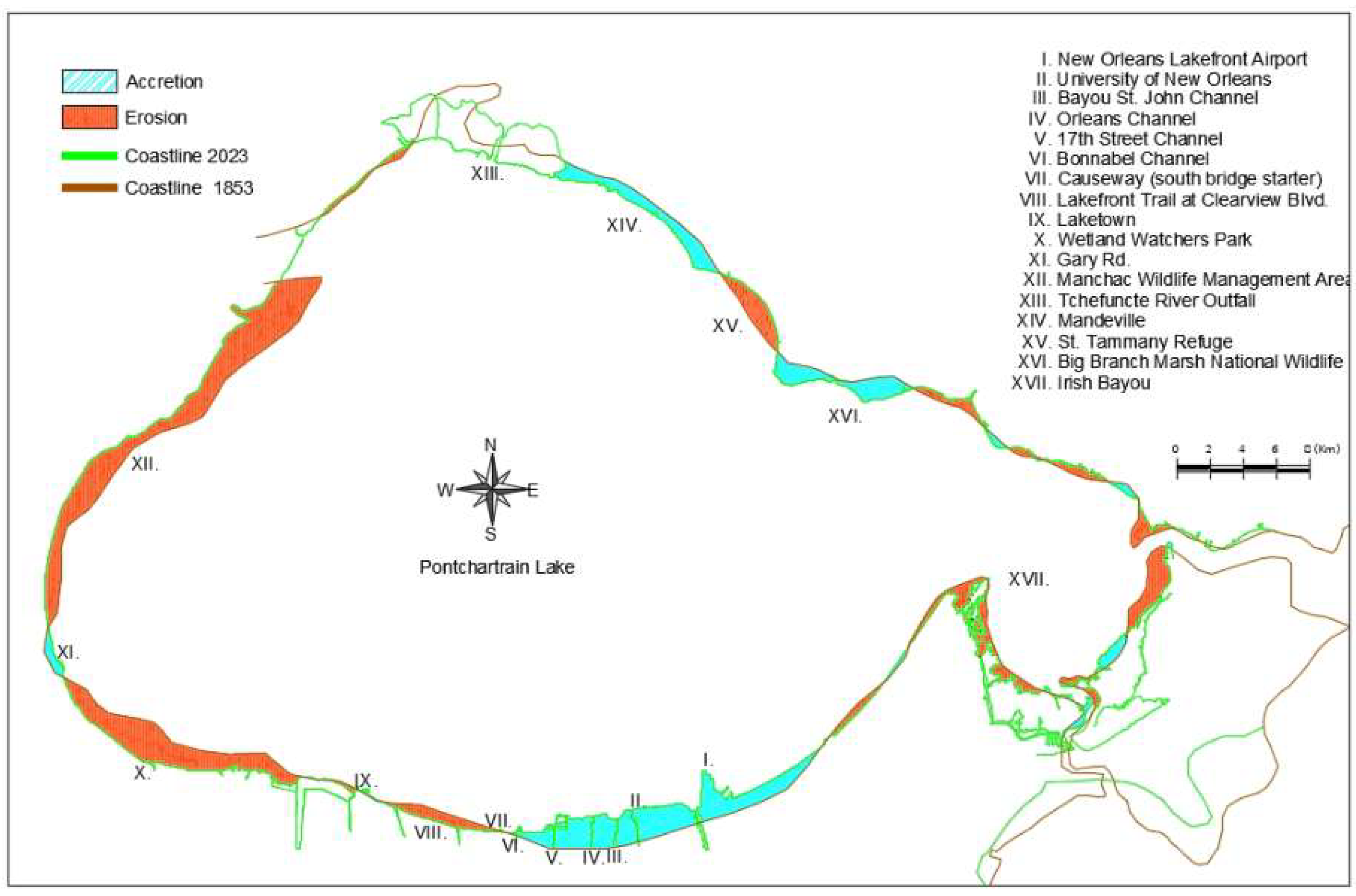
Initial coastline analysis compared colonial-era (1853) and contemporary (2023) geospatial representations. Due to inherent cartographic discontinuities, the 2023 Google Earth coastline served as the primary reference template. The 1853 coastline was systematically scaled by a factor of 1.15 and segmented into three discrete sections to optimize geometric alignment. Optimal overlay techniques facilitated precise comparative analysis, revealing a net erosional transformation affecting 36.42 km2 of the study area.
Figure 7 shows the overlay that best fitted the two vectorized lines.
Table 2 presents the areas of accretion or erosion observed in each section, along with the final quantification.
The quantification of error margins was achieved through systematic cross-validation of geospatial datasets from the United States Geological Survey (USGS) and the Environmental Protection Agency (EPA). These datasets were obtained from the University of New Orleans. The open web page where these datasets can be found is as follows:
https://pubs.usgs.gov/of/2002/of02-206/env-issues/change-rate-npon.html, accessed on 19 August 2024)
The aforementioned data were obtained according to the following description, which can be found on the website: “Shorelines compiled in database were derived from either topographic or near-vertical aerial surveys conducted between 1850 and 1995. The high-water line is used as the official shoreline on cartographic data and is interpreted and determined on near-vertical aerial photographs according to the location of the wet and dry beach contact or the high-water line. To evaluate change in shoreline position, shore-normal transects were constructed at approximately two-minute intervals of longitude or latitude and used to measure the change in location of two corresponding shorelines in different years. Average rates of movement were calculated by dividing absolute measurement by elapsed time”.
The coastal erosion resulting from the analysis of data from the USGS and EPA totals 38.05 km2. Consequently, the margin of error for the data in this case study is approximately ±4.28%.
The study was conducted in a clockwise direction, beginning with the coast of New Orleans and subsequently traversing the interior of Pontchartrain Lake. The analysis encompassed a comprehensive examination of the shorelines. The study concluded with an analysis of the coastal area of Irish Bayou, located in the eastern end of Orleans Parish. The following section will present a detailed account of the results obtained for each zone.
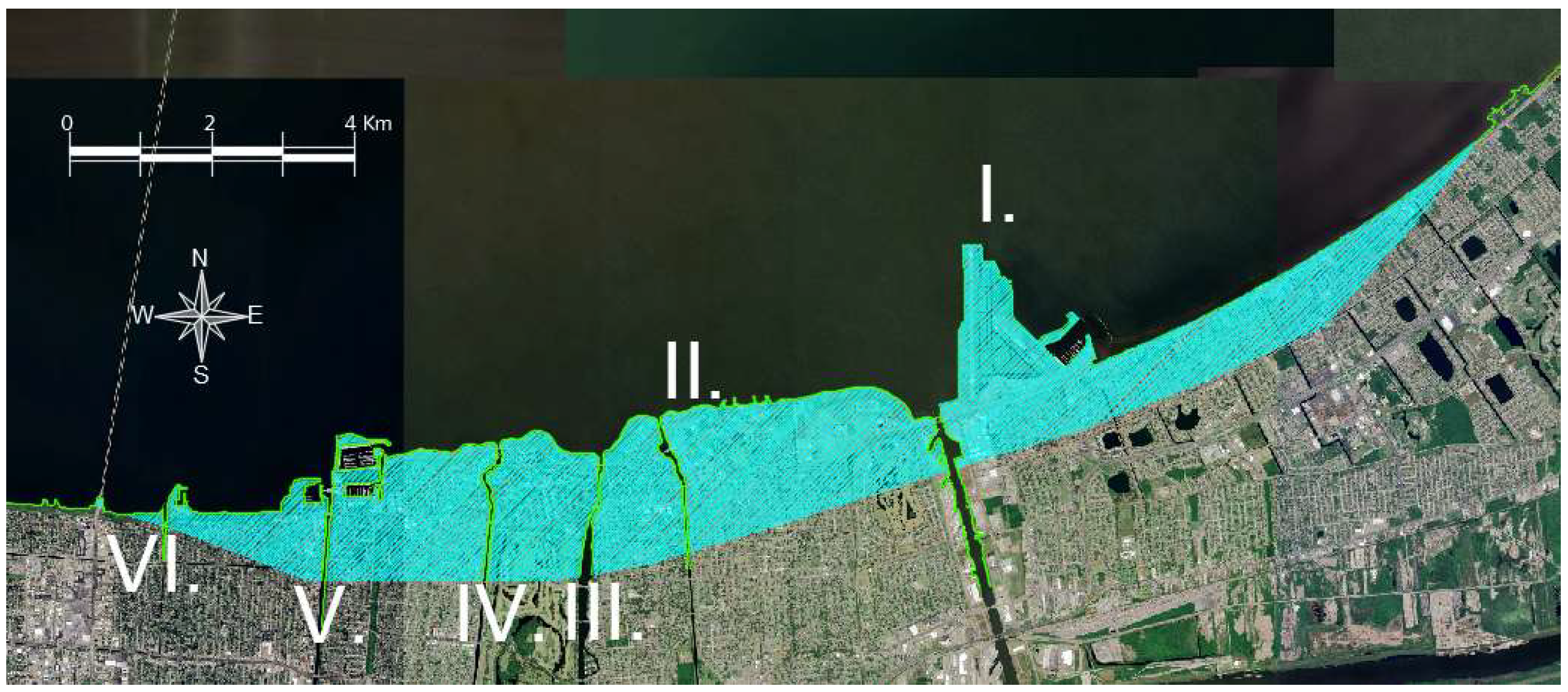
The coastal zones I to VII, evidencing 24.03 km2 of land reclamation from the lake, correspond to the New Orleans coastline and primarily comprise critical infrastructural developments: I. New Orleans Lakefront Airport, II. University of New Orleans, III. Bayou St. John Mouth, IV. Orleans Channel Mouth, V. 17th Street Channel Mouth, VI. Bonnabel Channel Mouth, and VII. Causeway (Southern Bridge Terminus). These structures have been progressively modified to function as adaptive protective infrastructures capable of mitigating storm surge, hurricane impacts, and sea-level rise. Lakefront Airport (Zone I) was constructed through hydraulic fill techniques to elevate terrain above sea level. Zones II to VII, encompassing various canal and natural waterway mouths transporting water from the city’s interior to the lake, have been integral to comprehensive drainage and flood containment strategies, involving reinforcement, landfill, and morphological modifications to ensure robust urban protection. These interventions represent a critical approach to urban resilience and coastal management in a dynamic environmental context.
Zones VIII to XII have demonstrated a significant erosion of 57.64 km2, representing over 75% of the total study area erosion. The Maurepas Swamp region has experienced substantial surface area loss in recent decades, driven by complex, interconnected environmental and anthropogenic factors. Soil subsidence, caused by drainage, groundwater extraction, and compaction, has progressively transformed wetlands into open water bodies, while accelerated sea-level rise in the Gulf of Mexico has systematically inundated coastal ecosystems. Catastrophic hurricanes such as Katrina and Rita have inflicted severe damage through cyclonic storm surges and high-velocity winds, causing extensive vegetation destruction. Concurrent human activities, including infrastructure construction, pollution, and urban development, have further fragmented and degraded these critical ecological systems. The synergistic interaction of these natural and anthropogenic processes has resulted in a concerning and accelerated surface area reduction in the Maurepas Swamp, highlighting the urgent need for comprehensive coastal restoration and management strategies.
Zone XIII, corresponding to the Tchefuncte River Mouth, presents a complex coastal morphology that defies conventional accretion or erosion calculations. The 1853 historical map reveals a significant water inlet with a double coastline, while the 2023 landscape exhibits artificial lakes and predominantly water-covered wetlands, rendering comparable coastline delineation impossible. This zone encompasses the Southeast Madisonville/Mandeville Marsh, a critical saltwater coastal wetland classified as a marsh ecosystem, strategically located southeast of Madisonville and Mandeville in St. Tammany Parish. The marsh is characterized by typical coastal marsh vegetation, including reeds, spartina, and mangroves, which function as a natural buffer against flooding and storm events, providing essential ecological protection for adjacent communities. The complex hydrological and vegetative characteristics of this zone underscore the dynamic nature of coastal wetland systems and their critical role in regional environmental resilience.
Zone XIV, encompassing the Lewisburg Community, Mandeville City, and Fontainebleau State Park, demonstrates a notable land accretion of 7.82 km2. The area’s coastal transformation was predominantly driven by anthropogenic interventions during the late 19th and 20th centuries. The construction of hotels, summer residences, and the municipal pier in the second half of the 19th century, followed by extensive residential and commercial neighborhood developments throughout the 20th century, significantly altered the coastal landscape. A pivotal infrastructure project, the Causeway’s northern section constructed in 1956, not only catalyzed urban development but also facilitated substantial artificial land reclamation through hydraulic fill techniques. These strategic interventions effectively expanded the urban footprint by incrementally gaining terrain from Lake Pontchartrain, representing a deliberate and systematic approach to urban expansion and coastal modification.
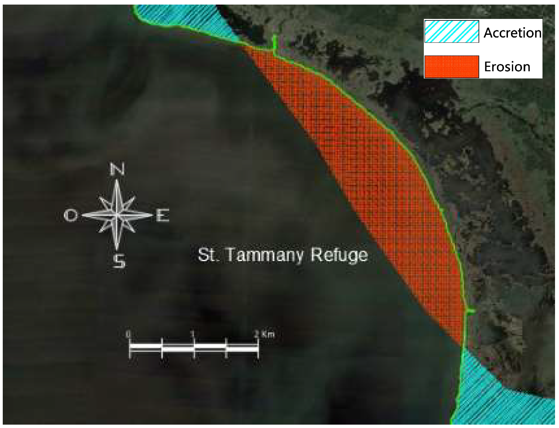
Zone XV, corresponding to the St. Tammany Refuge, exhibits coastal erosion of 4.63 km2 within a protected area, spanning approximately 19,400 hectares of diverse ecological landscapes, including wetlands, swamps, forests, and prairies. The complex vegetative composition renders the area vulnerable to multifaceted erosional processes driven by urban and agricultural development, alongside extractive industries such as petroleum, natural gas, and mining operations. These anthropogenic interventions have systematically compromised habitat integrity, resulting in significant ecological fragmentation and degradation. Compounding these challenges, recurrent hurricane events and flooding patterns have progressively eroded and destabilized the refuge’s wetland and swamp ecosystems. The synergistic interaction between human-induced landscape modifications and extreme climatic events underscores the critical vulnerability of coastal ecological systems to persistent environmental pressures.
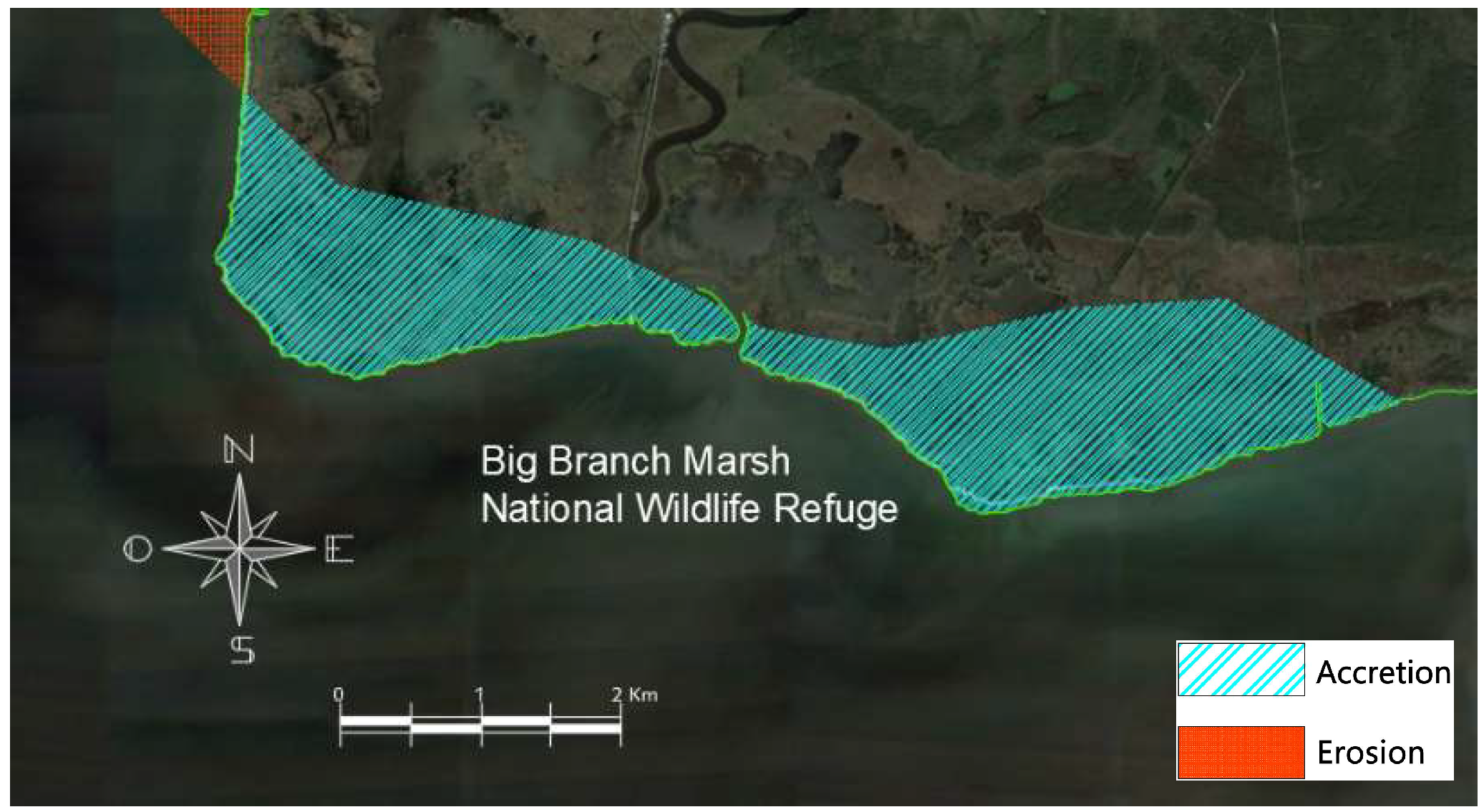
Zone XVI, the Big Branch Marsh National Wildlife Refuge, situated adjacently to the St. Tammany Refuge (Zone XV), encompasses approximately 7300 hectares of ecologically diverse terrain, including wetlands, swamps, and forests. The current study reveals a land accretion of 5.43 km2 within this critical ecological zone.
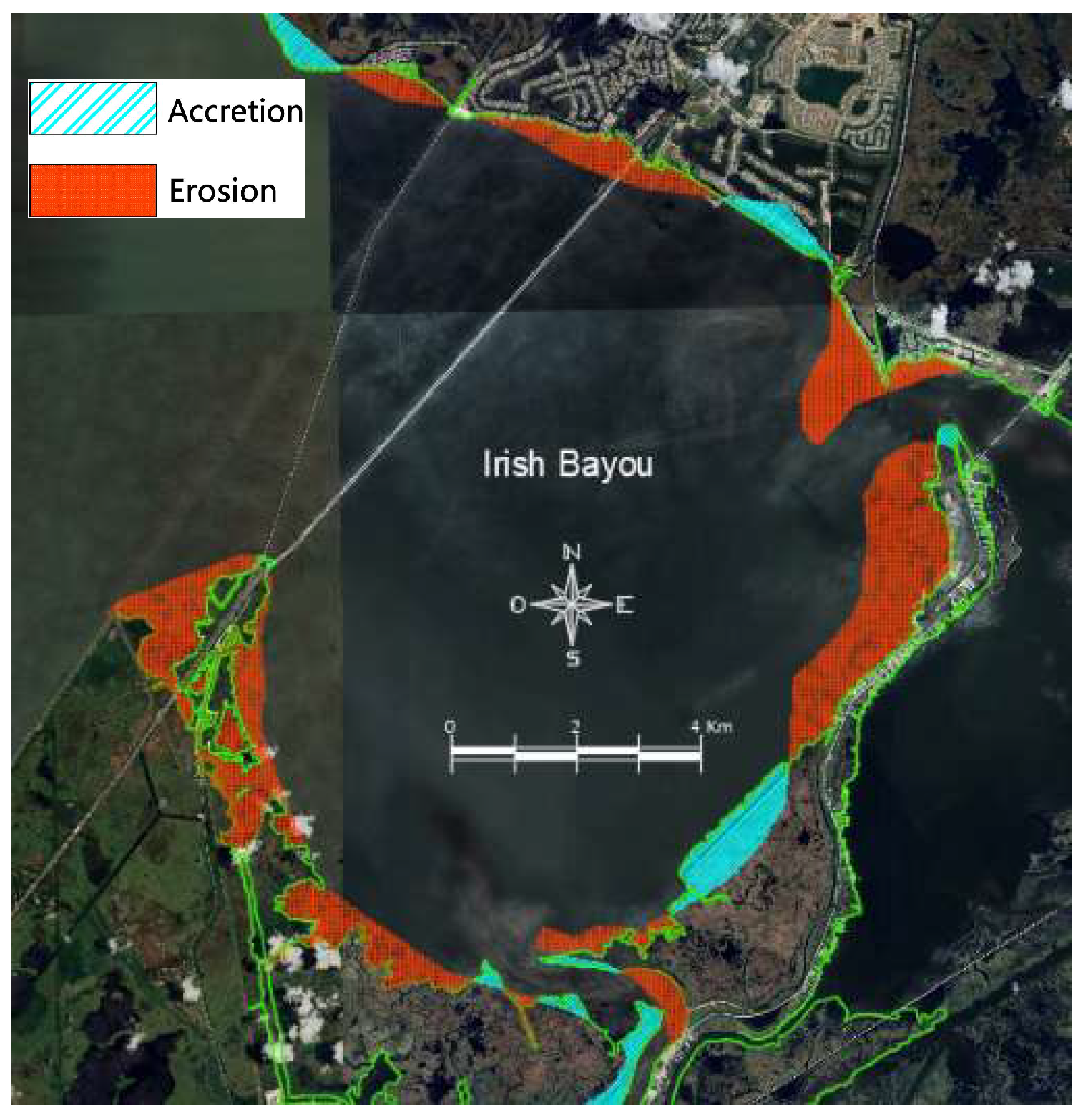
Zone XVII, encompassing the Irish Bayou, reveals a complex coastal morphology across approximately 80 km, characterized by interspersed erosion and accretion zones, resulting in a net erosion of 12.85 km2. As a critical access point between the Gulf of Mexico and the lake, this area has been significantly impacted by saltwater intrusion and hurricane-force winds throughout its historical development. The construction of communication bridges and residential communities has simultaneously contributed to land reclamation from surrounding water bodies, demonstrating the dynamic interaction between anthropogenic infrastructure and coastal landscape transformation.
4. Discussion
The study’s findings were analyzed in light of previous research conducted in the relevant field of study. Despite the limitations of comparative assessments in precisely determining coastal accretion and erosion zones, they enabled an evaluation of coastal dynamic behavior, including variations in geomorphology, vegetation, granulometry, and other relevant factors. The bibliographic references corroborate the alignment between the identified accretion or erosion areas and the historical development of each zone. The presented evidence illustrates the considerable influence of human activities on the coastal landscape, exemplifying the intrinsic variability inherent to coastal systems.
Zones I to VII correspond to the New Orleans coastline along Lake Pontchartrain. The Lakefront Airport (Zone I), originally named Abraham Lazar Shushan, was constructed between 1929 and 1933 by the architectural firm Weiss, Dreyfous & Seiferth. The airport was constructed on an artificial peninsula reclaimed from the lake through the Lakefront Improvement Project and inaugurated on 2 September 1934 (
Figure 8 and
Figure 9). The construction of the airport necessitated the erection of a 3048 m (10,000-foot) containment wall in Lake Pontchartrain and the pumping of six million cubic yards (approximately 4,587,330 m
3) of hydraulic fill to elevate the field above water. The airport was forced to close due to Hurricane Katrina until October 2005, when it reopened. During this period, the interior of the airport flooded to a depth of over 1.2 m, while the exterior was inundated by up to 2.4 m of water. Between 2008 and 2013, the airport underwent a period of renovation and restoration, with the aim of returning it to its original architectural form [
37,
38]. The latest research findings suggest that the land area has increased by 7.88 km
2.
The Lakefront Improvement Project, which was carried out between the years 1926 and 1934, entailed the construction of a dike situated between 914 and 1219 m from the shoreline of the lake. The terrain situated between the dike and the 1926 coastline was subject to dredging and the gradual introduction of hydraulic fill. The dredging and filling process, which spanned a period of over three years, resulted in the accretion of 8.1 km
2 (2000 acres) of land, with an elevation between 1.2 and 1.8 m (4 and 6 feet) above the lake level and approximately 3 m (10 feet) above the subsiding Lakeview and Gentilly lowlands. The construction of the stepped concrete dike was completed in 1930. Upon the conclusion of the project in 1934, the newly constructed neighborhoods, including Lake Vista, Lakeshore, Lake Terrace, and Lake Oaks, which were primarily developed in the post-World War II era, were established on both the reclaimed lands and the sites of historical riverside communities, namely Port Pontchartrain and Old Milneburg [
39]. The project also had an impact on the Spanish Fort community, situated at the confluence of Bayou St. John and the Old Basin Canal, as well as the West End area along the New Basin Canal. The construction of the project led to the formation of land on the eastern side of the West End, which was subsequently transformed into a harbor in 1938.
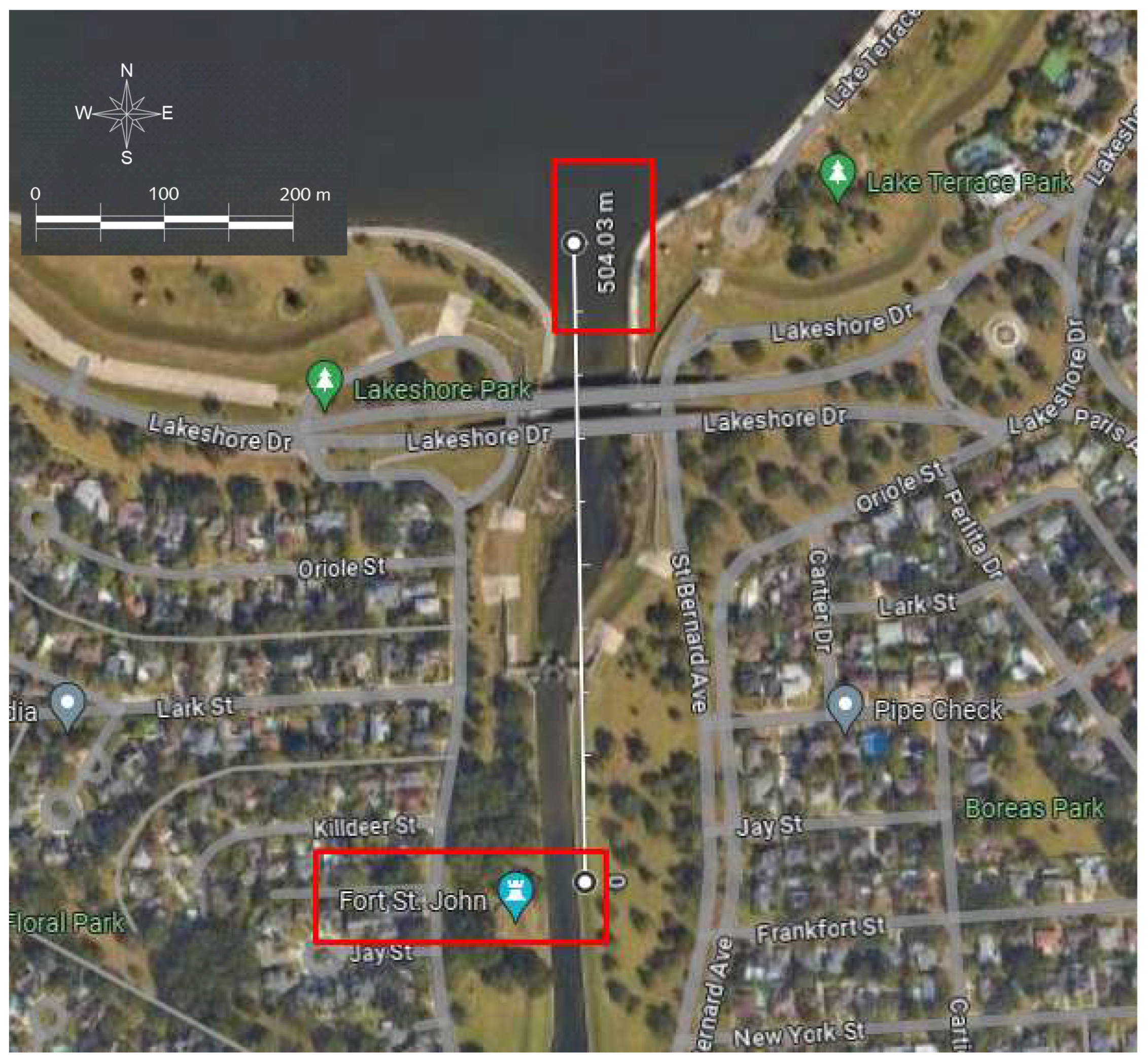
As has been previously outlined, the areas designated as zones II to VII encompass a variety of canals and natural streams. The Bayou St. John Canal, en route to the lake, traverses the ruins of the Bayou Saint John Fort, an edifice that was originally situated at the mouth of Bayou Saint John in Lake Pontchartrain (18th century). The remnants of the fort are currently visible in the area designated as Spanish Fort, a historic park in New Orleans, situated approximately 500 m from the mouth of the canal. This location demonstrates the accretion that has occurred in the region (
Figure 10). Prior to Hurricane Katrina, maintenance and reconstruction work was required on the 17th Street Canal. One such instance was the deterioration of the concrete walls observed during inspections conducted between 1980 and 1981. Following various approaches to a solution, a steel-sheet pile retaining wall was constructed between 1992 and 1993 to support the concrete walls at the crest of the levee [
20].
A review of historical records reveals a series of projects and minor works of repair, reinforcement, modification, and new construction within the dikes of the drainage channels and the dikes in front of the lake. These efforts were undertaken with the objective of safeguarding the city [
19]. Following the completion of the analysis and a comparison of the results with those of previous research, it can be concluded that the 16.15 km
2 of accretion obtained during this research is in accordance with the historical development of these areas.
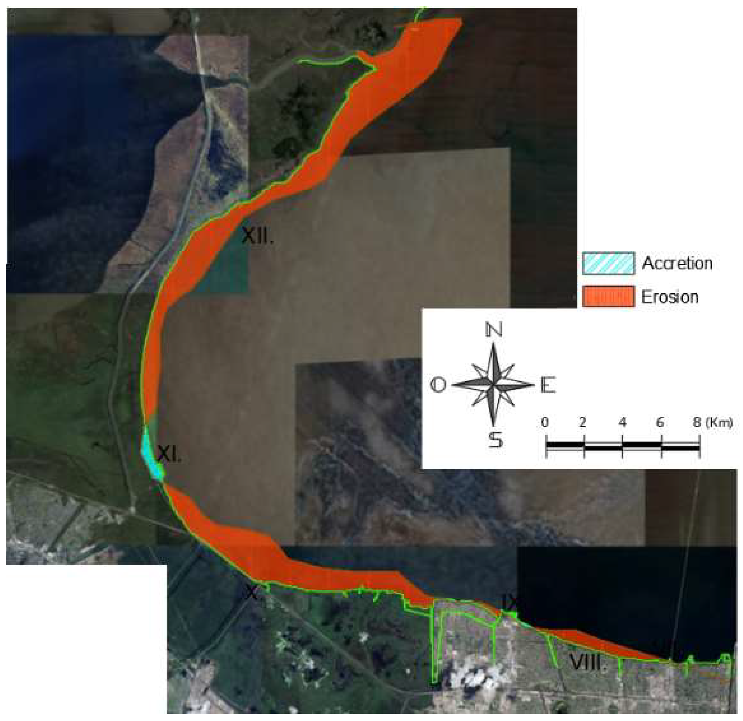
Zones VIII to XII (
Figure 11), spanning from Maurepas Swamp to Manchac Wildlife Management Area, have experienced significant land loss historically. According to Krauss [
40], the swamp has dramatically diminished, with only 30% maintaining a closed forest canopy, 58% in transition, and 12% existing as severely degraded open wetlands. Primary land loss originates from increased water salinity, critically impacting freshwater ecosystems dominated by bald cypress and water tupelo, which are extremely sensitive to saline intrusion. The PO-29: River Reintroduction into Maurepas Swamp project aims to reintroduce Mississippi River water to maintain annual salinity below critical ecological thresholds [
26]. Erosion is multifactorial, associated with residential, commercial, and agricultural expansion, wetland drainage, and land-use transformations that fundamentally alter ecosystem dynamics. Couvillion et al. [
30] demonstrated that episodic events like hurricanes significantly contribute to coastal land loss. Annual erosion rates increased from −30.46 km
2/year (1985–2004) to −42.92 km
2/year (1985–2010), reflecting an accelerated land loss trend. Hurricanes induce complex ecological stress through elevated salinity and sulfur levels, potentially triggering long-term vegetation degradation. Steyer et al. [
41] highlighted a critical phenomenon where storm impacts are not immediately visible but manifest consistently months after the event. The research revealed that storm-induced stress contributes to observed land losses, with some areas showing delayed ecological deterioration. This comprehensive analysis aligns with previous studies by Barras et al. [
31], confirming the research group’s finding of 57.64 km
2 erosion as a faithful representation of swamp, wetland, and vegetation loss in the described zones. The results underscore the complex, interconnected nature of coastal ecosystem transformation, driven by both natural and anthropogenic processes.
Anthropogenic intervention in the Maurepas sub-basin’s hydrogeological system, initiated in the mid-19th century, has catalyzed critical ecosystem transformation through structural modifications disrupting natural processes: Mississippi River levee construction (post-1927 flood events) and canal excavation for navigation and resource extraction have hydraulically decoupled the system, obstructing freshwater, sediment, and nutrient flows, thereby inducing saline intrusion, degradation of Taxodium distichum and Nyssa aquatica forest stands, and accelerated tree mortality; technical projections indicate that, in the absence of immediate engineering mitigation, approximately 75% of forested wetlands will transition to marshlands or open water bodies before 2050, exponentially escalating the geomorphological and ecological vulnerability of adjacent communities to extreme meteorological events.
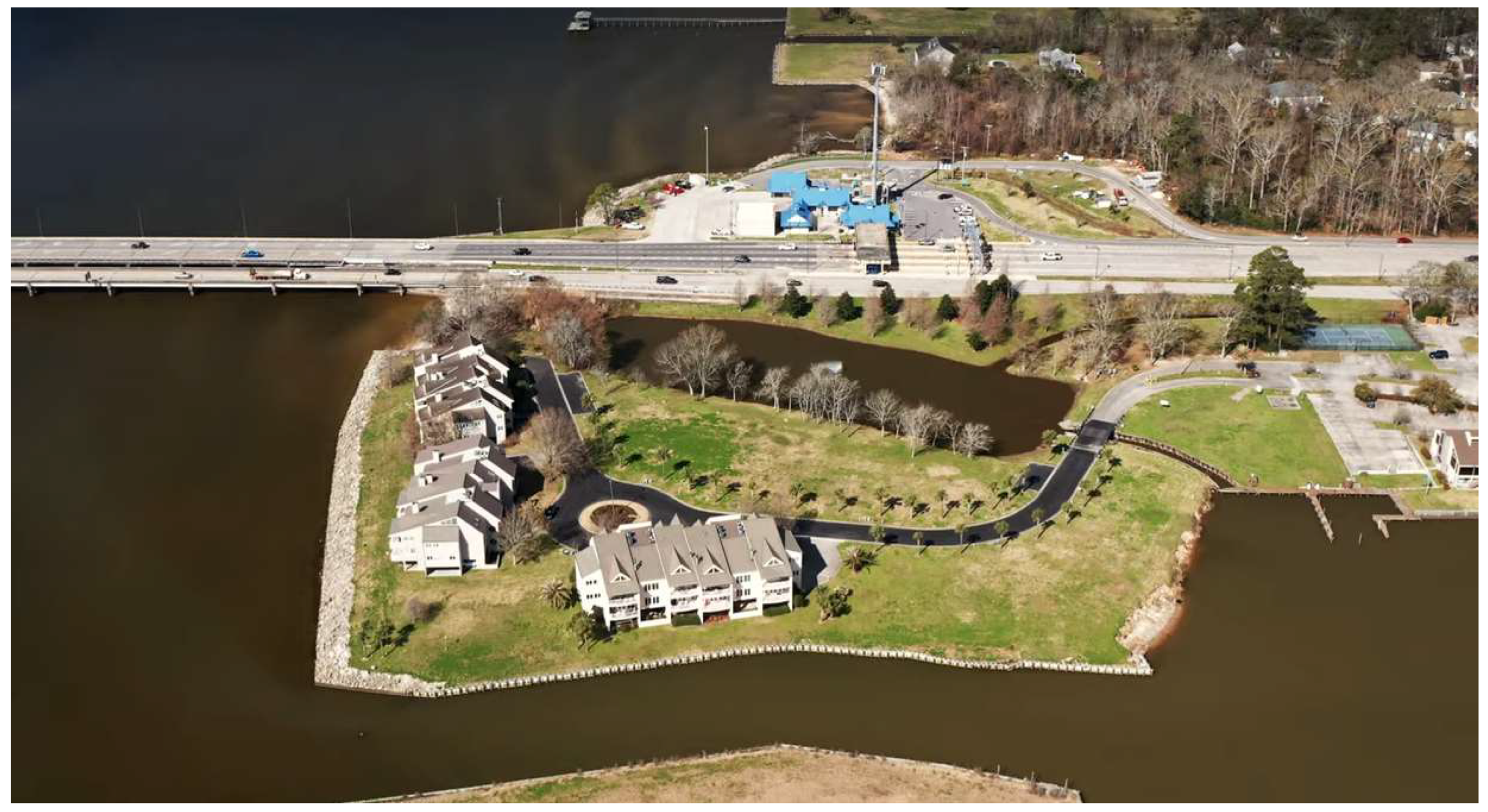
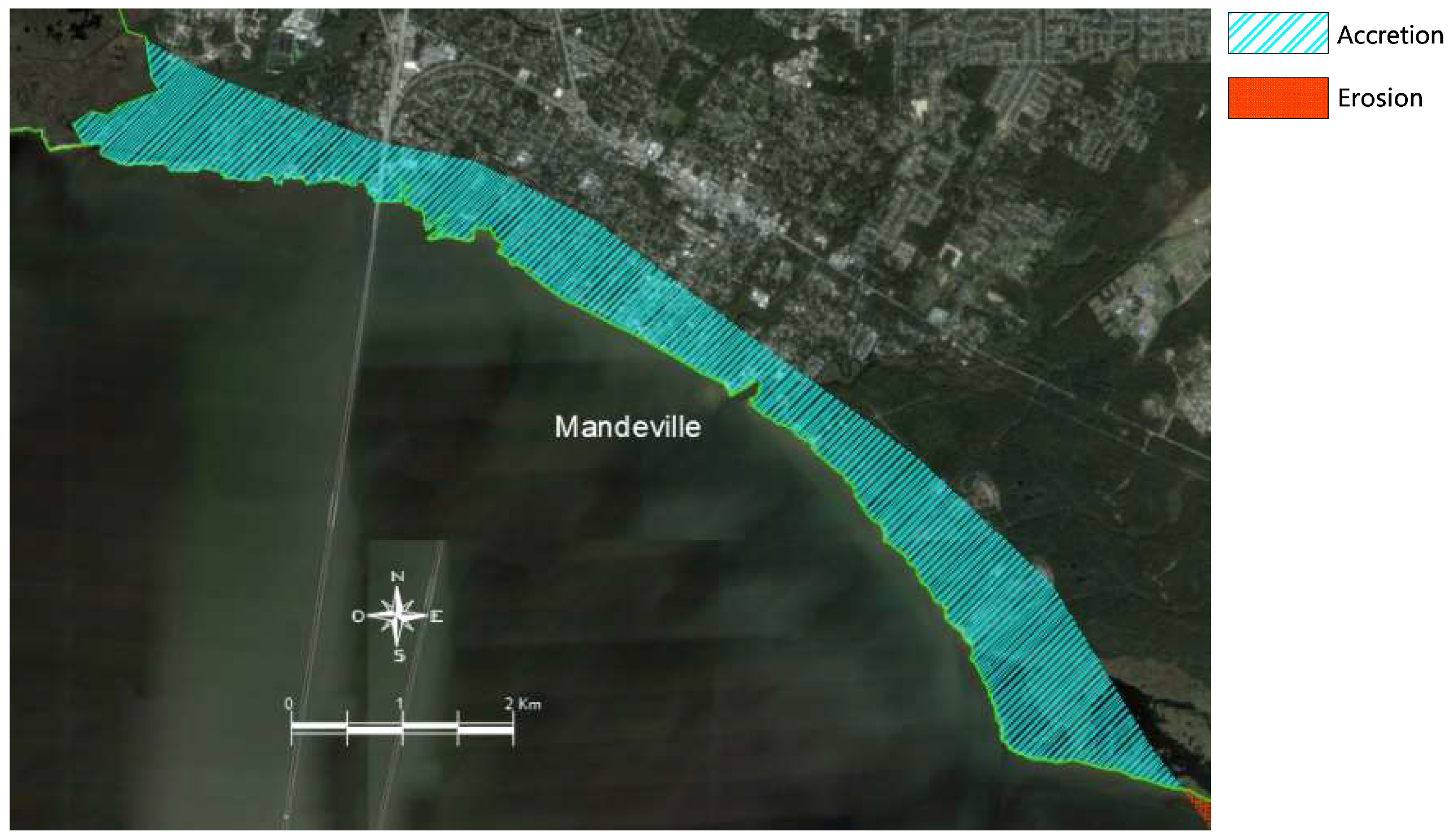
Zona XIV Mandeville (
Figure 12), Comunidad Lewisburg y parque estatal Fontainebleau. Mandeville is situated on an elevated platform formed during the last glacial era along the northern coast of Lake Pontchartrain. The town spans 2.5 km of temperate lakefront. The landscape is characterized by a diverse array of vegetation, including oak, magnolia, cypress, and pine trees, with the primary waterways being Bayou Chinchuba, Bayou Castine, and Ravine aux Coquilles. Since the late 19th century, urban planning has employed a series of strategic guidelines to preserve high-quality built environments. These include the provision of spacious lots, building setbacks, controlled residential and commercial densities, and a 35-foot height limit, which is designed to maintain tree canopy dominance. The Mandeville Lakefront Project of 1834, initiated by Jean Bernard de Mandeville, resulted in the creation of a two-kilometer passive park through the implementation of a protection agreement. During its golden era (1870–1930), the area was characterized by the presence of numerous private and public piers, steamboat traffic, an electric railway, and bathhouses. Presently, the only remaining structures are the reconstructed lookout and fountain. Lewisburg, a community established in the 1770s between Bayou Castine and the Tchefuncte River, acquired its current name in 1833 when Joshua Lewis’s heirs christened the parcel in his honor. The Parks and Greenways Commission has continued to adopt landscaping standards with the objective of protecting existing vegetation and requiring the replacement of lost trees [
42].
Ellis [
43] posits that in 1862, as a consequence of the Civil War, all docks and wharves were burned with the intention of impeding the approach of the Union ship and its soldiers. In 1880, the Poitevent and Favre sawmill was established in Lewisburg, situated in close proximity to the present-day Lake Pontchartrain Causeway, specifically in the area that is currently located just off the north toll plaza. The construction of the Lake Pontchartrain Causeway commenced in two phases in 1956. The initial phase of construction, which spanned from 1956 to 1958, entailed the erection of the inaugural section of the two-lane bridge, which measured 24 km (or 15 miles) in length. In the second phase (1966–1969), the bridge was widened due to an increase in traffic by the addition of a second parallel section [
44]. The disparate historical sources pertaining to the region indicate that the 7.82 km
2 accretion value is an appropriate estimation.
Zone XV St. Tammany Wildlife Refuge (
Figure 13), located in St. Tammany Parish. This wildlife refuge originated from a 1938 state acquisition of Great Southern Lumber Company lands. Comprising 5.3 km
2 of the original purchase, the area has experienced significant coastal erosion [
45]. Detailed spatial analysis confirms a 4.63 km
2 shoreline transformation, aligning with previous ecological surveys and demonstrating the persistent morphological dynamics induced by Lake Pontchartrain’s hydrological processes.
The present study yielded an accretion value of 5.43 km
2 in Zone XVI of the Big Branch Marsh National Wildlife Refuge (
Figure 14). This favorable result may be attributed to the reconstruction projects and works carried out in the aftermath of Hurricane Katrina in 2005. These include the reconstruction of the Boy Scout Road Trail boardwalk in 2007, the replanting of trees in the refuge during 2006–2007 and the restoration of the marsh in the refuge [
46]. The Fish and Wildlife Service (2007) also undertook marsh restoration in the Goose Point and Point Platte areas in 2008. This involved the installation of tree fences in certain areas of the marsh, which serve to reduce wave action, trap sediment, and combat erosion [
47].
The last area, XVII Irish Bayou (
Figure 15), shows erosion of its 12.85 km
2 shoreline. However, there are small sections in the area where the result has been favorable, i.e., accretion. Since Hurricane Katrina destroyed part of the study area, improvement and prevention plans and projects have been implemented. Most recently, as described by Bollfrass in 2022 [
48], the Bayou Sauvage Marsh Creation project involves the installation of over 3000 m (10,000 linear feet) of articulated concrete mats along the shoreline of Lake Pontchartrain to form hurricane protection levees in eastern New Orleans. Material was hydraulically dredged from Lake Pontchartrain to create 0.8 km
2 (200 acres) of marsh and nourish 0.04 km
2 (10 acres) of broken marsh, for a total benefit of between 0.8 and 1.0 km
2 (200–250 acres) at the end of implementation. The history of post-Katrina protection efforts and future plans show that the area has been severely impacted, and the erosion results from this research group are consistent. The study by the Coalition to Restore Coastal Louisiana [
49] shows that as wetlands and barrier islands are lost, even areas once considered safe, such as Irish Bay, become more vulnerable to flooding and storm damage.
The political-engineering intervention dynamics in the Irish Bayou hydrogeological system reveal a multifactorial strategy for saltwater intrusion mitigation. This strategy is grounded in the Lake Pontchartrain Basin Foundation’s Comprehensive Management Plan (CMP), integrating ecosystem restoration methodologies and hydraulic control. The implementation of this strategy is derived from the Lake Pontchartrain Basin Restoration Act (2000). The SAVE OUR LAKE campaign, a successful initiative, successfully removed the lake from the impaired water bodies category in 2006. This was achieved through interventions addressing critical vectors such as urban runoff, wetland degradation, and obsolete hydraulic infrastructure, with federal investment recognizing the complexity of Louisiana coastal systems. However, significant challenges persist in implementing predictive tools and proactive mitigation strategies [
50].
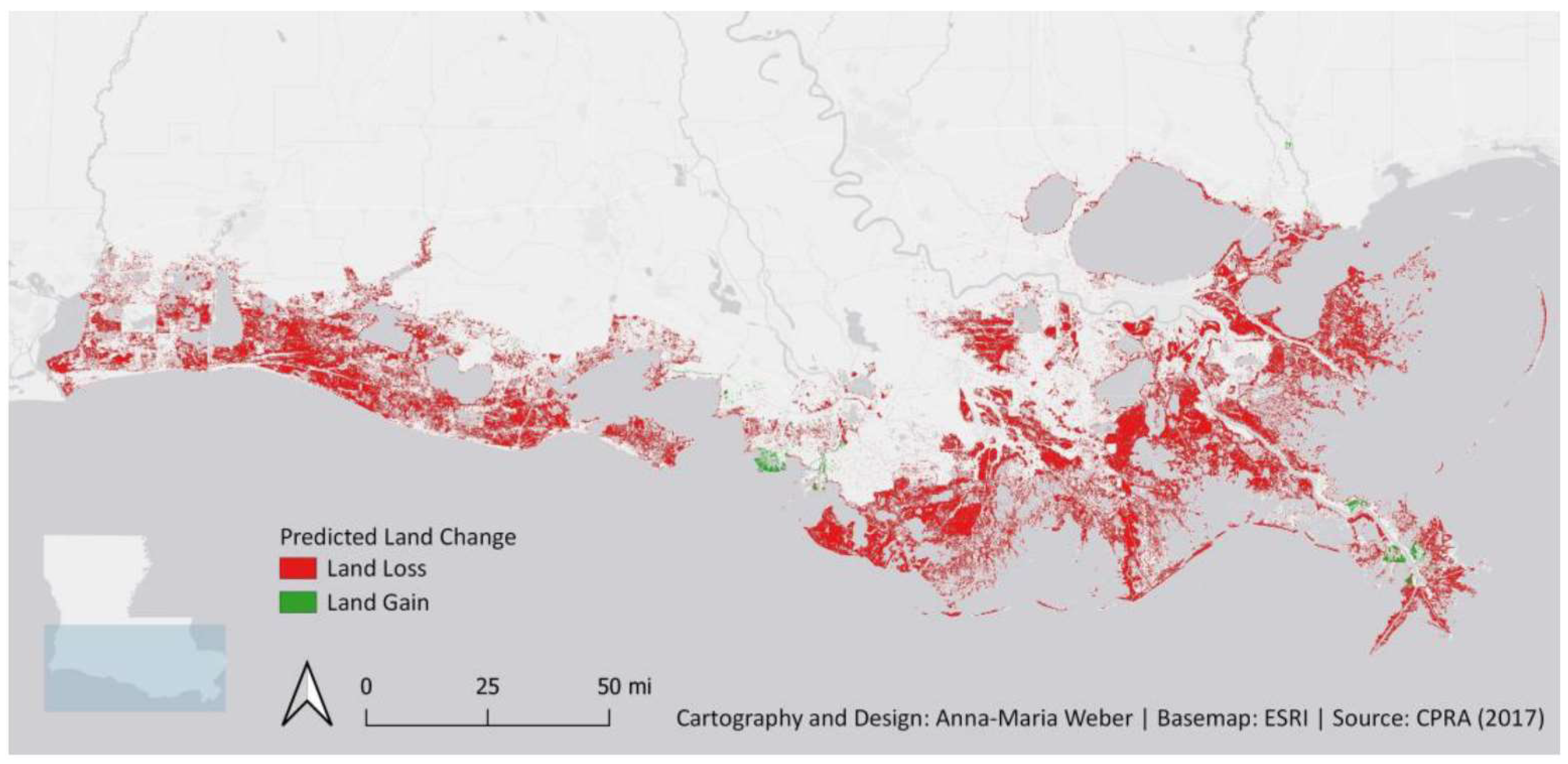
The 2017 Coastal Protection and Restoration Authority projection [
51] illustrates anticipated coastal morphological changes over the subsequent five decades under an intermediate environmental scenario. Cartographic representations delineate potential land loss (red) and accretion (green) zones (
Figure 16). The Coastal Master Plan strategically proposes mitigation interventions for Lake Pontchartrain shoreline communities, including Slidell, Lacombe, Mandeville, Madisonville, and Ruddock, integrating structural and non-structural risk reduction strategies.
Figure 17 illustrates the diverse types of coastlines present within the study area, which encompass natural levees, uplands, marshes, swamps, mudflats, and urbanized land.
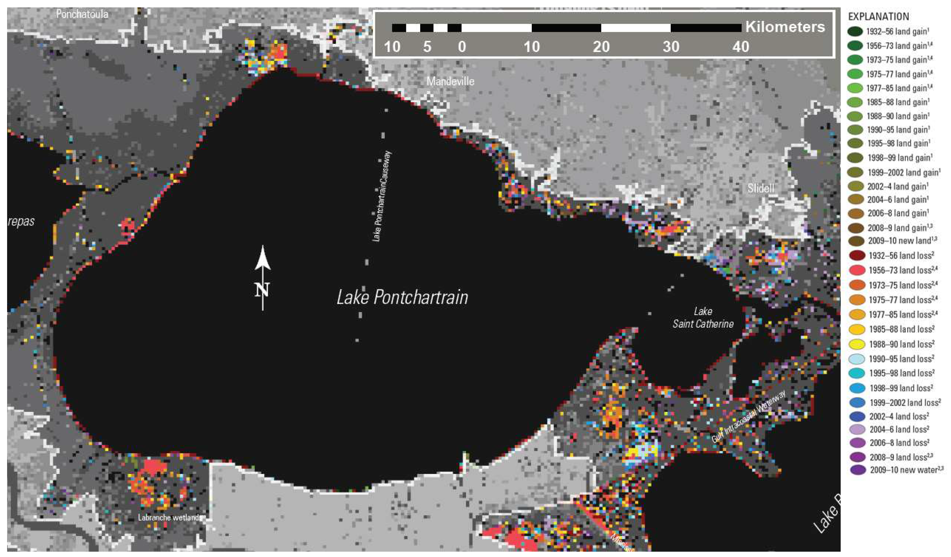
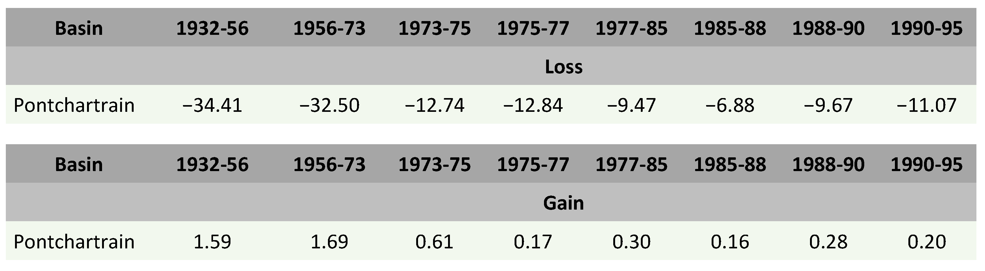
Figure 18 illustrates the findings of the research conducted by Couvillion et al. in 2011 [
30], which delineated the study area. On the right side of the image, the years and the final result in terms of erosion or accretion are indicated. A comparison of these results with those obtained in the present research reveals a clear association between the areas exhibiting erosion and the type of coastline depicted in
Figure 17. Of the coastlines in question, those composed of vegetation appear to be the most susceptible to erosion.
A comparison of the results obtained for this case study with those of previous research reveals a high degree of concordance between the two. This concordance is evident both in terms of the historical factors that have shaped the coastal landscape and in regard to the quantitative results of previous research.
Figure 19 below illustrates the findings of Couvillion et al. (2011) [
30], which demonstrate that erosion in the study area is significantly greater than the accretion observed.
The findings of the Coastal Protection and Restoration Authority of Louisiana in 2017 [
51] indicate that, in the absence of adherence to the proposed plan, coastal Louisiana is at risk of losing between 2118 and 4677 km
2 of land over the next 50 years. Conversely, the implementation of the protection and restoration projects outlined in the Master Plan has the potential to mitigate between 40% and 75% of this projected loss. The long-term maintenance of project effects has been most effectively achieved in areas exhibiting low rates of sea-level rise and subsidence, with a reliable source of sediment to support the natural accretion of marshlands.
5. Conclusions
The integration of the current findings with previous information available in the scientific literature enriches the understanding of the behavior and dynamics of the coastline in the study area, contributing to a more complete and informed vision of the analyzed phenomenon.
The research provides a comprehensive historical examination of coastal landscape transformation driven by anthropogenic interventions. Although the study does not explicitly analyze socioeconomic implications, it critically illuminates the long-term environmental consequences resulting from governmental and social decision-making processes. The investigation reveals how historical actions and policies fundamentally reshape coastal ecosystems, generating persistent environmental and potential socioeconomic repercussions.
The findings of the present study were contextualized within the existing body of research on the subject matter, thereby substantiating the hypothesis that the identified areas of accretion or erosion are consistent with the historical evolution of each specific zone. This evidence substantiates the assertion that human activities have exerted a significant influence on the coastal landscape.
The identified accretion areas are associated with infill projects, infrastructure construction and urban development. In contrast, the erosion areas are linked to natural processes, including subsidence, sea level rise and the impact of hurricanes, as well as human activities such as wetland fragmentation and degradation.
The investigation of this third case study reveals a significant and concerning loss of area, amounting to 75.12 km2, which is predominantly situated within the wetland and swamp ecosystems of the region. In addition to the factors described in the preceding paragraph, it is evident that human activities, including infrastructure construction, pollution, and urban development, have further fragmented and degraded the ecosystems.
The research findings reveal a profound transformation of the Lake Pontchartrain coastal landscape, demonstrating that anthropogenic interventions have systematically altered ecosystem structures, resulting in substantial modifications to wetland, marsh, and forest environments. These changes underscore the critical vulnerability of coastal ecosystems to human-induced landscape transformations.


 ,
, 
