1. Introduction
Against the background of global climate change, China has proposed the dual carbon strategy (DCS). The DCS refers to China’s goal of achieving a carbon peak by 2030 and carbon neutrality by 2060, aimed at promoting green economic transformation and sustainable development. As the world’s largest manageable carbon sink, terrestrial ecosystems play an important role in mitigating rising greenhouse gas concentrations, regulating regional climates, and maintaining biodiversity and ecological security [
1,
2,
3,
4,
5]. According to the Intergovernmental Panel on Climate Change (IPCC) estimates, terrestrial ecosystems absorb and sequester approximately one-quarter of anthropogenic carbon dioxide emissions annually; their stability and sustainability directly determine the effectiveness of climate regulation [
6,
7,
8]. Different land use types exhibit significant variations in vegetation cover, biomass accumulation, soil organic carbon storage capacity, and surface albedo [
9]. The spatial combination of different land use types constitutes the regional land use. Therefore, changes in land use not only reshape the structure and function of regional ecosystems but also significantly influence the spatiotemporal distribution characteristics of carbon stocks and their carbon sink potential [
10,
11,
12,
13].
In recent years, with rapid urbanization, industrial restructuring, and the expansion of transportation and infrastructure, land use/land cover change (LULCC) has become a key driver affecting the carbon storage capacity of terrestrial ecosystems [
14,
15,
16]. Specifically, urban expansion and infrastructure construction often convert cropland and forest into built-up land, while industrial restructuring alters land demand and accelerates land use transitions, leading to habitat loss and reduced carbon storage capacity [
17,
18,
19]. Extensive research indicates that converting forests to built-up or cropland often leads to significant carbon losses (i.e., reductions in vegetation and soil carbon stocks), while restoring degraded grasslands to forest or implementing grassland ecological restoration projects can effectively enhance carbon sink levels (i.e., enhance the capacity of ecosystems to absorb and store carbon dioxide from the atmosphere) [
20,
21,
22,
23]. LULCC not only alters regional carbon budgets but also forms complex feedback mechanisms with climate change, such as changes in surface energy balance, hydrological cycles, and greenhouse gas emissions, which in turn affect vegetation growth and soil carbon sequestration [
24]. Therefore, quantifying the spatiotemporal characteristics of LULCC and its impacts on terrestrial ecosystem carbon stocks is essential for scientifically assessing carbon sink potential. This assessment can provide a solid basis for optimizing land use and supporting the achievement of the dual carbon strategy (DCS) goals.
The research on the impact of LULCC and climate change on carbon stocks primarily employs carbon stock assessment methods, including field surveys, biomass methods, and model simulations [
25,
26]. Field surveys and biomass methods exhibit high accuracy in small-scale studies but face limitations such as high costs, lengthy cycles, limited coverage, and difficulties in conducting long-term studies [
27,
28]. In contrast, model simulations enable long-term, large-scale assessments while facilitating spatial visualization of carbon stocks, making them widely adopted in studies examining the relationship between LULCC and carbon stock changes [
29,
30,
31,
32]. Compared with other carbon assessment and land use simulation models such as Cellular Automata–Markov (CA–Markov), Future Land Use Simulation (FLUS), and System Dynamics (SD) models, the Patch-generating Land Use Simulation (PLUS) and Integrated Valuation of Ecosystem Services and Trade-offs (InVEST) models have been increasingly applied for regional carbon stock simulation and scenario projection. These models demonstrate distinct advantages in requiring fewer input data, improving computational efficiency, and providing user-friendly spatial and temporal visualization of simulation results, which facilitates the interpretation of land use transitions and spatial patterns of carbon storage. This refers to the ability of the models to generate spatially explicit maps and temporal change visualizations that clearly display land use transitions and carbon stock distributions. Such visualization enables straightforward comparison among different scenarios and helps policymakers and researchers intuitively identify spatial hotspots of carbon loss or gain [
30,
33,
34,
35]. Some studies have employed the PLUS and InVEST models to analyze land use transitions and carbon stock dynamics in various regions such as India and China, demonstrating that the integration of these models can effectively simulate both the spatial evolution of land use patterns and the associated carbon storage changes under different development scenarios [
36,
37,
38].
Despite the increasing attention on the relationship between land use, land cover change, and carbon dynamics, most existing studies in China have focused on the provincial scale, with few emphasizing urban-scale development scenario projections—particularly in the urban-expanding southwest region [
14,
26,
34]. As a typical megacity in southwest China, Chengdu is undergoing simultaneous rapid urban expansion and ecological restoration, which provides a unique case study for exploring how land use strategies under different development scenarios influence future carbon stocks. To address this gap, this study integrates multi-period remote sensing data and driving factors, using the PLUS model to simulate LULCC patterns in 2030 under four scenarios, and employs the InVEST model to assess carbon stocks. The study aims to: (1) quantify the spatial-temporal dynamics of LULCC and carbon stock changes in Chengdu from 2000 to 2020; (2) examine the spatial distribution patterns and variation trends of Chengdu’s projected (2030) carbon stocks under different development scenarios; and (3) identify optimized land use strategies to enhance regional carbon sequestration capacity, providing scientific guidance for ecological conservation, low-carbon development, and sustainable land management in Chengdu.
4. Discussion
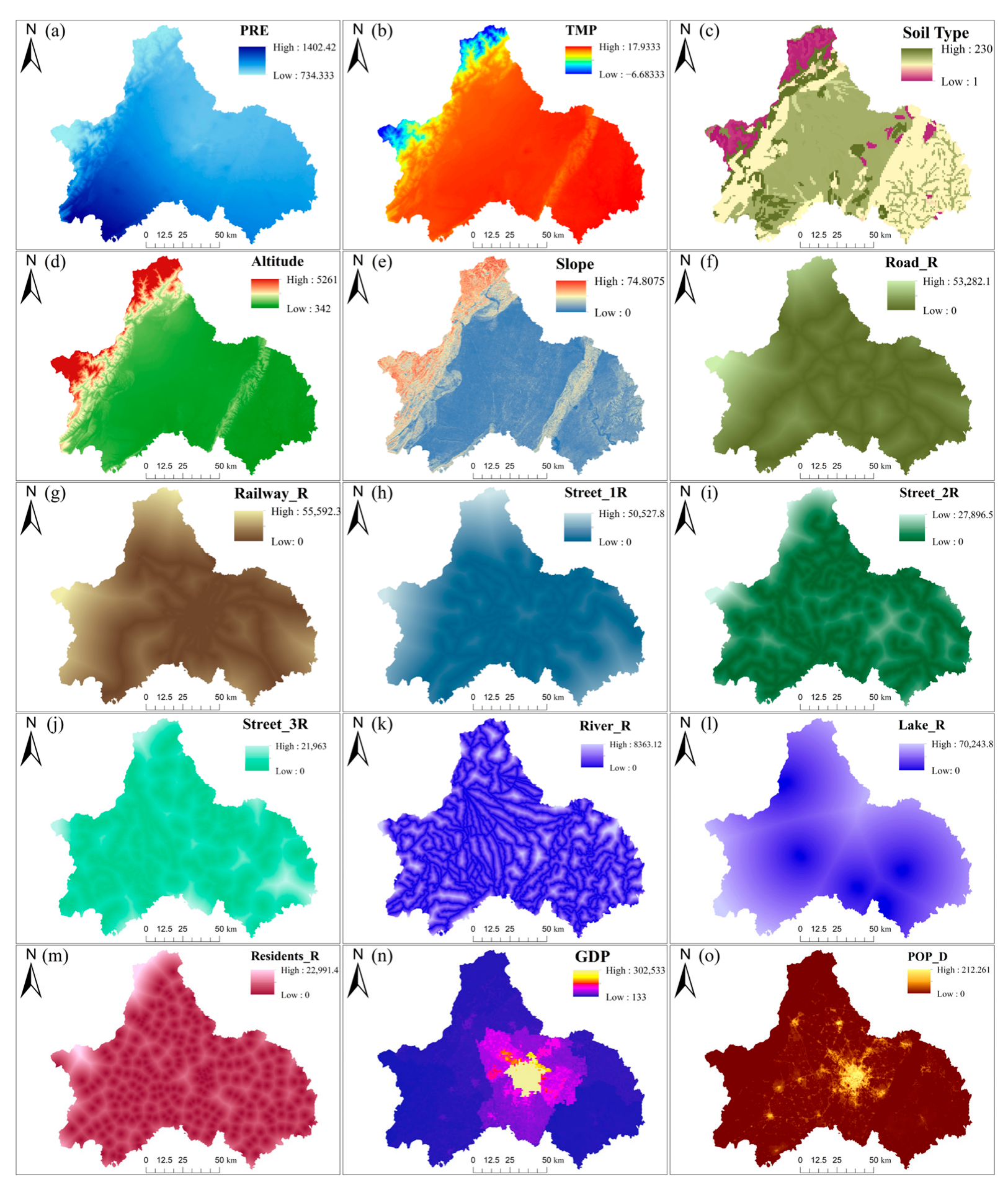
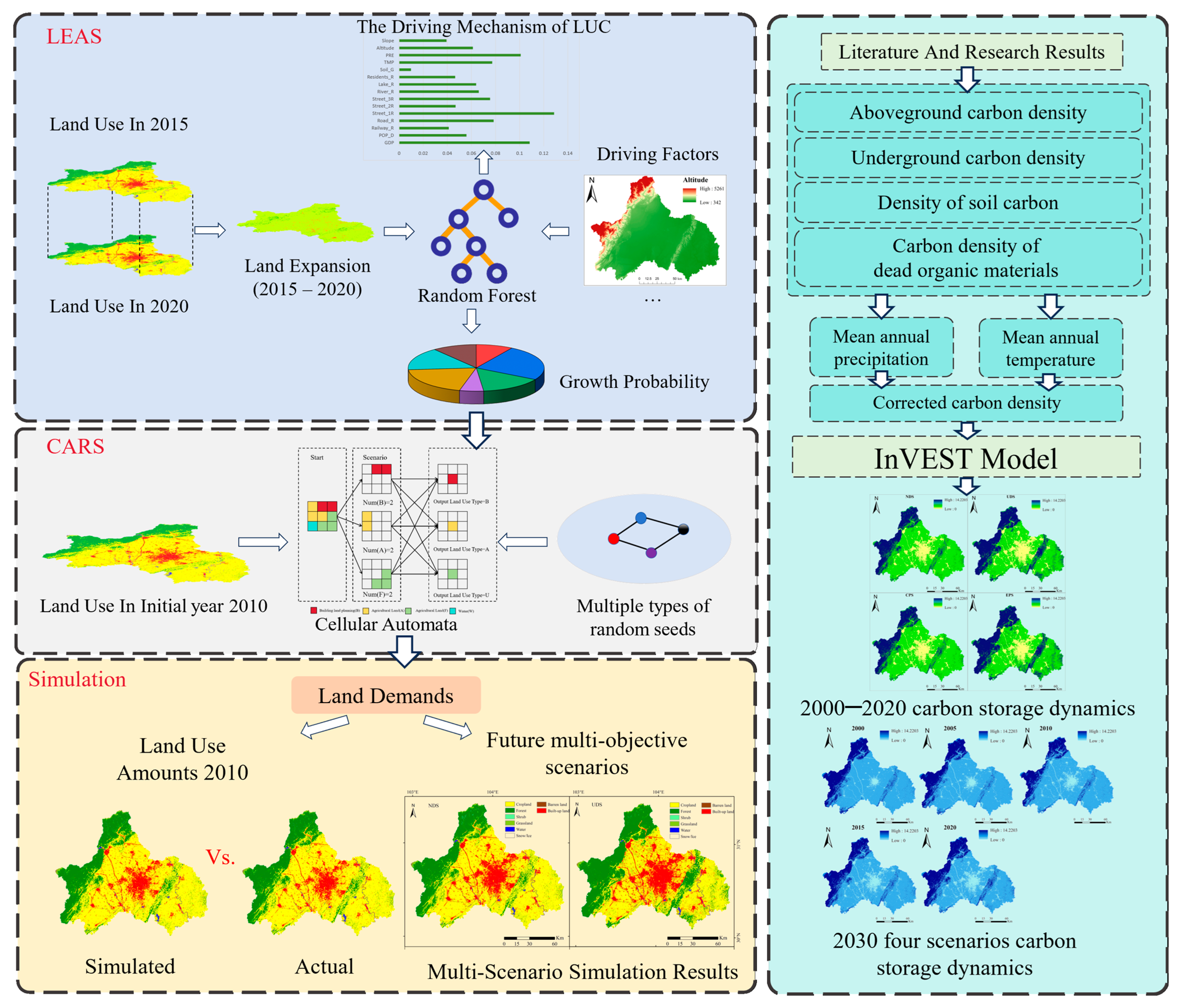
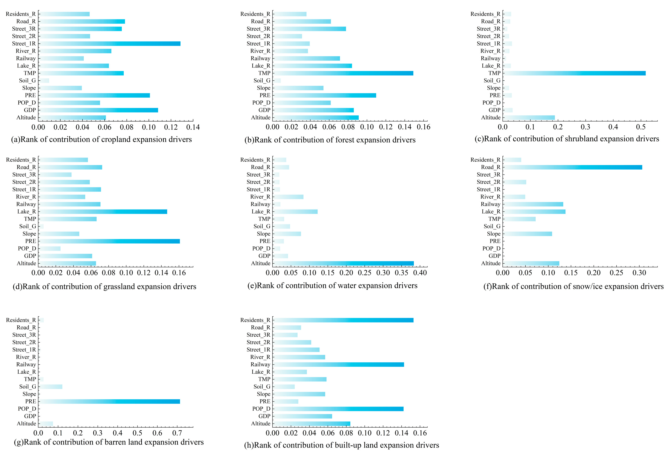
In this study, we employed the PLUS and InVEST models to simulate and predict spatiotemporal changes in land use and carbon stocks in Chengdu. The PLUS model captures the spatial self-organizing characteristics and randomness of LULCC through LEAS and CARS strategies, while utilizing the random forest algorithm to address nonlinear relationships among multiple drivers [
29,
32]. Simulation results usually exhibit high consistency with actual LULCC patterns, and model accuracy is generally satisfactory [
56,
57,
58]. The InVEST model provides a land-type-based carbon stock estimation method, which allows for spatial analysis of large-scale regional carbon stocks, and facilitates comparisons of carbon stock changes under different development scenarios [
59,
60,
61]. Compared to traditional field surveys or biomass measurements, this research method has significant advantages in spatial coverage, data acquisition efficiency, and scenario prediction capabilities [
62,
63,
64,
65].
The land use in Chengdu is characterized by “plains dominated by cropland and hills dominated by forest and grassland”, which is closely related to topography, climate, and socioeconomic factors. This is due to the flat topography, fertile soil, and rich water resources of the plains, which are suitable for agricultural development, and thus have a high proportion of cropland. In contrast, the hilly topography is rugged and transportation is inconvenient, making it less favorable for cultivation and urban expansion, thus supporting more forest and grassland [
66,
67,
68]. The drivers of LULCC include rapid urbanization, transportation infrastructure development, population growth, and industrial restructuring. The conversion of cropland to built-up land is primarily concentrated in areas near cities and convenient for transportation, which is highly correlated with population density and the spatial distribution of road networks [
69,
70]. Moreover, ecological conservation policies and cropland protection measures have a significant effect on maintaining forests and cropland. For example, the “Ecological Red Line” and “Farmland Protection” policies have greatly decreased the risk of excessive land development [
71,
72,
73].
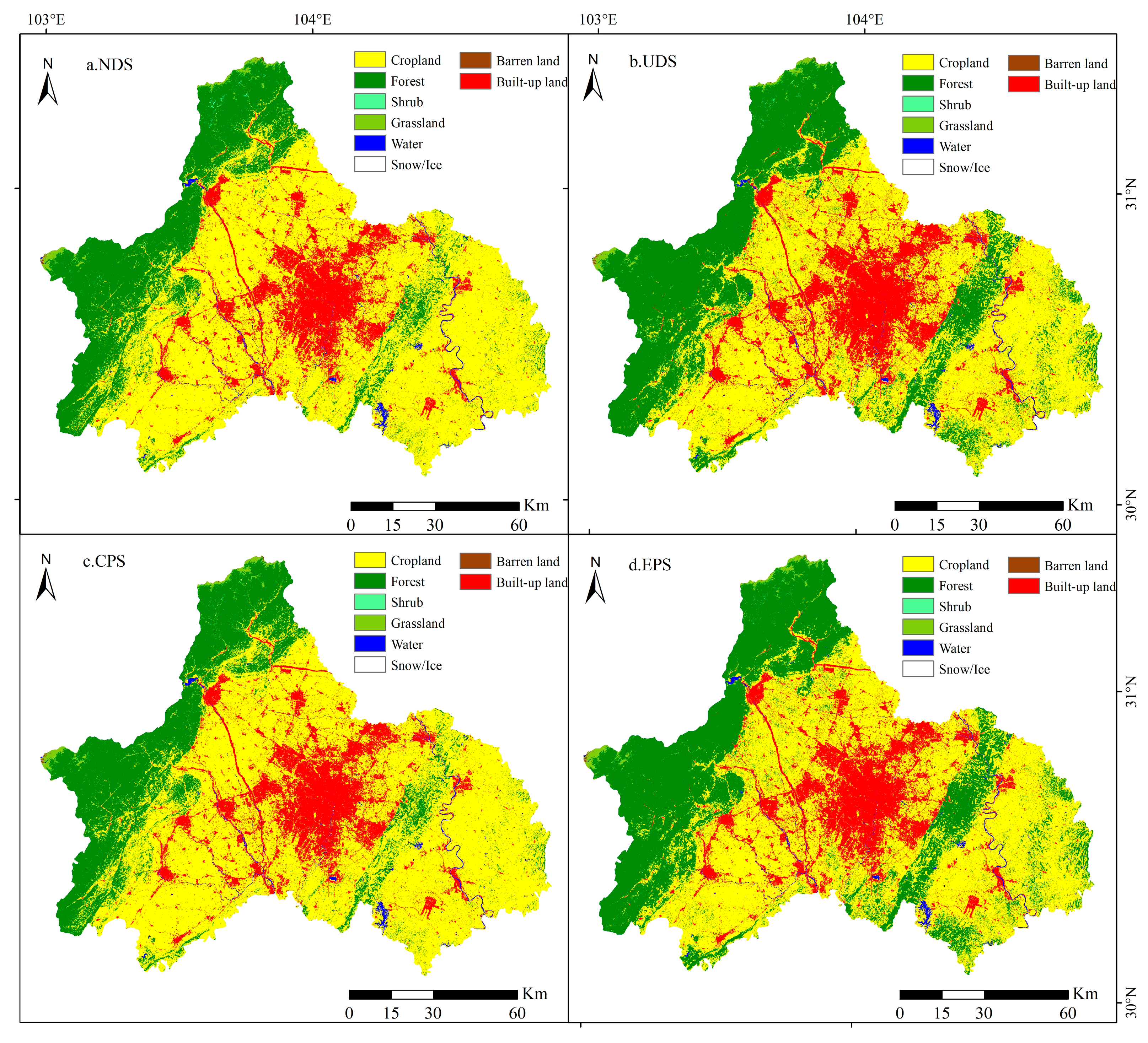
Under different development scenarios, the land use changes in the future (2030) of Chengdu showed significant differences. In the natural development scenario, land use trends continue the patterns observed over the past two decades (2000–2020), with built-up land gradually expanding. In the urban priority scenario, the expansion of built-up land accelerates. In the cropland protection and ecological conservation scenarios, cropland and forest remain relatively stable, while ecological spaces are optimized. Policy factors have a regulatory effect on land use, as LULCC is not only constrained by natural conditions, but also dependent on socioeconomic development strategies and planning management [
74,
75,
76,
77,
78,
79]. Future land use in Chengdu may change into a pattern of balanced development between urban expansion and ecological conservation. Li et al. (2023) [
30] found that Kunming’s carbon storage continuously declined from 2000 to 2020 due to urbanization and expansion of built-up land, especially in low-altitude areas. However, the implementation of ecological red-line policies and restoration measures effectively mitigated carbon loss, with forest conservation playing a crucial role. Comparably, Chengdu experienced carbon loss under rapid urban expansion, but stricter ecological protection and forest restoration policies have led to partial recovery in mountainous regions [
30].
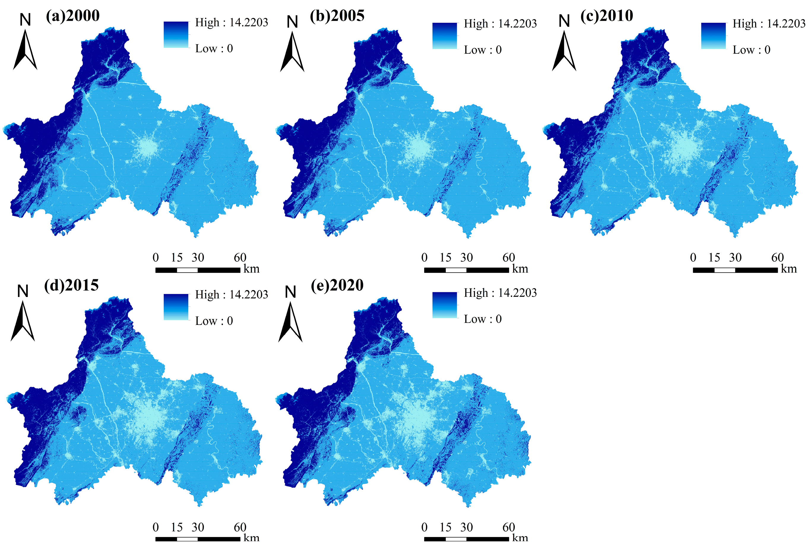
The spatiotemporal distribution of carbon stocks in Chengdu is highly correlated with land use, with higher and more stable carbon stocks found in forest and grassland, while cropland and built-up land have lower carbon stocks. This can be explained by the fact that the spatial differences in carbon stocks are primarily determined by the distribution of land types, vegetation cover, and topographic factors [
80,
81,
82]. The LULCC directly impacts carbon stocks, such as when cropland conversion to built-up land increases carbon emissions, while forest restoration and ecological restoration enhance regional carbon sink capacity. The negative impact of urban expansion on carbon stocks is greatest in plains, where urban development is concentrated. Protecting and restoring the forest in mountainous areas can partially offset carbon losses [
40,
83]. Furthermore, policy and planning measures significantly shape the spatial distribution of carbon stocks, such as “Ecological Red Line Protection”, which can maintain high local carbon stocks [
84,
85,
86].
This study provides valuable insights into the relationship between land use change and carbon storage, but some limitations remain. The socioeconomic data used as driving factors have certain time lags, which may not fully reflect the latest land use trends. In addition, the InVEST model estimates carbon storage based on average carbon density values for each land type, without considering spatial heterogeneity or management differences, which may cause uncertainty in the results. Future work should refine carbon density parameterization and update socioeconomic datasets to improve the model’s accuracy.
5. Conclusions
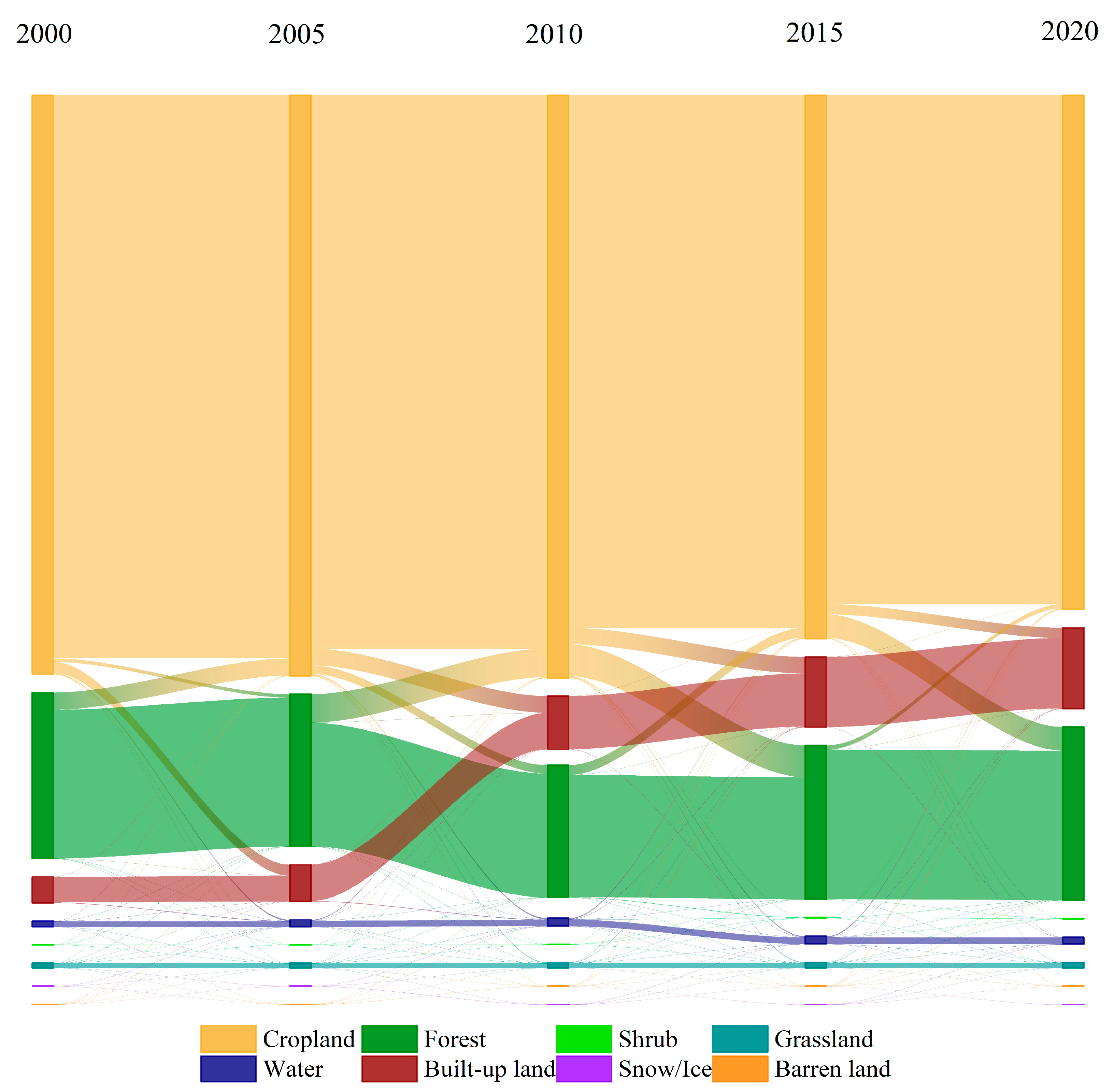
This study employs land use data from 2000 to 2020, and the PLUS-InVEST to simulate and analyze the impact of land use changes on carbon stocks, while exploring the patterns of land use and carbon stock changes in Chengdu in 2030. The research showed that the continuous decrease in cropland and rapid expansion of built-up land during 2000–2020 caused a decline in regional carbon stocks. Urbanization is an important driver of carbon stock decrease. Chengdu’s carbon stocks show a spatial pattern of higher values in the northwest and lower levels in the central area, with cropland and forest contributing the most to regional carbon sinks. Compared to 2020, carbon stocks under all four future development scenarios (2030) show increases, though the differences in increases are significant. Land use policies can significantly influence future carbon sink potential, with ecological priority and cropland protection measures contributing to enhanced regional carbon storage capacity. Chengdu’s future land use will follow an overall trend of “decreasing cropland, expanding construction land, and increasing forest land.” While optimizing the territorial spatial pattern and implementing the “dual carbon” strategy hold positive implications for regional low-carbon transformation, it is essential to acknowledge the practical constraints arising from rapid urbanization. These include rigid demands for construction land expansion driven by economic growth and spatial conflicts between cropland protection and urban development, which pose significant barriers to policy implementation. To further balance urban growth and carbon goals, future planning in Chengdu should prioritize compact urban development and enhanced ecological protection. The Longmen and Longquan Mountains should remain key conservation zones due to their high carbon storage capacity. Strengthening forest restoration and cropland protection will help maintain regional carbon sinks and support sustainable development. This study provides a reference for policymakers, demonstrating that optimizing territorial space and implementing the “dual carbon” strategy can contribute to regional low-carbon transformation and sustainable development.

