Abstract
By combining social, ecological, and communal elements, urban parks significantly improve the quality of urban life. This paper explores the revitalization proposal for Areos Park in Tripoli, Greece, viewing it as an urban palimpsest reflecting layers of history, culture, and nature. While historically evolving from exclusive enclaves to vital public spaces fostering social equity and well-being, many urban parks, including those in Greece, suffer from neglect and underfunding, diminishing their landscape value and necessitating revitalization. Areos Park exemplifies these challenges, making it an ideal case study for exploring effective urban park revitalization strategies and demonstrating how urban areas can host critical landscape functions. Utilizing a design-based research (DBR) methodology, a design plan is proposed. The architectural concept focuses on revamping key areas, restoring historical features, adding small constructions, and repurposing existing buildings for community and educational uses. Concurrently, the landscape concept emphasizes biodiversity enrichment and ecological restoration through permeable surfaces and native Mediterranean vegetation, contributing to urban resilience to climate change. The overall design prioritizes accessibility and spatial connectedness to create an inclusive, resilient, and adaptable urban park addressing contemporary sustainability challenges and biodiversity loss. The project aims to establish Areos Park as a model for sustainable urban park regeneration in small cities, blending ecological enhancement with historical preservation.
1. Introduction
Gardens and parks are carefully crafted landscapes, blending nature and art to reflect human creativity in a specific time and place. Beyond conventional economic measures, their importance is becoming more recognized for both their tangible and intangible services to the preservation of ecosystem functions and biodiversity within the urban fabric. Urban parks, in particular, integrate the built and natural environment, hold important landscape value, and are acknowledged as essential elements of urban life. This is because they provide platforms for political and social expression, together with environmental sustainability and public health enhancement.
Originally intended for the enjoyment of the affluent, urban parks were designed after private gardens and estates. Later on, the social movement of the early 19th century promoted the establishment of parks as public areas to give working-class communities access to green areas and leisure activities as industrialization and urbanization accelerated [1,2]. A great paradigm of the era is the Garden City movement, a town-planning idea that aimed to combine the benefits of urban living with rural landscapes [3,4]. Parks, then, were established and recognized as vital elements of urban life that promoted social equality and public health. By the 20th century, their use had grown beyond recreational areas to include spaces with more extensive social, ecological, and economic purposes. However, they experienced -and still do- problems with underfunding and neglect as cities became denser and more people left the city for leisure. Thus, to guarantee that urban parks continue to focus on sustainable urban living and meet societal needs, revitalization strategies grounded in green infrastructure (GI) principles are increasingly necessary to address biodiversity loss, inequality, human well-being, and urban resilience [5].
Despite the recognition of the value of nature-based sensitive urban park design, though, there is still a limited understanding of how regenerating strategies can balance historical preservation with contemporary ecological and social demands, especially in cities of a smaller scale. Moreover, very few of these studies and design proposals conduct ecological performance metrics to validate the design outcomes and therefore extract transferable lessons and strategies.
To address these gaps, this research is guided by three questions:
What strategies allow urban park redesign to balance historical preservation with contemporary ecological and social needs?
How do ecological performance metrics validate the effectiveness of the design approach?
What lessons and design principles from the Areos Park revitalization can inform similar projects in small cities?
1.1. Redesigning Urban Parks
The design—or even the redesign—of a park requires a thoughtful integration of both architectural and landscape elements to improve sustainability, functionality, and inclusion. Parks are more than just preserved green spaces—they must serve the social, cultural, and recreational needs of the community while maintaining ecological integrity [6,7,8]. One of the first urban studies of public spaces, undertaken by Austrian architect Camillo Sitte in the late 1800s, underlined the importance of comfort and architectural excellence in urban squares. Sitte believes that a public place, such as an urban park, needs to be more than just an open space; rather, it ought to be a well-planned architectural environment that evokes a sense of intimacy, akin to a room in a house [9].
In terms of improving sustainability, effective park design focuses on incorporating natural elements such as native vegetation and permeable surfaces, important GI elements, which help improve biodiversity and reduce urban heat [10,11,12,13]. The use of durable and eco-friendly materials in pathways, seating, and recreational zones enhances the park’s longevity and aesthetic appeal [14]. A city park, especially in modern urban areas, should offer an escape from the crowded, built environment, providing a space filled with diverse colors, textures, and natural features. Successful parks often mimic nature by incorporating woods, meadows, streams, and rocks, blending human-made designs with natural landscapes [15]. In fact, parks that achieve this natural balance, using organic and dynamic layouts, tend to be more successful than those with rigid geometries.
Inclusivity is an important component of park design, and in order to foster it and represent the many needs of the community, the design process should initially consider accessibility, urban growth, and demographic shifts [16]. Moreover, parks should be accessible to everyone, including people with disabilities, which can be achieved through universal design principles like barrier-free paths, tactile paving, and ergonomic seating [17,18]. Involving the local communities in the process helps to initially integrate them, and therefore reflect in the result the cultural needs and values of the users, creating in that way a sense of ownership and belonging [18]. Additionally, parks may promote interaction and guarantee safety by implementing adaptable event areas, interactive installations, and clear signage [19].
It should be clear by now that park designs can generally not follow the one-fits-all logic but must be flexible and responsive to the changing urban terrain, demographic fluctuations, and growing recreational requirements [6,20]. Evaluating public spaces based on criteria such as inclusiveness, meaningfulness, safety, and comfort can guide the design process to create environments that encourage social interaction and community involvement [18,21].
1.2. Unban Parks and the Case of Greece
1.2.1. Neglecting Urban Parks
Greece’s historic gardens and urban parks continue to be disregarded, sometimes due to neglect, a lack of knowledge, or inefficient administration. Unlike some Northern European countries, where gardens and parks have long been an important aspect of cultural and urban development, Greece’s history of incorporating green spaces into its cities is not long. More specifically, in high-density and crowded cities such as Athens and Thessaloniki, public green spaces are uncommon, with paved and quite unfamiliar spaces frequently replacing parks, while in rural locations, gardens are more casual and functional, combining decorative characteristics with useful applications [7,22].
Weak legal recognition and disjointed governance make it difficult to preserve Greece’s historic parks and gardens. Despite their existence, protective designations like “historic place,” “work of art,” and “landscape of outstanding natural beauty” are nevertheless ambiguous and lack specific management standards [22]. Although protected landscapes are recognized by the Greek Biodiversity Law 3937/2011, the social, ecological, and cultural relevance of planned urban parks is not addressed. Furthermore, Greece has not yet incorporated the European Landscape Convention’s (2010) sustainable landscape principles into its urban planning.
In addition to the lack of legal frameworks, fast urbanization, socioeconomic constraints, and inconsistent upkeep have further devalued those green areas. Urban parks are vulnerable to deterioration since Greek cities have not adopted GI for resilience as quickly as other European cities [22]. Camillo Sitte also states the significance of enclosed, thoughtfully designed public areas that promote comfort and engagement in his work on urban squares [9]. It is obvious that this viewpoint is relevant to Greece, where city squares and historic parks may not have the architectural and spatial coherence required for effective public engagement, despite their cultural significance. This situation shows how urgently Greece demands a framework for the quantification of urban ecosystem components, necessary for evaluating the significant effects of land use and development policies on the environment, culture, and landscape.
A case study demonstrating these challenges and possibilities is Areos Park in the Greek city of Tripoli. The city center park has been neglected and underutilized despite its ecological and historical significance. Thus, a thorough restoration plan that balances modern urban demands and cultural preservation is necessary to address these issues. Areos Park can therefore be used as a paradigm and an applied model for sustainable urban park redesign in Greece by incorporating the concepts of adaptive reuse, biodiversity enhancement, and participation of the community.
1.2.2. Recent Development of Urban Parks in Greece
Particularly in smaller cities dealing with space constraints and environmental degradation, sustainability, cultural continuity, and ecological sensitivity have become more and more important in Greek urban park development in recent years. In response to increasing urban pressures, many cities are reassessing damaged or underutilized open spaces through landscape interventions that seek to improve cultural identity while also restoring ecological function. Such an example of how historical narrative and careful planting may transform abandoned infrastructure into a green public space is a design proposal in Megara that aims to transform an old railway station into a linear park [23]. A similar plan was put out to revitalize Thessaloniki’s Konstantinidis stream in order to incorporate natural hydrological characteristics into an open-space network, improving ecological interconnectedness and creating a multipurpose urban landscape [24]. Even initiatives in the enormous Greek capital city of Athens—such as “The Green Line,” which envisions a biodiversity corridor along the city’s old railway infrastructure—show how cities can use thoughtful material and spatial design to balance ecology with urban density [25,26]. Since these proposals focus on bioclimatic planning, permeable surfaces, and pedestrian-oriented spatial arrangements, they can work as adaptable models and guidelines for small city settings where resources may be scarce but environmental and social demands are still urgent.
The work of the landscape architect and sculptor Nella Golanda in Larissa, a small-scale city similar to Tripoli, is among the most prominent implemented examples of context-sensitive park design in Greece [Figure 1]. Her interventions demonstrate the integration of architecture, landscape, and cultural memory and focus on incorporating historical and archeological strata into the city’s material and physical structure. Golanda used minimalist architectural elements, such as stone pathways, sculptural seating, and water features, in her redesign of public areas close to Larissa’s ancient theater. The goal was to create a space that is both functional and meditative, engaging with the past while meeting modern urban needs [27]. In order to direct movement and frame vistas and promote both aesthetic appreciation and historical understanding, the landscape strategy made careful use of native vegetation and spatial continuity. Golanda’s work is deeply rooted in phenomenological design principles, where materiality, sensory experience, and site-specific sensory experience converge. Thus, her approach gives an important reference point for reimagining Areos Park in Tripoli, especially regarding the role of design in reinforcing civic identity through subtle, site-specific sensory experience.
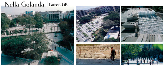
Figure 1.
Nella Golanda’s work in Larissa’s Tachidromiou Square. Retrieved by https://rm.coe.int/168048d933 (accessed on 10 May 2025) [authors’ proceeding].
2. Materials and Methods
Urban parks are recognized as important cultural and ecological spaces that bring together history, nature, and community, functioning as living monuments to a city’s past and environmental resilience. In this article, the landscape design proposal for the revitalization of Areos Park in Tripoli is presented as a case study that merges historical preservation, ecological sustainability, and the participation of the community. The project considers and envisions the park as a landscape palimpsest, where layers of history, culture, and nature coexist and interact [28,29], resulting in a dynamic area that represents both the city’s past and future. Furthermore, the design blends the park into the surrounding urban fabric, improving spatial connectedness and adding to the city’s green infrastructure. The proposal includes the building of a central square along Kalavryton Street, which will act as a uniting element, connecting the park’s dispersed portions and improving accessibility for all users.
This study followed a design-based research (DBR) methodology, which uses design as both a process and an outcome to address complex and real situations [30,31,32], and was structured in four iterative stages: problem identification, design concept development, design synthesis and evaluation, and knowledge output and future implementation [Figure 2]. This method is especially useful in landscape architecture, where repeated cycles of research, design, testing, and modification are required to account for the changing dynamics of biological systems, cultural legacy, and stakeholder needs. DBR facilitates the production of new knowledge by merging the practical and theoretical components of design, while also providing functional and impactful solutions.
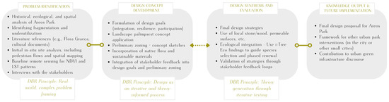
Figure 2.
The DBR methodology [author’s processing].
During the first stage, the problem identification stage, in situ spatial analyses and pedestrian flow mapping were conducted, identifying the weaknesses of the existing layout of the park, such as the fragmentation and the underutilization of several parts. These observations were paired with ecological, cultural, and historical references to better comprehend the difficulties affecting Areos Park. Historical data, such as the Flora Graeca and regional historical documents, aided in gathering information to incorporate native Mediterranean plants, strengthening in this way the park’s ecological and cultural heritage [33,34]. Moreover, remote sensing analysis provided baseline data on the park’s environmental evaluation, showing the amount of green space and the microclimatic patterns in the park and the nearby urban area. In order to define design priorities and set quantifiable ecological and social objectives, the first stage’s study findings were combined with stakeholder involvement through meetings and interviews that included the opinions of local users, technical staff, and municipal officials.
In the design concept development stage, in order to improve spatial connectedness and incorporate the park into the urban fabric, especially along Kalavryton Street, a design strategy was created after the initial assessment. The layout itself tries to bring disparate sections together to create a unified, easily navigable environment. While native Mediterranean species improve biodiversity and ecological resilience, sustainable materials, including locally sourced wood and stone, reduce their negative effects on the environment. Water management and sustainability issues are addressed by innovative ground materials. In order to promote long-term sustainability, the approach places a high priority on protecting native trees, which are essential for controlling the microclimate, and introducing native species [34]. Water management and climate resilience are further enhanced by permeable materials and ground systems [13,35].
The DBR method prioritizes the value of the process through visualization and documentation. Design concepts were conveyed using models, diagrams, and conceptual sketches, while feedback loops enabled these images to be improved in response to site-specific circumstances and input from local stakeholders. The final design proposal was more flexible as a result of this open and inclusive process.
3. The Case Study
3.1. Areos Park Location
Areos Park is located in the city of Tripoli, the capital of Arcadia in the Peloponnese, Greece, a city with historical, cultural, and ecological significance [Figure 3]. Tripoli is located at an altitude of 650 m, is one of Greece’s highest cities, and serves as a central hub, connecting the Peloponnese’s coastal and mountainous regions [36]. Surrounded by the Mainalo and Parnon mountain ranges, Tripoli benefits from a unique microclimate and enhanced ecosystems. This rich biodiversity of the broader Arcadia region has also inspired many works of literature, music, and art, and was famously idealized by the Roman poet Virgil in his Eclogues, where it was depicted as a utopian land. Additionally, his reference to Maenalon mountain ties pastoral poetry to Arcadia’s enduring tradition of love laments. Mt. Maenalus, ever resounding with the songs of shepherds and Pan’s flute, symbolizes poetic inspiration and sorrow [37,38].
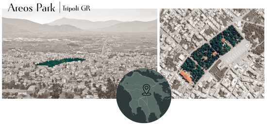
Figure 3.
Aeros Park as the main green space in Tripoli [author’s processing]. On the left: photo retrieved by https://www.visitgreece.gr/el/mainland/peloponnese/tripoli/ (accessed on 20 March 2025). On the right: Google Earth view.
Eclogue 6.47-48:
“Here in the land of Arcadia, the shade of the beech tree is deep, and the soft wind carries the scent of flowers.” (Translation: “Hic ubi in Arcadia saltus, / Fagetique altaeque beech,”). [39]
In recent decades, Tripoli has encountered urbanization and environmental issues, such as population growth and resource depletion, and is an ideal area for investigating creative approaches to landscape design and urban resilience, using its particular location, climate, and historical context.
3.2. Areos Park as a Palimpsest of Ecological Significance and Cultural Continuity
Located in the center of Tripoli, Areos Park is one of the city’s primary public areas and a very important ecological area and historical monument that significantly contributes to the urban and cultural landscape of the city. After Greece obtained independence from the Ottoman Empire in the early 19th century during the Greek War, the park was created. As a result, it became an important location for national commemoration, honoring the people and occasions that influenced modern-day Greece. Grand pathways, monuments, and open areas commemorating the country’s historical struggle for freedom are all part of its overall design, which embodies the neoclassical ideals of the time [Figure 4].
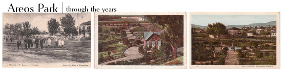
Figure 4.
The evolution of the park from an empty field to designed gardens. The photographs were kindly provided by Christos H. Mitsias and shown in his book Tripoli 1830–2000: A nostalgic retrospect [40] [authors’ proceeding].
The park’s current state incorporates Mediterranean plantings, including drought-resistant species well-suited to the local region’s harsh climate. The park’s ecological health is indeed maintained by these species, many of which were initially recorded during the 18th-century Flora Graeca trip [34,41]. They overall support the local environment and increase biodiversity [34]. It is worth mentioning that the catalog of Flora Graeca documented around 200 plant taxa in the Peloponnese [Figure 5], thus creating a historical link between the park’s present vegetation and the area’s rich botanical past.

Figure 5.
A collection of plants by the archive of Flora Graeca, retrieved by Oxford, Bodleian Library Ms Sherard 242: https://digital.bodleian.ox.ac.uk/collections/flora-and-fauna-graeca/ (accessed on 12 April 2025).
From its memorial function, Areos Park has developed throughout time into a green urban area that meets Tripoli’s ecological needs. As urbanization grew over time, it underwent several alterations, including the addition of modern utilities and features like benches and fountains (Figure 6), and the landscape design was further elaborated, ensuring that it would remain a functional public space while maintaining its historic charm [42].
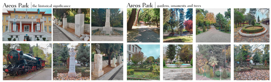
Figure 6.
Photographs taken by the authors during the regular site visits. On the left: The Apostolopoulio Cultural Center, the historical train placed in the park, and several sculptures and busts of important historical local figures. On the right: Designed gardens, ornaments like fountains, big pathways that guide the visitor and highlight entrances or gathering places, and different types of trees used to enrich the park’s greenery [authors’ proceeding].
Areos Park, thus, embodies the concept of an urban palimpsest [Figure 7]—a dynamic space where layers of history, culture, and nature intersect and evolve over time [28,29,43]. Those layers shape our understanding of a site, and the concept of palimpsest serves as a tool to describe and design landscapes by revealing site-inherent values. Areos Park, as an urban landscape, reflects the cumulative imprints of different historical eras, transforming inherited elements into an integrated urban heritage system [44,45,46]. The park’s design acknowledges these historical remnants, including architectural influences, memorial traces, and ecological features, that contribute to its identity and continuity [46,47].
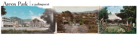
Figure 7.
The elaboration of the concept of the palimpsest of Areos Park. Different layers of history, one upon the other. The photographs were kindly provided by Christos H. Mitsias and shown in his book Tripoli 1830–2000: A nostalgic retrospect [40] [authors’ proceeding].
I emphasize that the built environment is a sort of palimpsest, a document in which one layer of writing has been scraped off, and another one applied. An acute, mindful explorer who holds up the palimpsest to the light sees something of the earlier message, and a careful, confident explorer of the built environment soon sees all sorts of traces of past generations. [43]
3.3. Current Situation Analysis
3.3.1. In Situ Analysis
The first phase of the design strategy focused on better understanding the site and its surroundings. This initial stage involves comprehensive in situ analysis, which provides critical insights into the park’s existing conditions, together with some preliminary examination of its historical context and biodiversity factors. In order to solve ecological and social issues, the spatial analysis entails evaluating the park’s fragmentation and identifying regions with low functionality and inadequate accessibility.
Regarding the position of the site, Areos Park is bordered by key urban landmarks such as Areos Square to the south, Prophet Elias Church to the east, and the Apostolopouleio Cultural Center to the west. Three separate zones, each with varying degrees of functioning and design coherence, are created by the park’s division by main roadways [Figure 8].
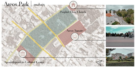
Figure 8.
The analysis of the park.  The green area of the park.
  The main streets crossing the park.
  The surrounding important elements. On the right, the Prophet Elias Church, Areos Square, and the Apostolopouleio Cultural Center [authors’ archive and proceeding].
The green area of the park. The main streets crossing the park. The surrounding important elements. On the right, the Prophet Elias Church, Areos Square, and the Apostolopouleio Cultural Center [authors’ archive and proceeding].
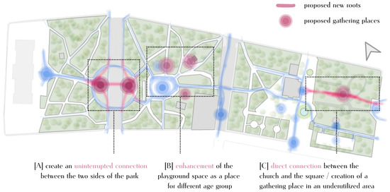
A lot of important information has been gathered through many site visits and inspections, and is represented in Figure 9. Low foot traffic was found to be mostly caused by the lack of active usage in the western region [A], which is adjacent to the Cultural Center. Inconsistent illumination, muddled or damaged pathways, a dearth of obvious places to unwind, and deteriorated infrastructure—such as deteriorated pavement and benches—all work against the comfort of the visitors and make the area less appealing. On the contrary, in the central area [B], there is more activity, and that is where the playground is located. There is a much more vibrant environment, especially throughout the day when children, parents, and teenagers use the space. The playground remains a solitary element because there are not many adjacent seating areas or other amenities; hence, people tend to develop their own improvised, unofficial gathering spots.
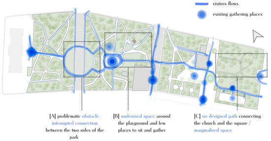
Figure 9.
Visitors’ flow map [authors’ proceeding].
In the meantime, poor architectural coherence is also present in this area because of the circular garden parts that hinder pedestrian flow and block views, especially in the direction of the Cultural Center. The park’s eastern section [C] receives the most visitors; it is primarily a place to relax with open areas and a few modest restaurants, with people of all age groups going there to unwind and socialize. However, because of inadequate walkways, portions of the property surrounding Prophet Elias Church are still unusable. In general, there are indications of deterioration all across the park, with issues such as broken seats, damaged pavement, and poor lighting, but those are just a few of the park’s many signs of decay [Figure 10]. This generalized, fragmented character of the park and its inability to function as a cohesive and vivid urban green space is further exacerbated by the neglected planted parts.
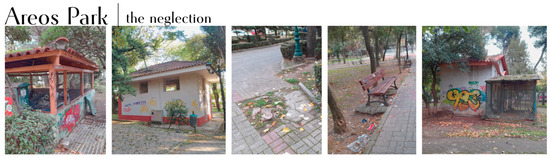
Figure 10.
The neglected and deteriorated areas of Areos Park with visual damages and vandalizations as observed during the site visits [authors’ archive and proceeding].
In addition to addressing infrastructure developments and spatial connectivity, this in situ site analysis showed the necessity for a strategic redesign that improves the overall user experience by creating a more cohesive and approachable green area. At this point of the analysis, in order to define the strategies that respond to the existing problems, Figure 11 was formed, briefly summarizing the existing weaknesses of the three parts of the park and the proposed strategies that should be applied to them.
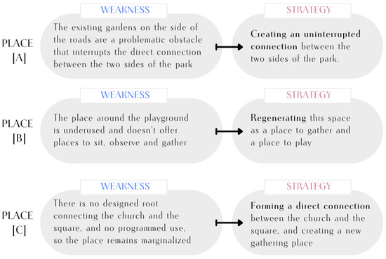
Figure 11.
The weaknesses that were identified and the proposed strategies.
It should, of course, be noted that the initial phase was essential to capture the park’s different layers of history and nature, and this strategy is consistent with the arguments made by Nijhuis and de Vries (2020), who maintain that a comprehensive understanding of sustainability and context is necessary for landscape design. The findings of the in situ analysis provide insight into the current situation and how the community views and uses the space, which in turn informs the design approach [30].
3.3.2. Interviews with the Stakeholders as Feedback for the Design
In order to form a design strategy that answers the local needs and challenges, we needed to better comprehend the social and functional reality of Areos Park. Apart from the on-site observations that initially took place, several interviews and meetings with the local stakeholders were conducted, with the process and the consolidated results shown in Table 1. In those meetings, the insights from the main municipal representatives, including the mayor, the vice mayor, and technical staff, revealed that the park is perceived not only as a recreational space but also as a symbolic “heart of the city”, a focal point for civic life and community interaction, and this is why it is of major importance to enhance its identity. From a practical standpoint, they emphasized the necessity of better equipment and facilities, increased nighttime safety, and uninterrupted pedestrian traffic to facilitate organized and recreational activities. In order to maintain ecological continuity, the municipal agronomist identified diseased or dangerous trees, gave vital technical information on the tree inventory, and emphasized the significance of a phased canopy regeneration plan. In order to lower traffic speeds and create safer access points, the transportation engineer’s input concentrated on pedestrian safety and circulation and suggested paving and road alignment changes.

Table 1.
Synthesis of stakeholder interviews and inputs, and the derived identified design priorities.
Patterns of underutilization and adaptive behaviors were discovered through informal discussions with park visitors and on-site observations, which complemented the institutional findings. Many guests said they felt uneasy in badly maintained or poorly lit areas and would rather congregate close to cafes or in central locations. There is a contradiction between the needs of users and the physical arrangement, as seen by several reports of benches being moved to establish unofficial gathering areas.
The outcomes of the stakeholder interviews, together with the in situ study, determined the fundamental priorities for the design strategy going forward [Table 1]. In terms of spatial programming, the future design must include multipurpose gathering areas and spaces that support both organized and informal activities, such as open workout zones for youth and community-focused spaces for families and senior citizens. In order to improve safety and accessibility for all users, it is evident that a network of pedestrian paths that are both inclusive and safe must be developed at the circulation level. Low-speed restrictions and redesigned access surrounding Kalavryton Street should receive special attention.
Maintenance and safety concerns stress how crucial it is to improve visibility in unused spaces to deter vandalism and foster a sense of security, particularly at night. In order to improve biodiversity and long-term resilience, a canopy renewal strategy will be necessary to add native, ecologically useful species to the park. Last but not least, the park’s identity is consistently stressed, demonstrating the necessity of incorporating regional resources and culturally important factors to guarantee that the revitalized park captures Tripoli’s character.
3.3.3. Areos Park as the Green Core of the City
Designing a project that is both sustainable and sensitive to the local climate requires an understanding of the biological and climatic conditions of Areos Park [30]. This chapter explores the park’s vegetation dynamics, cooling function, and broader impact on Tripoli’s urban microclimate in order to set the basis for targeted and measurable changes. As part of the environmental baseline assessment, Google Earth Engine (GEE) was used to evaluate high-resolution Sentinel-2 Normalized Difference Vegetation Index (NDVI) and Landsat-9 Land Surface Temperature (LST) information for the summer reference period from June to September 2024 [Figure 12]. This geospatial methodology allowed the formation of an objective and accurate technique to determine the distribution of green cover, surface temperature patterns, and vegetation health over Areos Park and the entire Tripoli region. According to the research, the park has an average NDVI of 0.61 and approximately 79% green cover, indicating thick and healthy vegetation [Table 2]. In keeping with this, mean surface temperatures in the park were lower (about 40 °C) than in the surrounding urban fabric, where mean LST soared to around 43.7 °C and NDVI values dropped to around 0.23.
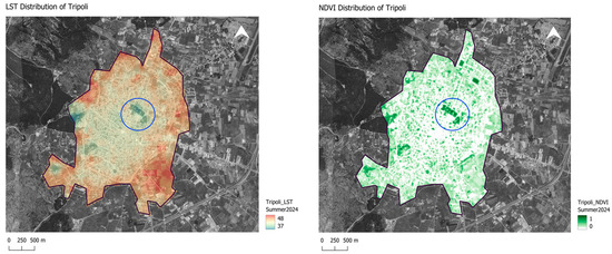
Figure 12.
Baseline environmental indicators—NDVI and LST analysis of Areos Park and its surrounding urban context (Summer 2024).
Table 2.
Comparative environmental indicators: Areos Park and the urban and buffer zones (Green Percentage in %, NDVI, and LST in °C). Data referring to the period of Summer 2024 and derived from Sentinel-2 and Landsat-9.
Areos Park’s wider ecological and microclimatic impact on Tripoli’s urban fabric is demonstrated additionally by the study of the buffer zones around the park [Table 2]. NDVI values decreased to about 0.21 within a 500 m radius, while mean LST increased to about 42.7 °C. The urban thermal profile was reflected by the mean surface temperatures, which averaged ~43.4 °C, and the low vegetation health (NDVI ~ 0.22) within a 1000 m radius. This gradient offers quantifiable proof of the park’s cooling island effect, showing its ability to improve microclimatic comfort and reduce regional urban heat stress. These findings give quantifiable proof of the park’s critical function in minimizing heat island impacts and providing refuge during hot weather, something that is in line with literature demonstrating that urban green spaces serve as significant cool islands by lowering surface and ambient temperatures through shade and evapotranspiration [48,49].
4. The Design Proposal
Through the “Actions and interventions for the sustainable development of the Municipality of Tripoli,” a project funded by the European Union, the park’s historical character and its current function as a green urban area are intended to be balanced. The main goal of the design is to achieve an aesthetic, utilitarian, and ecological upgrade while ensuring that the park will continue to contribute as a key social and environmental asset for the city and address modern climate and urbanization challenges [3,15,18,25,50].
Following the DBR methodology, the first multi-step analytical process that included stakeholder interviews, in situ observations, and remote sensing analyses influenced the park’s design concept [30,31,32]. Important functional and spatial flaws were identified by the on-site assessments, and the interviews brought light to the requirements and goals of the neighborhood [Figure 13]. Additionally, the park’s ecological significance and its function in reducing urban heat were finally underscored by remote sensing data, such as NDVI and LST assessments.
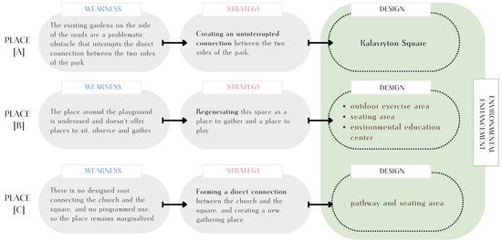
Figure 13.
The proposed design elements derived from the strategies that respond to the weaknesses of Areos Park.
The whole iterative DBR process revealed that balancing historical preservation with contemporary ecological and social needs required a layered approach, and this is why the revitalization of the park is structured around three core objectives: adaptive reuse of existing structures to preserve the cultural identity, expansion of the tree canopy and integration of native species to improve ecological sustainability, and spatial reprogramming to improve spatial connectivity.
These objectives are addressed through two complementary design approaches: the architectural strategy, which focuses on spatial reconfiguration and built interventions, and the landscape strategy, which prioritizes ecological restoration and biodiversity enhancement. Areos Park will become a community-responsive and climate-adaptive urban area in addition to a historical landmark by integrating various viewpoints [51]. The architectural strategy aims to improve spatial organization through interventions and the adaptive reuse of existing structures for community and educational purposes [18,50,52]. The landscape strategy targets strengthening the park’s biodiversity and climate resilience by integrating native Mediterranean flora, enhancing the existing green infrastructure, and therefore the habitat continuity [34,35,53].
In general, the idea emphasizes that any restoration must have more long-term value than the interruptions it may cause. A priori, historic gardens can be perceived as living monuments—their value comes from the fact that they evolve while allowing people to experience and connect with the past in the present [54].
4.1. The Architectural Design Strategy | Constructed Places to Gather
The architectural design strategy focused on both historical preservation and spatial cohesion. Drawing from the principles of system innovation and landscape design as research [30,31], the design integrates previously segmented and underutilized areas of the park into a cohesive whole.
One of the primary challenges identified during the analysis phase was the fragmentation of pedestrian flows and the lack of functional gathering spaces. Existing obstacles, such as the peripheral garden and disconnected pathways, interrupted the movement between different parts of the park [Figure 9]. In response, the proposed design introduces a clear and uninterrupted pedestrian network that links the park’s most significant nodes, including the cultural center, the playground, and the area surrounding the church [Figure 14].
As portrayed in Figure 15, this spatial connectedness is achieved particularly through the formation of a central square along Kalavryton Street that acts as a uniting element and a focal design point. Moreover, the underutilized playground area is transformed into a multi-functional space that integrates seating, shading, and play elements to promote interaction among children, parents, and other visitors. In the same way, the previously marginalized area between the church and the square is activated through a new pathway and the creation of a reprogrammed public space, with a strong physical and visual connection that achieves the park’s cohesion.
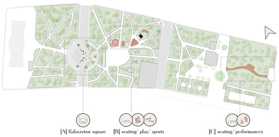
Figure 15.
The general masterplan of the proposal for Areos Park. Together with the construction of the circular square, small constructions are placed on key points inside the park. Kalavryton Square [A]; outdoors exercising area, seating area, and environmental education center [B]; pathway and seating area [C] [authors’ proceeding].
The main design concept is inspired by the Ancient Greek urban planning principles, such as the agora—an open space fostering social interaction and civic engagement [55,56]—while also incorporating elements from Greek folklore and traditional landscape features. In this way, the park’s cultural character is reinforced, resulting in a location that reflects both historical continuity and contemporary urban needs.
4.1.1. The Kalavryton Square | Restoring Connectivity
Since the spatial unification of the park’s sections is a critical goal, the central square along Kalavryton Street [Figure 16] resolves the current division between the park’s Cultural Center and the playground. Inspired by the Ancient Greek agora, a space historically dedicated to social gathering, discourse, and civic life, the design aims to create a central, public, inclusive space, open to any social use.
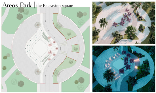
Figure 16.
The plan and visualizations of the Kalavryton Square. The unification of the two sides of the park, which were previously fragmented with no fluid movement between them [authors’ proceeding].
The visitor is guided through linear paths from the park to the main square, from the “inside” to the “outside”. The seamless pedestrian experience eliminates barriers to allow a fluid movement throughout the park while echoing the openness of classical Greek public spaces. Additionally, the linear pathways, with the big tree canopies over them, reflect the stoas of ancient Greece, which provided structured yet open spaces for movement and gathering, blending functionality with aesthetic order [57].
The design, the layout of the square, and the paving employ circular and organic forms, drawing from the enduring symbolism of the circle in Greek philosophy and mythology, where it represents unity, eternity, and the cosmos [58]. The circular layout of the square recalls the orchestras of ancient Greek theaters, spaces where collective experience and performance reinforced social cohesion.
The square itself will not serve merely as a passageway but will be a central meeting point, offering shaded seating, green spaces, and interactive water features, in the form of ground fountains [Figure 17]. Fountains and interactive water features serve as natural gathering areas in modern public spaces, encouraging social interaction and community engagement. The kinetic energy of flowing water creates a welcoming environment, enticing people to gather and enjoy the location.
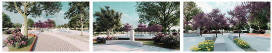
Figure 17.
Visualizations of different angles of the square [authors’ proceeding].
The element of water plays a fundamental role in both practical and symbolic dimensions of urban design, especially in spaces with rich historical and cultural significance such as Areos Park. In ancient Greece, the element of water was not only necessary for daily life, but its presence in public spaces, fountains, or ceremonial basins, provided important spatial points for social interaction [59,60]. Water features in Areos Park’s renovation have a similar dual purpose: interactive fountains give cooling and recreational options, increasing user comfort while also recalling historical and cultural associations with water as a purifying medium and a source of societal unity.
Strategically, by reducing vehicle speed through the construction of semi-circular pedestrian routes, safety is improved while parking places are reduced, making the park more pedestrian-friendly. Furthermore, green mounds and landscaping will help visually and functionally integrate the surrounding greenery into the square, ensuring that existing trees are preserved and incorporated into the new design.
The material selections for the redesign demonstrate a dedication to sustainability and local character. Materials such as locally available stone and wood are preferred for their low environmental impact and aesthetic compatibility with the park’s historical features. Furthermore, the use of new concrete formulations and permeable ground materials provides the park’s resilience to climatic changes and climate stressors, lowering the project’s ecological imprint.
4.1.2. Smaller-Scale Installations | a Dialogue with the Existing
Apart from the main design element, Kalavryton Square, the proposal includes the implementation of smaller constructions in Areos Park that serve as strategic interventions to enhance the park’s functionality and inclusivity without overwhelming the existing landscape [Figure 18]. These subtle but important improvements aim to promote the park as a vivid, multipurpose area by accommodating a variety of users and activities. Overall, a seamless inclusion into the existing park area is ensured by the size of the buildings, the use of soft materials, and the presence of huge existing trees in the design. Thus, rather than imposing upon the landscape, the design embraces it—trees are included in the layout, with their canopies offering natural shade and forming the spatial experience. Trees can be perceived as anchors to space, reinforcing the park’s organic rhythm while adapting to the ever-changing choreography of human activity beneath them.
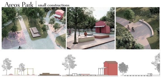
Figure 18.
Visualizations of different angles of the installations inside the park. On the left: Open exercise space, seating area, and environmental education center. In the middle: Seating area and environmental education center. On the right: Pathway and seating area [authors’ proceeding].
Around the playground and other areas of the park, there are custom seating installations that create versatile gathering spots for multiple uses, such as casual meetings, child supervision, or small performances. These seating areas are designed with different levels to accommodate different users, including children and adults, and are more flexible to be used according to any improvised need.
The design itself, along with the placement of the seating structures, is informed by traditional Greek symposium settings, where communal tables encourage dialogue and cultural exchange. In The Symposium in Context, the author examines the spatial arrangements of ancient Greek symposia [Figure 19], highlighting how the configuration of seating fostered dialogue and cultural exchange. The study discusses the use of klinai (couches) arranged around the room’s perimeter [Figure 19], facilitating face-to-face interactions among participants [61]. This layout dynamically promoted social activity and, therefore, reinforced communal bonds through shared experiences.
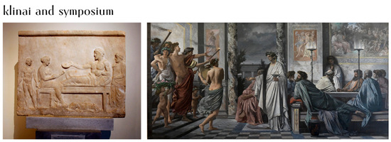
Figure 19.
On the left: Klinai, retrieved by https://en.wikipedia.org/wiki/Klin%C4%93 (accessed on 12 May 2025). On the right: Plato’s Symposium, depiction by Anselm Feuerbach, retrieved by https://en.wikipedia.org/wiki/Symposium (accessed on 12 May 2025).
An expanded play and exercise space with an open, adaptable design close to the current playground is one of the suggested expansions. Teenagers and senior residents can use the space for fitness and relaxation due to the inclusion of soft rubber flooring with natural shapes and low heights. This tactic makes the park more appealing to a larger spectrum of age groups by encouraging physical activity as a kind of play. In this manner, areas are developed that serve children as well as incorporate multigenerational purposes, thereby energizing the community at large.
The conversion of an existing building into an environmental education center is another noteworthy initiative. Located in a highly active part of the park, this building is envisioned as a hub for environmental awareness, providing interactive displays and information about the park’s flora, fauna, and history. This change gives the park an educational and didactic component, transforming it into both a recreational and instructive area, providing an opportunity to host programs held by organizations and schools, and in the end, to enrich the park’s ecological relevance.
The eastern section of the park, currently underutilized, will feature only an open seating area designed to host events and gatherings. With shaded spaces and accessible pathways, the area is intended to accommodate large groups while preserving the natural beauty of the park’s existing tree canopy. This section generally will remain untouched in terms of new structures, ensuring in this way that the balance between the new installations and nature is maintained.
4.2. The Landscape Design Concept | the Trees as Places to Gather
The park lies among the Quercetalia pubescentis forests of deciduous oaks, which are part of the Para-Mediterranean ecological zone. More specifically, it is a member of the mixed evergreen and deciduous shrub subzone Ostryo-Carpinion. However, it also displays traits of the higher-altitude Abieton cephalonicae zone, where the Kefalonian fir (Abies cephalonica) flourishes, because of its elevation and regional climate. Plant species from both upper and lower vegetation zones can coexist in this special climate transition. While species from the lower Mediterranean zone, including myrtle, arbutus, and olive, are frequently harmed by severe winter conditions, species from the higher zones, such as firs, thrive.
The design’s aim is to focus on long-term sustainability while integrating the park into its surroundings. Therefore, the landscape design strategy prioritizes the preservation and enhancement of the rich existing biodiversity and considers ecological, architectural, and bioclimatic parameters in a holistic way. Through the intentional selection of native plants [Figure 20], the park embodies a balance between history and the environment while simultaneously paying tribute to the regional past. In that way, the design guarantees ecological resilience with less upkeep by keeping natural vegetation dynamics rather than strict landscaping [62,63,64].
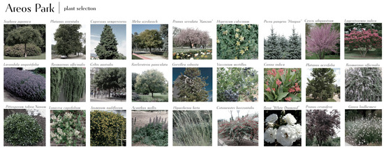
Figure 20.
Some of the new plant species that were chosen to be planted in Areos Park [authors’ proceeding].
It is worth mentioning that native plants are generally preferred for supporting local fauna, though the resources a plant provides are more important than its origin [65]. The park’s ecological strategy prioritizes both native and drought-resistant species in order to minimize maintenance and water consumption. Inspired by Low Impact Urban Design and Development (LIUDD) and Biodiversity Sensitive Urban Design (BSUD), the selection of flora enhances urban biodiversity and supports local habitat [65,66,67]. Plant selection and placement aim to primarily regulate microclimatic conditions by reducing heat through shaded areas, an important regional problem that needs to be solved. Some important tree species that are being implemented, to enhance the already existing ones, include Quercus species (oak), Olea europaea (wild olive), Ulmus species (elm), Pinus species (pine), Cupressus sempervirens (cypress), and Abies cephalonica (Kefalonian fir). Additionally, there are intentionally chosen plants that specifically enhance biodiversity and aesthetic appeal, such as Viburnum tinus (Laurustinus), Myrtus communis (Myrtle), Crataegus monogyna (Hawthorn), and Arbutus unedo (Strawberry Tree). Furthermore, some ground covers and aromatic plants that need low maintenance, such as Rosmarinus officinalis (rosemary), Lavandula angustifolia (lavender), and Thymus vulgaris (thyme), are acknowledged for stabilizing soil and supporting biodiversity.
An important part of the park’s biological and cultural environment is the plane tree (Platanus orientalis). This tree is well-known for its wide canopy, which not only provides plenty of shade that can help reduce urban heat but also improves biodiversity by giving different species a place to live [Figure 21]. Apart from their ecological and landscape value though, the plane trees, are very connected to Greek cultural and natural heritage, a fact that contributes to the park’s status as a historical garden and aligns with the definitions established in the Florence Charter of 1981 for historical gardens, where an emphasis is given on the integration of nature with historical and cultural elements [22,44,64].
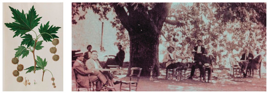
Figure 21.
On the left: Platanus orientalis by the archive of Flora Graeca, retrieved by Oxford, Bodleian Library Ms Sherard 242: https://digital.bodleian.ox.ac.uk/collections/flora-and-fauna-graeca/ (accesses on 12 April 2025). On the right: Platanus shadow as a gathering social space; photo retrieved by https://www.kalimera-arkadia.gr/gortynia/item/82707-platanos-magoulianon-diatiriteo-mnimeio-tis-fysis.html (accesses on 12 April 2025).
In the meantime, plane trees are important in Greek poetry, mythology, and literature; they frequently represent longevity, knowledge, and social gathering. They are particularly mentioned in Homer’s “Iliad”, situated next to the Scamander River, and standing for both tranquility and beauty. Additionally, as Virgil wrote in his Eclogues, “Arcadia, beneath your ancient plane trees...the world stands still”, clearly reflects the tree’s timeless connection to nature and tranquility. In ancient Greece, the plane tree was often planted in public meeting places, known as agoras, where philosophers and scholars gathered. Their prominence in Greek intellectual and civic life is further cemented by Plato’s affiliation with the trees, since he held philosophical debates beneath their shade.
Nikiforos Vrettakos, a modern Greek poet from the Peloponnese, captures the emotional and historical weight of the plane tree in his work, writing,
“Under the plane tree’s shade, the history of the land is told in eaves and roots that remember the battles and the calm of our ancestors’ toil.”
These references reinforce the tree’s status as a living monument to Greek heritage and cultural resilience, deepening its role within the historical and ecological context of Areos Park [41].
The Environmental Benefits of the Trees
The revitalization plan for Areos Park includes, in total, the planting of 71 new trees to enhance its canopy coverage, and therefore the biodiversity and the microclimatic performance of the park. To estimate the potential future canopy coverage of the proposed plantings, we compiled species-specific data for average mature crown diameters from horticultural databases. For instance, Cercis siliquastrum typically reaches a mature crown of approximately 6 m, while Platanus orientalis reaches a much larger canopy, averaging 18 m in urban conditions [68]. These values were used to calculate the canopy area for each species using the formula Area per tree = π × (D/2)2, where D is the mature crown diameter. As seen in Table 3 and calculated with the formula mentioned, the planted trees will contribute an additional 3969.4 m2 of canopy area to Areos Park.
Table 3.
Proposed tree species for Areos Park, including quantities, average mature crown diameters, and estimated canopy area contribution, in a total of 3969.4 m2 of added canopy coverage.
The added canopy area (3969.4 m2) was converted into a change in vegetated fraction within the 3.6 ha park area (36,000 m2). The baseline vegetated fraction derived from NDVI zonal statistics was 0.793 (79.3%), which increased to 0.904 (90.4%) after accounting for the proposed plantings (added canopy area/park area = 0.110).
To estimate the change in vegetation health resulting from the proposed canopy expansion, we applied the dimidiate pixel model, which expresses the NDVI of a pixel as a weighted average of its vegetated and bare surface components [69,70]. The model is defined as follows:
where fveg represents the fractional vegetation cover in the area, NDVIveg is the NDVI of healthy vegetation, commonly between 0.60 and 0.70, and NDVIbare is the NDVI of bare soil or built-up surfaces, between 0.15 and 0.20 [48]. Rearranging the equation for a future vegetated fraction, it is transformed into the following:
where NDVIbase is the current mean NDVI, NDVIveg is the NDVI of dense vegetation, NDVIbare is the NDVI of bare soil or built surfaces, fbase is the current vegetated fraction, and fnew is the projected vegetated fraction after planting.
NDVI = fveg × NDVIveg + (1 − fveg) × NDVIbare
NDVIfuture = NDVIbase + (NDVIveg − NDVIbare) × (fnew − fbase)
In this study, the current vegetated fraction was calculated as fbase = 0.793, and the projected vegetated fraction after planting was fnew = 0.904, based on an additional canopy area of 3969.4 m2 over the park’s total 36,000 m2 area. The current NDVI was NDVIbase = 0.61.
Under the conservative scenario, where NDVIveg = 0.60 and NDVIbare = 0.20, the calculation was as follows:
NDVIfuture = 0.61 + (0.60 − 0.20) × (0.904 − 0.793) = 0.61 + (0.40 × 0.111) = 0.61 + 0.044 = 0.654
Under the optimistic scenario, where NDVIveg = 0.70 and NDVIbare = 0.15, the calculation was as follows:
NDVIfuture = 0.61 + (0.70 − 0.15) × (0.904 − 0.793) = 0.61 + (0.55 × 0.111) = 0.61 + 0.061 = 0.671
Thus, the projected NDVI increase ranged from +0.044 (conservative scenario) to +0.061 (optimistic scenario) [Table 4]. Using empirical relations from Mediterranean urban studies, where a +0.10 increase in NDVI corresponds to approximately 0.5 °C to 1.0 °C of surface cooling [49,71], this translates to an estimated cooling effect of 0.22 °C (conservative scenario) to 0.61 °C (optimistic scenario) during summer peaks [Table 4].
Table 4.
Projected NDVI and LST values for Areos Park after the proposed canopy expansion. The projected values integrate the modeled NDVI increase (+0.044 to +0.061) and corresponding cooling effect (up to ~0.61 °C reduction), showing the estimated impact of the 71 new trees and expanded canopy coverage on the park’s microclimate.
Apart from cooling, though, the expanded canopy is expected to amplify ecosystem services, including increased carbon storage, pollutant interception, stormwater regulation, and improved air quality. To assess these long-term environmental benefits of the proposed 71 new trees, the i-Tree Eco model was employed, which provides standardized estimations of ecosystem services based on species-specific growth, canopy size, and urban context. Input data included the species list, average diameter at breast height (DBH), and estimated canopy characteristics for each tree, and the model then calculated the most important ecosystem services for the present and also an estimation after 20 years.
As shown in Table 5, the results indicate a carbon storage potential of 1829 kg, with an annual sequestration of 914 kg and an expected total sequestration of 1289.9 kg in 20 years. Additionally, the trees are projected to contribute to removing 13,426 g of pollutants from the atmosphere over the same period. The oxygen production benefits are also important and estimated at 4868 kg over 20 years. This standardized approach proves that the environmental co-benefits of the intervention are quantifiable, supporting the design justification and addressing the second research question.
Table 5.
Estimated 20-year ecosystem service benefits of the 71 newly proposed trees in Areos Park, calculated using the i-Tree Eco model. The table is a summary of the annual projections for carbon storage and sequestration, air pollution removal, and oxygen production.
5. Lessons Learned and Derived Strategies
The DBR methodology that was applied in this study was not only limited to generating a design synthesis; it tried instead to provide insights that could possibly be useful both for local implementation and for other similar projects. Due to the integration of cycles of analysis, design, and refinement, the process needed constant collaboration with stakeholders in order to guarantee that the final proposal was in line with their needs. This chapter, thus, combines the main findings from this process, showcasing the stakeholder feedback, the lessons learned through the design cycles, the strategies and principles that were derived, and altogether, they form a framework of transferable insights.
As seen in Table 6, the stakeholders offered significant opinions on the suggested interventions during the last validation meeting, emphasizing the positive and negative aspects and implementation priorities. The feedback was collected through structured interviews and was later analyzed to identify patterns that could readjust the final plan and reveal future implementation strategies. Their response was positive overall and confirmed strong alignment between the design and the park’s cultural, ecological, and social role, with a focus on the importance of phased implementation, ecological sensitivity, and community ownership. The mayor and the vice mayor underlined again the park’s identity as the city’s focal point, and that there is a need for supporting community stewardship and inclusive activities, while the technical experts validated the ecological strategies and the feasibility of the implementation.
Table 6.
The validation of the final design proposal from the stakeholders during the last meeting, their feedback, and the practical implications that were derived from this analysis.
The stakeholders’ observations proved that in addition to strengthening the design’s practicality, the process of iteration promoted a sense of shared responsibility that is important to the park’s sustainability in the future [21,72]. The adaptive reuse of the existing elements, combined with ecological interventions, demonstrated that it is possible to balance cultural preservation with contemporary ecological and social functions. In the same way and equally important, the integration of quantitative ecological performance metrics (NDVI, LST, and i-Tree Eco trees analyses) showed measurable evidence of the environmental benefits that the proposal will provide and therefore strengthens the design decisions and aligns the project with best practices in evidence-based green infrastructure planning [73].
Despite these visible strengths of the process, it also revealed important challenges and limitations that affect the initial design, the implementation, and the future of the project. In terms of the data collected, limited financial and human resources restricted the depth of the ecological data, and it is expected that future measurements and validation will be challenging. For instance, while NDVI and LST provided important insights, more granular soil and hydrological data could further help to optimize ecological planning. Additionally, the stakeholders stated competing interests, such as preserving traffic flow close to the park or achieving a balance between ecological restoration and growing recreational demands. Moreover, legal restrictions might present difficulties during implementation, and without organized assistance from local government representatives, the so-called community involvement is uncertain. These difficulties show that although DBR provides a strong foundation for connecting theory and practice, ongoing cooperation, open communication, and adaptive management are essential to its success.
However, the lessons from Areos Park can be summed up as follows: democratic, evidence-based, and iterative approaches can result in strong, site-specific urban park regeneration strategies. The following lessons, therefore, were developed out of this process and could act as practical recommendations for similar projects:
- I.
- Stakeholder involvement improves usability and acceptance: iterative collaboration with municipal officials, technical experts, and community organizations ensured that the final design met both functional and cultural requirements, improving local ownership and future resilience.
- II.
- Ecological planning based on data: the significance of evidence-based ecological interventions was emphasized by the use of NDVI, LST, and i-Tree Eco analyses, which enabled the quantification of the new green coverage and its benefits.
- III.
- Respecting the urban palimpsest through layered design: the design met contemporary urban needs while preserving cultural memory by merging new ecological and recreational functions with historical aspects.
- IV.
- Development of the community responsibility: the park’s position as a shared public place has been reinforced, and the basis for lasting ecological management was set and will be realized in the future through funding educational initiatives.
Consequently, a framework that is both context-sensitive and applicable is developed by building on these lessons. The project created practical guidelines for urban park regeneration, which are shown in Figure 22 and illustrate how the project’s main focus areas —connectivity and spatial integration, heritage-layered design, and ecological enhancement— are translated into strategies, tools, and design elements that form an adaptable and can be replicated to other projects for small- and medium-sized urban parks.
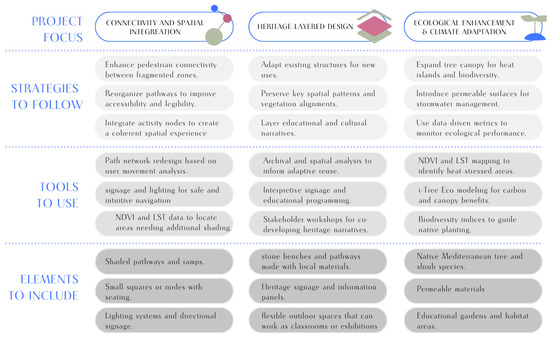
Figure 22.
The integrated framework of strategies, tools, and elements, derived from the Areos Park revitalization.
This indicates how DBR may successfully bridge theory and practice in landscape architecture [31,32,74] and is consistent with research that emphasizes collaboration and evidence-based planning in design [73].
6. Conclusions and Discussion
The redesign and revitalization of Tripoli’s Areos Park could be a valuable case study for observing and learning how nature, history, and the public interact in urban areas. This paper investigated Areos Park’s various, complex layers through the prism of a palimpsest, a potent metaphor for urban landscapes in general, presenting an urban scene formed layer upon layer of meaning and history. These historical traces are recognized and honored in architecture, resulting in a holistic urban history system that improves the neighborhood’s sense of place. Thus, this viewpoint can aid in a deeper comprehension of urban areas as dynamic environments impacted by both human and environmental factors.
Using the DBR methodology, the project investigated the strategies to direct the regeneration of urban parks in small cities while maintaining a balance between the park’s historical character and current ecological and social demands. Through the integration of repeated phases of analysis, design, and stakeholder engagement, the project illustrated how practice and research can be connected to producing solutions that are both context-specific and grounded in evidence. Additionally, the planned ecological interventions’ success was evaluated using quantitative ecological performance indicators such as NDVI, LST, and i-Tree studies, which provided measurable evidence of the project’s environmental advantages.
Therefore, this study adds to the theoretical discussion on the use of DBR in landscape architecture and urban design, and extends beyond the immediate setting of Areos Park, through the formation of a design framework that could be useful for architects, landscape architects, and urban planners, and inform similar revitalization proposals in other urban green spaces of such scale.
Although the study made valuable insights, it also pointed out significant limitations that should be considered in future interventions. Ecological and social data collection was constrained by resource restrictions, and further monitoring will be required to properly evaluate the long-term effectiveness. Moreover, the continued municipal commitment and community stewardship are also essential to its success, and maintaining them will call for constant collaboration and support. Therefore, a future plan was proposed for Areos Park that, apart from the municipality’s liabilities, focuses on the activation of environmental consciousness among the citizens. Informative signs were designed and will be placed near key plant species, detailing their history and ecological significance, and will include QR codes linking to detailed online resources that seek to establish a deeper connection between visitors and the park’s biodiversity. Finally, including artistic features into the park—such as graffiti, sculptures made from saved tree trunks, and partnerships between the municipality and local artists—will improve community involvement and add aesthetic value.
In conclusion, the design proposal for Areos Park is not an exercise in landscape design; it represents a complete proposal that prioritizes historical preservation, ecological sustainability, and community activation. The ultimate objective is to finally create long-lasting and meaningful public places that commemorate our past while at the same time contributing to a more sustainable future. While this research concentrates only on a park revitalization in a small town, ref. [31] used a similar methodological approach in the landscape design of a much broader area, the New Archaeological Museum of Cyprus, demonstrating a common dedication to incorporating historical and ecological factors into contemporary design. Areos Park’s path can then also work as an example of a larger movement to reimagine urban spaces as interconnected systems that honor the rich tapestry of human experience and nature, build a stronger common feeling of place and belonging, and, in the end, benefit the well-being of all the citizens and the ecological health of our cities.
Author Contributions
The authors contributed equally to this work. Conceptualization, J.N.T. and S.K.; methodology, J.N.T. and S.K.; software, J.N.T. and S.K.; formal analysis, J.N.T. and S.K.; investigation, J.N.T. and S.K.; resources, J.N.T. and S.K.; data curation, J.N.T. and S.K.; writing—original draft preparation, J.N.T. and S.K.; writing—review and editing, J.N.T.; visualization, J.N.T. and S.K.; supervision, J.N.T.; project administration, J.N.T.; funding acquisition, J.N.T. All authors have read and agreed to the published version of the manuscript.
Funding
This research has received funding from the European Union’s Horizon Europe under the Grant Agreement Number 101138449—MI-TRAP. The design and construction of the project Funded by programmatic agreement between Municipality of Tripoli and Parnonas S.A. for the Project “Transfer of responsibility for the preparation and implementation of the project: Actions and interventions for sustainable development of the municipality of Tripoli”, within the framework of the Development and Solidarity Program for Local Government “ANTONIS TRITSIS”.
Data Availability Statement
The original contributions presented in this study are included in the article. Further inquiries can be directed to the corresponding author(s).
Acknowledgments
The research team is beholden to the support of the local stakeholders, who participated in the interviews and provided crucial information and written material that reveal not only the history of the area, but also the current situation of the site. The in-person interviews offer a view of the unwritten insights and the sense of the place, as well as the active projects and practices in the research site area. In particular, we would like to thank the following contributors: Kostas Tzioumis, Mayor of Tripolis; Dimitris Makarounis, Vice Mayor of Education and Lifelong Learning; Marinis Beretsos, General Manager at Parnonas SA, Forest Engineer; Panagiotis Mouzakiotis, Director of Technical Department at Panonas SA, Surveyor Engineer; Evangelia Karavasia, Vice-Director of Technical Department at Panonas SA, Civil Engineer at Parnonas SA; and Dimitris Lyras, Municipal Forest Engineer. Also, we would like to thank Agrippina Deligiorgi, Civil and Traffic Engineer, Cristina Musacchio, Architect, and Nikos Thymakis, Agriculturalist, for advising the design stage and the students of MLA Ioannis Dagres for supporting the survey stage.
Conflicts of Interest
The authors declare no conflicts of interest. The funders had no role in the design of the study; in the collection, analyses, or interpretation of data; in the writing of the manuscript; or in the decision to publish the results.
References
- Chadwick, G.F. The Park and the Town; Public Landscape in the 19th and 20th Centuries; F.A. Praeger: New York, NY, USA, 1966. [Google Scholar]
- Olmsted, F. Public Parks and the Enlargement of Towns. Ciudades 2002, 7, 179–185. [Google Scholar]
- Turner, T. City as Landscape: A Post Post-Modern View of Design and Planning; Taylor & Francis: London, UK, 2014; ISBN 978-1-315-02486-8. [Google Scholar]
- Clevenger, S.M.; Andrews, D.L. Regenerating the ‘Stock’ of the Empire: Biopower and Physical Culture in English Garden City Planning Discourse, 1898–1903. Int. J. Hist. Sport 2021, 38, 282–301. [Google Scholar] [CrossRef]
- Fieldhouse, K.; Woudstra, J. (Eds.) The Regeneration of Public Parks; Taylor & Francis: London, UK, 2012; ISBN 978-0-203-85754-0. [Google Scholar]
- Cranz, G.; Boland, M. Defining the Sustainable Park: A Fifth Model for Urban Parks. Landsc. J. 2004, 23, 102–120. [Google Scholar] [CrossRef]
- Tzortzi, N.J.; Guaita, L.; Kouzoupi, A.-A. Sustainable Strategies for Urban and Landscape Regeneration Related to Agri-Cultural Heritage in the Urban-Periphery of South Milan. Sustainability 2022, 14, 6581. [Google Scholar] [CrossRef]
- Derdouri, A.; Murayama, Y.; Morimoto, T.; Wang, R.; Aghasi, N. Urban Green Space in Transition: A Cross-Continental Perspective from Eight Global North and South Cities. Landsc. Urban Plan. 2024, 253, 105220. [Google Scholar] [CrossRef]
- Sitte, C. The Art of Building Cities: City Building According to Its Artistic Fundamentals. Ravenio Books: Madison, WI, USA, 2013. [Google Scholar]
- Aram, F. Resources of Urban Green Spaces and Sustainable Development. Resources 2024, 13, 10. [Google Scholar] [CrossRef]
- Tabatabaei, S.S.; Fayaz, R. The Effect of Facade Materials and Coatings on Urban Heat Island Mitigation and Outdoor Thermal Comfort in Hot Semi-Arid Climate. Build. Environ. 2023, 243, 110701. [Google Scholar] [CrossRef]
- Apostolopoulou, D.; Tsoka, S. Climate Change and Built Environment—the Role of Urban Greenery as a Mitigation Strategy in Greek Urban Areas. IOP Conf. Ser. Earth Environ. Sci. 2021, 899, 012018. [Google Scholar] [CrossRef]
- Bühler, M.; Hollenbach, P.; Köhler, L.; Armstrong, R. Unlocking Resilience and Sustainability with Earth-Based Materials: A Principled Framework for Urban Transformation. Front. Built Environ. 2024, 10, 1385116. [Google Scholar] [CrossRef]
- Chiesura, A. The Role of Urban Parks for the Sustainable City. Landsc. Urban Plan. 2004, 68, 129–138. [Google Scholar] [CrossRef]
- Yfantidou, G.; Anthopoulos, P. Designing of Outdoor Green Recreational Parks. Theor. Empir. Res. Urban Manag. 2017, 12, 5–18. [Google Scholar]
- Arler, F. Aspects of Landscape or Nature Quality. Landsc. Ecol. 2000, 15, 291–302. [Google Scholar] [CrossRef]
- Peters, K. Being Together in Urban Parks: Connecting Public Space, Leisure, and Diversity. Leis. Sci. 2010, 32, 418–433. [Google Scholar] [CrossRef]
- Mehta, V.; Mahato, B. Designing Urban Parks for Inclusion, Equity, and Diversity. J. Urban. Int. Res. Placemaking Urban Sustain. 2020, 14, 457–489. [Google Scholar] [CrossRef]
- Cerrone, D.; López Baeza, J.; Lehtovuori, P.; Quercia, D.; Schifanella, R.; Aiello, L. Implementing Gehl’s Theory to Study Urban Space. The Case of Monotowns. Sustainability 2021, 13, 5105. [Google Scholar] [CrossRef]
- Lynch, K. Managing the Sense of a Region; MIT Press: Cambridge, MA, USA, 1976; ISBN 978-0-262-12072-2. [Google Scholar]
- Fors, H.; Hagemann, F.A.; Sang, Å.O.; Randrup, T.B. Striving for Inclusion—A Systematic Review of Long-Term Participation in Strategic Management of Urban Green Spaces. Front. Sustain. Cities 2021, 3, 572423. [Google Scholar] [CrossRef]
- Athanasiadou, E. Historic Gardens and Parks Worldwide and in Greece: Principles of Acknowledgement, Conservation, Restoration and Management. Heritage 2019, 2, 2678–2690. [Google Scholar] [CrossRef]
- Akoumianaki-Ioannidou, A.; Salta, A. Regeneration and Enhancement of the Old Railway Station Surrounding Area at Megara Athens, Greece. Acta Hortic. 2017, 1189, 161–166. [Google Scholar] [CrossRef]
- Kastanidou, S.; Katsavounidou, G. Urban Streams as Focal Points of Urban Regeneration: The Area of Konstantinidis Stream in Toumba, Thessaloniki. E3S Web Conf. 2024, 585, 09001. [Google Scholar] [CrossRef]
- Karakounos, I.; Lafargue, R.; Bomhard, K.V. Climate Responsive Urban Design for Greek Public Space-Final Project Summary, Transsolar Energietechnik GmbH Academy 2016–2017, Athens, Greece, 2017. Available online: https://transsolar.com/media/pages/approach/transsolar-academy/2017/ioannis-karakounos-greece/b597a52215-1509647105/athens_report.pdf (accessed on 16 April 2025).
- Kogia, N.; Papafotiou, M. THE GREEN LINE|A Biodiversity Corridor along the Past and Present Athens Railway Network. IOP Conf. Ser. Earth Environ. Sci. 2022, 1123, 012030. [Google Scholar] [CrossRef]
- Council of Europe. The Larissa Experiment—Nella Gollanda/Total Art Operations for the Reestablishment in Urban Life of the Wider Natural and Historical Landscape 1992-98, 2005–2006 Larissa (Town of Thessaly—Greece); Council of Europe: Strasbourg, France, 2006; Available online: https://rm.coe.int/168048d933 (accessed on 15 March 2025).
- Kjerrgren, L. Layers of Land—The Palimpsest Concept in Relation to Landscape Architecture; Swedish University of Agricultural Sciences (SLU), Department of Urban & Rural Development: Uppsala, Sweden, 2011; Available online: https://stud.epsilon.slu.se/3301/1/kjerrgren_l_111004.pdf (accessed on 3 March 2025).
- Layne, M.K. The Textual Ecology of the Palimpsest: Environmental Entanglement of Present and Past. Aisthesis Prat. Linguaggi E Saperi Dell’Estetico 2014, 7, 63–72. [Google Scholar] [CrossRef]
- Nijhuis, S.; de Vries, J. Design as Research in Landscape Architecture. Landsc. J. 2020, 38, 87–103. [Google Scholar] [CrossRef]
- Tzortzi, N.J. The Landscape Design Proposal for the New Archeological Museum of Cyprus. Land 2024, 13, 2082. [Google Scholar] [CrossRef]
- Cortesão, J.; Lenzholzer, S. Research through Design in Urban and Landscape Design Practice. J. Urban Des. 2022, 27, 617–633. [Google Scholar] [CrossRef]
- Chimona, C.; Papadopoulou, S.; Kolyva, F.; Mina, M.; Rhizopoulou, S. From Biodiversity to Musketry: Detection of Plant Diversity in Pre-Industrial Peloponnese during the Flora Graeca Expedition. Life 2022, 12, 1957. [Google Scholar] [CrossRef] [PubMed]
- Rhizopoulou, S.; Lykos, A.; Delipetrou, P.; Vallianatou, I. Living Collection of Flora Graeca Sibthorpiana: From the Folios of the Monumental Edition to the Beds of a Botanic Garden in Greece. Sibbaldia Int. J. Bot. Gard. Hortic. 2012, 10, 171–196. [Google Scholar] [CrossRef]
- Imran, H.M.; Akib, S.; Karim, M.R. Permeable Pavement and Stormwater Management Systems: A Review. Environ. Technol. 2013, 34, 2649–2656. [Google Scholar] [CrossRef] [PubMed]
- Kizos, T.; Dalaka, A.; Petanidou, T. Farmers’ Attitudes and Landscape Change: Evidence from the Abandonment of Terraced Cultivations on Lesvos, Greece. Agric. Hum. Values 2010, 27, 199–212. [Google Scholar] [CrossRef]
- Paraskeviotis, G.C. Pan’s Metapoetic Role in Vergil’s Eclogues. Eranos-Acta Philol. Suec. 2022, 113, 89–98. [Google Scholar] [CrossRef]
- Schmidt, E.A. Arkadien: Abendland Und Antike. Antike Abendl. 1975, 21, 36–57. [Google Scholar] [CrossRef]
- Virgil; Lewis, C.D.; Lyne, R.O.A.M. The Eclogues and Georgics; Oxford World’s Classics; Oxford University Press: Oxford, UK; New York, NY, USA, 2009; ISBN 978-0-19-955409-6. [Google Scholar]
- Mitsias, H.C. Tripoli 1830–2000: A Nostalgic Retrospect. Available online: https://www.politeianet.gr/el/products/9786180055207-h-xrhstos-tripolh-1830-2000-sklhrodeth-ekdosh-mia-nostalgikh-anadromh?query=1830%E2%80%932000 (accessed on 3 March 2025).
- Lack, H.W.; Mabberley, D.; Lack, H.W.; Mabberley, D. The Flora Graeca Story: Sibthorp, Bauer, and Hawkins in the Levant; Oxford University Press: Oxford, UK; New York, NY, USA, 1998; ISBN 978-0-19-854897-3. [Google Scholar]
- H Ιστορία Της Πλατείας Άρεως Aπό Το 1830 Έως Το 1980 (Photos)|Arcadia Portal. Available online: https://www.arcadiaportal.gr/news/i-istoria-tis-plateias-areos-apo-1830-eos-1980-photos (accessed on 1 July 2025).
- Stilgoe, J.R. Outside Lies Magic: Regaining History and Awareness in Everyday Places; Walker and Co.: New York, NY, USA, 1998; ISBN 978-0-8027-1340-7. [Google Scholar]
- Veldpaus, L.; Pereira Roders, A.R.; Colenbrander, B.J.F. Urban Heritage: Putting the Past into the Future. Hist. Environ. Policy Pract. 2013, 4, 3–18. [Google Scholar] [CrossRef]
- Bojanić Obad Šćitaroci, B.; Omićević, N.; Zaninović, T. Approaches to Urban Landscape Transformation vs. Heritage. Land 2024, 13, 2049. [Google Scholar] [CrossRef]
- AlSayyad, N. Hybrid Urbanism: On the Identity Discourse and the Built Environment; Bloomsbury Academic: London, UK, 2001; ISBN 978-0-275-96612-6. [Google Scholar]
- Nuryanti, W. Heritage and Postmodern Tourism. Ann. Tour. Res. 1996, 23, 249–260. [Google Scholar] [CrossRef]
- Shiflett, S.A.; Liang, L.L.; Crum, S.M.; Feyisa, G.L.; Wang, J.; Jenerette, G.D. Variation in the Urban Vegetation, Surface Temperature, Air Temperature Nexus. Sci. Total Environ. 2017, 579, 495–505. [Google Scholar] [CrossRef]
- Norton, B.A.; Coutts, A.M.; Livesley, S.J.; Harris, R.J.; Hunter, A.M.; Williams, N.S.G. Planning for Cooler Cities: A Framework to Prioritise Green Infrastructure to Mitigate High Temperatures in Urban Landscapes. Landsc. Urban Plan. 2015, 134, 127–138. [Google Scholar] [CrossRef]
- Jansson, M.; Sundevall, E.; Wales, M. The Role of Green Spaces and Their Management in a Child-Friendly Urban Village. Urban For. Urban Green. 2016, 18, 228–236. [Google Scholar] [CrossRef]
- Deming, M.; Swaffield, S. Landscape Architecture Research: Inquiry, Strategy, Design; John Wiley & Sons: Hoboken, NJ, USA, 2011. [Google Scholar]
- Braubach, M.; Egorov, A.; Mudu, P.; Wolf, T.; Ward Thompson, C.; Martuzzi, M. Effects of Urban Green Space on Environmental Health, Equity and Resilience. In Nature-Based Solutions to Climate Change Adaptation in Urban Areas: Linkages Between Science, Policy and Practice; Kabisch, N., Korn, H., Stadler, J., Bonn, A., Eds.; Springer International Publishing: Cham, Switzerland, 2017; pp. 187–205. ISBN 978-3-319-56091-5. [Google Scholar]
- Tzortzi-Georgi, N.-J.; Ioannou, D.; Oikonomaki, E. Green Corridors and Exterior Common Areas, Enhancing Connectivity in Athens, Greece. IOP Conf. Ser. Earth Environ. Sci. 2019, 296, 012002. [Google Scholar] [CrossRef]
- Dreija, K. Historic Gardens and Parks: Challenges of Development in the Context of Relevant Regulations, Definitions and Terminology. Moksl.-Liet. Ateitis Sci.-Future Lith. 2012, 4, 167–175. [Google Scholar] [CrossRef]
- Camp, J.M., II. The Athenian Agora: Excavations in the Heart of Classical Athens; Thames and Hudson: London, UK, 1986; ISBN 978-0-500-39021-4. [Google Scholar]
- Donati, J. The Greek Agora in Its Peloponnesian Context(s). In Classical Archaeology in Context: Theory and Practice in Excavation in the Greek World; Haggis, D.C., Antonaccio, C., Eds.; Walter de Gruyter: Berlin, Germany, 2015; pp. 177–218. [Google Scholar]
- Azad, D.; Barua, A.; Sultana, S. A Review Analysis of Ancient Greek Architecture. Civ. Environ. Res. 2014, 6, 94–103. [Google Scholar]
- Ballew, L. Straight and Circular in Parmenides and the “Timaeus”. Phronesis 1974, 19, 189–209. [Google Scholar] [CrossRef]
- Crouch, D. Water Management in Ancient Greek Cities; Oxford Academic: New York, NY, USA, 1993. [Google Scholar]
- Kobusch, P. 5. Fountains and Basins in Greek Sanctuaries. In The Power of Urban Water, Studies in Premodern Urbanism; De Gruyter: Berlin, Germany, 2020; pp. 69–84. ISBN 978-3-11-067706-5. [Google Scholar]
- Hamilton, R. Review of: Sympotica: A Symposium on the Symposion; Oxford University Press: Oxford, UK, 1990. [Google Scholar]
- Catalano, C.; Pasta, S.; Guarino, R. A Plant Sociological Procedure for the Ecological Design and Enhancement of Urban Green Infrastructure. In Urban Services to Ecosystems: Green Infrastructure Benefits from the Landscape to the Urban Scale; Catalano, C., Andreucci, M.B., Guarino, R., Bretzel, F., Leone, M., Pasta, S., Eds.; Springer International Publishing: Cham, Switzerland, 2021; pp. 31–60. ISBN 978-3-030-75929-2. [Google Scholar]
- Bonthoux, S.; Voisin, L.; Bouché-Pillon, S.; Chollet, S. More than Weeds: Spontaneous Vegetation in Streets as a Neglected Element of Urban Biodiversity. Landsc. Urban Plan. 2019, 185, 163–172. [Google Scholar] [CrossRef]
- Rotherham, I.D. Bio-Cultural Heritage and Biodiversity: Emerging Paradigms in Conservation and Planning. Biodivers. Conserv. 2015, 24, 3405–3429. [Google Scholar] [CrossRef]
- Berthon, K.; Thomas, F.; Bekessy, S. The Role of ‘Nativeness’ in Urban Greening to Support Animal Biodiversity. Landsc. Urban Plan. 2021, 205, 103959. [Google Scholar] [CrossRef]
- Ignatieva, M.; Meurk, C.; Stewart, G. Low Impact Urban Design and Development (LIUDD): Matching Urban Design and Urban Ecology. Landsc. Rev. 2008, 12, 61–73. [Google Scholar] [CrossRef]
- Bekessy, S. Biodiversity Sensitive Urban Design. Conserv. Lett. 2017, 11, e12411. [Google Scholar] [CrossRef]
- Missouri Botanical Garden. Plant Finder. Available online: https://www.missouribotanicalgarden.org/PlantFinder/PlantFinderSearch.aspx (accessed on 12 April 2025).
- Carlson, T.; Ripley, D. On the Relation between NDVI, Fractional Vegetation Cover, and Leaf Area Index. Remote Sens. Environ. 1997, 62, 241–252. [Google Scholar] [CrossRef]
- Tang, L.; He, M.; Li, X. Verification of Fractional Vegetation Coverage and NDVI of Desert Vegetation via UAVRS Technology. Remote Sens. 2020, 12, 1742. [Google Scholar] [CrossRef]
- Santamouris, M. Using Cool Pavements as a Mitigation Strategy to Fight Urban Heat Island—A Review of the Actual Developments. Renew. Sustain. Energy Rev. 2013, 26, 224–240. [Google Scholar] [CrossRef]
- Kreutz, A.; Derr, V.; Chawla, L. Fluid or Fixed? Processes That Facilitate or Constrain a Sense of Inclusion in Participatory Schoolyard and Park Design. Landsc. J. 2018, 37, 39–54. [Google Scholar] [CrossRef]
- Ahern, J. From Fail-Safe to Safe-to-Fail: Sustainability and Resilience in the New Urban World. Landsc. Urban Plan. 2011, 100, 341–343. [Google Scholar] [CrossRef]
- Jansson, M.; Vicenzotti, V.; Diedrich, L. Landscape Design Based on Research. A Methodological Guide to Design-Oriented Projects for Students and Teachers in Landscape Architecture. Alnarp: Faculty of Landscape Architecture, Horticulture and Crop Production Science, Swedish University of Agricultural Sciences, Report 2019:10. Available online: https://publications.slu.se/?file=publ/show&id=102088 (accessed on 3 March 2025).


Disclaimer/Publisher’s Note: The statements, opinions and data contained in all publications are solely those of the individual author(s) and contributor(s) and not of MDPI and/or the editor(s). MDPI and/or the editor(s) disclaim responsibility for any injury to people or property resulting from any ideas, methods, instructions or products referred to in the content. |
© 2025 by the authors. Licensee MDPI, Basel, Switzerland. This article is an open access article distributed under the terms and conditions of the Creative Commons Attribution (CC BY) license (https://creativecommons.org/licenses/by/4.0/).