CITI4SEA: A Typological Indicator-Based Assessment for Coastal Public Spaces in Large Euro-Mediterranean Cities
Abstract
1. Introduction
1.1. Regenerating Urban Waterfronts for Satisfying Socio-Environmental Demands
1.2. Research Background and Main Objective
- Section 1 has outlined the theoretical background, introducing the city-sea interface as a socio-ecological and spatial category;
- Section 2 presents the methodological approach, including the construction of a dataset of Euro-Mediterranean coastal cities and an evaluation grid applied to selected waterfront public spaces, in the frame of the CITI4SEA approach;
- Section 3 illustrates the results of the comparative analysis, focusing on seven major urban cases in France, Spain and Italy;
- Section 4 discusses comparative outcomes and their implications for coastal governance, with particular attention to ecological performance, functional systems, and alignment with ICZM and MSP frameworks, by proposing cross-comparisons between the various case studies identified;
- Section 5 highlights the main outputs of this contribution, providing indications on their possible applicability.
2. Methods and Materials
2.1. Geo-Database of Euro-Mediterranean Coastal Cities: The Empirical Base of the CITI4SEA Framework
- The first phase consists of identifying case studies by collecting data on Euro-Mediterranean coastal cities, which are compiled into a specific research geo-dataset.
- The second phase involves applying an evaluation grid aimed at studying the main characteristics of the coastal public spaces in the selected cities and comparing them with each other. The study identified the main coastal cities in the Euro-Mediterranean basin, considering as such urban settlements with at least 20,000 inhabitants and direct access to the sea.
- Minor cities, with a total population of less than 50,000 inhabitants;
- Medium cities, where the number of inhabitants ranges between 50,000 and 200,000;
- Large cities, ranging between 200,000 and 500,000 citizens;
- Major cities, characterised by population values of more than 500,000 inhabitants.
- Logistics and production ports, linked to shipbuilding and to the presence of coastal industrial facilities;
- Commercial ports, intended as poles characterised by container terminals and traffic
- Tourist ports, for passenger transport by ferry and high-speed boat, with the possible presence of cruise terminals;
- Leisure ports, with docks and marinas for private boats, like yachts or sailing boats.
- A resident population exceeding 500,000 inhabitants, to ensure relevance in terms of urban scale and socio-spatial complexity;
- The presence of all four identified port categories, as a proxy for maximum functional pressure exerted on the city-sea interface in terms of incoming and outgoing flows.
2.2. Evaluating Coastal Public Spaces: The Operational Structure of the CITI4SEA Framework
- The geographical extent measures in common quantitative terms the analysed area, to ensure consistency in spatial comparisons;
- The typology of uses studies each site according to a functional classification, accompanied by a study of the prevailing and often overlapping uses of these places, in order to explore the multifunctionality of the areas;
- The period and stage of implementation of the various public spaces, indicating the actual realisation of projects and contextualising them in terms of time, also in relation to broader regeneration processes;
- The equipment provision is intended assess the presence of street furniture, sanitary facilities, sports equipment, refreshment points and cultural hubs, with a score that summarises the overall density of public facilities available [52];
- The criterion of green areas examines the ecological and landscape quality by studying the degree of greenery and the complexity of existing vegetation to define a quantitative density index for comparison [53];
- The bathing areas consider both the percentage of the area intended for directly enjoying the sea and the different types of access to the water (natural beaches, artificial platforms, hybrid solutions) [54].
3. Results: Assessment of Coastal Public Spaces in French, Spanish and Italian Main Littoral Cities
3.1. Real Estate and Social-Driven Planning for Coastal Open Spaces in France: The Case of Marseille
3.2. Major Events and Local Projects for the Development of Coastal Public Space and Urban Beaches in Spain: Barcelona, Valencia, Málaga
3.2.1. The Effect of Large Events on the Open Spaces of Barcelona’s Coastal Interface
3.2.2. Reconnections Between City and Sea and Community Expectations in Valencia
3.2.3. Tourist Influence on Recreational Activities Along the Málaga City-Sea Interface
3.3. Waterfront Transformations and Static Urban Shores in Italy: Naples, Palermo and Genoa
3.3.1. Large-Scale Vision for Urban Coastal Redesign: The Immobility of the Naples Shore
3.3.2. Port-City Relations and Social Reclamation of Degraded Coastal Spaces in Palermo
3.3.3. Genoa Littoral Between Port Renewal and Socio-Economic Transformations
4. Discussion
4.1. Towards a Comparative Understanding of Coastal Public Spaces
4.1.1. Functional Assets of Coastal Public Spaces
4.1.2. Ecological Transition and Landscape Performance
4.1.3. Public Equipment Structure and Social Function
4.2. Consolidation of Clusters for Understanding Coastal Cities
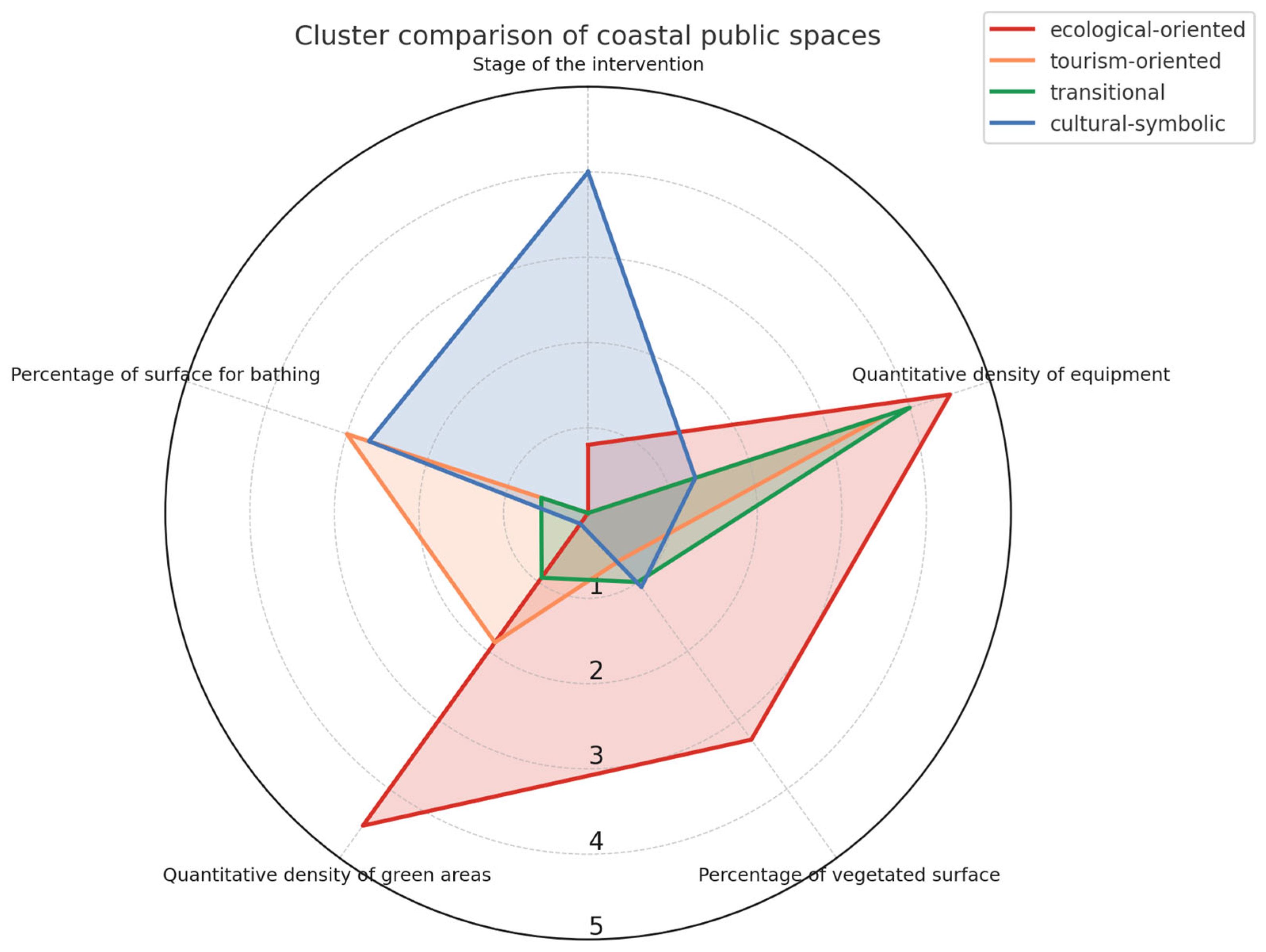
- The ecological-oriented cluster (Palermo, Genoa) shows a tendency towards green transition, and it is characterised by high vegetation levels and good ecological quality. The priority given to environmental quality reflects an approach that is still in the minority but shows promising potential.
- The tourism-oriented cluster (Malaga, Valencia) favours seaside continuity and seasonal use. Recreational facilities are highly developed, while integrating with some networks of the green infrastructure. These are high-performing models but may be socially vulnerable.
- The cultural-symbolic cluster (Barcelona, Marseille) is based on the enhancement of the urban landscape as a narrative device. However, ecological and seaside qualities remain secondary to globally oriented and institutionally shaped urban image.
- The transitional cluster (Naples) combines ambitious planning with structural fragmentation and incompleteness. Planning proceeds in separate batches, while coastal areas often remain marginal or awaiting development. The adoption of Maritime Spatial Planning tools could foster greater coherence in coastal regeneration.
4.3. Implications and Contribution to the State of the Art
- Operationalisation of the concept of habitability: While Gailing & Leibenath [27] and Erdem & Terzi [32] discuss accessibility and habitability in conceptual terms, this study provides a grounded methodological application through a comparative, indicator-based grid. This approach makes it possible to measure, compare and interpret the quality of coastal public spaces with a high degree of analytical precision.
- Temporal and spatial granularity of the analysis: Unlike large-scale comparative works (consider for instance Dal Cin et al. [31]), which focus on metropolitan adaptation strategies, this research foregrounds the micro-urban dimension of coastal public spaces, revealing internal differences even within the same city. This allows to grasp dynamics that are often overlooked by systemic analyses and to highlight the role of coastal thresholds as multifunctional devices.
- Methodological replicability and model transferability: The systematic use of median, mode, range and average to assess each dimension supports cross-context comparison while maintaining local specificity. This contributes to current debates on evaluation tools for public space, in line with the works of Dubinina et al. [32] and Jelovac [35], and provides a methodological framework potentially scalable to other European coastal contexts.
5. Conclusions
5.1. Main Outputs and Methodological Contribution
5.2. Critical Reflections on Scope and Limitations
5.3. Implications for Academics, Planners and Policymakers
- Promote multifunctional coastal public spaces that integrate ecological protection, accessibility and leisure.
- Integrate ecological corridors and vegetation into waterfront design to enhance environmental quality and climate resilience.
- Ensure inclusive and equitable access to coastal spaces, particularly in contexts undergoing transformation or regeneration.
- Use comparative assessment tools to inform strategic decisions, monitor project performance and support inter-municipal coordination.
- Address coastal planning through the urban amphibious lens, adopting functional flexibility as a design principle to support socio-ecological transition.
5.4. Future Directions and Strategic Relevance for Land-Sea Interactions
Author Contributions
Funding
Data Availability Statement
Conflicts of Interest
References
- Song, K.; Choi, Y.; Han, H.-J.; Chon, J. Adaptation and transformation planning for resilient social-ecological system in coastal wetland using spatial-temporal simulation. Sci. Total Environ. 2021, 789, 148007. [Google Scholar] [CrossRef]
- Smith, H.D.; Maes, F.; Stojanovic, T.A.; Ballinger, R.C. The integration of land and marine spatial planning. J. Coast. Conserv. 2011, 15, 291–303. [Google Scholar] [CrossRef]
- Carter, C.; Drouaud, F. Territory, ecological transition and the changing governance of ports. Territ. Politics Gov. 2022, 12, 374–394. [Google Scholar] [CrossRef]
- Kay, R.; Alder, J. Coastal Planning and Management, 2nd ed.; CRC Press: London, UK, 2005. [Google Scholar] [CrossRef]
- Cetin, M. Sustainability of urban coastal area management: A case study on Cide. J. Sustain. For. 2016, 35, 527–541. [Google Scholar] [CrossRef]
- Morales, J.A. Mitigation, Coastal Policies and Integrated Coastal Zone Management. In Coastal Geology; Morales, J.A., Ed.; Springer: Cham, Switzerland, 2022; pp. 447–455. [Google Scholar] [CrossRef]
- Ahlhorn, F. Integrated Coastal Zone Management. Status, Challenges and Prospects; Springer: Cham, Switzerland, 2018. [Google Scholar] [CrossRef]
- Iglesias-Campos, A.; Rubeck, J.; Sanmiguel-Esteban, D.; Schwarz, G. (Eds.) MSPglobal. In International Guide on Marine/Maritime Spatial Planning; UNESCO-IOC/European Commission: Paris, France, 2021. [Google Scholar]
- Calado, H.; Pegorelli, C.; Frazão Santos, C. Maritime Spatial Planning and Sustainable Development. In Encyclopedia of the UN Sustainable Development Goals; Leal Filho, W., Azul, A.M., Brandli, L., Lange Salvia, A., Wall, T., Eds.; Springer: Cham, Switzerland, 2021. [Google Scholar] [CrossRef]
- Bocci, M.; Markovic, M.; Mlakar, A.; Stancheva, M.; Borg, M.; Carella, F.; Barbanti, A.; Ramieri, E. Land-Sea-Interactions in MSP and ICZM: A regional perspective from the Mediterranean and the Black Sea. Mar. Policy 2024, 159, 105924. [Google Scholar] [CrossRef]
- Robert, S. L’urbanisation du littoral: Espaces, paysages et représentations. In Des Territoires à L’interface Ville-Mer; Université de Bretagne Occidentale (UBO): Brest, France, 2019; Available online: https://hal.science/tel-02350064v1 (accessed on 17 June 2025).
- Üzümcüoğlu, D.; Polay, M. Urban Waterfront Development, through the Lens of the Kyrenia Waterfront Case Study. Sustainability 2022, 14, 9469. [Google Scholar] [CrossRef]
- Ollivro, J. De la mer au meritoire. In Faut-il Aménager Les Océans? Editions Apogée: Rennes, France, 2016. [Google Scholar]
- Land, I. The Urban Amphibious. In The New Coastal History: Cultural and Environmental Perspectives from Scotland and Beyond; Worthington, D., Ed.; Palgrave Macmillan: Cham, Switzerland, 2017; pp. 31–48. [Google Scholar] [CrossRef]
- Marshall, R. Contemporary Urban Space-Making at the Water’s Edge. In Waterfronts in Post-Industrial Cities; Marshall, R., Ed.; Taylor & Francis: London, UK, 2001; pp. 3–14. [Google Scholar] [CrossRef]
- Hoyle, B.S. Global and Local Change on the Port-City Waterfront. Geogr. Rev. 2000, 90, 395–417. [Google Scholar] [CrossRef]
- Ritchie, R.C. Lure of the Beach: A Global History; University of California Press: Berkeley, CA, USA, 2023. [Google Scholar]
- Weissenberger, S.; Chouinard, O. (Eds.) Adaptation to Climate Change and Sea Level Rise. In The Case Study of Coastal Communities in New Brunswick, Canada; Springer: Cham, Switzerland, 2015. [Google Scholar] [CrossRef]
- Siegel, F.R. Adaptations of Coastal Cities to Global Warming, Sea Level Rise, Climate Change and Endemic Hazards; Springer: Cham, Switzerland, 2020. [Google Scholar] [CrossRef]
- Kanan, A.H.; Giupponi, C. Coastal Socio-Ecological Systems Adapting to Climate Change: A Global Overview. Sustainability 2024, 16, 10000. [Google Scholar] [CrossRef]
- Clemente, M.F.; Perney, M.; Pistone, I. Climate Change and Coastal Tourism: Vulnerabilities, Impacts and Policies in the Euro-Mediterranean Context. Sustainable Planning Perspectives in Italy and France. In Networks, Markets & People. NMP 2024. Lecture Notes in Networks and Systems; Calabrò, F., Madureira, L., Morabito, F.C., Piñeira Mantiñán, M.J., Eds.; Springer: Cham, Switzerland, 2024; pp. 83–92. [Google Scholar] [CrossRef]
- Hoskyns, T. Waterfront Public Spaces and Collective Assemblages. In Rethinking Stormwater Management Through Sustainable Urban Design; Cheshmehzangi, A., Sedrez, M., Flynn, A., Eds.; Springer: Singapore, 2024; pp. 117–131. [Google Scholar] [CrossRef]
- Vollmer, D. Urban waterfront rehabilitation: Can it contribute to environmental improvements in the developing world? Environ. Res. Lett. 2009, 4, 1–7. [Google Scholar] [CrossRef]
- Corner, J. Ecology and Landscape as Agents of Creativity. In Ecological Design and Planning; Thompson, G.F., Steiner, F.R., Eds.; Wiley: Hoboken, NJ, USA, 2006; pp. 80–108. [Google Scholar]
- Desfor, G.; Laidley, J. Reshaping Toronto’s Waterfront; University of Toronto Press: Toronto, ON, Canada, 2011. [Google Scholar] [CrossRef]
- Moretti, B. Beyond the Port City. In The Condition of Portuality and the Threshold Concept; Jovis: Berlin, Germany, 2020. [Google Scholar] [CrossRef]
- Gailing, L.; Leibenath, M. Political landscapes between manifestations and democracy, identities and power. Landsc. Res. 2017, 42, 337–348. [Google Scholar] [CrossRef]
- Anguelovski, I.; Connolly, J.J.T.; Masip, L.; Pearsall, H. Assessing green gentrification in historically disenfranchised neighborhoods: A longitudinal and spatial analysis of Barcelona. Urban. Geogr. 2018, 39, 458–491. [Google Scholar] [CrossRef]
- Swyngedouw, E. Liquid Power: Contested Hydro-Modernities in Twentieth-Century Spain; MIT Press: Cambridge, MA, USA, 2015. [Google Scholar]
- Wolch, J.; Byrne, J.; Newell, J. Urban Green Space, Public Health, and Environmental Justice: The Challenge of Making Cities ‘Just Green Enough’. Landsc. Urban. Plan. 2014, 125, 234–244. [Google Scholar] [CrossRef]
- Dal Cin, M.; Bevilacqua, C.; Calvo, R. The Urban Project as a Tool for the Adaptive and Resilient Transformation of Fragile Coastal Territories: The Case of Southern Italian Waterfronts. Water 2021, 13, 218. [Google Scholar] [CrossRef]
- Dubinina, A.; Wawrzyńska, A.; Krośnicka, K. Permeability of Waterfronts—Contemporary Approach in Designing Urban Blue Spaces. Sustainability 2022, 14, 9357. [Google Scholar] [CrossRef]
- Erdem, S.; Terzi, F. Assessing Public Space Complexity: A Comparative Study of Waterfront Areas in Istanbul’s Bosphorus District. Livenarch+ J. 2024, 1, 14–33. [Google Scholar]
- Tommarchi, E. Waterfront Redevelopment Five Decades Later: An Updated Typology and Research Agenda. Ocean. Soc. 2025, 2, 9265. [Google Scholar] [CrossRef]
- Jelovac, S.R. Towards sustainable waterfront transformation: Through the Mediterranean to Montenegro. In Sustainable Development and Planning VI, 2nd ed.; Brebbia, C.A., Ed.; WIT Press: Southampton, UK, 2013; Volume 173, pp. 37–52. [Google Scholar] [CrossRef]
- Hein, C. Port City Porosity: Boundaries, Flows, and Territories. Urban. Plan. 2021, 6, 1–9. [Google Scholar] [CrossRef]
- Meyer, H. City and Port: Transformation of Port Cities—London, Barcelona, New York and Rotterdam; International Books: Utrecht, The Netherlands, 1999. [Google Scholar]
- Schubert, D. Transformation Processes on Waterfronts in Seaport Cities—Causes and Trends between Divergence and Convergence. In Port Cities as Areas of Transition: Ethnographic Perspectives; Kokot, W., Gandelsman-Trier, M., Wildner, K., Wonneberger, A., Eds.; Transcript: Bielefeld, Germany, 2008; pp. 25–46. [Google Scholar] [CrossRef]
- Bruttomesso, R. Complexity on the Urban Waterfront. In Waterfronts in Post-Industrial Cities; Marshall, R., Ed.; Taylor & Francis: London, UK, 2001; pp. 47–58. [Google Scholar] [CrossRef]
- Vale de Paula, P.; Gonçalves, J.M. Urban Regeneration of Waterfronts: Literature Review. In Proceedings of the XV Seminario Internacional de Investigación en Urbanismo, Recife, Brazil, 4–6 September 2023; pp. 1–14. [Google Scholar] [CrossRef]
- Evans, C.; Harris, M.S.; Taufen, A.; Livesley, S.J.; Crommelin, L. What does it mean for a transitioning urban waterfront to “work” from a sustainability perspective? J. Urban. Int. Res. Placemaking Urban Sustain. 2022, 18, 349–372. [Google Scholar] [CrossRef]
- Hudson, B.J. Cities on the Shore. In The Urban Littoral Frontier; Pinter: New York, NY, USA, 1996. [Google Scholar]
- Robert, S. What can sea-related associations reveal about a coastal region’s maritimity? A case study in southern France. Marit. Stud. 2024, 23, 4. [Google Scholar] [CrossRef]
- Pistone, I. Urban Coasts in Socio-ecological Transition. A Methodological Framework to Support Planning and Management of the City-Sea Interface, 1st ed.; Springer: Cham, Switzerland, 2025. [Google Scholar] [CrossRef]
- Andrade, M.J.; Costa, J.P.; Blasco López, J. 3DPortCityMeasure: Methodology for the Comparative Study of Good Practices in Port-City Integration. Sustainability 2020, 12, 880. [Google Scholar] [CrossRef]
- Bell, S.; Fleming, L.E.; Grellier, J.; Kuhlmann, F.; Nieuwenhuijsen, M.J.; White, M.P. (Eds.) Urban Blue Spaces: Planning and Design for Water, Health and Well-Being; Routledge: London, UK, 2021. [Google Scholar] [CrossRef]
- Warnken, J.; Mosadeghi, R. Challenges of Implementing Integrated Coastal Zone Management into Local Planning Policies: A Case Study of Queensland, Australia. Mar. Policy 2018, 91, 75–84. [Google Scholar] [CrossRef]
- Pistone, I. EuroMed Coastal Cities: Comparative Dataset for Benchmarking Coastal Urban Settlements; Zenodo: Geneva, Switzerland, 2025. [Google Scholar] [CrossRef]
- Ducruet, C.; Berli, J. Measuring land-sea interactions at ports and cities: Insights from geomatics and network analysis. Portus Online 2018, 35. [Google Scholar]
- Al-Saud, L.E.; Goussous, J.S. Waterfront Urban Regeneration and Its Impact on Socio-cultural Activities (The Case of Jeddah Waterfront). In Cities’ Vocabularies and the Sustainable Development of the Silkroads; Kostopoulou, S., Herrera-Franco, G., Wood, J., Al-Kodmany, K., Eds.; Springer: Cham, Switzerland, 2023; pp. 21–32. [Google Scholar] [CrossRef]
- Mishra, H.S.; Bell, S.; Vassiljev, P.; Kuhlmann, F.; Niin, G.; Grelli, J. The development of a tool for assessing the environmental qualities of urban blue spaces. Urban For. Urban Green. 2020, 49, 126575. [Google Scholar] [CrossRef]
- Wu, X.; Liu, X. Multi-Source Data-Driven Quality Assessment of Waterfront Public Spaces. Land 2025, 14, 231. [Google Scholar] [CrossRef]
- Chávez, V.; Lithgow, D.; Losada, M.; Silva-Casarin, R. Coastal green infrastructure to mitigate coastal squeeze. J. Infrastruct. Preserv. Resil. 2021, 2, 1–12. [Google Scholar] [CrossRef]
- Barbosa de Araújo, M.C.; Ferreira da Costa, M. Environmental Quality Indicators for Recreational Beaches: Classification. J. Coast. Res. 2008, 24, 1439–1449. [Google Scholar] [CrossRef]
- INSEE—Institut National De La Statistique Et Des Etudes Economiques. Dossier complet, Commune de Marseille (13055). Available online: https://www.insee.fr/fr/statistiques/2011101?geo=COM-13055 (accessed on 15 June 2025).
- Robert, S.; Laffont-Schwob, I. Le littoral marseillais. In Marseille et L’environnement. Bilan, Qualite et Enjeux. Le Développement Durable D’une Grande Ville Littorale Face au Changement Climatique; Guiot, J., Mazurek, H., Curt, T., Raimbault, P., Eds.; Presses Universitaires de Provence: Marseille, France, 2021; pp. 147–170. [Google Scholar] [CrossRef]
- Cabioch, B.; Robert, S. Les enjeux de la gestion des plages à Marseille. Une mise en perspective avec Barcelone et Valence (Espagne). In Maritimité(s) en Région Provence-ALPES-Côte d’Azur; Bouffier, S., Robert, S., Eds.; L’atelier Méditerranéen, Presses Universitaires de Provence: Marseille, France, 2025; pp. 113–128. [Google Scholar] [CrossRef]
- MIRA—Architecture & Paysage. Plage de Pointe Rouge, Marseille. Available online: https://ateliermira.fr/index.php/portfolio-item/pointe-rouge/ (accessed on 12 June 2025).
- Grondeau, A. Durabilité, urbanité et mixité dans les opérations d’intérêt national (OIN): Les exemples d’Euroméditerranée (Marseille) et de l’Écovallée Plaine du Var (Nice). Bull. L’association Géographes Français 2023, 100. [Google Scholar] [CrossRef]
- Bergsli, H. Envisioned landscapes on Marseille’s waterfront. In Changing Places: Urbanity, Citizenship & Ideology in New European Neighbourhoods; Cremaschi, M., Eckardt, F., Eds.; Techne Press: Amsterdam, The Netherlands, 2011; pp. 34–63. [Google Scholar]
- La Ville de Marseille—Plage des Catalans. Available online: https://www.marseille.fr/mer/plages-et-baignade/plage-des-catalans (accessed on 12 June 2025).
- Musée Subaquatique de Marseille. Available online: https://www.musee-subaquatique.com/fr/ (accessed on 12 June 2025).
- INE—Instituto Nacional de Estadística. Available online: https://www.ine.es/en/index.htm (accessed on 15 June 2025).
- Blakeley, G. Local governance and local democracy: The Barcelona model. Local. Gov. Stud. 2005, 31, 149–165. [Google Scholar] [CrossRef]
- Baroghi, F.; Ribeiro, P.J.G. Olympics-related urban interventions in Barcelona and in Rio de Janeiro: A look at territorial equality legacies. Cities 2024, 155. [Google Scholar] [CrossRef]
- Degen, M. Modelar una «Nueva Barcelona»: El diseño de la vida pública. In La Metaciudad: Barcelona Transformación de Una Metrópolis; Degen, M., García, M., Eds.; Anthropos Editorial: Barcelona, Spain, 2008; pp. 83–96. [Google Scholar]
- Nofre, J.; Giordano, E.; Eldridge, A.; Martins, J.C.; Sequera, J. Tourism, nightlife and planning: Challenges and opportunities for community liveability in La Barceloneta. Tour. Geogr. 2017, 20, 377–396. [Google Scholar] [CrossRef]
- Crespi-Vallbona, M.; Mascarilla-Miró, O. La transformación y gentrificación turística del espacio urbano. El Caso De La Barceloneta (Barc.) EURE 2018, 44, 51–70. [Google Scholar] [CrossRef]
- Camerin, F. From “Ribera Plan” to “Diagonal Mar”, passing through 1992 “Vila Olímpica”. How urban renewal took place as urban regeneration in Poblenou district (Barcelona). Land Use Policy 2019, 89, 104226. [Google Scholar] [CrossRef]
- Camerin, F.; Córdoba Hernández, R. Interrogating event-induced but underused infrastructures. The white elephants of Spanish mega-events linked to the neoliberal urbanism of the recent decades. In Events and Infrastructures. Critical Interrogations; Grabher, B., Lamond, I.R., Eds.; Routledge: London, UK, 2024; pp. 22–40. [Google Scholar] [CrossRef]
- Pontes, M.; Salvador, X.; Parera, À.; Álvarez, G.; Ballesteros, M. Biodiversity in Anthropized Marinas the Case of the Barcelona Forum Bathing Area (Spain); Institució Catalana d’Història Natural: Barcelona, Spain, 2021. [Google Scholar]
- Salom, J.; Fajardo, F. Cambios recientes en la estructura territorial sociodemográfica del área metropolitana de Valencia (2001–2011). Boletín la Asoc. Geógrafos Españoles 2017, 73, 123–147. [Google Scholar] [CrossRef]
- Llavador, J.M.T. Plan de reordonacíon de la ciudad de Valencia. Proyecto Balcón al Mar—Reorganisation Plan of the City of Valencia. Balcón Al Mar. Project. Portus 2004, 8, 52–61. [Google Scholar]
- Caparrós i Gironés, P. Urban transformation on the waterfronts of Valencia and Bilbao. People Int. J. Soc. Sci. 2019, 4, 1011–1025. [Google Scholar] [CrossRef]
- Lecardane, R. Le front de mer de Valencia et l’héritage de l’America’s Cup 2007. Méditerranée. Rev. Géographique Des. Pays Méditerranéens 2008, 111, 109–114. [Google Scholar] [CrossRef]
- Martí, P.; Garcìa Mayor, C.; Melgarejo, A. Waterfront landscapes in Spanish cities: Regeneration and urban transformations. In Urban Growth and the Circular Economy; Syngellakis, S., Melgarejo, J., Eds.; WIT Press: Southampton, UK, 2018; pp. 45–56. [Google Scholar] [CrossRef]
- del Romero Renau, L.; Trudelle, C. Mega Events and Urban Conflicts in Valencia, Spain: Contesting the New Urban Modernity. Urban Stud. Res. 2011, 1. [Google Scholar] [CrossRef]
- Santamarina Campos, B.; Mompó, E. Tácticas de resistencia en la ciudad alternativas desde los movimientos urbanos en El Cabanyal (Valencia, España). AIBR Rev. De Antropol. Iberoam. 2018, 13, 381–405. [Google Scholar] [CrossRef]
- Chica-Olmo, J.; González-Morales, J.G.; Zafra-Gómez, J.L. Effects of location on Airbnb apartment pricing in Málaga. Tour. Manag. 2020, 77, 103981. [Google Scholar] [CrossRef]
- Hsu, J.R.C.; Yu, M.J.; Lee, F.C.; Benedet, L. Static bay beach concept for scientists and engineers: A review. Coast. Eng. 2010, 57, 76–91. [Google Scholar] [CrossRef]
- Royo Naranjo, M.L. Proyecto cultural Baños del Carmen: Una mirada por encima del agua. Edap Doc. Arquit. Y Patrim. 2013, 5, 20–29. [Google Scholar]
- Andrade, M.J.; Costa, J.P.; Jiménez-Morales, E.; Ruiz-Jaramillo, J. A City Profile of Málaga: The Role of the Port-City Border throughout Historical Transformations. Urban. Plan. 2021, 6, 105–118. [Google Scholar] [CrossRef]
- ISTAT—Istituto Nazionale Di Statistica. Available online: https://demo.istat.it/?l=it (accessed on 15 June 2025).
- De Martino, P. Naples: A city away from water: The role of path dependence in the history of Naples. Plan Perspect. 2023, 39, 179–194. [Google Scholar] [CrossRef]
- Salimei, G.; Pavia, R.; Di Venosa, M.; Nava, C.; E. B. S. G. Progetto di Riqualificazione urbanistica, architettonica e funzionale dell’area monumentale del porto di Napoli. Molo Beverello. 2024. Available online: https://hdl.handle.net/11573/467586 (accessed on 28 June 2025).
- Carta, M.; Ronsivalle, D. (Eds.) The Fluid City Paradigm. In Waterfront Regeneration as an Urban Renewal Strategy; Springer: Cham, Switzerland, 2016. [Google Scholar] [CrossRef]
- Gargiulo, C.; Cerrone, D. Il mare non bagna Napoli: Il lento processo di riqualificazione del waterfront. Portus Plus 2011, 1, 1–11. [Google Scholar]
- Ministero dell’Ambiente e della Sicurezza Energética—Bonifica dei siti di Interesse Nazionale. Available online: https://bonifichesiticontaminati.mite.gov.it/ (accessed on 5 June 2025).
- Coppola, E.; Crosas, C. The regeneration of the eastern area of Naples between Civic University, micro-interventions and implementation planning. In AISU. Città che si Adattano? Adaptive Cities? Tamborino, R., Ed.; AISU International: Turin, Italy, 2024; pp. 569–579. [Google Scholar]
- Coppola, E.; Sica, G. Measuring social poverty for concrete regeneration of suburbs: The Napolitan case of San Giovanni a Teduccio. UPLAND 2023, 7, 63–76. [Google Scholar] [CrossRef]
- Invitalia—Progetto Bagnoli. Un Progetto di Risanamento Ambientale e Rigenerazione Urbana Tra i Più Importanti D’europa. Available online: https://www.invitalia.it/incentivi-e-strumenti/progetto-bagnoli (accessed on 4 June 2025).
- Iacuone, S. Urban regeneration and tourist development: The case of the former industrial suburb of Bagnoli (Naples, Italy). Analele Univ. Din. Oradea Ser. Geogr. 2024, 34, 139–147. [Google Scholar] [CrossRef]
- Carta, M. Palermo Rises from the Water. PORTUS 2024, 47, 1–21. [Google Scholar]
- Carta, M. Progettare la città liquida. Il Nuovo Piano Regolatore Portuale Di Palermo. PORTUS 2018, 36, 1–11. [Google Scholar]
- Trapani, F. (Ed.) La bellezza è di tutti. In Paesaggi Costieri da Comprendere, Rigenerare e Abitare, 1st ed.; Aracne: Rome, Italy, 2020. [Google Scholar]
- Lombardini, G.; Rosasco, P. Trasformazione urbana tra convenienze private ed interessi pubblici. Il Waterfr. di Genova. Arch. di Studi Urbani E Reg. 2020, 129, 160–182. [Google Scholar] [CrossRef]
- Gastaldi, F.; Camerin, F. Progetti e proposte di Renzo Piano per il waterfront di Genova 1981–2017. Territorio 2020, 93, 147–155. [Google Scholar] [CrossRef]
- Gastaldi, F.; Camerin, F. El proceso de remodelación del waterfront de Génova y los proyectos de Renzo Piano desde los años 80 hasta el Blue Print. ACE Archit. City Environ. 2017, 11, 33–64. [Google Scholar] [CrossRef]
- Pirlone, F.; Spadaro, I.; Sabattini, M.; De Nicola, M. Sustainable urban regeneration in port-cities. A Particip. Proj. Genoa waterfront. TeMA Territ. Mobilità E Ambiente 2022, 15, 89–110. [Google Scholar] [CrossRef]
- Borelli, D.; Gaggero, T.; Pallavidino, E.; Schenone, C.; Waffo Kamdem, E.L.; Njiotang, C.A.Y. Development of a Harbour Noise Monitoring Solution within the Interreg Maritime RUMBLE Project. In Proceedings of the e-Forum Acusticum, Online, 7–11 December 2020; Université de Lyon: Lyon, France, 2020; pp. 1261–1262. [Google Scholar] [CrossRef]
- Innocenti, A.; Musco, F. Land-Sea Interactions: A Spatial Planning Perspective. Sustainability 2023, 15, 9446. [Google Scholar] [CrossRef]
- McElduff, L.; Ritchie, H. Fostering coastal community resilience: Mobilising People-Place relationships. Area 2018, 50, 186–194. [Google Scholar] [CrossRef]
- Porfyriou, H.; Sepe, M. (Eds.) Waterfronts Revisited: European Ports in a Historic and Global Perspective; Routledge: London, UK, 2016. [Google Scholar] [CrossRef]
- Luo, T.; Zhang, Z.; Hong, X.; Wang, Y.; Zhang, X. Evaluating Spatial Identity Based on Climate Adaptation in Small Cities. Int. J. Environ. Res. Public Health 2023, 20, 713. [Google Scholar] [CrossRef] [PubMed]
- Schleyer-Lindenmann, A.; Mudaliar, R.; Rishi, P.; Robert, S. Climate change and adaptation to coastal risks as perceived in two major coastal cities: An exploratory study in Marseille and Nice. Ocean. Coast. Manag. 2022, 225, 106209. [Google Scholar] [CrossRef]
- Morf, A.; Moodie, J.; Cedergren, E.; Eliasen, S.O.; Gee, K.; Kull, M.; Mahadeo, S.; Husa, S.; Vološina, M. Challenges and Enablers to Integrate Land-Sea Interactions in Cross-Border Marine and Coastal Planning: Experiences from the Pan Baltic Scope Collaboration. Plan. Pract. Res. 2022, 37, 333–354. [Google Scholar] [CrossRef]
- Zaucha, J.; Gee, K.; Ramieri, E.; Neimane, L.; Alloncle, N.; Blažauskas, N.; Calado, H.; Cervera-Núñez, C.; Marohnić Kuzmanović, V.; Stancheva, M.; et al. Implementing the EU MSP Directive: Current Status and Lessons Learned in 22 EU Member States. Mar. Policy 2025, 171, 106425. [Google Scholar] [CrossRef]
- Santos, C.; Ehler, C.; Agardy, T.; Andrade, F.; Orbach, M.; Crowder, L. Marine Spatial Planning. In World Seas: An Environmental Evaluation, 2nd ed.; Sheppard, C., Ed.; Elsevier: London, UK, 2019; Volume III, pp. 571–592. [Google Scholar] [CrossRef]

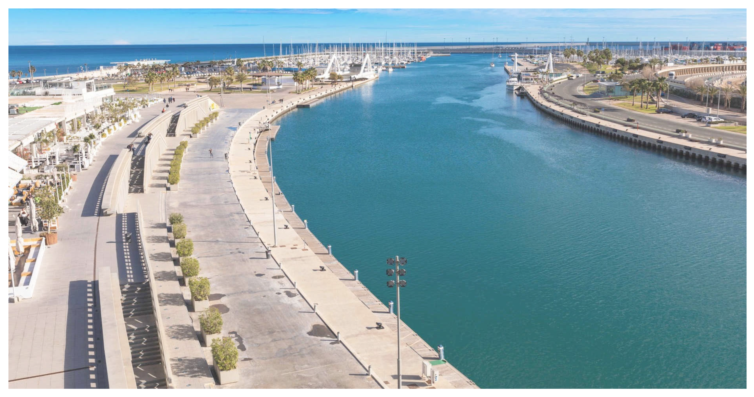
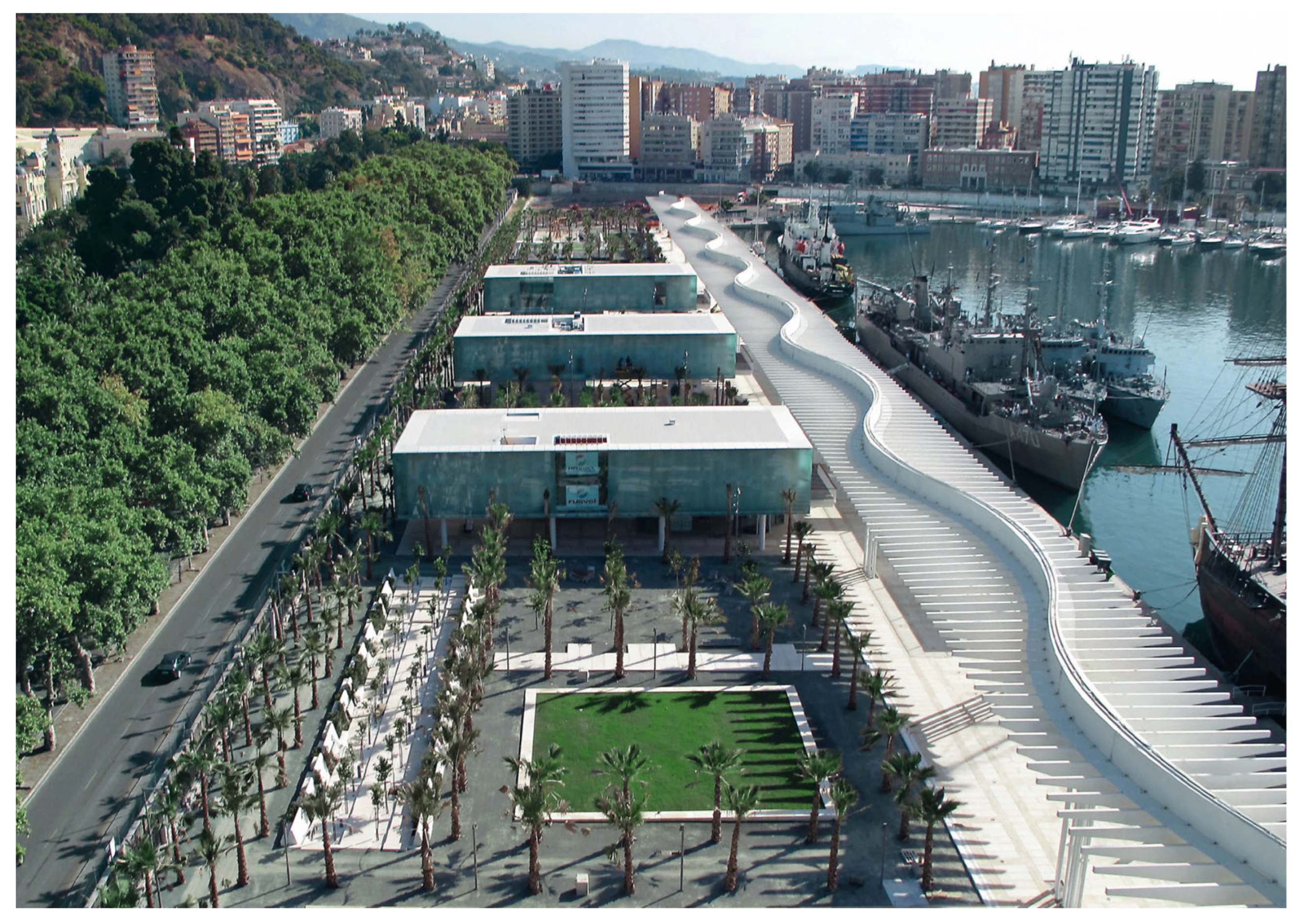

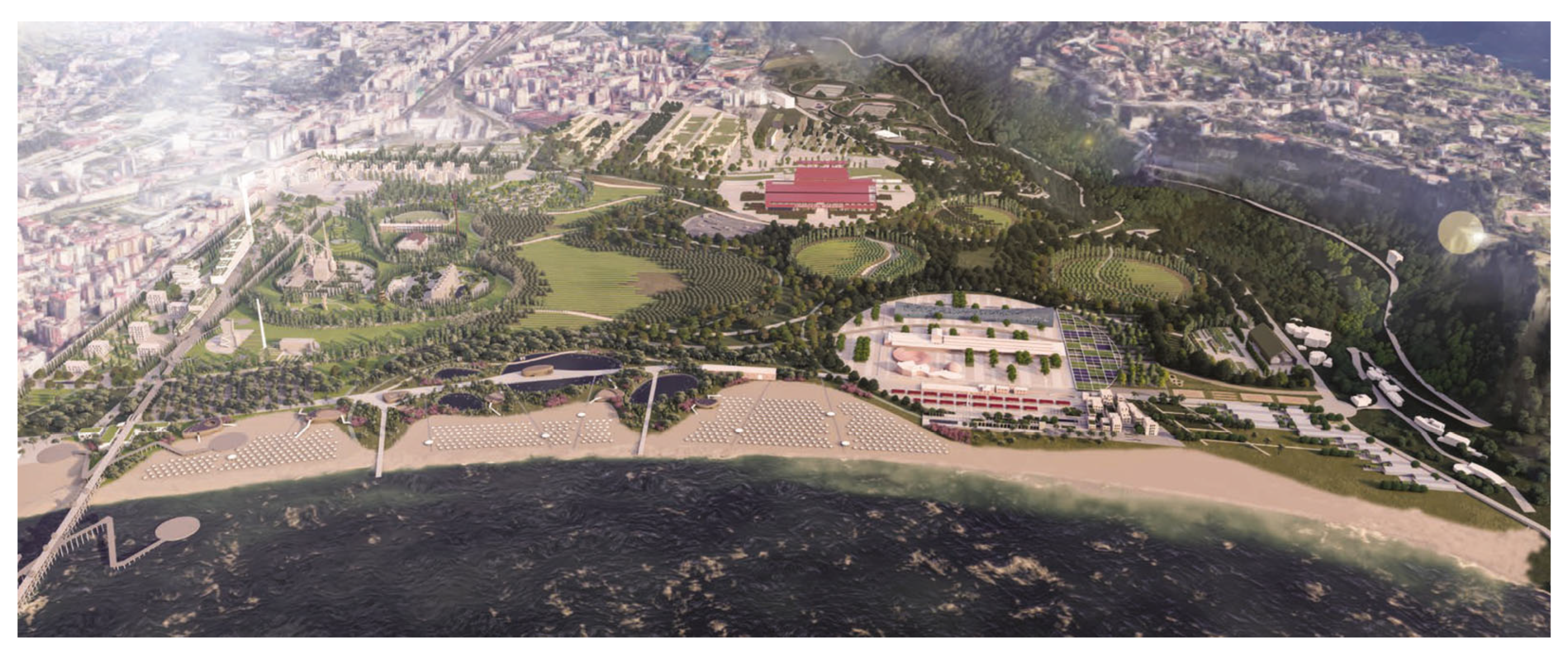
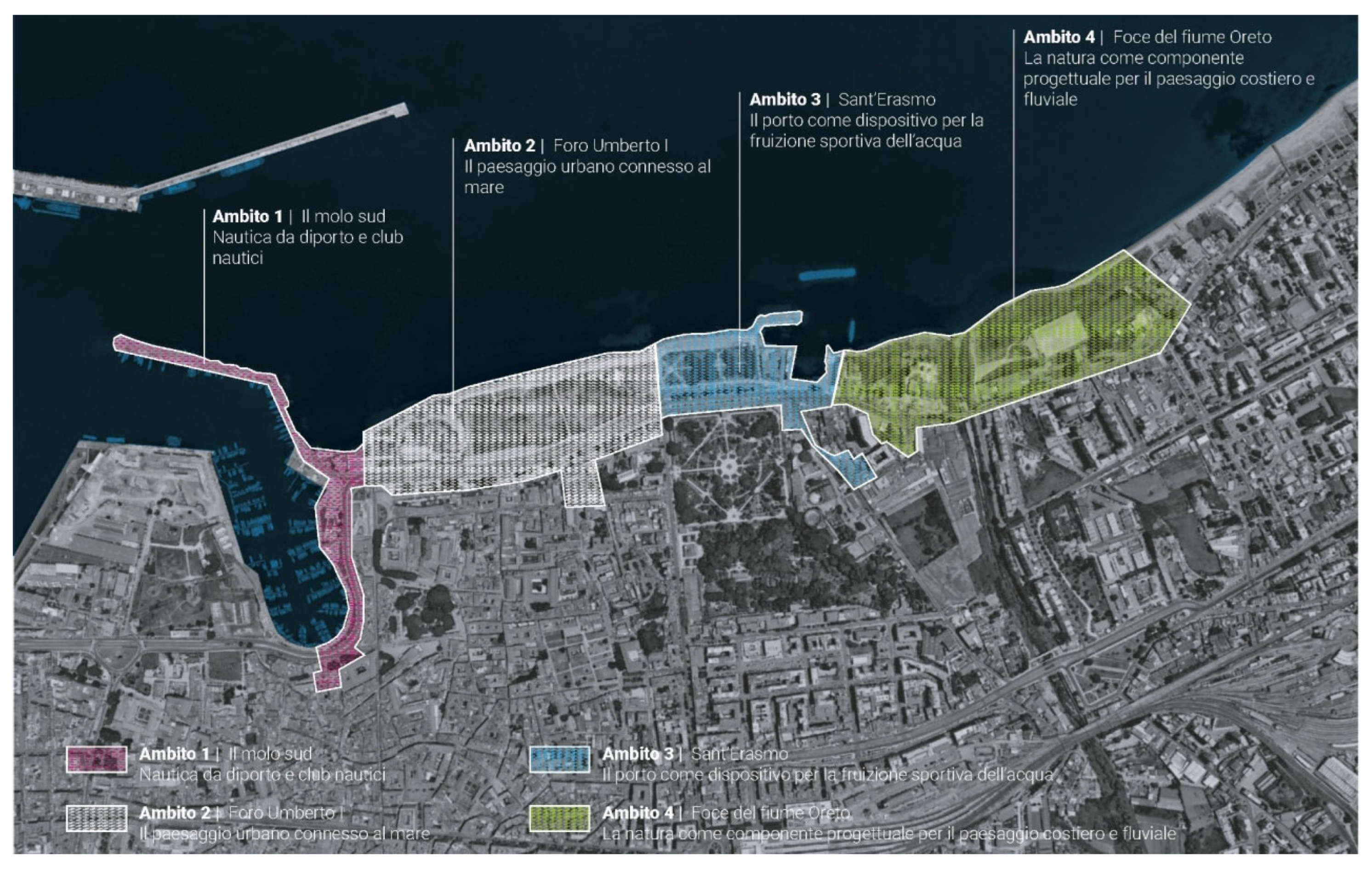


| France | Spain | Italy | Slovenia | Croatia | Greece | Cyprus | Malta | |
|---|---|---|---|---|---|---|---|---|
| Minor cities <50 k inhab. | 6 | 7 | 27 | 0 | 2 | 5 | 1 | 2 |
| Medium cities 50 k–200 k inhab. | 8 | 23 | 33 | 1 | 4 | 12 | 2 | 0 |
| Large cities 200 k–500 k inhab. | 1 | 3 | 4 | 0 | 0 | 1 | 0 | 0 |
| Major cities >500 k inhab. | 1 | 3 | 3 | 0 | 0 | 0 | 0 | 0 |
| Total | 16 | 36 | 67 | 1 | 6 | 18 | 3 | 2 |
| France | Spain | Italy | Slovenia | Croatia | Greece | Cyprus | Malta | |
|---|---|---|---|---|---|---|---|---|
| Logistic and productive ports | 7 | 10 | 19 | 1 | 2 | 6 | 1 | 0 |
| Commercial ports | 7 | 17 | 32 | 1 | 5 | 12 | 3 | 0 |
| Tourist ports | 7 | 15 | 26 | 1 | 6 | 18 | 3 | 2 |
| Leisure ports | 16 | 36 | 67 | 1 | 6 | 18 | 3 | 2 |
| Total | 37 | 78 | 144 | 4 | 19 | 54 | 10 | 4 |
| Logistic-Productive | Commercial | Tourist | Leisure | |
|---|---|---|---|---|
| Minor cities <50k inhab. | 7 | 17 | 18 | 50 |
| Medium cities 50 k–200 k inhab. | 27 | 45 | 44 | 83 |
| Large cities 200 k–500 k inhab. | 5 | 8 | 9 | 9 |
| Major cities >500k inhab. | 7 | 7 | 7 | 7 |
| Total | 46 | 77 | 78 | 149 |
| Objective | Criteria | Indicators | Expected Response |
|---|---|---|---|
| Quantify the physical extent of the analyzed area to enable spatial comparisons between case studies with respect to various parameters | Geographical extent | Total surface of the study site | value in m2 |
| Classify coastal public space according to its predominant uses, considering established or emerging functions, for typological and functional comparisons between different areas. | Typology of uses | Functional classification | Only one choice ☐ Park ☐ Beach ☐ Promenade ☐ Waterfront square ☐ Marina ☐ Harbour ☐ Other (specify) |
| Prevalent use categories | Multiple choices available ☐ Recreational ☐ Cultural ☐ Bathing ☐ Exhibition ☐ Sports ☐ Commercial ☐ Port ☐ Other (specify) | ||
| Determine the stage of implementation of the project and its timeframe in order to relate it to other urban processes or transformation dynamics | Period and stage of implementation | Stage of the intervention | Only one choice ☐ Realised ☐ Ongoing ☐ Not realised |
| Time frame for realisation | Time range or decade, if applicable | ||
| Map the presence and assess the functional diversity of facilities for public fruition, with the aim of comparing the accessibility degree to different uses of coastal public space | Equipment provision | Types of equipment found in the study area | Multiple choices available ☐ Urban furniture (benches, playgrounds, bins…) ☐ Sanitary services (toilets, showers, changing rooms…) ☐ Sports facilities (open courts, outdoor gyms…) ☐ Refreshment points (kiosks, bars, restaurants...) ☐ Cultural and recreational hubs (museums, open-air cinemas…) ☐ Other (specify) |
| Quantitative density of equipment | Sum of selected types of equipment, each worth 1 point (Range 0–5) | ||
| Evaluate the ecological and landscape quality of space through the surface and complexity of vegetated areas, in terms of environmental resilience and climate comfort. | Green areas | Percentage of vegetated surface | % (value in m2) |
| Structure of green areas | Multiple choices available ☐ Rows of trees, isolated plants ☐ Low-growing vegetation (e.g., lawn) ☐ Shrub vegetation (bushes, hedges...) ☐ Tree vegetation (e.g., groups of trees, urban woods) | ||
| Quantitative density of green areas | Sum of selected types of green areas, each worth 1 point (Range 0–3) | ||
| Assess the functional importance of bathing in relation to the entire area and identify the physical features that allow access and direct enjoyment of the sea. | Bathing areas | Percentage of surface for bathing | % (value in m2) |
| Types of bathing area | Multiple choices available ☐ Natural beach ☐ Artificial platform ☐ Mixed |
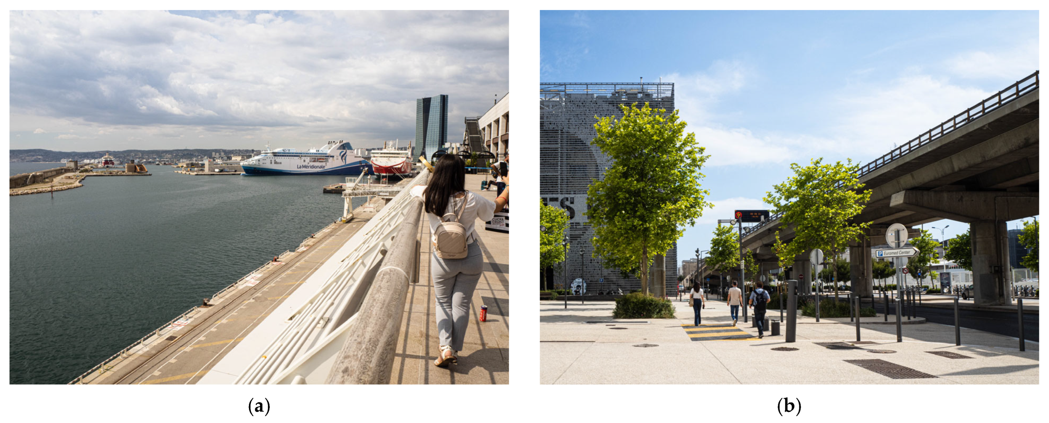
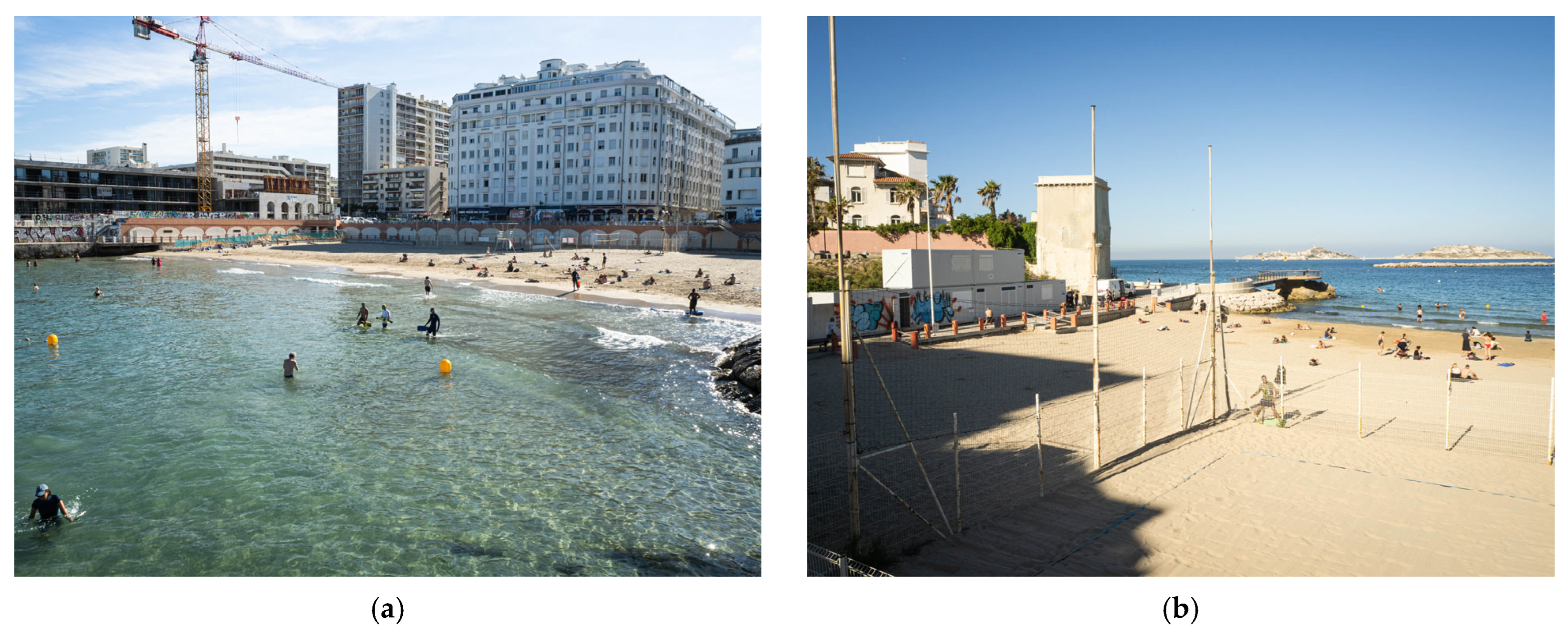
| Marseille City-Sea Interface | |||||
|---|---|---|---|---|---|
| Geographical Extent | |||||
| Total surface of the study site | Prado | Pointe Rouge | Euromed J4 pier | Catalans | Corbière |
| 400,000 m2 | 172,000 m2 | 43,500 m2 | 12,400 m2 | 22,000 m2 | |
| Typology of uses | |||||
| Functional classification | Prado | Pointe Rouge | Euromed J4 pier | Catalans | Corbière |
| Park | Marina | Square | Beach | Beach | |
| Prevalent use categories | Recreational, bathing, sports, commercial | Port, bathing, recreational | Recreational, cultural, bathing, exhibition | Bathing, sports, cultural | Bathing, sports, recreational, cultural |
| Period and stage of implementation | |||||
| Stage of the intervention | Prado | Pointe Rouge | Euromed J4 pier | Catalans | Corbière |
| Realised | Realised | Realised | Ongoing | Realised | |
| Time frame for realisation | 1970s | 2016–2020 | 2009–2013 | Started in 2020 | mid 1970s–1987 |
| Equipment provision | |||||
| Types of equipment found in the study area | Prado | Pointe Rouge | Euromed J4 pier | Catalans | Corbière |
| Urban furniture, sports facilities, refresh. points, cultural hub | Urban furniture, sanitary services, refresh. points | Urban furniture, refresh. points, cultural and recreational hub | Urban furniture, sanitary services, sports facilities, cultural hub | Urban furniture, sanitary services, sports facilities cultural hub | |
| Quantitative density of equipment | 4 | 3 | 3 | 4 | 4 |
| Green areas | |||||
| Percentage of vegetated surface | Prado | Pointe Rouge | Euromed J4 pier | Catalans | Corbière |
| 65% (260,000 m2) | 0% | 0% | 12% (1450 m2) | 45% (9800 m2) | |
| Structure of green areas | Low-growing and shrub vegetation | Not detected | Rows of trees | Low-growing vegetation | Low-growing, shrub and tree vegetation |
| Quantitative density of green areas | 2 | 0 | 1 | 1 | 3 |
| Bathing areas | |||||
| Percentage of surface for bathing | Prado | Pointe Rouge | Euromed J4 pier | Catalans | Corbière |
| 25% (100,000 m2) | 6% (10,200 m2) | 0% (not allowed) | 35% (4300 m2) | 32% (7120 m2) | |
| Types of bathing area | Natural beach | Natural beach | Artificial platform | Natural beach | Natural beach |
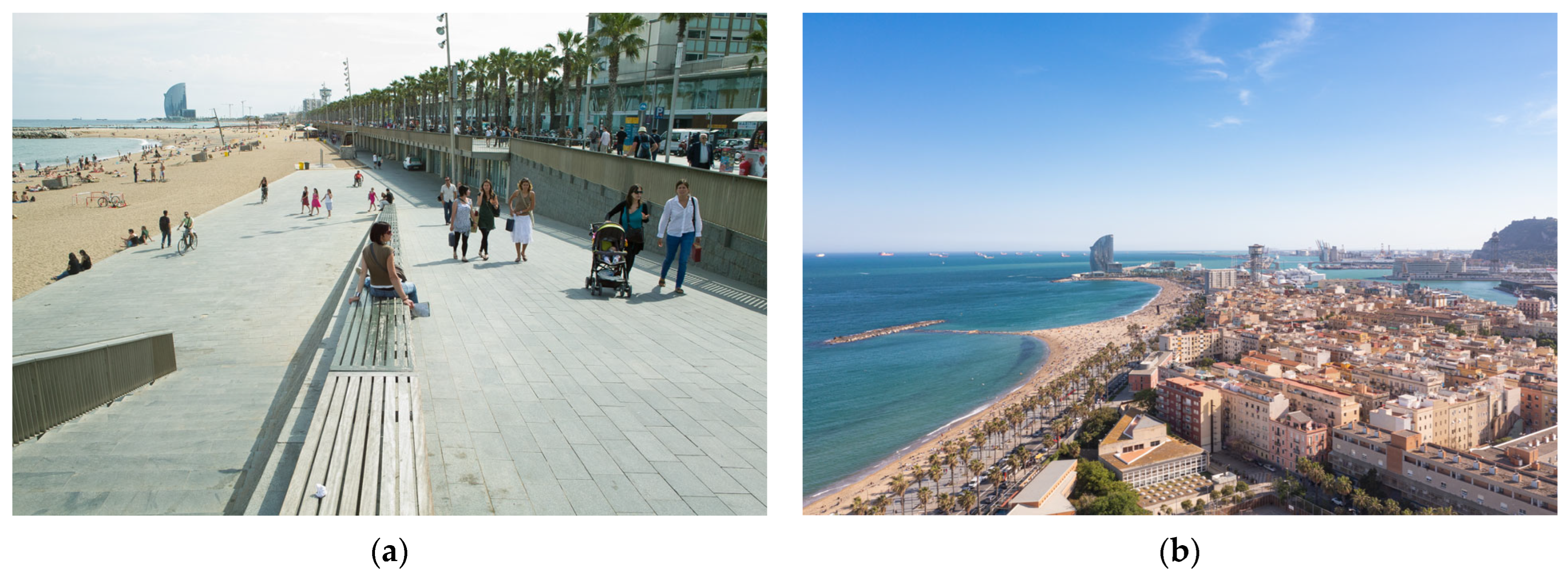
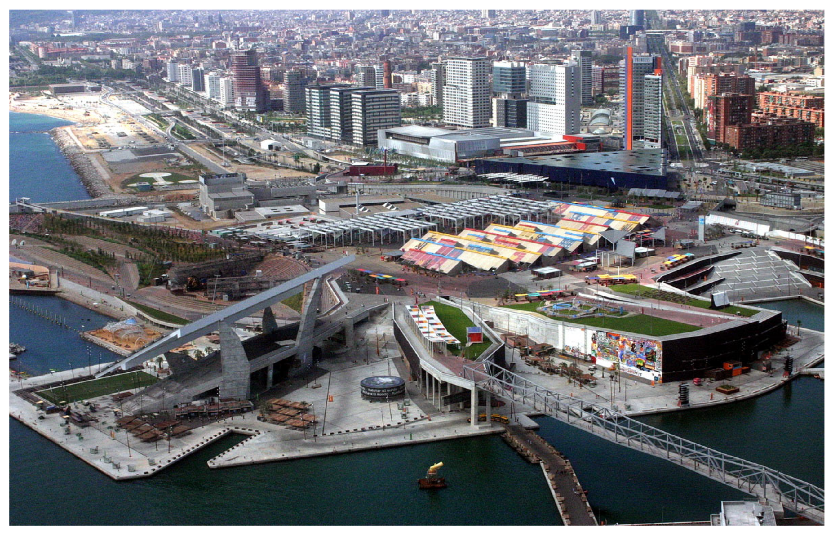
| Barcelona City-Sea Interface | ||||
|---|---|---|---|---|
| Geographical Extent | ||||
| Total surface of the study site | Barceloneta | Passeig Maritim | Diagonal Mar | Parc del Forum |
| 35,800 m2 | 97,900 m2 | 143,000 m2 | 200,000 m2 | |
| Typology of uses | ||||
| Functional classification | Barceloneta | Passeig Maritim | Diagonal Mar | Parc del Forum |
| Beach | Promenade | Park | Park | |
| Prevalent use categories | Recreational, bathing, sports | Recreational | Recreational, cultural, commercial | Recreational, cultural, exhibition, bathing, port |
| Period and stage of implementation | ||||
| Stage of the intervention | Barceloneta | Passeig Maritim | Diagonal Mar | Parc del Forum |
| Realised | Realised | Realised | Realised | |
| Time frame for realisation | 1987–1992 | 1987–1992 | 1999–2002 | 2000–2004 |
| Equipment provision | ||||
| Types of equipment found in the study area | Barceloneta | Passeig Maritim | Diagonal Mar | Parc del Forum |
| Urban furniture, sports facilities, refreshment points | Urban furniture, refreshment points | Urban furniture, cultural-recreational hubs, refresh. points | Urban furniture, refreshment points, cultural-recreational hubs | |
| Quantitative density of equipment | 3 | 2 | 3 | 3 |
| Green areas | ||||
| Percentage of vegetated surface | Barceloneta beach | Passeig Maritim | Diagonal Mar | Parc del Forum |
| 0% | 0% | 45% (65,000 m2) | 26% (52,000 m2) | |
| Structure of green areas | Not detected | Rows of trees | Low-growing, shrub and tree vegetation | Low-growing and tree vegetation |
| Quantitative density of green areas | 0 | 1 | 3 | 2 |
| Bathing areas | ||||
| Percentage of surface for bathing | Barceloneta | Passeig Maritim | Diagonal Mar | Parc del Forum |
| 90% (32,200 m2) | 0% | 0% | 6% (11,250 m2) | |
| Types of bathing area | Natural beach | Not detected | Not detected | Artificial platform |
| Valencia City-Sea Interface | ||
|---|---|---|
| Geographical Extent | ||
| Total surface of the study site | Marina Real Juan Carlos I | El Cabanyal waterfront |
| 237,000 m2 | 1,432,000 m2 | |
| Typology of uses | ||
| Functional classification | Marina Real Juan Carlos I | El Cabanyal waterfront |
| Marina | Coastal neighbourhood | |
| Prevalent use categories | Recreational, cultural, exhibition, port | Residential, commercial, recreational, cultural, bathing |
| Period and stage of implementation | ||
| Stage of the intervention | Marina Real Juan Carlos I | El Cabanyal waterfront |
| Realised | Ongoing | |
| Time frame for realisation | 2000s | Started in 2023 |
| Equipment provision | ||
| Types of equipment found in the study area | Marina Real Juan Carlos I | El Cabanyal waterfront |
| Urban furniture, refreshment points, cultural-recreational hubs, sports facilities | Urban furniture, refreshment points, cultural-recreational hubs, sports facilities | |
| Quantitative density of equipment | 4 | 4 |
| Green areas | ||
| Percentage of vegetated surface | Marina Real Juan Carlos I | El Cabanyal waterfront |
| 9% (21,700 m2) | 13% (191,000 m2) | |
| Structure of green areas | Low-growing and tree vegetation | Low-growing and tree vegetation |
| Quantitative density of green areas | 2 | 2 |
| Bathing areas | ||
| Percentage of surface for bathing | Marina Real Juan Carlos I | El Cabanyal waterfront |
| 0% | 16% (233,000 m2) | |
| Types of bathing area | Not detected | Natural beach |
| Málaga City-Sea Interface | ||||
|---|---|---|---|---|
| Geographical Extent | ||||
| Total surface of the study site | Pedralejo beach | Baños del Carmen | Palmeral Sorpresas | Parque de Málaga |
| 24,000 m2 | 4600 m2 | 26,700 m2 | 38,500 m2 | |
| Typology of uses | ||||
| Functional classification | Pedralejo beach | Baños del Carmen | Palmeral Sorpresas | Parque de Málaga |
| Beach | Beach | Square | Park | |
| Prevalent use categories | Bathing, cultural recreational | Bathing, cultural recreational | Port, recreational, cultural, exhibition | Recreational, cultural |
| Period and stage of implementation | ||||
| Stage of the intervention | Pedralejo beach | Baños del Carmen | Palmeral Sorpresas | Parque de Málaga |
| Ongoing | Ongoing | Realised | Realized | |
| Time frame for realisation | 2010–2025 (expected renovation) | Started renovation in 2025 | 2002–2011 | Renovation in 2007 (originally 1897–1921) |
| Equipment provision | ||||
| Types of equipment found in the study area | Pedralejo beach | Baños del Carmen | Palmeral Sorpresas | Parque de Málaga |
| Urban furniture, sanitary services, refreshment points, cultural-recreational hub | Urban furniture, sanitary services, sports facilities, refreshment points, cultural hub | Urban furniture, refreshment points, cultural and recreational hub | Urban furniture, refreshment points, cultural and recreational hub | |
| Quantitative density of equipment | 4 | 5 | 3 | 3 |
| Green areas | ||||
| Percentage of vegetated surface | Pedralejo beach | Baños del Carmen | Palmeral Sorpresas | Parque de Málaga |
| 0% | 9% (410 m2) | 11% (3000 m2) | 90% (35,000 m2) | |
| Structure of green areas | Isolated trees | Tree vegetation | Rows of trees, low-growing and shrub vegetation | Low-growing, shrub and tree vegetation |
| Quantitative density of green areas | 1 | 1 | 3 | 3 |
| Bathing areas | ||||
| Percentage of surface for bathing | Pedralejo beach | Baños del Carmen | Palmeral Sorpresas | Parque de Málaga |
| 100% (24,000 m2) | 60% (2750 m2) | 0% | 0% | |
| Types of bathing area | Natural beach | Natural beach | Not detected | Not detected |
| Naples City-Sea Interface | |||
|---|---|---|---|
| Geographical Extent | |||
| Total surface of the study site | Molo Beverello | Piazza Municipio | Bagnoli regeneration |
| 2400 m2 | 32,000 m2 | 240 ha | |
| Typology of uses | |||
| Functional classification | Molo Beverello | Piazza Municipio | Bagnoli regeneration |
| Marina | Square | Park | |
| Prevalent use categories | Port, recreational | Recreational, cultural, exhibition, commercial | Recreational, cultural, commercial, exhibition, port, bathing |
| Period and stage of implementation | |||
| Stage of the intervention | Molo Beverello | Piazza Municipio | Bagnoli regeneration |
| Realised | Realised | Not realised | |
| Time frame for realisation | 2018–2025 | 2011–2021 | Master plan defined in 2021 |
| Equipment provision | |||
| Types of equipment found in the study area | Molo Beverello | Piazza Municipio | Bagnoli regeneration |
| Urban furniture, sanitary services, refreshment points | Urban furniture, sanitary services, cultural and recreational hubs, refreshment points | Urban furniture, sanitary services, sports facilities, cultural and recreational hubs, refreshment points | |
| Quantitative density of equipment | 3 | 4 | 5 |
| Green areas | |||
| Percentage of vegetated surface | Molo Beverello | Piazza Municipio | Bagnoli regeneration |
| 10% (250 m2) | 0% | 60% (168 ha) | |
| Structure of green areas | Isolated plants, low-growing vegetation | Rows of trees | Low-growing, shrub and tree vegetation |
| Quantitative density of green areas | 2 | 0 | 3 |
| Bathing areas | |||
| Percentage of surface for bathing | Molo Beverello | Piazza Municipio | Bagnoli regeneration |
| 0% | 0% | 14% (33 ha) | |
| Types of bathing area | Not detected | Not detected | Mixed (not yet realized) |
| Palermo City-Sea Interface | ||
|---|---|---|
| Geographical Extent | ||
| Total surface of the study site | Palermo port waterfront | Foro Italico Umberto I |
| 535,000 m2 | 40,000 m2 | |
| Typology of uses | ||
| Functional classification | Palermo port waterfront | Foro Italico Umberto I |
| Marina | Coastal neighbourhood | |
| Prevalent use categories | Recreational, cultural, sports, commercial, port | Recreational, cultural, portbathing |
| Period and stage of implementation | ||
| Stage of the intervention | Palermo port waterfront | Foro Italico Umberto I |
| Ongoing | Realised | |
| Time frame for realisation | Started in 2018 | 1990s–2000 |
| Equipment provision | ||
| Types of equipment found in the study area | Palermo port waterfront | Foro Italico Umberto I |
| Urban furniture, sanitary services refreshment points, cultural and recreational hubs, sports facilities | Urban furniture, sanitary services, cultural-recreational hub | |
| Quantitative density of equipment | 5 | 3 |
| Green areas | ||
| Percentage of permeable surface | Palermo port waterfront | Foro Italico Umberto I |
| 55% (290,000 m2) | 90% (36,000 m2) | |
| Structure of green areas | Rows of trees, Low-growing, shrub and tree vegetation | Rows of trees/isolated plants, low-growing vegetation |
| Quantitative density of green areas | 4 | 2 |
| Bathing areas | ||
| Percentage of surface for bathing | Palermo port waterfront | Foro Italico Umberto I |
| 0% | 0% | |
| Types of bathing area | Not detected | Not detected |
| Genoa City-Sea Interface | |||
|---|---|---|---|
| Geographical Extent | |||
| Total surface of the study site | Porto Antico | Levante Waterfront | Parco Dune Genoa Prà |
| 230,000 m2 | 115,000 m2 | 40,000 m2 | |
| Typology of uses | |||
| Functional classification | Porto Antico | Levante Waterfront | Parco Dune Genoa Prà |
| Marina (historic waterfront) | Marina | Park | |
| Prevalent use categories | Recreational, cultural, exhibition, port | Recreational, cultural, commercial, port, bathing (expected in the future) | Recreational, cultural, exhibition |
| Period and stage of implementation | |||
| Stage of the intervention | Porto Antico | Levante Waterfront | Parco Dune Genoa Prà |
| Realised | Ongoing | Realised | |
| Time frame for realisation | 1992–2001 (updates in 2017) | Started in 2020 | 2021–2025 |
| Equipment provision | |||
| Types of equipment found in the study area | Porto Antico | Levante Waterfront | Parco Dune Genoa Prà |
| Urban furniture, sanitary services, sports facilities, refreshment points, cultural and recreational hubs | Urban furniture, sanitary services, refreshment points, cultural and recreational hubs | Urban furniture, sports facilities, refreshment points, cultural and recreational hubs | |
| Quantitative density of equipment | 5 | 4 | 4 |
| Green areas | |||
| Percentage of vegetated surface | Porto Antico | Levante Waterfront | Parco Dune Genoa Prà |
| 5% (11,500 m2) | 11% (13,000 m2) | 75% (30,000 m2) | |
| Structure of green areas | Rows of trees, isolated plants; low-growing vegetation | Rows of trees, low-growing vegetation, shrub vegetation | Low-growing, shrub and tree vegetation |
| Quantitative density of green areas | 2 | 3 | 3 |
| Bathing areas | |||
| Percentage of surface for bathing | Porto Antico | Levante Waterfront | Parco Dune Genoa Prà |
| 0% | 0% | 0% | |
| Types of bathing area | Not detected | Not detected (not yet realised) | Not detected |
| Marseille | Barcelona | Valencia | Malaga | Naples | Palermo | Genoa | |
|---|---|---|---|---|---|---|---|
| State | France | Spain | Spain | Spain | Italy | Italy | Italy |
| Analysed public spaces | 5 | 4 | 2 | 4 | 3 | 2 | 3 |
| Functional classification | Beach 40% | Park 25% | Marina 50%, Coastal Neighbourhood 50% | Beach 25% | Marina 33%, Square 33%, Park 33% | Marina 50%, Coastal Neighbourhood 50% | Marina 66% |
| Prevalent use categories | Bathing 80% Recreational 60% | Recreational 100% Cultural 50% Bathing 50% | Recreational 100% Cultural 100% | Cultural 100% Recreational 75% | Recreational 100% Cultural 66% | Recreational 100% Cultural 100% | Recreational 100% Cultural 100% Port 66% |
| Stage of the intervention | Realised 80% | Realised 100% | Realised 50% | Realised 50% | Realised 50% | Realised 50% | Realised 66% |
| Quantitative density of equipment | Mode 4 Median 3.6 Average 3.6 Range 3–4 | Mode 3 Median 3.6 Average 2.8 Range 3–2 | Mode 4 Median 4 Average 4 Range 4–4 | Mode 3 Median 3.5 Average 3.8 Range 5–3 | Mode amodal Median 4 Average 4 Range 5–3 | Mode amodal Median 4 Average 4 Range 5–3 | Mode 4 Median 4 Average 4.3 Range 5–4 |
| Percentage of vegetated surface | Mode 0% Median 12% Average 24.4% Range 65–0% | Mode 0% Median 13% Average 24% Range 70–0% | Mode amodal Median 11% Average 11% Range 13–9% | Mode amodal Median 10% Average 27.5% Range 90–0% | Mode 0% Median 10% Average 23.3% Range 60–0% | Mode amodal Median 72.5% Average 72.5% Range 90–55% | Mode amodal Median 11% Average 30.3% Range 75–5% |
| Quantitative density of green areas | Mode 1 Median 1 Average 1.4 Range 3–0 | Mode amodal Median 1.5 Average 1.5 Range 3–0 | Mode 2 Median 2 Average 2 Range 2–2 | Mode 1, 3 Median 2 Average 2 Range 3–1 | Mode amodal Median 2 Average 1.7 Range 3–0 | Mode amodal Median 3 Average 3 Range 4–2 | Mode 3 Median 3 Average 2.7 Range 3–2 |
| Percentage of surface for bathing | Mode 0% Median 25% Average 19.6% Range 35–0% | Mode 0% Median 3% Average 24% Range 90–0% | Mode amodal Median 8% Average 8% Range 16–0% | Mode 0% Median 30% Average 40% Range 100–0% | Mode 0% Median 0% Average 4.67% Range 14–0% | Mode 0% Median 0% Average 0% Range 0–0% | Mode 0% Median 0% Average 0% Range 0–0% |
| Types of bathing area | - Natural beach 80% - Artificial platform 20% | - Nat. beach 25% - Artificial platform 25% - Not detected 50% | - Natural beach 50% - Not detected 50% | - Natural beach 50% - Not detected 50% | - Not detected 66% - Mixed 33% | - Not detected 100% | - Not detected 100% |
| France | Spain | Italy | |
|---|---|---|---|
| Analysed cities | 1 | 3 | 3 |
| Analysed sites | 5 | 10 | 8 |
| Functional classification | Beach 20% | Beach 33%, Park 33% | Marina 50%, Park 25% |
| Prevalent use categories | Bathing 80%, Recreational 60% | Recreational 70%, Cultural 60%, Bathing 40% | Recreational 70%, Cultural 60%, Port 16% |
| Stage of the intervention | Realised 80% | Realised 66% | Realised 63% |
| Quantitative density of equipment | Mode 4 Median 3.6 Average 3.6 Range 3–4 | Mode 3 Median 3 Average 3.7 Range 5–2 | Mode 4.5 Median 4.0 Average 4.1 Range 5–3 |
| Percentage of vegetated surface | Mode 0% Median 12% Average 24.4% Range 65–0% | Mode 0%, 9% Median 10.0% Average 20.3% Range 90–0% | Mode amodal Median 33.0% Average 38.25% Range 90–0% |
| Quantitative density of green areas | Mode 1 Median 1 Average 1.4 Range 3–0 | Mode 2 Median 2 Average 2 Range 2–2 | Mode 3 Median 3.0 Average 3.25 Range 5–2 |
| Percentage of surface for bathing | Mode 0% Median 25% Average 19.6% Range 35–0% | Mode 0% Median 3.0% Average 27.2% Range 100–0% | Mode 0% Median 0.0% Average 1.75% Range 14–0% |
| Types of bathing area |
|
|
|
Disclaimer/Publisher’s Note: The statements, opinions and data contained in all publications are solely those of the individual author(s) and contributor(s) and not of MDPI and/or the editor(s). MDPI and/or the editor(s) disclaim responsibility for any injury to people or property resulting from any ideas, methods, instructions or products referred to in the content. |
© 2025 by the authors. Licensee MDPI, Basel, Switzerland. This article is an open access article distributed under the terms and conditions of the Creative Commons Attribution (CC BY) license (https://creativecommons.org/licenses/by/4.0/).
Share and Cite
Pistone, I.; Acierno, A. CITI4SEA: A Typological Indicator-Based Assessment for Coastal Public Spaces in Large Euro-Mediterranean Cities. Sustainability 2025, 17, 8239. https://doi.org/10.3390/su17188239
Pistone I, Acierno A. CITI4SEA: A Typological Indicator-Based Assessment for Coastal Public Spaces in Large Euro-Mediterranean Cities. Sustainability. 2025; 17(18):8239. https://doi.org/10.3390/su17188239
Chicago/Turabian StylePistone, Ivan, and Antonio Acierno. 2025. "CITI4SEA: A Typological Indicator-Based Assessment for Coastal Public Spaces in Large Euro-Mediterranean Cities" Sustainability 17, no. 18: 8239. https://doi.org/10.3390/su17188239
APA StylePistone, I., & Acierno, A. (2025). CITI4SEA: A Typological Indicator-Based Assessment for Coastal Public Spaces in Large Euro-Mediterranean Cities. Sustainability, 17(18), 8239. https://doi.org/10.3390/su17188239


