Abstract
This study investigates the concept of landscape services (LS), which integrate environmental and sociocultural dimensions of sustainable development. Recognizing landscapes as essential to daily life and well-being, the research aims to support sustainable spatial planning by analyzing both their potential and their actual use. The study has three main objectives: (1) to assess the potential of 16 selected landscape types to provide six key LS through expert evaluation; (2) to determine actual LS usage patterns among the local community (residents); and (3) to identify agreements and discrepancies between expert assessments and resident use. The services analyzed include providing space for daily activities; regulating spatial structure through diversity and compositional richness; enhancing physical and mental health; enabling passive and active recreation; supporting personal fulfillment; and fostering social interaction. Expert-based surveys and participatory mapping with residents were used to assess the provision and use of LS. The results indicate consistent evaluations for forest and historical urban landscapes (high potential and use) and mining and transportation landscapes (low potential and use). However, significant differences emerged for mountain LS, rated highly by experts but used minimally by residents. These insights highlight the importance of aligning expert planning with community needs to promote sustainable land use policies and reduce spatial conflicts.
1. Introduction
In recent years, the concept of landscape services (LS; provided passively by the landscape) has been proposed as an alternative or complement to the concept of ecosystem services (ES) [1,2,3,4]. LS are defined as the contributions of landscapes and landscape elements to human well-being [2], combining complementary natural and sociocultural conditions (including economics) [1]. LS are strongly related to landscape perception [5]. According to many authors, LS research is crucial for promoting sustainable development, improving quality of life, and providing actionable information for landscape management and policy making [3,6,7]. Research on LS provides valuable information for landscape planning and management, especially in urban and rural settings [8,9]. Researchers emphasize the multifunctionality of landscapes, which can provide a variety of services to people, depending on their needs [10,11,12,13]. One of the important problems addressed is assessing which type of LS is the most important or used most frequently by specific local and external social groups [10,13]. An analysis of the perception of LS can be very useful in preparing the methodology for creating spatial development plans and avoiding social conflicts resulting from differences in the perception of the importance and use of different types of local landscapes [14]. However, an interdisciplinary approach to LS that integrates ecological, economic, and social approaches is rare [15].
In this article, we contribute to the development of research on the concept of LS, which is particularly suitable for implementation in the practice of sustainable land use planning. We try to fill the knowledge gap in terms of assessing the potential of their provision by different types of landscapes and their actual relevance to the local communities (residents) of the selected municipalities and external experts. We apply the term LS as this research concerns selected landscape-type units. In our approach, the concepts of potential, demand, and use of ES are derived and applied to LS [16,17,18]. In studying the actual use of different types of landscape by residents, we use participatory mapping, which stems from an approach to landscape and spatial planning. Participatory mapping includes tools to integrate local knowledge and values into landscape and spatial analysis. They enhance inclusivity, improve decision making, and help manage conflicts in various planning contexts. Although it faces challenges and limitations, the approach holds promise for addressing complex socioenvironmental issues and promoting community engagement in landscape governance. Participatory mapping tools are used in various studies, both in the context of landscape resource conservation planning [19], land use change planning [20], landscape perception [21], or identifying conflicts in the landscape [22].
The main objective of the research is to compare the assessment of the potential for providing LS and the actual use of these services by local communities using participatory mapping of activities dedicated to the six distinguished types of LS. Specific objectives are defined as key milestones of the investigation:
- (1)
- Assessment of the potential for the delivery of LS by Polish experts in landscape research and planning based on an online survey.
- (2)
- To map activities assigned to the six main types of LS performed in different types of landscapes by local communities in six carefully selected study areas.
- (3)
- To reveal the differences between the potential and the real use of the selected LS.
The results of our research may be useful both for the development of theoretical issues in the concept of LS and for practitioners related to spatial planning because differences in the perception of the importance of LS by experts and local communities often lead to social conflicts or ineffective spatial policies.
2. Review of the Literature
The concept of LS is often confused with and used interchangeably with ES. It is important to note that there is a lack of systematization of the types of research in which these services are studied. Some researchers consider these concepts as synonyms [23], emphasizing that spatial relationships between different ecosystems are important in the analysis of LS [24]. Other researchers emphasize the differences between LS and ES [1].
The theoretical concept of ES took longer to develop. Its important achievement was to point out that natural areas, exploited and transformed by human activity for economic purposes (such as bringing profit and economic growth), also passively provide people with various types of previously underestimated services [25] that can be assessed in terms of their value, as ‘nature services’ [26,27]. This concept can be linked to older attempts to assess the value of ‘non-consumptive uses’ of land and water areas for outdoor recreation, among which the methods of ‘willingness to pay’ and ‘travel cost’ were proposed [28,29,30].
ES are defined briefly as the benefits humans obtain from ecosystems, which include provisioning, regulating, supporting, and cultural services. These services include tangible benefits such as food, water, and timber, as well as intangible benefits such as climate regulation, nutrient cycling, recreational opportunities, and satisfying other intangible human needs [31]. The concept emphasizes the critical role of ES in human well-being, highlighting the interdependence between ecological systems and human prosperity [32]. It highlights the need to integrate human factors into environmental management to ensure sustainable benefits. A significant aspect of the ES concept is the economic valuation of these services to inform policy and decision making. This approach aims to capture the full range of benefits provided by ecosystems, both direct and indirect [33].
The concept of LS is based on the concept of ES but takes into account a broader perspective related to the social dimension of the landscape and the perception of the spatial arrangement of the elements that make up the landscape, natural and anthropogenic, related to the provision of benefits for human quality of life [34]. Wu [35] highlights that LS refers to the ecological benefits generated by the configuration of individual landscape elements. LS are also defined as the social, health, and economic benefits and goods provided to society and individuals by the surrounding landscape that improve quality of life [2]. However, the concept of LS often does not focus only on the natural values of the area, such as in the initial ‘nature’s services’ concept [26], but takes into account the anthropogenic landscapes in an equivalent way. This concept is also closely related to the human perception of the landscape [36].
Bastian et al. [2] conducted a comprehensive analysis of the use of the term LS and recommended focusing on anthropogenic impacts such as the relationship between humans and their surroundings. LS analyses might broaden the perspective beyond strictly ES and place more emphasis on esthetic, cultural, or sociological aspects of the landscape. In such cases, it is advisable to use the term ‘landscape services’ instead of ‘ecosystem services’. It is important to perform these types of analyses in the context of landscape management [37]. The authors also highlight the importance of developing research methods to identify and evaluate LS. This can be achieved by combining the methods used in the ES analysis with those used in the analysis of landscape history, memory, identity, and visual values used by the cultural landscape research community [38,39]. The concept of LS is closely related to the structure, ecological processes, and functions of ecosystems [40]. The landscape structure and the landscape units are important for the delivery of LS [6]. Detailed comparisons of the concepts ES and LS have already been made in the literature, so we do not elaborate on this issue in this article and refer to existing review papers [2,24].
An important direction of research within the framework of the concepts under discussion is to assess which services are used by users of the site types in question. The key in this case is to define the possible types of landscapes and the types of services that these landscapes can provide. Evaluation of services is usually carried out within the framework of social research aimed at experts (planners, scientists) and, usually separately, at local communities (and laymen) that are users of an area with a defined landscape type.
Many authors used ‘expert surveys’ using questionnaire methods to assess ES and LS in various areas—rural, urban, and lake districts. For example, the study by Peng et al. [41] surveyed experts in hydrology, ecology, and sociology to assess the services of hydrological ecosystems in Taiwan. The findings revealed that the willingness to pay for services such as water yield and sediment export varied by discipline, highlighting the importance of interdisciplinary approaches in the valuation of ES. Schernewski et al. [42] applied expert-based evaluations in the Baltic Lagoon, integrating ES evaluations into coastal and marine planning. Experts evaluated several alternative measures (scenarios) to improve its water quality and ecological status. The study highlighted the utility of expert knowledge in regions lacking comprehensive empirical data. Elliott et al. [43] conducted workshops with experts to link urban green infrastructure with ES in New York City. The research found that larger green spaces are perceived to offer greater benefits of ES, particularly cultural services, informing urban planning strategies. Van Houtven et al. [44] combined expert elicitation with stated preference methods to evaluate ES from improved lake water quality. The study estimates a function that predicts the willingness to pay for changes in lake water quality. This study linked ecological processes with human preferences, enhancing the precision of ES valuations. Filyushkina et al. [45] evaluated the effects of landscape-level conservation strategies in forests on biodiversity and the provision of ES related to recreation and water quality. They used the Delphi technique, asking experts to complete an online survey individually in two rounds. Haara et al. [46] analyzed visual landscape sensitivity, defined as the tolerance of landscape to change, which affects visibility, recreation, and ecological sustainability, using expert judgment. Other studies focused on the visual quality of various types of landscapes. For example, Medeiros et al. [47] evaluated, using an expert protocol, the physical, esthetic, and psychophysical attributes of landscape visual quality. The aforementioned expert method captures subjective but informed perspectives on the importance of service, trade-offs, and socioecological dynamics. Key results in the most cited works include the identification of cultural and regulatory services, often undervalued in monetary approaches, as highly significant. However, the concentration of authors on ES related to green and nature areas is particularly visible, whereas a wider view on LS is rare.
Many other studies refer to evaluations of ES or LS from the point of view of the users of the land in question. This stems from the belief that, to make environmental management decisions more executive and targeted, it is essential for decision making to include local residents’ perceptions and preferences for ES. The study by Zhang et al. [48] conducted a questionnaire survey with 386 local residents to explore social perceptions of ES and biodiversity in the Fenghe River watershed. The ES analyzed contained agricultural food, livestock-derived food, fresh water, air purification, water purification, water retention, soil retention, esthetics, recreation, and spirit services. Approximately 51.3% of the respondents expressed willingness to pay for improvements to ES. Preferences varied according to personal and residential factors, highlighting the need to consider demographic heterogeneity in environmental management strategies. A comprehensive survey in 1176 households in three topographic areas in Shandong Province, China assessed satisfaction with ES [49]. The results showed varying levels of satisfaction, with cultural services receiving the highest satisfaction scores. The study demonstrated the influence of geographical and socioeconomic factors on ES perceptions. Nassauer et al. [50], through a case study in the mid-Atlantic region, evaluated public preferences for ES in exurban landscapes using various survey methods. The study found that public preferences are influenced by landscape attributes and neighborhood norms, offering information to policymakers on how ecologically designed landscapes are perceived by the broader public. This type of research even analyzed the esthetic value of underwater landscaping in lakes in Poland, through divers’ surveys [51]. Through questionnaire surveys, the study quantified visual preferences and contributed to the methodological advancement of esthetic landscape evaluations.
In the literature, there are fewer comparisons of the evaluations of the importance of ES or LS between experts involved in urban planning or academic work and local communities (or laypeople). For example, Bezák et al. [52] evaluated public preferences for ES in Slovakia, using expert-based ES matrix assessment and feedback from experts and key local stakeholders. In this research, forest areas were the most important for the delivery of ES, followed by extensive agricultural mosaics. Cultural services have the highest average supply value. Experts and local stakeholders considered that provisioning services were the most important of all ES groups due to the products available from arable land. Meng et al. [53] evaluated the sustainable development of the Tao Sichuan Creative Industry Park in China by collecting expert and public opinions on cultural LS. Using the analytical hierarchy process, the study found discrepancies between expert and public valuations, with experts prioritizing artistic value and the public emphasizing artistic, social, and economic values. Solecka et al. [54] studied landscape values in suburban areas of Wroclaw, Poland. They found that citizens assigned the highest environmental value to suburban landscapes, while experts emphasized forests and river valleys. Riechers et al. [55], investigating ES, found that both experts and laypeople in Berlin valued highly urban green spaces for their recreational benefits, although the underlying reasons differed. The experts emphasized management and ecological functions, while the residents focused on personal enjoyment and emotional connections. Although these studies did not refer to LS, they indicated differences in landscape perception by experts and residents.
The concept of landscape services (LS) has emerged as a complementary or alternative framework to ecosystem services (ES), particularly relevant for sustainable spatial planning and addressing the human dimensions of landscapes [1,23]. While ES research has traditionally focused on ecological functions and tangible benefits like provisioning and regulating services, LS highlight the interplay between natural and human-made elements, human perception, and the social, cultural, and experiential values associated with landscapes. This broader perspective allows for understanding how people engage with and assign meaning to places, moving beyond purely ecological or economic valuation. Although conceptually developed, empirical applications of the LS framework remain limited. The literature still prioritizes ES, often emphasizing natural or semi-natural areas and overlooking the perceptual and multifunctional roles of cultural and anthropogenic environments. Studies directly comparing expert assessments with community behaviors or perceptions are rare. Existing research often evaluates potential services based on expert judgment or reported resident activity but rarely integrates both. Meanwhile, participatory mapping has effectively incorporated local knowledge into planning, though primarily to identify conservation priorities, land use changes, or conflict areas, rather than to systematically assess LS perceptions across user groups.
This short review indicates that the existing literature focuses most frequently on ES, while LS remain underexplored. In addition, comparisons between the opinions of experts shaping landscape management and the actual practices of local communities are scarce. Meanwhile, top-down expert planning sometimes leads to land use conflicts between different types of stakeholders [56,57,58]. Therefore, integrating both expert and community perspectives is essential for land use planning that reflects both local and broader interests and that supports sustainable development and effective landscape governance. This study addresses these research gaps by applying an integrated framework that combines expert-based assessments of landscape service potential with participatory mapping of actual landscape use by residents in six diverse municipalities. In doing so, it contributes to the theoretical advancement of the LS concept and offers practical insights for more inclusive and responsive spatial planning.
3. Materials and Methods
3.1. The Selection of the LS Classification Used in the Study
There are several possible classifications of LS. For example, Nowak and Grunewald [59] consider three main types of services: (1) regulating (climate regulation, air quality regulation, water flow regulation, water purification, nutrient regulation, erosion regulation, pollination, pest and disease control), (2) provisioning (crop production, livestock, wild foods, timber) and (3) cultural (recreation and tourism, landscape esthetics). This division seems more related to the traditional ES approach and is less human-centered. Vallés-Planells et al. [34] have suggested another comprehensive classification of LS. The authors combine ES and LS into one classification. The main classes of services are (1) providing space for daily activities such as living, working, and commuting; (2) regulating the spatial structure by the diversity and compositional richness of natural and/or cultural elements as well as buffering disturbing use; (3) improving physical and mental health; (4) providing (passive and active) enjoyment of observing nature and/or active outdoor leisure activities; (5) providing opportunities for personal fulfillment such as improving knowledge, spiritual fulfillment, inspiration for art and culture; and (6) providing opportunities for social fulfillment with social gatherings and community integration, providing place identity and sense of belonging (Figure 1). Opdam [60] especially stresses the importance of improving human health using LS.

Figure 1.
Landscape services selected for this research. Source: author’s own graphic visualization based on the classification proposed by Vallés-Planells et al. [34].
To evaluate the use of LS by local communities (residents of the municipalities studied), we first translated the selected LS groups into specific types of activities that residents could relate to (Table 1), which were also inspired by Vallés-Planells et al. [34].

Table 1.
Relationship between landscape services (LS) and types of specific activities they represent.
3.2. The Selection of the Landscape Classification Used in the Study
The provisions of the European Landscape Convention have led to the development of many classifications and assessments of contemporary landscapes in Europe [61,62,63]. In connection with the goal of strengthening landscape protection in Poland enacted on 24 April 2015 [64] and the obligation to prepare a landscape audit at the provincial level, it was necessary to standardize the typology of landscapes in Poland. The typology of the current landscapes was created [65] based on two main groups of criteria. The first group is related to the scale of anthropogenic transformations of the landscape, and the second group is related to the dominance of specific forms of land cover and the structure and intensity of land use. Based on the adopted criteria, 3 main groups were distinguished (i.e., natural landscapes, natural–cultural landscapes, and cultural landscapes), and among them a total of 15 types and 49 subtypes of contemporary landscapes [65]. Within our study areas, 11 of the 15 types of landscapes and 20 of the 49 subtypes of landscapes were identified. The types of landscapes were surface water landscapes; swamp and meadow landscapes; forest landscapes; mountain landscapes above the forest edge; rural landscapes; mosaic landscapes; suburban and settlement landscapes; urban landscapes; metropolitan landscapes; mining landscapes; and communications landscapes.
For the purposes of the study, we modified the typology of contemporary landscapes in Poland based on Chmielewski’s work [65] so that it could be used in both the expert survey and in the survey of residents of the municipalities analyzed. The full list of our landscape types and subtypes is presented in Figure 2.
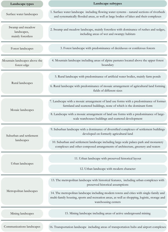
Figure 2.
Full list of landscape types and subtypes adopted for research. Source: authors’ own work.
Compared to Chmielewski’s typology, we combined some landscape subtypes, considering their similarities in form and the difficulty residents have distinguishing them. All modifications involved combining subtypes within the same landscape type to simplify classification while preserving distinctions residents could clearly recognize. As a result, in 5 of the 11 landscape types identified in the study areas (rural, mosaic, suburban and settlement, urban, and metropolitan), we limited the number of subtypes to a maximum of two and simplified their descriptions accordingly:
- Within the rural landscape, there are two subtypes: (A) rural landscape with a predominance of artificial water bodies, mainly farm ponds (related to inland fisheries) and (B) rural landscape with a predominance of a mosaic arrangement of agricultural land forming fields of different sizes (related to typical agricultural areas perceived as a whole).
- Within mosaic landscapes, there are two subtypes: (A) landscape with a mosaic arrangement of land use forms with predominance of former farmland and scattered buildings, none of which is the dominant form, and (B) landscape with a mosaic arrangement of land use forms with the predominance of large-scale warehouse buildings and scattered development.
- Within suburban and settlement landscapes: (A) Suburban and settlement landscapes with a dominance of diversified complexes of settlement buildings developed on formerly agricultural land and (B) suburban and settlement landscapes including large palace–park and monastery complexes and other composed arrangements of architecture, greenery, and waters.
- Within urban landscapes: (A) Urban landscapes with preserved historical layout (part of medium and small towns protected due to historical value included in the register of historic areas) and (B) urban landscapes with modern character (part of medium and small towns not protected due to historical value, not included in the register of historic areas). In this paper, we refer to the ‘urban landscape’ in towns without county rights.
- Within metropolitan landscapes: (A) Metropolitan landscape with historical features, including urban complexes with preserved historical assumptions (part of cities with county rights protected due to historical value included in the register of historic areas) and (B) metropolitan landscape including modern part of cities with county rights and with single- and/or multifamily housing, sports and recreation areas, as well as shopping, logistic, storage, and warehouse centers (part of city with county rights not protected due to historical value, not included in the register of historic areas).
The same landscape classification was used in both the expert survey and in the subsequent survey among residents of the municipalities analyzed.
With the additional categories, we have obtained a better reference to the different LS that exist in the region that is the subject of our research. We proposed this division based on previous research and analysis covering the region of Lower Silesia (which is the subject of our analysis), both our own [15,66,67,68] and other authors [65,69,70,71,72,73].
3.3. Study Area
For the study, we selected areas of the Lower Silesia region in Poland (Figure 3), which demonstrates a high heterogeneity of the natural and cultural landscape, resulting from the interaction of natural processes and historical human activity [69,70,74,75,76]. The natural landscape of Lower Silesia is characterized by significant morphological diversity, resulting from the location of the region at the junction of the Silesian Lowland and the Sudetes (Sudety, Sudeten) mountain range [77]. In the northern part, plain landscapes dominate, shaped primarily by fluvial and periglacial processes, with the presence of valleys of relatively large rivers (mainly the Odra River and its tributaries) and alluvial soils. However, in the southern part, there are clearly marked areas of medium mountains, the Sudetes (with the highest peak Śnieżka, 1603 m a. s. l.), with a significant role for forestry, tourism, and quarrying [78,79,80]. For LS, the geological richness of the Sudetes, associated with geological sites and old mining, is also important [81]. The cultural landscape of Lower Silesia contains elements of centuries-old land use [80], including a mosaic of arable land, green areas, forestation, and anthropogenic objects—castles, palaces, mills, historic urban layouts, and post-industrial areas [72,82,83]. Protected areas, such as two mountain national parks and numerous nature reserves, are also an important component of the landscape, reflecting the high natural and historical value of the region [84]. The currently developing agglomeration of Wrocław (the regional capital city), with an estimated population of 1.2 million [85,86], significantly affects the development of the area [87,88,89].
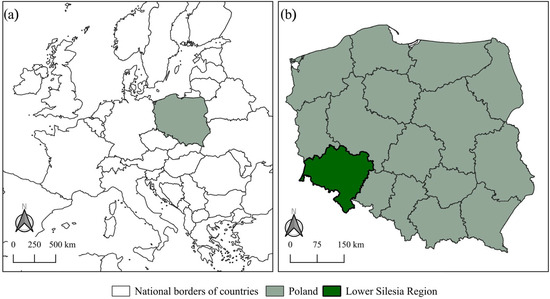
Figure 3.
Location of Poland in Europe (a) and location of Lower Silesia region in Poland (b). Source: authors’ own work.
Lower Silesia is dominated by agricultural, forest, and urban (small towns) landscapes (Figure 4). To reflect this landscape diversity and, at the same time, ensure the feasibility of the research, we selected six research areas located in different parts of Lower Silesia, representing urban, rural, and urban–rural municipalities with varying functions, including tourism, industry, and agriculture. The selection of municipalities was based on the expert judgment of our team, with key criteria including the diversity of landscape types within their boundaries. During the preliminary study, all municipalities in the Lower Silesian region were grouped into six groups: cities with county rights, municipalities located in the Wrocław suburb zone, municipalities located in mountainous areas, municipalities located in flat areas, industrial municipalities, and municipalities located entirely within protected areas. From each group in the Lower Silesian region, we selected one municipality with the highest landscape diversity. The selected areas differ in topography, land cover, and the presence of protected areas and industrial zones, reflecting a wide range of landscapes found in Poland. The study focuses on the following municipalities:
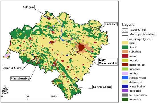
Figure 4.
Landscape types in the Lower Silesia region of Poland. The boundaries of case study municipalities are marked in black (Głogów, Krośnice, Kąty Wrocławskie, Lądek Zdrój, Mysłakowice and Jelenia Góra). Source: the authors’ own work.
- Głogów (urban and rural municipalities)—located in the Oder River valley, this mining-dominated area represents water, urban, and mining landscapes.
- Krośnice (rural municipality)—a flat agricultural and forested area with numerous ponds, located largely within the Barycz Valley Landscape Park and Natura 2000 sites; it features rural, forest, and wetland landscapes.
- Kąty Wrocławskie (urban–rural municipality)—located near Wrocław, this suburban area includes urban, rural, transportation, and forest landscapes.
- Lądek-Zdrój (urban–rural municipality)—a health resort area known for its tourist infrastructure, characterized by forest, urban, and rural landscapes.
- Mysłakowice (rural municipality)—located in the Rudawy Janowickie foothills, with palaces and parks, it includes forest, rural, suburban, and mosaic landscapes.
- Jelenia Góra (urban municipality with county rights)—situated at the foot of the Karkonosze Mountains, near the national park, the city represents a metropolitan landscape with historical and modern parts, suburban, mountain, forest, and mosaic landscapes.
3.4. Collecting and Analyzing Expert and Resident Responses
In the course of ES research, its matrix was first suggested by Burkhard et al. [90], later reloaded by Jacobs et al. [91] and further improved by Burkhard et al. [92]. We were inspired by the ES matrix when designing a questionnaire to collect opinions on the potential of different landscapes to provide services.
The collection and analysis of the data obtained was divided into three main stages. Stage 1 consisted of preparing research tools in a group of experts and residents. For the group of experts, whose task was to assess the potential of different types of landscape to provide different types of LS, a questionnaire form was prepared using the Google Forms tool. The questionnaire designed by the authors contained a definition of each of the six groups of LS and a list of 16 types of landscapes. For each of the identified landscape types, the potential to provide each of the six groups of LS had to be determined. The initial version of the questionnaire was tested with five external experts in the field, and a qualitative pretesting of the survey was conducted using a think-aloud protocol on five external respondents. This helped us improve the questionnaire in terms of user-friendly design and providing a better explanation of the terms used. To prepare the survey among residents, it was first necessary to prepare maps of municipalities divided into landscape units representing different types of landscapes. These units in each municipality were numbered so that later in the study, it would be possible to assign the places where residents perform activities to the types of landscapes in which they are performed. The interviewer received a municipality map with numbered landscape units and a list of 10 activities linked to specific LS (as shown in Table 1). With these materials, they went into the field to conduct the survey. Respondents were recruited according to the sample criteria to ensure a representative structure in terms of age and sex.
Stage 2 involved recruiting the respondents (interviewees) and collecting the data. We used a snowball sample method to reach experts [93]. We contacted researchers who were involved in landscape research, consulting, and planning services in the fields of socioeconomic geography, spatial management (including urban planning), landscape architecture and physical geography, and sociology. We used the Polish section of the International Association of Landscape Ecology Members mailing list (126 e-mail addresses) and directly contacted experts from all regions of Poland with a request to complete the survey. We also asked them to send the survey invitation to all other researchers who might be interested in filling it out, based on their research interests. Each participant could withdraw from the survey at any time without giving a reason. The University’s General Data Protection Regulation policy was followed to ensure the anonymity of responses. The responses in the expert group were collected between 18 November and 18 December 2022.
The second group of respondents was residents of the six selected case study municipalities. The survey was carried out between May and August 2023 using the Computer Assisted Personal Interview (CAPI) technique, with data collected through maps and tablets. A two-stage recruitment process was used to select participants. In the first stage, the interviewees visited 100 to 110 pre-selected addresses within each municipality. In the second stage, to achieve a representative sample structure, the interviewees moved within municipal boundaries and actively recruited additional participants who met the inclusion criteria. Eligibility for participation was limited to legal adults, defined as individuals 18 years or older under Polish law. In each municipality, the sample of respondents was proportional to the number of residents of the municipality. The age and gender structure of the respondents was kept consistent with the population structures of the municipalities surveyed that were available in the databases of Statistics Poland.
Participants received printed maps of their municipality with clearly delineated landscape types. They were asked to identify locations where they engaged in activities corresponding to various LS categories (Supplementary materials). The mapping began with residents marking their home and workplace to orient themselves and familiarize themselves with the task. If the workplace was outside the municipality, the interviewer noted this to assess whether daily activities were concentrated within the same administrative unit as the residence. Participants then marked areas where they performed activities related to five remaining LS categories. Interviewees recorded specific landscape units for each activity. Respondents could select multiple units per activity or indicate non-participation. The interviewer recorded the unit numbers on a tablet or noted if an activity was not performed.
The final stage was the analysis of the data obtained and the preparation of its visualization. The study used an expert evaluation method [4,94] based on the six-point rating scale. Respondents evaluated on a scale of 0 to 5 the potential of selected landscape types to provide six types of services, where ‘0’ meant no potential to provide a given LS, ‘1’—the weakest potential, ‘5’—the greatest potential. Rating scales are commonly used in research on psychological and medical issues such as feelings, attitudes, and individual assessment of the importance of a given trait [95]. Their disadvantage is the subjectivity of the assessment [96] and concerns related to the comparability of the assessments by various respondents. Some authors believe that these are not ratio or interval scales, but ordinal scale [97]. In this case, the statistical means used for comparative analysis are considered of limited value. The frequency distribution or statistical modes (number the most frequently indicated) are suggested to be used in analyzing the results [98,99]. With reference to these recommendations, in our article, we present the modes (Mo) and frequency (F) of the responses of the respondents, focusing on the extreme values that best differentiate the types and services.
The results of resident responses were normalized from 0 to 1 to account for differences in the number of landscape units that can be chosen in the study areas. The following normalization formula was used:
where
x—the number of times that residents indicated performing an activity in a given type of landscape unit type.
xmin—the smallest number of all indications for the same activity in a given landscape unit type.
xmax—the largest number of all indications for the same activity in a given landscape unit type.
To compare data collected by different methods, we transformed data on LS to an ordinal scale (ranks) between 1 and 16 (expert opinions by modal sum, residents’ declarations by sum of values of normalized indicators). In the case of the same sum of modal values, we used tied ranks. The highest rank (1) means that a given landscape type offers a high number of considered service types, and the lowest rank (16) means that a given landscape type offers a low number of considered services. A comparison of the ranking allowed us to assess the differences in experts’ perceptions of LS and its actual use by residents.
4. Results
4.1. Responses’ Structures
There were 617 residents of the municipalities analyzed who participated in the survey. Among the respondents, there were 52% women. The predominant respondents were those with secondary and postsecondary education (42.5%), followed by those with higher education (28.7%), basic vocational education (22.4%), and junior, primary, and lower secondary education (6.5%). The number of respondents was almost equally distributed among six municipalities. The age structure of the study group was as follows: 18–24 (8.6% of respondents), 25–34 (14.8% of respondents), 35–44 (20.1% of respondents), 45–54 (16.1% of respondents), 55–64 (16.2% of respondents), and group 65 years or older (24.3% of respondents); this was representative of the entire population of the six municipalities in this respect.
Thirty-eight respondents answered the expert questionnaire (response rate of about 30%). Among them, the largest number held the academic title of Ph.D. (55.3%), followed by the habilitated doctor (26.3%, in Poland, it is a degree between Ph.D. and full professor) and master’s degree (13.1%) and two full professors (5.3%). The experts came from all over Poland, but most came from the Lower Silesia region surveyed (34%). The experts assessed themselves as specialists in landscape ecology (20 respondents), spatial management (15), physical geography (13), socioeconomic geography (11), and landscape architecture (11), with each expert able to indicate several areas of their specialization.
Due to the limited group of experts in the field of landscape research in the country, it was impossible to collect a similar number of responses as in the case of residents. This was expected, as the expert survey was intended to evaluate the potential to provide LS by the landscape types analyzed. However, it should be noted that in our case, the response rate was similar to that in other studies using online surveys. Shih and Fan [100] reported an average response rate of 34% of online surveys, and Daikeler et al. [101] reported an average rate of 36%.
4.2. LS Potential According to Experts
Regarding the potential of assessing landscapes to provide space for daily activities, respondents most often highly rated three types of urban and metropolitan landscapes, for which the statistical mode (Mo) was the maximum value of 5 (Figure 5). The highest frequency of this evaluation (F = 47%) was attributed to a metropolitan landscape with preserved historical features, followed by urban and metropolitan landscapes of a modern character (respectively, F = 45% and F = 39). The least scoring types of landscape units to provide daily activities were swamp and pasture landscape (Mo = 0; F = 39%). This was followed by the mining landscape (Mo = 1; F = 47%) and the mountain landscape (Mo = 1; F = 39%).

Figure 5.
Potential of landscape service from experts. The figure presents the modes and their frequency based on the response scores from 1 to 5. The ranking is prepared according to the sum of the modes. Source: the authors’ own work.
Therefore, the results show that in terms of services related to daily activities, experts indicated the potential of large cities in areas with residential and commercial development, where there is usually a large number and variety of service outlets relatively easily accessible to residents. Experts noted in open comments that urban landscapes often provide a high diversity of land use within a landscape unit.
In the case of services related to the attractiveness of the view, the mountain landscape was particularly rated high (Mo = 5, 82% of the responses), followed by the type of water landscape (Mo = 5; F = 45%) and the suburban landscape and settlement, including large-scale palace and park complexes (Mo = 5; F = 34%). Relatively high scores were also given to urban and metropolitan landscapes with preserved historical layouts (both Mo = 4, with frequency of 42% and 34%, respectively). The rural landscape with a predominance of mosaic agricultural land was also highly rated (Mo = 4; F = 39%). However, the transportation landscape (Mo = 0; F = 47%) was rated the lowest, followed by the mining landscape (Mo = 1; F = 42%) and the mosaic landscape with a predominance of large-scale warehouse buildings (Mo = 1; F = 39%). However, experts commented that the mining and transportation landscape can also provide esthetic services to some people, depending on their research focus and interest.
The following landscapes were considered the most valuable for the provision of services related to improving physical and mental health (Mo = 5): forest (F = 82%), mountain (F = 79%) and surface waters (F = 61%). Extremely negative scores (Mo = 0) were given to the following landscapes: transportation (F = 76%), mining (F = 66%) and mosaic with a predominance of large-scale warehouse buildings (F = 50%). Modern urban and metropolitan landscapes were also rated relatively negatively (Mo = 1; F = 45% and 37%, respectively). It is worth noting that, compared to the ratings of the two previous categories of services, in those related to health, we observe higher frequency for the modes. This means that respondents in this category have much more aligned views than in the case of services related to daily activities and attractive views. Experts highlighted that air pollution can reduce open-air activities in the urban landscape; thus, environmental pollution undermines the potential of using urban LS in this regard.
Similar characteristics of the response distribution can be observed for outdoor entertainment. In this case, the following landscapes received the highest scores (Mo = 5): mountain (F = 89%), forest and water (both F = 84%) and swamp-meadow (F = 50%). The lowest potential for this type of service (Mo = 0), according to experts, was found in the following landscapes: transportation (F = 71%), mining (F = 61%), and mosaic landscapes with a predominance of large-scale warehouse buildings (F = 58%). Modern urban and metropolitan landscapes were rated slightly higher here (Mo = 2) than in the case of services related to improving health (Mo = 1). Similarly, slightly higher scores (Mo = 4) were obtained for the following landscapes: urban with a preserved historical layout (F = 42%), rural with a predominance of artificial water reservoirs (F = 39%) and suburban and settlement with large-area palace and park complexes (F = 34%).
According to experts, six types of landscape had the greatest potential to provide personal development and fulfillment (Mo = 5): mountain (F = 68%), forest (F = 50%); swamp and meadow (F = 45%), surface water and urban with a preserved historical layout (both F = 39%), and suburban and settlement, including large-area palace and park complexes (F = 37%). The lowest scores (Mo = 0) were obtained from the following landscapes: mosaic with a predominance of large-scale warehouse buildings and transportation (both F = 50%). Low scores (Mo = 1) were also given to the following landscapes: suburban and settlement landscapes dominated by diversified settlement complexes (F = 39%) and mining landscapes (F = 29%). Experts commented that personal fulfillment is very individual and highly dependent on interest and education.
In terms of personal development and social fulfillment, metropolitan landscapes were rated the highest (Mo = 5): both the one with preserved historical features and the one with modern character (in both cases F = 39%), followed by urban landscape of modern character (Mo = 5, F = 26). However, a high score was also given to the mountain landscape (Mo = 5, F = 29%). The urban landscape with preserved historical features (Mo = 4, F = 39%) was also highly rated. The transportation landscape (Mo = 0; F = 56%) and the mosaic landscape with a predominance of large-scale warehouse buildings (Mo = 0; F = 47%) were rated the lowest, although the potential of the following landscapes was also poorly evaluated (Mo = 1): swamps and meadows (F = 34%), mosaic with a predominance of former farmland (32%), and mining (F = 29%). In other cases, the mode values were 2 or 3.
To ensure that we considered all relevant LS in the survey, we dedicated an open question to this issue. In total, 25 of 38 experts (66%) confirmed that all relevant services have been considered. Other respondents pointed to the services related to provisioning, regulating, and maintenance (three respondents), economic services (two respondents), and marketing services (one respondent) missing in the proposed classification. Respondents understood economic services as the impact of economic aspects on perception of the landscape. Their responses were based on the assumption that socially, we are far more accepting of landscape degradation if it is necessary for significant economic benefits, e.g., a miner accepts the ugliness of a mine due to the economic benefits gained. Marketing services were understood as the building of the image and the recognition of a place through landscape elements.
4.3. LS Used by Local Communities
In factual surveys of the use of LS by local communities (residents of analyzed municipalities), they indicated on the map specific landscape units in which they used the surveyed services in carrying out their activities (Figure 6).
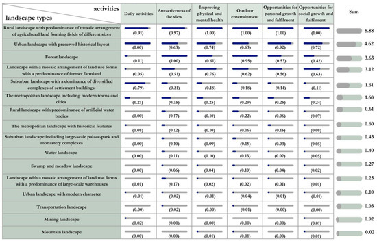
Figure 6.
The LS use by residents. A normalization of the data (where 0 indicates no indications, 1 the maximum number of indications of use of a given landscape type) was carried out, which corrects for the differing structure of the landscapes in the case studies surveyed, which influences the absolute number of respondents’ indications. The ranking is prepared according to the sum of the indicators. Source: the authors’ own work.
The results represent the frequencies of the landscape types indicated on the map, showing where the respondents engage in activities that allow them to enjoy services. Residents’ responses tend to show a concentration of activity in a few landscape types, while others are used infrequently. Daily activities are carried out mainly within an urban landscape with a historical layout, followed by a rural landscape with the predominant mosaic arrangement of agricultural land and a suburban landscape with the dominance of diversified complexes of settlement building. The attractiveness of the view is provided mainly by the forest landscape, but also by the rural landscape with the predominant mosaic arrangement of agricultural fields and the urban landscape with historical features. Actually, the responses for the rest of the considered LS are very similar. While the rural landscape provides all the services, the suburban landscape with various types of settlements is a landscape unit for daily activities and not for the rest of the identified services. The forest landscape is exactly the opposite, meaning that it provides opportunities to enjoy almost all LS excluding daily activities.
4.4. Relationship Between LS Potential and Real Use by Residents
To compare expert opinions and residents’ responses, we performed a transformation of the numerical data to an ordinal scale (ranking). For experts, the greatest potential in providing the types of services studied was mountain landscape and suburban landscape with a dominance of diversified complexes of settlement buildings (both statistical tied rank 1.5); and forest landscape, water landscape, and urban landscape with preserved historical layout (statistical tied rank 4). Experts considered landscapes with the least potential to provide LS: mining landscape, landscape with a mosaic arrangement of land use forms with a predominance of large-scale warehouses, and transportation landscape.
The local communities most often passively used the services provided by the (1) rural landscape with a predominance of mosaic arrangement of agricultural land forming fields of different sizes; (2) urban landscape with preserved historical layout; (3) forest landscape; (4) landscape with a mosaic arrangement of land use forms with a predominance of former farmland; and (5) suburban landscape with a dominance of diversified complexes of settlement buildings. The residents made the least use of the mountain landscape, mining landscape, transportation landscape, and urban landscape with modern character.
This summary indicates that in terms of high ratings, the agreement between the expert and local community’s assessment of LS occurs in the case of the high importance of forest landscape and metropolitan and urban landscapes with preserved historical layout (Table 2). Both groups of respondents also felt that relatively few services were provided by the mining and transportation landscape.
Table 2.
Potential and actual use ranks of the types of LS analyzed and differences between ranks (1—the highest rank, 16—the lowest rank).
A significant difference was identified between the experts’ ratings and the actual utilization of services in the mountainous landscape. The maximum rating assigned by experts corresponded to the minimal use of these services by residents. Similarly suburban and settlement landscape including large-scale palace–park and monastery complexes was more appreciated by experts.
High differences in evaluation are also found in the case of landscape with a mosaic arrangement of land use forms with a predominance of former farmland, suburban landscape with a dominance of diversified complexes of settlement buildings, and rural landscape with a predominance of mosaic arrangement of agricultural land forming fields of different sizes (low ratings from experts, with relatively high use of these landscape types by residents).
5. Discussion
The results of our study coincide in part with the findings of other researchers investigating ecosystem services (ES) and landscape values. Numerous authors have emphasized the important role of forests [102] and semi-natural wooded areas [103] in the delivery of ES. A broad consensus between experts and residents has often been reported on the high value of green (woodland) areas, particularly in urban fringe zones [55,104]. Similarly, Balzan et al. [103] demonstrated that semi-natural wooded areas in Malta were considered important by both experts and the public in terms of ES capacity. However, it is crucial to recognize that the types of landscape services (LS) expected from forest areas can differ between experts and residents. For example, Hofmann et al. [105] observed that while landscape planners preferred more natural areas characterized by low accessibility and high biodiversity, residents showed a stronger preference for formal parks that are designed and accessible for recreational activities. Such divergences can generate land use conflicts, particularly in ecologically valuable areas where experts aim to preserve natural qualities, while residents may seek economic opportunities through the development of tourism infrastructure.
We found a clear agreement between experts and residents about the limited provision of LS through transportation and mining landscapes. Both groups recognized that these areas offer minimal LS. However, this does not imply that transport zones are not important. Urban residents often express strong demands for the development of roads and pavements [106], even when these demands conflict with the principles of sustainability [107]. Mining activities are important for the economic development and wealth of the population. However, post-mine landscapes in their raw state contribute little, yet, when properly developed for tourism or recreation, they can acquire valuable recreational and educational functions [108].
Our analysis revealed a divergence in perceptions of mountain and suburban landscapes between experts and their use by residents. A similar pattern was observed in perception and use of rural landscapes with mosaic agricultural configurations and landscape with a mosaic arrangement of land use forms with a predominance of former farmland. Similar disjunction between expert evaluations and resident preferences has been documented in previous ES research [109]. For example, Van Zanten et al. [110] conducted a European meta-analysis and found that experts tend to prioritize natural landscapes, while residents value agricultural and rural landscapes more highly for their cultural and provisioning services. Residents tended to use the landscape units closest to their homes for outdoor socialization with family and friends. Experts favored forested, mountainous, and metropolitan landscapes for such activities. These areas may not be as frequented by residents. Vouligny et al. [111] also reported pronounced differences between expert and lay landscape assessments. The residents relied on emotional, experiential, and intimate knowledge of place, while experts employed visual and formalized criteria more similar to those used by transient visitors, such as tourists. Similarly, Solecka et al. [54] found that the correlation between expert evaluations and participatory landscape value mapping by residents in the Wroclaw suburb was limited, with few statistically significant relationships.
The observed differences between the expert assessment of LS potential and actual resident use can be attributed to several interrelated factors. Experts evaluate landscapes based on theoretical service capacity using natural, esthetic, spatial, or functional criteria. In contrast, residents rely on everyday needs, accessibility, and habits, leading to different usage patterns. Landscapes deemed to have high potential by experts may remain underused by local communities due to physical inaccessibility, legal restrictions, or lack of supportive infrastructure. Additionally, suburban or urban green areas may be used more intensively by residents simply because they are closer, safer, or more familiar, regardless of ecological or cultural value. Socioeconomic conditions also play a role, as people with limited mobility or income may have less access to distant or protected landscapes. Another aspect is perceptual divergence: residents may undervalue landscapes appreciated by experts while attaching emotional significance to areas considered marginal from a planning perspective. Lastly, methodological differences between abstract expert evaluations and resident activity-based mapping may further explain the gap. These findings underscore the need to integrate expert knowledge and local perspectives in landscape planning for more accurate and socially responsive land use strategies.
Although expert opinion can offer substantial benefits, it is essential to acknowledge its limitations. In practice, the expert method, based on surveying a small defined group, belongs to heuristic methodologies whose results cannot be generalized to the wider population. The experts were predominantly highly educated individuals of academic backgrounds, primarily located in large urban centers and university hubs. This social bias may have influenced the results, particularly since the use of landscape types often depends on the individual needs of users, which are closely related to sociocultural and demographic characteristics [106,112]. Although experts were instructed to evaluate the overall LS potential of landscapes rather than reflect personal preferences, it is nearly impossible to eliminate subjective bias in psychological evaluations of attitudes. As noted by Mocior et al. [4], the expert method is marked by a high degree of subjectivity and is significantly shaped by the environmental education of the person.
Conclusions based on a limited number of expert responses versus a larger resident sample also have limitations. Disparities in sample size and data collection methods may affect the reliability of direct comparisons. However, in this study, such limitations had only a marginal impact. Several methodological strategies were used to reduce potential bias. Ranking scales and data normalization enabled meaningful comparisons between expert assessments and resident activity, regardless of sample size. The expert panel included professionals with advanced knowledge in spatial planning, landscape architecture, and geography, ensuring informed evaluations. Given the exploratory nature of the study, statistical representativeness was not required. Thus, while the sample imbalance is acknowledged, it did not significantly undermine the study’s validity.
Another limitation concerns the number of landscape types and municipalities analyzed. For feasibility, fewer types were included to avoid overwhelming participants. Municipalities were chosen for their population size, landscape diversity, and geographic spread, though all were within one Polish province, limiting generalizability. Still, the study’s methodological framework—expert-based LS evaluation combined with participatory resident mapping—is transferable to regions with similar social and landscape characteristics. The internal diversity of the municipalities reflects conditions common in Central and Eastern Europe. Standardized typologies, normalized indicators, and ordinal data support methodological consistency and cross-regional comparisons.
This research confirms that, following the classification by Vallés-Planells et al. [34], the integration of the ES and LS matrix models appears theoretically possible but would require careful methodological consideration. The final results may not always meet the methodological rigor required for high-detail analysis [113]. Furthermore, ES approaches clearly distinguish the contributions of anthropogenic and natural ecosystems to the provision of services, allowing for more comprehensive evaluations [114]. Matrix models are increasingly popular because of their efficiency in terms of time and cost and their adaptability to diverse research goals. Although we believe LS matrices are useful for preliminary evaluations, validation through field-based indicator evaluations remains essential [115].
6. Conclusions
Our considerations lead to two groups of conclusions: theoretical, relating to the concept of landscape services, and practical, relating to land use management and planning.
In the field of theoretical considerations, we suggest several critical directions for advancing the study of LS. First, there is a clear need to refine the methodological integration of the ES and LS frameworks, especially through the use of matrix models that, while efficient, must be complemented by field-based validation to ensure robustness. Future studies should expand the geographic scope beyond a single Polish province to assess transferability and contextual variation in LS perceptions, also in major metropolitan areas where expectations and usage patterns are likely to differ from smaller or rural communities. Comparative international studies in regions with different sociocultural, ecological, and planning contexts would enrich the understanding of how LS are perceived, valued, and utilized. There is also a pressing need to explore how experiential and emotional knowledge of the place interacts with formalized expert criteria to shape landscape values. This includes investigating the impact of socioeconomic constraints, accessibility, and familiarity on LS usage. Furthermore, research should continue to explore methodological innovations in participatory approaches—such as activity-based mapping and co-design workshops—to better reflect the pluralistic nature of LS perception. Recognizing and addressing the epistemological gap between expert-based evaluations and resident experiences remains essential. In addition, future studies should also examine the long-term effects of LS-informed planning on land use, social equity, and environmental resilience to determine the effectiveness of participatory and integrative planning models in practice. Another field for future research is the use of data from social networks, in particular images depicting activities carried out in different types of landscapes, to understand human–nature interactions and the mapping of LS, especially in urban areas. This context has become increasingly popular in recent years [116]. Future studies could also apply the LS matrix to assess spatial patterns in service potential and verify them using indicator-based methodologies. Furthermore, variations in landscape use between residents and tourists warrant further investigation, as these differences could significantly affect the interpretation of LS potential [117,118].
In the field of land management and spatial planning, our study highlights the importance of integrating expert evaluations and local resident perspectives to achieve more inclusive, context-sensitive, and sustainable land use strategies. The observed differences in LS valuations between experts and residents underscore the risk of planning decisions that do not align with the use or values. Experts often prioritize ecological and material cultural heritage values, while residents base preferences on accessibility, emotional attachment, and habitual use. This mismatch can lead to conflicts, especially in ecologically sensitive areas where conservation priorities confront tourism or development pressures. Spatial planning must therefore accommodate these differing values by adopting participatory approaches that capture residents’ needs and experiences, such as participatory mapping and community engagement. Furthermore, urban and post-industrial landscapes—often undervalued in expert assessments—can be creatively repurposed to provide recreational or educational services, suggesting potential adaptive reuse in spatial planning. Transport zones, though low in LS provision, remain important due to their infrastructural and economic functions, and their redevelopment can contribute to more balanced urban planning. Our study also suggests a need for planning mosaic landscapes near residential zones, i.e., areas consisting of a variety of landscape types that together offer multiple LS. Other studies also highlight the value of mosaic landscapes in delivering diverse ES [103,110]. Urban land use planning should aim to incorporate or preserve green and wooded areas, complemented by aquatic features, such as rivers and ponds, within built environments [119]. However, balancing economic interests with nature conservation goals continues to pose challenges, even in systems of multi-stakeholder negotiation [120,121].
In summary, our research offers valuable insights into the complex relationship between expert evaluations and local interactions with landscapes. By identifying both points of convergence and divergence, this study reinforces the need to integrate diverse stakeholder perspectives into effective and equitable landscape planning and evaluation of LS.
Supplementary Materials
The original survey and its translation, databases, and all modeling results and appendices to this paper are available in the OSF repository by Center for Open Science under the following link: https://osf.io/phx78/?view_only=e2832f25f88e4800bbabb0ecd85ab770 (accessed on 31 of July 2025).
Author Contributions
Conceptualization, P.K., M.F., M.S., I.K. and M.L.; methodology, P.K., M.F., M.S., I.K. and M.L.; software, P.K. and M.S.; validation P.K. and M.S.; formal analysis, M.S. and M.F.; data curation, P.K.; writing—original draft preparation, P.K., M.F. and M.S.; writing—review and editing, P.K. and M.F.; visualization, M.L.; supervision, P.K.; project administration, P.K.; funding acquisition, P.K. Estimated Percentage Engagement, P.K. 25%, M.F. 25%, M.S. 25%, I.K. 15% and M.L. 10%. All authors have read and agreed to the published version of the manuscript.
Funding
This study was supported by the National Science Center, Poland, project number: 2018/31/D/HS4/00659. The APC was funded by MDPI within the framework of a ‘Feature Paper’ action—an individual invitation from the editors.
Institutional Review Board Statement
Ethical review and approval were waived for this study. According to Article 37a(1) of the Polish Act of 5 December 1996 on the Professions of Physician and Dentist (Journal of Laws 2021, item 790, as amended), ethical committee approval is mandatory for medical experiments involving human participants. This definition does not cover non-invasive, anonymous social science research such as surveys or questionnaires that do not collect sensitive personal data and do not involve interventions or vulnerable populations. Furthermore, the Act of 10 May 2018 on the Protection of Personal Data (Journal of Laws 2019, item 1781), which implements the GDPR in Poland, allows for the collection of anonymous data without requiring specific ethical approval, provided that participants cannot be identified and no sensitive data (as defined under Article 9 of the GDPR) is processed. In line with national academic practice and the guidelines of the Polish National Science Centre (NCN), ethics committee approval is not required for anonymous, voluntary surveys that pose minimal or no risk to participants.
Informed Consent Statement
All participants were fully informed whether their anonymity was assured, why the research was being conducted, and how their data would be used. Participation in the survey was voluntary, and each participant was informed about the full scope of the survey. All participants received a printed copy of the information clause regarding the protection of personal data.
Data Availability Statement
The original survey and databases are available in Supplementary Materials.
Acknowledgments
The authors hereby declare that they used generative artificial intelligence tools during the preparation of the manuscript. They used the language models DeepL and Writefull for Word (versions active on May 2025) for the following purpose: English translations and corrections. They used SCOPUS AI (version active on May 2025) and Scholar Pro GPT version 4o for the following purpose: to find additional items of scientific literature in the SCOPUS and Google Scholar databases. The authors then carried out a thorough and critical review of the proposed items, with particular attention to potential false, incomplete or biased information, possible plagiarism, or lack of proper/accurate authorship attribution, and revised it accordingly.
Conflicts of Interest
The authors declare that they have no conflicts of interest.
Abbreviations
The following abbreviations are used in this manuscript:
| LS | Landscape services |
| ES | Ecosystem services |
References
- Termorshuizen, J.W.; Opdam, P. Landscape services as a bridge between landscape ecology and sustainable development. Landsc. Ecol. 2009, 24, 1037–1052. [Google Scholar] [CrossRef]
- Bastian, O.; Grunewald, K.; Syrbe, R.-U.; Walz, U.; Wende, W. Landscape services: The concept and its practical relevance. Landsc. Ecol. 2014, 29, 1463–1479. [Google Scholar] [CrossRef]
- Fang, X.; Zhao, W.; Fu, B.; Ding, J. Landscape service capability, landscape service flow and landscape service demand: A new framework for landscape services and its use for landscape sustainability assessment. Prog. Phys. Geogr. Earth Environ. 2015, 39, 817–836. [Google Scholar] [CrossRef]
- Mocior, E.; Kruse, M. Educational values and services of ecosystems and landscapes—An overview. Ecol. Indic. 2016, 60, 137–151. [Google Scholar] [CrossRef]
- Keller, R.; Clivaz, M.; Reynard, E.; Backhaus, N. Increasing Landscape Appreciation through the Landscape Services Approach. A Case Study from Switzerland. Sustainability 2019, 11, 5826. [Google Scholar] [CrossRef]
- Zheng, J.; Na, L.; Liu, B.; Zhang, T.; Wang, H. An Ecological Service System Based Study on Suburban Rural Landscape Multifunction. Land 2021, 10, 232. [Google Scholar] [CrossRef]
- Gray, K.; Savaşçı, G.; Deppisch, S. Governance of Ecosystem Services: A Plea for a New Perspective on Ecosystem Services for Land-use Planners. Eur. Spat. Res. Policy 2022, 29, 53–78. [Google Scholar] [CrossRef]
- Valente, D.; Marinelli, M.V.; Lovello, E.M.; Giannuzzi, C.G.; Petrosillo, I. Fostering the Resiliency of Urban Landscape through the Sustainable Spatial Planning of Green Spaces. Land 2022, 11, 367. [Google Scholar] [CrossRef]
- Wang, J.; Cao, Y.; Fang, X.; Li, G.; Cao, Y. Identification of the trade-offs/synergies between rural landscape services in a spatially explicit way for sustainable rural development. J. Environ. Manag. 2021, 300, 113706. [Google Scholar] [CrossRef] [PubMed]
- Fagerholm, N.; Käyhkö, N.; Ndumbaro, F.; Khamis, M. Community stakeholders’ knowledge in landscape assessments—Mapping indicators for landscape services. Ecol. Indic. 2012, 18, 421–433. [Google Scholar] [CrossRef]
- Peng, J.; Liu, Y.; Liu, Z.; Yang, Y. Mapping spatial non-stationarity of human-natural factors associated with agricultural landscape multifunctionality in Beijing–Tianjin–Hebei region. Agric. Ecosyst. Environ. 2017, 246, 221–233. [Google Scholar] [CrossRef]
- Rallings, A.M.; Smukler, S.M.; Gergel, S.E.; Mullinix, K. Towards multifunctional land use in an agricultural landscape: A trade-off and synergy analysis in the Lower Fraser Valley, Canada. Landsc. Urban Plan. 2019, 184, 88–100. [Google Scholar] [CrossRef]
- Duarte, G.T.; Mitchell, M.; Martello, F.; Gregr, E.J.; Paglia, A.P.; Chan, K.M.A.; Ribeiro, M.C. A user-inspired framework and tool for restoring multifunctional landscapes: Putting into practice stakeholder and scientific knowledge of landscape services. Landsc. Ecol. 2020, 35, 2535–2548. [Google Scholar] [CrossRef]
- Nowak-Olejnik, A.; Schirpke, U.; Tappeiner, U. A systematic review on subjective well-being benefits associated with cultural ecosystem services. Ecosyst. Serv. 2022, 57, 101467. [Google Scholar] [CrossRef]
- Zagórska, K.; Krajewski, P.; Sylla, M.; Lebiedzińska, M.; Kołodyńska, I.; Furmankiewicz, M.; Czajkowski, M. Willingness to pay for landscape benefits: Examining variation by landscape type in Lower Silesia, Poland. Ecol. Indic. 2025, 171, 113129. [Google Scholar] [CrossRef]
- La Notte, A.; Vallecillo, S.; Maes, J. Capacity as “virtual stock” in ecosystem services accounting. Ecol. Indic. 2019, 98, 158–163. [Google Scholar] [CrossRef]
- Baró, F.; Palomo, I.; Zulian, G.; Vizcaino, P.; Haase, D.; Gómez-Baggethun, E. Mapping ecosystem service capacity, flow and demand for landscape and urban planning: A case study in the Barcelona metropolitan region. Land Use Policy 2016, 57, 405–417. [Google Scholar] [CrossRef]
- Sylla, M. Mapping and assessment of the potential to supply selected ecosystem services at a sub-regional scale. The example of Wroclaw and its surrounding municipalities. Ekonomia i Środowisko (Econ. Environ.) 2016, 59, 87–98. [Google Scholar]
- Ernoul, L.; Wardell-Johnson, A.; Willm, L.; Béchet, A.; Boutron, O.; Mathevet, R.; Arnassant, S.; Sandoz, A. Participatory mapping: Exploring landscape values associated with an iconic species. Appl. Geogr. 2018, 95, 71–78. [Google Scholar] [CrossRef]
- Eilola, S.; Käyhkö, N.; Fagerholm, N. Lessons learned from participatory land use planning with high-resolution remote sensing images in Tanzania: Practitioners’ and participants’ perspectives. Land Use Policy 2021, 109, 105649. [Google Scholar] [CrossRef]
- Ducci, M.; Janssen, R.; Burgers, G.-J.; Rotondo, F. Mapping Local Perceptions for the Planning of Cultural Landscapes. Int. J. E-Plan. Res. 2023, 12, 1–27. [Google Scholar] [CrossRef]
- Brown, G.; Raymond, C.M. Methods for identifying land use conflict potential using participatory mapping. Landsc. Urban Plan. 2014, 122, 196–208. [Google Scholar] [CrossRef]
- Gulickx, M.M.C.; Verburg, P.H.; Stoorvogel, J.J.; Kok, K.; Veldkamp, A. Mapping landscape services: A case study in a multifunctional rural landscape in The Netherlands. Ecol. Indic. 2013, 24, 273–283. [Google Scholar] [CrossRef]
- Syrbe, R.-U.; Walz, U. Spatial indicators for the assessment of ecosystem services: Providing, benefiting and connecting areas and landscape metrics. Ecol. Indic. 2012, 21, 80–88. [Google Scholar] [CrossRef]
- Ehrlich, P.R.; Mooney, H.A. Extinction, Substitution, and Ecosystem Services. BioScience 1983, 33, 248–254. [Google Scholar] [CrossRef]
- Westman, W.E. How Much Are Nature’s Services Worth? Science 1977, 197, 960–964. [Google Scholar] [CrossRef] [PubMed]
- Daily, G.C. (Ed.) Nature’s Services: Societal Dependence on Natural Ecosystems; Island Press: Washington, DC, USA, 1997. [Google Scholar]
- Trice, A.H.; Wood, S.E. Measurement of Recreation Benefits. Land Econ. 1958, 34, 195–207. [Google Scholar] [CrossRef]
- Clawson, M. Methods of Measuring the Demand for and Value of Outdoor Recreation; Reprint Number No. 10; Resources for the Future Inc.: Washington, DC, USA, 1959. [Google Scholar]
- Piepiora, Z.; Mądro, K.; Godlewska, M.; Witkowski, K. The comparison of economic value of recreational assets of most popular Polish national parks with the travel cost method. Arch. Budo Sci. Martial Arts Extrem. Sports 2021, 17, 71–87. [Google Scholar]
- Reid, W.V.; Mooney, H.A.; Cropper, A.; Capistrano, D.; Carpenter, S.R.; Chopra, K.; Dasgupta, P.; Dietz, T.; Duraiappah, A.K.; Hassan, R.; et al. Ecosystems and Human Well-Being: Synthesis. A Report of the Millennium Ecosystem Assessment; Island Press: Washington, DC, USA, 2009. [Google Scholar]
- Diaz, S.; Pascual, U.; Stenseke, M.; Martin-Lopez, B.; Watson, R.T.; Molnar, Z.; Hill, R.; Chan, K.M.A.; Baste, I.A.; Brauman, K.A.; et al. Assessing nature’s contributions to people. Science 2018, 359, 270–272. [Google Scholar] [CrossRef]
- Marre, J.B.; Thebaud, O.; Pascoe, S.; Jennings, S.; Boncoeur, J.; Coglan, L. Is economic valuation of ecosystem services useful to decision-makers? Lessons learned from Australian coastal and marine management. J. Environ. Manag. 2016, 178, 52–62. [Google Scholar] [CrossRef]
- Vallés-Planells, M.; Galiana, F.; Van Eetvelde, V. A classification of landscape services to support local landscape planning. Ecol. Soc. 2014, 19, 44. [Google Scholar] [CrossRef]
- Wu, J. Landscape sustainability science: Ecosystem services and human well-being in changing landscapes. Landsc. Ecol. 2013, 28, 999–1023. [Google Scholar] [CrossRef]
- Keller, R.; Backhaus, N. Integrating landscape services into policy and practice–a case study from Switzerland. Landsc. Res. 2019, 45, 111–122. [Google Scholar] [CrossRef]
- Cerreta, M.; Poli, G. Landscape services assessment: A hybrid Multi-Criteria Spatial Decision Support System (MC-SDSS). Sustainability 2017, 9, 1311. [Google Scholar] [CrossRef]
- Tieskens, K.F.; Schulp, C.J.E.; Levers, C.; Lieskovský, J.; Kuemmerle, T.; Plieninger, T.; Verburg, P.H. Characterizing European cultural landscapes: Accounting for structure, management intensity and value of agricultural and forest landscapes. Land Use Policy 2017, 62, 29–39. [Google Scholar] [CrossRef]
- Schulp, C.J.E.; Levers, C.; Kuemmerle, T.; Tieskens, K.F.; Verburg, P.H. Mapping and modelling past and future land use change in Europe’s cultural landscapes. Land Use Policy 2019, 80, 332–344. [Google Scholar] [CrossRef]
- Hermann, A.; Kuttner, M.; Hainz-Renetzeder, C.; Konkoly-Gyuró, É.; Tirászi, Á.; Brandenburg, C.; Allex, B.; Ziener, K.; Wrbka, T. Assessment framework for landscape services in European cultural landscapes: An Austrian Hungarian case study. Ecol. Indic. 2014, 37, 229–240. [Google Scholar] [CrossRef]
- Peng, L.-C.; Lien, W.-Y.; Lin, Y.-P. How Experts’ Opinions and Knowledge Affect Their Willingness to Pay for and Ranking of Hydrological Ecosystem Services. Sustainability 2020, 12, 10055. [Google Scholar] [CrossRef]
- Schernewski, G.; Inácio, M.; Nazemtseva, Y. Expert Based Ecosystem Service Assessment in Coastal and Marine Planning and Management: A Baltic Lagoon Case Study. Front. Environ. Sci. 2018, 6, 19. [Google Scholar] [CrossRef]
- Elliott, R.M.; Motzny, A.E.; Majd, S.; Chavez, F.J.V.; Laimer, D.; Orlove, B.S.; Culligan, P.J. Identifying linkages between urban green infrastructure and ecosystem services using an expert opinion methodology. Ambio 2020, 49, 569–583. [Google Scholar] [CrossRef] [PubMed]
- Van Houtven, G.; Mansfield, C.; Phaneuf, D.J.; von Haefen, R.; Milstead, B.; Kenney, M.A.; Reckhow, K.H. Combining expert elicitation and stated preference methods to value ecosystem services from improved lake water quality. Ecol. Econ. 2014, 99, 40–52. [Google Scholar] [CrossRef]
- Filyushkina, A.; Widenfalk, L.A.; Nordström, E.-M.; Laudon, H.; Ranius, T. Expert assessment of landscape-level conservation strategies in boreal forests for biodiversity, recreation and water quality. J. Nat. Conserv. 2022, 67, 126180. [Google Scholar] [CrossRef]
- Haara, A.; Store, R.; Leskinen, P. Analyzing uncertainties and estimating priorities of landscape sensitivity based on expert opinions. Landsc. Urban Plan. 2017, 163, 56–66. [Google Scholar] [CrossRef]
- Medeiros, A.; Fernandes, C.; Gonçalves, J.F.; Farinha-Marques, P.; Martinho Da Silva, I. How can landscape visual assessment inform landscape planning and management?—Alto Douro wine region case study, Portugal. Appl. Geogr. 2024, 164, 103203. [Google Scholar] [CrossRef]
- Zhang, H.; Pang, Q.; Long, H.; Zhu, H.; Gao, X.; Li, X.; Jiang, X.; Liu, K. Local Residents’ Perceptions for Ecosystem Services: A Case Study of Fenghe River Watershed. Int. J. Environ. Res. Public Health 2019, 16, 3602. [Google Scholar] [CrossRef]
- Wu, B.; Liang, W.; Wang, J.; Cui, D. Rural Residents’ Perceptions of Ecosystem Services: A Study from Three Topographic Areas in Shandong Province, China. Land 2022, 11, 1034. [Google Scholar] [CrossRef]
- Duke, J.M.; Bruck, J.; Barton, S.; Murray, M.; Inamdar, S.; Tallamy, D.W. Public preferences for ecosystem services on exurban landscapes: A case study from the Mid-Atlantic, USA. Heliyon 2016, 2, e00127. [Google Scholar] [CrossRef]
- Senetra, A.; Czaplicka, M.; Źróbek-Sokolnik, A.; Dynowski, P. Possibilities of developing maps of sight-aesthetic attractiveness of underwater landscapes of lakes using the point-valuation method and spatial interpolation methods. Acta Sci. Pol. Adm. Locorum 2024, 23, 437–456. [Google Scholar] [CrossRef]
- Bezák, P.; Mederly, P.; Izakovičová, Z.; Moyzeová, M.; Bezáková, M. Perception of Ecosystem Services in Constituting Multi-Functional Landscapes in Slovakia. Land 2020, 9, 195. [Google Scholar] [CrossRef]
- Meng, L.; Lin, B.-g.; Zhang, H.-z.; Bu, R. Sustainable Development Evaluation on the Landscape Design of Industrial Heritage Park: A Case Study of Tao Sichuan, China. J. Environ. Public Health 2023, 2023, 1564614. [Google Scholar] [CrossRef] [PubMed]
- Solecka, I.; Rinne, T.; Caracciolo Martins, R.; Kytta, M.; Albert, C. Important places in landscape-investigating the determinants of perceived landscape value in the suburban area of Wroclaw, Poland. Landsc. Urban Plan. 2022, 218, 104289. [Google Scholar] [CrossRef]
- Riechers, M.; Noack, E.M.; Tscharntke, T. Experts’ versus laypersons’ perception of urban cultural ecosystem services. Urban Ecosyst. 2016, 20, 715–727. [Google Scholar] [CrossRef]
- Tudor, C.A.; Iojă, I.C.; Pătru-Stupariu, I.; Nită, M.R.; Hersperger, A.M. How successful is the resolution of land-use conflicts? A comparison of cases from Switzerland and Romania. Appl. Geogr. 2014, 47, 125–136. [Google Scholar] [CrossRef]
- Furmankiewicz, M.; Potocki, J.; Kazak, J. Land-Use Conflicts in the Sudetes, Poland. IOP Conf. Ser. Mater. Sci. Eng. 2019, 471, 092033. [Google Scholar] [CrossRef]
- Kurek, W.; Faracik, R.; Mika, M. Ecological conflicts in Poland. GeoJournal 2001, 54, 507–516. [Google Scholar] [CrossRef]
- Nowak, A.; Grunewald, K. Landscape sustainability in terms of landscape services in rural areas: Exemplified with a case study area in Poland. Ecol. Indic. 2018, 94, 12–22. [Google Scholar] [CrossRef]
- Opdam, P. Implementing human health as a landscape service in collaborative landscape approaches. Landsc. Urban Plan. 2020, 199, 103819. [Google Scholar] [CrossRef]
- Cassatella, C.; Peano, A. (Eds.) Landscape Indicators: Assessing and Monitoring Landscape Quality; Springer: Dordrecht, The Netherlands, 2011. [Google Scholar] [CrossRef]
- Degórski, M.; Ostaszewska, K.; Richling, A.; Solon, J. Contemporary directions of landscape study in the context of the implementation of the European Landscape Convention. Przegląd Geogr. 2014, 86, 295–316. [Google Scholar] [CrossRef][Green Version]
- Jones, M.; Stenseke, M. (Eds.) The European Landscape Convention: Challenges of Participation; Springer: Dordrecht, The Netherlands, 2011. [Google Scholar] [CrossRef]
- Ustawa z dnia 24 kwietnia 2015 r. o zmianie niektórych ustaw w związku ze wzmocnieniem narzędzi ochrony krajobrazu. Dz. Ustaw Rzeczpospolitej Pol. 2015, 774, 1–35. Available online: https://isap.sejm.gov.pl/isap.nsf/DocDetails.xsp?id=wdu20150000774 (accessed on 28 June 2025).[Green Version]
- Chmielewski, T.J.; Myga-Piątek, U.; Solon, J. Typology of Poland’s current landscapes. Przegląd Geogr. 2015, 87, 377–408. [Google Scholar] [CrossRef]
- Sylla, M. Ecosystem services contributing to local economic sectors—Conceptual framework of linking ecosystem services, benefits and economic sectors. Econ. Environ. 2023, 85, 52–67. [Google Scholar] [CrossRef]
- Krajewski, P.; Lebiedzińska, M. Assessing the driving forces of landscape change in the perspective of Polish residents. Ecol. Indic. 2024, 169, 112888. [Google Scholar] [CrossRef]
- Krajewski, P.; Lebiedzińska, M.; Kołodyńska, I. Identification and Assessment of the Driving Forces behind Changes in the Foothill Landscape: Case Studies of the Mysłakowice and Jelenia Góra Communities in Poland. Int. J. Environ. Res. Public Health 2022, 19, 10462. [Google Scholar] [CrossRef]
- Stacherzak, A.; Hełdak, M. Borough Development Dependent on Agricultural, Tourism, and Economy Levels. Sustainability 2019, 11, 415. [Google Scholar] [CrossRef]
- Kosmala, G. Geographical characteristics of Silesia. In Cuius Regio? Ideological and Territorial Cohesion of the Historical Region of Silesia (c. 1000–2000). Vol. 1: The Long Formation of the Region Silesia (c. 1000–1526); Harc, L., Wiszewski, P., Żerelik, R., Eds.; Uniwersytet Wrocławski Publishing House: Wrocław, Poland, 2013; Volume 1, pp. 19–39. [Google Scholar]
- Mazur, M.; Bednarek-Szczepańska, M.; Bański, J.; Mazurek, D. Measuring environmental and landscape-related potential for tourism development in rural areas and assessment of its co-occurrence with tourist movement: The case of Poland. Morav. Geogr. Rep. 2021, 29, 101–112. [Google Scholar] [CrossRef]
- Plit, J. Krajobrazy Kulturowe Polski i Ich Przemiany (Cultural Landscapes of Poland and Their Evolution); IGiPZ PAN: Warszawa, Poland, 2016. [Google Scholar]
- Kulczyk-Dynowska, A.; Stacherzak, A. The Impact of a City on Its Environment: The Prism of Demography and Selected Environmental and Technical Aspects Based on the Case of Major Lower Silesian Cities. Sustainability 2022, 14, 6393. [Google Scholar] [CrossRef]
- Czetwertyński-Sytnik, L.; Kozioł, E.; Mazurski, K.R. Settlement and sustainability in the Polish Sudetes. GeoJournal 2000, 50, 273–284. [Google Scholar] [CrossRef]
- Potocki, J.; Kachniarz, M.; Piepiora, Z. Sudetes—Cross-border region? In Hradec Economic Days Volume 4(2): Double-Blind Peer-Reviewed Proceedings Part V of the International Scientific Conference Hradec Economic Days 2014, Proceedings of the Economic Development and Management of Regions, Hradec Králové, Czech Republic, 4–5 February 2014; Jedlicka, P., Ed.; Gaudeamus: Hradec Králové, Czech Republic, 2014; pp. 191–200. [Google Scholar]
- Sylla, M.; Kołodyńska, I.; Krajewski, P. Exploring historical maps for insights into ecosystem extent and condition: A case study landscape in Poland. Landsc. Online 2024, 99, 1127. [Google Scholar] [CrossRef]
- Richling, A.; Solon, J.; Macias, A.; Balon, J.; Borzyszkowski, J.; Kistowski, M. (Eds.) Regionalna Geografia Fizyczna Polski; Bogucki Wydawnictwo Naukowe: Poznań, Poland, 2021. [Google Scholar]
- Jędruch, M.; Furmankiewicz, M.; Kaczmarek, I. Spatial Analysis of Asymmetry in the Development of Tourism Infrastructure in the Borderlands: The Case of the Bystrzyckie and Orlickie Mountains. ISPRS Int. J. Geo-Inf. 2020, 9, 470. [Google Scholar] [CrossRef]
- Kulczyk-Dynowska, A.; Hełdak, M.; Stacherzak, A.; Przybyła, K. Population Situation vs. Tourist Function in Lower Silesia. Sustainability 2025, 17, 4265. [Google Scholar] [CrossRef]
- Migoń, P.; Latocha, A. Human impact and geomorphic change through time in the Sudetes, Central Europe. Quat. Int. 2018, 470, 194–206. [Google Scholar] [CrossRef]
- Pijet-Migoń, E.; Migoń, P. Promoting and Interpreting Geoheritage at the Local Level—Bottom-up Approach in the Land of Extinct Volcanoes, Sudetes, SW Poland. Geoheritage 2019, 11, 1227–1236. [Google Scholar] [CrossRef]
- Barski, J.; Zathey, M. Industrial heritage and post-industrial situation in the post-transformation era in Lower Silesia (Poland). Geoscape 2018, 12, 17–25. [Google Scholar] [CrossRef]
- Chylińska, D.; Kosmala, G. Unnecessary legacy. Lower Silesia cultural heritage. In Historical Regions Divided by the Borders. Cultural Heritage and Multicultural Cities; Heffner, K., Ed.; University of Łódź, Governmental Research Institute, Silesian Institute Society: Opole, Poland, 2009; pp. 21–34. [Google Scholar]
- Szymańska, J.; Jedlička, P. The Importance of High Nature Value Areas in the Development of the Rural Areas of Lower Silesia. In Hradec Economic Days Volume 10(1), Proceedings of the International Scientific Conference Hradec Economic Days 2020; Jedlička, P., Marešová, P., Firlej, K., Soukal, I., Eds.; University of Hradec Králové: Hradec Králové, Czech Republic, 2020; pp. 794–802. [Google Scholar] [CrossRef]
- Szmytkie, R.; Kryczka, P.; Lisowska-Kierepka, A.; Kuzar, K. Szacowanie Rzeczywistej Liczby Mieszkańców Wrocławia; Pracownia Demografii i Statystyki, Uniwersytet Wrocławski: Wrocław, Poland, 2023. [Google Scholar]
- Kuzara, K.; Szmytkie, R. Próba oszacowania rzeczywistej liczby ludności w strefie podmiejskiej Wrocławia. Stud. Reg. I Lokal. 2024, 1, 99–113. [Google Scholar] [CrossRef]
- Tokarczyk-Dorociak, K.; Kazak, J.; Szewrański, S. The Impact of a Large City on Land Use in Suburban Area—The Case of Wroclaw (Poland). J. Ecol. Eng. 2018, 19, 89–98. [Google Scholar] [CrossRef] [PubMed]
- Kołodyńska, I.; Rinne, T.; Kyttä, M. Looking at the Suburban Landscape from the Functional Perspective—Taking Jan Gehl’s Approach to the Neighbouring Municipalities of Wrocław, Poland. Stud. Reg. I Lokal. 2024, 4, 25–38. [Google Scholar] [CrossRef]
- Szmytkie, R. The impact of residential suburbanization on changes in the morphology of villages in the suburban area of Wrocław, Poland. Environ. Socio-Econ. Stud. 2021, 8, 24–43. [Google Scholar] [CrossRef]
- Burkhard, B.; Kroll, F.; Müller, F.; Windhorst, W. Landscapes’ Capacities to Provide Ecosystem Services—A Concept for Land-Cover Based Assessments. Landsc. Online 2009, 15, 1–22. [Google Scholar] [CrossRef]
- Jacobs, S.; Burkhard, B.; Van Daele, T.; Staes, J.; Schneiders, A. The Matrix Reloaded’: A review of expert knowledge use for mapping ecosystem services. Ecol. Model. 2015, 295, 21–30. [Google Scholar] [CrossRef]
- Burkhard, B.; Kroll, F.; Nedkov, S.; Müller, F. Mapping ecosystem service supply, demand and budgets. Ecol. Indic. 2012, 21, 17–29. [Google Scholar] [CrossRef]
- Babbie, E. The Basics of Social Research, 5th ed.; Cengage Learning: Wadsworth, CA, USA, 2011. [Google Scholar]
- Lukianova, V.; Shutyak, Y.; Polozova, V. Expert Assessment Method in Socio-Economic Research and Scales Transformations. In Proceedings of the 2019 7th International Conference on Modeling, Development and Strategic Management of Economic System (MDSMES 2019), Ivano-Frankivsk, Ukraine, 24–25 October 2019; Atlantis Press: Dordrecht, The Netherlands, 2019; pp. 355–360. [Google Scholar] [CrossRef]
- Krosnick, J.A.; Presser, S. Question and Questionnaire Design. In Handbook of Survey Research, 2nd ed.; Marsden, P.V., Wright, J.D., Eds.; Emerald Group Publishing Limited: Bingley, UK, 2010; pp. 263–313. [Google Scholar]
- Annett, J. Subjective rating scales: Science or art? Ergonomics 2002, 44, 966–987. [Google Scholar] [CrossRef]
- Uher, J. Quantitative Data From Rating Scales: An Epistemological and Methodological Enquiry. Front. Psychol. 2018, 9, 2599. [Google Scholar] [CrossRef]
- Sullivan, G.M.; Artino, A.R., Jr. Analyzing and interpreting data from Likert-type scales. J. Grad. Med. Educ. 2013, 5, 541–542. [Google Scholar] [CrossRef]
- Svensson, E. Guidelines to statistical evaluation of data from rating scales and questionnaires. J. Rehabil. Med. 2001, 33, 47–48. [Google Scholar] [CrossRef]
- Sezgin, F.H.; Aci, E. An empirical analysis on a good governance model for people centered development in the Turkey in the context of globalisation. In Studies on Social Sciences. Papers on Public Management, Public Ethics, Corruption, eGovernment, Foreign Policy, Sociology; Balci, A., Aktan, C.C., Dalbay, O., Eds.; SoSreS, SoBiAD: Izmir, Turkey, 2008; Volume 1, pp. 1–16. [Google Scholar]
- Daikeler, J.; Silber, H.; Bošnjak, M. A meta-analysis of how country-level factors affect web survey response rates. Int. J. Mark. Res. 2022, 64, 306–333. [Google Scholar] [CrossRef]
- Affek, A.; Solon, J.; Kowalska, A.; Regulska, E.; Wolski, J.; Kołaczkowska, E. The potential of Polish forests to provide ecosystem services. Geogr. Pol. 2024, 97, 65–90. [Google Scholar] [CrossRef]
- Balzan, M.V.; Caruana, J.; Zammit, A. Assessing the capacity and flow of ecosystem services in multifunctional landscapes: Evidence of a rural-urban gradient in a Mediterranean small island state. Land Use Policy 2018, 75, 711–725. [Google Scholar] [CrossRef]
- Bi, X.; Gan, X.; Jiang, Z.; Li, Z.; Li, J. How do landscape patterns in urban parks affect multiple cultural ecosystem services perceived by residents? Sci. Total Environ. 2024, 946, 174255. [Google Scholar] [CrossRef]
- Hofmann, M.; Westermann, J.R.; Kowarik, I.; van der Meer, E. Perceptions of parks and urban derelict land by landscape planners and residents. Urban For. Urban Green. 2012, 11, 303–312. [Google Scholar] [CrossRef]
- Kołat, K.; Furmankiewicz, M.; Kalisiak-Mędelska, M. What Are the Needs of City Dwellers in Terms of the Development of Public Spaces? A Case Study of Participatory Budgeting in Częstochowa, Poland. Int. J. Environ. Res. Public Health 2022, 19, 5171. [Google Scholar] [CrossRef]
- Jaarsma, C.F. Approaches for the planning of rural road networks according to sustainable land use planning. Landsc. Urban Plan. 1997, 39, 47–54. [Google Scholar] [CrossRef]
- Nita, J.; Myga-Piątek, U. Geotourist potential of post-mining regions in Poland. Bull. Geogr. Phys. Geogr. Ser. 2014, 7, 139–156. [Google Scholar] [CrossRef]
- Conrad, E.; Fazey, I.; Christie, M.; Galdies, C. Choosing landscapes for protection: Comparing expert and public views in Gozo, Malta. Landsc. Urban Plan. 2019, 191, 103621. [Google Scholar] [CrossRef]
- Van Zanten, B.T.; Verburg, P.H.; Koetse, M.J.; van Beukering, P.J.H. Preferences for European agrarian landscapes: A meta-analysis of case studies. Landsc. Urban Plan. 2014, 132, 89–101. [Google Scholar] [CrossRef]
- Vouligny, É.; Domon, G.; Ruiz, J. An assessment of ordinary landscapes by an expert and by its residents: Landscape values in areas of intensive agricultural use. Land Use Policy 2009, 26, 890–900. [Google Scholar] [CrossRef]
- Dasgupta, R.; Basu, M.; Hashimoto, S.; Estoque, R.; Kumar, P.; Johnson, B.A.K.; Mitra, B.; Mitra, P. Residents’ place attachment to urban green spaces in Greater Tokyo region: An empirical assessment of dimensionality and influencing socio-demographic factors. Urban For. Urban Green. 2022, 67, 127438. [Google Scholar] [CrossRef]
- Zepp, H. Landschaftsleistungen in urbanen Räumen. Geogr. Und Sch. 2015, 213, 16–26. [Google Scholar]
- Sylla, M. The application of ecosystem accounting principles at the local scale for a protected landscape: A case study of the Sleza Landscape Park in Poland. Ecosyst. Serv. 2024, 66, 101604. [Google Scholar] [CrossRef]
- Riggi, L.G.A.; Aguilera, G.; Chopin, P. Expert-based model of the potential for natural pest control with landscape and field scale drivers in intensively managed cereal-dominated agricultural landscapes. Ecol. Indic. 2024, 159, 111684. [Google Scholar] [CrossRef]
- Nyelele, C.; Keske, C.; Chung, M.G.; Guo, H.; Egoh, B.N. Using social media data and machine learning to map recreational ecosystem services. Ecol. Indic. 2023, 154, 110606. [Google Scholar] [CrossRef]
- Jiang, S.; Liu, J. Comparative Study of Cultural Landscape Perception in Historic Districts from the Perspectives of Tourists and Residents. Land 2024, 13, 353. [Google Scholar] [CrossRef]
- Tajima, Y.; Hashimoto, S.; Dasgupta, R.; Takahashi, Y. Spatial characterization of cultural ecosystem services in the Ishigaki Island of Japan: A comparison between residents and tourists. Ecosyst. Serv. 2023, 60, 101520. [Google Scholar] [CrossRef]
- Grzyb, T. Recreational use of the urban riverscape: What brings people to the river? Morav. Geogr. Rep. 2024, 32, 14–25. [Google Scholar] [CrossRef]
- Glavovic, B.C. Resolving People—Park Conflicts through Negotiation: Reflections on the Richtersveld Experience. J. Environ. Plan. Manag. 1996, 39, 483–506. [Google Scholar] [CrossRef]
- Bassett, K.; Griffiths, R.; Smith, I. Testing Governance: Partnerships, Planning and Conflict in Waterfront Regeneration. Urban Stud. 2002, 39, 1757–1775. [Google Scholar] [CrossRef]
Disclaimer/Publisher’s Note: The statements, opinions and data contained in all publications are solely those of the individual author(s) and contributor(s) and not of MDPI and/or the editor(s). MDPI and/or the editor(s) disclaim responsibility for any injury to people or property resulting from any ideas, methods, instructions or products referred to in the content. |
© 2025 by the authors. Licensee MDPI, Basel, Switzerland. This article is an open access article distributed under the terms and conditions of the Creative Commons Attribution (CC BY) license (https://creativecommons.org/licenses/by/4.0/).