1. Introduction
The dynamic response mechanism of estuarine discharge capacity, a core indicator for watershed water resource allocation and flood control safety, holds universal significance in global water system governance [
1,
2]. The Mississippi River Basin cut annual dredging costs by USD 230 million using a 3D salt/freshwater mixing model that quantifies sediment-saltwater wedge interactions, demonstrating navigation benefits from multi-scale hydrodynamic coupling [
3]. Within the complex hydrodynamic regime of the Mekong Delta’s nine distributaries, flood propagation times exhibit fluctuations of up to 48 h due to tidal phase differences, revealing the regulatory mechanism of tidal-runoff mutual feedback on the spatiotemporal allocation of ecological water replenishment [
4,
5]. More significantly for engineering practice, the Rhine Delta employed dynamic discharge control technology during the 2011 extreme flood event, reducing the inundated area in the Rotterdam port district by 62%, confirming the decisive role of precise discharge capacity regulation in protecting urban agglomerations [
6,
7]. These cases indicate that the nonlinear response of discharge capacity triggered by cascade development and inter-basin water diversion has become a common challenge urgently needing resolution in global estuary management [
8,
9,
10].
Under the system dynamics framework of the Yangtze River Basin, the evolution of discharge capacity in the Han River Estuary, a strategic confluence point of the South-to-North Water Diversion Middle Route Project and the Yangtze Golden Waterway, exhibits a unique “dual-driver perturbation” characteristic [
11,
12]. On one hand, persistent channel downcutting and deepening in the main Yangtze stem over the past two decades has caused an average riverbed elevation drop of 2.3 m in the Hankou reach, significantly altering the backwater boundary conditions at the Han River confluence [
13]. On the other hand, the multi-objective operation (flood control, power generation, ecology) of the TGD causes daily water-level fluctuations of up to 3.8 m in the main Yangtze stem, leading to nonlinear distortion of the hydraulic gradient in the Han River Estuary reach [
14,
15]. This hydrodynamic particularity of a non-tidal estuary makes its discharge process distinct from both the tide-dominated pattern of the Mississippi Estuary and the tide-flood coupling mechanism of the Mekong Delta, necessitating the construction of an adapted hydrodynamic numerical model [
16,
17,
18].
Hydrodynamic numerical simulation technology has developed a multi-scale coupling system over the past three decades. Early studies, based on the Saint-Venant equations, constructed a one-dimensional unsteady flow model for the lower Han River, revealing a 4–6 h lag effect between the discharge from the Danjiangkou Reservoir and water levels at the Xiantao Station, with backwater effects causing flow velocity attenuation rates of up to 58%. With improved computational power, two-dimensional horizontal models successfully reproduced the abrupt change in the recirculation zone extent at the Yangtze–Han River confluence under the Hankou water-level threshold of 17 m, uncovering an exponential increase in sedimentation volume on the Hankou point bar when the confluence ratio exceeds 40% [
19]. Notably, the ECCO global circulation model, reconstructing the Yangtze Estuary salinity field at 1/3° grid resolution, confirmed a significant correlation (r = 0.82,
p < 0.01) between the maximum turbidity zone extent and the Han River autumn flood discharge, providing a new paradigm for cross-scale hydrodynamic coupling [
20,
21].
This study innovatively constructs a one-dimensional hydrodynamic model for the Han River Estuary. Using the MIKE11 platform, it dynamically simulates the water-level-discharge response along the 265 km reach from Xinglong to Hankou on the Han River, systematically analyzing the nonlinear correlation mechanism between hydrological disturbances in the main Yangtze stem and the discharge capacity of the estuary reach. Compared to existing research, this paper is the first to couple the dual driving factors of altered hydrological rhythms induced by the TGD operation and morphological evolution caused by estuarine channel downcutting. It quantitatively reveals the spatiotemporal differentiation pattern of the Han River Estuary discharge capacity under the synergistic effects of the Yangtze backwater and the confluence zone riverbed morphology. The research outcomes not only provide scientific support for flood control scheduling, optimal water resource allocation, and comprehensive river channel management in the lower Han River, but the constructed multi-factor coupling analysis framework also offers a methodological reference for studying hydrodynamic responses in estuarine zones under complex human activity disturbances. By elucidating the evolution mechanism of estuarine hydrological processes under dual natural/anthropogenic stressors, this study provides a theoretical basis for coordinated management of trans-basin water conservancy projects and decision-making for sustainable development in estuarine regions.
2. Methodology and Materials
2.1. Study Area
The Han River Estuarine Section (Xinglong–Hankou) is situated in the core area of the Wuhan Metropolitan Cluster along the middle reaches of the Yangtze River (
Figure 1). Spanning approximately 265 km from the Xinglong Water Control Project to the Hankou confluence within the hinterland of the Jianghan Plain, this channel exhibits a distinct funnel-shaped morphology [
22]. In the Xiantao segment, the river width ranges from 400 to 700 m, narrows abruptly to 100–200 m at Hanchuan, and ultimately converges with the Yangtze River at an almost right angle. Quaternary alluvial deposits are widely developed throughout the basin, featuring a surface layer of fine sand up to 60 m thick underlain by a dual structure of interbedded gravelly sand and silty clay. This geological composition demonstrates significantly lower erosion resistance compared to the Yangtze River mainstem.
The region experiences a subtropical monsoon climate, characterized by a multi-year average precipitation of 1037 mm, with 70–80% concentrated during May–October, of which 40–60% occurs specifically from July to September. The multi-year average temperature stands at 16 °C, with recorded extremes of 37.9 °C (July 1961) and −16.5 °C (January 1977). Hydrologically, the system exhibits a pronounced “dual-driver” mechanism: upstream flow is regulated by the Danjiangkang Reservoir operations, with the autumn flood season (September–October) contributing 35% of the annual discharge, while downstream dynamics are dominated by Yangtze backwater effects. When water levels at Hankou exceed 28.5 m, the discharge capacity at Xiantao Station decreases abruptly by 51%, accompanied by a flow velocity reduction from 3 m/s to 1.2 m/s. Operations of the TGD induce daily water-level fluctuations of up to 3.8 m in the Yangtze main channel, which—combined with continuous river downcutting (0.12 m/year on average)—creates a unique hydrodynamic regime described as “non-tidal yet intense backwater effects.”
D Hydrodynamic Model Framework
This study employs a 1D hydrodynamic model to describe unsteady flow in the open channel of the Han River Estuarine Section. The governing equations are derived from the principles of mass and momentum conservation. The continuity and momentum equations are expressed as [
23]:
where
A denotes cross-sectional flow area, m
2;
Q is discharge, m
3/s;
h is water depth, m; and
is friction slope (dimensionless coefficient, calculated via Manning’s formula:
Sf =
n2Q∣
Q∣/
A2R4/3, with
n being the Manning’s roughness coefficient, s/m
1/
3, and
lateral inflow, m
3/s;
R is the hydraulic radius, m;
is gravitational acceleration, m/s
2; and the
and
are the time and longitudinal separation along the river channels. Equations are discretized using the Abbott–Lonescu six-point implicit finite difference scheme, with spatial steps adaptively refined (20–100 m) based on channel curvature radius, and temporal steps dynamically adjusted (10–60 s) via CFL criteria to ensure numerical stability and computational efficiency.
Model boundary conditions include: upstream driven by measured flood hydrographs from hydrological stations and downstream defined by stage–discharge rating curves (
Q =
khm, coefficients
k and
m determined through historical data regression). Key parameter calibration utilized six typical flood events (2016–2020), optimizing spatial roughness distribution (
n = 0.028–0.035) with dual criteria of Nash–Sutcliffe Efficiency (
NSE > 0.85) and Root Mean Square Error (
RMSE < 0.12 m). Model uncertainty was quantified through Monte Carlo simulations by randomizing Manning’s
n (±15% variation) and boundary flow conditions (±10% fluctuation) across 500 realizations. This generated confidence intervals (
p < 0.05) for discharge predictions at Xiantao Station, with Nash–Sutcliffe Efficiency values consistently >0.82 in all sensitivity scenarios. Model validation followed the hydrodynamic model evaluation framework for the Han River Estuary [
24]. Discharge characteristics were quantified through multivariate regression models incorporating hydro–hydrodynamic indices, backwater coefficient (
Cd = 1/(
Zsection/
Zestuary − 1)), factor contribution degree, and confluence ratio (
R =
Qtributary/
Qmain) to assess impacts of TGD regulation and channel downcutting (0.12 m/yr) on estuarine backwater effects during flood propagation.
2.2. Multi-Period Data Collection
The research data were sourced from historical observational records of the Bureau of Hydrology, Changjiang Water Resources Commission. A systematic collection of key hydrological datasets from 2003 to 2022 includes:
Daily runoff sequences of the Yangtze River mainstem under both natural inflow and with TGD operational inflow, featuring the Hankou Station’s stage–discharge relationship curve (accuracy of ±2.5%). Here, the natural inflow of the Yangtze River’s main stem is calculated using a one-dimensional mathematical model [
25], while the inflow process considering the Three Gorges regulation is obtained from measured data provided by the Changjiang Water Resources Commission. These data fully capture the phase disturbance characteristics of river stages induced by engineering regulation.
Concurrent daily inflow processes in the upper Han River, with a focus on analyzing response patterns of Han River outflow to TGD scheduling.
High-precision topographic data of the Yangtze main channel at the Han River confluence for 2003 (pre-impoundment baseline) and 2021 (post-scouring stabilization), obtained using 1:5000 digital elevation models (vertical error: ±0.15 m). These datasets quantitatively reveal the impact of the Yangtze channel incision on Han River outflow dynamics.
All data underwent standardized quality control according to the Standard for Compilation of Hydrological Data (SL/T 247–2020) [
26], comprehensively covering a 20-year evolution cycle of hydrological processes driven by natural/anthropogenic coupled drivers [
27].
2.3. Scenario Design
The study designs computational scenarios through an orthogonal combination of two driving factors—topographic evolution and TGD regulation—constructing four scenario types (
Table 1):
- (1)
A 2003 topography + without TGD regulation (baseline state, reflecting natural hydrological processes);
- (2)
A 2003 topography + with TGD regulation (isolating instantaneous hydraulic impacts of dam operation on original topography);
- (3)
A 2021 topography + without TGD regulation (quantifying cumulative effects of channel downcutting on discharge capacity);
- (4)
A 2021 topography + with TGD regulation (elucidating coupling mechanisms of topography-scheduling interactions).
Topographic data adopt the 1:5000 Digital Elevation Model (vertical accuracy: ±0.15 m) measured by the Bureau of Hydrology, Changjiang Water Resources Commission (CYWRB). TGD regulation scenarios simulate multi-year hydrological processes in the mainstem and tributaries. Comparative analysis reveals:
Scenario 2 vs. Scenario 4 resolves the regulatory intensity of engineering scheduling on geomorphic feedback.
Scenario 3 vs. Scenario 1 quantifies the impacts of 18-year channel downcutting on backwater effects in the confluence reach.
3. Results
3.1. Variations in the Discharge Processes of the Han River Estuary
Analysis of flow variation patterns under different operating condition combinations reveals significant spatiotemporal heterogeneity in the impacts of topographic changes and TGD regulation on discharge at Han River Estuary stations (
Figure 2a). At Yuekou Station, the discharge differential (S2 − S1, where S2 indicates discharge under Condition S2, similarly hereinafter) with regulation-only scenarios shows minor positive values of 4.92 × 10
−7 and 0.89 m
3/s in March and September, indicating weak flow-modulating effects of TGD operations during spring and autumn. In contrast, the differential for topography-only scenarios (S3 − S1) exhibits a substantial increase of 4.52 m
3/s in July but a sharp decrease of −2.29 m
3/s in August, demonstrating that riverbed downcutting amplifies discharge during main flood seasons with seasonal polarity reversal. At Xiantao Station, the differential under coupled effects (S4 − S2) reached −3.24 m
3/s in September, markedly exceeding the topography-only differential of −2.24 m
3/s, revealing that topographic changes intensify the discharge-inhibiting effects of reservoir operations. Hanchuan Station displays more complex dynamics: its coupled-effect differential (S4 − S2) peaks at −13.84 m
3/s in September, 9% higher than the topography-only differential (−10.70 m
3/s), confirming the high sensitivity of hydrodynamic reconfiguration at tributary–mainstem confluences to topography–regulation coupling. Winter months (December–January) show near-zero differentials across stations, reflecting minimal disturbance to non-flood-season hydrology, while significant fluctuations during flood season (May–October) highlight nonlinear superimposition effects of anthropogenic and natural drivers on discharge processes.
Temporal evolution analysis of backwater coefficient differentials across multiple scenarios demonstrates pronounced spatiotemporal heterogeneity in factors influencing estuarine backwater effects (
Figure 2b). At Yuekou Station, regulation-only differentials (S2 − S1) show marginal positive values (4.92 × 10
7 in March; 0.89 in September), indicating minor backwater weakening during average-flow periods. Conversely, topography-only differentials (S3 − S1) surge to 4.52 in July but plunge to −2.29 in August, unveiling a dual-modal “enhancement–reversal” characteristic of the flood season backwater under downcutting. Xiantao Station’s coupled-effect differential (S4 − S2 = −3.24 in September) increases 45% beyond the topography-only differential (−2.24), demonstrating how scheduling amplifies backwater attenuation from topographic evolution through water-level oscillations. Hanchuan Station exhibits maximal sensitivity: scheduling superimposed on topography (S4 − S3 = +0.66 in September) partially offsets downcutting-induced backwater decay (−10.70 in S3 − S1), yet the coupled differential (S4 − S2 = −13.84) confirms topographic evolution remains dominant. Differential magnitudes at all stations drop below 10
−4 during January–March, indicating stable backwater mechanisms in dry seasons, whereas May–October fluctuations intensify by 2–3 orders of magnitude (e.g., July topography-only differential 4.52 at Yuekou). This spatiotemporal heterogeneity confirms that topographic changes alter backwater intensity directly via channel gradient modifications, while TGD operations induce periodic disturbances through diurnal water-level regulation, their nonlinear superimposition constituting the core driver of backwater coefficient evolution.
Analysis of chart data reveals the evolution pattern of the backwater coefficient (Cd) with the confluence ratio (R) under different scenarios (
Figure 3): Across all scenarios, Cd monotonically decreases with increasing R. Hanchuan Station (near the estuary) consistently exhibits the highest Cd values (reaching 40 at R = 0.05 in S1), while Yuekou Station (uppermost reach) shows the lowest (approximately 10 at R = 0.05 in S1), demonstrating spatial consistency in the attenuation of backwater effects downstream. Topographic changes (S3 vs. S1) cause significant Cd reduction throughout the reach, most drastically at Hanchuan Station near the estuary (Cd drops from 40 to 8 at R = 0.05), indicating riverbed downcutting markedly weakens mainstream water-level effects. TGD regulation (S2 vs. S1) exhibits a bimodal impact: Cd increases to 45 at Hanchuan Station in low-R zones (R < 0.15) due to backwater effects but decreases to 3 in high-R zones (R > 0.25) owing to peak-shaving operations.
The coupled scenario (S4) reveals nonlinear interactions: In low-R zones, the antagonistic effect between downcutting and dry-season flow supplementation drastically reduces Cd at Hanchuan Station (only 2.5 at R = 0.05—94% lower than S2 and 69% lower than S3). In high-R zones, synergistic effects further suppress Cd (Hanchuan Station: Cd ≈ 1.0 at R = 0.3). Notably, a slope mutation occurs at Xiantao Station (R = 0.15 in S4), highlighting the mid-reach’s sensitivity to coupled mechanisms. Spatial variation analysis confirms that Hanchuan Station experiences the strongest perturbation (maximum amplitude: 95% from S1–S4), evidencing the estuary proximal zone’s high sensitivity to the “downcutting-regulation” coupling.
3.2. Factor Contribution Decomposition
This paper analyzed the contribution of topographical changes at the Han River estuary confluence and the TGD operation to variations in the Han River outflow. The difference method was employed to isolate the influence of each factor. For instance, the topographical influence is
(Topography change scenario only) −
(current conditions scenario); the operation influence is
(Operation change scenario only) −
; and the total influence is
. Based on the calculated contribution rates and the scenario designs, the influences of topographical change and TGD operation on the outflow at the Han River estuary exhibit significant spatiotemporal differences (
Figure 4).
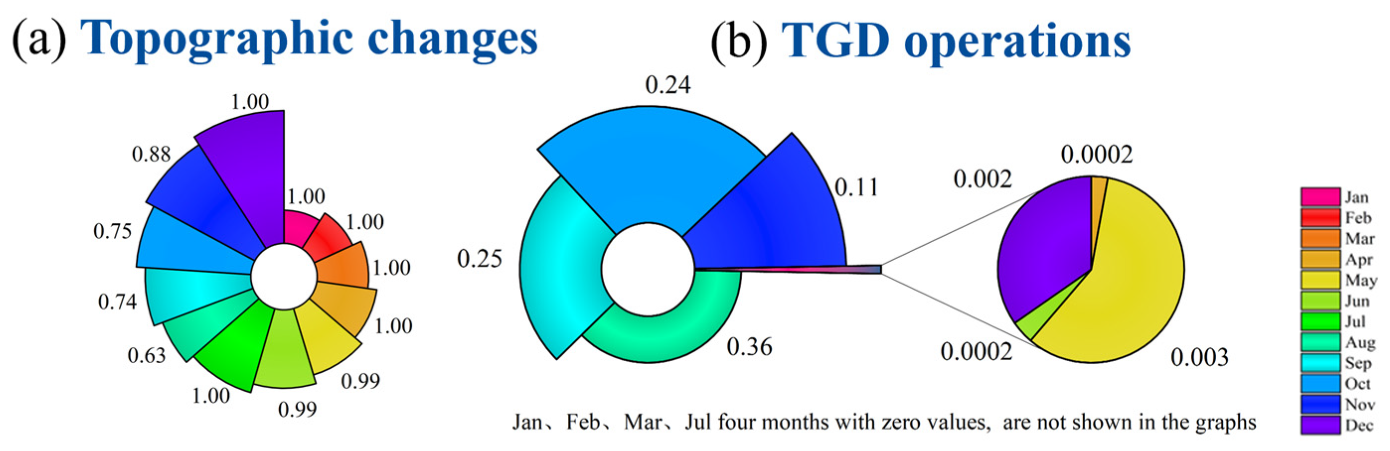
The monthly average contribution rate of topographic influence is generally higher than that of operational influence. Its annual contribution rate ranges from 0.63 to 1.00. Within this, the mean rate during the flood season (June–September) is 0.84, and during the dry season (January–March) it reaches 1.00. Overall, it shows an annual trend of first decreasing and then increasing: high during the dry season, decreasing during the water storage period of the TGD, and lowest during the flood season. This indicates that the reduction in flow resistance caused by channel downcutting in the confluence area has a dominant effect on amplifying the outflow throughout the year. Particularly from January to July, the contribution rate mostly remains above 0.99, reflecting that significant bed erosion at the Han River estuary during extreme flood periods substantially reduces the backwater potential of the main stem (Yangtze River), causing topographic factors to completely dominate the outflow.
The intermittent characteristic of the TGD operation’s contribution rate to the hydrodynamics at the Han River estuary is more pronounced. Its contribution rate ranges from 0.00 to 0.36 and is concentrated during the flood season and water storage period (August to November). The peak contribution rate of 0.36 in August coincides with the flood control operation period of the TGD. During this time, reduced discharge from the dam lowers water levels in the confluence area, increasing the water level difference between the main stem and tributary, which indirectly enhances the tributary’s discharge capacity. During the reservoir impoundment period (September to October), the contribution rates are 0.25 in September and 0.24 in October. Impoundment reduces outflow volume, leading to lower water levels in the confluence zone, an increased water-level gradient in the estuary reach, and stronger hydrodynamic forces. Consequently, the TGD operation maintains a relatively high contribution rate to the Han River outflow even during the storage period. In contrast, its contribution rate during the non-flood season (December to June) is generally low, exerting almost no influence. This indicates that during the non-flood season, the dominant effect of topographic changes on outflow overshadows the influence of operations, resulting in a minimal contribution rate of the TGD operations to the hydrodynamics at the Han River estuary. In essence, while the TGD operation significantly impacts Han River estuary hydrodynamics during specific periods, its contribution rate exhibits noticeable temporal fluctuations due to natural factors.
3.3. Spatiotemporal Heterogeneity Dynamics and Analysis
Comparative analysis of longitudinal water-level differentials (ΔH) and velocity differentials (ΔV) under four scenarios reveals significant spatial heterogeneity in the effects of topographic changes and TGD regulation. In the regulation-only scenario (S2 − S1), ΔH increases downstream from 65 km (Yuekou) to 265 km (estuary), peaking at −0.10 m near the confluence, indicating distance-dependent attenuation of mainstream backwater weakening. In the upper reach (0–65 km), water-level decline releases kinetic energy, increasing velocity by +0.11 cm/s on average, while in the lower reach (192–265 km), flow homogenization from regulation boosts velocity up to +2.49 cm/s. Under the topography-dominated scenario (S3 − S1), riverbed downcutting causes nonlinear amplification of ΔH, with a gradient of −6.42 × 10⁻⁴ m/km from Xinglong to Hanchuan; ΔV intensifies downstream, where enhanced channel slope post-erosion drives a peak velocity increase of +0.86 m/s, confirming spatially selective amplification of conveyance capacity. For regulation–topography interactions, regulation modulating topography (S3 − S2) deepens water-level decline at Hanchuan Station (192 km) to −0.172 m (18% > topography-only) and forms a velocity acceleration zone (120–180 km) with mean ΔV +0.0021 m/s, revealing amplified topographic effects.
Topography feeding back to regulation (S4 − S3) triggers a surge in the water-level gradient below 180 km to −1.41 × 10
−3 m/km (2.3× > 0–180 km segment), restructuring velocity response: the upper segment (0–120 km) shows ΔV converging to +0.0008 m/s, while the lower segment (192–265 km) sustains peak ΔV +0.0027 m/s, highlighting downstream redistribution of regulation energy by downcutting. Notably, under S4 − S3 with updated topography, the zone of largest water-level variation shifts downstream to 180–265 km, where the gradient intensifies to −1.41 × 10
−3 m/km; the upper segment (0–180 km) maintains a stable gradient of −6.16 × 10
−4 m/km and positive velocity response (mean +0.0017 m/s), with a pronounced acceleration belt at 120–180 km (peak in
Figure 5d). This confirms that riverbed downcutting redirects the regulating energy seaward rather than concentrating it upstream. Overall, the water-level response is more sensitive to topography (contribution > 85%), while velocity changes are governed by spatial heterogeneity in topography–regulation coupling; longitudinal gradient differences identify 180–265 km as a key target zone for flood control and ecological regulation.
Spatiotemporal heterogeneity analysis based on multi-factor interactions reveals that discharge evolution in the Han River Estuary segment is significantly co-regulated by topographic evolution and TGD operations (
Figure 6). Under the single-factor influence of TGD operations (S2 − S1), spatially inverse gradient responses emerge: in the upper reach (0–143 km), discharge increases by 0.4–1.8 m
3/s during the flood season (July–September), peaking at 1.8 m
3/s at 143 km, while in the dry season (January–March), mid-lower reaches (143–240 km) experience reductions of 0.00008–0.0001 m
3/s, with a distinct reduction zone of −0.0001 m
3/s at the tributary–mainstem confluence (192–240 km), confirming operations’ role in redistributing intra-annual runoff.
Topographic evolution alone (S3 − S1) systematically enhances discharge capacity throughout the reach, with an annual mean reduction of 0.1 m3/s at 168–215 km; during April–June, peak zones extend to 240 km (+21.3 m3/s), indicating riverbed downcutting significantly accelerates flood wave propagation. Coupled topography–operation effects (S4 − S2/S3) exhibit nonlinear superposition: downstream (168–240 km) shows operational amplification of topographic gains during floods (peaks surge from +7.24 to +21.8 m3/s) and synergistic amplification in dry seasons (mean rises from 0 to +0.4 m3/s). Notably, at the confluence terminus (215–240 km), polarity reversal occurs in October–December discharge extremes (−2.4 to −7.8 m3/s), reflecting spatiotemporal coupling of topographic changes and operational pulses altering flow inertia. This multi-scale response mechanism unveils how altered hydrodynamic boundary conditions reshape estuarine discharge pathways.
4. Discussion
This study elucidates the dynamic response of discharge capacity in the Han River Estuary to coupled natural and anthropogenic drivers—riverbed incision and TGD operation. Our findings reveal that channel downcutting is the dominant driver of enhanced discharge capacity, contributing to over 84% annually on average. This incision reduces the Yangtze’s backwater potential, significantly increasing tributary conveyance efficiency, particularly during the flood season (July–September), where peak flow increases by 21.3 m
3/s were observed. This phenomenon of incision-driven flow enhancement aligns with global observations in regulated rivers experiencing significant bed erosion. For instance, in the Mississippi River, extensive channel deepening has fundamentally altered sediment distribution and saltwater wedge dynamics, necessitating multi-scale hydrodynamic models to manage navigation and ecosystem trade-offs, albeit with different tidal influences compared to the Han’s non-tidal estuary [
3,
16]. Similarly, the Rhône River in France experienced significant post-dam incision, leading to increased low-flow conveyance and altered floodplain connectivity, highlighting a common response pattern where reduced flow resistance amplifies discharge capacity [
28].
The contribution of TGD operation exhibits distinct spatiotemporal intermittency. Its influence is concentrated during specific periods (e.g., contributing 25–36% during impoundment, September–October), primarily by lowering mainstem water levels and reducing backwater effects, thereby increasing the confluence slope. However, its impact diminishes to near zero during the non-flood season, overshadowed by the persistent effect of incision. This “time–window effect” of reservoir regulation on estuarine hydrodynamics finds parallels in other major systems. The operation of large reservoirs like the Aswan High Dam on the Nile significantly alters downstream flow regimes and salinity intrusion patterns, though the Nile Delta’s tidal dynamics differ [
29]. More pertinently, the Mekong Delta experiences complex flow modifications from upstream dams (like Jinghong and Xiaowan), impacting flood pulse timing, sediment delivery, and saltwater intrusion across its distributaries, demonstrating how reservoir schedules can reconfigure estuarine hydrodynamics on a seasonal basis [
5,
30]. The intermittency observed in the Han underscores the critical importance of timing in reservoir impacts relative to natural flow phases and morphological states.
Crucially, the interaction between these drivers reshapes flow paths through nonlinear synergies and antagonisms. At low confluence ratios (R < 0.15), TGD-induced backwater (increasing Cd at Hanchuan to 45) antagonizes incision-driven backwater weakening (decreasing Cd to 8). Conversely, synergy dominates at high ratios (R > 0.25), further suppressing Cd (to ~1.0) and reducing Hanchuan flow by 13.84 m
3/s. This polarity reversal, governed by the mainstem–tributary water-level relationship, reveals a complex coupling mechanism. Similar nonlinear interactions occur globally. In the Rhine–Meuse Delta, coordinated reservoir operations during extreme events (e.g., 2011 flood) dynamically managed discharge to protect Rotterdam, demonstrating how engineered flow control interacts with existing channel capacity to mitigate flood risks [
7]. The Mississippi River diversions aim to rebuild wetlands but create complex feedbacks between river discharge, sediment supply, and deltaic morphology, showing how human interventions and natural processes co-evolve, sometimes synergistically, sometimes antagonistically, in shaping estuarine dynamics [
3,
16].
Spatially, the confluence-proximal zone (180–265 km) is identified as highly sensitive to “dual-driver” disturbances. Here, coupled scenarios intensify the water surface gradient to −1.41 × 10
−3 m/km (2.3 times steeper than upstream) and concentrate velocity increments (+0.0027 m/s). This energy concentration relates to the estuary’s funnel shape, narrow channel geometry (100–200 m width at Hanchuan), and Quaternary sedimentary layers with low erosion resistance. The “strong backwater without tides” characteristic makes it particularly vulnerable to pulsed mainstem disturbances. This finding resonates with studies on other non-tidal or micro-tidal estuaries impacted by upstream dams. For example, the Ebro Delta in Spain is highly sensitive to flow reductions from upstream regulation, exacerbating saltwater intrusion and altering sediment dynamics [
31]. The identification of specific sensitive zones, like the Han’s 180–265 km reach, is critical for targeted management, mirroring the focus on hydraulic bottlenecks or ecologically critical areas in estuaries like the Sacramento–San Joaquin [
16] or the Godavari in India [
32]. The Han case underscores that the hydrodynamic response magnitude and spatial patterns result from the interplay between pulsed anthropogenic disturbances (TGD operation) and the legacy of cumulative natural adjustments.
The proposed “Natural/Anthropogenic Dual-Stressor Framework” integrates these dynamics, providing a theoretical basis for managing the Han River Estuary and a transferable paradigm for similar systems globally. It highlights the need to consider both the persistent morphological evolution and the transient hydraulic pulses from upstream projects. Future research should integrate sediment transport feedbacks and explore collaborative optimization thresholds for trans-basin projects like the South–North Water Diversion, considering critical thresholds such as the 28.5 m water level at Hankou. The framework’s applicability extends beyond the Yangtze system, offering insights for managing estuarine discharge in the face of intensive human interventions worldwide, particularly in non-tidal settings facing similar challenges of upstream reservoir regulation and morphological change.
5. Conclusions
This study quantifies the dual control of riverbed incision and TGD operations on discharge capacity evolution in the Han River Estuary. Channel downcutting enhances flood season conveyance efficiency, while TGD operations exhibit spatiotemporal intermittency, contributing 25–36% during impoundment (September–October) through backwater reduction. Notably, our 1D hydrodynamic model (MIKE11) effectively captured large-scale spatiotemporal patterns but has inherent limitations in resolving 3D turbulence effects at the confluence zone and sediment transport feedbacks—a critical constraint given the estuary’s Quaternary sedimentary layers with low erosion resistance. Nonlinear driver interactions reconfigure flow paths, causing antagonism at low confluence ratios and synergy at high ratios.
Spatially, the 180–265 km reach is identified as a sensitive zone where coupled drivers amplify water surface gradients to −1.41 × 10⁻³ m/km (2.3× upstream) and velocity increments to +0.0027 m/s. While these findings are context-specific to the Han’s “non-tidal yet intense backwater” system, the “Natural/Anthropogenic Dual-Stressor Framework” offers broader applicability: it can inform management in similar tide-free estuaries impacted by upstream regulation but requires calibration for tidal systems like the Mississippi or Mekong, where salt–freshwater interactions fundamentally alter backwater dynamics.
The framework provides actionable strategies for the Han River and trans-basin projects globally. Key limitations to address in future work include extending to 2D/3D sediment–transport coupling to resolve long-term morphodynamic feedbacks and validating the framework under diverse climatic/hydrological regimes. Collaborative optimization of dam operations and morphological monitoring in the 180–265 km hotspot could advance sustainable governance of intensively managed estuaries worldwide.


