Article

Assessment of Spatial Equality and Social Justice of Urban Park Distribution from Park Category Perspective: Evidence from Shanghai, China

1
College of Architecture and Urban Planning, Tongji University, Shanghai 200092, China
2
Eco-SMART Lab Attached to Key Laboratory of Ecology and Energy-Saving Study of Dense Habitat, Tongji University, Ministry of Education, Shanghai 200092, China
3
Shanghai Key Laboratory of Urban Design and Urban Science, NYU Shanghai, Shanghai 200122, China
4
School of Ecological and Environmental Sciences, East China Normal University, Shanghai 200062, China
5
Shanghai Urban Planning and Design Research Institute, Shanghai 200040, China
6
The Shanghai Planning and Natural Resources Bureau, Shanghai 200003, China
*
Author to whom correspondence should be addressed.
These authors contributed equally to this work.
Sustainability 2025, 17(12), 5474; https://doi.org/10.3390/su17125474
Submission received: 27 April 2025 / Revised: 5 June 2025 / Accepted: 10 June 2025 / Published: 13 June 2025
(This article belongs to the Section Sustainable Urban and Rural Development)

Abstract

:
Urban parks deliver vital ecosystem services and enhance residents’ well-being globally, yet equitable access remains challenging in high-density cities. The prevailing planning paradigms predominantly rely on proximity-based metrics, overlooking critical interactions between demographic diversity, differentiated social demands, and park typology distinctions. Moreover, the existing studies frequently examine aggregate green space distributions without categorically analyzing justice implications. This study develops a geospatial–quantitative framework integrating spatial equality and social justice metrics, applied in Xuhui District, Shanghai. Key findings reveal the following: (1) spatial inequality characterized by large parks clustered in low-density peripheries, while high-density central zones lack adequate park coverage; (2) significant social justice deficits for priority groups (elderly, youth, low-income), exacerbated by insufficient consideration of socioeconomic needs; (3) pronounced disparities in justice across park types, with pocket parks exhibiting the most severe inequities. Consequently, we recommend prioritizing the social demand in park allocation and implementing community-centered pocket park development. This study not only diagnoses spatial–environmental injustices in high-density urban cores but also provides a transferable framework for equitable park planning.

1. Introduction

Urban parks are vital components of urban public services, providing extensive ecological and social benefits to cities and their residents. They mitigate noise and air pollution [1,2] while also addressing residents’ non-material needs through support for social and mental health [3]. These functions directly align with the World Health Organization (WHO)’s “healthy cities” vision and United Nations Sustainable Development Goal (SDG) 11.7, which calls for universal access to green spaces by 2030 [4]. While the WHO recommends a minimum of 9–12 m2 per capita for basic health resilience [5], official data show that Shanghai’s per capita green park space was 8.8 m2 in 2021, with Xuhui District—one of the city’s most densely populated areas—reporting only 5.82 m2 per capita, far below the ideal threshold. This disparity highlights urgent challenges in achieving spatial equity and social justice in high-density urban cores. The distribution of urban parks, as a critical component of public infrastructure, is central to social justice frameworks [6,7,8]. However, the prevailing planning paradigms predominantly rely on proximity-based metrics, overlooking interactions between demographic diversity, differentiated social demands, and park typology distinctions [9].
Regarding the issue of equity and justice in the distribution of urban parks, the two main aspects of spatial equality and social justice are discussed [10,11]. Tang et al. argued that spatial equality and social equity are crucial for the social performance of public facilities, such as urban parks [10,11]. The study on the spatial disparity of urban parks across different areas aimed to identify regions that lack adequate park services [12]. However, scholars have emphasized that the equal spatial distribution of parks does not guarantee alignment with residents’ needs. Instead, analyzing the gap between the population demand and service provision to identify spatial disparities has become a key focus [6,13,14]. This perspective is increasingly being adopted in studies examining the match (or mismatch) between urban park provision and people’s actual needs. For instance, Lee and Hong (2013) found that in areas with high population densities, it is common for residents’ demands to remain unmet even if the number of parks in the area is high [13]. Therefore, city planners should not only consider the number of existing parks when planning new ones but also whether the park supply is able to meet residents’ demands.
Urban parks are distributed into different categories using a hierarchical classification system, yet their equity impacts remain understudied—especially in Shanghai, where conflicting evidence exists about access for priority groups. Xiao et al.’s studies suggest that priority groups, such as low-income individuals and immigrants, have improved park access in Shanghai [15,16], attributed to policy efforts like the “15-Minute Community Life Circle” initiative. However, these city-level findings mask intra-urban disparities: some high-density districts of Shanghai, such as Xuhui District, face acute park shortages, as highlighted by Shen et al.’s [17] study showing limited green space access for the elderly and unemployed. Given this mismatch between the city-wide progress and localized inequities, and the lack of research on park typologies (e.g., district vs. pocket parks) in serving priority groups, Xuhui District emerges as a critical case to unpack spatial and social justice complexities.
Urban park provision should pay particular attention to priority groups, including those with limited mobility or inadequate access to private recreation [18,19]. Unfortunately, their needs are often overlooked [20,21,22]. For instance, Yue Che et al.’s study in Shanghai found that priority groups, such as the elderly, children, and low-income individuals, face increased health risks related to heat, which may exacerbate the imbalance between the supply and demand of public resources such as blue and green spaces in urban areas, thereby contributing to social inequality [23,24]. Both young and older individuals are sensitive to walking distances [25,26]. The provision of urban parks can significantly enhance their well-being by providing them with opportunities to connect with nature and engage in social activities [25,27]. Furthermore, low-income groups often have inferior living environments due to the lack of green spaces. Residential communities with well-serviced green spaces or proximity to parks typically have higher housing prices, making them unaffordable for low-income individuals [8,28]. Therefore, it is widely recognized that different groups have varying abilities and needs, and increased attention should be paid to disadvantaged populations when providing basic public services, which is commonly referred to as social justice [10,11,21]. This aligns with the environmental justice framework, which highlights how spatial inequities disproportionately affect marginalized populations [8,29].
Various measures, such as accessibility, park acreage, and park quality, are frequently employed in different studies to assess whether the demands of disadvantaged groups are being met in this field. However, the results of numerous studies conducted in various cities and countries vary considerably. For example, Boone et al. [6] discovered that African Americans in Baltimore lacked sufficient park services, while Kabisch and Haase’s [21] research in Berlin found that immigrants had limited park access. Similarly, Rigolon (2017) found that ethnic minorities and low-income individuals in Denver had better park access but encountered disparities in terms of park acreage and quality [30]. Talen’s (2022) study of the ten largest cities in America demonstrated that Hispanics had the greatest park access, whereas Asian Americans had the least [31]. Furthermore, it has been observed that even when older and younger individuals have good accessibility to urban parks, this does not necessarily indicate an advantage in other aspects. In addition, disparities between different areas within the same city are common [30,32,33,34]. These variations underscore the need for context-specific analyses, particularly in aging, high-density cities like Shanghai.
Research gaps persist in integrating social justice with spatial equality and accounting for park typologies. While spatial analyses have increasingly considered population needs, few studies have developed comprehensive tools that combine both aspects. Additionally, the existing research often overlooks distinctions between different park categories when examining the overall distribution of parks or green spaces. For example, Zhou (2021) [35] created an assessment tool for mini-parks that incorporates the spatial distribution of residential lots and the residents’ demand as park demand factors. Huang et al. (2024) [14] introduced an enhanced two-step floating catchment area (2SFCA) method, incorporating real-time user data and the Huff model, to more accurately assess park accessibility and spatial equality in Nanjing. However, it is still unclear whether these initiatives effectively meet the real demands of the population and the specific demands of priority groups.
This study aims to analyze the distribution of urban parks in Xuhui District, Shanghai, from the perspective of park categories with a focus on priority groups, while considering both spatial equality and social justice. This study focuses on three priority groups: elderly people (60 years old or above), young people (under 18 years old), and low-income communities. Additionally, this study compares and analyzes the differences between district parks, community parks, and pocket parks in Xuhui District. In this way, this study proposes a geospatial–quantitative framework to systematically measure both spatial equality and social justice in park allocation, with explicit consideration of the park typologies in Shanghai’s Xuhui District, aimed at helping urban decision-makers effectively reallocate and supplement public parks. By proposing a geospatial–quantitative framework, this research seeks to inform equitable park planning in high-density urban cores, contributing to global debates on SDG 11.7 and “humanizing cities” through inclusive green space design. This study introduces two key indicators: urban park accessibility (UPA) for spatial equality and the service location quotient per capita (SLQP) for social justice.
This article is structured as follows: Section 2 introduces the study area, data sources, and research method. Section 3 shows the analysis and results of the spatial equality and social justice and the differences between the sub-districts, the three priority groups, and the three categories of parks. Section 4 discusses the results, which are potentially applicable to parkland planning practices in addressing urban park distribution to promote social equity and justice. Finally, Section 5 presents the research conclusions.

2. Materials and Methods

2.1. Study Area and Data Sources

2.1.1. Study Area

Shanghai, China’s second-largest and the world’s fifth-most-populous city, has made significant efforts to establish 15 min living service catchments. It is therefore considered that there is an increasing willingness to foster social justice [36]. Shanghai has proposed the construction of a “park city,” and through policies such as the Implementation Plan for Park City Construction in Shanghai During the 14th Five-Year Plan Period, it aims to increase the area and improve the quality of urban parks. The goal is to achieve a per capita green park space area of over 9.5 m2 by 2025, while emphasizing the open sharing of green spaces and the transformation of ecological value. This study focused on Xuhui District, located in the southwest of Shanghai, which is one of the most affluent districts with the highest density (Figure 1). With an area of 54 square kilometers, this district is historically acclaimed for its carefully designed built environment and rich cultural heritage. The district was selected for the following reasons: (1) The urban–rural gradient in Shanghai exhibits substantial spatial heterogeneity, distinctly partitioned by Inner Loop Road, Middle Loop Road, and Outer Loop Road. Xuhui District serves as a representative study area because it is crossed by all three loop roads. (2) It is purportedly lacking in urban parks compared to other districts, making it more meaningful to study the distribution of urban parks and resulting outcomes. (3) In Shanghai’s urban green space planning, Xuhui District is positioned as a “Park City Demonstration Zone,” has been included in key areas for Shanghai’s park city construction, and its green space expansion work has been listed as a municipal-level key task (Implementation Plan for Park City Construction in Shanghai During the 14th Five-Year Plan Period). (4) More detailed planning schemes, including district planning and parkland technical planning, were available in Xuhui District.
This study adopted the “sub-district” (“Jiedao” in Chinese) as the basic spatial unit for each indicator. Xuhui District comprises 13 sub-districts. Based on the development stage, residential building density, and social characteristics, three of these sub-districts were further classified into two parts by main roads, resulting in a total of 16 spatial units.

2.1.2. Urban Park Categories

This article adopted a hierarchical classification of urban parks based on the Urban Greenland Classification Standard (CJJ/T85-2017) [37], Urban Greenland Planning Standard (GB/T 51346-2019) [38], and Shanghai Urban Master Planning Scheme (2017–2035). The classification includes four categories of parks: comprehensive parks, district parks, community parks, and pocket parks, which are determined by their functions and sizes. Comprehensive parks, typically over 50 hectares, are important recreational destinations offering various leisure opportunities for urban residents. However, there is only one comprehensive park, namely, Shanghai Botanical Garden, which was excluded from this study due to its lack of free public access. District parks, which usually exceed 4 hectares or consist of green belts wider than 30 m, provide outdoor activities for residents within the district and support ecological functions and local culture. Community parks, exceeding 0.3 hectares or 8 m wide green belts, offer recreational amenities that enhance residents’ health and communication. These parks also emphasize openness, accessibility, and participation. Pocket parks, smaller than 0.3 hectares, serve as finer-scale public open spaces scattered throughout a city and cater to residents in the surrounding neighborhoods. The different categories of parkland in Xuhui District are detailed in Table 1. The current research predominantly focuses on the analysis of green spaces or urban parks, with a noticeable scarcity of studies categorizing them, which represents a significant innovation of the present paper.

2.1.3. Data Sources

Data for this study were derived from the following sources:
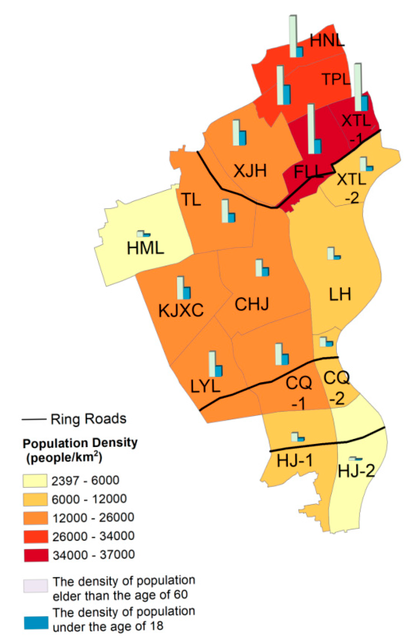
  • The Seventh National Census of China’s 2020 geographic dataset for census tract boundaries, demographic statistics, and sub-district boundaries. The demographic statistics include the total resident population, the elder population (over 60 years old), and children/youth (under 18 years old) (Figure 2).
  • Relative planning schemes provided by the local government of Xuhui District, including the 14th Five-Year Plan for Landscaping and City Appearance of Xuhui District, the Regulatory Unit Planning of Xuhui District (2022), the Urban Greenland Classification Standard (CJJ/T85-2017), the Urban Greenland Planning Standard (GB/T 51346-2019), and the Shanghai Urban Master Planning Scheme (2017–2035).
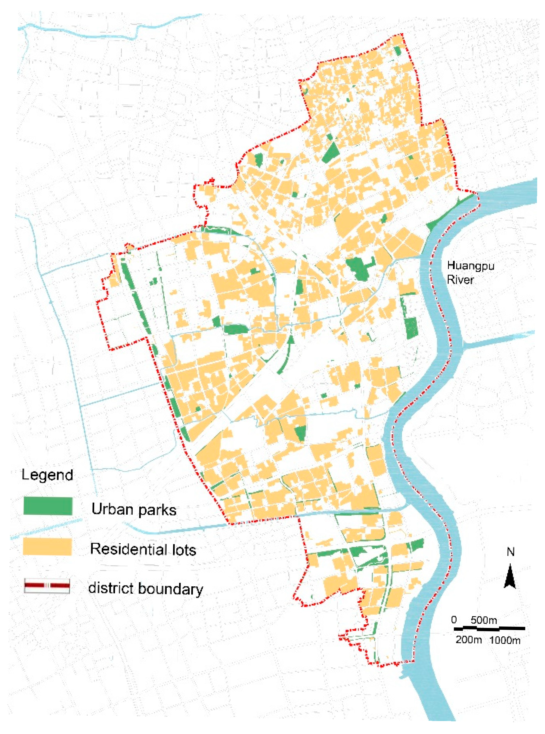
  • Remote sensing data of parkland, which were enclosed in the Remote Sensing Investigation Report of Green Spaces in Xuhui District (Figure 3).
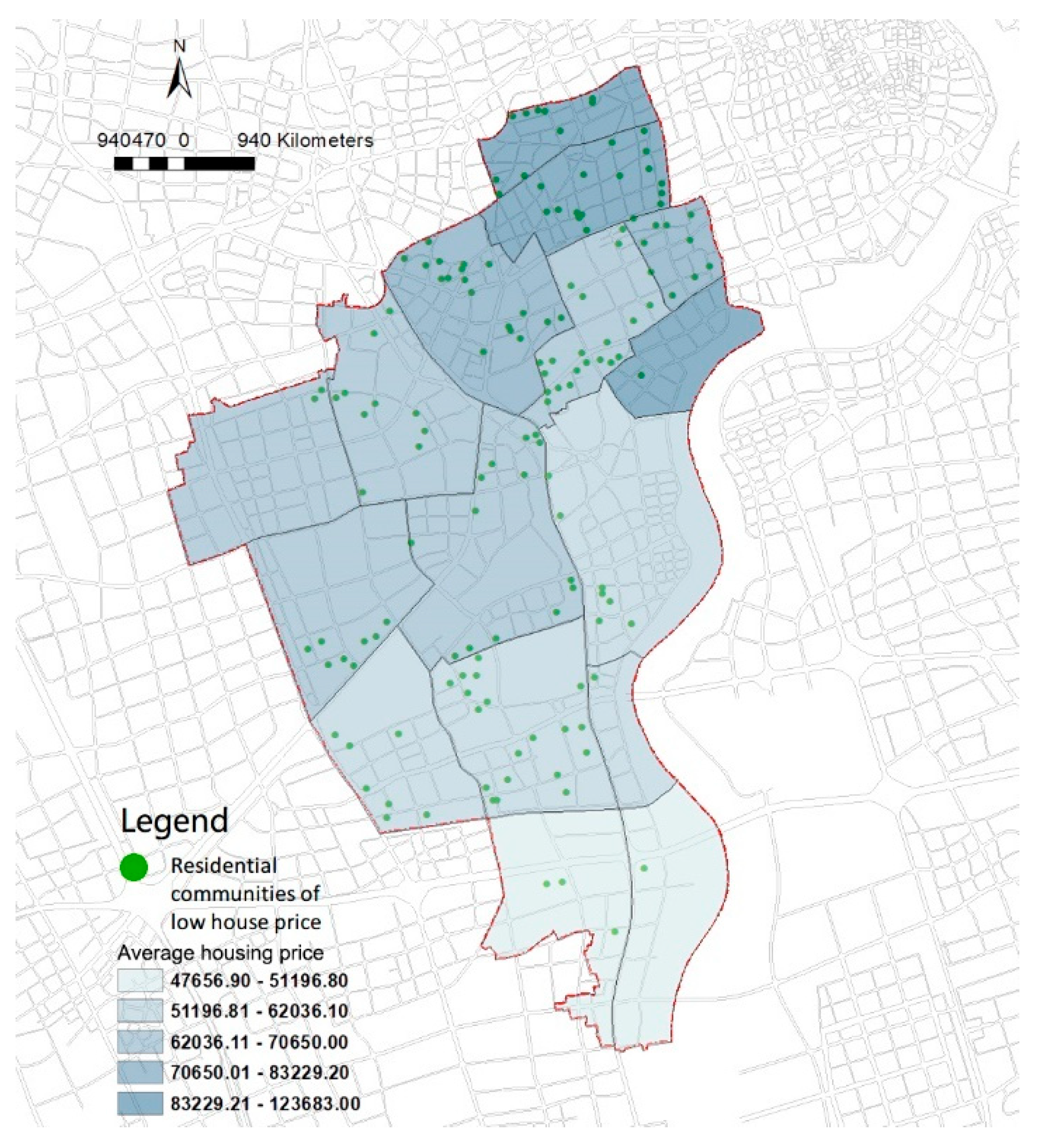
  • On-site investigations of existing urban parks and the housing prices of each neighborhood. The housing prices of 651 residential communities were recorded.

2.2. Methods

The framework of our research design is shown in Figure 4, including the data collection, measurement of spatial equality, measurement of social justice, and analysis of spatial equality and social justice.

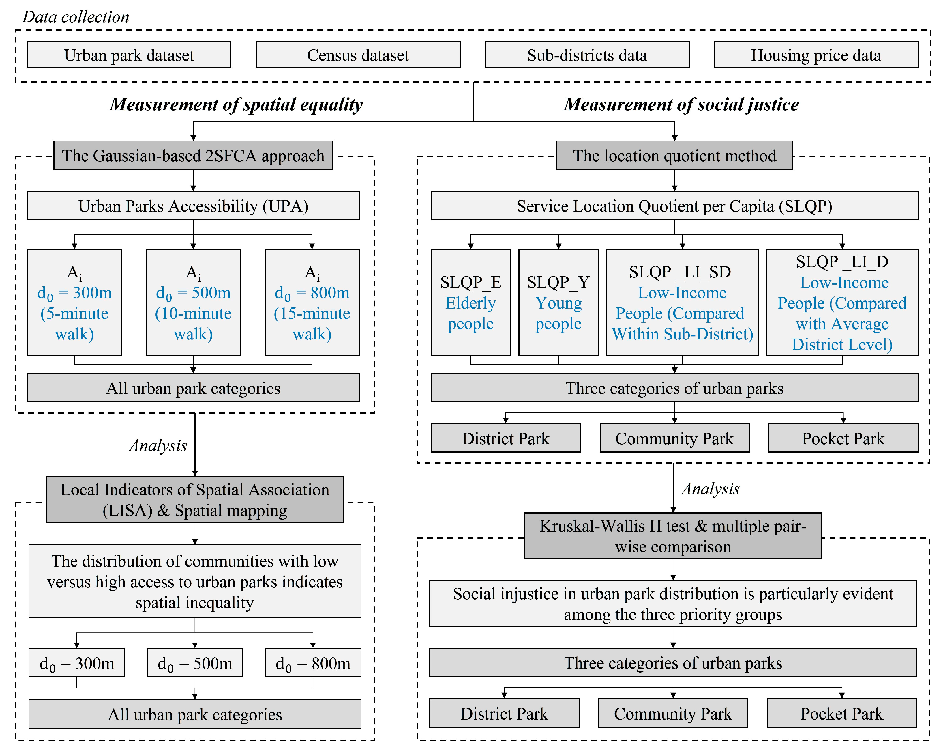
2.2.1. Measurement of Spatial Equality

  • Urban Park Accessibility (UPA)
Accessibility refers to the ease of overcoming various resistances to reach a destination from a source site [25,36,39,40,41]. Its evaluation methods usually consider the distance, time, and cost, such as buffer zone analysis, network analysis [39], minimum proximity methods, cost-weighted distance methods, and gravitational potential analysis [26,40]. Among them, Gaussian-based 2SFCA (two-step floating catchment area) accessibility, which employs the principles of gravity-based models, is deemed to be one of the most suitable and effective models, as it incorporates supply, demand, and distance aspects into the accessibility index [42,43,44].
We imported urban park data, community and road network distribution data, residential community block division data, and population data (aggregated to community units) into the ArcGIS platform. Using ArcGIS tools, we converted the areal urban parks and residential community blocks into point features, represented by centroid points. During the subsequent 2SFCA method analysis, we applied the neighborhood analysis tool for searching.
The Gaussian-based 2SFCA approach consists of two steps: (1) Identify all the demand locations (i) within a threshold distance (d₀) from parks (j). Demand locations are defined as centroids of community tracts, with population data weighted by a Gaussian function (G). This study selected threshold distances (d0) of 300 m, 500 m, and 800 m, corresponding to walking durations of 5 min, 10 min, and 15 min, respectively. These thresholds are quoted from the national standard Urban Residential Area Planning and Design Standard (GB50180-2018) [45] issued by the Ministry of Housing and Urban-Rural Development of China (https://www.mohurd.gov.cn/gongkai/zc/wjk/art/2018/art_17339_238590.html (accessed on 4 June 2025)). The park-to-population ratio (Rj) was calculated as follows:
R j = S j A i d i j d 0 G d i j , d 0 P i
where Pi is the residence population in the demand location (i); Sj is the size of park (j) in square meters; dij is the shortest network distance between the centroid of community (i) and park (j); G is the Gaussian function, formulated as follows:
G d i j , d 0 = e x p 0.5 d i j / d 0 2 e x p 0.5 1 e x p 0.5 0   ,   if   d i j > d 0 , i f   d i j d 0
(2) Calculate the accessibility for the demand locations (i) by summing the weighted park-to-population ratios (Rⱼ) of all parks (j) within d₀ of (i), using the same Gaussian function (G) for weighting:
A i = j d i j d 0 G d i j , d 0 R j
where Ai is the park accessibility index of community (i), which represents the availability of the park area (in m2/person) for each demand location or community (i).

2.2.2. Measurement of Social Justice

The location quotient is a common method used to measure distribution equity [46,47,48]. It helps to identify disparities between a specific unit and the average. In this study, the residential population represents the service demand, and the alignment between urban park service resources and the residential population is assessed. The service location quotient per capita (SLQP) indicates the actual park service accessible to residents within a spatial unit. When the SLQP of a spatial unit is greater than 1, it means that the capital of urban parks per capita exceeds the study area average, and vice versa. The population data used here were all aggregated to “Jiedao” spatial units for analysis. Excel and SPSS Statistics 27 were used as the calculation tools.
This study examines three priority groups in relation to social justice: the elderly (individuals aged 60 or above), young people (individuals under the age of 18), and low-income communities (identified using housing prices as a proxy for income levels). We assume that communities with lower housing prices generally have lower incomes.
This study uses the SLQP of elder people (SLQP_E) and SLQP of young people (SLQP_Y) to describe the levels of urban park service resources among these two priority groups:
S L Q P _ E   o r   S L Q P _ Y = T d s / P d w T q s / P q w
where T d s is the total area of all urban parks that residential lots in a spatial unit can reach; T q s is the total area of all urban parks that residential lots in the whole district can reach; P d w is the population of disadvantaged groups in this study in a spatial unit; P q w is the total population of the groups we studied in the whole district.
The SLQP focuses on low-income groups as well, and there are two indicators: the SLQP_LI_SD, which contrasts the per capita park service of low-income communities with the average level of the sub-district to reveal any inequities within each sub-district, and the SLQP_LI_D, which compares the per capita park service of low-income communities with the average level of the district to exhibit the differences among low-income communities across sub-districts:
S L Q P _ L I _ S D = T L I / P L I T s t / P s t
where TLI is the total area of all urban parks that the low-house-price communities can reach; Tst is the total area of all urban parks that residential lots in the whole sub-district can reach; PLI is the residential population of the low-house-price communities; and Pst is the total population of the sub-district;
S L Q P _ L I _ D = T L I / P L I T q s / P q
where Pq is the total population of the study area.

2.2.3. Analyses

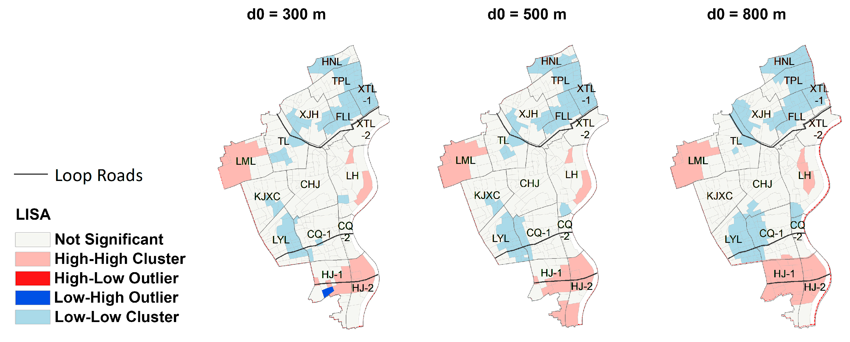
  • Local indicators of spatial association (LISA) for spatial inequality
This study follows Talen’s (1997) [48] and Li et al.’s (2015) [49] approach, using local indicators of spatial association (LISA) [50] to determine the existence of statistically significant spatial clusters of single or bivariate variables. Furthermore, it also gives us an indication of the spatial non-stationarity, outliers, and spatial regimes, similar to the use of the Moran scatterplot in Anselin (1996) [51]. Its formula is defined as follows:
I i = z i i z i 2 j w i j z i
where zi and zj are expressed in deviations from the mean, and wij is the spatial weight. The summation over j is across each row i of the spatial weight matrix. Indeed, the key strength of LISA is to allow for the detection of significant patterns of association around an individual location, including hot spots and spatial outliers [50].
  • Non-parametric analyses of Kruskal–Wallis H test for social injustice
Microsoft Excel 2013 and IBM SPSS Statistics 27 were used for processing and presenting data. Descriptive analysis was performed on the SLQP_E, SLQP_Y, SLQP_LI_SD, and SLQP_LI_D of district parks, community parks, and pocket parks (i.e., the maximum value, the minimum value, the mean value, and the standard deviation). Non-parametric analyses of the Kruskal–Wallis H test were used to determine the significance of the differences between categorical variables (such as district parks, community parks, and pocket parks). Then, a multiple pair-wise comparison between groups was conducted to identify the pairs of groups that were different.

3. Results

3.1. Measuring Spatial Equality Based on All Urban Park Categories

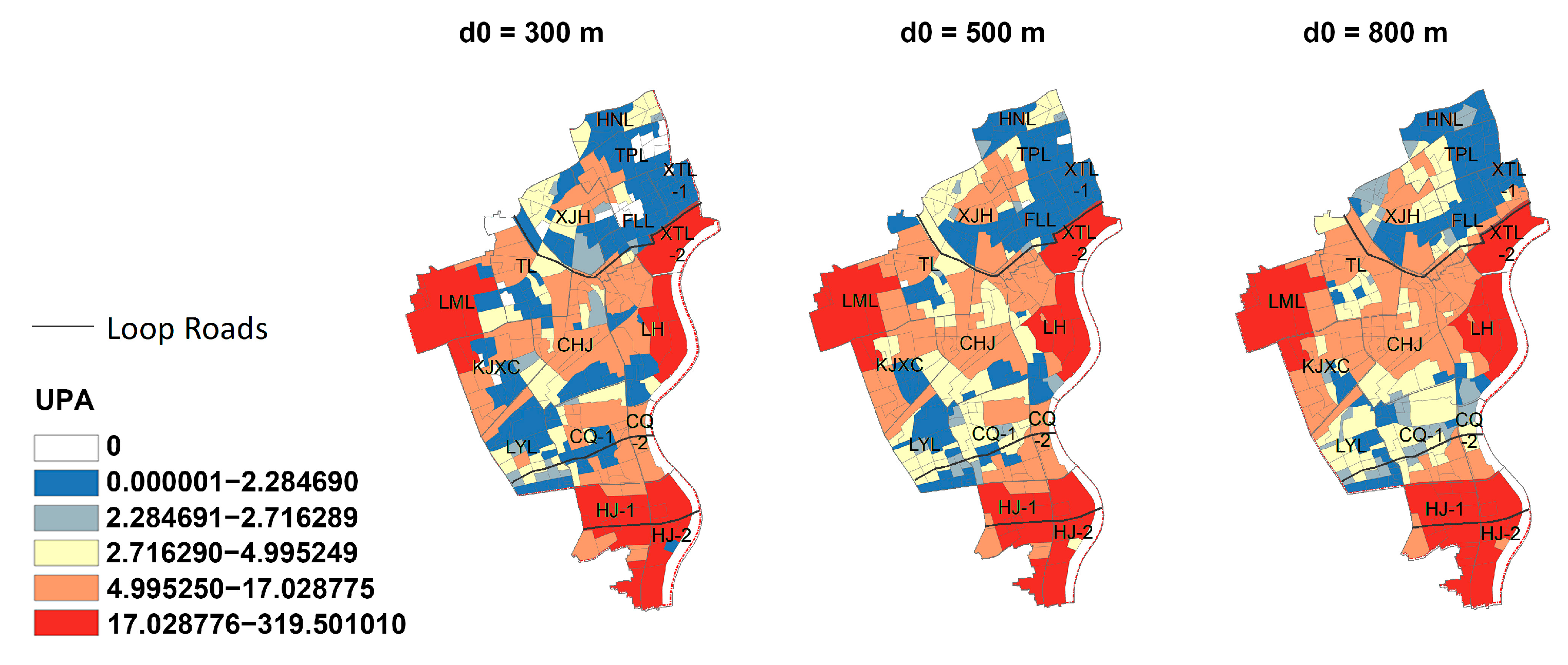
3.1.1. Spatial Characteristics of Urban Park Accessibility (UPA)

Figure 5 illustrates the spatial distribution of the high and low urban park accessibility for each residential lot in Xuhui District under different threshold distances. The spatial distributions of the high and low urban park accessibility under different threshold distances have the same trend, and the overall urban park accessibility increases with the enlargement of the threshold distance. Among them, 24 residential lots located in the northwestern part, the eastern part of the riverfront area, and the southern part outside the outer ring road in Xuhui District have high urban park accessibility and form three clusters; 38 residential lots located in the northern part within the inner ring road, the western part, and the southwestern part of Xuhui District have low accessibility (20 of them have 0 accessibility at d0 = 300 m, and there is no residential community with 0 accessibility until d0 = 800 m), forming a circle of low urban park accessibility inside the three high-accessibility clusters. Generally, units inside the inner ring road have lower urban park accessibility, which could be due to their location in the city center, where the land supply is tight in a high-density megacity like Shanghai, resulting in insufficient land for parks. In contrast, units around the outer ring road are less intensely developed and have relatively more land available for parks to fulfill the city’s park targets.

3.1.2. The Distribution of Communities with Low Versus High Access to Urban Parks Using LISA

Figure 6 shows that residential lots in the northwestern part, the eastern part of the riverfront area, and the southern part outside the outer ring road in Xuhui District (light-red clusters) have high accessibility to urban parks, and their neighboring residential lots also have high accessibility to urban parks. Residential lots with lower accessibility to urban parks and their neighboring residential lots with lower accessibility to urban parks are typically located in the northern part within the inner ring road and the southwestern part of Xuhui District (light-blue clusters). There is only one residential lot with a Low–High outlier (navy-blue outlier), which means that the residential lot has high urban park accessibility while its neighboring residential lots are the opposite. As the threshold distance increases, the range of these clusters expands, and the spatial distribution tends to be constant, while the outliers disappear.

3.2. Measuring Social Justice Based on Three Categories of Urban Parks

The service location quotient per capita (SLQP) calculates the parking area per capita that serves a unit, regardless of whether it is located within the unit, and compares it with the average. This section will analyze the state of social justice at the sub-district level, with a specific focus on priority groups (elder people, young people, and low-income people). Moreover, it will elucidate the discrepancies between the spatial distribution and the satisfaction of the communities’ needs.

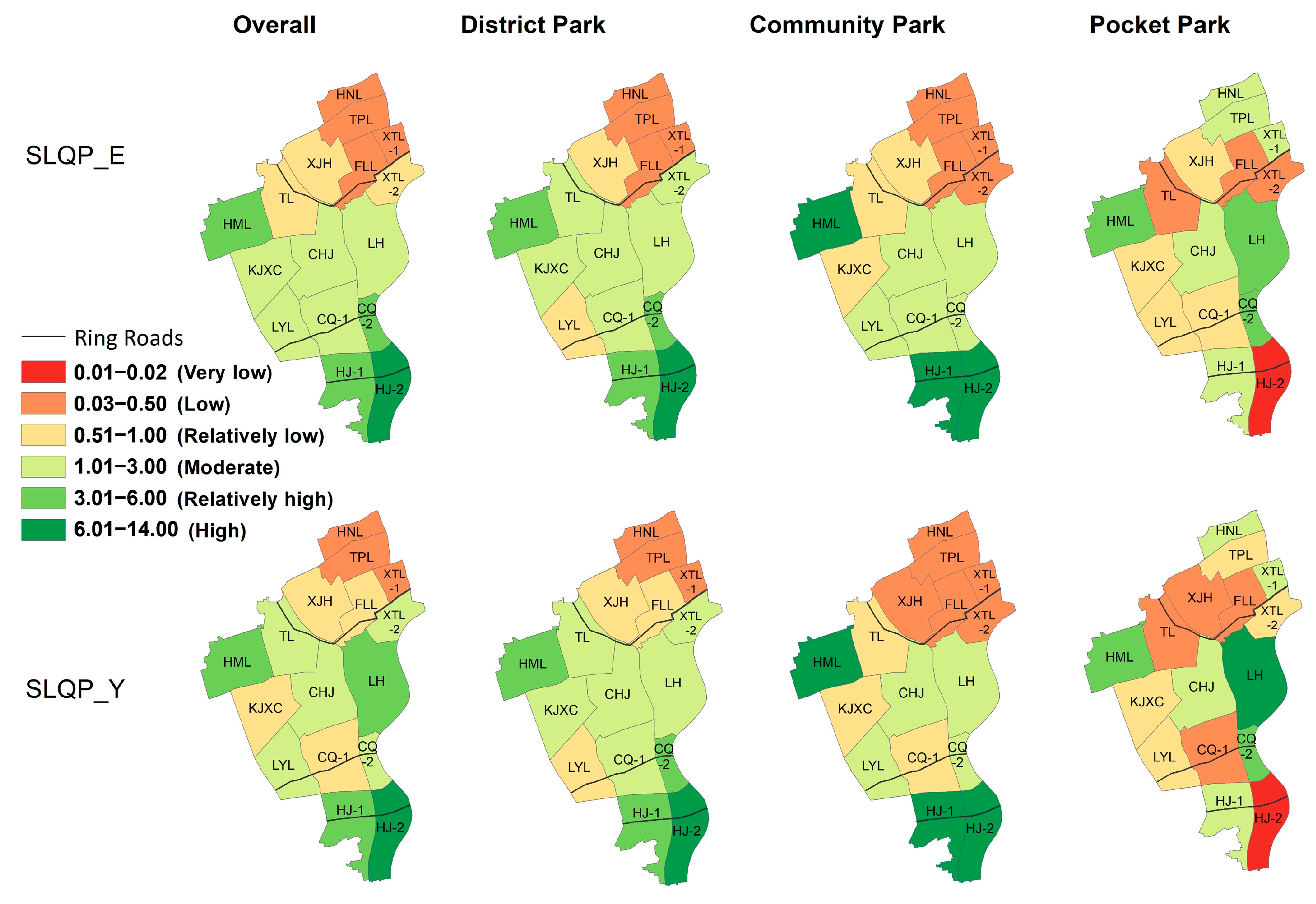
3.2.1. Social Justice Related to Elder People and Young People

Figure 7 presents the overall results of the service location quotient per capita of elder people (SLQP_E) and the service location quotient per capita of young people (SLQP_Y), which exhibit a general similarity. However, there are exceptions in several units. For instance, TL and XTL-2 show moderate SLQP_E values but relatively low SLQP_Y values, while KJXC and CQ-1 display the opposite trend.
The Kruskal–Wallis test (Figure 8) proved that there are not really significant differences in the SLQP_E (p-value 0.762 > 0.05) and SLQP_Y (p-value 0.758 > 0.05) in the three categories of urban parks. This demonstrates that there are no significant differences in the service levels among the three categories of urban parks for elder and young people, indicating a similar spatial distribution of service levels. By analyzing the location quotient values, it can be observed that, overall, the three types of parks located outside the inner ring road in Xuhui District provide services to both elder and young people that are generally above the district’s average level. Conversely, the areas within the inner ring road demonstrate a contrary trend, indicating that elder and young residents within this zone have experienced inequitable treatment. Additionally, it is evident that HJ-2 exhibits high SLQP_E and SLQP_Y values for district parks and community parks, whereas the indexes are considerably low for pocket parks. This finding implies that the elderly and young residents in HJ-2 have fewer pocket parks in close proximity to their homes. These observations are noteworthy given that pocket parks are significant recreational areas for the elderly and youth, particularly due to their limited mobility, as highlighted in the literature review.

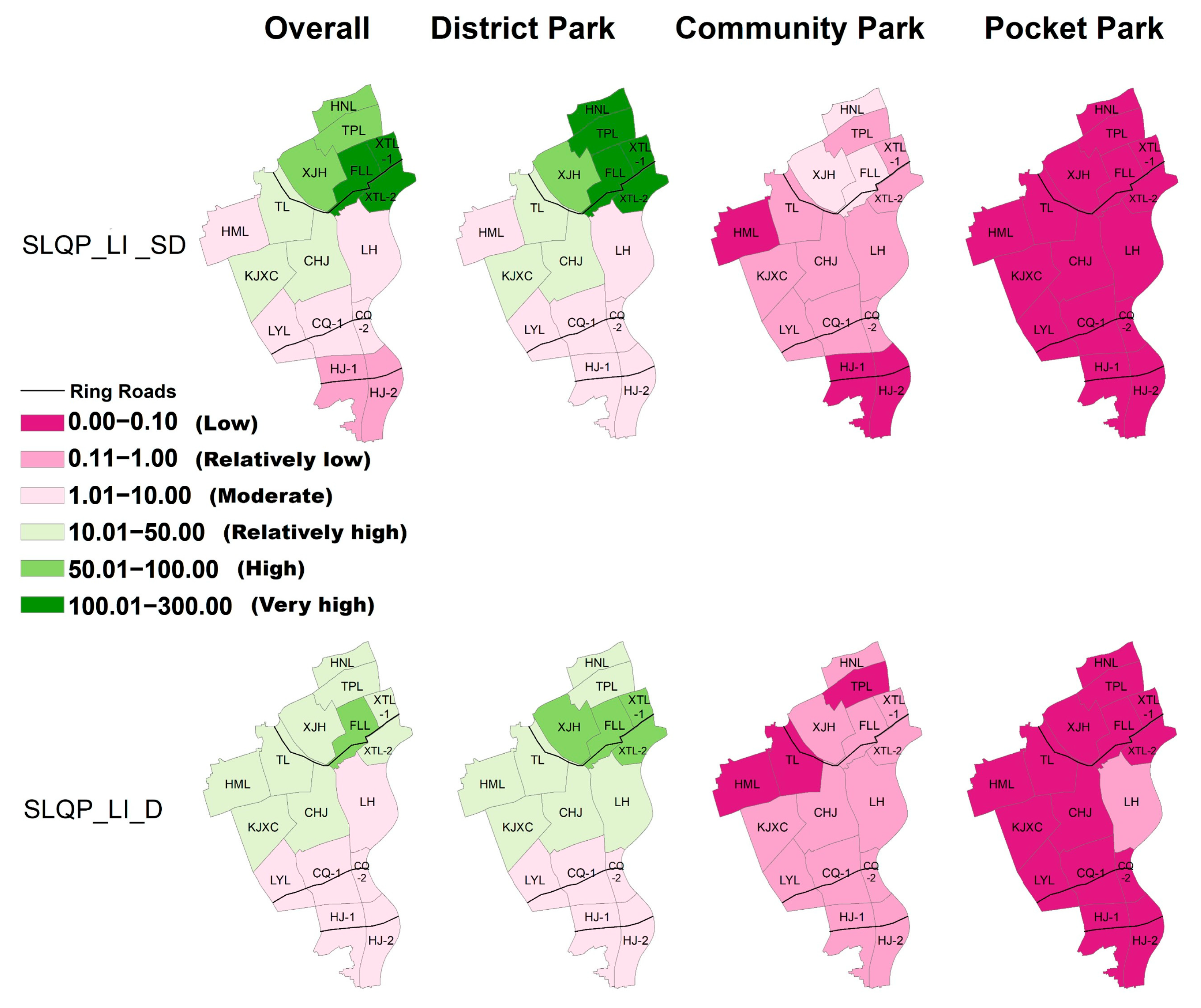
3.2.2. Social Justice Related to Low-Income People

Based on Figure 9, a discernible spatial disparity is observed in the average housing prices across the sub-districts, varying from the inner to outer ring road, indicating a pattern of stratification. In Xuhui District, the average housing price is 78,747.27 RMB/m2 (equivalent to USD 11,599.24), with the sub-districts of HNL (123,683 RMB/m2, equivalent to USD 18,218.15) and TPL (113,631 RMB/m2, equivalent to USD 16,735.05) boasting the highest prices but limited park provisions. Conversely, despite HJ-1 and HJ-2 having the lowest housing prices, the data indicate that their park provisions are relatively abundant.
Due to the substantial disparities in the housing prices and park provisions among the sub-districts, our research focused on examining the internal dynamics within each sub-district, specifically comparing communities with varying house prices within a single sub-district. Although it may initially appear that urban parks do not impact housing prices at the sub-district level, our study reveals contrasting findings when examining the community level, which is subordinate to the sub-district level. We specifically selected the communities in the lowest quintile of housing prices within each sub-district (a total of 147 communities, as depicted in Figure 9) and compared their service location quotients per capita (SLQP_LIs) with the overall sub-district and district levels.
This showed that the different categories of urban parks have significant differences in their SLQP_LI_SD and SLQP_LI_D values (Kruskal–Wallis test, p-value of SLQP_LI_SD = 4.09 × 10⁻⁹, p-value of SLQP_LI_D = 3.59 × 10⁻⁹, p-value < 0.05). Furthermore, there are significant differences between each pair of district parks, community parks, and pocket parks. This indicates that the distribution of the SLQP_LI_SD and SLQP_LI_D values for district parks is relatively dispersed, with a significant gap between the maximum and minimum values. This suggests substantial disparities in the access to district park resources for low-income people across different sub-districts of Xuhui District, reflecting inequitable conditions. In contrast, the SLQP_LI_SD and SLQP_LI_D values for community parks and pocket parks are concentrated within the 0-1 range, indicating smaller differences in the access to these resources for low-income people across various sub-districts, thus suggesting a relatively fair distribution.
A comparison with the average level of this district reveals a pronounced disparity among these communities, particularly regarding pocket parks (as illustrated in Figure 10). In contrast to the average district level, the average service location quotients per capita of low-income people (SLQP_LI_D) for community parks and pocket parks are, respectively, 0.19 and 0.03. Consequently, these low-income residents have limited access to public parks in close proximity to their homes. The indicators for district parks show significantly higher values, primarily due to their expansive coverage and the smaller population serving as the denominator in this calculation.
Analyzing each sub-district individually, Figure 10 reveals that the average service location quotients per capita of low-income people (SLQP_LI_SD) for community parks and pocket parks are notably low (0.58 and 0.03, respectively), indicating a significant disadvantage faced by low-housing-price communities. In terms of community parks, the FLL, HNL, and XJH sub-districts exhibit SLQP_LI_SD values exceeding 1. However, when considering pocket parks in all sub-districts, the SLQP_LI_SD values are below 0.1. Particularly noteworthy are the HML and HJ sub-districts, which indicate SLQP_LI_SD values of 0 and exemplify the sub-districts with the highest and lowest provisions of pocket parks. This observation implies that lower-priced neighborhoods consistently receive fewer park resources, irrespective of the overall park availability in their vicinities. Notably, even though the HNL sub-district and TPL sub-district, characterized by higher average housing prices, boast more pocket parks than the district average, the communities within these sub-districts belonging to the lowest quintile of housing prices still face substantial disadvantages regarding pocket parks, despite their housing prices surpassing the district average. This underscores an injustice among communities of varying socioeconomic levels, particularly concerning pocket parks, within these high-housing-price sub-districts.

4. Discussion

This study aimed to measure both spatial equality and social justice in urban park distribution, focusing on park categories, with Xuhui District, Shanghai, as a case study. Simultaneously, this study explored the social justice of access to urban park resources for priority groups in Xuhui District. Overall, the distribution of urban parks in Xuhui District exhibits spatial inequities and social injustices in certain areas. In terms of park classification, district parks, due to their extensive service range, provide residents with a variety of choices; in contrast, pocket parks are evidently insufficient, especially for low-income groups.

4.1. The Overall Distribution of Urban Parks Exhibits a Certain Degree of Inequity

As indicated in the Results Section, the units located in the northern part within the inner ring road experience intense development, high population densities, and less per capita park resources, while the units located in the southern part outside the outer ring road are less developed and have lower population densities and more per capita park resources. This demonstrates the inequity in the park allocation, observed not only in some densely populated cities like Hong Kong [52] but also in Xuhui District, Shanghai. Areas with high demand for parks often face limited land availability for park construction, leading to inequality among residents.
In summary, the results of the park allocation spatial disparity prove that the park spatial distribution in Xuhui District does not ensure equal and fair access to park services for its residents. However, these findings may be somewhat limited due to the small sample size of only 16 units, and the correlation analysis utilizing the local indicators of spatial association is merely an initial exploration. The administrative division of Xuhui District naturally constrains the dataset, as the research units for China’s population census data are “Jiedao”. However, this granularity aligns with Shanghai’s district-level planning practices. While the sample is small, our use of spatial statistical methods and demographic stratification strengthens the validity of the localized findings.

4.2. Priority Groups in Xuhui District Need More Attention

The results indicate that, from a social justice perspective, the urban park services in certain sub-districts of Xuhui District are below average for elderly individuals with limited mobility and young people requiring more activity space. The spatial pattern of the urban parks in Xuhui District—characterized by “high-density, low-green space in the inner ring and low-density, high-green space in the outer ring”—reflects the limitations of the traditional district-level planning in Shanghai that relies solely on buffer analysis to measure spatial equity. This simplistic method prioritizes geometric proximity over contextual factors like population density, land scarcity, and social needs. This “space-over-need” approach fails to account for priority groups’ specific demands, such as shaded rest areas for the elderly or safe play zones for children, leading to superficial equity but substantive service gaps.
Additionally, an analysis of low-income groups shows that communities with lower housing prices often lack adequate park facilities. This disparity is particularly pronounced in community and pocket parks. However, communities with low-price housing typically have poor green space ratios and low-quality public spaces within residential compounds, leading to high demand among residents for pocket parks and similar park facilities. This suggests that urban planning in Xuhui District still has great potential for further advancement and improvement in terms of spatial equality and social justice.
The housing prices, influenced by factors beyond park proximity (e.g., education, infrastructure), mean that substantial park access does not equate to equitable local services. The inverse correlation between the housing prices and localized park quality highlights planning gaps: while macro-scale green spaces are distributed, micro-scale parks that are critical for daily needs are neglected in low-income areas. Addressing this requires targeted pocket park planning to bridge distant large parks and immediate community needs, enhancing social justice by aligning green infrastructure with residents’ actual use patterns.

4.3. Leveling Pocket Parks for the Priority Population

The discrepancy between the park provision and the absence of pocket parks in Xuhui District suggests a potential solution for city planners. Pocket parks, which do not require large-scale adjustments to land use indicators and can effectively utilize fragmented parcels of land, can serve as a tool to address the disparity between the park provision and demand in these densely populated areas. Additionally, we recommend prioritizing communities with lower housing prices during this process. Despite previous research indicating that individuals with the lowest socioeconomic status have better access to green spaces in Shanghai [17], this study reveals that inequality exists among communities within the sub-district. Therefore, we propose utilizing nearby green spaces, recreational areas, sports facilities, and commercial lands in residential zones and converting them into pocket parks. By integrating pocket park planning with the “15-Minute Community Life Circle” strategy [33,53], Xuhui District can prioritize low-income neighborhoods, ensuring that its park services align with both spatial metrics and social justice objectives.
In the Chinese urban planning context, pocket parks are not random interventions but strategic components of the “park city” initiative, formally integrated into the Urban Green Space System Planning to address hyper-local service gaps. The focus on district-level analysis is justified by Shanghai’s urban governance structure, where district governments hold authority over park siting (including pocket parks), typology, and renewal—while municipal plans set broad green space targets (e.g., citywide green coverage). This makes district-level tools like the UPA-SLQP critical for refining park allocation. Notably, these insights are most applicable to dense urban cores but may not generalize to suburbs or low-density areas, where rural green spaces naturally reduce reliance on urban parks.

5. Conclusions

The results of our study highlight spatial inequities and social injustices in Xuhui District, Shanghai, with differences in the service provision of both the overall urban parks and three distinct categories (district parks, community parks, and pocket parks) for elderly people, young people, and low-income groups.
The findings of this study highlight several important issues regarding the distribution of urban parks in Xuhui District. First, there is significant spatial inequality in the park distribution. Large-scale parks are predominantly situated in peripheral sub-districts with lower population densities, while central, densely populated areas suffer from a shortage of accessible green spaces. This misalignment between the park location and population demand contradicts the principles of environmental justice. Second, the current planning practices inadequately address social justice concerns, particularly regarding priority groups like the elderly, the youth, and low-income communities, who have limited access to sufficient park resources. Finally, the research reveals considerable differences in the distribution of parks across the different categories, with disparities being most pronounced in the provision of pocket parks. These small-scale, green spaces, which are crucial for meeting daily community needs, are scarce in low-income neighborhoods, exacerbating social inequalities.
To address these challenges, we propose two evidence-based recommendations with significant policy implications. First, urban planners should adopt a demand-driven approach to park allocation, integrating social factors such as the population density, the demographic composition, and priority groups’ needs into planning frameworks. This shift requires transitioning from the traditional buffer-based analysis to more comprehensive models, such as the UPA-SLQP method used in this study, that prioritize equitable access. Second, there is an urgent need to scale up the construction of pocket parks, especially in underserved areas. Leveraging fragmented urban land, these micro-green spaces can enhance local accessibility and promote social inclusion. Given Shanghai’s ongoing “park city” initiative, these strategies can be effectively integrated into existing policies to improve the scientificity of park siting across the city.
This study has several limitations that warrant attention in future research. First, this study utilizes urban park accessibility to characterize spatial equality, but it does not account for residents’ travel preferences or behaviors. Subsequent studies could enhance and complement this approach by integrating survey and interview methods. Second, this study is constrained by data availability and demographic coverage, focusing exclusively on three priority groups: elderly people, young people, and low-income groups. When compared with existing city-wide studies of Shanghai, the priority groups considered in this study are relatively limited. This limitation is due to the fact that the publicly available data at the district level in China’s population census are less comprehensive than those at the municipal level, but district-level research is more aligned with Shanghai’s urban planning practices. To address this, future studies could collaborate with grassroots governments to access more comprehensive datasets, enabling the inclusion of broader demographic groups—such as low-education populations, gender-diverse individuals, and migrant workers—in assessments of social justice. Additionally, this study’s scope may limit its generalizability. Longitudinal studies with broader datasets are needed to refine these findings. Finally, this study was exclusively conducted in Xuhui District, which may limit the generalizability of both the research findings and methodologies. Future research should analyze larger-scale datasets, such as through comparative studies across all districts in Shanghai, to validate these results and provide a basis for formulating more robust urban planning policies.

Author Contributions

Conceptualization, J.W. and M.W.; methodology, J.W., M.W. and H.J.; software, A.Z.; validation, F.W.; formal analysis, H.J.; investigation, F.W.; resources, H.J.; data curation, Y.X.; writing—original draft preparation, H.J. and A.Z.; writing—review and editing, H.J.; visualization, Y.X.; supervision, M.W.; project administration, J.W.; funding acquisition, M.W. All authors have read and agreed to the published version of the manuscript.

Funding

This research was funded by the National Natural Science Foundation of China, grant number 52178053.

Data Availability Statement

The original contributions presented in this study are included in the article. Further inquiries can be directed to the corresponding author.

Acknowledgments

The authors have reviewed and edited the output and take full responsibility for the content of this publication.

Conflicts of Interest

The authors declare no conflicts of interest. The funders had no role in the design of the study; in the collection, analyses, or interpretation of the data; in the writing of the manuscript; or in the decision to publish the results.

Abbreviations

The following abbreviations are used in this manuscript:
UPAUrban Park Accessibility
SLQPService Location Quotient per Capita
2SFCATwo-Step Floating Catchment Area
SLQP_EService Location Quotient per Capita of Elder People
SLQP_YService Location Quotient per Capita of Young People
SLQP_LI_SDPer Capita Park Service of Low-Income Communities with Average Level of Sub-district
SLQP_LI_DPer Capita Park Service of Low-Income Communities with Average Level of District
LISAsLocal Indicators of Spatial Association
SLQP_LIService Location Quotient per Capita of Low-Income People

References

  1. Cohen, P.; Potchter, O.; Schnell, I. The impact of an urban park on air pollution and noise levels in the Mediterranean city of Tel-Aviv, Israel. Environ. Pollut. 2014, 195, 73–83. [Google Scholar] [CrossRef] [PubMed]
  2. Jim, C.Y.; Chen, W.Y. Assessing the ecosystem service of air pollutant removal by urban trees in Guangzhou (China). J. Environ. Manag. 2008, 88, 665–676. [Google Scholar] [CrossRef] [PubMed]
  3. Chiesura, A. The Role of Urban Parks for the Sustainable City. Landsc. Urban Plan. 2004, 68, 129–138. [Google Scholar] [CrossRef]
  4. Chen, Q.; Du, M.; Cheng, Q.; Jing, C. Quantitative Evaluation of Spatial Differentiation for Public Open Spaces in Urban Built-Up Areas by Assessing SDG 11.7: A Case of Deqing County. ISPRS Int. J. Geo-Inf. 2020, 9, 575. [Google Scholar] [CrossRef]
  5. Lee, A.; Maheswaran, R. The health benefits of urban green spaces: A review of the evidence. J. Public Health 2011, 33, 212–222. [Google Scholar] [CrossRef]
  6. Lu, Y.; Rigolon, A.; Carver, S.; Wu, J. Data augmented planning: A data-driven approach to measuring-understanding-optimizing green justice across 263 Chinese cities. Sustain. Cities Soc. 2024, 117, 105981. [Google Scholar] [CrossRef]
  7. Cutts, B.; Darby, K.J.; Boone, C.G.; Brewis, A. City structure, obesity, and environmental justice: An integrated analysis of physical and social barriers to walkable streets and park access. Soc. Sci. Med. 2009, 69, 1314–1322. [Google Scholar] [CrossRef]
  8. Wolch, J.R.; Byrne, J.A.; Newell, J.P. Urban green space, public health, and environmental justice: The challenge of making cities ‘just green enough’. Landsc. Urban Plan. 2014, 125, 234–244. [Google Scholar] [CrossRef]
  9. Hay, A.M. Concepts of Equity, Fairness and Justice in Geographical Studies. Trans. Inst. Br. Geogr. 1995, 20, 500–508. [Google Scholar] [CrossRef]
  10. Tang, Z.; Gu, S. An Evaluation of Social Performance in the Distribution of Urban Parks in the Central City of Shanghai: From Spatial Equity to Social Equity. Urban Plan. Forum. 2015, 222, 48–56. [Google Scholar]
  11. Jiang, H.; Zhou, C.; Gao, J. Advance in the equity of spatial distribution of urban public service in western countries. City Plan. 2011, 35, 72–77. [Google Scholar]
  12. Chang, H.-S.; Liao, C.-H. Exploring an integrated method for measuring the relative spatial equity in public facilities in the context of urban parks. Cities 2011, 28, 361–371. [Google Scholar] [CrossRef]
  13. Lee, G.; Hong, I. Measuring spatial accessibility in the context of spatial disparity between demand and supply of urban park service. Landsc. Urban Plan. 2013, 119, 85–90. [Google Scholar] [CrossRef]
  14. Huang, Y.; Hong, X.; Zheng, Y.; Zhang, Y.; Li, Z. Assessment and optimization of spatial equity for urban parks: A case study in Nanjing, China. Ecol. Indic. 2024, 166, 112449. [Google Scholar] [CrossRef]
  15. Xiao, Y.; Wang, Z.; Li, Z.; Tang, Z. An assessment of urban park access in Shanghai—Implications for the social equity in urban China. Landsc. Urban Plan. 2017, 157, 383–393. [Google Scholar] [CrossRef]
  16. Xiao, Y.; Wang, D.; Fang, J. Exploring the disparities in park access through mobile phone data: Evidence from Shanghai, China. Landsc. Urban Plan. 2019, 181, 80–91. [Google Scholar] [CrossRef]
  17. Shen, Y.; Sun, F.; Che, Y. Public green spaces and human wellbeing: Mapping the spatial inequity and mismatching status of public green space in the Central City of Shanghai. Urban For. Urban Green. 2017, 27, 59–68. [Google Scholar] [CrossRef]
  18. Rigolon, A. A complex landscape of inequity in access to urban parks: A literature review. Landsc. Urban Plan. 2016, 153, 160–169. [Google Scholar] [CrossRef]
  19. Kim, E.K.; Yoon, S.; Jung, S.U.; Kweon, S.J. Optimizing urban park locations with addressing environmental justice in park access and utilization by using dynamic demographic features derived from mobile phone data. Urban For. Urban Green. 2024, 99, 128444. [Google Scholar] [CrossRef]
  20. Byrne, J.; Wolch, J. Nature, Race, and Parks: Past Research and Future Directions for Geographic Research. Prog. Hum. Geogr. 2009, 33, 743–765. [Google Scholar] [CrossRef]
  21. Kabisch, N.; Haase, D. Green justice or just green? Provision of urban green spaces in Berlin, Germany. Landsc. Urban Plan. 2014, 122, 129–139. [Google Scholar] [CrossRef]
  22. Kronenberg, J.; Haase, A.; Łaszkiewicz, E.; Antal, A.; Baravikova, A.; Biernacka, M.; Dushkova, D.; Filčak, R.; Haase, D.; Ignatieva, M.; et al. Environmental justice in the context of urban green space availability, accessibility, and attractiveness in post socialist cities. Cities 2020, 106, 102862. [Google Scholar] [CrossRef]
  23. Zeng, P.; Sun, F.; Liu, Y.; Chen, C.; Tian, T.; Dong, Q.; Che, Y. Significant social inequalities exist between hot and cold extremes along urban-rural gradients. Sustain. Cities Soc. 2022, 82, 103899. [Google Scholar] [CrossRef]
  24. Zeng, P.; Sun, F.; Shi, D.; Liu, Y.; Zhang, R.; Tian, T.; Che, Y. Integrating anthropogenic heat emissions and cooling accessibility to explore environmental justice in heat-related health risks in Shanghai, China. Landsc. Urban Plan. 2022, 226, 104490. [Google Scholar] [CrossRef]
  25. Loebach, J.; Gilliland, J. Free Range Kids? Using GPS-Derived Activity Spaces to Examine Children’s Neighborhood Activity and Mobility. Environ. Behav. 2014, 48, 421–453. [Google Scholar] [CrossRef]
  26. Pleson, E.; Nieuwendyk, L.M.; Lee, K.K.; Chaddah, A.; Nykiforuk, C.I.; Schopflocher, D. Understanding Older Adults’ Usage of Community Green Spaces in Taipei, Taiwan. Int. J. Environ. Res. Public Health 2014, 11, 1444–1464. [Google Scholar] [CrossRef]
  27. Chawla, L. Benefits of Nature Contact for Children. J. Plan. Lit. 2015, 30, 433–452. [Google Scholar] [CrossRef]
  28. De Sousa Silva, C.; Viegas, I.; Panagopoulos, T.; Bell, S. Environmental Justice in Accessibility to Green Infrastructure in Two European Cities. Land 2018, 7, 134. [Google Scholar] [CrossRef]
  29. Brulle, R.J.; Pellow, D.N. Environmental justice: Human health and environmental inequalities. Annu. Rev. Public Health 2006, 27, 103–124. [Google Scholar] [CrossRef]
  30. Rigolon, A. Parks and young people: An environmental justice study of park proximity, acreage, and quality in Denver, Colorado. Landsc. Urban Plan. 2017, 165, 73–83. [Google Scholar] [CrossRef]
  31. Talen, E. Who can walk? An analysis of public amenity access in America’s ten largest cities. Environ. Plan. B Urban Anal. City Sci. 2022, 50, 1775–1789. [Google Scholar] [CrossRef]
  32. La Rosa, D.; Takatori, C.; Shimizu, H.; Privitera, R. A planning framework to evaluate demands and preferences by different social groups for accessibility to urban greenspaces. Sustain. Cities Soc. 2018, 36, 346–362. [Google Scholar] [CrossRef]
  33. Wen, C.; Albert, C.; Von Haaren, C. Equality in access to urban green spaces: A case study in Hannover, Germany, with a focus on the elderly population. Urban For. Urban Green. 2020, 55, 126820. [Google Scholar] [CrossRef]
  34. Gong, F.; Zheng, Z.-C.; Ng, E. Modeling Elderly Accessibility to Urban Green Space in High Density Cities: A Case Study of Hong Kong. Procedia Environ. Sci. 2016, 36, 90–97. [Google Scholar] [CrossRef]
  35. Zhou, C.; Zhang, Y.; Fu, L.; Xue, Y.; Wang, Z. Assessing mini-park installation priority for regreening planning in densely populated cities. Sustain. Cities Soc. 2021, 67, 102716. [Google Scholar] [CrossRef]
  36. Xiao, Y.; Lu, Y.; Guo, Y.; Yuan, Y. Estimating the willingness to pay for green space services in Shanghai: Implications for social equity in urban China. Urban For. Urban Green. 2017, 26, 95–103. [Google Scholar] [CrossRef]
  37. CJJ/T 85-2017; Urban Greenland Classification Standard. China Architecture & Building Press: Beijing, China, 2017.
  38. GB/T 51346-2019; Urban Greenland Planning Standard. China Architecture & Building Press: Beijing, China, 2019.
  39. La Rosa, D. Accessibility to greenspaces: GIS based indicators for sustainable planning in a dense urban context. Ecol. Indic. 2014, 42, 122–134. [Google Scholar] [CrossRef]
  40. Gupta, K.; Roy, A.; Luthra, K.; Maithani, S. GIS based analysis for assessing the accessibility at hierarchical levels of urban green spaces. Urban For. Urban Green. 2016, 18, 198–211. [Google Scholar] [CrossRef]
  41. Biernacka, M.; Kronenberg, J. Classification of institutional barriers affecting the availability, accessibility and attractiveness of urban green spaces. Urban For. Urban Green. 2018, 36, 22–33. [Google Scholar] [CrossRef]
  42. Wu, J.; Chen, H.; Wang, H.; He, Q.; Zhou, K. Will the opening community policy improve the equity of green accessibility and in what ways?—Response based on a 2-step floating catchment area method and genetic algorithm. J. Clean. Prod. 2020, 263, 121454. [Google Scholar] [CrossRef]
  43. Xing, L.; Liu, Y.; Wang, B.; Wang, Y.; Liu, H. An environmental justice study on spatial access to parks for youth by using an improved 2SFCA method in Wuhan, China. Cities 2020, 96, 102405. [Google Scholar] [CrossRef]
  44. Ren, X.; Guan, C. Evaluating geographic and social inequity of urban parks in Shanghai through mobile phone-derived human activities. Urban For. Urban Green. 2022, 76, 127709. [Google Scholar] [CrossRef]
  45. GB50180-2018; Urban Residential Area Planning and Design Standard. China Architecture & Building Press: Beijing, China, 2018.
  46. Miller, M.M.; Gibson, L.J.; Wright, N.G. Location quotient: A basic tool for economic development analysis. Econ. Dev. Rev. 1991, 9, 65. [Google Scholar]
  47. Dang, H.; Li, J.; Zhang, Y.; Zhou, Z. Evaluation of the Equity and Regional Management of Some Urban Green Space Ecosystem Services: A Case Study of Main Urban Area of Xi’an City. Forests 2021, 12, 813. [Google Scholar] [CrossRef]
  48. Talen, E. The Social Equity of Urban Service Distribution: An Exploration of Park Access in Pueblo, Colorado, And Macon, Georgia. Urban Geogr. 1997, 18, 521–541. [Google Scholar] [CrossRef]
  49. Li, H.; Wang, Q.; Shi, W.; Deng, Z.; Wang, H. Residential clustering and spatial access to public services in Shanghai. Habitat Int. 2015, 46, 119–129. [Google Scholar] [CrossRef]
  50. Anselin, L. Local Indicators of Spatial Association—LISA. Geogr. Anal. 1995, 27, 93–115. [Google Scholar] [CrossRef]
  51. Anselin, L. The Moran scatterplot as an ESDA tool to assess local instability in spatial association. In Spatial Analytical Perspectives on GIS; Routledge: Oxfordshire, UK, 1996. [Google Scholar]
  52. Zhang, R.; Zhang, C.Q.; Cheng, W.; Lai, P.C.; Schüz, B. The neighborhood socioeconomic inequalities in urban parks in a High-density City: An environmental justice perspective. Landsc. Urban Plan. 2021, 211, 104099. [Google Scholar] [CrossRef]
  53. Wu, H.; Wang, L.; Zhang, Z.; Gao, J. Analysis and optimization of 15-minute community life circle based on supply and demand matching: A case study of Shanghai. PLoS ONE 2021, 16, e0256904. [Google Scholar] [CrossRef]
Figure 1. (a) The location of Xuhui District in Shanghai; (b) the 13 sub-districts (16 statistical spatial units) in Xuhui District; and (c) a current map of the blue–green spaces in Shanghai (from the Shanghai Ecological Space Plan, https://lhsr.sh.gov.cn/zcqfzgh/20210607/cd5dac3296694238b33a82db0293fcd7.html (accessed on 4 June 2025)).
Sustainability 17 05474 g001
Figure 2. Spatial characteristics of population densities.
Sustainability 17 05474 g002
Figure 3. Distribution of residential areas and urban parks.
Sustainability 17 05474 g003
Figure 4. Research framework.
Sustainability 17 05474 g004
Figure 5. The spatial distribution of the urban park accessibility (UPA) under the different threshold distances.
Sustainability 17 05474 g005
Figure 6. Local indicators of spatial association (LISA) of urban park accessibility (UPA) under different threshold distances.
Sustainability 17 05474 g006
Figure 7. Service location quotient per capita of elder people (SLQP_E) and service location quotient per capita of young people (SLQP_Y) values of the overall situation and different park categories.
Sustainability 17 05474 g007
Figure 8. Comparison of SLQP_E, SLQP_Y, SLQP_LI_SD, and SLQP_LI_D values for three categories of urban parks (error bars are standard errors; circles (○) indicate outliers; asterisks (*) denote significant differences.).
Sustainability 17 05474 g008
Figure 9. Residential communities with lowest quintiles of housing prices with average housing prices of sub-districts.
Sustainability 17 05474 g009
Figure 10. Map of service location quotients per capita of low-income people (SLQP_LI): compared within sub-district (SLQP_LI_SD); compared with average district level (SLQP_LI_D).
Sustainability 17 05474 g010
Table 1. Areas and numbers of urban parks of all levels in Xuhui District.
CategoryNumberArea (hm2)Percentage
Comprehensive Parks *1//
District Parks15134.0658.82%
Community Parks11185.7737.63%
Pocket Parks718.083.55%
Total197227.90100.00%
* The comprehensive park in Xuhui District is the Shanghai Botanical Garden. It is not open to the public for free and is therefore beyond the scope of this article.
Disclaimer/Publisher’s Note: The statements, opinions and data contained in all publications are solely those of the individual author(s) and contributor(s) and not of MDPI and/or the editor(s). MDPI and/or the editor(s) disclaim responsibility for any injury to people or property resulting from any ideas, methods, instructions or products referred to in the content.

