1. Introduction
The study of the concept of green infrastructure in the theory and practice of domestic and foreign science has shown that there are various interpretations and concepts. Green infrastructure is based on a territory with a certain regime of nature management, ensuring sustainable development of the territory and maintaining ecological balance. The formation of green infrastructure (GI) in megapolises is becoming especially relevant in the context of increasing man-made load, the degradation of natural areas and the need to transition to sustainable development. However, approaches to the design and implementation of GI vary significantly depending on the socio-economic context, institutional framework, and urban planning culture. This section considers a comparative analysis of the practice of GI formation in Kazakhstan’s megapolis and in foreign countries using the example of Germany, Great Britain, and the USA. In megacities of Kazakhstan, such as Almaty, Astana, and Shymkent, the formation of green infrastructure is mainly a fragmentary feature. Projects are usually aimed at improving individual sections of the urban environment—parks, squares, pedestrian zones—and they are rarely considered in the context of a single ecosystem or spatial strategy. In addition, nature-oriented solutions are not sufficiently integrated in Kazakhstani practice, and the level of participation of the population and business in the implementation of GI remains low. The financing of such projects is mainly budgetary and often limited, which reduces the sustainability of the achieved results. Foreign studies and practices demonstrate a systemic and strategic approach in contrast. Thus, in the Ruhr region (Germany), previously one of the largest megapolises in Europe, the implementation of the Emscher Landschafts park program transformed abandoned industrial zones into a single landscape and recreational framework with the integration of natural elements into the urbanized structure. The project was financed with EU support and implemented with the participation of local communities, municipalities, and private investors. In the US, the city of Detroit, which has experienced deindustrialization, is implementing the Detroit Future City program, within the framework of which green infrastructure is used not only as an environmental tool, but also as a way to activate urban communities, involve businesses and reintegrate “abandoned” areas into the urban fabric.
GI is considered a key element of climate change adaptation and sustainable water disposal policies, and its development is based on the Nature-Based Solutions concept in the UK (e.g., Sheffield). The following key differences can be identified to summarize: Foreign approaches are focused on integrating green infrastructure into strategic territorial planning, while in Kazakhstan, projects are often limited to local initiatives. Multi-level coordination, citizen participation, the private sector, and intersectoral cooperation are typical of foreign practices, while in Kazakhstan, the main load falls on municipal authorities. Green infrastructure is used as a tool for integrated development, including environmental, social, and economic objectives, while in Russian practice, it is mainly interpreted as an element of improvement in foreign projects. Thus, borrowing foreign experience requires adaptation to Kazakhstani realities, institutional support, and a transition from point solutions to systemic design of the urban environment.
Creating green infrastructure encourages maintaining a comfortable environment and maintaining the ecological equilibrium of the megapolis. The active advancement of technological systems contributes to increasing man-induced load, which leads to impairment of environmental quality. This pressure is of great interest to many cities. The megapolis is an urbanized area comprising natural and man-induced subsystems. The man-induced subsystem is divided into three basic components: production, urban advancement, and infrastructure. Man-induced subsystems causing disturbance of ecological equilibrium, as a result of the magnification process of urbanization, put pressure on the natural environment, which leads to modifications in the dynamic state of the natural environment. Ecological equilibrium is a special state of the natural environment, in which self-regulation, protection, and reproduction of components of nature are ensured.
The creation of green infrastructure encourages the protection of a comfortable environment and maintains the ecological equilibrium of the megapolis.
Where man-induced subsystems have a significant impact on the natural environment, methods, principles, and approaches to create green infrastructure are in the process of formation for the territory of a megapolis. The ecology of the city is considered through the prism of planning in foreign studies, where an important role is played by the preservation of natural elements within the urban environment [
1,
2,
3].
One of the elements of the city’s green infrastructure is green corridors, which help to protect biodiversity by linking different natural zones and creating migration routes for animals. This approach was described in the work of researchers such as Jane Jacobs (author of
The Death and Life of Great American Cities) [
1], who emphasizes the importance of creating spaces where nature and the city can cohabit.
Another description is in the classic work of landscape architect Ian McGarg, which laid the foundations for environmentally-oriented design of territories. The author systematized the method of complex analysis of natural conditions (geology, climate, vegetation, and water resources) when planning land use for the first time. The research had a significant impact on the formation of the concept of green infrastructure, regional planning and geoinformation analysis in urban planning. McHarg argues that sustainable development is possible only if natural laws are observed, and design must be carried out “in accordance with nature” [
4].
The green infrastructure of the city is often associated with the integration of natural elements such as parks, lakes, rivers and other water systems that play a key role in maintaining the city’s ecosystem, while also serving as recreation areas for citizens in foreign scientific literature. Christopher Alexander, in his book,
A Pattern Language, emphasized the importance of creating such spaces to improve the quality of life in the city [
2]. Analysis of the territorial structure of the megapolis shows a sharp transition and direct interaction of residential, productive and landscape recreation zones. The increase in areas of man-induced systems in megapolises leads to a pressure build-up on the natural environment, which promotes the replacement of natural systems by man-made ones. Active growth of man-induced load leads to an increase in the area of natural, man-induced and man-made landscapes. The remaining unaltered natural areas of megapolises, which are not part of a Natural Protected Areas (NPA) system, cannot fully perform environment-forming, environment protecting, environment stabilizing and recreational function, to ensure the maintenance of ecological equilibrium, protection of natural complexes, biodiversity and to make an impact on large areas of adjacent territories. Therefore, the enhancement of green infrastructure of megapolises requires new approaches and principles in building green infrastructure based on territorial structure, taking into account the absence of NPA lands, as well as considering the industrialized pattern [
3,
4,
5,
6,
7,
8].
2. Materials and Methods
The main methods of developing the green infrastructure of a megapolis are as follows: analysis of green infrastructure and assessment of the impact of socio-economic and demographic infrastructure framework on the environment; definition of main methodological principles of the formation of green infrastructure; structuring the green infrastructure of a megapolis depending on the selected advanced challenges [
9,
10,
11].
The basis of the green infrastructure of a megapolis’ resource region is its urban and suburban forests, planned natural monuments, and cultural and historical objects with natural surroundings, which are central and peripheral cores in the structure of green infrastructure.
The research objective is Shymkent city, a million-plus population city in Kazakhstan. Shymkent is one of three cities of our country that have the status of a city of republican significance (
Figure 1).
Shymkent is the third-largest city in Kazakhstan—one of its largest commercial and cultural centers; it forms the second-largest metropolis area by population in our country.
Shymkent metropolis area includes 367 settlements, located on the territory of 1573.5 thousand ha. The population of Shymkent metropolis by the end of 2024 was 1.8 million people (10% of the population of the Republic of Kazakhstan), making it the second largest metropolis in the country (after Almaty with 2.5 million people). The population is projected to increase to 2.3 million by 2030.
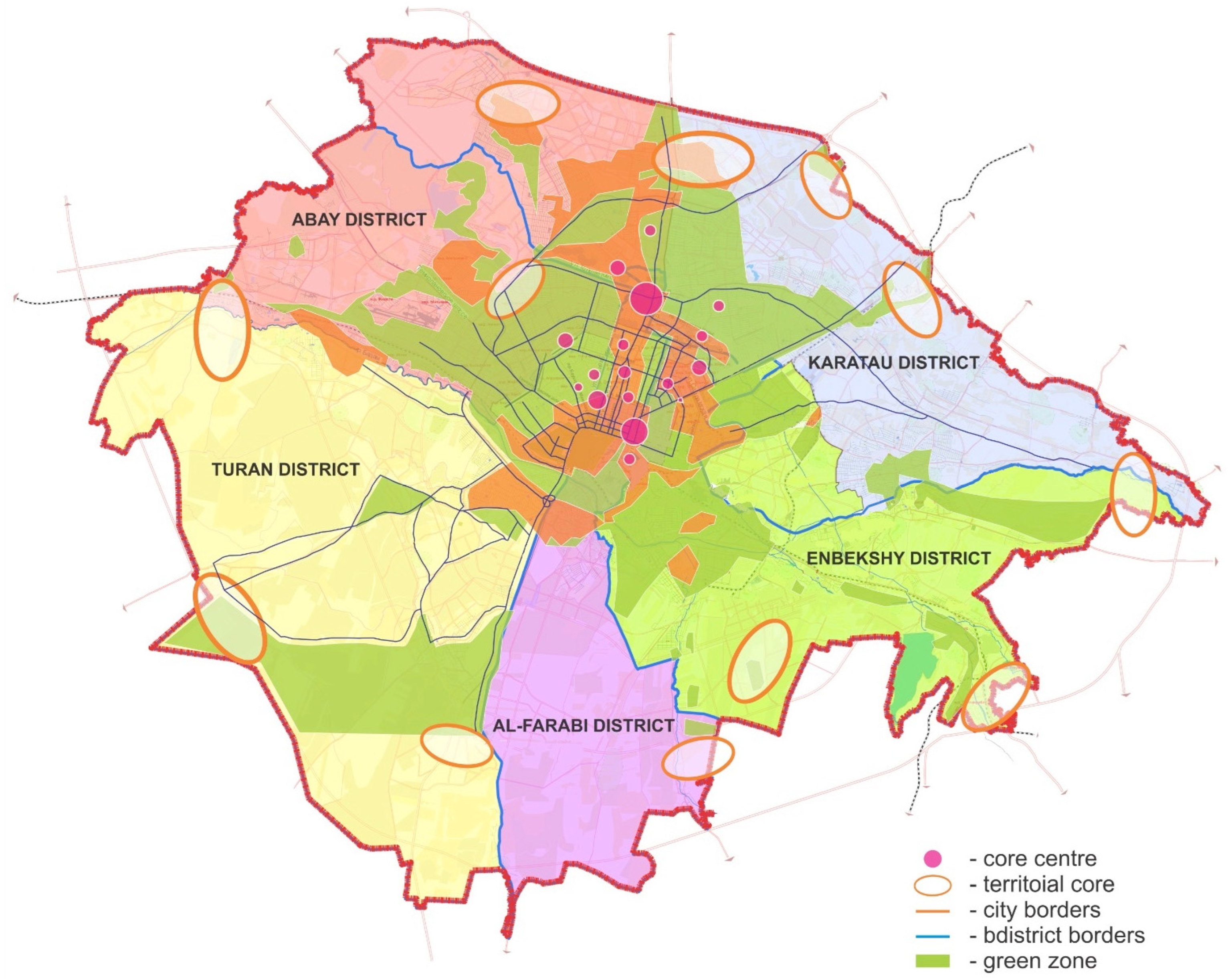
The metropolis structure was determined using the isochron method (1.5 h transport accessibility). Currently, Shymkent consists of five administrative districts: Abay, Enbekshy, Al-Faraby, Karatau, and Turan [
12].
The deputies of Shymkent Maslikhat approved and agreed on the boundaries of a new, fifth district of Shymkent city with a total area of 36.3 thousand ha in July 2022. This area is called Turan (
Figure 1 and
Figure 2).
It is possible to note the absence of clearly defined boundaries of residential, industrialized, and recreational areas when reviewing the city’s territorial structure. In total, 21% of the city’s territory consists of urban and suburban forests located on settlement lands which are intended for public recreation and environmental protection; 16% is a residential area, 18% is industrialized, 6.7% of the city’s total area is a recreation area, which is represented by gardens, arches, alleys and gardens according to the data from the Committee of Urban Advancement and Land Resources of Shymkent [
12].
Shymkent city is a developed multi-functional center of the processing industry, with the result that special importance is given to the industrialized zone (
Figure 3).
The city is among the top three in the country for the production of 18 manufactured goods, namely, essential oils, fabrics from synthetic staple fibers, woven textile fabrics and similar woven fabrics (except narrow fabrics) made of cotton, bars (rods) and solid profiles, cold drawn alloy steel (except stainless), plates and ceramic tiles, and so on.
In total, of 57 large and medium enterprises of promising production industries (15—construction materials production, 11—light industry, 10—food products, 8—metallurgy, 5—mechanical engineering, 4—pharmaceuticals), 54 of them export their products throughout the city. The largest investments in manufacturing are made in glass and glassware (41.8%), stone cutting, processing and finishing (13.5%), textiles (13%), cement, lime and gypsum (11.2%), clay-based building materials (10.6%), coke and petroleum refining products (9.9%), and metallurgical production (8.8%) [
13].
There is a steady upward trend in the volume of mineral extraction; for example, in 2017, mining increased by 15.1% compared to 2016. A special role in the city’s industrial structure is assigned to enterprises of metallurgical production, where at the end of 2017, there was a slight increase in production [
14,
15].
The transport, communication, and engineering communication lands are linear elements of the socio-economic and demographic infrastructure framework of a megapolis (
Figure 2). This category of land accounts for 5.5% (1453 ha) of the city area according to the data of the Committee for Urban Advancement and Land Resources in Shymkent.
Buses and taxis are used as urban and suburban transport. The city is surrounded by a ring road. There are various grade-separated crossings, four car bridges, and bypass roads around the center. The total length of roads in Shymkent is 2976.6 km. Of these: with asphalt—1758.1 km (59.1%); with gravel—1107.0 (37.2%); and natural road—111.5 km (3.7%)
The level of air pollution in the city is very high according to Kazhydromet data. Shymkent‘s environmental situation is significantly worsened by the city’s high industrialization, which includes the production of fuel and energy resources, water-related products, consumer complex industries, and related industries. The city ranks third in Kazakhstan in the field of waste generation, and is a leader in airborne chemical pollution [
16].
The general summary tables were compiled to identify prevailing winds by month and year, contributing to the territory’s environmental deterioration of the megapolis based on Kazhydromet reports, which reflect wind direction and strength by days and months (
Table 1 and
Table 2,
Figure 4).
The prevailing winds throughout the year are southwestern and southeastern, with north as well as south, and very rarely northwestern, western and eastern winds [
16].
Thus, the data obtained together with the wind roses show that the megapolis and its surroundings are affected by industrial enterprises: Shymkent city is in the list of polluted cities according to following substances: benz(a)pyrene, suspended solids, sulphur dioxide, hydrogen fluoride, nitrogen oxide, carbon monoxide and ammonia, as well as metals and specific impurities: formaldehyde, hydrogen sulfide, phenol, hydrogen cyanide. According to the obtained data, the MAC of benz(a)pyrene is exceeded by 5.8 times (
Table 3).
The average annual concentration of suspended solids decreased by 1.4 times to 0.7 MAC. The annual average concentrations of carbon monoxide and ammonia were increased to 0.5 MAC and 0.7 MAC, respectively. Concentrations of formaldehyde and phenol slightly decreased. The concentrations of sulphur dioxide and carbon (soot) have remained at the same level over the past three years.
There are maximum single concentrations of nitrogen dioxide and nitrogen oxide in the Al-Faraby area. The maximum of 4.4 MAC is in the Karatau area.
Thus, the average concentration of benz(a)pyrene during the five-year period (2019–2024) decreased by half (
Figure 5). The annual average concentration of hydrogen fluoride increased by 1.8 times. Atmospheric precipitation was 40% equilibrated, 29% neutral, 28% weak alkaline, and 3% weak acid [
17].
The socio-economic and demographic infrastructure and green infrastructure include a hydrological network as a linear element, so the state analysis of these elements is important. The Koshkar-Ata river and its tributaries are polluted by wastewater of industrialized enterprises based on hydrological studies.
Shymkent’s territory is strongly affected not only by industrialized enterprises, which are the main elements of the socio-economic and demographic infrastructure framework, but also by enterprises in adjacent areas. As a result, pollutants increase in air and water sources both within the city’s territory and outside of it.
This leads to degradation of environmental quality. It is possible to create green infrastructure that takes into account the study area specifics to maintain ecological equilibrium of the megapolis area [
18].
Green infrastructure is important, forming a complex green zone represented by a unified system of interconnected elements of the city’s landscape and surrounding areas for the enhancement of the green infrastructure of a megapolis.
The complex green zone consists of urban advancement areas and outer zones. The urban advancement area includes microdistricts, residential quarters, green plantations of various significance, greening of streets, roads, squares and greening of industrialized areas. It is typical for Shymkent city to be divided into six districts, each containing plantations of different significance: squares, alleys, boulevards, and parks. The area of common use is 530.54 hectares, which, as an organic component, includes the following: 6 parks—7.3%, 18 boulevards—6.5%, 71 squares—20%, street gardening—44.2%, based on the city’s master plan [
12].
The natural framing of a megapolis, represented by green infrastructure, should include the following principles: The main axes of the city’s natural framing should be a logical continuation of some elements of the district’s natural frame. Regarding the interconnectedness of the frame’s elements, the frame’s elements should penetrate into all the city’s most important structural links, namely, residential and industrialized areas and microdistricts. The frame’s functional relationship pursuant to the city’s specific natural and economic characteristics should be reflected in both frame structure and its biological characteristics, leading to simultaneous frame enhancement [
19].
Green infrastructure of the megapolis can be divided into the following elements: macro-structure represented by greenery; meso-structure represented by squares, boulevards located in all areas of the city, and greening of streets; micro-structure represented by lawns, flower beds, and shrubs (
Figure 6).
The micro-structure elements of the megapolis do not have a high environmental value overall.
The sketch map of the green infrastructure of Shymkent reflects the location of the macro- and meso-structures of the megapolis territory according to this division. The micro-structure covers the city’s green areas in relation to residential areas, industrialized areas, and transport links. Macro-structure will be created when drawing up the city master plan.
Shymkent is characterized by a mosaic macro-structure formed when rural settlements confluence with the city, as well as the location of production and expansion of inhabited territories. Areas with natural landscapes are preserved in the territory of the megapolis. They are located in the south and north of the city. The rest of the macro-structure area is represented by off-the-land development, rural settlements, and agricultural areas. The cooperative comprises the area of the forest–park green belt, represented by areas with restricted natural use and other economic activities, including areas on which forests, water bodies or parts thereof are located, natural landscapes, and green areas within boundaries of urban settlements that are adjacent to these forests or form a single natural ecological system with them and perform the reflexive, environmental, ecological, sanitary and recreational functions.
The meso-structure of the megapolis is represented by two types of handmade and naturally occurring areas. The meso-structure of man-made origin is represented by farmers, gardens in certain microdistricts, as well as planting along highways, which contributes to developing a unified system of the city’s meso-structure. The meso-structure of natural origin is represented by floodplain vegetation along river systems of the megapolis [
20].
It should be noted that the meso-structure of man-made type, due to its location in the city’s central part, is under permanent «man-induced press», unlike meso-structures of natural origin, both in the city’s central part, such as flood vegetation along river banks, and flood vegetation of small river channels in the suburban zone.
The specificity of territorial structure is taken into account, as well as the significantly developed industrialized orientation of the studied territory, when building the green infrastructure of the megapolis.
There is a confinement of medium-large massive (more than 25 ha) elements to the mesorelief (plains, lower terraces), or river valleys of rivers dividing the city in the territorial structure of Shymkent. The green belt surrounding the city is highly fragmented, and the central part of the city is quite green, in connection with Shymkent’s existing green infrastructure, which supports the riverine type with weak linkage of elements.
The forest landscape of the megapolis is represented by a green zone, uniting all forests in a radius of 30 km around the city, with a total area of about 22.5 thousand ha, or only 8% of the suburban area. The area of forest landscape in the Turan district is 30.68%, in the Enbekshy district is 18.85%, in the Karatau district is 16.25%, in the Abay district is 20.51%, and in the Al-Faraby district is 11.16%.
Very significant importance is given to the inhabited landscape, characterized by three indicators: the degree of greenery, the level of construction, and «stone» in the context of a megapolis [
20]. Most of the city’s territory is represented by residential and public buildings according to the statistical report of the city’s Committee on Land Use and Land Resources for 2018–2024. Between 2018 and 2024, the area of public-business advancement increased by 70 hectares, the area of transport, communication, and engineering communications increased by 44 hectares, and the NPA area also increased by 1 hectare. The area of land not involved in urban advancement or other activities decreased by 209 hectares.
The indicator analysis of megapolis landscape allows for highlighting a suburban-park type of inhabited landscape, characterized by maximum city greenery, «open» soils, relatively complex and faunistically rich biozones. Askarov Dendropark, located in the Central District, is the garden-park landscape of Shymkent city.
In addition, the green infrastructure of the megapolis includes rural inhabited landscapes as inter-trunk wedges, where there is a slight transformation of landscape complexes.
The main structural elements of green infrastructure are square and linear elements. Interaction between the main structural elements occurs through natural and man-induced corridors and inter-trunk wedges.
The first group of area elements (central core) is located in the central part of the microdistricts, with an average area from 5.3% to 90.6%. This group consists of seven central cores.
The first part of the central cores is located on the left bank of Koshkar-Ata river in Al-Faraby and Abay districts. The central area of the core is represented by square elements located in the city center, and represented by large parks. The total area of the central core of this area is 66.4 ha. The connecting objects between central cores are pitches represented by squares, boulevards, and alleys, as well as man-induced natural corridors represented by green plantings along highways.
The second part of the central core is located in the Enbekshy district and is represented by parks away from the city center.
The average area of the core is 19.5% to 146.8%. There is a lack of point elements, so the connection between the cores is carried out through natural corridors represented by river systems and man-induced natural corridors for the Enbekshy district. The area of the central core in the district is 33.3 ha.
The interrelationship of structural components of green infrastructure of these areas is carried out through point elements, as well as man-induced natural corridors.
The second group of surface elements (central core) of Shymkent is represented by natural areas with natural vegetation. The functions of central cores are made up of forest estates, with an area from 26.7% to 92.7%, as well as civil burial grounds, with a total area of 587 ha. The analysis of the position of the II group of area elements shows that the outer cores, like the central ones, are also unevenly located. The largest number of boundary cores is concentrated in the south of the city and they are represented by pine and mixed forests. There are central cores, represented by natural forests preserved within a 20 km zone in the city boundary in this area. They make up about 3500 ha of land.
The interrelation between boundary cores of green infrastructure of Shymkent is carried out through natural corridors represented by the network of rivers, Koschar-Ata, Sayramsu, and Aksu, as well as man-induced–natural corridors represented by green areas along motorways.
The inter-trunk wedges are of great importance in the green infrastructure of Shymkent. The average area is 1337.5 ha. This area is a reserve of green infrastructure, retaining the capacity for the establishment of a greening system. Inter-trunk wedges are the territories of garden and rural communities, as well as recreation areas.
Thus, 7 central and 12 boundary cores, connected to a single structure by natural and man-induced–natural environmental corridors, as well as inter-trunk wedges, are distinguished in the green infrastructure structure of Shymkent.
3. Results and Discussion
The universal algorithm of green infrastructure of a megapolis is a set of ecosystems that form a spatially organized infrastructure to maintain the ecological stability of the territory and preserve a favorable ecological situation in the city. When forming green infrastructure, many authors [
21,
22,
23,
24] rely on various principles: the principle of ecological corridors; the principle of buffer zones; the principle of landscape polarization; the principle of interpenetration of natural and economic infrastructure; the principle of individuality of natural conditions of each section of the territory; the principle of territorial integrity; the principle of relative simplicity of the device; the principle of openness; the principle of landscape diversity, etc.
When forming green infrastructure, many authors base their approach on the principle of relative simplicity of the device, based on the diversity of objects of natural territories and territories with a special legal regime, which form the basis of sustainable development of the territory and maintain the ecological balance of the region.
An analysis of the territorial structure of many cities shows the absence of a clear distinction between residential, industrial, and landscape–recreational zones. The residential zone of a megapolis is represented by residential areas related to the lands of public and business development. This territory is characterized by the presence of multi-story buildings with green spaces for public use adjacent to the industrial and landscape–recreational zone. “Green wedges” are represented by the greening of streets in the residential zone, are point elements in the structure of green infrastructure, and act as a screen from unfavorable winds or as a corridor for ventilation. Green spaces have a beneficial effect on maintaining the ecological balance of the city’s urban systems, being the basis of any natural landscape. Vegetation acts as an environment-restoring system that ensures comfortable living for people in a megapolis, regulating the gas composition of the air and the degree of its pollution, reducing the impact of the noise factor, and being a source of aesthetic recreation for people.
In a megapolis, the residential area directly borders on the industrial and landscape–recreational zones of the megapolis. The industrial zone is represented by industrial enterprises, public utilities, warehouses, engineering infrastructure facilities, and suburban and urban communication routes. This territory includes industrial and communications lands, as well as disturbed territories.
The landscape–recreational zone of a megapolis is represented by a suburban zone with natural green areas, which are reserve territories for development. This territory includes natural lands, public utilities, and external transport facilities, taking into account the possibility of convenient transport links. The landscape–recreational zone is of great importance for maintaining ecological balance and biodiversity.
An analysis of the territorial structure of a megapolis revealed that long-term economic use of the natural environment has led to a change in natural landscapes, natural–anthropogenic, anthropogenic–natural, and anthropogenic landscapes, as well as the disappearance of large natural territories as a result of direct interaction between residential, industrial and landscape–recreational zones.
The absence of natural lands in a megapolis contributes to the use of the following principles: the principle of territorial integrity, the principle of geoecological representativeness, the principle of openness, the principle of maintaining natural processes, and the principle of sustainability.
Let us consider how the existing principles of forming green infrastructure for a megapolis can be applied.
The principle of territorial integrity is implemented through transport infrastructure, which is a link connecting all zones into a single system.
Megapolises are characterized by the development of radial-ring and chessboard schemes of transport infrastructure. Analysis of administrative divisions shows that most megapolises are characterized by division into districts located at significant distances from each other. Thus, when forming a green infrastructure, green spaces located along highways and transport arteries are of great importance, allowing for maintaining territorial integrity. Green spaces play the role of linear elements (ecological corridors), connecting into a single system the structural elements of the ecological framework located in different areas of the city. This creates a continuous corridor of living nature capable of supporting biodiversity in the megapolis.
A megapolis is an urban system represented by natural and anthropogenic subsystems. As a result of the growth and development of a megapolis, there is an increase in the pressure of anthropogenic systems on the natural environment, which leads to the replacement of natural systems by anthropogenic ones. In this regard, great importance is given to ensuring environmental stability and maintaining ecological balance by introducing the entire diversity of natural systems and cultural landscapes into the structure of green infrastructure, which is a characteristic of the principle of geoecological representativeness.
An important principle of the formation of green infrastructure is the principle of openness, indicating the subsequent possibility of complication and branching of the structural elements of the framework. This process is possible as a result of the introduction of restored disturbed territories into the ecological framework, as well as territories where a change in natural systems occurs.
One of the features of a megapolis in a resource region is the absence of a system of large natural territories. Modern concepts and approaches to the formation of green infrastructure are based on the system of natural territories. In this regard, the construction of green infrastructure of a megapolis requires the allocation of new approaches based on the territorial characteristics of a megapolis. As a basis for the formation of the green infrastructure of megapolis, we propose the concept of “green infrastructure”.
“Green infrastructure” is defined by us as a set of parks, landscaped areas, and specially protected natural areas, as well as the entire set of undeveloped and unsealed spaces within the city limits. In the domestic school of urban planning, the concept of “green infrastructure” (or “green spaces”) is only just beginning to be used; the phrase “green plantings” is more familiar, which means a set of trees, shrubs, and herbaceous vegetation in a certain area.
The reduction of undeveloped spaces both in the suburbs and in the city itself contributes to the modification of their functions and often to a decrease in the comfort of the urban environment.
Improving the environmental situation in cities is associated with the improvement of the greening system, which is understood as a scientifically based spatial placement of all components of urban greening in accordance with urban planning zones, soil, climatic and other factors in order to achieve optimal environmental, sanitary and hygienic and aesthetic effects [
25]. In foreign urban planning practice, the concept of “green infrastructure” is used [
26,
27], which focuses on the ecological significance of the territory, considers the entire spectrum of landscape changes, and serves as the basis for the formation and development of the General Plan [
28].
The development of green infrastructure is aimed at preserving biodiversity, climate and water regulation, interception of surface water runoff and its purification, preservation and restoration of natural landscapes, creation of conditions for recreation near places of residence, reduction of the area of sealed soils, environmental education, and training of the population.
Natural landscapes in urbanized systems are interconnected elements of nature, opposed to the development, engineering, and technical systems of the city, as well as territories of anthropogenic origin.
Of great importance for a megapolis is the “restoration fund” that has undergone reclamation and restoration processes. The gradual restoration of disturbed lands contributes to the restoration of these territories to the natural system of management.
If the basis for the development of the city is industry, accordingly, the main factor of the settlement system is the degree of dispersion of factories and plants, the permissible time costs for the movement of an enterprise employee from the place of settlement to the place of work, as well as the possibility of implementing them using vehicles. Many cities are characterized by a decentralized settlement system based on the “factory–village” principle, characterized by the presence of small settlements with a population of 5 to 10 thousand people each. As a result, there is a close proximity of residential and industrial zones.
The peculiarities of the geographical location of cities make it possible to use a basin approach in the formation of green infrastructure. River systems within green infrastructure perform the functions of ecological corridors, as units for preserving the ecological integrity of existing ecosystems, and implementing material and energy connections between the structural elements of the green infrastructure.
Thus, the use of the above principles and approaches in the formation of the green infrastructure of a megapolis allows for the most complete analysis of the territory of the cities under study, taking into account all landscape and environmental features. These approaches and principles complement each other, which in turn ensures the sustainable development of the territory.
These principles and approaches are the basis for the formation of the green infrastructure of a megapolis in a resource region. The initial stage of green infrastructure formation is the analysis of the territorial structure, which allows for the allocation of residential, industrial, and landscape–recreational zones, as well as familiarization with the landscape diversity of the territory under study, and the determination of the specifics of a megapolis.
Let us consider the features of the allocation of cores, buffer zones, inter-highway areas, and point elements of the green infrastructure. The territorial structure of a megapolis shows that the formation of the green infrastructure occurs by connecting urban microdistricts through a system of ecological corridors connecting cores and point elements. In accordance with the above, the analysis of the territorial structure of urban microdistricts, where area and linear elements are allocated, is of particular importance. The analysis of the placement of area elements of urban microdistricts allows us to distinguish two groups of elements: the first group of area elements is located in the central part of the microdistricts, has a small area and is not rich in biodiversity, and the second group of area elements is located on the border of the district or city. Compared to the first group, it has a larger area and is rich in species diversity. On the territory of the microdistricts, even smaller elements are distinguished, such as alleys, flower beds, lawns, etc. In the creation of green infrastructure, they are considered point elements.
In general, for the territory of n megapolis, these territories perform environment-stabilizing, environment-protecting functions and are the basis for the long-term functioning of ecosystems in the mode of natural dynamics.
Linear elements connect all area elements into a single system, which allows us to distinguish, based on location, group I of area elements as central cores, and group II as marginal cores.
Central cores, supporting the ecological stability of the city-forming system, are territories with a greening system, which is characterized by small sizes. These territories affect only the surrounding area and perform mainly an environment-forming function. From the point of view of biological diversity, the central cores have relatively poor biodiversity. In the green infrastructure of a megapolis, the central cores are large parks and squares of the city, natural monuments, and large city cemeteries located in the central part of the city.
Marginal cores, located on the outskirts of the city, have the largest area, and are characterized by high biological diversity. It is the marginal cores that are the source of biodiversity when disturbed at the local level, and also those that participate in the regulation of the basic parameters of environmental stability. In the conditions of the green infrastructure of a megapolis, the marginal cores are natural monuments located on the outskirts of the city, as well as the green zone along its perimeter. The protective forest belt formed by the marginal cores performs environmental protection, sanitary and hygienic recreational, and economic functions. The green zone includes forests located at a distance that can be covered by public transport used by city residents for mass recreation.
A megapolis is an open system, as a result of which the peripheral cores are not only a source of oxygen for the central part of the city, but also a protective barrier from emissions from industrial enterprises in the territories bordering the city. Linear elements contribute not only to the formation of a single system but also to the exchange of matter and energy between urban microdistricts. The integrity of the green infrastructure is maintained by a green zone located along highways.
Thus, it is possible to distinguish two types of linear elements for the green infrastructure of a megapolis:
River systems (natural linear elements) that perform a transport function, ensuring the movement of mobile components of nature, the protection of river channels and floodplains, including maintaining the integrity of the framework;
Green strips of highways (anthropogenic–natural linear elements) that perform an environmental protection function.
There is an increase in the number of plant and animal species adapting to the natural and anthropogenic landscape of megapolises due to the migration capacity of ecological corridors. The formation of agglomeration, a fairly complex dynamic system with intensive production, transport, labor, and cultural and everyday connections, allows us to talk about the transition of living beings to coexistence with humans, i.e., an increase in suburbanization. As a result, changes in the natural vegetation, wildlife, and the emergence of new synanthropic species of plants and animals are observed on the territory of megapolises. As the city grows and develops, voids of development and quarries are formed, which are inter-highway wedges in the structure of green infrastructure, represented by a rural residential landscape with an insignificant transformation of complexes. As a result of the increase in the area of urbanized territories, it is important to preserve the possibility of restoring the greening system.
Inter-highway wedges act as multifunctional territories that complement ecological cores and ecological corridors, sometimes separating them from man-made territories (i.e., partially carrying out the functions of buffer zones).
The green infrastructure of a megapolis includes point elements that unite a wide variety of objects and are distinguished by their small size. At the same time, the main task of point elements is to protect unique objects of nature and material culture that perform economic, aesthetic, and social functions. Regarding the conditions of a megapolis, the point elements of the green infrastructure include the following: district parks, squares, boulevards, local areas, as well as some historical and cultural monuments. Important elements in the formation of the green infrastructure of a megapolis are territories that protect ecological corridors and ecological cores from adverse external influences—buffer zones. These territories are necessary to ensure additional sustainability and minimize external impacts on the elements of the green infrastructure of a megapolis.
The area of green areas for common use should be 1359.0147 m2 (1359 ha), taking into account the population of Shymkent. Currently, the area of green areas is 7.4 m2 per citizen. This is almost 70% less than required by the norm.
Shymkent city is the largest megapolis; therefore, it is important to effectively perform the environmental protection function. The analysis of the dust and noise protection function was carried out to assess the performance of the environmental protection function. Industrialized and exhaust air purification is more efficiently performed by forest complexes.
Research on the dust-holding role of tree and shrub plantations shows that air dusting in greenhouses is 40% lower than in open or built-up areas.
Active advancement of transport infrastructure and industrialized production indicates an increasing level of noise that has a negative impact on human health.
Different species of plants have different noise protection capabilities. According to Hungarian researchers, coniferous trees regulate noise better than broad-leaved trees. As the trees are removed from the highway by 50 m, deciduous trees reduce the sound level by 4.2 db, deciduous shrubs by 6 db, spruce by 7 db, and pine by 9 db. On average, the crowns absorb 25% of sound energy, and approximately 75% of this energy is reflected and dispersed. The grass cover also helps to reduce the sound level by 5–7 dB [
29].
In Shymkent, the green area along roads is represented by a regular grass plantation with open-topped space, as a result of which noise is not absorbed and is reflected repeatedly and folded into sound waves, creating a kind of sound corridor between the ground surface and the underground crown. The noise protection function is enhanced by supplementing the second row of plants. The best result is given by plants with a large vertically located source of leaves, as well as with a large number of shoots and branches that serve as a protective shield. Free-growing, non-formed live fences are of particular importance; they absorb more noise than narrow-shaped live fences, but they require more space. For maximum improvement of the noise protection function, it is possible to use mixed plantings using conifers (spruce, arborvitae, pine). Of the number of deciduous trees, the following broadleaf species: maple, leek, willow, ash, and poplar, are the most effective noise-retardants. Among the tall shrubs, the choice stops on hawthorn trees, Hornbills, Calendula viburnifolious vesiculaceae (Physocarpus opulifolius), and Caragana arborescens (C. arborescens).
Location analysis of Shymkent’s green zone indicates that the green zone is scattered throughout the city by green «spots», unevenly located along roads. We also note the absence of a water–green diameter, connecting central areas with the green belt of the city. It is proposed to supplement the existing green infrastructure of Shymkent city with additional elements as a result of the high man-induced load on megapolis landscape for optimal functioning [
30].
The analysis of architectural and planning features of residential areas of Shymkent reveals the complexity of creating new facilities. This problem is particularly acute in the Central Region, while there are broad prospects to create additional elements of green infrastructure in the Turan and Al-Faraby districts.
It is recommended to supplement the existing green infrastructure of Shymkent city with the following elements to improve green infrastructure (
Figure 7).
Central core in the form of square in Abay, Al-Faraby and Turan districts; point elements in Abay and Enbekshy districts; boundary cores in “Altyn Dan” connecting Karatau and Turan districts, preventing penetration of northwestern winds carrying pollutants from industrialized zone enterprises; boundary core “Juldyz”, which contributes to the formation of natural barrier, preventing penetration of harmful substances from industrialized enterprises.
- -
Boundary core “a” is located in the north of the city in Abay district;
- -
Boundary core “b” is located in the northeast of the city in Turan district, preventing the penetration of pollutants from Shymkent-ferro-alloys enterprises, HPP-2;
- -
Boundary core “c” is located in the south of the city;
Based on the geographical principle, it is proposed to create a parking area in the territory of “d”, “e”, “f”, “g”, and “h”. On the territory of boundary cores “j”, “k”, “l”, recultivation works are to be carried out.
Increasing the area of green spaces in the form of central cores and point elements will improve the microclimate, the amount of dust absorbed, and increase noise absorption in the urbanized area.
The green infrastructure of Shymkent is proposed to be supplemented with ten boundary cores, as well as seven central cores in Al-Faraby and Abay districts, as well as seven point elements. The increase in green space is proposed to be carried out by different types of plantings: For Shymkent city, as for other cities with hot climate, the choice of types of green spaces should take into account climatic conditions, drought resistance and the ability of plants to filter the air and create comfortable conditions for citizens. The following are some types of green spaces that can be used for Shymkent city: Trees: Poplar (Populus)—adapts well to various conditions, grows quickly, and forms a dense shade; Maple (Acer)—drought-resistant species, such as sycamore maple, can be used for landscaping. Ash (Fraxinus)—these trees are also resistant to hot climates and have good decorative qualities. Acacia (Robinia) is widely used for landscaping in the southern regions. It is distinguished by its high decorative qualities and shade. Oriental plane (
Platanus orientalis) is a tree that is highly resistant to heat and dust, which makes it an excellent option for the urban environment [
31].
Shrubs: Rosehip (Rosa) is an ornamental shrub with beautiful flowers and fruit formations. Cade (Juniperus) is a drought-resistant plant that is perfect for creating ornamental hedges. Barberry (Berberis) is a shrub that adds bright colors to the landscape and tolerates hot climates well. Lavender (Lavandula) is an aromatic shrub that also attracts beneficial insects and is drought-resistant.


 ,
, 


