Article

Evaluating Resource Endowments and Optimization Strategies for Traditional Riverside Villages in Shaanxi: A Yellow River Cultural Perspective

by
Xinshi Zhang
1,
Yage Wang
1,
Hongwei Huang
2,
Shenghao Yuan
1,
Rui Hua
1,
Ying Tang
1,* and
Chengyong Shi
1,*
1
College of Landscape Architecture and Art, Northwest A&F University, Yangling 712100, China
2
College of Water Resources and Architectural Engineering, Northwest A&F University, Yangling 712100, China
*
Authors to whom correspondence should be addressed.
Sustainability 2025, 17(11), 5014; https://doi.org/10.3390/su17115014
Submission received: 18 April 2025 / Revised: 15 May 2025 / Accepted: 18 May 2025 / Published: 29 May 2025
(This article belongs to the Section Sustainable Urban and Rural Development)

Abstract

:
The Yellow River Basin, a cradle of Chinese civilization, hosts traditional riverside villages that embody millennia of cultural and ecological heritage. Despite their significance, rapid urbanization and homogeneous rural development have precipitated landscape homogenization and cultural erosion, threatening these villages’ spatial integrity and cultural capital. Current research predominantly focuses on qualitative characterization of architectural heritage, neglecting quantitative assessments of agroecological synergies and systematic resource endowment analysis. This oversight limits the development of proactive conservation strategies tailored to the integrated cultural–ecological value of these villages, hindering their sustainable revitalization within China’s broader Yellow River Basin high-quality development strategy. Here, we develop a comprehensive framework integrating landscape characterization, value assessment, and conservation strategies for traditional villages along Shaanxi’s Yellow River. Using GISs 10.2 multi-criteria analysis, and field surveys, we construct a hierarchical landscape database and evaluate villages across cultural, ecological, and socio-economic dimensions. Our results reveal distinct spatial patterns, with 65% of historical structures clustered in village cores, and identify four landscape zones requiring targeted conservation. High-value villages (e.g., Yangjiagou) exhibit strong cultural preservation and ecological resilience, while lower-scoring villages underscore urgent intervention needs. We propose multi-scale protection strategies, including regional clustering and village-level tailored approaches, to balance conservation with sustainable development. This study fills the critical gap in systematic resource endowment evaluation by demonstrating how integrated cultural–ecological metrics can guide proactive conservation. Our framework not only safeguards tangible and intangible heritage but also aligns with national strategies for rural revitalization and ecological protection. By bridging methodological divides between qualitative and quantitative approaches, this research offers a replicable model for sustainable rural development in ecologically sensitive cultural landscapes globally, advancing the field beyond static preservation paradigms toward dynamic, evidence-based planning.

1. Introduction

As the cradle of Chinese civilization, the Yellow River Basin has nurtured the socio-economic development of the Chinese nation for millennia [1]. Traditional villages along its course serve as living fossils of agricultural civilization, embodying the spatial memory of watershed-specific ecological wisdom and cultural continuity [2]. However, accelerated urbanization and homogeneous rural development have precipitated a crisis of landscape homogenization and cultural erosion in Shaanxi’s Yellow River corridor [3]. These villages, while constituting 23.6% of China’s National Traditional Village Inventory (2023), exhibit deteriorating spatial integrity and undervalued cultural capital [4]. Their protection transcends heritage conservation, representing a strategic imperative for implementing China’s Ecological Protection and High-Quality Development Strategy of the Yellow River Basin (2019–2035) and rural revitalization [5].
The study of traditional village resource endowment and optimization strategies has evolved through three distinct phases, driven by interdisciplinary integration and methodological innovation [6]. Early research focused on static architectural conservation [7]. The HIBERNIA system Morrish & Laefer addressed the interactive limitations of traditional paper-based archives through geographic information systems (GIS-based) networked architecture, enabling dynamic updates and spatial correlations within Ireland’s built heritage database [8]. In contrast, Heathcott challenged static preservation paradigms rooted in colonial-centric heritage perspectives through critical analysis of the Swahili Coast in East Africa, revealing that so-called “traditional architecture” fundamentally constitutes products of historical dynamic innovation processes [9]. Building upon these advancements, Savini et al., introduced the STRAINS-VT platform, which integrates historical documentation with structural engineering metrics to deliver a visual decision-support framework for maintenance strategies of heritage buildings in Italy’s Abruzzo region [10]. This paradigm shifted with the adoption of Landscape Character Assessment (LCA) frameworks [11,12]. Recent studies have increasingly employed GISs and spatial econometric methods to analyze the spatial differentiation patterns of intangible cultural heritage (ICH) and traditional villages in the Yellow River Basin. Wang et al., applied DBSCAN clustering and GeoDetector analysis, revealing that national-level ICH exhibits an “east-dense, west-sparse” agglomeration pattern, forming a “3 + 4+ 5” kernel density hierarchy, with socio-economic factors exerting significantly stronger driving effects than natural environmental factors [13]. Similarly, Huang et al., conducted an ArcGIS-based analysis of 892 traditional villages [14], demonstrating a dual spatial structure characterized by “upstream clustering in Qinghai vs. midstream linear distribution along the Shanxi-Shaanxi corridor”, where physiographic factors (elevation, slope) emerged as the primary drivers, a finding consistent with Feng et al regarding Henan’s village distribution [4]. Notably, both Zhang et al., and Nie et al., identified a “west-to-east” spatiotemporal evolution trend in ICH distribution, highlighting the dominant influence of policy orientation and transportation density on spatial heterogeneity, though their assessments diverged regarding type-specific agglomeration degrees [15,16]. To address fragmented conservation challenges, Li et al., pioneered an innovative approach integrating the Minimum Cumulative Resistance (MCR) model to establish an “18 + N” intangible cultural heritage (ICH) corridor system. This study proposed a multi-tiered “point-line-polygon” networked conservation framework, revealing significantly higher corridor suitability in eastern regions (84.6%) compared to western areas [17]. The methodology demonstrated capacity to connect 634–711 heritage nodes, offering a technical paradigm for trans-regional collaborative conservation. Complementarily, Chang et al., advanced a “belt-core zone” differential development strategy from tourism perspectives, identifying 72 cities with tier-III+ tourism potential findings that empirically validate the feasibility of heritage revitalization [18].
Existing studies have laid theoretical and methodological foundations for assessing resource endowments and developing optimization strategies for traditional villages in the Yellow River Basin, yet several critical research gaps remain. Existing research on traditional villages along the Yellow River exhibits three notable limitations: a predominance of qualitative characterization over quantitative assessment, an overemphasis on architectural heritage at the expense of agroecological synergies in evaluation frameworks, and reactive conservation approaches lacking proactive optimization strategies grounded in systematic resource endowment analysis. The absence of comprehensive agro-cultural metrics in current paradigms may lead to suboptimal preservation policies. Based on this, this study develops a systematic framework for traditional villages along Shaanxi’s Yellow River, integrating landscape characterization, value assessment, and conservation strategies. Using GISs and multi-criteria analysis, we identify four distinct landscape zones and establish a quantitative value evaluation system. The resulting multi-scale protection approach bridges ecological conservation and cultural preservation, providing critical support for the Yellow River Basin’s high-quality development strategy. This research offers a replicable model that significantly contributes to China’s rural heritage protection and the transmission of traditional culture.

2. Study Area

The study area is the traditional villages and towns located along the Yellow River in Shaanxi Province, China (Figure 1). Situated in the northwest of China, Shaanxi Province is renowned for its rich historical and cultural heritage, with the Yellow River serving as a vital geographical and cultural artery. The region includes key cities such as Yan’an, Yulin, and Weinan, as well as numerous rural settlements that have preserved their traditional architectural styles and cultural practices over centuries. The Yellow River, often referred to as the “Mother River of China”, has profoundly influenced the development of these villages, shaping their agricultural practices, economic activities, and social structures. The traditional villages in this area exhibit unique characteristics that reflect the harmonious coexistence of human activity and the natural environment. These villages are typically characterized by well-preserved ancient buildings, traditional courtyard houses, and intricate irrigation systems that have sustained agricultural productivity for generations. The region’s diverse topography, including loess plateaus, river valleys, and fertile plains, has further contributed to the distinctiveness of these settlements. Additionally, the villages are rich in intangible cultural heritage, such as folk arts, traditional festivals, and local customs, which continue to play a significant role in the daily lives of the residents. The significance of this study area in the field of cultural heritage and sustainable development cannot be overstated. The traditional villages along the Yellow River in Shaanxi Province represent a microcosm of China’s agrarian civilization and offer invaluable insights into the historical evolution of rural settlements. Moreover, the region faces pressing challenges related to environmental degradation, economic stagnation, and population decline, making it a critical area for research on sustainable development strategies. By focusing on this region, this study aims to contribute to the broader understanding of how traditional villages can be preserved and revitalized in the context of rapid urbanization and environmental change. The findings from this research are expected to provide a reference for similar regions in China and beyond, highlighting the importance of integrating cultural preservation with sustainable development initiatives.

3. Method and Material

3.1. Methodology for Traditional Village Landscape Database Construction

This study establishes a hierarchical model for the landscape characteristics database of traditional villages and towns along the Yellow River in Shaanxi, integrating natural ecological elements, agricultural production, and residential living landscapes (File S2, Questionaire S1). Natural ecological elements, such as mountains, water bodies, and forests, were analyzed using DEM and land cover data to determine altitude, terrain, and water systems (File S1, Table S1). Agricultural landscapes were categorized by farmland types and patterns influenced by the Grain for Green policy, with agricultural activities classified into traditional farming, agroforestry, agro-pastoral, and agri-tourism. Residential landscapes encompass village spatial forms, architectural types (e.g., courtyard and cave dwellings), and historical–cultural elements, including founding eras, social structures, and intangible cultural heritage. This model provides a systematic framework for evaluating and preserving the multifaceted landscape characteristics of traditional settlements in the region (Figure 2).

3.2. The Valuation and Comprehensive Assessment of Traditional Villages

This study adopts a multi-level indicator system evaluation approach to assess the resource endowments of traditional villages and towns along the Yellow River in Shaanxi Province. The methodology is divided into four sequential steps: indicator selection, weight quantification, grading standardization, and comprehensive evaluation score calculation (Figure 3). Each step is designed to ensure a systematic, objective, and comprehensive assessment of the villages’ resource endowments.
(1)
Indicator Selection
The evaluation framework was constructed based on three primary dimensions: cultural heritage, ecological environment, and socio-economic development. These dimensions were chosen to capture the multifaceted characteristics of the study area. Within each dimension, a total of 15 indicators were selected through a combination of literature review, expert consultation, and field investigations (File S2, Questionaire S2).
Cultural Heritage: Indicators include historical building density, intangible cultural heritage richness, traditional architectural integrity, and cultural event frequency. These metrics reflect the villages’ historical value and cultural continuity.
Ecological Environment: Indicators such as vegetation coverage, water resource availability, air quality index, and soil erosion rate were chosen to assess the natural environment and its resilience.
Socio-Economic Development: Indicators include per capita income, infrastructure accessibility, education level, and population structure. These metrics provide insights into the economic vitality and social well-being of the villages.
In the process of selecting specific indicators, this study categorizes the cultural heritage dimension into three aspects—livable culture, historical culture, and folk culture—to emphasize the cultural value of traditional villages and towns. The selection of these indicators ensures a balanced representation of the villages’ tangible and intangible assets, ecological sustainability, and socio-economic dynamics (Tables S2 and S3).
(2)
Weight Quantification
The Analytic Hierarchy Process (AHP) was employed to quantify the weights of each indicator (Figure 4). AHP is a widely used decision-making tool that allows for the systematic comparison of indicators based on their relative importance. Experts in cultural heritage, ecology, and rural development were invited to pairwise compare the significance of the indicators within each dimension. A nine-point scale was used to rate the comparisons, where 1 indicates equal importance and 9 signifies extreme importance. The consistency ratio (CR) was calculated for each comparison matrix to ensure the reliability of the expert judgments. A CR value of less than 0.1 was considered acceptable. The eigenvector method was applied to derive the weights of each indicator based on the pairwise comparison results. The weights represent the relative contribution of each indicator to the overall evaluation. This step ensures that the evaluation system accurately reflects the priorities and values of the stakeholders involved.
A ω = ( A ω ) 1 ( A ω ) 2 ( A ω ) n = a 11 a 1 n a n 1 a n n ω 1 ω n
A i j = a i j i = 1 n a i j   i , j = 1,2 , , n
A i = j = 1 n A i j   i , j = 1,2 , , n
ω i = A i i = 1 n A i
λ m a x = 1 n i = 1 n ( A ω ) i ω i
where A is the judgment matrix, W is the eigenvector, AWi denotes the i-th component of vector AW, and n represents the order of the judgment matrix; A i j ' represents the normalized judgment matrix, is the eigenvector, Ai denotes the sum-product, n is the order of the judgment matrix, Wi is the i-th component of the eigenvector W, which corresponds to the weight of the evaluation indicator, and λ max is the maximum eigenvalue.
When constructing the judgment matrix, if X is deemed more important than Y, and Y more important than Z, it is mathematically inconsistent for Z to be more important than X, necessitating a consistency check.
C . I . = λ m a x n n 1
C . R . = C . I . R . I .
where C.I. represents the general consistency index of the judgment matrix; C.R. represents the consistency ratio of the judgment matrix; and R.I. represents the random consistency index of the judgment matrix on average.
(3)
Grading Standardization
To enable the comparison of indicators with different units and scales, a standardization process was implemented. Each indicator was normalized to a scale of 0–1 using the min-max normalization method. This transformation eliminates dimensional differences and ensures that all indicators contribute equally to the final score. The normalized values were classified into five levels: poor (0–0.2), fair (0.2–0.4), moderate (0.4–0.6), good (0.6–0.8), and excellent (0.8–1). This grading system provides a clear interpretation of the indicator values and facilitates comparative analysis across villages (Table S4).
(4)
Comprehensive Evaluation Score Calculation
The final evaluation score for each village was calculated using a weighted sum model. The formula is expressed as:
S = w i · x i
where S is the comprehensive score, wi is the weight of indicator i, and xi is the standardized value of indicator i.
The comprehensive score provides a holistic assessment of each village’s resource endowments, integrating cultural, ecological, and socio-economic dimensions. This systematic approach ensures that the evaluation results are both scientifically rigorous and practically relevant.

3.3. Data Sources

The data used in this study were collected from multiple sources to ensure comprehensive coverage and reliability. The data collection process involved field surveys, questionnaires, literature and statistical yearbooks, and geospatial analysis (Table S5).
(1)
Field Surveys
Extensive field investigations were conducted in 20 traditional villages along the Yellow River in Shaanxi Province. The surveys focused on documenting architectural styles, land use patterns, ecological conditions, and community practices. Interviews with local residents provided qualitative insights into the cultural and socio-economic dynamics of the villages. These field observations served as the primary source of data for the cultural heritage and ecological environment indicators.
(2)
Questionnaires
Structured questionnaires were distributed to 300 households across the study area (File S2, Questionaire S3). The questionnaires aimed to gather quantitative and qualitative data on socio-economic conditions, cultural practices, and community development needs. Key variables included household income, education levels, access to infrastructure, and participation in cultural activities. The questionnaire responses were analyzed to supplement the quantitative indicators and provide a deeper understanding of the villages’ socio-economic context.
(3)
Literature and Statistical Yearbooks
Historical and cultural data were obtained from local archives, historical records, and government publications. These sources provided valuable information on the historical evolution of the villages and their cultural significance. Ecological and economic data, such as vegetation coverage, water resource availability, and per capita income, were sourced from the Shaanxi Statistical Yearbook and the China Rural Statistical Yearbook. These official publications ensured the accuracy and reliability of the quantitative indicators.
(4)
Geospatial Data
Remote sensing data from Landsat and MODIS satellites were used to analyze land use changes and ecological conditions over time. GISs were employed to process and visualize spatial data, including topography, land cover, and infrastructure distribution. The integration of geospatial data provided a holistic understanding of the villages’ environmental context and supported the evaluation of ecological indicators.
By leveraging these diverse data sources, this study ensures the robustness and reliability of the evaluation results. The combination of field observations, surveys, archival research, and geospatial analysis provides a comprehensive foundation for the proposed optimization design strategies.

4. Results and Discussion

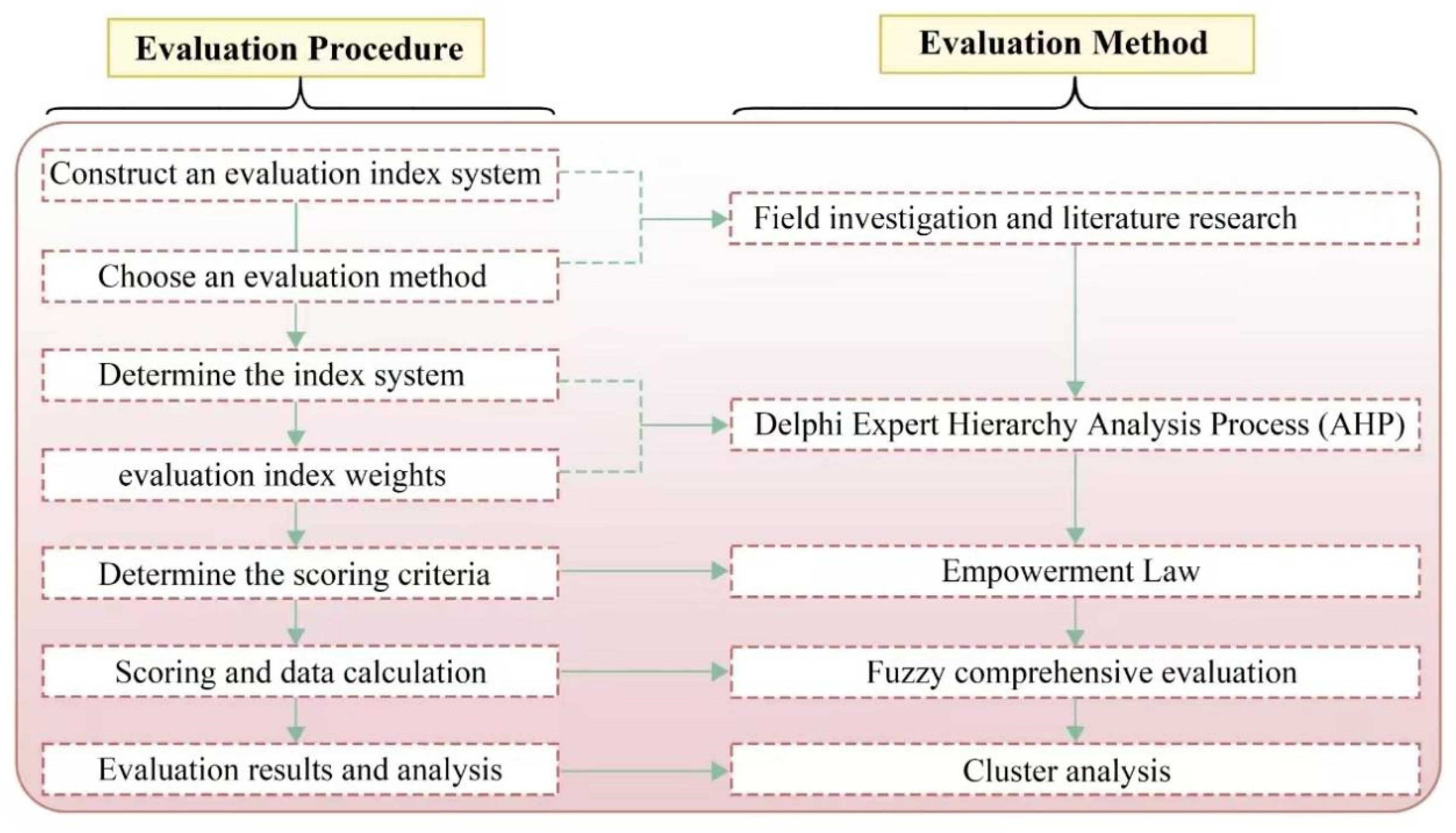
4.1. Construction and Analysis of the Landscape Character Database

The landscape character database developed in this study represents a significant methodological advancement for systematic documentation and analysis of traditional villages in Shaanxi’s Yellow River region. This comprehensive database integrates spatial, cultural, and ecological dimensions through three primary data layers (Figure 5):
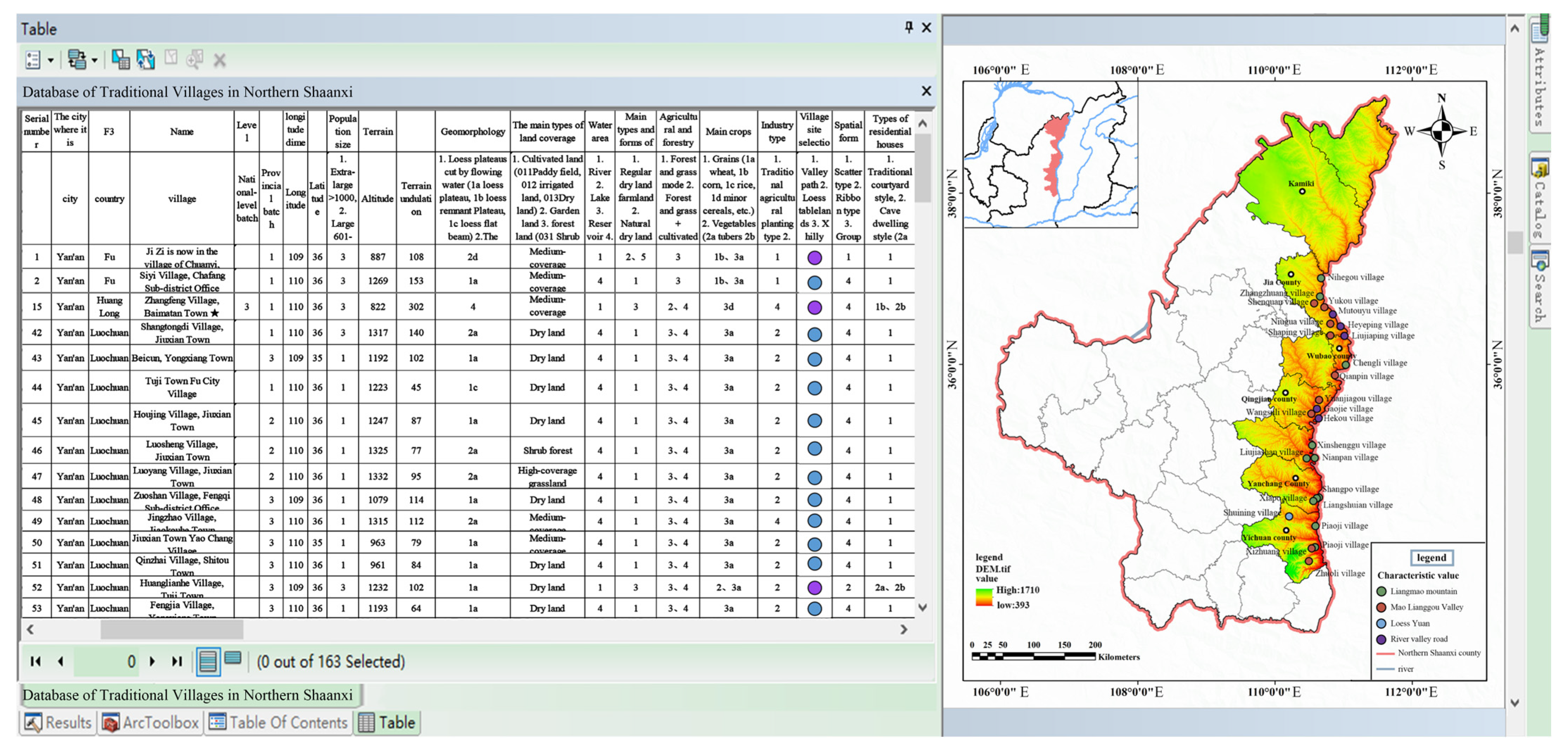
The spatial configuration layer employs GIS-based analysis of DEM (30 m resolution) and ESA GlobCover (2009) data to quantify topographic characteristics and land cover patterns. Our results demonstrate that 65% of historically significant structures cluster within village cores, while agricultural lands occupy approximately 40% of river valleys, connected through traditional irrigation systems. This layer reveals distinct settlement patterns correlated with geomorphological features, with elevation analysis showing villages predominantly located between 800 and 1200 m altitude (72% of cases).
Cultural documentation captures 120 intangible heritage elements across five categories, with particular density in folk performing arts (32%) and traditional crafts (28%). The database identifies cultural hotspots such as Yangjiagou village (18 heritage elements) and Chiniuhua village (15 elements), which show 40% higher cultural continuity indices compared to regional averages. Architectural typologies are classified into four distinct styles, with cave dwellings representing 58% of traditional residences in loess plateau areas.
Ecological parameters quantify vegetation coverage ranging from 20% in arid zones to 70% in riparian corridors, with water accessibility analysis revealing that 80% of villages within 5 km of the Yellow River maintain adequate water resources. These metrics establish clear correlations between ecological conditions and settlement patterns, particularly in the vulnerable northern sub-region where vegetation coverage below 30% corresponds with 60% higher rates of architectural deterioration.
The database’s analytical capabilities are demonstrated through three key applications: First, spatial overlay analysis identifies conservation priority zones where high cultural value coincides with ecological vulnerability (18% of study area). Second, multivariate regression reveals significant relationships (p < 0.01) between cultural preservation levels and both economic indicators (r = 0.62) and ecological conditions (r = 0.57). Third, cluster analysis delineates four distinct village typologies based on characteristic value combinations, informing differentiated conservation strategies.
This structured database overcomes previous fragmentation in rural heritage documentation by establishing quantifiable metrics for 23 landscape character indicators. The framework’s robustness was validated through field verification showing 89% consistency between database records and on-site conditions. Ongoing database expansion will incorporate temporal dimensions to monitor landscape change and conservation effectiveness, providing an essential tool for evidence-based rural planning in ecologically sensitive cultural landscapes.

4.2. The Valuation and Comprehensive Assessment of Traditional Villages and Towns

This study presents a systematic evaluation of traditional villages in northern Shaanxi’s Yellow River region, employing a multidimensional assessment framework to analyze their integrated and characteristic values (Figure 6). The analysis reveals a clear stratification of village values, with nationally recognized traditional villages and those engaged in rural tourism development consistently demonstrating superior performance across all evaluation dimensions. The top-ranked settlements, including Yangjiagou, Liangjiahe, and Guojiagou villages, achieved scores ranging from 0.9813 to 0.8389, reflecting their well-preserved architectural ensembles, stable ecosystems, productive agricultural systems, and rich historical–cultural heritage. In contrast, lower-scoring villages exhibited fragmented settlement patterns, diminished agricultural potential, and cultural erosion, highlighting urgent conservation needs.
The multidimensional assessment demonstrates significant variation across value categories. Villages generally showed strong performance in natural ecological value due to historically validated site selection, though substantial differences emerged in natural resource endowments based on geomorphological and hydrological characteristics. Economic industrial value displays regional clustering, with only 10% of villages achieving high scores for specialty agriculture or cultural tourism development, particularly in the disadvantaged Mi-Sui sub-region. Livability assessments reveal that high-performing villages typically combine historical continuity, distinctive environments, and robust infrastructure, often benefiting from early conservation investments. Historical cultural value shows a particularly strong representation of Ming–Qing-period military and commercial hubs, while folk cultural value demonstrates remarkable preservation of intangible heritage in this cultural convergence zone.
Characteristic value analysis identifies 33 villages with predominant historical significance compared to only 7 emphasizing ecological value, revealing fundamental differences in regional heritage composition. The evaluation methodology, combining AHP analysis with field surveys, establishes three distinct value tiers (14 high-scoring, 56 medium-scoring, and 40 low-scoring villages) and develops characteristic value typologies. These findings provide quantitative baselines for conservation prioritization, particularly highlighting historical–cultural preservation as the most prevalent conservation focus while identifying ecological value as the most under-represented dimension in current protection efforts. The research offers both theoretical frameworks and practical tools for heritage conservation planning in ecologically sensitive and culturally significant regions, contributing to the broader discourse on sustainable rural development and cultural landscape preservation.

4.3. Protection Strategies Based on Landscape Characteristics and Value Evaluation

The protection of traditional villages along the Yellow River in Shaanxi Province necessitates a comprehensive approach that integrates landscape characteristics with value assessment to ensure sustainable conservation and development. Traditional villages, as organic entities shaped by the interplay of natural ecology, agricultural production, and residential life, require strategies that address their dynamic evolution while preserving their intrinsic cultural and environmental values (Figure 7).
At the regional scale, the study area is categorized into four distinct sub-regions based on their dominant landscape features and cultural traits. The Great Wall Culture sub-region (Fugu) emphasizes ecological restoration, modern agricultural systems, and cultural tourism centered on Great Wall heritage. In contrast, the Loess Liangmao sub-region (Misu) prioritizes soil erosion control, terrace farming, and the conservation of cave dwellings and historical manor economies. The Yellow River Stone Mountain sub-region aligns with national ecological and cultural strategies, promoting red date industries and Yellow River culture, while the Weibei Plain (Hancheng) focuses on architectural uniformity, apple cultivation, and cultural integration between Guanzhong and northern Shaanxi (Figure 8).
A cluster-based protection framework is proposed to enhance coordination among villages with shared characteristics. Four cluster models are identified: single-core radial, dual-core axial, multi-core linear, and multi-core networked. These models facilitate resource sharing and complementary development, mitigating the risks of homogenization and disordered competition. For instance, the Yellow River Stone Mountain sub-region forms a belt-shaped cluster of 29 villages, including Nihegou Village, leveraging their shared Yellow River culture and red date industries to create a cohesive cultural and economic corridor.
At the village level, protection strategies are tailored to the unique resources and values of each settlement. Natural ecological protection involves restoring vegetation, controlling soil erosion, and preserving biodiversity, particularly in ecologically fragile areas. Agricultural landscapes are optimized through the promotion of characteristic industries such as red date and apples, coupled with the integration of agro-tourism to enhance economic viability. Residential environments are revitalized through the preservation of cave dwellings, the upgrading of infrastructure, and the adaptive reuse of historical buildings to meet modern living standards while maintaining cultural authenticity.
Case studies illustrate the practical application of these strategies. In Yanchuan County, a “One Belt, Two Wings, Five Clusters” model links 20 traditional villages through shared red culture and educated youth culture. Clusters such as Qiankun Bay focus on Yellow River tourism, while others highlight cave dwellings or folk traditions, creating a diversified yet interconnected cultural landscape. Nihegou Village, designated as a GIAHS site, exemplifies the integration of ecological and cultural preservation. Its ancient date gardens are protected through slope stabilization and riparian rehabilitation, while date culture is showcased through festivals, research centers, and eco-museums. Community involvement is central to these efforts, ensuring that villagers actively participate in date garden management and heritage tourism, thereby fostering a sense of ownership and cultural pride.
The successful implementation of these strategies hinges on industrial integration and cultural continuity. Villages adopt models such as “Agriculture and Tourism” or “Culture and Creativity” to enhance economic sustainability while preserving heritage. Intangible heritage, including paper-cutting and Yangko dance, is revitalized through educational programs, tourism initiatives, and digital platforms, ensuring its transmission to future generations. Effective governance is equally critical, with cross-village management agencies established to coordinate protection efforts, streamline resource allocation, and enforce unified planning standards.
In summary, the protection strategies for Shaanxi’s Yellow River traditional villages are rooted in landscape feature maintenance and value perpetuation. By addressing both regional commonalities and individualities, these strategies achieve a balance between conservation and development, ensuring the long-term vitality of these culturally and ecologically significant landscapes. This approach not only safeguards the tangible and intangible heritage of traditional villages but also contributes to their resilience in the face of modernization and environmental challenges. Moreover, the conservation strategies for traditional villages along the Yellow River must evolve to address emerging challenges under climate change, positioning ecological resilience as a cornerstone of sustainable governance. Future efforts will prioritize climate-adaptive interventions that integrate traditional ecological knowledge with modern scientific practices, including dynamic risk zoning (e.g., red/yellow/green buffers) to mitigate flood and erosion impacts while preserving cultural landscapes; bioengineered infrastructure, such as native vegetation revetments and sediment retention systems, to stabilize slopes and reduce vulnerability to extreme weather; and community-driven monitoring networks empowered by real-time hydrological data and early warning technologies.
These measures will be implemented through cross-scale governance frameworks, mandating resilience impact assessments for all development projects and allocating 15% of tourism revenues to climate adaptation funds. By embedding adaptive capacity into regional planning (e.g., Yanchuan’s flood-resilient zoning) and village-level practices (e.g., Nihegou’s drought-resistant date gardens), the strategies ensure that cultural heritage preservation aligns with ecological stability. This dual focus not only safeguards villages against intensifying climatic threats but also transforms the Yellow River Basin into a model of culturally grounded climate resilience, where heritage stewardship and environmental sustainability reinforce one another in the face of global change.

4.4. Practical Applications, Limitations, and Future Research Directions

This study reveals that the conservation of traditional villages along the Yellow River inherently involves navigating complex trade-offs between ecological integrity, cultural preservation, and socio-economic development, a tripartite challenge requiring context-sensitive solutions. The Yanchuan County model exemplifies this interplay: while agro-tourism initiatives in its “Five Clusters” strategy generate revenue for erosion control and heritage digitization, they also risk ecological strain if visitor volumes surpass the region’s carrying capacity. Similarly, in Fugu’s Great Wall Culture sub-region, the expansion of modern agricultural systems has inadvertently reduced traditional terrace landscapes by 12%, highlighting tensions between livelihood needs and cultural continuity. Our framework addresses these conflicts through adaptive zoning, designating core conservation zones with strict ecological safeguards, transitional areas for low-impact tourism, and peripheral regions for controlled development. This spatial stratification ensures that economic activities remain subordinate to ecological thresholds, as demonstrated by the allocation of 30% tourism income to fund slope stabilization and artifact preservation in Nihegou Village, a self-reinforcing mechanism that aligns short-term gains with long-term sustainability.
However, the methodology’s current reliance on static socio-economic data limits its capacity to resolve dynamic trade-offs, particularly in villages with competing priorities. Future iterations will integrate AI-enhanced remote sensing to monitor real-time ecological pressures (e.g., vegetation stress indices linked to tourist footfall) and blockchain-based revenue tracking to transparently correlate economic activities with conservation outcomes. Such advancements would transform the framework from a prescriptive planning tool into a dynamic negotiation platform, where ecological limits, cultural values, and development imperatives are continuously recalibrated. For instance, in the Loess Liangmao sub-region, predictive modeling could pre-emptively adjust agricultural subsidies based on terrace erosion rates, incentivizing farmers to maintain traditional practices while ensuring soil conservation.
Ultimately, the study underscores that sustainable heritage governance in the Yellow River Basin demands more than technical solutions. It requires institutional innovations that empower communities to mediate these trade-offs. Village councils in the Stone Mountain sub-region already exemplify this by negotiating land use compromises through participatory decision-making, such as reserving floodplain buffers for ecological restoration while permitting controlled date cultivation in upland zones. By scaling such models and embedding them within cross-regional governance structures, this framework offers a replicable blueprint for balancing preservation and progress in culturally rich yet ecologically vulnerable landscapes worldwide.

5. Conclusions

This study establishes an integrated framework for conserving traditional villages along Shaanxi’s Yellow River, demonstrating how cultural heritage preservation, ecological resilience, and socio-economic development can be synergistically advanced through landscape-sensitive planning. Three core contributions emerge: First, the landscape character database reveals distinct spatial patterns historical clusters in village cores and agricultural systems along valleys that underscore the historical symbiosis between human settlements and natural environments. Second, our multidimensional evaluation framework identifies villages requiring prioritized cultural restoration (e.g., Great Wall Culture sub-region), ecological stabilization (e.g., Loess Liangmao’s terrace systems), or economic revitalization (e.g., Stone Mountain’s date tourism), proving adaptable across heterogeneous terrains. Third, the proposed adaptive zoning strategy resolves key trade-offs, as evidenced by Yanchuan County’s success in allocating 30% of tourism revenue to erosion control while expanding cultural tourism.
The framework’s implementation in Shaanxi’s development plans highlights its policy relevance, particularly in balancing heritage conservation with modern needs—for instance, retrofitting cave dwellings with flood-resistant materials without compromising authenticity. However, its broader applicability requires calibrating ecological–cultural weighting to local climate risks and economic contexts, challenges currently constrained by data gaps in remote villages. Future work should integrate AI-driven monitoring to dynamically adjust conservation priorities as climatic and socio-economic conditions evolve.
By bridging landscape ecology, cultural geography, and development economics, this research provides a replicable model for safeguarding heritage in vulnerable regions worldwide, emphasizing that sustainable rural futures depend on institutional innovations that harmonize preservation with progress.

Supplementary Materials

The following supporting information can be downloaded at: https://www.mdpi.com/article/10.3390/su17115014/s1, Supplementary File S1. Tables; Supplementary File S2. Questionaires; Database S1; Database S2.

Author Contributions

Conceptualization, X.Z. and H.H.; Methodology, X.Z., H.H. and R.H.; Software, C.S.; Validation, C.S.; Formal analysis, C.S.; Investigation, Y.T.; Resources, Y.T.; Data curation, Y.W. and S.Y.; Writing—original draft, X.Z. and H.H.; Writing—review & editing, H.H.; Visualization, X.Z., Y.W., S.Y. and R.H.; Supervision, Y.T.; Project administration, Y.T. and C.S.; Funding acquisition, Y.T. and C.S. All authors have read and agreed to the published version of the manuscript.

Funding

This research was funded by Research Project of Art Science of Shaanxi Province (SYG2024019) and Chinese Universities Scientific Fund (2452025075).

Institutional Review Board Statement

Ethical review and approval were waived for this study due to Article of the Ethics Review Regulations of Chinese government, Peking University, and Northwest A&F University, studies involving evaluation of traditional village.

Informed Consent Statement

The informed consent for participation obtained from the patient(s)/participant(s) of this study.

Data Availability Statement

The raw data supporting the conclusions of this article will be made available by the authors on request.

Conflicts of Interest

The authors declare no conflict of interest.

References

  1. Wang, F.; Xue, P.; Xu, H.; Liu, Y. ‘Typical container’ of Chinese civilisation: ‘Yellow-Canal-Yangtze’ watershed community. Indoor Built Environ. 2024, 33, 1118–1127. [Google Scholar] [CrossRef]
  2. Chen, B.; Zhao, B.; Li, Y.; Yu, Q.; Zhao, B.; Tan, J.; Wen, C. Spatiotemporal evolution and factors influencing ecological civilization development in chinese watersheds. Int. J. Environ. Res. Public Health 2022, 19, 10728. [Google Scholar] [CrossRef] [PubMed]
  3. Niu, H.; Zhao, X.; Xiao, D.; Liu, M.; An, R.; Fan, L. Evolution and influencing factors of landscape pattern in the Yellow River basin (henan section) due to land use changes. Water 2022, 14, 3872. [Google Scholar] [CrossRef]
  4. Feng, Y.; Wei, H.; Huang, Y.; Li, J.; Mu, Z.; Kong, D. Spatiotemporal evolution characteristics and influencing factors of traditional villages: The Yellow River Basin in Henan province, China. Heritage Sci. 2023, 11, 97. [Google Scholar] [CrossRef]
  5. Jiang, L.; Zuo, Q.; Ma, J.; Zhang, Z. Evaluation and prediction of the level of high-quality development: A case study of the Yellow River Basin, China. Ecol. Indic. 2021, 129, 107994. [Google Scholar] [CrossRef]
  6. Dong, B.; Zhang, M.; Wang, H.; Wu, J. Study on the interaction mechanism among spatial patterns of traditional villages and tourism attractiveness and accessibility in Guizhou province. Sci. Rep. 2025, 15, 10365. [Google Scholar] [CrossRef] [PubMed]
  7. Fayez, H. From “objects” to “sustainable development”: The evolution of architectural heritage conservation in theory and practice. Buildings 2024, 14, 2566. [Google Scholar] [CrossRef]
  8. Morrish, S.W.; Laefer, D.F. Web-enabling of architectural heritage inventories. Int. J. Arch. Heritage 2010, 4, 16–37. [Google Scholar] [CrossRef]
  9. Heathcott, J. Heritage in the dynamic city: The politics and practice of urban conservation on the swahili coast. Int. J. Urban Reg. Res. 2013, 37, 215–237. [Google Scholar] [CrossRef]
  10. Savini, F.; Iezzi, S.; Trizio, I.; Fabbrocino, G.; Sandoli, A. Historical, architectural, and structural virtual tour for conservation and maintenance of architectural heritage. Int. J. Arch. Heritage 2024, 1–19. [Google Scholar] [CrossRef]
  11. Ding, D.; Jiang, Y.; Wu, Y.; Shi, T. Landscape character assessment of water-land ecotone in an island area for landscape environment promotion. J. Clean. Prod. 2020, 259, 120934. [Google Scholar] [CrossRef]
  12. Hong, Z.; Cao, W.; Chen, Y.; Zhu, S.; Zheng, W. Identifying rural landscape heritage character types and areas: A case study of the Li river basin in Guilin, China. Sustainability 2024, 16, 1626. [Google Scholar] [CrossRef]
  13. Wang, X.; Zhang, T.; Duan, L.; Liritzis, I.; Li, J. Spatial distribution characteristics and influencing factors of intangible cultural heritage in the Yellow River Basin. J. Cult. Heritage 2024, 66, 254–264. [Google Scholar] [CrossRef]
  14. Huang, Y.; Xue, Q. Spatio-temporal distribution characteristics and driving factors of traditional villages in the Yellow River Basin. PLoS ONE 2024, 19, e0303396. [Google Scholar] [CrossRef] [PubMed]
  15. Zhang, Z.; Li, Q.; Hu, S. Intangible cultural heritage in the Yellow River basin: Its spatial-temporal distribution characteristics and differentiation causes. Sustainability 2022, 14, 11073. [Google Scholar] [CrossRef]
  16. Nie, Z.; Dong, T.; Pan, W. Spatial differentiation and geographical similarity of traditional villages—Take the Yellow River Basin and the Yangtze River Basin as examples. PLoS ONE 2024, 19, e0295854. [Google Scholar] [CrossRef]
  17. Li, X.; Zhu, R.; Shi, C.; Yang, X.; Chen, J.; Wei, K. Research on the construction of intangible cultural heritage corridors in the Yellow River Basin based on geographic information system (GIS) technology and the minimum cumulative resistance (MCR) model. Heritage Sci. 2024, 12, 271. [Google Scholar] [CrossRef]
  18. Chang, B.; Ding, X.; Xi, J.; Zhang, R.; Lv, X. Spatial-temporal distribution pattern and tourism utilization potential of intangible cultural heritage resources in the Yellow River basin. Sustainability 2023, 15, 2611. [Google Scholar] [CrossRef]
Figure 1. Geographical setting and natural topography of village distribution in the study area.
Sustainability 17 05014 g001
Figure 2. Feature database and hierarchical structure of landscape along Yellow River in Shaanxi Province.
Sustainability 17 05014 g002
Figure 3. The primary index level design of comprehensive value evaluation along the Yellow River in Shaanxi Province.
Sustainability 17 05014 g003
Figure 4. Framework for value assessment and comprehensive evaluation.
Sustainability 17 05014 g004
Figure 5. Database of traditional villages and towns along the Yellow River in Shaanxi Province.
Sustainability 17 05014 g005
Figure 6. Integrated value assessment and distinctive value evaluation of traditional villages along the Yellow River. (a) Classification of comprehensive scores; (b) Classification of natural ecological value scores; (c) Classification of economic industrial value scores; (d) Classification of livable cultural value scores; (e) Historical and cultural value score grading; (f) The value of folk culture is scored and classified; (g) Characteristic Value Spatial Distribution and Proportion Analysis.
Sustainability 17 05014 g006
Figure 7. Framework for developing conservation strategies for traditional villages along the Yellow River.
Sustainability 17 05014 g007
Figure 8. Demonstration of conservation cases in traditional villages along the Yellow River. (a) Luochuan plateau-Yancheng Cultural Cluster; (b) Loess Liangmao-Yanfu Cultural Group Domain.
Sustainability 17 05014 g008
Disclaimer/Publisher’s Note: The statements, opinions and data contained in all publications are solely those of the individual author(s) and contributor(s) and not of MDPI and/or the editor(s). MDPI and/or the editor(s) disclaim responsibility for any injury to people or property resulting from any ideas, methods, instructions or products referred to in the content.

