Article

Climate Resilience and Adaptive Strategies for Flood Mitigation: The Valencia Paradigm

by
Nuno D. Cortiços
* and
Carlos C. Duarte
CIAUD, Research Centre for Architecture, Urbanism and Design, Lisbon School of Architecture, Universidade de Lisboa, Rua Sá Nogueira, Polo Universitário do Alto da Ajuda, 1349-063 Lisboa, Portugal
*
Author to whom correspondence should be addressed.
Sustainability 2025, 17(11), 4980; https://doi.org/10.3390/su17114980
Submission received: 4 February 2025 / Revised: 30 April 2025 / Accepted: 9 May 2025 / Published: 29 May 2025

Abstract

:
The Valencia region exemplifies the intricate interplay of climate, urbanization, and human interventions in managing hydrological systems amidst increasing environmental challenges. This study explores the escalating risks posed by flood events, emphasizing how anthropogenic factors—such as urban expansion, sediment exploitation, and inadequate land use—amplify the vulnerabilities to extreme weather patterns driven by abnormal Greenhouse Gas (GHG) concentration. Nature-based solutions (NBS) like floodplain restoration and dam removal are analyzed for their benefits in enhancing ecosystem resilience and biodiversity but are critiqued for unintended consequences, including accelerated river flow and sedimentation issues. This study further examines the impacts of forest fires, exacerbated by land abandonment and insufficient management practices, on soil erosion and runoff. A critical evaluation of global policies like the Sustainable Development Goals (SDGs) reveals the tension between aspirational targets and practical, locally-driven implementations. By advocating historical insights, ecological restoration practices, and community engagement, the findings highlight the importance of adaptive strategies to harmonize global frameworks with local realities through modeling and scaling simulations, offering a replicable model for sustainable flood mitigation and resilience building in Mediterranean contexts and beyond.

1. Introduction

The Southern Iberian Peninsula, particularly the Valencia region, has become increasingly vulnerable, experiencing severe and frequent flood events alongside prolonged droughts and other environmental stresses. This vulnerability is amplified by a combination of historical urbanization patterns, ecological degradation, and inadequate hydrological management practices, which have exacerbated the region’s susceptibility to extreme weather events [1,2]. The devastating floods of October 2024 highlight the critical need for integrated and adaptive flood management strategies.
Over time, Valencia’s river systems and hydrographic network have undergone significant transformations due to both natural events, such as flash floods, and anthropogenic activities, including urban planning interventions, dam construction, river channel modifications, and water extraction during droughts. While some of these measures have provided short-term flood relief, they have also introduced new vulnerabilities, such as reduced sediment transport, ecological disruptions, and alterations to the region’s river topography and water distribution systems [3]. The increasing impacts of severe climate events—characterized by erratic rainfall, rising temperatures, and intensified storm systems—further strain existing flood management frameworks, requiring a shift toward sustainable, data-driven approaches [4,5].
This paper suggests strategies for mitigating the severe climate impacts in the Valencia region. By integrating Nature-Based Solutions (NBS), such as floodplain restoration and dam removal, increasing urban soil permeability, and reforestation of areas, this study proposes a comprehensive framework for enhancing resilience. Leveraging multi-source datasets—including historical hydrological records, satellite imagery, and ecological assessments—this research emphasizes the importance of urban planning, environmental management, and collaborative policymaking to address the region’s complex flood risks as suggested by Mason et al. [6]; and Tanim et al. [7].
The findings aim to bridge the gap between ecological restoration and urban sustainability, and forest management aligning local strategies with global objectives like the United Nations (UN) Sustainable Development Goals (e.g., SDG 6.2) [8]. By synthesizing insights from historical events, policy frameworks, and technological advancements, this study contributes to the growing body of knowledge on climate resilience and offers actionable pathways to mitigate the escalating threats posed by severe climate events in Valencia and beyond.

1.1. Climate Events and Valencia’s Hydrographic Management

Before the 20th century, the Valencia region frequently experienced flooding due to the hydrological behavior of the Turia River and the Mediterranean climate. Historical records from the 14th to 19th centuries document devastating flood events, exacerbated by inadequate drainage systems and urban infrastructure. A notable example is the 1731 flood of the Turia River, which caused extensive damage and provided valuable insights into its social and economic impacts [9]. These floods were characteristic of Mediterranean climates, where heavy and irregular rainfall in steep basins with sparse vegetation often triggered flash floods [3]. Such historical flood patterns have been linked to climatic oscillations, including the Little Ice Age, which increased the frequency and intensity of catastrophic floods [5]. These events not only shaped the physical landscape but also had long-term effects on social and urban development, as evidenced by detailed historical reconstructions [4,5].
Following the Spanish Civil War (1936–1939), mid-20th-century Spain prioritized large-scale hydraulic projects as part of post-war recovery efforts. The Franco regime championed widespread dam construction to regulate river flows, mitigate flooding, and support agricultural productivity, aligning with a state-driven “hydraulic mission” to exploit water resources [10].
The catastrophic flood of 1957 marked a pivotal moment in Valencia’s river management history. This event pressed for extensive flood prevention initiatives, including the completion of the new Turia River channel in the early 1980s, which diverted the river flow around the city to mitigate future flooding risks. Meanwhile, the former riverbed through Valencia was repurposed as a major highway during the 1970s to support urban and economic expansion.
In response to public demand for sustainable, community-focused spaces, Valencia’s planners integrated green practices by converting the highway into the Turia Riverbed Garden (Jardín del Turia) in 1986. This urban renewal spans the city, offering recreational facilities, flood protection, and environmental benefits, and it exemplifies how former hydraulic infrastructure can be repurposed into public green spaces, combining ecological resilience with urban revitalization [11,12]. The Tous Dam, located in Valencia, was a composite structure completed in 1978 to provide flood control and agricultural water storage for the Júcar River Basin. On 20 October 1982, an unprecedented storm delivered approximately 570 mm of rainfall within 24 h, causing reservoir inflows to peak at an estimated 9910 cubic meters per second. The spillway, designed for a maximum flow of 7080 cubic meters per second, was overwhelmed. Compounding the crisis, a power outage rendered the spillway gates inoperable, preventing controlled releases. As a result, the reservoir overtopped the dam crest by about 0.91 m, leading to erosion and eventual failure of the central embankment around 7:00 PM. The catastrophic breach released a peak flow of approximately 15,580 cubic meters per second, devastating downstream communities, necessitating the evacuation of approximately 100,000 people, and resulting in eight fatalities. This disaster prompted significant reforms in Spain’s dam safety regulations, underscoring the importance of robust emergency action plans and reliable communication systems to mitigate such risks in the future [13].
Valencia’s river systems are characterized by numerous ephemeral streams, or “ramblas”, prone to flash flooding. The Mediterranean climate, marked by sudden and intense rainfall events, combined with steep, sparsely vegetated terrains, leads to high runoff volumes. This runoff often exceeds river channel capacities, resulting in rapid, short-lived floods that reshape channels and alter the surrounding landscape. Over time, these episodic floods create evolving topography by depositing sediment and scouring riverbeds, illustrating the dynamic interaction between climate and geomorphology in the region [3].
Since the early 2000s, the extensive use of dams and irrigation systems has significantly altered the natural hydrology of rivers like the Júcar and Turia by reducing seasonal flow variability, while intensive groundwater extraction during prolonged droughts, particularly between 2005 and 2008, has further exacerbated these impacts. The Júcar River and La Albufera wetland, critical water sources for agricultural and urban needs, are deeply interconnected with the regional aquifer system. However, unsustainable groundwater extraction has depleted these reserves, disrupted flow patterns, and stressed dependent ecosystems. To address these challenges, sustainable groundwater management has become essential to restoring hydrological balance and ensuring ecosystem viability [11].
Sediment transport plays a significant role in the physical transformation of Valencia’s river channels. Seasonal water flow variability moves gravel, cobbles, and finer sediment downstream, contributing to natural changes in channel morphology. However, interventions such as dam construction and channel realignment have disrupted sediment flows, leading to sediment build-up or loss in specific areas. Channel adjustments, like bed erosion or sedimentation, are influenced by factors such as flow velocity, particle size, and landscape configuration. These modifications underscore the interplay between natural processes and human interventions in shaping river systems over time [14].

1.2. Policies Supporting River Restoration and Dam Removal: Agenda 2030 and SDG 6.2

In alignment with the UN Agenda 2030, particularly Sustainable Development Goal 6.2, which emphasizes improved water quality, sustainable water management, and ecosystem health, Spain has implemented policies to restore natural river ecosystems by removing obsolete or environmentally harmful dams [12,15]. These initiatives aim to enhance water flow, biodiversity, and ecosystem services while addressing critical challenges like water scarcity and ecological degradation. The decommissioning of aging dams reflects Spain’s broader commitment to sustainable water management and ecosystem protection, ensuring rivers can return to more natural flow regimes. By restoring sediment transport and habitat continuity, this approach seeks to rejuvenate aquatic ecosystems, improve water quality, and support species diversity [8,16]. These efforts, particularly evident in the Valencia region, demonstrate a balanced approach to water management that prioritizes both ecological health and community needs, setting a model for future river restoration initiatives [12,16].

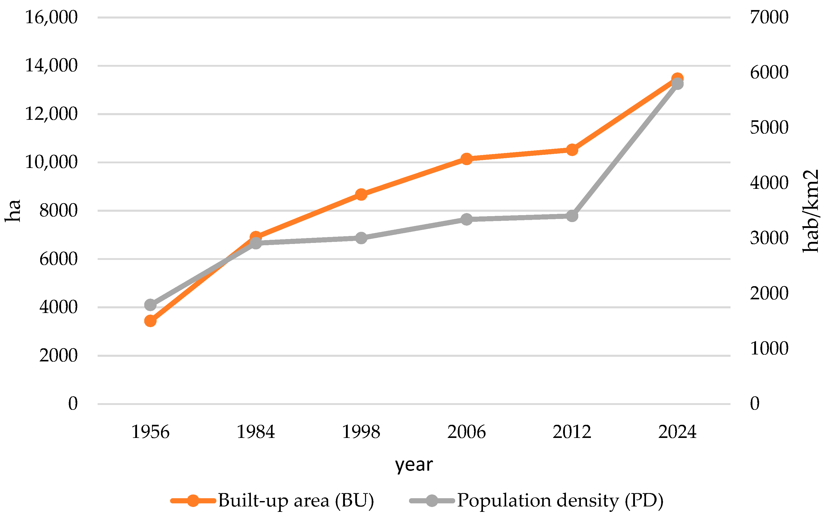
1.3. Urban Expansion and Management

The environmental consequences of urban growth also extend to biodiversity loss and habitat fragmentation. Urban sprawl has overstepped upon natural and semi-natural areas, disrupting ecosystems and threatening species that rely on these habitats. Additionally, soil sealing increases surface temperatures due to reduced vegetation cover and heightened heat absorption by impervious surfaces, contributing to the urban heat island effect. This effect exacerbates the impacts of climate events, particularly in regions like Valencia which are already prone to high temperatures [17].
Policy initiatives, such as the Urban Development Valencian Law of 2005, were introduced to incorporate sustainability into urban planning. However, these measures have faced criticism for insufficient enforcement and limited integration of soil and water resource conservation strategies [18]. The growing demand for urbanization and tourism development in Valencia highlights the need for innovative approaches that harmonize urban expansion with the preservation of natural resources, ensuring resilience against future environmental and climatic challenges [17].

1.4. Forest Fire Impact

Forest fires in Mediterranean regions, particularly Valencia, have become a major environmental concern. These fires have been intensified by land abandonment, meteorological factors, and urban expansion. One significant cause of increased fire intensity is dense vegetation accumulation due to rural land abandonment, acting as fuel for wildfires [19]. Additionally, meteorological factors, such as high temperatures and drought conditions, amplify the susceptibility to fires. Research by Barbera et al. [20] highlighted the role of weather patterns, using the Haines Index to correlate atmospheric stability with fire risk.
Repeated fires degrade ecosystems by depleting soil nutrients and increasing erosion. Studies in La Costera, southern Valencia, showed that repeated burning leads to significant soil erosion and reduced hydrological stability [21]. Urban expansion into Wildland-Urban Interface (WUI) zones further increases fire risks, with studies mapping higher fire probabilities in these areas [22].

1.5. Implementing Nature-Based Solutions in Practice

Local governments must adopt a participatory approach to align ecological restoration efforts with local priorities and contexts. Engaging stakeholders—such as municipalities, community groups, private landowners, and businesses—through workshops, public consultations, and co-creation platforms is essential to build trust and align project goals with community needs. Incorporating traditional ecological knowledge further enhances local capacity to maintain NBS projects post-implementation [23]. For example, involving farmers and landowners in Valencia’s floodplain restoration can ensure practical, community-driven outcomes [15].
NBS policy frameworks should ensure coherence between environmental, urban planning, and socio-economic goals. Aligning NBS initiatives with existing laws on water management and climate adaptation plans enables smoother regulatory approvals and more effective implementation [16]. For instance, Valencia’s dam removal projects demonstrate how local governments can align sustainable water management policies with regional ecological restoration goals [16].
Investments in local capacity-building are critical. Local governments should organize training programs and workshops on hydrological modeling, ecological restoration, and project management. Partnerships with universities and research institutions can provide the expertise needed to design and maintain complex NBS projects.
Financial stability for NBS projects requires diversified investment models. Public–private partnerships, international grants, and community-based crowdfunding should be prioritized. Tax credits or subsidies can encourage sustainable practices such as wetland restoration or reforestation. Additionally, metrics quantifying NBS benefits—like ecosystem service valuation—enhance their attractiveness to investors [16].

2. Materials and Methods

2.1. Materials

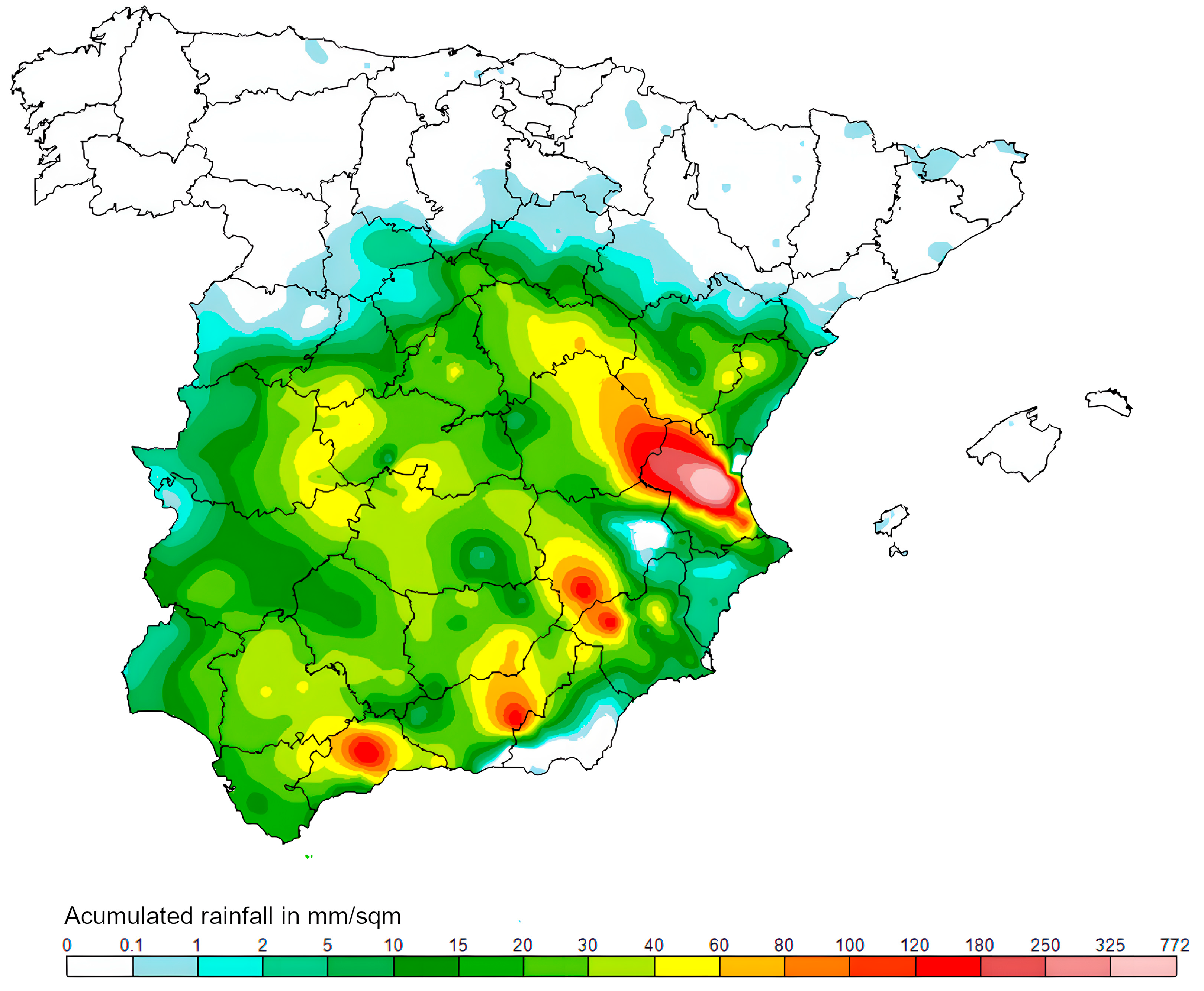
2.1.1. The Severe Rainfall of 29 October 2024

A special advisory issued by the Agencia Estatal de Meteorología (AEMET) on 29 October 2024, outlines the severe weather conditions associated with a Depresión Aislada en Niveles Altos (DANA), which translates to Isolated Depression at High Levels. Stationary near the Gulf of Cádiz, the DANA caused intense and widespread rainfall across Spain, with the highest impact on southern and eastern regions. Rainfall accumulations locally exceeded 150–180 mm within 12–24 h in areas such as the Strait of Gibraltar, Eastern Andalusia, Murcia, and the Valencian Community. Predictions indicate a gradual northwestward movement of the DANA, with continued risks of heavy rainfall, particularly in Western Andalusia, the Iberian system, and Catalonia. AEMET emphasizes close monitoring due to uncertainties in the trajectory and intensity of the system [24].
According to the AEMET, the rainfall recorded on October 29 brought unprecedented levels of precipitation to the province of Valencia. In the region between Utiel and Chiva, rainfall exceeded 300 L per square meter, signaling an extraordinary weather event (Figure 1). Chiva, in particular, experienced an intense deluge, with an astonishing 491 L per square meter falling within just eight hours—an amount nearly equivalent to the typical annual rainfall for the area. This extreme rainfall has underscored the severity of weather patterns affecting the region, contributing to widespread flooding and prompting heightened concerns for flood risk management and climate resilience planning [25].
The flooding in Valencia, Spain, has been documented through satellite imagery, offering a perspective on the disaster’s impact. NASA’s Earth Observatory images show the extent of water accumulation across urban and rural areas, where rainfall has transformed the landscape [26]. The contrast between dry and inundated regions highlights the flooding, which has overwhelmed rivers and submerged large areas. These satellite images are tools for scientists and disaster response teams, providing a view that ground-based observations alone cannot achieve. By documenting flood events, such imagery becomes a dataset for evaluating flood extent, identifying affected areas, and improving future flood prediction and risk management strategies.
The Copernicus Emergency Management Service (CEMS) monitored the flooding in late October 2024, delivering high-resolution satellite imagery to assess the disaster’s scope (Figure 2). Comparative analyses of Sentinel-2 imagery before and after the event illustrate the flood scale and urban impacts, providing a record of the disaster’s effects [27]. Further corroboration came from satellite data collected by the U.S. Landsat-8 and analyzed by the European Space Agency (ESA). Imagery from October 8 and October 30, 2024, showed changes in Valencia’s floodplain, highlighting the widespread consequences of the heavy rainfall [27] (ESA, 2024b).

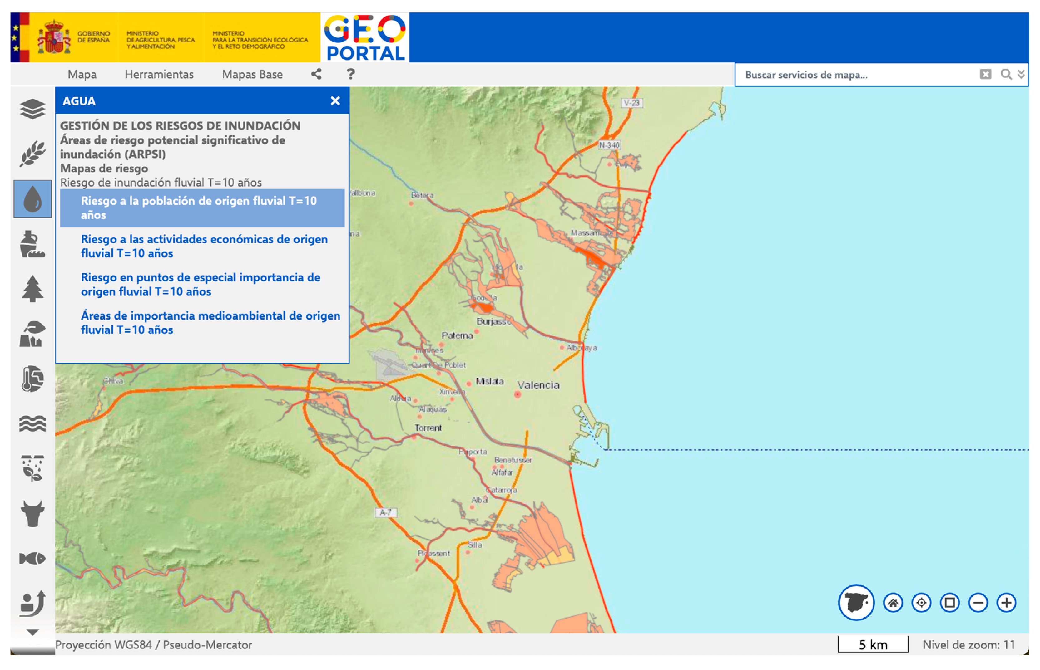
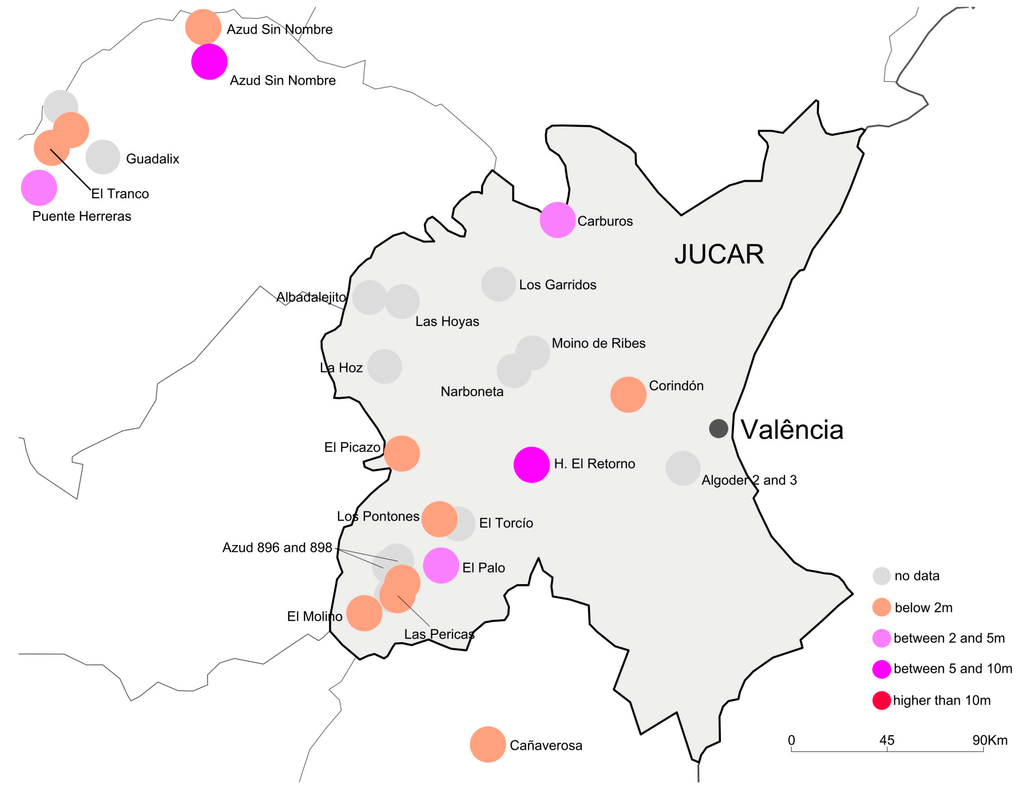
2.1.2. Valencia’s Hydrographic Management

Spain’s dismantling of outdated dams to rehabilitate aquatic ecosystems aligns with the objectives of SDG 6.2 by securing sustainable water resources, reducing flood risks, and enhancing climate resilience (Figure 3). This approach protects water quality and restores natural flow regimes, benefiting communities reliant on these water sources for agriculture, sanitation, and drinking water.
Ministerio para la Transición Ecológica y el Reto Demográfico (MITECO) geoportal assesses flood risks over a 10-year timeframe due to river overflows, highlighting the affected areas with three color-coded levels: yellow, orange, and red zones (Figure 3 and Figure 4).
Figure 3. Flood risk management from river origin in 10-year timeframe [28].
Sustainability 17 04980 g003
Figure 4. Riverine flood risk in Valencia, Spain. Image extracted from Aqueduct Water Risk Atlas [29].
Sustainability 17 04980 g004
The province of Valencia has undertaken the demolition of several weirs and small dams primarily used for irrigation and energy purposes, with removals occurring in 2006, 2015, 2017, and 2022 [30] (Figure 5). Some of these include the Corindón weir, a 1.5-m structure dismantled in 2017 along the Turia River for energy generation, and five weirs on the Rambla de L’Algoder, which were removed in 2006 due to a regulatory sanction. Additionally, the Molí Malanya weir in Bellús was demolished in 2022, although it is not listed on the MITECO geoportal [31]. Beyond Valencia, noteworthy removals include the Carburos weir, a 2-m structure on the Turia River in Teruel dismantled in 2017 for energy generation, and a 7.35-m installation on the Cabriel River near the Albacete border, which was removed in 2015. Furthermore, a small weir near the Contreras Dam on the Cuenca-Valencia border is scheduled for demolition but is not yet listed on the geoportal. Between 2006 and 2021, the Confederación Hidrográfica del Júcar (CHJ), under MITECO, oversaw the removal of additional structures, including the Albaladejito, La Hoz, Las Hoyas, Las Pericas, Los Garridos, and Narboneta dams [30].
These endeavors align with national strategies for ecological restoration, improving river connectivity, enhancing water flow, and complying with regulatory and environmental policies [30].

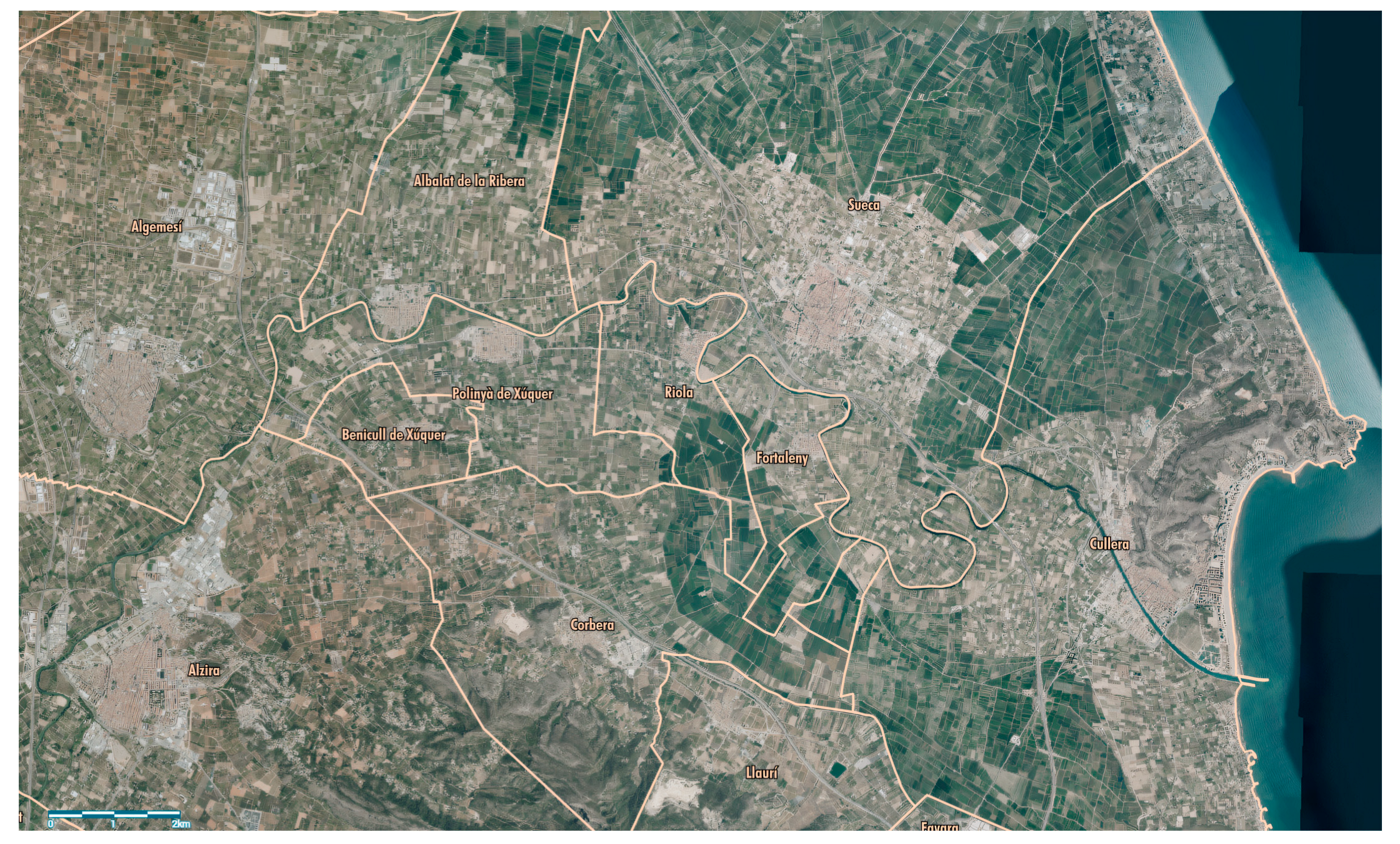
2.1.3. Valencia’s Urban Growth Management

The Valencia region has undergone significant urban expansion over recent decades, profoundly altering land use and posing environmental challenges. Between 1956 and 2012, the metropolitan area of Valencia experienced a 206%increase in urbanized areas, expanding from 3441 hectares to 10,523 hectares [17]. From 2012 to 2024 registered 27.9% reaching 13,465 hectares [32]. (Figure 6). This rapid growth was driven by industrialization, population growth, and increased residential and tourism demands. The process often involved the conversion of highly fertile agricultural land, particularly in historically irrigated areas such as the Horta de Valencia, into sealed urban surfaces, reducing agricultural productivity and increasing land-use conflicts between urban and agricultural sectors [17]. Furthermore, urbanization has intensified environmental degradation, particularly soil degradation, through physical compaction, chemical contamination, and loss of biological activity [33].

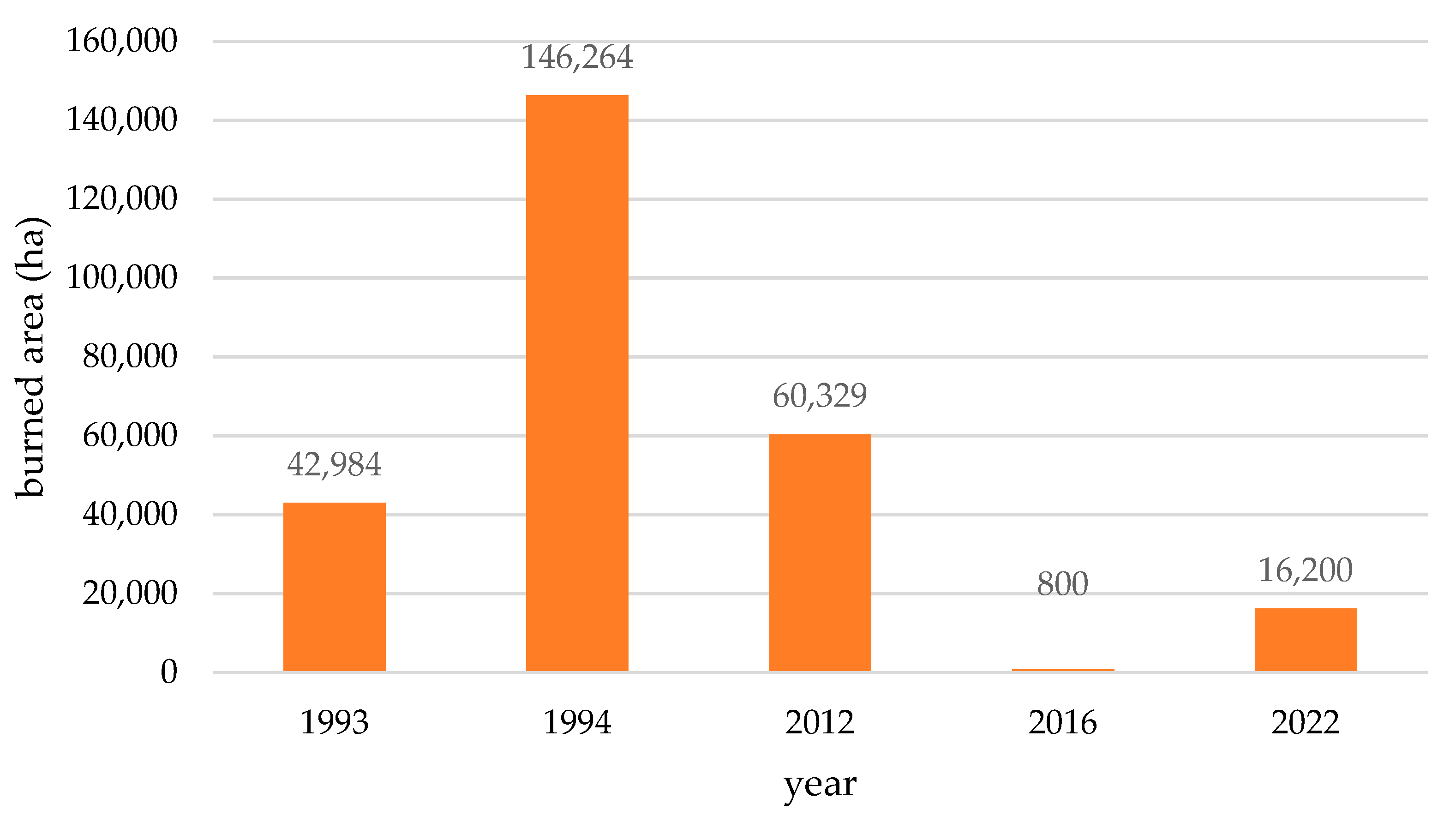
2.1.4. Valencia’s Fire Forest Area

The Generalitat Valenciana provides detailed data on forest fire trends in the region, including annual statistics and analyses of large forest fires [34]. These data indicate that while the overall number of forest fires has fluctuated over the years, there is an observed increase in the frequency of larger and more intense fires. This pattern aligns with broader Mediterranean fire trends, where climate change and land abandonment contribute to heightened fire risks [35].
The section Evolució dels Grans Incendis Forestals (GIF), which translates to Evolution of Large Forest Fires, in Valencia region (Figure 7), Period 1993–2022 specifically details the progression of large-scale fires (those burning over 500 hectares) [34,36,37].
The Valencia region has experienced significant wildfire events over the years, each with notable ecological and hydrological impacts. The following timeline outlines key periods and their associated consequences:
  • Between 1993 and 2015, the Valencian Community experienced 8725 wildfires, which burned approximately 313,020 hectares of land. The year 2005 had the highest number of recorded wildfires (668); however, it was not the year with the most extensive area burned or the greatest number of casualties. The most challenging years for wildfire management were 1993, 1994, and 2012, with burned areas reaching 42,984 hectares, 146,264 hectares, and 60,329 hectares, respectively [37].
  • In 2016, the Bolulla and Tàrbena municipalities in Alicante province were affected by wildfires that consumed around 800 hectares of forested area [34]
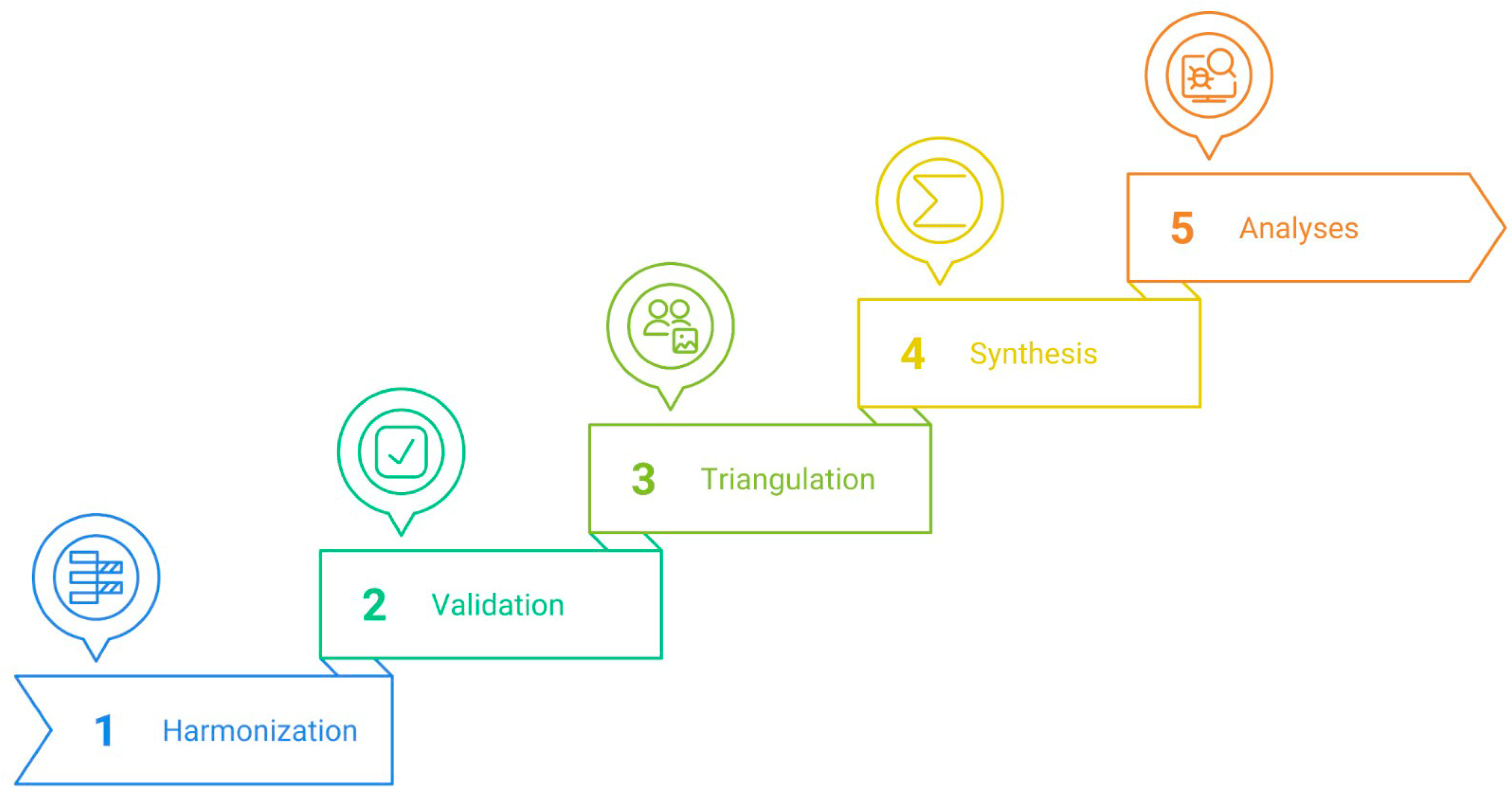
  • Between 2017 and 2023, the Valencian Community experienced significant wildfire activity, with notable incidents including the Vall d’Ebo fire in August 2022, which affected approximately 11,700 hectares, and the Bejís fire during the same period, burning around 4500 hectares [34,36].

2.2. Methods

This study employs a multi-dimensional methodological framework designed to analyze the interplay between climate events, hydrological systems, and anthropogenic factors in Valencia’s flood vulnerability. Our approach integrates quantitative and qualitative data through a systematic five-step process that enables comprehensive assessment of cross-sectoral impacts and identification of spatial vulnerability hotspots:
  • The harmonization process established consistent temporal and spatial parameters across heterogeneous datasets to enable integrated analysis. We acquired and standardized data from multiple sources:
    • Pluviometric intensity records from Agencia Estatal de Meteorología (AEMET);
    • Dam decommissioning datasets from Ministerio para la Transición Ecológica y el Reto Demográfico (MITECO);
    • Urban growth metrics from regional land-use studies;
    • Pyrological datasets from Generalitat Valenciana and European Forest Fire Information System (EFFIS);
This process involved standardizing temporal scales (converting varied time intervals to consistent units), aligning spatial references (standardizing coordinate systems and administrative boundaries), and normalizing measurement units across datasets to enable meaningful comparison.
2.
The validation process ensured data accuracy and reliability through the following systematic verification procedures:
  • Comparative analysis of datasets to identify inconsistencies and anomalies;
  • Iterative flagging and removal of errors and outliers;
  • Cross-verification using official data sources from Spanish government and EU data bodies;
This validation process established a dataset foundation for subsequent analytical steps, particularly important for historical event reconstruction where data varies across the 67-year study period (1957–2024).
3.
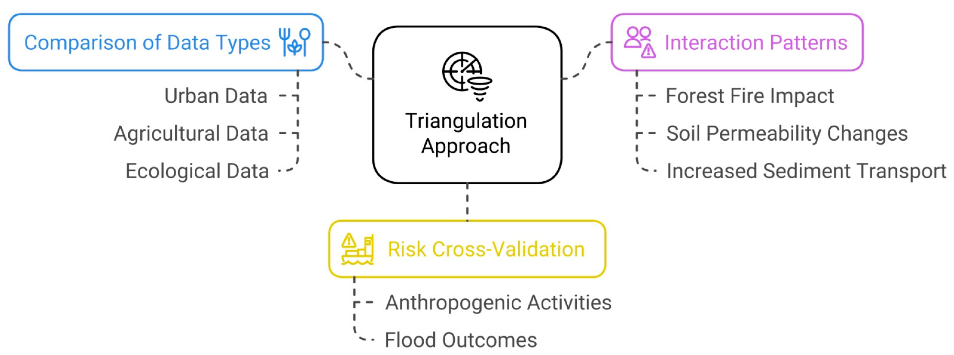
Triangulation approach based on data types enhanced its evaluation in three critical ways:
  • Comparison of data types—started with a comparison between urban, agricultural, and ecological data, on their contribution to flood vulnerabilities in differently built environments;
  • Interaction patterns—proceed with the identification of interaction patterns between external factors—such as how forest fire damage amplifies downstream flood vulnerability through altered soil permeability and increased sediment transport; and,
  • Risk cross-validation—enclosed with the risks cross-validation to identify connections between anthropogenic activities and flood outcomes.
This methodological approach between urbanization patterns, hydrological changes, and flood vulnerability, enables the identification of both direct and indirect causal pathways, Figure 8.
4.
The synthesis phase compiled validated data, which integrates information from diverse scientific studies and official reports:
  • Historical Event Analysis—Each flood event’s characteristics (rainfall, CO2 levels, severity, casualties) were derived from documented historical records from scientific studies [2,3,9,13] and validated newspaper archives such as Reuters [38,39], cross-validated with meteorological and hydrological datasets.
  • CO2 Level Estimation—Atmospheric CO2 levels for each event year were approximated using historical CO2 datasets from climate studies and hydrological models, including those provided by Estrela et al. [40] and [2].
  • Rainfall Data Collection—Precipitation data were sourced from regional meteorological agencies (AEMET [24]) and supplemented with hydrological studies such as those by Llasat et al. [4] to establish accurate precipitation levels during each flood event.
  • Flood Severity Assessment—Flood impacts were evaluated on a standardized scale (1–5: Minor, Moderate, Serious, Severe, Catastrophic) based on documented impacts including displacement, property damage, and fatalities, informed by primary event descriptions and studies such as Schroeder et al. [41].
  • Infrastructure and Environmental Impact—Changes to floodplains, urbanization patterns, and sedimentation were analyzed using land-use studies, dam failure reports, and climate-related research, including those by Valera Lozano et al. [17] and Belmonte and Beltrán [3].
  • Causality and Climate Attribution—The role of anthropogenic climate change was assessed using observational evidence and climate models from sources including the Climate Judiciary Project [42] and the ESA [27].
This synthesis process created a comprehensive dataset that enabled systematic comparison across temporal and spatial dimensions, revealing patterns and trends in flood vulnerability.
5.
The final analytical phase examined the synthesized data through complementary approaches as follows:
  • Hydrological Pattern Analysis—Examination of rainfall and flood event data to identify temporal shifts in hydrological patterns, with particular attention to changing precipitation intensity and frequency;
  • Urban Impact Assessment—Evaluation of urbanization’s role in increasing flood vulnerability through analysis of land-use changes, impervious surface expansion, and altered drainage patterns;
  • Environmental Vulnerability Analysis—Integration of forest fire data, sedimentation reports, and floodplain studies to assess how environmental degradation contributes to flood susceptibility;
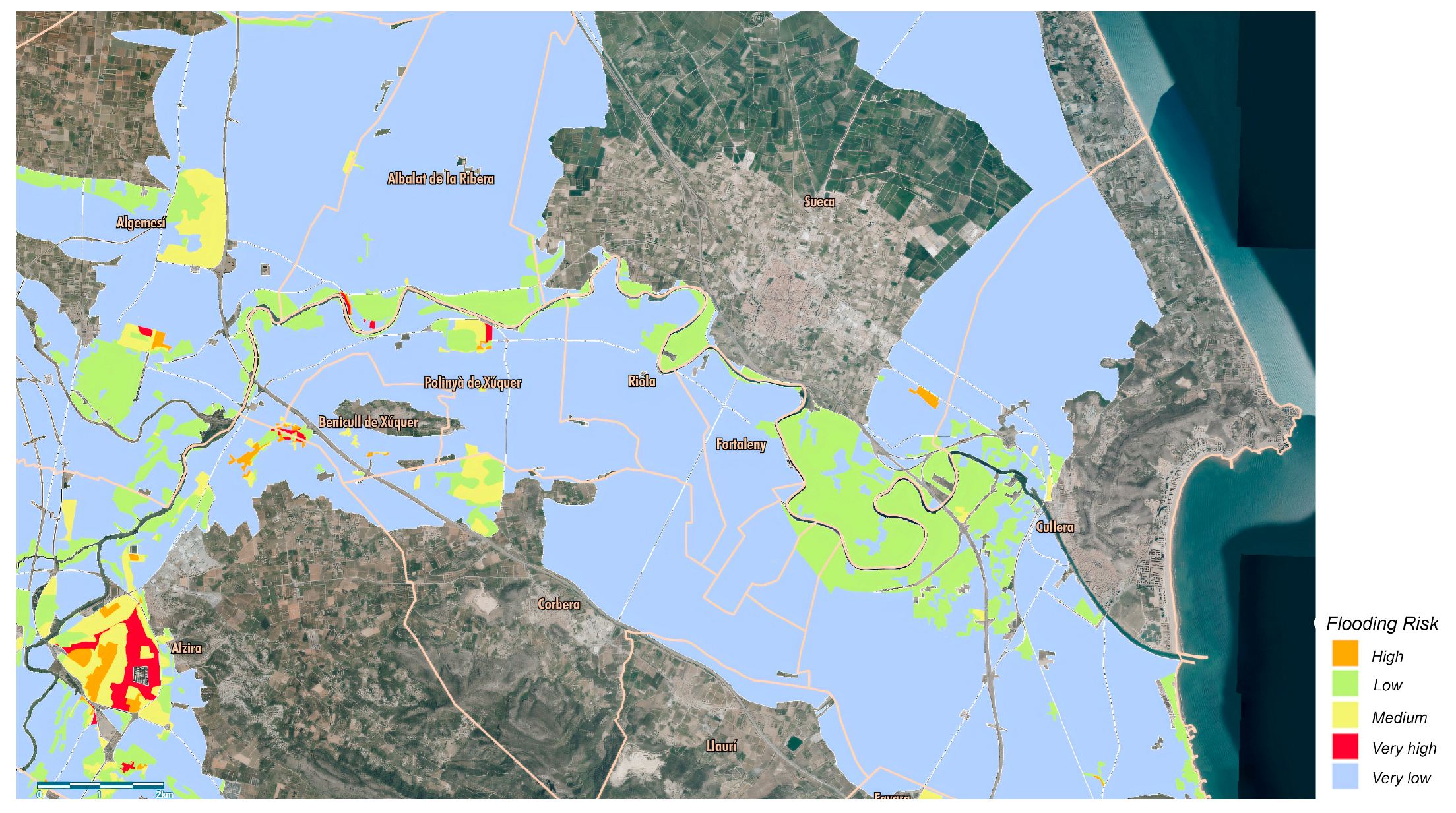
  • Spatial Vulnerability Mapping—Identification of geographic hotspots where multiple risk factors converge, creating areas of heightened vulnerability to flood events.
  • Cascading Impact Modeling—Tracing how primary historical decisions trigger secondary morphological changes and tertiary impact consequences across interconnected systems, from immediate infrastructure damage to long-term ecological and socioeconomic effects.
This multi-dimensional analysis revealed interactions between climate factors, anthropogenic activities, and natural systems that collectively shape Valencia’s vulnerability to flood events, providing the foundation for the adaptive strategies and policy recommendations presented in this study.
This framework aligns with established practices for examining complex systems and their vulnerabilities, incorporating elements of integrated climate risk assessment as observed in studies by Kahlenborn et al. [43] and the Climate Change Committee [44], Figure 9. It is an approach to understanding the dynamics of flood vulnerability in Valencia, integrating datasets across a 67-year timespan to reveal the interplay between climate factors, anthropogenic activities, and natural systems. By systematically progressing through harmonization, validation, triangulation, synthesis, and analysis, our methodology bridges disciplinary boundaries and temporal scales, enabling an assessment that would not be possible through isolated analytical approaches.

3. Results

3.1. The Severe Flooding Events from 2023 to 2024 in the Mediterranean Region

The Mediterranean region has been increasingly vulnerable to extreme weather events, with severe flooding causing significant human and economic losses. In October 2024, Valencia experienced catastrophic flooding, resulting in 229 fatalities [45] and widespread infrastructure damage. Streets were inundated, and high-speed rail services were suspended, prompting the Spanish government to allocate €10 billion for recovery efforts, with a particular focus on climate change adaptation [46]. The following month, Málaga and Barcelona faced severe floods that led to evacuations, transportation disruptions, and infrastructure damage. Portugal’s Algarve region also suffered localized flooding, necessitating emergency responses [47,48].
A comparative analysis of major flood events in the Mediterranean highlights the scale of these disasters. Valencia experienced extreme precipitation of 491 mm within just 8 h, leading to the highest casualties and economic losses among the analyzed events [38,49]. In contrast, Málaga recorded 114 mm of rainfall over 24 h, causing €3.5 billion in damages and one fatality [27,50,51]. Other Mediterranean cities, such as Athens and Derna, also faced extreme precipitation, with Athens recording 700–800 mm in 24 h [52] and Derna experiencing 400 mm in the same period [53], both resulting in substantial infrastructure damage. Table 1 illustrates how Valencia’s catastrophic floods rank among the most severe in terms of immediate impacts, casualties, and recovery needs, highlighting the increasing vulnerability of Mediterranean regions to extreme weather events and the importance of coordinated response strategies.

3.2. The Severe Flooding Events from 1957 to 2024 in the Valencian Region

Flooding in the Valencian region has intensified over the decades due to a combination of natural variability, urban expansion, forest fires, and the growing impacts of CO2 in the atmosphere. Significant events, from the 1957 Turia River flood to the catastrophic 2024 floods, highlight evolving vulnerabilities in infrastructure, land management, and disaster preparedness.
Table 2 provides a comprehensive synthesized comparison of five significant flood events in the Valencia region—1957, 1982, 2000, 2007, and 2024—focusing on key metrics such as CO2 levels, rainfall intensity, flood severity, and related environmental and infrastructural factors:
  • Atmospheric CO2 concentrations have risen from approximately 315 ppm in 1957 to 420 ppm in 2024, reflecting the broader trend of anthropogenic climate change [2,40]. These rising CO2 levels align with increased global temperatures, contributing to a more moisture-laden atmosphere and potentially more intense rainfall events [72].
  • Rainfall data demonstrates increasingly intense precipitation over time, with the 1982 Tous Dam flood recording over 500 mm in 24 h and the 2024 event recording 491 mm in just 8 h [72]. This trend suggests a shift toward shorter, more intense rainfall events linked to warmer atmospheric conditions.
  • Flood severity is measured on a scale of 1 to 5, with the 1982 Tous Dam failure and the 2024 floods both rated as catastrophic (severity 5). Both events underscore the importance of infrastructure preparedness in mitigating flood impacts [13].
  • Urbanization and dam removals have reduced natural drainage and water regulation capacity, compounding the effects of extreme rainfall. The 2024 floods were further exacerbated by sedimentation due to upstream erosion, a consequence of recurrent forest fires [3,17].
  • While natural variability influenced earlier events like the 1957 flood, later events show an increasing role of anthropogenic changes, particularly in amplifying rainfall intensity [27,42].
  • Over the decades, flood events in Valencia have resulted in significant casualties, including 81 fatalities during the 1957 flood, 8 fatalities and 100,000 evacuations from the 1982 Tous Dam collapse, and 217 fatalities in the 2024 Valencia flood, highlighting the escalating human impact of such disasters over time.
These events underscore the compounding effects of urbanization, forest fires, riverbed exploitation, and dam removals, which have reduced natural floodplain capacities and increased sedimentation from upstream erosion [3,17].

3.3. Urban Expansion and the Flood Risks in the Valencian Region

Urban expansion in Valencia from 1956 to 2024 transformed the landscape, with urbanized space increasing from 9.3% to approximately 30% by 2012 [17], and impermeable surfaces expanding by 391% (10,024 hectares) over the entire period [1]. This growth sealed about 5763 hectares of high-capability agricultural soils, with 71.4% occurring on fertile fluvisols in floodplains by 2012 [17]. This shift from productive agricultural land to urban development has exacerbated surface runoff, amplified flood risks, reduced groundwater recharge, and disrupted natural water regulation systems. The impermeabilization of soils has further strained water resources, creating challenges for agricultural productivity and ecosystem resilience [17]. While green infrastructure, such as permeable pavements and restored green spaces, helps mitigate these effects, unchecked sediment exploitation remains a critical issue, particularly in coastal areas under pressure from urban and tourist development.
Resorting Geographic Information Systems (GIS) [73], we extracted thematic maps to visually correlate 2024’s urban area with the hydrologically sensitive areas, including flood-prone zones, as Figure 10 and Figure 11, both Coord. UTM (ETRS89, Huso30) from the Institut Cartogràfic Valencià.
These spatial representations distinctly illustrate that urban areas predominantly encroached upon identified floodplains, intensifying hydrological vulnerabilities. Impermeabilization of these areas reduced natural soil infiltration capacities, thereby increasing surface runoff volumes and accelerating water flow velocity during heavy precipitation events. Concurrently, the loss of permeable agricultural land diminished groundwater recharge and disrupted natural sediment transport mechanisms, contributing to geomorphological instability and heightened downstream flood risks.
The maps demonstrate how urban-induced growth amplifies the hydrological vulnerabilities, underscoring the importance of sustainable urban planning strategies to mitigate flooding under several events.

4. Discussion

The interplay of historical, climatic, and anthropogenic factors has shaped the hydrological and environmental challenges faced by the Valencia region, particularly in light of increasing extreme weather events. This section synthesizes the implications of the findings, situating them within the broader context of global climate adaptation strategies and urban resilience planning.
Frequent and intense floods in Valencia are often attributed to climate change, but this view oversimplifies the interplay between natural hydrological systems and human interventions. Historical records, such as the 1957 flood, show that catastrophic flooding has long been a feature of Valencia’s Mediterranean climate, driven by episodic torrential rains and steep, sparsely vegetated terrain [27,42]. Focusing solely on weather patterns overlooks the significant impact of human activities in reshaping water systems to accommodate urban expansion.
The region’s extensive river channelization, dam construction, and urbanization of floodplains have disrupted natural hydrological dynamics, reducing water absorption and increasing flood risks. The redirection of the Turia River, for instance, prioritized economic and urban development over long-term environmental resilience [74]. Similarly, the 1982 Tous Dam failure was primarily due to engineering flaws and inadequate emergency planning rather than climatic factors [13]. Urban sprawl and soil sealing have further exacerbated flood impacts by limiting natural drainage [17].
Overemphasizing climate change diverts attention from the broader issue: harmonizing human activity with natural systems. While climate change intensifies extreme weather, the root causes of Valencia’s flood vulnerability lie in historical planning decisions that prioritize short-term gains over sustainable water management [1]. Due to urban growth and surface the sealing of high-capability agricultural soils further strained hydrological systems. While green infrastructure, such as permeable pavements and restored green spaces, helps mitigate these effects, unchecked sediment exploitation remains a critical issue, particularly in coastal areas under pressure from urban and tourist development [17].
Extensive sediment extraction has altered riverbed geomorphology, reducing roughness and accelerating water velocity during heavy rains, increasing downstream flood risks and erosion [75]. Disrupting natural sediment transport also weakens floodplain fertility and destabilizes ephemeral streams (ramblas), making them more prone to flash floods [3]. Over time, sediment depletion diminishes the river’s ability to buffer against surges, intensifying flood impacts.
Mitigating these risks requires stricter sediment extraction regulations and efforts to restore natural sediment dynamics. A balanced approach is needed, addressing both climate trends and human-induced risks. NBS such as replenishing degraded riverbeds and reducing soil sealing through urban planning can enhance river stability. A possible way to go is integrating these measures with advanced hydrological models would improve predictive assessments of long-term sediment exploitation impacts .
Limited awareness and resistance to change, particularly in agricultural communities, hinder the acceptance of NBS [38]. A lack of public engagement during planning exacerbates mistrust, reducing local support [76]. Strengthening stakeholder involvement through participatory planning, consultations, and capacity-building initiatives—such as workshops and the integration of traditional ecological knowledge (TEK)—can improve acceptance and disaster resilience [77,78]. Incentives like tax credits and pilot projects further encourage participation, while adaptive monitoring ensures strategies remain effective and aligned with SDG 6 and SDG 13 [79].
Fragmented governance, a lack of integrated policies, and a preference for short-term infrastructure projects over long-term resilience hinder NBS implementation [18]. Addressing these challenges requires transparent communication of NBS benefits—such as enhanced flood resilience, biodiversity gains, and economic advantages—to build trust among policymakers and communities. Co-creation approaches and participatory planning help align NBS with local needs, minimizing conflicts over land use [6]. Policy updates integrating green infrastructure and incentives, like tax credits, can further promote adoption [6]. Demonstrating success through pilot projects reduces political resistance and encourages wider acceptance [80].
NBS high upfront costs and inadequate valuation of ecosystem services limit private sector investment, while bureaucratic delays complicate funding access [81]. However, NBS generates long-term economic benefits by attracting investments, reducing flood damage costs, and creating jobs in ecological restoration, construction, and maintenance [82]. Community-driven initiatives strengthen local economies, and opportunities like eco-tourism within restored floodplains support sustainable development [83]. Aligning NBS with regional economic objectives fosters financial resilience while promoting public–private collaboration and financial incentives can support widespread adoption [84,85].
The restoration of riverine ecosystems through dam removal and floodplain rehabilitation has demonstrated significant ecological and socio-economic benefits across diverse geographical contexts. Several case studies in the Mediterranean area highlight the effective application of NBS in addressing environmental challenges, particularly in the face of increasing climate extreme patterns in highly dense populated areas. Such as:
  • Ebro Delta Restoration Project (Spain): Faced with rising sea levels and sediment loss, the Ebro Delta project utilized NBS-like wetland restoration and sediment management to combat coastal erosion and flooding. Community involvement played a critical role in monitoring and maintaining restored areas, while EU funding ensured the sustainability of the initiative [86].
  • Floodplain Restoration in the Po River Basin (Italy): To address recurrent flooding, this project restored natural floodplains and reconnected rivers to their surrounding ecosystems. Local farmers and landowners were actively engaged through compensation schemes and collaborative planning processes, ensuring the project’s acceptance [87].
  • Ecosystem-Based Adaptation in the Nile Basin (Egypt): In response to water scarcity and climate variability, Egypt implemented ecosystem-based approaches, such as wetland conservation and afforestation, to stabilize water systems. International funding from climate adaptation programs supported these efforts, demonstrating the scalability of NBS [88].
  • Blue–Green Infrastructure in Thessaloniki (Greece): Thessaloniki integrated green corridors and permeable surfaces into its urban fabric to improve stormwater management and mitigate urban heat islands. Local stakeholder workshops ensured the adaptation of designs to community needs, while European cohesion funds provided financial backing [35].
Collectively, these projects underscore the dual benefits of flood risk reduction—achieved through naturalized flow regimes and sediment dynamics—and ecosystem recovery, including wetland regeneration and species resurgence. Successful outcomes, however, hinge on context-specific strategies that address local hydrological, ecological, and socio-economic conditions, emphasizing adaptive planning to optimize trade-offs between human infrastructure and environmental integrity [88].
Forest fires are a major environmental challenge in the Mediterranean, including Valencia, where land-use changes, rural abandonment, and climatic factors have increased fire frequency and intensity [19]. Poor land management and inadequate prevention strategies further amplify these risks.
Fires disrupt regional hydrology by removing vegetation, reducing water retention, and increasing surface runoff, which heightens flood risks [21]. Post-fire soil erosion contributes to sedimentation in rivers, clogging drainage systems, and reducing reservoir capacity, worsening flood impacts [3]. Historically, agricultural and grazing activities helped control biomass accumulation, but rural depopulation has led to unchecked vegetation growth, increasing fire hazards [32].
Current fire management focuses on suppression rather than prevention, leading to fuel build-up that results in more severe fires—known as the “fire paradox” [20]. Frequent burning depletes soil fertility, disrupts water cycles, and accelerates desertification, threatening ecological resilience and water security [21].
A proactive approach is needed, integrating fire prevention, land management, and post-fire restoration:
  • Use controlled burns and sustainable grazing to limit flammable biomass.
  • Implement reforestation and soil stabilization to reduce sedimentation and restore hydrological balance [22].
  • Promote policies that encourage active land management and reduce fuel accumulation [19].
  • Utilize satellite imaging and hydrological models to predict fire-related flood risks and improve response strategies [6].
While rising temperatures and prolonged droughts contribute to fire risks, attributing the problem solely to climate change overlooks deeper systemic issues. Unsustainable land use, inadequate fire prevention, and neglect of rural landscapes are the primary drivers of worsening fire conditions. Addressing these challenges requires a shift from reactive suppression to proactive management, ensuring policies target the underlying causes rather than just responding to the consequences.
These challenges are reflected in Figure 7, particularly from 2014 to 2023, highlighting the increasing pressures on forest ecosystems due to both climatic and anthropogenic factors.
Valencia’s alignment with SDG 6.2 reflects a commitment to global sustainability goals. However, global frameworks like the UN SDGs often assume that large-scale environmental transformations can occur uniformly across diverse regions. This top-down approach overlooks local socio-economic constraints, infrastructural limitations, and the complexities of regional hydrological systems [18].
While the 2030 Agenda for Sustainable Development promotes rapid policy shifts, implementing large-scale initiatives—such as dam decommissioning, river restoration, or land-use changes—requires substantial financial, technical, and cultural resources that many local governments, including Valencia, struggle to mobilize [8]. For instance, removing smaller dams to meet SDG 6.2’s targets has disrupted agriculture and water access for local farmers, often without delivering immediate ecological benefits [12,15]. This disconnection highlights the tension between global objectives and local needs.
The pursuit of the One-Size-Fits-All Approach has limitations and collaterals. SDGs prioritize quantifiable benchmarks, such as hectares of reforestation or infrastructure removal, to measure progress [15]. However, these metrics often favor short-term visibility over long-term effectiveness. The push for reforestation and land-use changes has frequently excluded local farmers and landowners, disregarding their traditional knowledge and economic reliance on the land. Sustainable development requires community-driven initiatives rather than externally imposed solutions.
Furthermore, socioeconomic barriers to change are often underestimated. Valencia’s experience demonstrates that transitioning to sustainable practices can impose financial burdens on vulnerable groups, such as smallholder farmers and rural landowners. Without proper support or alternative livelihoods, these populations bear the costs of ambitious policies while struggling to adapt [17].
A more effective approach requires flexibility, community engagement, and incremental adaptation:
  • Policies should consider regional environmental, cultural, and economic factors, rather than applying global standards uniformly [13].
  • Rather than demanding immediate transformation, gradual adaptation allows communities time to adjust, especially in high-risk areas.
  • Community organizations and local governments must be empowered with financial and technical support to ensure effective, inclusive decision-making.
  • Hydrological assessments and adaptive management strategies should inform policy decisions, recognizing that sustainability is an evolving process rather than a fixed goal [6].
We concluded that it is necessary to rethink global sustainability approaches, as the success of sustainability policies depends not on their ambition but on their alignment with local realities. Global frameworks must evolve from rigid mandates to adaptive, region-specific models that balance environmental goals with economic and social sustainability. Sustainable development should be measured not by the speed of implementation but by the depth of impact—ensuring that policies foster resilience, trust, and lasting change. The complex interplay of river dynamics, geographic shifts, soil sealing, forest fires, sediment exploitation, and erosion must be approached with caution due to the countless variables influencing their severity. As climate patterns intensify in highly dense populated areas, there is an urgent need for scalable models capable of simulating and mitigating adverse scenarios effectively.
While our methodology provides a robust framework for analyzing Valencia’s flood vulnerability, several constraints and limitations should be acknowledged. Regarding data validation, we primarily relied on datasets that had already undergone revised treatment and publication by key official authorities that regularly monitor these phenomena, including AEMET, MITECO, and the Generalitat Valenciana. These datasets (1957–2024) are widely accepted by the scientific community as valid and ready for research applications, which allowed us to focus our efforts on integration rather than primary validation. Where multiple sources provided identical or similar data, we conducted cross-source comparisons to ensure accuracy and consistency, selecting sources with wider temporal coverage and spatial resolution when discrepancies arose. For instance, when comparing urban growth metrics, we prioritized Valera Lozano et al. [17] data (1956–2012) over alternative sources due to its comprehensive temporal range and methodological consistency. This approach, while efficient, inherently accepts the validation standards of the original data providers and may incorporate any limitations present in those datasets. Additionally, the heterogeneity of data collection methods across the 67-year study period introduces potential inconsistencies, particularly for older records where documentation of collection methodologies may be less detailed. Despite these constraints, future research would benefit from more granular validation of historical records, particularly those predating standardized digital archiving practices.

5. Conclusions

The Valencia region illustrates the complexities of managing hydrological systems amid rapid urbanization, ecological degradation, extreme climate patterns, increasingly extreme weather events, and the pressure to implement regulatory frameworks such as the UN-SDGs. The key findings from this study can be summarized as follows:
  • Complex Interplay of Climate and Human Activities: While climate change is an undeniable driver of increased flood risks, attributing all hydrological challenges solely to it oversimplifies the issue. Human activities, including urban expansion, river sediment exploitation, and inadequate maintenance of infrastructure, have played a significant role in intensifying these risks. Addressing these challenges requires a balance between mitigating climate change impacts and rectifying historical human interventions.
  • Urbanization and Soil Sealing: The rapid urbanization of Valencia has significantly increased impermeable surfaces, increasing surface runoff and reducing the natural capacity for water absorption. Policies promoting green infrastructure, such as permeable pavements and urban green spaces, are essential to counteract these impacts. However, their implementation must consider the socio-economic and cultural dynamics of local communities.
  • NBS and Their Limitations: NBS, such as floodplain restoration and dam removal, offer benefits in enhancing biodiversity and ecological resilience. However, these strategies are not without challenges, including increased river flow speeds and downstream sedimentation. Hybrid approaches that integrate ecological and engineered solutions are critical to achieving sustainable outcomes.
  • The Role of Forest Fires: Forest fires have significantly altered the hydrology and sediment dynamics of the region, contributing to increased runoff and erosion. These impacts are compounded by land abandonment and inadequate fire management practices. Effective solutions must include proactive vegetation management, erosion control, and hydrological monitoring.
  • Global Frameworks vs. Local Realities: The implementation of global policies, such as the UN-SDGs, often prioritizes rapid and transformative changes. However, these frameworks can overlook the specific socio-economic and ecological realities of regions like Valencia. A gradual, community-driven approach is essential to ensure the sustainability and acceptance of these policies.
  • Community Engagement as a Cornerstone: Meaningful progress in hydrological and environmental management requires the active participation of local stakeholders. Integrating traditional knowledge and empowering local communities can bridge the gap between global aspirations and practical implementation.
The lessons from Valencia highlight the importance of context-specific, adaptive strategies in addressing the dual challenges of climate extreme patterns and unsustainable human practices. Sustainable progress depends on harmonizing global frameworks with local realities, ensuring that interventions are not only ecologically sound but also socially and economically feasible.
This research bridges historical, ecological, and urban perspectives to propose adaptive strategies for mitigating hydrological challenges in Valencia. By emphasizing the integration of nature-based solutions, community engagement, and context-specific policies, the paper provides a replicable framework for addressing climate-related vulnerabilities in similar regions worldwide.

Author Contributions

Conceptualization, N.D.C. and C.C.D.; methodology, N.D.C. and C.C.D.; validation, N.D.C. and C.C.D.; formal analysis, N.D.C. and C.C.D.; investigation, N.D.C.; resources, N.D.C. and C.C.D.; data curation, N.D.C.; writing—original draft preparation, N.D.C.; writing—review and editing, C.C.D.; visualization, C.C.D.; supervision, N.D.C.; project administration, N.D.C.; funding acquisition, C.C.D. All authors have read and agreed to the published version of the manuscript.

Funding

This work is financed by national funds through FCT—Fundação para a Ciência e a Tecnologia, I.P., under the Strategic Project with the references UIDB/04008/2020 and UIDP/04008/2020.

Institutional Review Board Statement

Not applicable.

Informed Consent Statement

Not applicable.

Data Availability Statement

The data are available on request from the authors.

Acknowledgments

The authors acknowledge the support and contribution of CIAUD, the Research Center in Architecture, Urbanism, and Design.

Conflicts of Interest

The authors declare no conflicts of interest.

Abbreviations

The following abbreviations are used in this manuscript:
AEMETAgencia Estatal de Meteorología (State Meteorological Agency, Spain)
CEMSCopernicus Emergency Management Service
CJPClimate Judiciary Project
CHJConfederación Hidrográfica del Júcar (Júcar River Basin Confederation)
DANADepresión Aislada en Niveles Altos (Isolated Depression at High Levels)
EFFISEuropean Forest Fire Information System
ESAEuropean Space Agency
GIFGrans Incendis Forestals (Large Forest Fires)
MITECOMinisterio para la Transición Ecológica y el Reto Demográfico (Ministry for Ecological Transition and Demographic Challenge, Spain)
NBSNature-Based Solutions
SDGSustainable Development Goals
UNUnited Nations
WUIWildland-Urban Interface

References

  1. ESA Valencia Flood Disaster. Available online: https://www.esa.int/ESA_Multimedia/Images/2024/10/Valencia_flood_disaster (accessed on 29 January 2025).
  2. Gómez-Martínez, G.; Galiano, L.; Rubio, T.; Prado-López, C.; Redolat, D.; Paradinas Blázquez, C.; Gaitán, E.; Pedro-Monzonís, M.; Ferriz-Sánchez, S.; Añó Soto, M.; et al. Effects of Climate Change on Water Quality in the Jucar River Basin (Spain). Water 2021, 13, 2424. [Google Scholar] [CrossRef]
  3. Camarasa Belmonte, A.M.; Segura Beltrán, F. Flood events in Mediterranean ephemeral streams (ramblas) in Valencia region, Spain. CATENA 2001, 45, 229–249. [Google Scholar] [CrossRef]
  4. Llasat, M.-C.; Barriendos, M.; Barrera, A.; Rigo, T. Floods in Catalonia (NE Spain) since the 14th century. Climatological and meteorological aspects from historical documentary sources and old instrumental records. J. Hydrol. 2005, 313, 32–47. [Google Scholar] [CrossRef]
  5. Vallve, M.B.; Martin-Vide, J. Secular Climatic Oscillations as Indicated by Catastrophic Floods in the Spanish Mediterranean Coastal Area (14th–19th Centuries). Clim. Change 1998, 38, 473–491. [Google Scholar] [CrossRef]
  6. Mason, D.C.; Davenport, I.J.; Neal, J.C.; Schumann, G.J.-P.; Bates, P.D. Near Real-Time Flood Detection in Urban and Rural Areas Using High-Resolution Synthetic Aperture Radar Images. IEEE Trans. Geosci. Remote Sens. 2012, 50, 3041–3052. [Google Scholar] [CrossRef]
  7. Tanim, A.H.; McRae, C.B.; Tavakol-Davani, H.; Goharian, E. Flood Detection in Urban Areas Using Satellite Imagery and Machine Learning. Water 2022, 14, 1140. [Google Scholar] [CrossRef]
  8. EC River Basin Management in a Changing Climate. Available online: https://environment.ec.europa.eu/publications/river-basin-management-changing-climate_en (accessed on 29 January 2025).
  9. Faus Prieto, A. La riada del Turia de 1731. Una aproximación a la literatura de la catástrofe. Investig. Geográficas 2015, 64, 129–143. [Google Scholar] [CrossRef]
  10. Camprubí, L. Engineers and the Making of the Francoist Regime; The MIT Press: Cambridge, MA, USA, 2014; ISBN 978-0-262-32322-2. [Google Scholar]
  11. Rubio-Martin, A.; Pulido-Velazquez, M.; Macian-Sorribes, H.; Garcia-Prats, A. System Dynamics Modeling for Supporting Drought-Oriented Management of the Jucar River System, Spain. Water 2020, 12, 1407. [Google Scholar] [CrossRef]
  12. González del Tánago, M.; García de Jalón, D.; Román, M. River Restoration in Spain: Theoretical and Practical Approach in the Context of the European Water Framework Directive. Environ. Manag. 2012, 50, 123–139. [Google Scholar] [CrossRef]
  13. Schoolmeesters, R. Tous Dam (Spain, 1982)|Case Study|ASDSO Lessons Learned. Available online: https://damfailures.org/case-study/tous-dam-spain-1982/ (accessed on 29 January 2025).
  14. Batalla, R.J. Sediment deficit in rivers caused by dams and instream gravel mining. A review with examples from NE Spain. Cuaternario Geomorfol. Rev. Soc. Esp. Geomorfol. Asoc. Esp. Para El Estud. Cuaternario 2003, 17, 79–91, ISSN 0214-1744. [Google Scholar]
  15. UN Transforming Our World: The 2030 Agenda for Sustainable Development|Department of Economic and Social Affairs. Available online: https://sdgs.un.org/publications/transforming-our-world-2030-agenda-sustainable-development-17981 (accessed on 29 January 2025).
  16. MITECO. Strategic Orientations on Water and Climate Change; MITECO: Madrid, Spain, 2022. [Google Scholar]
  17. Valera, A.; Vidal, C.; Sánchez, J. Urban growth (1956-2012) and soil sealing in the metropolitan area of Valencia (Eastern Spain). Span. J. Soil Sci. 2019, 9, 88–104. [Google Scholar] [CrossRef]
  18. Miralles i García, J. The Introduction of the Sustainability in the Procedures Regulated for Urban Planning: The Case of the Last Act on Urbanism, Territory and Landscape in the Valencian Community (Spain); WIT Press: Billerica, MA, USA, 2007; p. 513. ISBN 978-1-84564-069-9. [Google Scholar]
  19. López-Poma, R.; Orr, B.J.; Bautista, S. Successional stage after land abandonment modulates fire severity and post-fire recovery in a Mediterranean mountain landscape. Int. J. Wildland Fire 2014, 23, 1005–1015. [Google Scholar] [CrossRef]
  20. Barberà, M.J.; Niclòs, R.; Estrela, M.J.; Valiente, J.A. Climatology of the stability and humidity terms in the Haines Index to improve the estimate of forest fire risk in the Western Mediterranean Basin (Valencia region, Spain). Int. J. Climatol. 2015, 35, 1212–1223. [Google Scholar] [CrossRef]
  21. Cerda, A.; Imeson, A.C.; Calvo, A. Fire and aspect induced differences on the erodibility and hydrology of soils at La Costera, Valencia, southeast Spain. CATENA 1995, 24, 289–304. [Google Scholar] [CrossRef]
  22. Fernández-Manso, A.; Quintano, C.; Fernández-Guisuraga, J.M.; Roberts, D. Next-gen regional fire risk mapping: Integrating hyperspectral imagery and National Forest Inventory data to identify hot-spot wildland-urban interfaces. Sci. Total Environ. 2024, 940, 173568. [Google Scholar] [CrossRef]
  23. EPC The Assessment of the Effects of Certain Public and Private Projects on the Environment. Available online: https://eur-lex.europa.eu/eli/dir/2014/52/oj/eng (accessed on 27 January 2025).
  24. AEMET. Informe Sobre el Episodio Meteorológico de Precipitaciones Torrenciales y Persistentes Ocasionadas por una DANA el día 29 de Octubre de 2024; AEMET: Madrid, Spain, 2024. [Google Scholar]
  25. Pucik, T. Meteorological Analysis of Extreme Flash Flood Situation in the Valencia Region; European Severe Storms Laboratory: Weßling, Germany, 2024. [Google Scholar]
  26. NASA. Valencia Floods. Available online: https://earthobservatory.nasa.gov/images/153533/valencia-floods (accessed on 29 January 2025).
  27. ESA Devastating Floods in Spain Witnessed by Satellites. Available online: https://www.esa.int/Applications/Observing_the_Earth/Devastating_floods_in_Spain_witnessed_by_satellites (accessed on 29 January 2025).
  28. MITECO. Seguimiento e Implantación de la Estrategia Nacional de Restauración de Ríos. Available online: https://www.miteco.gob.es/es/agua/temas/delimitacion-y-restauracion-del-dominio-publico-hidraulico/estrategia-nacional-restauracion-rios/seguimiento-e-implantacion.html (accessed on 29 January 2025).
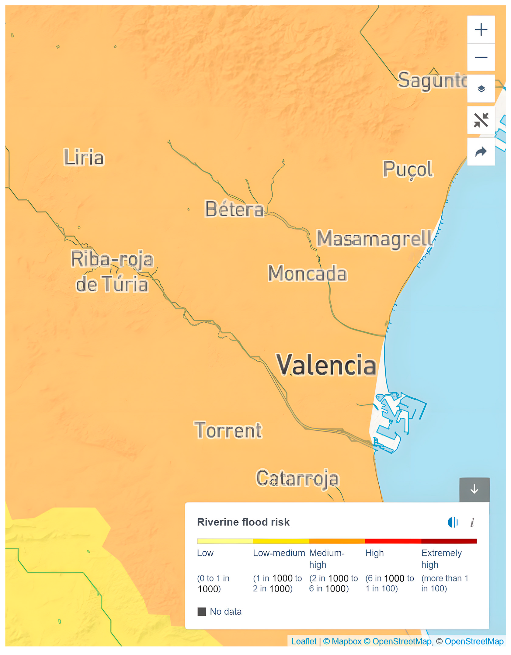
  29. World Resources Institute Aqueduct Water Risk Atlas. Available online: https://www.wri.org/applications/aqueduct/water-risk-atlas/#/?advanced=false&basemap=hydro&indicator=rfr_cat&lat=39.45899296747316&lng=-0.37010192871093756&mapMode=view&month=1&opacity=0.5&ponderation=DEF&predefined=false&projection=absolute&scenario=optimistic&scope=baseline&timeScale=annual&year=baseline&zoom=12 (accessed on 29 January 2025).
  30. Maldita Disinformation Narratives Blaming Imaginary “Dam and Reservoir Demolitions” of the Consequences of the Floods in Valencia·Maldita.es-Periodismo Para que no te la Cuelen. Available online: https://maldita.es/clima/20241104/dams-reservoirs-removed-floods-valencia/ (accessed on 29 January 2025).
  31. MITECO. Geoportal. Available online: https://sig.mapama.gob.es/geoportal/ (accessed on 29 January 2025).
  32. World Population Review Valencia, Spain Population 2024. Available online: https://worldpopulationreview.com/cities/spain/valencia?utm_source (accessed on 30 January 2025).
  33. Simon, E.; Bin, I.H.; Sipos, B.; Abriha-Molnár, V.É.; Abriha, D.; Andreu-Sanchez, O.; Boluda, R.; Roca-Pérez, L. Effect of urbanisation on soil and plant pollution in province of Valencia, Spain). bioRxiv 2024, 2024.03.27.586674. [Google Scholar] [CrossRef]
  34. Generalitat Valenciana Estadística d’incendis Forestals-Prevención de Incendios Forestales y Sensibilización. Available online: https://mediambient.gva.es/va/web/prevencion-de-incendios/estadistica-de-incendios-forestales (accessed on 29 January 2025).
  35. Kirkland, M.; Atkinson, P.W.; Aliácar, S.; Saavedra, D.; De Jong, M.C.; Dowling, T.P.F.; Ashton-Butt, A. Protected areas, drought, and grazing regimes influence fire occurrence in a fire-prone Mediterranean region. Fire Ecol. 2024, 20, 88. [Google Scholar] [CrossRef]
  36. Copernicus European Forest Fire Information System. Available online: https://forest-fire.emergency.copernicus.eu/ (accessed on 29 January 2025).
  37. Zambon, I.; Cerdà, A.; Cudlin, P.; Serra, P.; Pili, S.; Salvati, L. Road Network and the Spatial Distribution of Wildfires in the Valencian Community (1993–2015). Agriculture 2019, 9, 100. [Google Scholar] [CrossRef]
  38. Aguado, J. Economic Impact of Floods in Spain Could Rise to over 10 Bln Euros; Reuters: London, UK, 2024. [Google Scholar]
  39. Khalip, A.; Landauro, I. What Caused Deadly Floods in Spain? The Impact of DANA Explained; Reuters: London, UK, 2024. [Google Scholar]
  40. Estrela, T.; Pérez-Martin, M.A.; Vargas, E. Impacts of climate change on water resources in Spain. Hydrol. Sci. J. 2012, 57, 1154–1167. [Google Scholar] [CrossRef]
  41. Schroeder, A.J.; Gourley, J.J.; Hardy, J.; Henderson, J.J.; Parhi, P.; Rahmani, V.; Reed, K.A.; Schumacher, R.S.; Smith, B.K.; Taraldsen, M.J. The development of a flash flood severity index. J. Hydrol. 2016, 541, 523–532. [Google Scholar] [CrossRef]
  42. CJP. Drawing the Causal Chain: The Detection and Attribution of Climate Change. Available online: https://cjp.eli.org/curriculum/drawing-causal-chain-detection-and-attribution-climate-change (accessed on 29 January 2025).
  43. Kahlenborn, W.; Voss, M.; Porst, L.; Zebisch, M.; Renner, K.; Schauser, I. Integrated risk analyses as part of national climate risk assessments: Lessons learnt from the climate risk assessment of Germany. Int. J. Clim. Change Strateg. Manag. 2025; ahead-of-print. [Google Scholar] [CrossRef]
  44. Climate Change Committee. UK Climate Change Risk Assessment 2017 Evidence Report; Climate Change Comittee: London, UK, 2017; p. 23. Available online: https://www.theccc.org.uk/wp-content/uploads/2016/07/UK-CCRA-2017-Launch-slidepack.pdf (accessed on 29 January 2025).
  45. Actualización de datos del Gobierno de España. Available online: https://www.lamoncloa.gob.es/info-dana/paginas/2024/191124-datos-seguimiento-actuaciones-gobierno.aspx (accessed on 4 March 2025).
  46. El País ‘Tragedy of Absolutely Incredible Dimensions’: Death Toll Continues to Rise After Flash Flooding in Spain. Available online: https://english.elpais.com/spain/2024-10-30/at-least-51-killed-in-flooding-in-spain.html (accessed on 29 January 2025).
  47. EWN Algarve Hit by Flash Floods due to DANA. Available online: https://euroweeklynews.com/2024/11/15/algarve-portugal-hit-by-flash-floods-due-to-dana-5-minute-rainfall/ (accessed on 29 January 2025).
  48. Associated Press New Storms and Flooding Threaten Spain’s Hard-Hit Valencia Again. Available online: https://apnews.com/article/spain-floods-malaga-79ec155360f14a0b89a788e8cb6787b4 (accessed on 29 January 2025).
  49. WMO. Devastating Rainfall Hits Spain in Yet Another Flood-Related Disaster. Available online: https://wmo.int/media/news/devastating-rainfall-hits-spain-yet-another-flood-related-disaster (accessed on 29 January 2025).
  50. Tanno, S.; Paddison, L.; Brown, B.; Mosquera, P. 20241030-Spain-Rainfall. Available online: https://ix.cnn.io/dailygraphics/graphics/20241030-spain-rainfall/index.html?initialWidth=910&childId=graphic-20241030-spain-rainfall&parentTitle=Spain%20hit%20by%20deadliest%20floods%20in%20decades.%20Here%E2%80%99s%20what%20we%20know%20%7C%20CNN&parentUrl=https%3A%2F%2Fedition.cnn.com%2F2024%2F10%2F31%2Feurope%2Fspain-deadly-flash-flooding-wwk-intl%2Findex.html (accessed on 29 January 2025).
  51. Borrego, J.B. Outdated regulations and institutional vulnerability: Hydrological risk management in Málaga’s municipal planning. Heliyon 2023, 9, e18691. [Google Scholar] [CrossRef]
  52. Sioutas, M.; Lekidis, V.; Kokolakis, C. Flooding Phenomena in the Metropolitan Area of Thessaloniki: Anthropogenic and Climate Change Effects. In Proceedings of the SafeAttica 2023; SafeGreece: Athens, Greece, 26 December 2023. 2023, pp. 133–136, EgyptToday Alexandria has Witnessed Heavy Torrential Rains, Floods Since 2015: Governor. Available online: https://www.egypttoday.com/Article/1/109552/Alexandria-has-witnessed-heavy-torrential-rains-floods-since-2015-Governor (accessed on 29 January 2025).
  53. País, E. Storms in Spain Head for Western Andalusia after Lashing Málaga and Valencia. Available online: https://english.elpais.com/climate/2024-11-14/storms-in-spain-head-for-western-andalusia-after-lashing-malaga-and-valencia.html (accessed on 30 January 2025).
  54. Cima Research Foundation Greece Floods: Data, Forecasts, and Scientific Analysis of the Event. BBC News Libya Floods: Why Damage to Derna was so Catastrophic. 2023. Available online: https://www.cimafoundation.org/en/news/greece-floods-data-forecasts-and-scientific-analysis-of-the-event/ (accessed on 30 January 2025).
  55. Orellana, J.S. El Ayuntamiento de Málaga Cancela o Pospone los actos Organizados por los Distritos con Motivo de Halloween. Available online: https://cadenaser.com/andalucia/2024/10/31/el-ayuntamiento-de-malaga-cancela-o-pospone-los-actos-organizados-por-los-distritos-con-motivo-de-halloween-ser-malaga/ (accessed on 30 January 2025).
  56. MedCyclones. Mediterranean Cyclone Daniel, 3–11 September 2023; MedCyclones, 2023; p. 3, Contreras, V. Una Inundación Como Cuatro Veces la Ciudad de València; Available online: https://www.levante-emv.com/comunitat-valenciana/2024/11/12/dana-valencia-la-zona-inundada-supera-cuatro-veces-el-termino-de-valencia-cartografia-111605143.html (accessed on 30 January 2025).
  57. He, K.; Yang, Q.; Shen, X.; Dimitriou, E.; Mentzafou, A.; Papadaki, C.; Stoumboudi, M.; Anagnostou, E. Brief communication: Storm Daniel flood impact in Greece in 2023: Mapping crop and livestock exposure from synthetic-aperture radar (SAR). Nat. Hazards Earth Syst. Sci. 2024, 24, 2375–2382. [Google Scholar] [CrossRef]
  58. Le Monde with AFP Libya Floods: Inhabitants of Derna Ask for Accountability. Le Monde 2023. Paris, France. La Vanguardia Normalcy Will Take Time to Reach Spain’s Flooded Areas. Available online: https://www.lavanguardia.com/mediterranean/20241105/10080597/normality-time-cold-drop-valencia-massanassa-catarroja-army-epicenter-rainfall-mud-street-flood.html (accessed on 30 January 2025).
  59. Bostyn, Y. These Are the Malaga Towns Most at Risk From Flooding During Red-Level Rain Storms; Olive Press News Spain: Málaga, Spain, 2024. [Google Scholar]
  60. Libya-Impact of Storm Daniel: An Update on Displacement and Needs (November 2023)-Libya|ReliefWeb. Available online: https://reliefweb.int/report/libya/libya-impact-storm-daniel-update-displacement-and-needs-november-2023 (accessed on 30 January 2025).
  61. Euronews. At least Four People Die after Severe Floods Hit Greece. Available online: https://www.euronews.com/2023/09/07/at-least-four-people-die-after-severe-floods-hit-greece (accessed on 30 January 2025).
  62. The Globe and Mail Death Toll Soars to 11,300 in Flooding in Libya’s Coastal City of Derna, Libyan Red Crescent Says. Available online: https://www.theglobeandmail.com/world/article-libya-flood-casualties-could-have-been-avoided-with-warning-system/ (accessed on 30 January 2025).
  63. Cabezas, E. Malaga Villages Slowly Return to Normal One Month on from the Floods. Available online: https://www.surinenglish.com/malaga/axarquia/benamargosa-and-comares-recover-one-month-after-20241216080215-nt.html (accessed on 30 January 2025).
  64. Orellana, J.S. Álora (Málaga), Tres Meses Después de la Catástrofe que Provocó la DANA: “El Gobierno Central no nos ha Dado ni un Céntimo”. Available online: https://cadenaser.com/andalucia/2025/01/29/alora-malaga-tres-meses-despues-de-la-catastrofe-que-provoco-la-dana-el-gobierno-central-no-nos-ha-dado-ni-un-centimo-ser-malaga/ (accessed on 30 January 2025).
  65. Death Toll Rises in Greece as Flooding Devastates Thessaly Region. Available online: https://www.wsws.org/en/articles/2023/09/14/asmd-s14.html (accessed on 30 January 2025).
  66. ReliefWeb Libya Hurricane Daniel: Situation Report 2-27/09/2023-Libya. Available online: https://reliefweb.int/report/libya/libya-hurricane-daniel-situation-report-2-27092023 (accessed on 30 January 2025).
  67. AP News Spain’s Catastrophic Floods by the Numbers: At Least 219 Dead, 93 Missing and Billions in Damage. Available online: https://apnews.com/article/spain-floods-valencia-numbers-21fccd4a9eba4fada0745db0a5a0dd12 (accessed on 30 January 2025).
  68. NASA Science Evidence 2022. Available online: https://science.nasa.gov/climate-change/evidence/ (accessed on 29 January 2025).
  69. Visor Cartogràfic de la Generalitat. Available online: https://visor.gva.es/visor/?extension=266363,4115432,1161436,4619187&nivelZoom=8&capasids=Orto_Actual;,Ordenacion_Territorial;12,Ordenacion_Territorial;11,Ordenacion_Territorial;10,Ordenacion_Territorial;9,Ordenacion_Territorial;8,Ordenacion_Territorial;7,Ordenacion_Territorial;6,Ordenacion_Territorial;5,Ordenacion_Territorial;4,Ordenacion_Territorial;3,Ordenacion_Territorial;1&tcapas=1.0,1.0,1.0,1.0,1.0,1.0,1.0,1.0,1.0,1.0,1.0,1.0&idioma=es (accessed on 31 March 2025).
  70. Lehoczky, A.; Sobrino, J.A.; Skoković, D.; Aguilar, E. The Urban Heat Island Effect in the City of Valencia: A Case Study for Hot Summer Days. Urban Sci. 2017, 1, 9. [Google Scholar] [CrossRef]
  71. Portugués, I.; Bonache, X.; Mateu, J.F.; Marco, J.; Bonache i Felici, X. A GIS-Based Model for the analysis of an urban flash flood and its hydro-geomorphic response. The Valencia event of 1957. J. Hydrol. 2016, 541, 582–596. [Google Scholar] [CrossRef]
  72. Karagianni, M. Making Thessaloniki Resilient? The Enclosing Process of the Urban Green Commons. Urban Plan. 2023, 8, 346–360. [Google Scholar] [CrossRef]
  73. Sinthumule, N.I.; Mudau, N.V. Participatory approach to flood disaster management in Thohoyandou. Jàmbá J. Disaster Risk Stud. 2019, 11, 1–7. [Google Scholar] [CrossRef]
  74. Meyer, M.; Hendricks, M.D.; Newman, G.D.; Horney, J.; Berke, P.; Masterson, J.; Sansom, G.; Cousins, T.; Zandt, S.V.; Cooper, J. Participatory Action Research: Tools for Disaster Resilience Education. Int. J. Disaster Resil. Built Environ. 2018, 9, 402–419. [Google Scholar] [CrossRef]
  75. Khaspuria, G.; Ranjan, A.; Sahil; Soni, P.; Dadhich, K. Natural Disaster Mitigation Strategies: A Comprehensive Review. J. Sci. Res. Rep. 2024. [Google Scholar] [CrossRef]
  76. Duffaut, C.; Frascaria-Lacoste, N.; Versini, P. Barriers and Levers for the Implantation of Sustainable Nature-Based Solutions in Cities: Insights from France. Sustainability 2022, 14, 9975. [Google Scholar] [CrossRef]
  77. Lupp, G.; Huang, J.; Zingraff-Hamed, A.; Oen, A.M.P.; Sepia, N.D.; Martinelli, A.; Lucchesi, M.; Knutsen, T.W.; Olsen, M.; Fjøsne, T.; et al. Stakeholder Perceptions of Nature-Based Solutions and Their Collaborative Co-Design and Implementation Processes in Rural Mountain Areas—A Case Study From PHUSICOS. Front. Environ. Sci. 2021, 9, 12. [Google Scholar] [CrossRef]
  78. Solheim, A.; Capobianco, V.; Oen, A.M.P.; Kalsnes, B.; Wullf-Knutsen, T.; Olsén, M.; Seppia, N.D.; Arauzo, I.; Balaguer, E.G.; Strout, J. Implementing Nature-Based Solutions in Rural Landscapes: Barriers Experienced in the PHUSICOS Project. Sustainability 2021, 13, 1461. [Google Scholar] [CrossRef]
  79. EPC Framework for Community Action in the Field of Water Policy. Available online: https://eur-lex.europa.eu/eli/dir/2000/60/2014-11-20/eng (accessed on 27 January 2025).
  80. Maes, J.; Jacobs, S. Nature-Based Solutions for Europe’s Sustainable Development. Conserv. Lett. 2017, 10, 121–124. [Google Scholar] [CrossRef]
  81. Biasin, A.; Masiero, M.; Amato, G.; Pettenella, D. Nature-Based Solutions Modeling and Cost-Benefit Analysis to Face Climate Change Risks in an Urban Area: The Case of Turin (Italy). Land 2023, 12, 280. [Google Scholar] [CrossRef]
  82. Toxopeus, H.S.; Polzin, F. Reviewing financing barriers and strategies for urban nature-based solutions. J. Environ. Manag. 2021, 289, 112371. [Google Scholar] [CrossRef]
  83. Andrikopoulou, T.; Schielen, R.; Spray, C.; Schipper, C.; Blom, A. A Framework to Evaluate the SDG Contribution of Fluvial Nature-Based Solutions. Sustainability 2021, 13, 11320. [Google Scholar] [CrossRef]
  84. Sopena Porta, M.P.; Pellicer, F. Urban Planning and Landscape Projects on Urban Riverbanks in Europe: Comparative Study of the Ebro River, Zaragoza, and the Isar River, Munich. Urban Sci. 2024, 8, 152. [Google Scholar] [CrossRef]
  85. Frascaroli, F.; Parrinello, G.; Root-Bernstein, M. Linking contemporary river restoration to economics, technology, politics, and society: Perspectives from a historical case study of the Po River Basin, Italy. Ambio 2021, 50, 492–504. [Google Scholar] [CrossRef]
  86. Al-Saidi, M.; Elagib, N.A.; Ribbe, L.; Schellenberg, T.; Roach, E.; Oezhan, D. Water-Energy-Food Security Nexus in the Eastern Nile Basin. In Water-Energy-Food Nexus; American Geophysical Union (AGU): Washington, DC, USA, 2017; pp. 103–116. ISBN 978-1-119-24317-5. [Google Scholar]
  87. Kastanidou, S.; Katsavounidou, G. Urban streams as focal points of urban regeneration: The area of Konstantinidis stream in Toumba, Thessaloniki. E3S Web Conf. 2024, 585, 09001. [Google Scholar] [CrossRef]
  88. Jing, L.; Zeng, Q.; He, K.; Liu, P.; Fan, R.; Lu, W.; Lei, G.; Lu, C.; Wen, L. Vegetation Dynamic in a Large Floodplain Wetland: The Effects of Hydroclimatic Regime. Remote Sens. 2023, 15, 2614. [Google Scholar] [CrossRef]
Figure 1. Accumulated rainfall in mm per sqm on 29 October 2024, to 6 pm. Adapted by the authors from Sky News sourced by AEMET [24].
Sustainability 17 04980 g001
Figure 2. Satellite image before (a) and after (b) the 29 October (accessed on 19 December 2024, CEMS).
Sustainability 17 04980 g002
Figure 5. Obsolete weirs and small dams demolished (2000–2021) marked by height. Adapted by the authors from MALDITA.ES [30], sourced by MITECO.
Sustainability 17 04980 g005
Figure 6. Urban growth in the Valencia region over time (1956–2012). Adapted from the Valera Lozano et al. [17] up to 2012 and World Population Review [32] data.
Sustainability 17 04980 g006
Figure 7. Burned Hectares during wildfires in Valencia region [34,36,37].
Sustainability 17 04980 g007
Figure 8. Triangulation diagram.
Sustainability 17 04980 g008
Figure 9. Methodological framework.
Sustainability 17 04980 g009
Figure 10. Orthophoto map of Valencia Region, Spain highlighting the Municipalities [73].
Sustainability 17 04980 g010
Figure 11. Orthophoto map of Valencia Region, Spain highlighting the flooding risk—legend follows the Institut Cartogràfic Valencià webpage [73].
Sustainability 17 04980 g011
Table 1. Flooding Mediterranean events from 2023 to 2024.
Valencia, Spain (2024) Málaga, Spain (2024)Athens, Greece (2023)Derna, Lybia (2023)
Precipitation (mm)491 mm in 8 h [52]114 mm in 24 h [54]700–800 mm in 24 h [55]400 mm in 24 h [56]
Duration (Hours/Days)2 Days [52]2 Day [57]8 Days [58]3 Days [56]
Affected Area (km2)562.7 km2 [59]-1150 km2 [60]6 km2 (highly dense urban area) [61]
Population Affected+800,000 [62]206,971 [63]225,000 [55]44,862 [64]
Casualties229 [39]1 [63]4 [65]11.300 [66]
Infrastructure Damagedresidential areas, industrial, commercial, public services, and public infrastructures [37,43,46,49,52]residential areas, agricultural areas, public infrastructures [54,57,63,67,68]residential areas, agricultural areas, public infrastructures [55,58,60,65,69]residential areas, public infrastructures (two dams damaged) [56,61,64,66,70]
Economic Impact (€)+ €10 billion [71]€3.5 billion [67,68] €2.25 billion [69]€18.3 billion (from 19 billion USD) [70]
Table 2. Flooding Valencian events from 1957 to 2024.
Metric1957 Event1982 Event (Tous Dam)2000 Event2007 Event2024 Event
CO2 Levels (ppm)~315~340~370~380~420
Maximum Rainfall (mm)~200–300 in 24 h>500 in 24 h~400 in 24 h~200 in a few hours~491 in 8 h; ~300+ in 24 h
Flood Severity (1–5)Severe (4)Catastrophic (5)Severe (4)Severe (4)Catastrophic (5)
Temperature ImpactMinimal anthropogenic contributionSlight warming (~0.5 °C above pre-industrial)Moderate warming (~0.7 °C above pre-industrial)Moderate warming (~0.8 °C above pre-industrial)Significant warming (+1.2 °C above pre-industrial)
Floodplain ConditionsLimited infrastructure for flood protectionFloodplain overwhelmed by Tous Dam collapseUrban expansion exacerbated flood impactsUrban floodplain vulnerabilitiesUrbanized areas with reduced natural drainage
SedimentationModerateDownstream sedimentation from dam collapseMinimalMinimalExacerbated by forest fires and erosion
Dam RegulationUnregulated Turia River; limited infrastructureTous Dam failure with peak inflows > 9912 m3/sManaged but inadequate for extreme rainfallAdequate but tested by torrential rainReduced dam numbers due to removal
Flood ImpactsInundated central Valencia, river rechanneledCatastrophic collapse, 100,000 evacuatedSevere urban floodingSevere but localizedWidespread urban and rural impacts, fatalities
Climate AttributionPrimarily natural variabilityPartially natural, minor anthropogenic factorsIncreasing anthropogenic contributionIncreasing anthropogenic contributionAnthropogenic climate change contribution
Number of Casualties81800229
Disclaimer/Publisher’s Note: The statements, opinions and data contained in all publications are solely those of the individual author(s) and contributor(s) and not of MDPI and/or the editor(s). MDPI and/or the editor(s) disclaim responsibility for any injury to people or property resulting from any ideas, methods, instructions or products referred to in the content.

