Article

Urban Form and Sustainable Neighborhood Regeneration—A Multiscale Study of Daegu, South Korea

by
Emilien Gohaud
,
Amarpreet Singh Arora
and
Thorsten Schuetze
*
Department of Architecture, College of Engineering, Sungkyunkwan University, Suwon 16419, Republic of Korea
*
Author to whom correspondence should be addressed.
Sustainability 2025, 17(11), 4888; https://doi.org/10.3390/su17114888
Submission received: 3 April 2025 / Revised: 8 May 2025 / Accepted: 19 May 2025 / Published: 26 May 2025
(This article belongs to the Special Issue Urban Planning and Sustainable Land Use—2nd Edition)

Abstract

:
Notwithstanding the Korean Urban Regeneration Act 2013’s support for sustainable neighborhood regeneration programs, the number and scale of such projects relative to large-scale urban redevelopment remain limited. To address this imbalance, this research advances existing form-based approaches through a multi-scalar morphological analysis encouraging harmonized urban transformation and sustainable urban regeneration. The analysis encompasses the macroscale (metropolitan area development), mesoscale (urban characterization of the central urban area), and microscale (aging urban fabric detailed analysis). The case study focuses on Daegu, a major Korean city experiencing population decline. Mappings and quantitative and qualitative analysis used Geographic Information System QGIS, as well as the Python suite Momepy. The study revealed that large-scale urban redevelopments are driving urban densification and demographic shifts. While older low-rise structures occupy most of the urban landscape in the central city area, piecemeal high-rise redevelopment is increasingly fragmenting it. The overly fine urban grain resists regeneration, limiting car access, building scales, and urban density. The research findings help identify the urban areas that are most appropriate for urban regeneration and redevelopment projects and streamline and coordinate planning efforts and the adjusting of regulations. The method developed is transferable to other Korean and international cities, fostering sustainable urban regeneration.

1. Introduction

1.1. The Korean Urban Boom

Following the Korean War (1950–1953), South Korea (hereafter Korea) experienced rapid economic growth, by the 21st century transforming into one of the world’s most advanced economies. However, the rapid urbanization has led to significant societal and spatial imbalances [1,2]. In the six decades from 1950 to 2010, the urban population nationwide grew ten-fold to reach 40.6 million people or 81.9% of the total population [3]. From 1950 to the time of writing, the country’s GDP has surged 478-fold, and land prices have soared 680-fold [4]. With 524 inhabitants per km2 in 2022 [5] and large stretches of undeveloped mountainous area, Korea is one of the world’s most densely populated countries. Traditionally rural, the country was technically and culturally unprepared for the acute urban concentration that accompanied modernity. In the 1970s, the government initiated extensive collective housing developments that were based on modernist planning principles [6]. Large high-rise apartment complexes (Korean: apateu danji) became progressively omnipresent, transforming cityscapes and lifestyles. Apartment complexes became both a tool and a symbol of Korea’s newfound prosperity [7]. Korean urbanization, with Seoul as its main metropolis, is still rapidly evolving, driven by a developmental state that tends to answer every urban issue with further, larger projects. In the highly concentrated Korean economy, mass production and rampant speculation have commodified land and housing [8,9].

1.2. Premature Urban Decline

Urban decline in Korea followed the shift in economic structure. Initial industrialization spurred rural-to-urban migration, depopulating the countryside and small- to mid-scale cities. Early light industry then yielded to low-labor-cost countries, spreading the decline to early industrial cities, such as Daegu, while the economic structure evolved toward heavy industry, advanced technology, and services [10,11]. Korea now undergoes a concentration of population toward the global metropolis of Seoul, while the rest of the country experiences decline. Supplementary Materials Figure S1 provides a statistical overview of Korea’s transformation.
At the city scale, areas prosper or decline following conditions such as accessibility, environment quality, and opportunities for employment and education. Additionally, a finer, more localized decay is evident throughout Korean cities, where deprived old areas closely adjoin newer, thriving ones [10]. This localized urban decline and decay is a side effect of Korea’s urban development practices. Denser new developments supersede older neighborhoods, creating a push toward obsolescence [12]. Poor construction standards further accelerate decay, with buildings constructed before 2000 requiring major renovations within 25 years [13]. Old neighborhoods commonly present signs of decay and abandonment as owners and authorities await potential wholesale redevelopment, rather than conducting ongoing maintenance and gradual improvement [10].
As the era of high growth has ended and the country faces population decline, the unsustainability of such a situation has become more acute. In 2022, the country’s fertility rate at 0.87 was the lowest in the world, and by 2100, the population is expected to halve [5]. Redevelopment cannot be the sole answer to urban maintenance, nor can it address the socio-economic struggles of all citizens. With rising awareness of the cultural and historical value of the low-rise ‘old city’, the notion of urban regeneration entered the Korean debate in the late 1990s [14].

1.3. Korean Neighborhood Regeneration

Contemporary urban regeneration can be defined as a holistic policy that is targeted at the durable improvement of run-down or deprived urban areas (Appendix A proposes a glossary of specific terms related to urbanism). As opposed to earlier wholesale reconstruction practices, it concurrently addresses social, economic, and physical environment issues [15,16,17]. Based on Couch et al. [18], urban regeneration can be assigned to two broad categories: (i) urban renaissance, aimed at consolidating the city’s urban core and preserving its attractiveness in a competitive liberal society, and (ii) neighborhood regeneration, aimed at improving the physical, economic and social life condition of residents.
In the late 1990s, Korea began implementing early neighborhood regeneration projects under the concept of ‘village making’ (Korean: maeulmandeulgi). This concept is inspired by the Japanese idea of neighborhood or ‘community making’ (Japanese: machizukuri), which emphasizes active resident participation and local community development [19,20]. After the introduction of Urban Vitality Promotion Area Projects in 2009, the 2013 Special Act on Revitalization and Support for Urban Regeneration created the framework for holistic urban regeneration projects. In 2017, the Moon government further intensified the policy by launching the Urban Regeneration New Deal program [21,22]. From 2017 to 2021, the equivalent of EUR 6.9 billion was allocated yearly, with the goal of initiating a hundred new regeneration projects each year. Amongst the 311 projects initiated as of 2019, 73% fell in the category of neighborhood regeneration, with target area ranging from 5 to 20 hectares [23]. Despite some success [24], policies for urban regeneration in Korea were generally deemed inefficient, particularly with regard to the amounts invested. The impact of area-based projects was often limited and short-lived [21,22,23]. Cases such as Daegu ‘miro maeul’ can be observed where, at the end of an urban regeneration project, neighborhoods underwent wholesale redevelopment [25]. Since 2022, the new Yoon government has operated a reorientation and reduction in urban regeneration funds [26].

1.4. Urban Form and Regeneration

Amongst the challenges faced by Korean urban regeneration programs, scholars have noted the difficult competition with highly profitable wholesale redevelopment and urban code and zoning unsuitable for the ‘old’ city, as well as difficulty in bringing about significant improvement to the physical environment [14,22,27]. Urban redevelopment and regeneration policies must take a unified approach to urban management [28]. Conventional urban zoning and redevelopment practices constitute the main barrier to successful neighborhood regeneration, in large part, as they do not acknowledge the characteristic urban form of each neighborhood nor the way these neighborhoods interact. Following concepts outlined in previous studies [29,30,31], the authors of this research propose a form-based neighborhood regeneration urban planning and policy approach in Korea. Urban codes, zoning, the planning of redevelopments, and area-based urban regeneration projects must be guided by precise knowledge of the existing urban fabric characteristics.
In Western countries, the development of urban morphology, starting in the 1960s, was part of the renewal of city planning and design theory. Traditional approaches included the historical geography school of M.R.G. Conzen in England and the typological process school of Saverio Muratori in Italy, later combined in the French typo-morphological approach [32,33]. Those theories fostered a positive reassessment of historical urban fabric and supported new designs and planning that were coherent with the pre-existing urban environment. We can cite as examples the ‘critical reconstruction’ and ‘careful urban renewal’ in the framework of the 1987 Berlin IBA [34,35]. In France, the so-called ‘return to the city’ was concretized in the Paris 1977 urban code (POS). The POS acknowledged streets, blocks, and plots as the base elements of the city. Established tissues were recognized for urban renovation and custom-made neighborhood codes [36,37,38]. By the 1990s, urban morphology had established itself as an international field of study [33], with its scope and applications gradually broadening over time [39,40]. From the 2000s, townscape management and form-based urban planning and coding were developing concepts linking urban form analysis and planning [41,42,43,44]. Urban morphology has recently evolved toward integrating traditional analytical approaches with advanced computational methods—including space syntax, morphometrics, and GIS. This synthesis allows for better understanding and prescription in rapidly changing urban environments [45,46].
Korea employs a functional zoning system, which focuses on the juxtaposition of functional units regardless of their integration into a formally coherent whole. Conversely, the form-based approach discussed here uses urban morphology to recognize existing urban form and foster continuity and harmony in the urban landscape (this general term must be distinguished from the more specific case of New Urbanism’s ‘form-based code’). In a seminal article, John Habraken emphasized the connection between urban form and regeneration as early as 1964, presenting the regeneration of the urban tissue itself as an imperative [47]. By 2016, researchers in Glasgow had developed the link between urban form and urban regeneration [48,49], based on the notion of plot-based urbanism [50]. In 2021, a team of researchers proposed a framework to grasp the dynamics of urban evolution and provide operative tools for regeneration under the notion of Transitional Morphology [51]. The present paper fits within this research perspective.

1.5. Asian and Korean Urban Morphology

Urban morphology developed in Europe with the historical city as its main object of study. The field of research needed to be extended to new urban spaces, such as the modern city [52], as well as to new regions, such as Asia and its new metropolises [53]. Studies such as that of Pingyao [54] or Nanjing [55] demonstrated the adaptability of traditional urban morphology to the Asian context but still targeted historical cities with a preservation-focused approach. The morphological atlas of Wuhan used a larger multiscale approach supported by GIS to characterize all urban tissues equally [56].
Korean urban form studies also showed a bias toward historical settlements, with mainly descriptive research [57]. Such study can be found for the traditional city center of Daegu [58]. The study of post-Korean-War residential fabric tends to concentrate on Seoul, with discrete, small-scale analysis [59,60,61]. The typo-morphologic study of Lim et al. [62] elucidates the link between urban regulations and spatial forms, opening a connection between morphology and planning. The Seoul Development Institute conducted a larger, GIS-based characterization of urban tissues [63] but did not reach a synthetic mapping proposition. The body of urban form research in Korea remains limited and fragmentary, especially outside of Seoul. The fast market-driven urban changes and the lack of clearly identified urban heritage leave little operative space for traditional urban morphology.
The development of GIS and data-driven analysis, morphometrics, offers new directions to produce flexible, scalable, and reproducible studies, such as Fleischman’s Numerical Taxonomy [64] or the data-driven urban form typology of Seoul [65]. Caliskan and Barut [66] developed a parametric development control approach based on morphometrics, while Mohamed et al. [67] devised the regeneration strategy of an informal settlement in Cairo based on the concept of ‘form syntax’ [68].

1.6. Research Objectives

This research investigates the links between urban form and neighborhood regeneration in the case of shrinking Korean cities since the 2000s, using the example of Daegu. The background and the starting basis for the research has been discussed briefly in conference proceedings by the authors [69,70]. Based on a multiscale approach, the study attempts to identify and explain urban decline and decay and associated phenomena qualitatively and quantitatively to inform future policies and lay the basis for a morphological approach to the sustainable urban regeneration of aging Korean neighborhoods. Unlike previous urban regeneration studies in Korea, which adopted a holistic approach and focused on a limited target area, this research introduces a form-based, multiscale approach that integrates morphometric analysis and GIS-based spatial diagnostics. This methodological framework provides a replicable model to evaluate urban form dynamics and inform sustainable regeneration strategies in other shrinking cities.

2. Materials and Methods

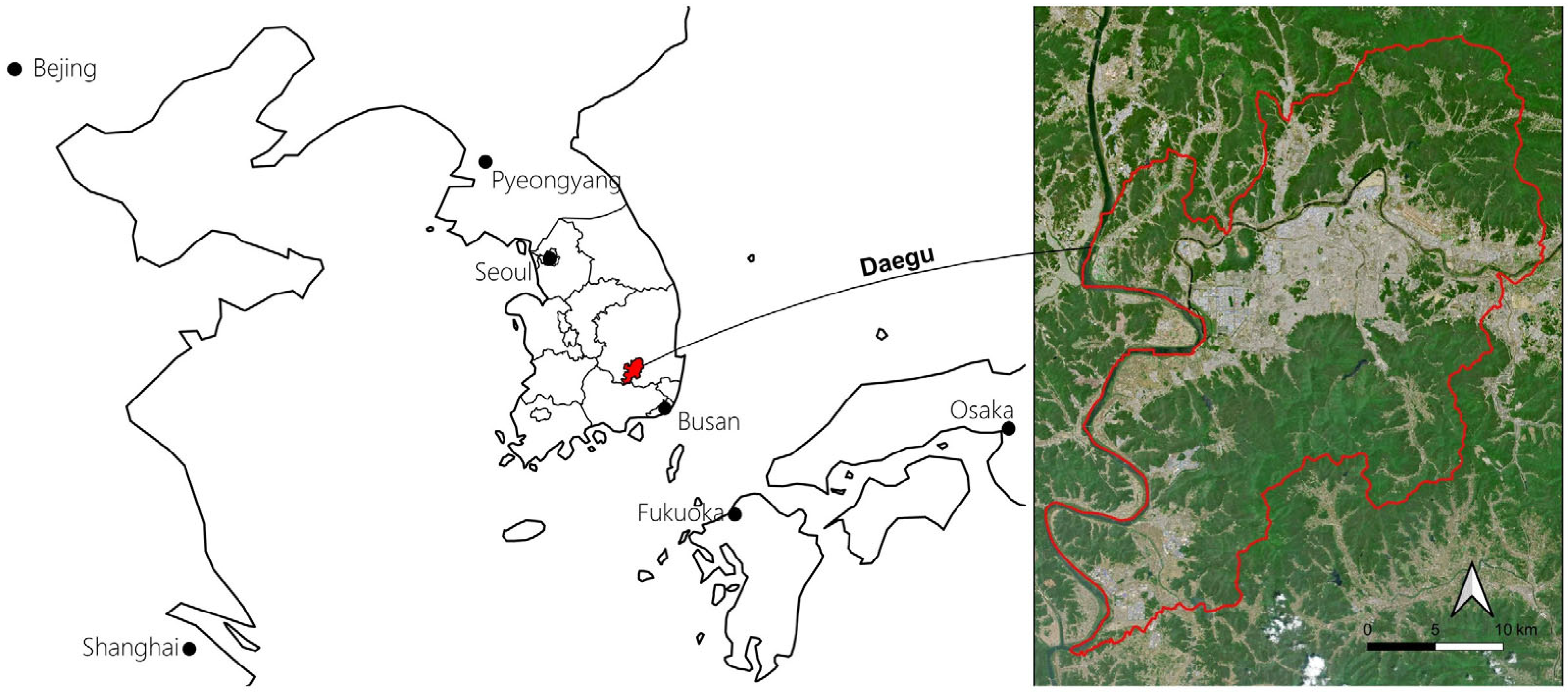
2.1. Daegu Case Study

Daegu is a historical city in the southwest inland of the Korean peninsula (Figure 1). It was the capital of the Gyeongsang region from 1601, and subsequently of North Gyeongsang after the region was divided in 1891. Until the end of the rural Joseon era in 1897, Daegu was a small walled city harboring the region’s command post. The city started to expand and industrialize under the Japanese colonial rule from 1910–45. After the Korean War (1950–53), Daegu developed very rapidly. The population grew ten-fold between 1950 and 2000 to 2.5 million inhabitants. Daegu progressively integrated its surrounding areas into its administrative district, which reached an area of 885 km2 in 1995, when it was incorporated as Daegu Metropolitan City, independent of North Gyeongsang Province [71,72]. As of 2022, Daegu Metropolitan City is the third most populated urban area in Korea, with 2.4 million inhabitants, after the 26.1 M inhabitants of the Capital Region (Seoul 9.4 M, Incheon 3 M, Gyeonggi Province 13.7 M) and the harbor city of Busan (3.3 M). A statistical summary, timeline of the main urban development process, and pictures of Daegu can be found in Supplementary Materials Figures S2–S4.
In the 1960s to the 1980s, Daegu was at the forefront of Korean industrialization, notably with its textile industry. However, large spans of its industrial tissue have now become obsolete, and the city is struggling to find new economic drivers. Daegu now displays the fastest population loss among Korean metropolitan cities. Lacking the global attraction of the Seoul Metropolis, or the asset of Busan’s international harbor, Daegu became a characteristic example of a regional shrinking city in Korea [11].
Daegu’s administrative territory encompasses most of the metropolitan area, with the exception of Gyeongsan City and its 236,000 inhabitants. Daegu Metropolitan City can thus be considered an appropriate unit for large-scale urban analysis. Not only does Daegu offer a representative case to examine the urban decline of Korean cities experiencing post-industrial economic stagnation, but the city is also a convenient ground for urban form observation and generalization. Its relatively flat topography and lack of extreme geographic constraints make it a convenient site for observing urban form dynamics without significant spatial distortion. As a large and historically layered city, Daegu contains a full spectrum of Korean urban fabrics—from remnants of traditional hanok neighborhoods to high-rise apartment complexes and mega-developments. It presents a balanced economic structure, avoiding the bias of cities specialized in industry or administration. Although cities such as Gwangju, Daejeon, or Cheongju may share closer demographic and geographic profiles, the urban fabrics observed in Daegu are also present, to varying degrees, in more complex metropolitan contexts like Busan or Seoul. The centralized and standardized nature of urban planning in South Korea further reinforces the relevance of Daegu as a proxy for understanding broader morphological phenomena.

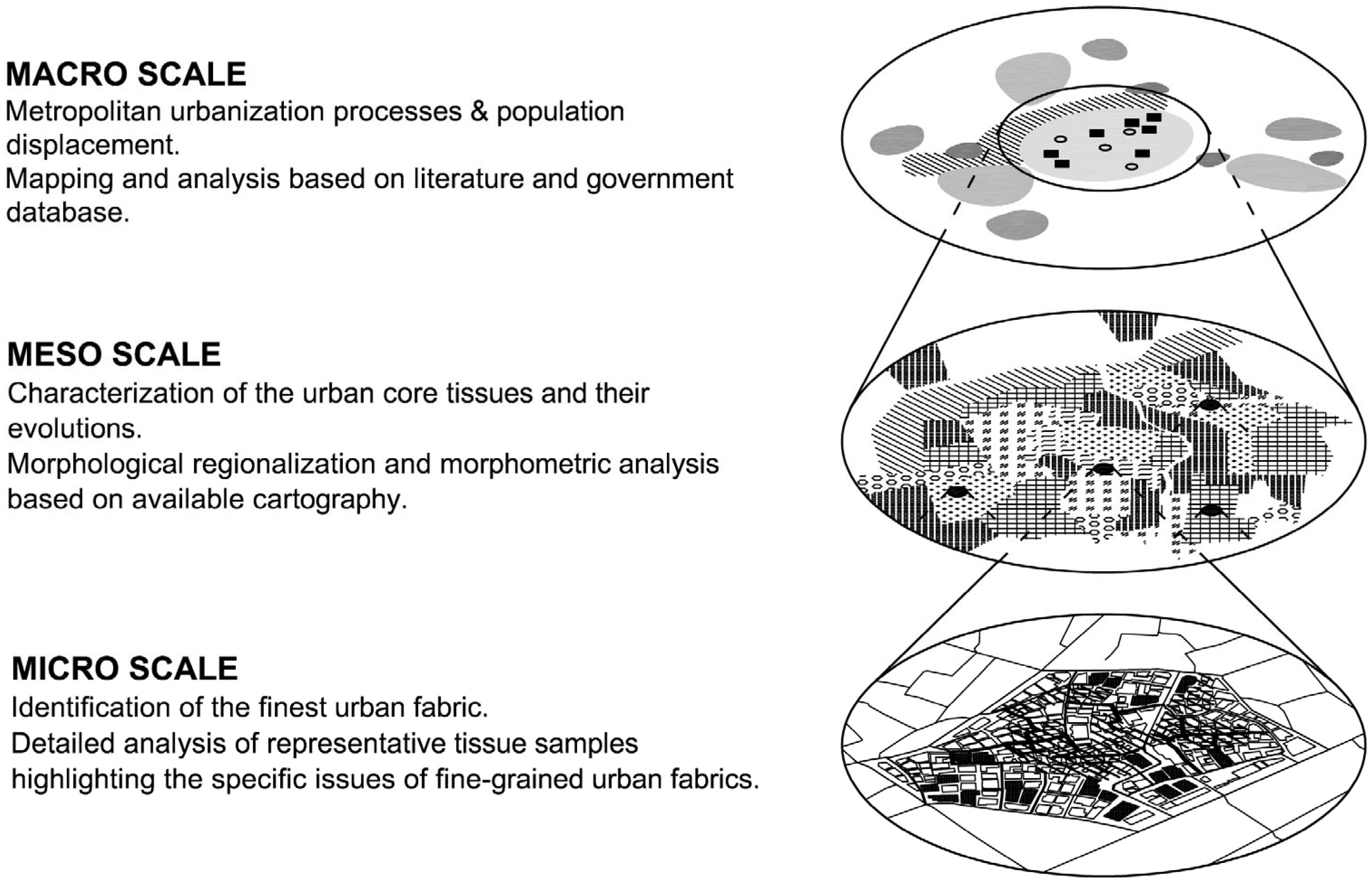
2.2. A Multiscale Approach

Localized urban decay can be attributed to several factors that are related to urban form at various scales, such as the displacement of people and businesses due to urban expansion, and the inherent limitations within the existing urban structures. This research is based on a multiscale approach (Figure 2), including the analysis of the transformative processes of the metropolitan areas (at the macroscale level), urban characterization of the city’s central urban area (at the mesoscale level), and detailed analysis of the city’s different fine-grained urban fabrics (at the microscale level). The research method described in this section was applied to Daegu as an exemplary case study area.

2.3. Macroscale Analysis: Metropolitan Urban Expansion

The displacement of vacancy around the city, associated with urban growth, is a major factor of localized decline. On a large scale, urban regeneration can be defined as the reuse of existing urban area to optimize urban land use and avoid unnecessary urban sprawl [15]. The macroscale analysis aimed to map, quantify, and qualify the processes of urban expansion and transformation at the metropolitan scale. The research focused on housing developments as the main driver of urban change and as the most documented phenomenon. The analysis primarily concentrates on the 2000s and 2010s, with adjustments due to the availability of data. Different urbanization processes were identified and described using the available literature [31,71,73]. The urban transformation mapping identified Housing Site Development [74], Maintenance Areas [73], and Regeneration Areas [75]. The urbanized area was defined on the base of a 30 m buffer around buildings, with a minimum aggregated area of 10,000 m2. These thresholds were selected empirically. The mapping of urban decline reflected official assessment criteria [76]. Demographic statistics allowed the observation of correlations between urban transformation and population movements [77,78,79]. Ongoing development could be described and analyzed in detail using the data released by the city [80].

2.4. Mesoscale Analysis: Central City Fragmentation

The development of harmonious form-based urban planning requires a thorough knowledge of the existing urban form. Based on a 12 km diameter area encompassing the central city in its geographic bowl, the mesoscale study concentrated on the characterization of the urban fabric.
Morphological regionalization was conducted by classifying urban fabric based on formation era, urbanization process, and predominant function. This approach follows methodologies established in studies of London [81], Porto [82], and Rennes [40]. Based on indirect formation criteria, this regionalization is labeled morphogenetic. The explicit mapping criteria and process addressed recurrent reproducibility issues [83,84], limiting discrete arbitrations that would make large-scale regionalization excessively time-consuming. The authors identified and mapped distinct fabric types based on observation and the literature [6,31,71], using the most relevant available data for each tissue. The superposition of the maps followed chronological order, except in the case of relict features of previous eras that called for discrete identification through map observation. Unmapped built areas were attributed a default label depending on their location in the city. Zone edges were drawn following street axis or property limits. A minimum area threshold of 10,000 m2 for punctual tissues addressed the dilution issue, differentiating an isolated exception from a coherent urban fabric.
The Python suite Momepy [85] was used to provide morphometric insights, including unsupervised clustering of urban form [64]. For the calculations, the morphological tessellation buffer was set to 30 m. To limit the computing workload, buildings with a footprint of 20 square meters or less were ignored. Building height was approximated by multiplying the building level data included in the GIS dataset by three meters.
The observation of ongoing changes comprised the identification of apartment complex superclusters, defined as regions buffered by 50 m that will exceed 50,000 m2 once all ongoing projects are completed. Conversely, the fragmentation of urban fabric was assessed using region size moderated by its rectangularity [86]. Holes under 20,000 m2 were ignored to identify coherent areas over 400 m in diameter, including even large schools in this analysis.

2.5. Microscale Analysis: Fine-Grained Neighborhoods and Urban Density

In a context of depopulation, neighborhoods are faced with harsh competition for survival. The intrinsic congestion and fineness of the old low-rise city makes it the least adapted to contemporary demand: decline and decay concentrate on the fine-grained urban fabric [10,87].
The mesoscale study data facilitated the mapping of the most fine-grained areas. At the microscale, the authors selected a panel of fabric samples presenting a mean inter-building distance of 6 m or less as the basis for in-depth observation of the various configurations of fineness and congestion. Two samples of each fine-grained urban fabric type, as identified by morphogenetic regionalization, were included in a search for the greatest variety of configurations. The sample areas ranged from 2.6 to 3.7 ha. The samples were mapped using the following fineness indicators: street width, plot size and shape, accessibility, building gross floor area, and the presence of collective housing. Offcut plots were defined as flat or triangular plots under 200 m2 that arose from opening a new street in an existing urban fabric. Additionally, the floor area ratio, building coverage ratio, and public space ratio were calculated for each sample.
The notion of small collective housing in Korea is unclear, as it has three contrasting definitions: (i) multihousehold condominium, (ii) multifamily individual housing, and (iii) retail housing mix. Identifying all small collective housings required visual confirmation and consultation of the building register on the Daegu 3D map portal [88]. Field observations were conducted in the six neighborhoods to verify GIS inconsistencies, particularly in older areas where the cadastral data did not align with the building footprints. The two maps were corrected and adjusted manually as best was possible, yet the final sample mapping needs to account for many small-scale imprecisions.

2.6. Data Collection and Analytical Tools
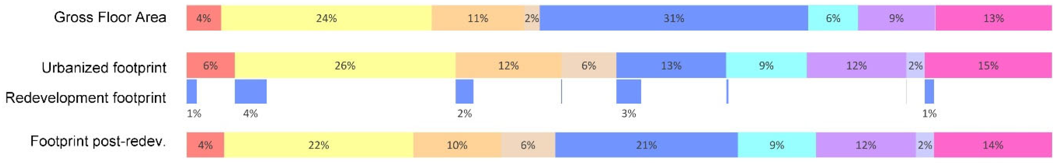
This research used data and cartography provided by public Korean institutions. Cartographic data were sourced from the Continuous Digital Topographic Map GIS database dated from 2019 [89]. Cadastral plans were obtained from the ‘Land Use Planning Spatial Information’ GIS database [90]. QGIS 3.16 [91] was used for geospatial processing, including buffer analysis and spatial clustering. Morphometric analysis was conducted using the Python 0.5.0 suite Momepy [85].
The analysis primarily captures the urban condition and transformation between 2000 and 2020. Historical comparisons rely on datasets spanning the early 2000s to 2020. However, for redevelopment and reconstruction zones, the most comprehensive and official source available was the 2013–2020 maintenance plan. This was updated manually using the Naver Real Estate website [92] to spot unchartered projects. For regeneration zones, our focus was deliberately limited to the more consistent 2018–2025 New Deal Regeneration Projects, which present cohesive goals and methods, unlike earlier scattered initiatives.

3. Results

The results section is structured according to the multiscale framework. At the macroscale, analysis offers a mapping of the various developments in the past 20 years and examines their correlation with urban decline indicators and demographic movements. The analysis of housing stock and ongoing developments reveals the current trend toward high-rise concentration. The specificities of redevelopment and regeneration procedures are exposed. The mesoscale analysis consists of a morphological regionalization supported by a morphometric characterization of the defined regions. This enables a comparative reading of built fabric types and reveals ongoing consolidation or fragmentation trends linked to macro-level dynamics. At the microscale, a focused investigation of representative fine-grained urban fabrics, selected through the mesoscale mapping, provides insight into spatial congestion and accessibility challenges. This scale-specific lens enables a comprehensive understanding of the structural and policy-related challenges affecting urban regeneration in Daegu.

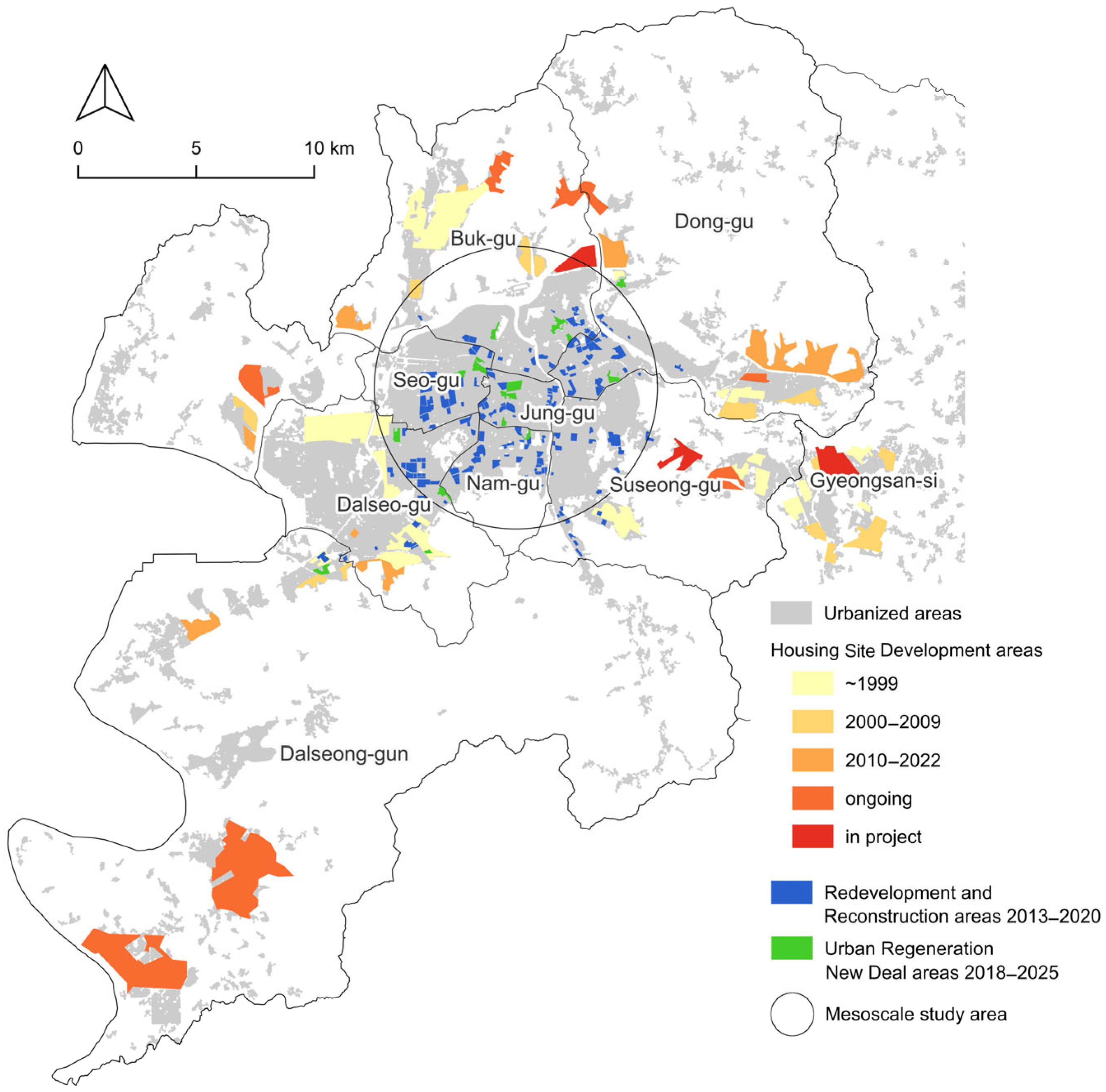
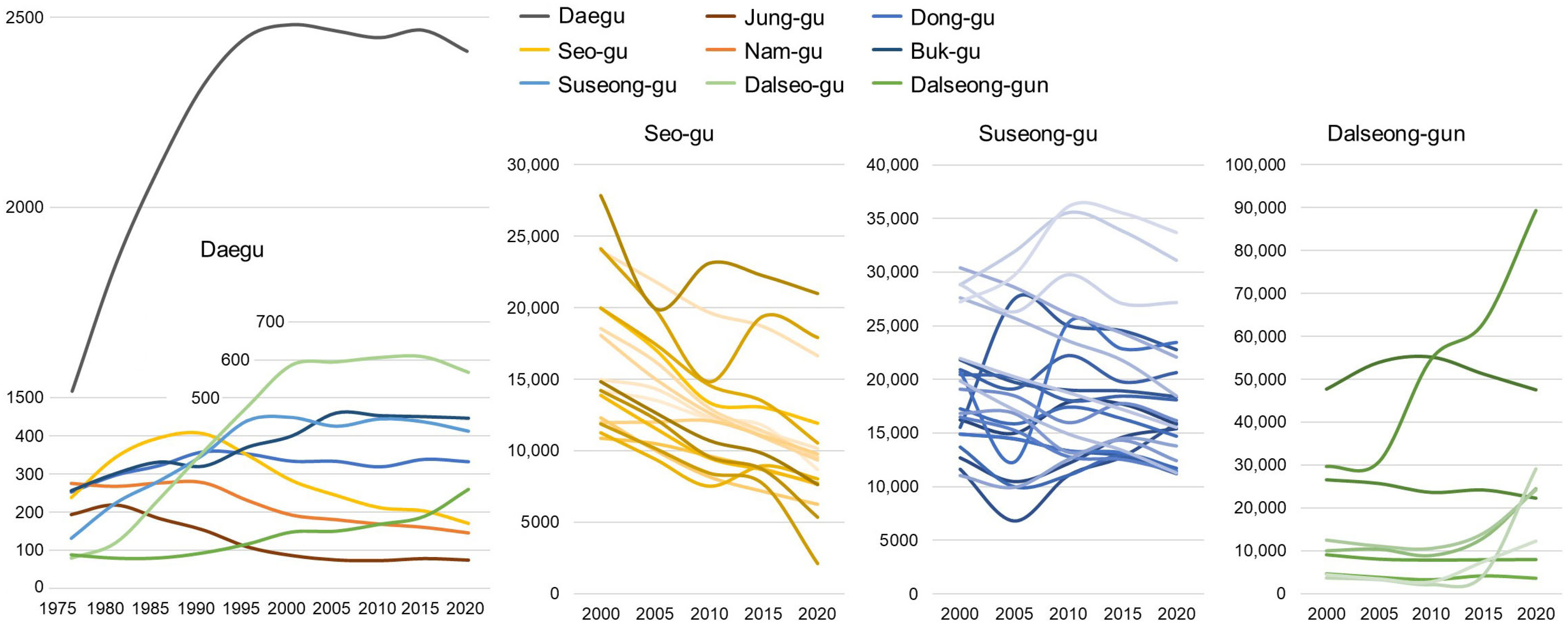
3.1. Macroscale: Expansion, Displacement, and Concentration

The first major expansion of Daegu occurred within its geographic bowl until the 1980s, corresponding to the mesoscale study area indicated in Figure 3. This expansion was based on the Land Readjustment (LR) procedure, characterized by small plot and individual or small collective housing. The second expansion consisted of satellite new towns in adjacent valleys following the Housing Site Development procedure [31,71]. The new town mainly consisted of dense apartment complexes. A detailed mapping of Daegu’s urban expansion is available in Supplementary Materials Figure S5. Housing Site Developments are mapped in Figure 3 [74]. Initially a response to explosive growth and overcrowding, these developments were later considered the primary cause of city center desertification [10,27]. In contrast to the expected national rebalancing, the recent development of Dong-gu Innovation City drew its population mainly from the surrounding districts, notably the depopulating inner city [93].
The evaluation of decline and decay is a complex process that touches on the definition and aims of regeneration policies. While easily noticed on-site, physical signs of decay, neglect, and disuse are hardly quantifiable on a large scale. In Korea, urban decline is assessed statistically at the administrative neighborhood scale (Korean: dong) through three criteria [94]:
  • Population Decline: A decrease of more than 20% over 30 years and a consecutive decline over 3 years.
  • Business Closure: A reduction superior to 5% over 10 years, with three or more consecutive years of decline.
  • Building Age: More than 50% of the building stock exceeding 20 years.
These criteria for 2020 [76] point to the city center (Figure 4), where depopulation has been the main justification for large wholesale redevelopment programs [95].
Figure 5 shows that Daegu’s population peaked in 2000, driven by the growth of peripheral districts, while central districts (Jung-gu, Nam-gu, Seo-gu) began shrinking as early as the 1980s [77,79]. The evolution at the neighborhood scale shows strong variations, with characteristic dips due to wholesale demolitions, followed by a rebound after project completion. Neighborhoods inside the same district experience different fates. In the industrial Seo-gu, redevelopments fail to remediate the fast depopulation and are mere upticks on a descending curve. In affluent Suseong-gu, redevelopment enables some areas to maintain or increase their population, while others continue to decline. Meanwhile, the remote greenfield developments of Dalseong-gun concentrate the population in a few development areas, leaving the rest of the rural district stagnant [78,79].
The housing urban plan for 2010–2020 [73] designated maintenance zones amounting to 9 km2, concentrated in the central city area, where they represent around 10% of the urban land (Figure 3). So-called ‘maintenance projects’ are divided between ‘redevelopment’, providing basic infrastructure provision in deprived areas, and ‘reconstruction’, targeting old low-rise districts or aging housing complexes with sound infrastructure. The inventory of ongoing collective housing developments released by the city [80] provides a good overview of the projects’ trend toward bigness (Figure 6). Greenfield developments make up 30% of the overall developed land area and only 20% of the total floor area, making the reuse of already urbanized land the dominant paradigm. Among this reused land, 40% escapes the monitoring of the maintenance plan, notably the mixed developments with a surface of non-housing over 10% in commercial urban zoning (Korean: chusangbokhab). Project sites are considerably large, varying from one to seven hectares, with an average of three hectares. The legal floor area ratio (FAR) typically falls within the (250–280)% range, consistent with the zoning regulations for residential areas [73]. However, some projects in commercial zones reach more than 800%, reflecting extremely high-density development. The floor number averages 27, with peaks above 40 illustrating the radical verticalization of the city.
Large-scale apartment complexes now dominate Daegu’s housing market, accounting for 56% of the city’s housing stock as of 2017 (Figure 7). Small-scale tenements (Korean: dakaku) constitute the main alternative, while mid-scale condominiums (Korean: dasaedae and yeonlib) and individual housing represent only a fraction of the stock [96].
The designation of a ‘maintenance area’ requires a threshold proportion of ‘dilapidated’ (Korean: nohu bullyang) buildings that vary, depending on the sub-category of development: two-thirds for redevelopment and 10,000 m2 or 200 houses for reconstruction. Depending on the type of structure, a building qualifies as dilapidated after 20 or 30 years. Additional redevelopment criteria include road widths under four meters and plots smaller than 90 m2 [73]. Designation as a redevelopment area often leads to the neglect of existing buildings as residents await demolition. However, projects must undergo multiple validation steps, including the approval of 75% of landowners [73]. When market conditions make compensation unattractive, projects remain stalled or are eventually canceled, leading to severely deteriorated ‘canceled maintenance areas’ [97]. Redevelopment projects are inherently growth-based, as the high cost of existing property purchase, demolition, and infrastructure provision can only be financed by a significant increase in real estate quantity. Although poorly documented, the available data [98] suggest that redevelopment results in an average increase in housing units of 240% (Supplementary Materials Figure S6). The gap in gross FAR between apartment complex tissue exceeding 280% and low-rise tissues hovering around 100% observed in the morphometric regionalization part 3.2 also constitutes a good approximation of this increase. Redevelopments provide public infrastructure and utilities at the developers’ expense on the project site and around it. The ‘donation collection’ (Korean: gibuchaenap) rule allows for FAR incentives in exchange for contributions to parks, roads, sewers, and schools [99]. Since infrastructure provision can be privately funded, the public sector lacks strong incentives to invest in neglected areas. Issues such as sewer odors, unmanaged waste, and inadequate parking exacerbate the deterioration of the ‘old city’. As a result, Korean urban spaces are divided into privately financed modern developments and aging, infrastructure-deficient districts, where modest households live in outdated homes and substandard dakaku tenements [100].
Korean redevelopment practice is a form of ‘property-led regeneration’, based on the idea that the input of new housing and population will bring new buoyancy to an area in difficulty. However, this approach, often associated with displacement and gentrification, has been widely criticized for failing to address social issues [16,101,102]. As a result, Korea has begun exploring a more holistic regeneration model, though its implementation remains nascent. The ‘Regeneration New Deal’, launched in 2017, encompasses 16 Area-Based Initiative projects in Daegu [75], represented in Figure 3. Their scope ranges three to five years and five to twenty hectares for a budget of KRW 5 to 15 billion (EUR 3.4 to 10 million). The budget is allocated to community and local business development, as well as the improvement of public space and public facilities, excluding the direct improvement of private housing. New Deal regeneration projects in Daegu cover 194 ha, only a fifth of the redevelopment and reconstruction areas for 2013–2020. Regeneration initiatives remain episodic, driven by individual politicians and activists [25], and have yet to be institutionalized [103].

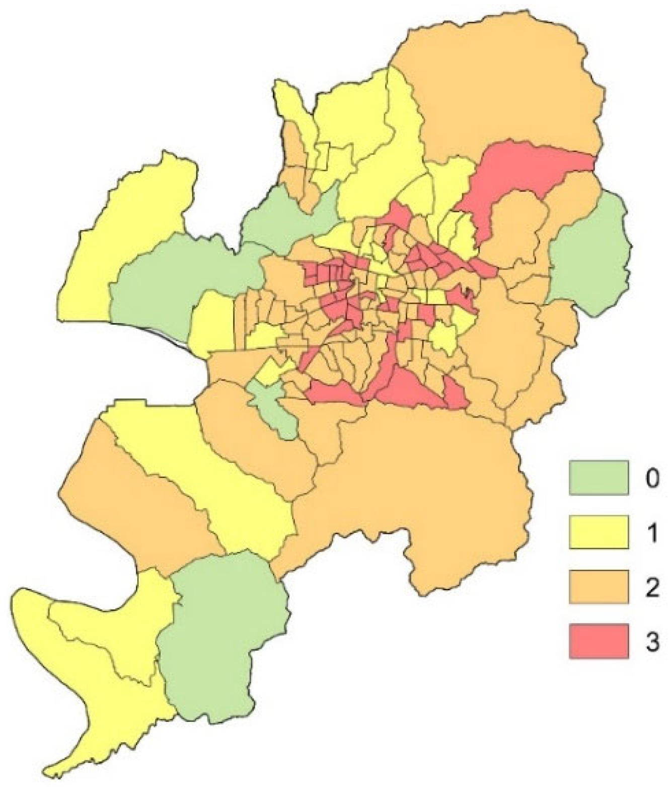
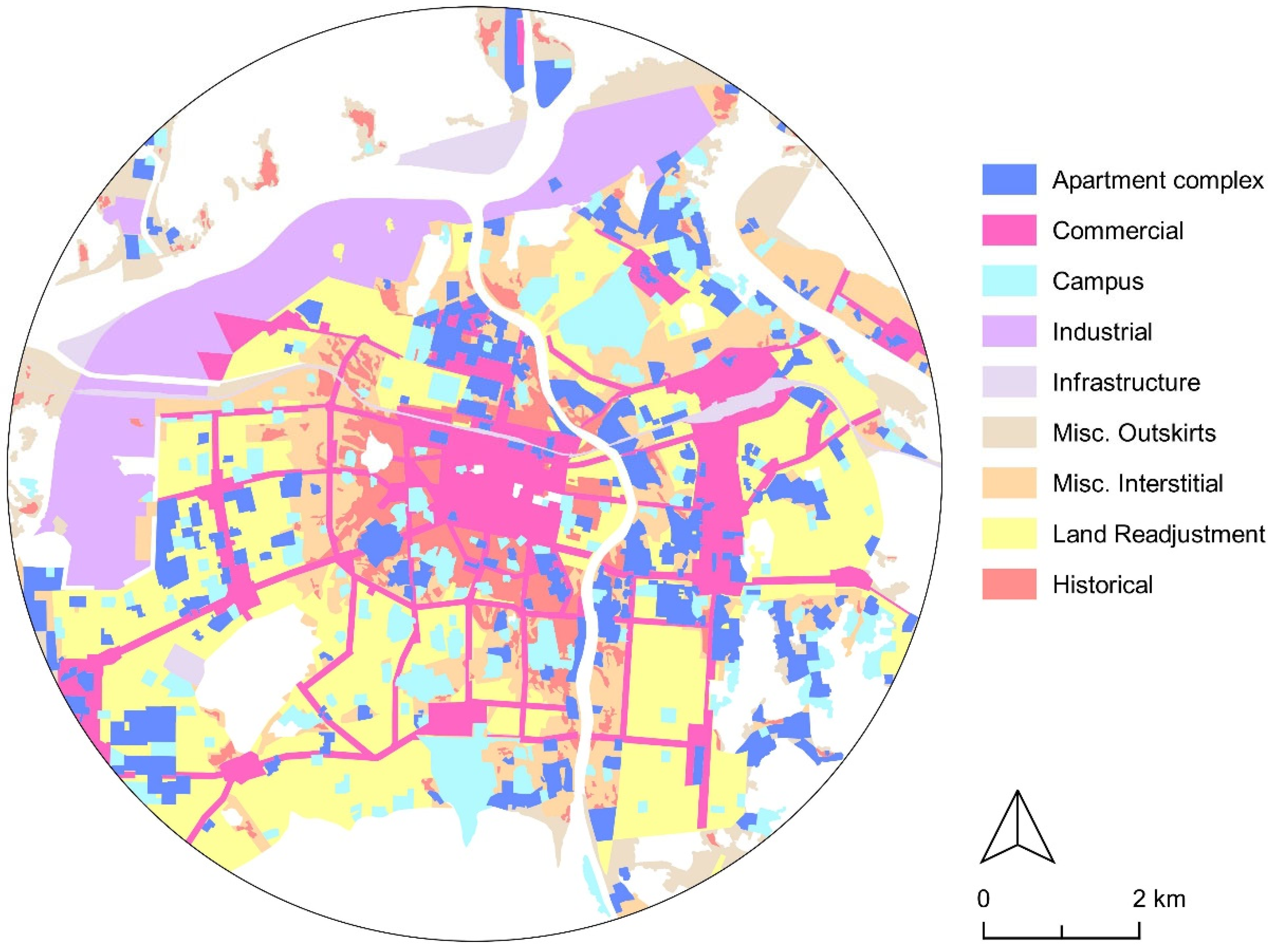
3.2. Mesoscale: Central City Fragmentation and the Survival of the ‘Old’ Low-Rise City

The large-scale morphological regionalization developed in this study uses the tissues defined in Figure 8 to produce the map in Figure 9. The research identified nine tissue categories:
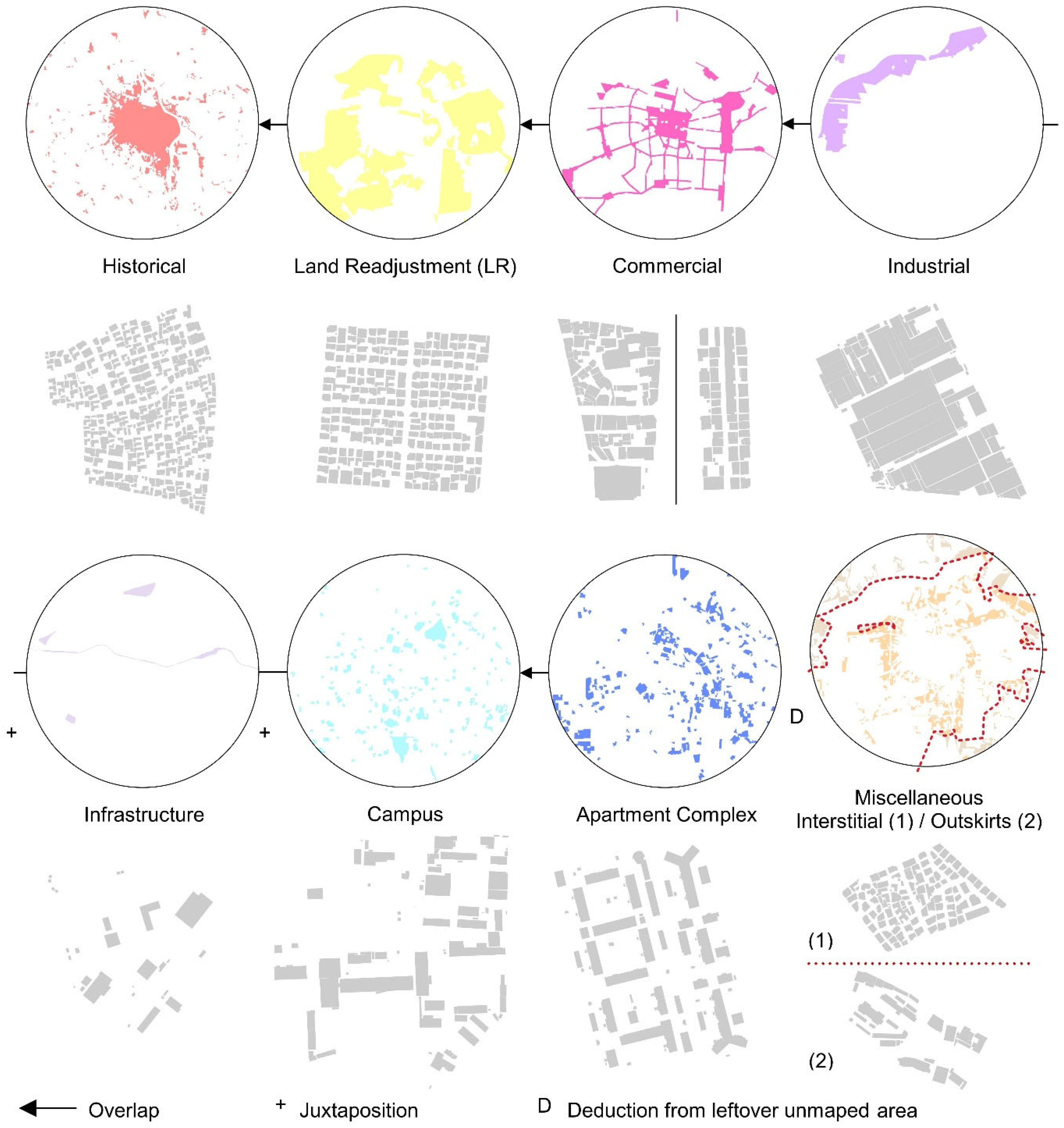
  • Historical: Fine, organic patterns and remnant historical buildings defined by the outline of urbanization at the end of the Korean War, mapped using the 1954 US aerial photography campaign [89].
  • Land Readjustment: Fine gridiron patterns with low-rise habitat resulting from LR developments between 1940 and 1983, mapped using the Daegu Land Readjustment White Book [104].
  • Commercial: Dense heterogeneous areas formed under the highly permissive commercial zoning in place since the Japanese occupation. The existing commercial zoning as of 2022 served as a proxy to map these areas.
  • Industrial: Packed, low-rise warehouses and factory complexes established in the 1960s to 1980s identified through legal zoning and observation.
  • Infrastructure: Scarcely built large transportation and sanitation footprints identified through GIS data and observation.
  • Campus: Schools, army bases, government, and sports institutions over 10,000 m2 adopting a loose and airy building pattern, mapped using legal zoning, GIS data, and observation.
  • Apartment Complex: Clusters of large apartment housing exceeding 10,000 m2 mapped following the housing category in the GIS database.
  • Miscellaneous Interstitial: Remaining uncharacterized urban area located in-between identified tissues. This mainly corresponds to informal developments of the 1950s to 1970s in between the historical and LR regions.
  • Miscellaneous Outskirts: remaining uncharacterized urban areas located along infrastructure and green areas at the edge of the city. These fringe zones tend to be the least consistent.
To complement the morphogenetic regionalization, an unsupervised morphometric clustering analysis using Python was performed, based on Fleischman’s Numerical Taxonomy [64]. The resultant map, available in Supplementary Materials Figure S7, shows concordance at the larger scale. Clear-cut fabrics, such as the packed industrial tissue and the clear LR gridiron, are well identified, while some more irregular grids, often distorted by the topography, are associated with organic interstitial and historical regions. Coarser fabrics, like apartment complexes and campuses, tend to end up in the same clusters, and region edges are blurred and imprecise. For these reasons, the study focused on the first morphogenetic region, using the morphometric data produced by the numerical taxonomy process to characterize it.
Selected morphometric characters in each morphogenetic region highlight some of the most clear-cut characteristics of the various fabrics. Figure 10 illustrates the distribution of morphometric characteristics across the different urban fabrics. The boxplots depict unweighted values for individual buildings rather than aggregated area averages, allowing for a fine-grained analysis of morphological differences. A mapping of each selected morphometric character can be found in Supplementary Materials Figure S8. The results show how the city is divided between congested small building areas—historical, interstitial, and LR tissues, hereafter termed fine-grained fabrics—and bulky, airier fabrics, notably the apartment complexes that overwhelmingly dominate the skyline (building footprint area, tessellation cell area, and building levels). The neighborhood tessellation cell gross floor area ratio hovers in the 100% range, except for apartment complexes, which exceed 220%. The block size for fine-grained fabric lies in the 0.5 ha range, while in the apartment complex, it exceeds 3 ha, suggesting a better walkability of the fine-grained fabrics. Finally, street linearity reveals the organic nature of spontaneous old fabric development, in contrast to the grid of Land Readjustment areas. The coarser fabrics display a large spread in data values, denoting heterogeneity, while fine-grained fabrics show consistent and similar properties. The distinction between the historical and interstitial fabric is unclear: the 1954 threshold used for mapping turns out to be more of a historical indicator than a turning point in the formation of spontaneous urban tissue.
-
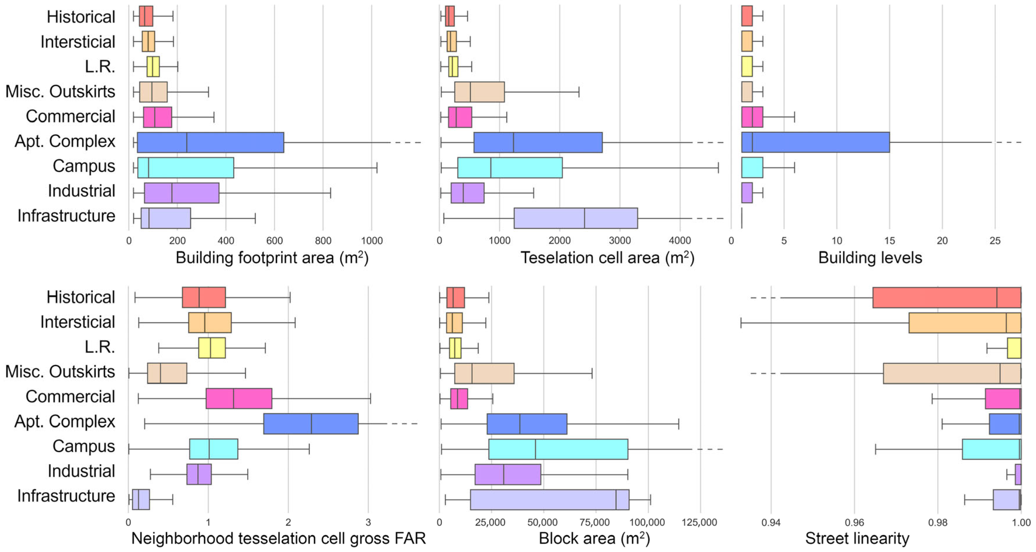
The tessellation cell is the polygon surrounding a building, defined such that any space within it is closer to that building than to any other building. It is used as a more consistent replacement to the cadastral plot.
-
The neighborhood tessellation cell gross FAR represents the average gross floor area ratio of a tessellation cell combined with its surrounding cells within a topological distance of three cells. This measure helps to better visualize clusters of density.
-
Street linearity represents the deviation of a street segment from a straight line (linearity = 1). The smaller the number, the more meandering the street.
Fine-grained fabrics represent the largest footprint in the study area, occupying 44% of the urbanized surface, with LR tissues alone representing 26% (Figure 11). Apartment Complex tissues provide 31% of the total gross floor area for only 13% of the urbanized surface. With 11% of the study area engaged in redevelopment, the importance of apartment complexes will grow significantly in the coming years. Redevelopments target all fine-grained tissues rather indiscriminately: historical 22%, interstitial 17%, LR 15%. If all scheduled redevelopments were to be completed, the footprint of apartment complexes would almost double, reaching 21%. However, the fine-grained fabrics would remain the dominant land pattern, with a combined 36% footprint.
Before their intrinsic problems, the fate of fine-grained fabrics might be a function of their situation in relation to adjacent fabrics. We identify three distinct situations (Figure 12):
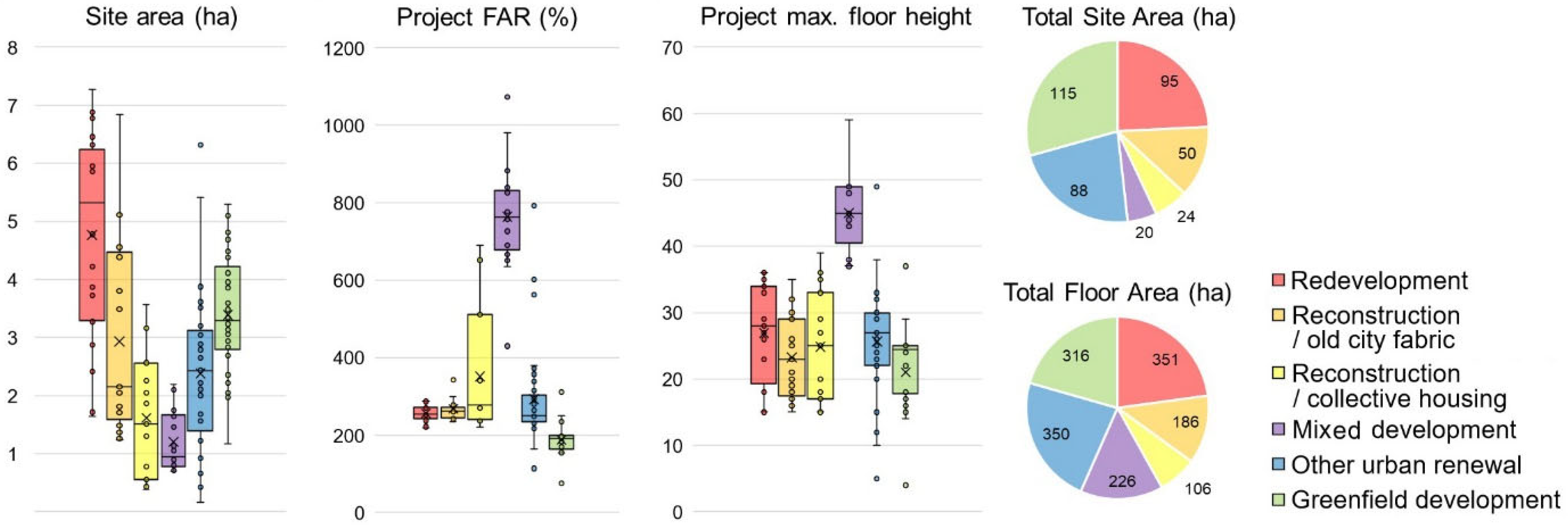
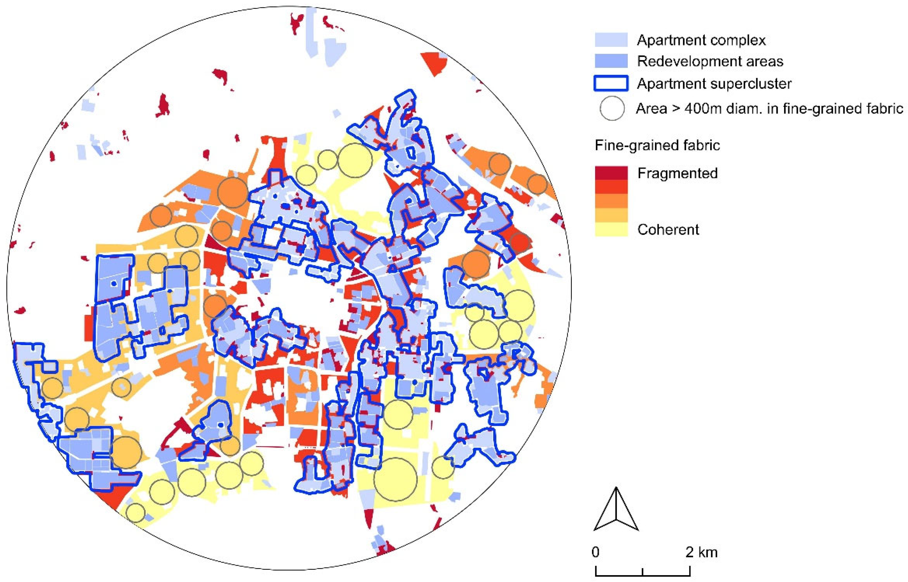
  • As redevelopment progresses, apartment complexes form ‘superclusters’ that include small leftovers of the low-rise city. Outscaled by their surroundings, those fragments lose their residential attractiveness. In the right condition, they are repurposed as shops and cafes, offering pockets of charm and vibrancy to the population of the monotonous bars and towers. In other cases, they remain as awkward semi-derelict pockets, too small or complex to attract redevelopment.
  • Where apartment complexes become more spaced out, a mix of small patches of various fabrics coexist. Hybrid neighborhoods form, with issues of transition and harmony between the various patches.
  • Some low-rise residential districts, notably LR areas in the periphery, remain coherent on a larger scale. Approximately 30 urban nuclei, each exceeding 400 m in diameter, are identified as potential independent neighborhoods [105]. A third of those areas correspond to the ‘Type 1 residential area’, where large apartment buildings are prohibited (see Supplementary Materials Figure S9). Yet, zoning changes easily, and they cannot be considered protected.
Recognizing these patterns is essential for future redevelopment and urban regeneration strategies.

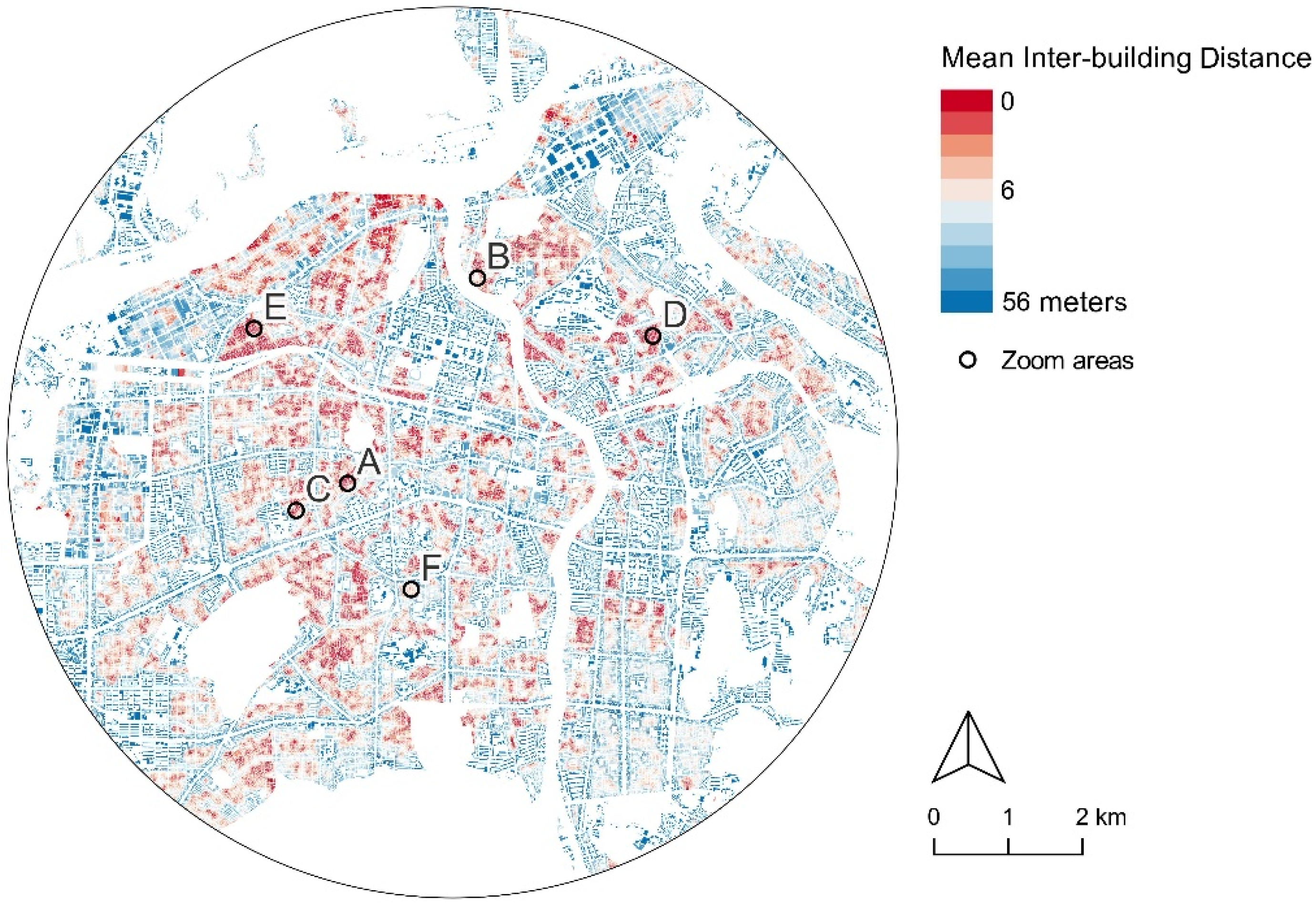
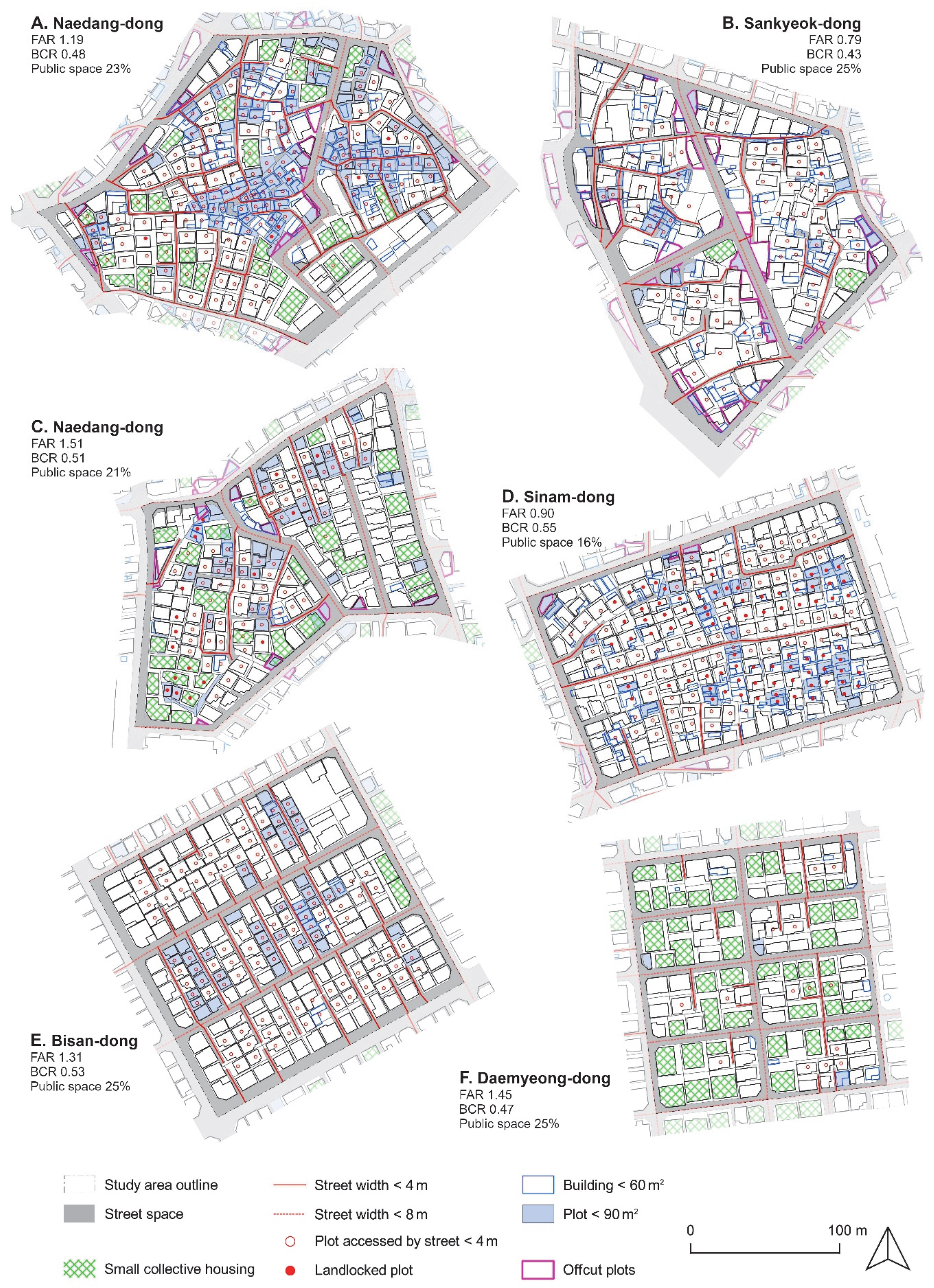
3.3. Microscale: Fine-Grained Neighborhoods and Forms of Congestion

A series of studies by the Architecture and Urban Research Institute of Korea [29,30,106] has identified key challenges to the plot-based renewal of the so-called ‘detached house dense area’. These challenges can be categorized into three interrelated issues:
  • Excessive fragmentation of the urban fabric, characterized by small plots and narrow streets.
  • Insufficient open space, green space, and parking facilities.
  • Incompatibility of existing urban codes with these fine-grained urban structures.
Streets under 4 m wide, plots in the second rank from the street, street ratio inferior to 20% of the total surface, and the absence of parking space constitute indicators of poor accessibility of the urban fabric, especially for automobiles. Plots under 90 m2, irregular plots, and building gross floor areas (GFAs) under 60 m2 outline the excessive fragmentation of the land that limits development opportunities.
The extent of congestion in these urban fabrics is effectively visualized using the Mean Inter-Building Distance metric, calculated using Momepy. This index calculates the average distance between a building and its neighbors averaged on a three-step topological distance to render the state of congestion of the urban fabric (Figure 13).
The high FAR allowance and the insufficiency of right-to-light and setback rules trigger a phenomenon of overbuilding and overcrowding that is hardly manageable in fine-grained urban fabrics, such as those indicated in red on the map. Notably, congestion levels exhibit significant variation across different fine-grained neighborhoods. The large spans of low-rise fabrics on the eastern and western edges of the center are much airier than the crammed neighborhoods in the center and northern part of the city.
Figure 14 presents a detailed analysis of six fine-grained fabric samples with a Mean Inter-Building Distance of less than 6 m. Samples were selected to include the largest variety of forms and cases. Samples A and B belong to the historical region identified in the mesoscale study, C and D to the interstitial region, and E and F to the Land Readjustment region.
Sample A, in Naedang-dong, is a peri-central area developed during the Japanese occupation. It is among the rare central historic areas of this size that have not been extensively transformed or redeveloped. A new street pierces through a fabric of intricate narrow lanes and micro properties. Some 59% of the plots are either inaccessible or accessible through an alley less than four meters wide, 48% are under 90 m2, and 51% of buildings possess a GFA under 60 m2. The cadastral map poorly matches the build layer, and the alleys are imperfectly registered. Despite this congestion, several small collective housing buildings were built at the bloc’s periphery, while the center remains cluttered with makeshift low-rise housing. The site is not under any redevelopment project, and the redevelopment site on the southeast opposite the main road seems to be stalled.
Sample B, in Sankyeok-dong, presents the remains of a traditional village. New access roads were cut through the fabric, and accessibility is better than in sample A. Yet, in the absence of a subsequent plot readjustment, numerous small and angular offcut plots (Korean: jaturittang) were formed in the process. The borders of the new roads remain scarcely built and are used as scrap material storage, vegetable gardens, or just left empty, resulting in a significantly lower FAR than the other samples. Conversely, poorly accessible old buildings clutter the center of the new blocks. The neighborhood sits aside from the main transportation axis in the city. No development plan exists, and the area will likely experience further stagnation.
Sample C, in Naedang-dong, was developed in the post-war period near the city center. It first consisted of urban hanok (traditional Korean houses) on a rural cadaster. The built fabric densified over the years to create a compact aggregate of small collective and individual housing three to four levels high, deprived of external space. Many buildings do not respect the basic setback and coverage ratio rules. Inconsistencies in most buildings’ registry dates and surfaces suggest that they were built without public control and later registered. Despite poor accessibility and spatial congestion, the odds for redevelopment of the area are low due to the already high density of construction and the numerous property owners to compensate.
Sample D, in Sinam-dong, consists of small-scale piecemeal housing developments from the 1970s and 1980s. The cement hanok and brick courtyard villas remain, rarely exceeding two levels. With a single street under four meters wide to serve the area, accessibility is limited. Many properties are legally landlocked, accessed only through unregistered narrow lanes between houses (38%). Plots under 90 m2 represent only 18% of the plots, among which 4% are offcuts and reservations for the regularization of alleys. Buildings under 60 m2 GFA represent a sizeable 46% of the stock, amongst which 22% are shack additions classified as non-housing. Despite these problems, the neighborhood is functional and still inhabited. While it is part of the Sinam New Town redevelopment area, no deal has yet been concluded with a developer.
Sample E, in Bisan-dong, is an example of Land Readjustment on flat rice paddies from the 1960s. This is among the most fine-grained LR fabrics in Daegu. Those developments were meshed to accommodate the highest density of individual housing in a pre-automobile period. The east–west collector streets range six to eight meters in width, while north–south alleys are below four meters wide, resulting in a 52% ratio of poorly accessible properties. While the urban grain is very tight, few plots and building floor areas are under the 90 and 60 m2 thresholds, at 22 and 4%, respectively. Despite a functional street and plot pattern, these fabrics are too intricate to accommodate today’s car-based lifestyle and higher building density. Moreover, redevelopment might not be an option, as the proximity of the polluting Daegu Dyeing Industrial Complex reduces the attractiveness of the area. Despite those limits, the neighborhood is zoned as an ‘adjunct residential area’, allowing for FARs up to 400%. Only one small redevelopment project is underway in the whole district of Bisan 7-dong.
Sample F, in Daemyeong-dong, is a Land Readjustment development from the 1950s. Based on the first Japanese LR examples, it has comparatively smaller blocks and larger plots, most accessible through a six- to eight-meter-wide road. While still fine, this fabric is accessible to cars. Buildings were redeveloped into sub-standard dakaku tenements, which now represent 43% of the stock. Many buildings have parking lots occupying the ground floor, turning the streetscape into a barren car park. Reaching up to four levels and composed of small housing units, they cause overbuilding and overcrowding. As poorly attractive rental units, dakakus are affected by high tenant turnover and landlords who do not live in the neighborhoods, which results in neglect of the environment. Despite its relatively favorable urban structure, this area faces challenges related to social decline and poor maintenance [27,107].
While the samples all have a gross building coverage ratio (BCR) of around 0.5, their gross floor area ratio ranges from 0.79 to 1.45. Similar numbers can be observed in two studies by the Architecture and Urbanism Research Institute of Korea on samples in Gwacheon, Yeongju, Suwon, Anyang, Seoul, Jeonju and Daegu [29,106]. All samples in our study present a public space ratio slightly above 20%, with the exception of Sinam-dong with 16%. However, this public space is spread thin amongst many narrow alleys, and in consequence, no open space is available. Despite a common urban scale, the congestion issue varies from case to case. Poor accessibility, excessive smallness, overbuilding, deficient or irregular cadaster, and the like form an array of problems that hinder spontaneous urban renewal. However, all the visited neighborhoods remain inhabited and can present a certain charm. It remains to be seen which areas can, with the proper adjustments, be brought up to modern living standards.

4. Discussion

The results of this research call for a structured critique of the current urban regeneration practices in Daegu, emphasizing how macroscale planning decisions often produce unintended consequences for the most vulnerable urban areas. It focuses on four central themes: (i) generalized high FAR limits foster growth-based redevelopment as an alternative to management and renovation, rendering buildings expendable; (ii) large-scale redevelopment policies trigger constant population movements, destabilizing neighborhood structures. Ever bigger developments engage in an unsustainable competition for views and private amenity provision, supplanting public power and inducing segregation; (iii) flawed criteria for assessing decline and decay, under the influence of a developmentalist planning mindset, exacerbate localized decline and decay; and (iv) the vacancy induced by the growth-based practices in a time of demographic shrinkage focuses on the most challenged areas—the congested very-fine-grained urban fabrics.
This section then explores form-based alternatives to current zoning practices, including the adjustment of development scales, density caps, and adaptive design strategies. It also evaluates the achievements and shortcomings of existing policies in Korea. The section concludes with reflections on data limitations and potential directions for future research.

4.1. Urban Growth vs. Building Life Cycle: The Expandability/Expendability Paradox

This study highlights the dual phenomenon of expandability—boundless urban growth potential—and expendability—quick discard of aging buildings—at the heart of Korean neighborhood decay. The current expandability of the urban mass in Daegu is characterized less by horizontal expansion than by vertical concentration in high-density redevelopments. This phenomenon can be noticed throughout Asia, such as the very speculative case of ‘vertical accumulation’ in Hong-Kong [108] or the example of Tokyo, where concentration is used as a ‘spatial fix’ to answer shrinkage and preserve real estate capital [109].
The high FAR allowance of the zoning code results in a city that never reaches maximum capacity. As of 2016, Seoul was estimated to fill 70% of its legally buildable floor area [110]. A similar estimation for our central study area suggests an achieved FAR of 46% (Supplementary Materials Figure S9). By allowing high densification throughout the urban area, urban planning forfeits its potential to orient the macromorphology of the city. Urban expansion patterns are influenced by speculative market dynamics, where developers prioritize high-density projects based on financial returns rather than holistic urban planning principles.
Urban regeneration can be defined as re-investment after a period of disinvestment [111]. The observed concentration of investment and population on a small portion of the urban land in a period of demographic shrinkage inevitably results in disinvestment in other areas. The land is valued for its real estate yield potential, and buildings become expendable. Redevelopment laws facilitate the quick discard of large spans of the built fabric. The resulting uncertainty regarding urban management discourages building maintenance, intensifying expendability.

4.2. Challenges of Large-Scale Redevelopment in Daegu

Redevelopment projects in Daegu reached an average surface of 2.6 ha in 2019. The increasing size of architecture and urban projects is associated with issues such as the need for old buildings and gradual investment [112]. A diversity of building ages and conditions is necessary to foster diversity in rent prices, which warrants a lively city regarding business and tenants. Large-scale money input prospects discourage maintenance and incremental evolution at the profit of ‘all-new’ city parts that will one day become ‘all-old’: big developments do not contribute to the search for balance at the city scale implied by urban regeneration. The sharp demographic variations inside Daegu highlight the constant population movement toward the newest neighborhood at the expense of stable community development. The issue of population displacement related to large development is present in many fast developing cities, such as in Bangkok, where redevelopment overstepped its slum clearance function to serve speculation, evicting communities from the city center [113].
Bigness also raises transition and coexistence issues between fabrics of excessively contrasted scale. The ‘all-or-nothing’ premise of large private projects lacks scalability. As some areas are redeveloped while adjacent ones fail to reach agreement, the urban fabric is increasingly fragmented. High-rise complexes confiscate view and sun access, triggering a race upward for light and view clearance. The remaining low-rise districts are dwarfed by their giant neighbors and lose residential attractivity. As of 2019, the average redevelopment height was 29 floors, while the old fine-grained areas averaged two floors. A similar phenomenon is observed in Santiago de Chile, where residential densification is associated with a degradation of the living environment and an increased isolation between private developments and public space [114,115]. Privatizing large chunks of the city encourages unsustainable competition between publicly and privately serviced habitats. Apartment complexes provide playgrounds, parking, waste and water management systems, etc., questioning the role of the city in securing collective infrastructure through public investment. The traditional city areas remain comparatively deprived of infrastructure and services, reinforcing their downgrading.

4.3. Flaws in Redevelopment Eligibility Criteria: The Case for Policy Reform

Coarse and questionable criteria to assess the elusive notions of decline and decay contribute to unbalancing the city. The rigid 30-year threshold does not differentiate between well-maintained and deteriorated buildings, leading to indiscriminate redevelopment decisions. The ease of qualifying areas for redevelopment allows developers to choose the most profitable location rather than those in need of a radical solution [22]. According to this research, prosperous and functional areas that are not excessively congested were, or are planned to be, redeveloped. Only 40% of the recently planned redevelopment in the central area corresponds to fine-grained fabric with a mean inter-building distance under 6 m. Additional criteria for the establishment of a redevelopment area target the fineness of the urban grain, which is the inherent nature of all urban areas before the 1980s. The Urban and Housing Environment Improvement Act at the base of the redevelopment criteria thus equates to a rather unrealistic project to eradicate the ‘old city’.
Local population shrinkage also constitutes a moot criterion. The emphasis on population input is a symptom of the growth-focused mentality in Korean society, leading to blatant boosterism [116]. Rosy demographic forecasts are still at the base of urban planning: the basic urban plan for 2020 envisioned a population of 2.75 M inhabitants, when it turned out to be around 2.44 M. Despite the accelerating shrinkage of the Korean population, this objective has been renewed for 2030 [117]. As Korea has entered a phase of depopulation, local population shrinkage is a natural condition. In some high-density areas, a reduction in population density might even be desirable.

4.4. Vulnerability of Fine-Grained Neighborhoods to Urban Decline

As building stock expands while population shrinks, vacancy increases in the least attractive real estate. The old city fine-grained tissues, encompassing both informal settlement and gridiron Land Readjustment projects, are the most vulnerable areas. The fineness and density of those tissues result in barely functional congestion. Car accessibility and parking are limited, and short building setbacks reduce privacy and daylight accessibility. Part of the original building stock is of mediocre quality, and outside of substandard multifamily tenements, has seen little renewal. Those limitations, combined with a lack of public investment, have triggered the vicious circle of decay: as a neighborhood declines, it is increasingly risky to invest in property at the individual scale, and neglect increases. However, the price of real estate might not fall, as the neighborhood carries the potential for redevelopment and densification-based profit. Spontaneous renewal driven by attractive property prices is therefore limited.
The disaffection for the old city certainly goes beyond urban form and policy issues. Korean society embraced towers and apartment complexes as symbols of newfound prosperity, while low-rise neighborhoods remain associated with a time of struggle and poverty. Even the most recent and airiest Land Readjustment areas are not exempt from a sentiment of neglect that this study fails to either quantify or justify. The maintenance and improvement of a neighborhood requires a threshold amount of spontaneous resident implication and investment. This threshold is not easily reached in a society that tends to favor a more formal process of gathering. Large apartment complexes managed by specialized societies offer a functional answer adapted to the current legal and economic system, as well as a reassuring choice, compared to the uncertainties of the plot-based city. The main problem is that they do so at the expense of the city as a whole.
Since the beginning of this research, easy loan access implemented to moderate the economic impacts of COVID-19 has triggered a flurry of real estate investments, and redevelopments have accelerated. New greenfield developments have been validated, and a new futuristic city is being promoted following the plan to relocate the actual airport [118]. Yet, the number of unsold units in new projects is rising, and a real estate crisis is looming [119]. But, even if all currently planned developments reached completion, the fine-grained urban fabrics in the central area would still represent 36% of the urban footprint. Fine-grained fabrics will remain a dominant feature of urban space. To avoid a city studded with discarded land, those areas imperatively require major evolution of urban policies.

4.5. Adapting Urban Scales for Sustainable Regeneration

Adjusting scale and density could be a systemic answer to neighborhood decay. A smaller development scale would allow for infill projects targeting only the most problematic areas. The average block size of 5000 m2 found in the fine-grained urban fabric of Daegu’s central area could serve as a reference point for establishing maximum development area regulations. Urban patterns yet underdeveloped in Korea, such as the perimeter block, could be explored [120,121]. A new mid-scale building typology would fill up the gapping ‘missing middle’ [122] between small collective housing and high-rise apartment complexes. An adapted small-building typology would facilitate the plot-based renewal of the fine-grained city. The coarse setback rules would be adapted to foster quality housing in a tight, dense environment. A voluntarist public investment would provide infrastructure that cannot be secured at the plot scale, such as parking or green spaces. Contrasted density ceilings would adapt to the existing urban form and channel investment in the interest of coherent urban planning. Large and functional low-rise areas could be preserved through adapting local urban codes. The maximum gross FAR around 150% for fine-grained fabrics observed in this research could serve as a baseline for the revision of maximum legal FAR. Freed from overbuilding and looming redevelopment, fine-grained urban fabric could reveal its asset as a platform for individual initiative, creativity, and community development [123]. Criteria for decay assessment would adopt a more nuanced approach considering structural integrity, validity of the urban form, architectural quality, and neighborhood vitality. Redevelopment projects would then be brought back to their original function of slum resorption. Population and economic decline would be reconsidered in the general context of a national and regional contraction phase. Shrinkage would be managed rather than hopelessly fought, focusing on the ability of the urban fabric to adapt to its new use and population density—its flexibility.
Switching from growth-based practices to form-based urban management constitutes a radical and delicate transformation. Small-scale projects do not carry the same transformative power as large-scale redevelopments and might not raise the same interest from investors. The idea that maximum legal density could be reduced in fine-grained urban fabrics to ensure their viability does not yet seem to have entered the Korean debates. Indeed, it would require landowners to give up on potential development-based profits. Non-growth-based management and renewal policies will need new financing mechanisms and likely the active participation of public authorities. Before these conditions can be met, regeneration policies should aim to develop urban codes and building typologies that allow for the widest range of form and density, without impairing the livability and functionality of the urban fabric. Test-bed areas for a variety of form-based regeneration strategies could be established, allowing (i) the adjustment and validation of strategies and (ii) the constitution of built examples to advertise the potential of alternative planning ideas. The technical framework for such experiences is provided by the combination of Urban Regeneration project and District Planning Unit, a procedure that allows for overriding the standard urban regulations [124].
Naturally, the speculations above rely on a strong political will to operate a paradigm change in urban planning. The city must be recognized not just as a functional and economic unit but also as a cultural and spatial entity, the shared space of all citizens. Not only must new practice be established, but old ones—namely the large-scale development that matches so well the concentrated Korean construction industry—must be halted. In the example of France, this transformation was marked by the 1973 “Circular relating to the forms of urbanization known as ‘large housing estates’ and to the fight against social segregation through housing”. The document signaled the end of top-down modernist planning and the progressive switch toward smaller developments and inhabitant-focused urban renovation, called in France the ‘politics of the city’ [125]. It comes as no surprise that these changes took place five years after the publication of Henri Lefebvre’s seminal work, The Right to the City [126], in which he denounced the social consequence of modernist planning. Let us note, however, that, as opposed to Korea, the French housing estates were on the disadvantaged side of segregation.

4.6. Burgeoning Policies for the Fine-Grained City

Since their inception, Korean regeneration programs have introduced discreet practices that impacted the urban form. The property wall demolition projects started in the late 1990s subsidized the removal of walls to enlarge the congested street space and improve social life [19]. The 2005 law on empty-house management subsidized the demolition of decayed empty houses in exchange for their temporary use as community gardens or parking [127]. The output of such initiatives is subject to debate. Even regulations such as the dedication of ground floors to pilotis parking in 2000 or the 2015 easement of setback rules for daylight access, which might be seen as worsening congestion, were taken to encourage reconstruction in fine-grained fabrics, thus improving the condition of the building stock.
A major change was introduced in 2014 with the development of the Building Agreement system. Two neighboring owners could now reach an agreement to build on their common property line, share a wall, parking, green space, etc., bypassing the urban code in the attempt to optimize land use. Yet, in the absence of a larger framework, the use remained limited [128]. The 2017 Small-Scale Housing Maintenance Law created a framework to bridge the gap between plot-based renewal that could not address the congestion issues of the tissue and was considered too slow and unprofitable, and large developments struggling to reach sufficient owner agreement. The government’s technical assistance and subsidies, as well as regulation easing and infrastructure provision, were offered to owners engaging in one of four project types organized in order of scale, from a few plots to a 10,000 m2 area. While some projects reached completion in Seoul [129], it was not the case in Daegu as of 2022. These new types of projects lacked actors able to instigate them. They were judged unprofitable, needing further support and regulation easing [130]. The projects finally coming to term in Daegu are conventional apartment complexes scaled down to fit the 10,000 m2 cap.
A step further was taken in Seoul with the launch of the ‘Moa-town’ program that supported and advertised the small-scale housing maintenance area policy. The presentation document provided by the city resolutely emphasizes urbanity, walkability, and diversity of scale with carefully designed buildings and public spaces [131]. While some ongoing Moa-town projects reflect those ambitions, others seem to simply find in the policy a new procedure to carry on with business as usual [132]. Articles reflecting the investor’s approach even explicitly present Moa-towns as a faster and more convenient procedure to develop large apartment complex by slicing them into 10,000 m2 chunks. Indeed, the small-scale housing maintenance zones offer FAR incentives, reduction in administrative delays, and most significantly a reduction in the required percentage of owner agreement. In the second round of Moa-town project selection, even the height limitation of 15 floors was lifted [133]. While the newest urban policies take a step toward a harmonious renewal of Korean cities, habits die hard. Policy improvement could benefit from a more explicit and documented form-based approach to urban regeneration.

4.7. Study Limitations and Future Research Directions

The present study constitutes a general analysis of the urban form and policy limitations to urban regeneration in the city of Daegu. This research encountered limitations in its precision.
While the 2019 Continuous Digital Topographic Map provides high-resolution spatial data, it captures the city in a transitional state—some areas had been demolished but not yet redeveloped. As a result, density metrics may slightly underrepresent real conditions during more stable periods. Additionally, our review of GIS layers revealed that newly completed buildings often lacked updated height records, resulting in marginal underestimation in the morphometric analysis. Conversely, maximum heights in the GIS database may have exaggerated built volumes in the rare case of uneven height buildings.
Overall, accurately capturing the urban transformation process is challenging due to its fluidity. Project zoning, validation, and status evolve continuously. In this fast-changing context, deriving useful foresight requires timely, consistent, and transparent data—something current public datasets do not fully offer. The ‘snapshot’ nature of our study introduces some temporal ambiguity, though it remains representative of general trends. Future improvements may stem from incorporating remote sensing technologies, machine learning-assisted diachronic plan comparisons, or direct engagement with city planning departments to improve temporal accuracy.
The precision of the morphological mapping also remains coarse. While the use of indirect morphogenetic criteria to define specific tissues allows for quick and clear mapping, it fails to seize the variations inside each broad category. Thresholds on cluster size are empirical decisions, as are some of the distinctions between the morphological zones. Studies on a more limited area would improve the precision of the results. Detailed surveys and systematic direct observation would provide empirical feedback to confirm or contrast the observation made in the present large-scope analysis. Neighborhood analysis on an intermediary scale between what has been termed here the meso- and macroscales could yield precise information on tissue mix. A more in-depth study of very-fine-grained fabrics would open a new angle of approach focused on the notion of urban grain.
On top of calling for complementary studies, the insights drawn from our research raise new questions: What is the impact of high-density redevelopment on the surrounding fabric? Can the expandability of the building stock provide affordable quality housing for everyone? Are there positive synergies in mixed morphology neighborhoods? What is the capacity of each urban fabric in terms of density, accessibility, and architectural typology? What would the appropriate scale and density of redevelopment be to support the regeneration agenda?

5. Conclusions

This research employed a multiscale urban form analysis to examine morphological transformations in Daegu, focusing on urban decline and regeneration strategies. The study systematically mapped development trends at the metropolitan (macro), city center (meso), and neighborhood (micro) scales, identifying key factors that contribute to spatial fragmentation and decline. The findings reveal that large-scale redevelopment has led to spatial fragmentation, demographic shifts, and the marginalization of fine-grained urban fabrics. In response, this research proposes a form-based approach to urban regeneration that prioritizes adaptability, resilience, and balanced density regulations. Policy recommendations include integrating flexible zoning mechanisms, promoting mixed-use developments, and investing in localized infrastructure improvements. This research contributes to the growing field of urban morphometrics and GIS-driven urban analysis by providing a replicable framework to assess urban decay and regeneration potential. Future studies should explore the application of this model across different urban contexts and investigate the socio-economic implications of form-based planning in shrinking cities.

Supplementary Materials

The following supporting information can be downloaded at: https://www.mdpi.com/article/10.3390/su17114888/s1, Figure S1: Statistical overview of Korean Development; Figure S2: Statistical summary of Daegu’s evolution; Figure S3: Historical timeline of urbanization processes; Figure S4: View of central Daegu from the Jung-gu Office tower; Figure S5: Mapping of Daegu’s urban expansion; Figure S6: Housing unit increase in current redevelopment in Daegu; Figure S7: Morphogenetic regionalization of Daegu central area based on Fleischman’s Numerical Taxonomy; Figure S8: Mapping of each morphometric character analyzed in boxplot charts; Figure S9: Daegu mesoscale legal zoning and achieved floor area ratio calculation for all privately owned residential and business zones. References [3,6,22,31,62,64,72,73,74,77,80,88,89,90,98,104,134,135,136,137,138,139,140,141,142,143,144,145,146,147,148] are cited in Supplementary Materials.

Author Contributions

Conceptualization, E.G. and T.S.; methodology E.G. and T.S.; software, E.G.; validation, A.S.A. and T.S.; formal analysis, E.G.; investigation, E.G.; resources, E.G.; data curation, E.G.; writing—original draft preparation, E.G.; writing—review and editing, A.S.A. and T.S.; visualization, E.G.; supervision, T.S.; project administration, T.S.; funding acquisition, T.S. All authors have read and agreed to the published version of the manuscript.

Funding

This work was supported by the National Research Foundation of Korea (NRF), funded by the Korean government, Ministry of Science and ICT (MSIT; RS-2024-00346177).

Institutional Review Board Statement

Not applicable.

Informed Consent Statement

Not applicable.

Data Availability Statement

Data will be made available based on reasonable request.

Conflicts of Interest

The authors declare no conflicts of interest.

Appendix A. Glossary of Specific Terms Related to Urbanism

  • Boosterism: The promotion of a city or region through exaggerated claims of its potential or prosperity, often to attract investment and stimulate growth, sometimes ignoring underlying issues like population decline or economic challenges.
  • Building coverage ratio (BCR): The ratio of the buildings footprint to the total land area, used to regulate open space and site intensity.
  • Dakaku: A Korean term referring to low-rise, substandard tenement housing, typically built with minimal regulation.
  • Density ceiling: A regulatory upper limit on the amount of development (often expressed via FAR) permitted on a given site.
  • Fine-grained fabric: An urban layout characterized by small plots, narrow streets, and high building density, often found in older or organically developed neighborhoods.
  • Floor area ratio (FAR): A planning metric that expresses the ratio between building’s total floor area and the size of the land it occupies. It is used to regulate building density.
  • Form-based planning: An approach that prioritizes the physical form and spatial quality of urban development over land-use function, aiming for spatial coherence and walkability.
  • Gibuchaenap (donation collection): A planning incentive system in Korea where developers receive extra floor area rights in exchange for providing public infrastructure such as parks or roads.
  • GIS software: Geographic Information System software refers to applications and tools used to collect, manage, analyze, and visualize geographic data. These tools help in processing spatial data to reveal patterns, relationships, and trends.
  • Hanok: a traditional Korean house characterized by its specific heating system, structure, materials and courtyard pattern.
  • Housing Site Development (HSD, Korean Taegji gaebal): A large scale development procedure in which quasi-governmental developers, mainly the Land and Housing Corporation LH, buy and develop land before reselling lots to developers. This procedure allows the government to speed up development while financially profiting from it.
  • Jaturittang (offcut plots): Irregular, fragmented parcels of land left behind after road realignments or partial redevelopments, often difficult to use or access.
  • Land Readjustment (LR): A land development method in which land parcels are pooled and reorganized to provide public infrastructure before being redistributed, often used in Korea and Japan.
  • Macroscale: The metropolitan or citywide scale of analysis, focusing on demographic trends, large developments, and policy-driven transformations.
  • Maeulmandeulgi: a Korean concept of neighborhood regeneration, inspired by the Japanese “machizukuri” or community making. It emphasizes active resident participation and local community development, aiming to improve the physical, economic, and social conditions of neighborhoods.
  • Mesoscale: The district or neighborhood level, used to examine morphological regions and patterns such as block structure, street grids, and land-use mix.
  • Microscale: The building and plot level of analysis, focusing on accessibility, building footprints, and detailed physical characteristics of urban fabric.
  • Morphogenetic region: A spatial unit defined by shared morphological characteristics (e.g., block size, street pattern), often reflecting historical or regulatory development patterns. Also known as plan unit.
  • Morphometric analysis: A quantitative method for assessing urban form characteristics such as building size, spacing, street layout, and block geometry using spatial data tools.
  • New Deal Regeneration Project: A national urban regeneration policy in South Korea launched in 2017, aimed at revitalizing declining neighborhoods through public investment in infrastructure, community spaces, and local economies.
  • Old city: The low-rise, plot-based city developed in Korea until the 1980s, now suffering from disesteem in the society. It is called the old city (Korean gudoshi) as opposed to the later modernist estate developments.
  • Reconstruction: A policy-based process targeting aging buildings for replacement with newer ones, usually with similar functions but higher density and amenities.
  • Redevelopment: A large-scale urban renewal process that involves demolition of existing buildings, establishment of urban infrastructure, and construction of new, denser buildings.
  • Type 1 residential area: A zoning designation in Korea that restricts building height and density, typically used to preserve low-rise neighborhoods.
  • Urban fabric: The physical layout and structure of an urban area, including its buildings, streets, and open spaces. It describes how these elements are organized and interact within the city. Urban tissue is a similar concept, but it emphasizes the interconnectedness and coherence of a specific urban fabric.
  • Urban regeneration: A holistic approach to revitalizing deteriorated urban areas, including physical improvements, social investment, and economic revitalization.
  • Urban shrinkage: The decline in a city’s population and economy, leading to increased vacancies and underutilized spaces.
  • Urban morphology: The study of the physical form of cities, focusing on the patterns and layout of buildings, streets, and open spaces. It involves understanding how these elements interact and evolve over time to shape the urban landscape.
  • Zoning-based planning: A conventional planning method that designates land by use (e.g., residential, commercial), often without regard for built form or architectural continuity.
  • Korean word spelling follows the revised romanization of Korean.

References

  1. Chang, K.-S. Compressed modernity and its discontents: South Korean society in transition. Econ. Soc. 1999, 28, 30–55. [Google Scholar]
  2. Chang, K.-S. Compressed Modernity in Perspective: South Korean Instances and Beyond. In Proceedings of the 5th World Congress of Korean Studies, Taipei, Taiwan, 25–28 October 2010. [Google Scholar]
  3. United Nations. World Urbanization Prospects: The 2018 Revision; United Nations: New York, NY, USA, 2018. [Google Scholar]
  4. Kim, S.H. (Ed.) The Far Game: Constraints Sparking Creativity; Space Books: Seoul, Republic of Korea, 2016. [Google Scholar]
  5. United Nations Department of Economic and Social Affairs. World Population Prospects: The 2022 Revision; United Nations: New York, NY, USA, 2022. [Google Scholar]
  6. Jung, I. Architecture and Urbanism in Modern Korea; University of Hawai’i Press: Honolulu, HI, USA, 2013. [Google Scholar]
  7. Gelézeau, V. Séoul, Ville Géante, Cités Radieuses; CNRS éd.: Paris, France, 2003; pp. 291–294. [Google Scholar]
  8. Shin, H.B.; Kim, S.-H. The developmental state, speculative urbanisation and the politics of displacement in gentrifying Seoul. Urban Stud. 2016, 53, 540–559. [Google Scholar] [CrossRef]
  9. Lee, S.Y. Cities for profit: Profit-driven gentrification in Seoul, South Korea. Urban Stud. 2018, 55, 2603–2617. [Google Scholar] [CrossRef]
  10. Kim, K.-J. Causes and Consequences of Urban Decline in Korean Cities. Korean Urban Geogr. Soc. J. 2010, 13, 43–58. (In Korean) [Google Scholar]
  11. Joo, Y.; Seo, B.K. Dual policy to fight urban shrinkage: Daegu, South Korea. Cities 2017, 73, 128–137. [Google Scholar] [CrossRef]
  12. Abramson, D.M. Obsolescence: An Architectural History; The University of Chicago Press: Chicago, IL, USA; London, UK, 2016; 192p. [Google Scholar]
  13. Amoruso, F.M.; Sonn, M.-H.; Chu, S.; Schuetze, T. Sustainable Building Legislation and Incentives in Korea: A Case-Study-Based Comparison of Building New and Renovation. Sustainability 2021, 13, 4889. [Google Scholar] [CrossRef]
  14. Kim, H. A Critical Review on the Conceptual Scope and Policy Institution Process in the Korean Context of Urban Regeneration. Urban Manag. J. 2013, 26, 1–22. (In Korean) [Google Scholar]
  15. Roberts, P.; Sykes, H. Urban Regeneration: A Handbook; SAGE Publications: Thousand Oaks, CA, USA, 2000. [Google Scholar]
  16. Jones, P.; Evans, J. Urban regeneration in the UK: Boom, Bust and Recovery; SAGE Publications: Thousand Oaks, CA, USA, 2013; Volume 1, p. 200. [Google Scholar]
  17. Leary, M.E.; McCarthy, J. (Eds.) The Routledge Companion to Urban Regeneration; Routledge: London, UK, 2013. [Google Scholar]
  18. Couch, C.; Sykes, O.; Börstinghaus, W. Thirty years of urban regeneration in Britain, Germany and France: The importance of context and path dependency. Prog. Plan. 2011, 75, 1–52. [Google Scholar] [CrossRef]
  19. Yoon, O.-K. Community Making in Urban Area and the Implications: A Case of Samduck-Dong, Daegu City. J. Korean Assoc. Reg. Geogr. 2008, 14, 466–479. (In Korean) [Google Scholar]
  20. Yoon, Y.-S. The Approvement and Review of Maeulmandeulgi through Resident’s Participation for Community oriented Urban Renewal Development. SH Urban Res. Insight (SHURI) 2014, 4, 33–43. (In Korean) [Google Scholar] [CrossRef]
  21. Hong, K.-G. Residential regeneration and urban regeneration 3.0 in the urban regeneration New Deal era. J. Korean Hous. Assoc. 2017, 12, 23–29. (In Korean) [Google Scholar]
  22. Jeong, Y.-S. Urban Regeneration Business Practices and Examples (Overseas, Domestic); Buyeonsa: Cheorwon, Republic of Korea, 2020; p. 642. (In Korean) [Google Scholar]
  23. Lee, J.D. A Status Analysis and the Improvement Plan of Urban Regeneration New Deal Projects. J. Real Estate Anal. 2021, 7, 281–297. (In Korean) [Google Scholar] [CrossRef]
  24. Lee, N.-Y.; Ahn, J.-S. A Study on Neighboring Regenerative—Type Urban Regeneration—A case of the Changsin—Sungin Regions in Seoul. J. Assoc. Korean Photo-Geogr. 2016, 26, 111–126. (In Korean) [Google Scholar]
  25. Seo, B.-K.; Joo, Y.-M. Innovation or episodes? Multi-scalar analysis of governance change in urban regeneration policy in South Korea. Cities 2019, 92, 27–35. [Google Scholar] [CrossRef]
  26. Jeong, S.-W. Moon Jae-in Administration’s Urban Regeration New Deal, Which Spent 9 Trillion Wons in Taxes, Ended with Painting a Mural. Chosun Ilbo 2024. Available online: https://www.chosun.com/economy/real_estate/2024/04/05/BGBDLWFPPVAFLEW4EDMIRQEXN4/ (accessed on 6 January 2025). (In Korean).
  27. Lee, S.-H.; Hwang, J. Urban Regeneration, its Political Background and New Paradigm shift. Land Plan. 2013, 48, 387–409. (In Korean) [Google Scholar]
  28. Kim, K.J.; Park, J.; Lee, J.-S. Conceptual Models and Policy Proposal integrating Urban Regeneration and Urban Improvement. J. Urban Policies 2021, 12, 83–106. (In Korean) [Google Scholar] [CrossRef]
  29. Seo, S.J.; Lim, Y.k. Diversification of Housing Renewal Method for preservation of existing tissue. AURI Res. Repport 2009, 2009, 1–419. (In Korean) [Google Scholar]
  30. Seo, S.J.; Seong, E.Y. Strategy for Revitalization of Housing Renewal Through Adjustment of the Existing Urban Fabric; Architecture & Urban Research Institute: Sejong City, Republic of Korea, 2011; pp. 1–292. (In Korean) [Google Scholar]
  31. Kim, S.-H. Changes in Urban Planning Policies and Urban Morphologies in Seoul, 1960s to 2000s. Archit. Res. 2013, 15, 133–141. [Google Scholar] [CrossRef]
  32. Moudon, A.V. Getting to know the built landscape: Typomorphology. In Ordering Space: Types in Architecture and Design; Franck, K.A., Schneekloth, L.H., Eds.; Van Nostrand Reinhold: New York, NY, USA, 1994; p. 383. [Google Scholar]
  33. Moudon, A.V. Urban morphology as an emerging interdisciplinary field. Urb. Morphol. 1997, 1, 3. [Google Scholar] [CrossRef]
  34. Malfroy, S. Urban morphology and project consulting: A Berlin experience. Urban Morphol. 2001, 5, 63–80. [Google Scholar] [CrossRef]
  35. Better, M.S. Understanding the Careful Urban Renewal and Critical Reconstruction of Berlin: Eco-Projects of the Internationale Bauausstellung 1987. In Proceedings of the EAUH Conference Booklet, Rome, Italy, 29 August–1 September 2018. [Google Scholar]
  36. Atelier Parisien d’URbanisme. Le règlement du POS et le Paysage de Paris; Atelier Parisien d’URbanisme: Paris, France, 1975. [Google Scholar]
  37. Lucan, J. (Ed.) Paris des Faubourgs Formation, Transformation; Picard Éd. du Pavillon de l’Arsenal: Paris, France, 1996; p. 221. [Google Scholar]
  38. Atelier Parisien d’URbanisme. Quartiers Anciens, Approches Nouvelles; Atelier Parisien d’URbanisme: Paris, France, 1998; p. 189. [Google Scholar]
  39. Oliveira, V. Urban morphology: An introduction to the study of the physical form of cities. Urban Book Ser. 2016, 1, 208. [Google Scholar]
  40. Kropf, K. The Handbook of Urban Morphology; Wiley: Hoboken, NJ, USA, 2017; p. 1. [Google Scholar]
  41. Hall, T. The form-based development plan: Bridging the gap between theory and practice in urban morphology. Urb. Morphol. 2008, 12, 77–95. [Google Scholar] [CrossRef]
  42. Marshall, S. Urban Coding and Planning; Planning, History and Environment Series; Routledge: London, UK, 2011; 260p. [Google Scholar]
  43. Caliskan, O.; Marshall, S. Urban Morphology and Design: Introduction. Built Environ. 2011, 37, 381–392. [Google Scholar] [CrossRef]
  44. Talen, E. City Rules: How Regulations Affect Urban Form; Island Press: Washington, DC, USA, 2012; p. xiii. 236p. [Google Scholar]
  45. Monteiro, C.; Pinho, P. MAP: A methodology for Morphological Analysis and Prescription. Urb. Morphol. 2021, 25, 57–75. [Google Scholar] [CrossRef]
  46. Gu, K.; Wang, S.; Zhang, J.; Chen, S. Exploring the substantive nature of urban morphology: Managing the changing character of cities in China. Urb. Morphol. 2021, 26, 5–23. [Google Scholar] [CrossRef]
  47. Habraken, J. The tissue of the town—Some suggestions for further scrutiny. Forum 1964, XVIII, 1. [Google Scholar]
  48. Barbour, G.; Romice, O.; Porta, S. Sustainable Plot-Based Urban Regeneration and Traditional Master Planning Practice in Glasgow. Open House Int. 2016, 41, 15–22. [Google Scholar] [CrossRef]
  49. Feliciotti, A.; Romice, O.; Porta, S. Urban regeneration, masterplans and resilience: The case of Gorbals, Glasgow. Urb. Morphol. 2017, 21, 61–79. [Google Scholar] [CrossRef]
  50. Porta, S.; Romice, O. Plot-Based Urbanism: Towards Time-Consciousness in Place-Making; University of Strathclyde: Glasgow, UK, 2010. [Google Scholar]
  51. Trisciuoglio, M.; Barosio, M.; Ricchiardi, A.; Tulumen, Z.; Crapolicchio, M.; Gugliotta, R. Transitional Morphologies and Urban Forms: Generation and Regeneration Processes—An Agenda. Sustainability 2021, 13, 6233. [Google Scholar] [CrossRef]
  52. Levy, A. Urban morphology and the problem of the modern urban fabric: Some questions for research. Urb. Morphol. 1999, 3, 79. [Google Scholar] [CrossRef]
  53. Whitehand, J.W.R. Issues in urban morphology. Urb. Morphol. 2012, 16, 55–65. [Google Scholar] [CrossRef]
  54. Whitehand, J.W.R.; Gu, K. Extending the compass of plan analysis: A Chinese exploration. Urb. Morphol. 2007, 11, 91–109. [Google Scholar] [CrossRef]
  55. Chen, F.; Thwaites, K. Chinese Urban Design: The Typomorphological Approach, 2nd ed.; Routledge: London, UK, 2017. [Google Scholar]
  56. Bekkering, H.; Cai, J.; Kuijper, J.; Ke, Z.; Wei, C. Mapping Wuhan Morphological atlas of the Urbanization of a Chinese City; Delft TU Delft Open: Delft, The Netherlands, 2022. [Google Scholar]
  57. Kim, K.-J. The study of urban form in South Korea. Urb. Morphol. 2012, 16, 149–164. [Google Scholar] [CrossRef]
  58. Ha, J.-M.; Hwang, B.-B. The Formation and Change of Traditional Urban Residential Areas. J. Archit. Inst. Korea JAIK 1995, 11, 89–99. (In Korean) [Google Scholar]
  59. Yim, C.B.; Suh, K.Y. A Study on the Transformation of Housing-Typology in Urban Residential Area. J. Archit. Inst. Korea-Plan. Des. 2000, 16, 121–128. (In Korean) [Google Scholar]
  60. Yeo, H.; Cho, Y. A Study on the Physical Transformation of Grid Residential Blocks. Seoul Urban Res. 2010, 11, 91–110. (In Korean) [Google Scholar]
  61. Jun, N.-I. A Comparison of Urban Detached Houses in Seoul’s New Housing Quarters in the Early 1960s. J. Korean Hous. Assoc. 2014, 25, 103–112. (In Korean) [Google Scholar] [CrossRef]
  62. Lim, Y.-K.; Ahn, K.-H.; Lim, K.-R. Understanding Regulatory Impacts on the Street Environments of Residential Zone, through a Typo-morphological Approach—With Case Study on the Bangi-dong Area Formed by Land Readjustment Project. J. Urban Des. Inst. Korea 2014, 15, 67–86. (In Korean) [Google Scholar]
  63. Seoul Development Institute; Bahk, H.; Lim, H.; Lee, S.; Min, H.; Yeo, H. Urban Form Study of Seoul; Seoul Development Institute: Seoul, Republic of Korea, 2009. (In Korean) [Google Scholar]
  64. Fleischmann, M.; Feliciotti, A.; Romice, O.; Porta, S. Methodological foundation of a numerical taxonomy of urban form. Environ. Plan. B Urban Anal. City Sci. 2021, 49, 23998083211059835. [Google Scholar] [CrossRef]
  65. Li, N.; Quan, S.J. Identifying urban form typologies in Seoul using a new Gaussian mixture model-based clustering framework. Environ. Plan. B-Urban Anal. City Sci. 2023, 50, 2342–2358. [Google Scholar] [CrossRef]
  66. Caliskan, O.; Barut, Y.B. Pluralist production of urban form: Towards a parametric development control for unity in diversity. J. Urban Des. 2022, 27, 563. [Google Scholar] [CrossRef]
  67. Mohamed, A.A.; Ubarevičienė, R.; van Ham, M. Morphological evaluation and regeneration of informal settlements: An experience-based urban design approach. Cities 2022, 128, 103798. [Google Scholar] [CrossRef]
  68. Ye, Y.; Yeh, A.; Zhuang, Y.; van Nes, A.; Liu, J. “Form Syntax” as a contribution to geodesign: A morphological tool for urbanity-making in urban design. Urban Des. Int. 2017, 22, 73–90. [Google Scholar] [CrossRef]
  69. Gohaud, E.; Schuetze, T. Potential for sustainable urban regeneration policies and practices in Daegu, Republic of Korea. IOP Conf. Ser. Earth Environ. Sci. 2020, 588, 052039. [Google Scholar]
  70. Gohaud, E.; Schuetze, T. Morphological regionalization for the urban renovation agenda in Daegu, South Korea. In Proceedings of the XXIX Conference of the International Seminar on Urban Form, Łódź, Kraków, 6–11 September 2022. [Google Scholar]
  71. Jin, W. The Natures of Urban Growth and newly Developed Districts of Taegu(1) -Urban Growth and Land Development in newly Developed Districts. Korean Assoc. Reg. Geogr. J. 2002, 8, 295–313. (In Korean) [Google Scholar]
  72. Daegu Metropolitan City. Daegu Statistical Yearbook 2022; Daegu Statistical Information: Daegu, Republic of Korea, 2023; Available online: http://stat.daegu.go.kr/statyear/statyear.do (accessed on 2 November 2024).
  73. Daegu Metropolitan City. 2020 Daegu Metropolitan City Urban Housing Environment Management Basic Plan (Modified). 2018. Available online: https://hreas.daegu.go.kr/part_info/BoardView1.aspx?bID=15&pID=2&bType=1 (accessed on 11 November 2024). (In Korean).
  74. Housing Site Information System. Housing Site Information Map Service. Available online: https://map.jigu.go.kr/map.do (accessed on 1 December 2019).
  75. Daegu Metropolitan City. Daegu City Urban Regeneration Projects 24 Locations. 2024. Available online: https://www.daegu.go.kr/build/index.do?menu_id=00935914 (accessed on 1 June 2024). (In Korean).
  76. Urban Regeneration Information System. 2020 Urban Regeneration Activated Area Diagnosis Results. 2020. Available online: https://www.city.go.kr/index.do (accessed on 5 July 2023). (In Korean).
  77. Statistic Korea. Population Trends on 2010 Administrative Divisions (1975–2010). 2010. Available online: https://kosis.kr/statHtml/statHtml.do?orgId=101&tblId=DT_1TS2001&language=en&conn_path=I3 (accessed on 30 January 2023).
  78. Statistic Korea. Population Trends on 2010 Administrative Divisions (2000–2010). 2010. Available online: https://kosis.kr/statHtml/statHtml.do?orgId=101&tblId=DT_1TS1001&language=en&conn_path=I3 (accessed on 30 January 2023).
  79. Statistic Korea. Population, Households and Housing Units 2015~2020. 2020. Available online: https://kosis.kr/statHtml/statHtml.do?orgId=101&tblId=DT_1IN1502&language=en&conn_path=I3 (accessed on 30 January 2023).
  80. Daegu Metropolitan City. Housing Construction Project Progress Status (2019.10—Overall). 2019. Available online: https://daegu.go.kr/index.do?menu_id=00002214 (accessed on 30 January 2023).
  81. London Borough of Redbridge. Redbridge Characterisation Study. 2014. Available online: https://www.redbridge.gov.uk/planning-and-building/planning-policy/local-plan/local-plan-archive/ (accessed on 15 May 2021).
  82. Oliveira, V.; Silva, M.; Samuels, I. Urban morphological research and planning practice: A Portuguese assessment. Urb. Morphol. 2014, 18, 23–39. [Google Scholar] [CrossRef]
  83. Whitehand, J.W.R. The structure of urban landscapes: Strengthening research and practice. Urb. Morphol. 2009, 13, 5–27. [Google Scholar] [CrossRef]
  84. Oliveira, V.; Yaygın, M. The concept of the morphological region: Developments and prospects. Urb. Morphol. 2020, 24, 35–52. [Google Scholar] [CrossRef]
  85. Fleischmann, M. momepy: Urban Morphology Measuring Toolkit. J. Open Source Softw. 2019, 4, 1807. [Google Scholar] [CrossRef]
  86. Basaraner, M.; Cetinkaya, S. Shape analysis of multi-scale building features. In Proceedings of the 7th International Conference on Cartography and GIS, Szopol, Bulgaria, 18–23 June 2018. [Google Scholar]
  87. Seo, S.J.; Seong, E.Y. A Study on the Revitalization of the Lot-based Housing Renewal through Building Act. J. Urban Des. Insitute Korea 2012, 13, 69–81. (In Korean) [Google Scholar]
  88. Daegu Metropolitan City. Daegu 3D Map. Available online: http://3d.daegu.go.kr/ (accessed on 25 May 2021). (In Korean).
  89. National Geographic Information Institute. Territory Information Map. Available online: https://map.ngii.go.kr/ms/map/NlipMap.do (accessed on 22 February 2021). (In Korean).
  90. National Spatial Data Infrastructure Portal. Open API. Available online: http://www.nsdi.go.kr/lxportal/?menuno=4077 (accessed on 22 February 2021). (In Korean).
  91. QGIS Development Team. QGIS Geographic Information System; QGIS Association: Basel, Switzerland, 2024. [Google Scholar]
  92. NAVER Corp. Naver Real Estate. Available online: https://land.naver.com/ (accessed on 22 February 2021). (In Korean).
  93. Park, J.-I.; Kim, J.-H. A Study on the Change of Population Distribution in Metropolitan Area by the Development of the New Town-type Innovation City: A Case Study of the Daegu Innovation City in South Korea. J. Reg. Sci. Assoc. 2018, 34, 55–68. (In Korean) [Google Scholar]
  94. Daegu Metropolitan City. 2025 Daegu Metropolitan City Urban Regeneration Strategy Plan (Modified). 2019. Available online: https://www.daegu.go.kr/build/index.do?menu_id=00935918 (accessed on 5 October 2020). (In Korean).
  95. Yim, S. Demographic Change and Easing Shrinkage in Urban Centers of Metropolises. J. Korean Assoc. Reg. Geogr. 2016, 22, 599–614. (In Korean) [Google Scholar]
  96. Daegu Metropolitan City Basic Statistics. Housing Status and Supply Rate. 2017. Available online: http://152.99.22.91:8083/statHtml/statHtml.do?orgId=203&tblId=DT_I10001&conn_path=I3 (accessed on 22 August 2022). (In Korean).
  97. Kim, J.-Y.; Lee, S.-H.; Kim, Y.-H. A Study on the Aspect of Change of Residential Environment after the Cancellation of Housing Renewal District—Focusing on Daegu Metropolitan City. J. Korean Hous. Assoc. 2016, 27, 51–61. (In Korean) [Google Scholar] [CrossRef]
  98. Ministry of Land Infrastructure and Transport. Land Use and Regulation Information Service Platform LURIS. Available online: http://luris.molit.go.kr/ (accessed on 1 December 2019). (In Korean).
  99. Cho, H.-J.; Kang, J.-M. Effectiveness of Contributed Acceptance for Improving the Quality of Public Contribution—Focusing on the Urban Planning District in Seoul. J. Urban Des. Insitute Korea 2014, 15, 175–188. (In Korean) [Google Scholar]
  100. Kim, S.-J.; Ahn, K.-H. Changes and Polarization of Social Classes in New and Old City after New Town Developments in Seong-Nam City. J. Korean Soc. Urban Des. 2013, 14, 53–66. (In Korean) [Google Scholar]
  101. Imrie, R.; Thomas, H. The Limits of Property-Led Regeneration. Environ. Plan. C Gov. Policy 2016, 11, 87–102. [Google Scholar] [CrossRef]
  102. Shin, H.B. Property-based redevelopment and gentrification: The case of Seoul, South Korea. Geoforum 2009, 40, 906–917. [Google Scholar] [CrossRef]
  103. Wolfram, M. Assessing transformative capacity for sustainable urban regeneration: A comparative study of three South Korean cities. Ambio 2018, 48, 478–493. [Google Scholar] [CrossRef]
  104. Daegu Metropolitan City. Daegu Land Readjustment White Book. 1996. Available online: https://dl.nanet.go.kr/SearchDetailView.do?cn=MONO1199603788 (accessed on 28 April 2022). (In Korean).
  105. Mehaffy, M.; Porta, S.; Rofé, Y.; Salingaros, N. Urban nuclei and the geometry of streets: The ‘emergent neighborhoods’ model. Urban Des. Int. 2010, 15, 22–46. [Google Scholar] [CrossRef]
  106. Seo, S.J.; Lim, K.R. Support Policy of Housing Management and Renewal for Neighbourhood Regeneration. AURI Res. Repport 2010, 2010, 1–407. (In Korean) [Google Scholar]
  107. Jang, J.-I.; Ahn, K.-H. A Study on the Lot Arrangement of Multi-Family Housing by a Lot Design Model. J. Urban Des. Insitute Korea 2008, 9, 41–54. (In Korean) [Google Scholar]
  108. Shin, H.B. Vertical accumulation and accelerated urbanism: The East Asian experience. In Urban Constellations; Gandy, M., Ed.; Jovis: Berlin, Germany, 2011; pp. 48–53. [Google Scholar]
  109. Languillon-Aussel, R. De la renaissance urbaine des années 2000 aux Jeux olympiques de 2020: Retour sur vingt ans d’intense spatial fix à Tokyo. Ebisu: Études Jpn. 2018, 55, 25–58. [Google Scholar] [CrossRef]
  110. Kim, S.H.; Choi, C.G. Analysis of Parcel Characteristics That Influence Realized Floor Area Ratio by Housing Type. J. Korea Plan. Assoc. (JKPA) 2021, 56, 5–20. (In Korean) [Google Scholar] [CrossRef]
  111. Porter, L.; Shaw, K. (Eds.) Whose Urban Renaissance: An International Comparison of Urban Regeneration Strategies; Routledge: London, UK; New York, NY, USA, 2009; p. xxii. 291p. [Google Scholar]
  112. Jacobs, J. The Death and Life of Great American Cities; Random House: New York, NY, USA, 1961; p. 458. [Google Scholar]
  113. Endo, T. Urban Redevelopment, Spatial Restructuring, and Displacement of Communities in Bangkok; LSE: London, UK, 2022. [Google Scholar]
  114. Vicuña, M. Intensive Residential Densification: Impact on the Urban Morphology of Santiago de Chile; Universitat Politècnica de València: Valencia, Spain, 2017. [Google Scholar]
  115. Vicuña, M.; Rivas, L. Plot transformation and effects on public space in eight verticalized neighborhoods of the Santiago Metropolitan Area, Chile. Urban Des. Int. 2022, 29, 105–122. [Google Scholar] [CrossRef]
  116. Molotch, H. The City as a Growth Machine: Toward a Political Economy of Place. Am. J. Sociol. 1976, 82, 309–332. [Google Scholar] [CrossRef]
  117. Daegu Metropolitan City. 2030 Daegu City Basic Plan. 2018. Available online: https://www.daegu.go.kr/build/index.do?menu_id=00933155 (accessed on 23 December 2024). (In Korean).
  118. Daegu Metropolitan City. ‘New K-2′, a 24-Hour, 50-Year Value Creation Hub, Building a Global New Growth City! 2023. Available online: https://info.daegu.go.kr/newshome/mtnmain.php?mtnkey=articleview&mkey=dsearchlist&mkey2=1&aid=260827&bpage=5&stext=%C8%C4%C0%FB%C1%F6&stext2= (accessed on 23 December 2024). (In Korean).
  119. Park, D. Daegu, No. 1 in unsold housing in the country, “Pay only 10 million won to sign an apartment contract”. Hankyoreh 2023, 21, 3. (In Korean) [Google Scholar]
  120. Han, K.-H.; Yim, C.-B. The Simulation Study on Development Scale and Changing Pattern for Perimeter Block Housing—Focused on the Aspect of Building Shape Ratio. J. Archit. Inst. Korea JAIK 2006, 22, 41–50. (In Korean) [Google Scholar]
  121. Oh, C.H.; Kim, E.H.; Seo, S.J. Study on the Residential Renewal to respond to Urban Spatial Tissue; Architecture and Urban Research Institute: Seoul, Republic of Korea, 2011; pp. 1–242. (In Korean) [Google Scholar]
  122. Parolek, D.G. Missing Middle Housing: Thinking Big and Building Small to Respond to Today’s Housing Crisis; Island Press: Washington, DC, USA, 2020. [Google Scholar]
  123. Campbell, K. Making Massive Small Change: Building the Urban Society We Want; Chelsea Green Publishing: White River Junction, VT, USA, 2018. [Google Scholar]
  124. Kang, T.-H.; Yang, J.-C.; Hwang, K.-S. A Study on the Application of District Unit Planning Techniques to Activate Efficient Urban Regeneration. J. Korea Acad.-Ind. Coop. Soc. 2020, 21, 545–555. (In Korean) [Google Scholar]
  125. Tellier, T. 1973 ou la naissance de la politique de la ville. Hommes Migr. 2020, 1330, 83–88. [Google Scholar] [CrossRef]
  126. Lefebvre, H. Le Droit à la Ville; Éditions Anthropos: Paris, France, 1968; p. 135. [Google Scholar]
  127. Lee, J.-W.; Sung, J.-S. Conflicts of Interest and Change in Original Intent: A Case Study of Vacant and Abandoned Homes Repurposed as Community Gardens in a Shrinking City, Daegu, South Korea. Sustainability 2017, 9, 2140. [Google Scholar] [CrossRef]
  128. Lee, J.-H.; Lee, J.-W. A Study on the Major Factor Analysis of Building Agreement System for the Activation of Autonomous Housing Renewal Projects. J. Korean Real Estate Manag. Acad. 2017, 16, 385–407. (In Korean) [Google Scholar]
  129. Chun, J.-H.; Kim, J.-Y. Development Characteristics of the Small-scale Housing Improvement Projects in Seoul—Focused on the Street housing improvement project and the Autonomous housing improvement project completed from December 2017 to March 2022. J. Archit. Inst. Korea JAIK 2023, 39, 181–192. (In Korean) [Google Scholar]
  130. Kim, J.S. Issues and Improvements on Small-scale Housing Improvement Projects: Based on Daegu Metropolitan City. J. Prop. Apprais. Valuat. Stud. 2022, 21, 33–61. (In Korean) [Google Scholar] [CrossRef]
  131. Seoul Metropolitan Government. Moa Housing Moa Town—Seoul’s New Low-Rise Residential Area Improvement. J. Archit. Inst. Korea 2022, 40, 97–107. (In Korean) [Google Scholar]
  132. Seo, S.-Y.; Han, S.-Y.; Baek, H.Y. Integrated Urban Architecture Design in Low-rise Residential Areas—A Focus on the Winning Proposal of the Seoul Moa Housing and Moa Town Project. J. Archit. Inst. Korea JAIK 2024, 40, 97–107. (In Korean) [Google Scholar]
  133. Jeong, D. Real estate: Ways to afford your own home with ‘good value for money’ in Seoul. Are Moa towns in Gangbuk, Jungnang, and Guro districts progressing smoothly? MK Economy 2024, 2278, 52–53. (In Korean) [Google Scholar]
  134. Statistic Korea. Major Population Indicators 1970~2050. 2024. Available online: https://kosis.kr/statHtml/statHtml.do?orgId=101&tblId=DT_1BPB002&conn_path=I3 (accessed on 22 August 2024). (In Korean).
  135. Lee, C.S. The Urbanization and Migration in the Period of the Japanese Occupation. J. Korean Geogr. Soc. 2017, 52, 105–122. (In Korean) [Google Scholar]
  136. Statistic Korea. Key National Accounts Indicators. 2024. Available online: https://kosis.kr/statHtml/statHtml.do?orgId=301&tblId=DT_200Y101&conn_path=I3 (accessed on 24 January 2025). (In Korean).
  137. The World Bank. GDP by Economic Activity (Current Year Prices)*. 2024. Available online: https://kosis.kr/statHtml/statHtml.do?orgId=101&tblId=DT_2KAA906&conn_path=I3 (accessed on 27 March 2025). (In Korean).
  138. Daegu City. Daegu Statistical Yearbook 1975; Daegu Statistical Information: Daegu, Republic of Korea, 1975. [Google Scholar]
  139. National Geographic Information Institute. The National Atlas of Korea III. 2016. Available online: http://nationalatlas.ngii.go.kr/pages/page_527.php (accessed on 23 August 2024).
  140. Daegu Metropolitan City. Daegu Statistical Yearbook 1995; Daegu Statistical Information: Daegu, Republic of Korea, 1995. [Google Scholar]
  141. Daegu City. Daegu Statistical Yearbook 1970; Daegu Statistical Information: Daegu, Republic of Korea, 1970. [Google Scholar]
  142. Daegu Metropolitan City. Industrial Complex Status. Available online: https://www.daegu.go.kr/eco/index.do;jsessionid=7BA0C3C724ED00AAF835457ADE7926D9.tomcat32?menu_id=00001149&servletPath=%2Feco#none (accessed on 5 January 2025). (In Korean).
  143. Statistic Korea. Regional GDP, Gross Regional Income and Individual Income. 2024. Available online: https://kosis.kr/statHtml/statHtml.do?orgId=101&tblId=DT_1C86&language=en&conn_path=I3 (accessed on 22 January 2025).
  144. Statistic Korea. Housing Status and Supply Rate (1990–1999). 2017. Available online: https://kosis.kr/statHtml/statHtml.do?orgId=203&tblId=DT_I10001A&conn_path=I3 (accessed on 22 August 2024). (In Korean).
  145. Statistic Korea. Housing Status and Supply Rate. 2024. Available online: https://kosis.kr/statHtml/statHtml.do?orgId=203&tblId=DT_I10001&conn_path=I3 (accessed on 22 August 2024). (In Korean).
  146. Daegu Metropolitan City. Daegu Statistical Yearbook 2023; Daegu Statistical Information: Daegu, Republic of Korea, 2023. [Google Scholar]
  147. Ho-jung, S.; Deog-jae, J.; Ki-hwan, L.; In-ho, K.; Kang-hahn, L.; E-don, C.; Yeon-sik, C.; Young-hee, S.; Woo-yong, C.; Monica, H.; et al. A History of Korea; The Academy of Korean Studies: Seongnam, Republic of Korea, 2019. [Google Scholar]
  148. Gohaud, E.; Schuetze, T. Assessing urban grain fineness and density potential—A case study for Korean urban regeneration. In Proceedings of the XVIII International Seminar on Urban Form “Urban Form and the Sustainable and Prosperous City”, Glasgow, UK, 29 June–3 July 2021. [Google Scholar]
Figure 1. Localization of Daegu and satellite view.
Sustainability 17 04888 g001
Figure 2. Schematic illustration of the multiscale analysis method within this research.
Sustainability 17 04888 g002
Figure 3. Evolution of urban development in Daegu Metropolitan Area.
Sustainability 17 04888 g003
Figure 4. Urban decline evaluation of Daegu: number of decline criteria matched for each neighborhood in 2020.
Sustainability 17 04888 g004
Figure 5. Population changes in Daegu by district (gu, gun) and neighborhood (dong) detail for three gu.
Sustainability 17 04888 g005
Figure 6. Analysis of the collective housing projects under construction in Daegu (excluding mid-scale condominium discussed in Figure 7).
Sustainability 17 04888 g006
Figure 7. Daegu housing stock composition in 2017.
Sustainability 17 04888 g007
Figure 8. Region definition for the morphogenetic regionalization of Daegu.
Sustainability 17 04888 g008
Figure 9. Morphogenetic regionalization of the Daegu central area based on the region defined in Figure 8.
Sustainability 17 04888 g009
Figure 10. Boxplot of selected morphometric characters for buildings in the defined morphogenetic regions and their associated cell, blocks, and streets. Characters are defined in Fleischman’s Numerical Taxonomy study [64].
Sustainability 17 04888 g010
Figure 11. Gross floor area, urbanized footprint, footprint planned for redevelopment, and resulting post-redevelopment footprint for each morphological region as part of the total in the study area. The color code is consistent with Figure 8, Figure 9 and Figure 10.
Sustainability 17 04888 g011
Figure 12. Consolidation of large complexes and fragmentation of the fine-grained urban fabric.
Sustainability 17 04888 g012
Figure 13. Mean inter-building distance for the Daegu central area. Letters A—F locate the samples analyzed in this section.
Sustainability 17 04888 g013
Figure 14. Detailed analysis of various very-fine-grained urban fabrics.
Sustainability 17 04888 g014
Disclaimer/Publisher’s Note: The statements, opinions and data contained in all publications are solely those of the individual author(s) and contributor(s) and not of MDPI and/or the editor(s). MDPI and/or the editor(s) disclaim responsibility for any injury to people or property resulting from any ideas, methods, instructions or products referred to in the content.

