

Defining the Range of Water Withdrawals That Are Forbidden and Regulated for Geothermal Energy Development and Use Projects: A Case Study of Lindian County, Northeast China

Abstract
1. Introduction
2. Methods
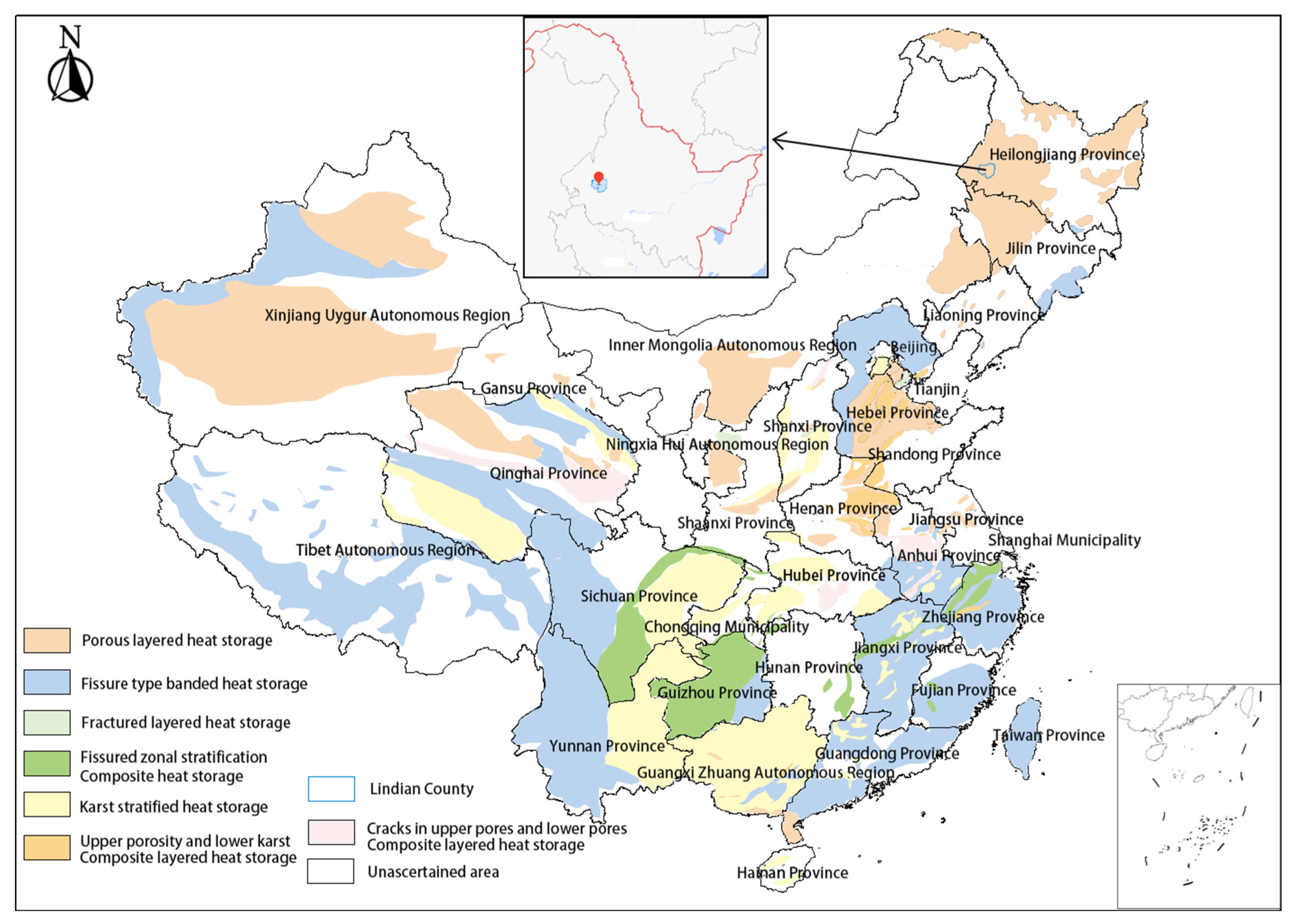
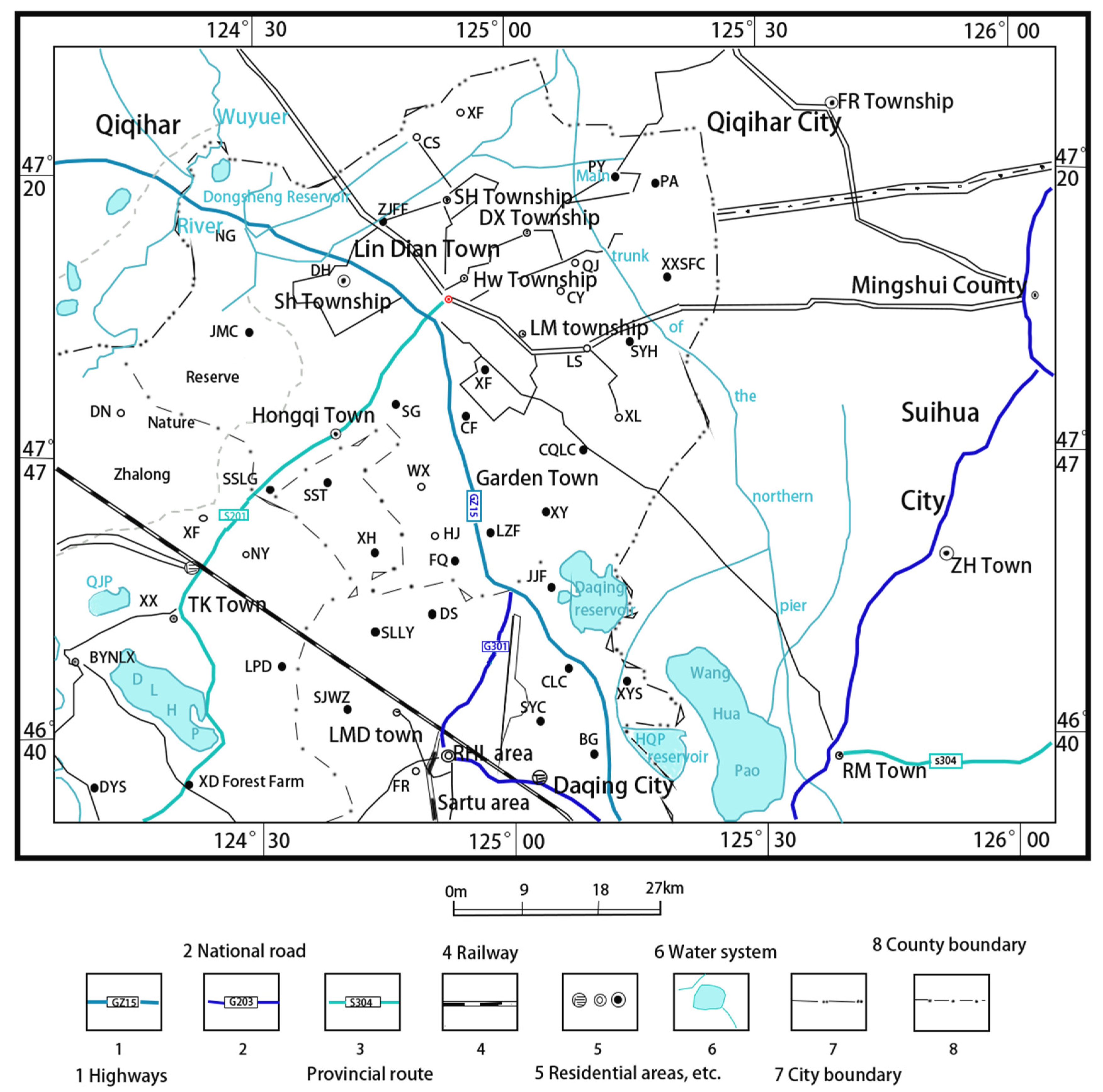
2.1. Study Area
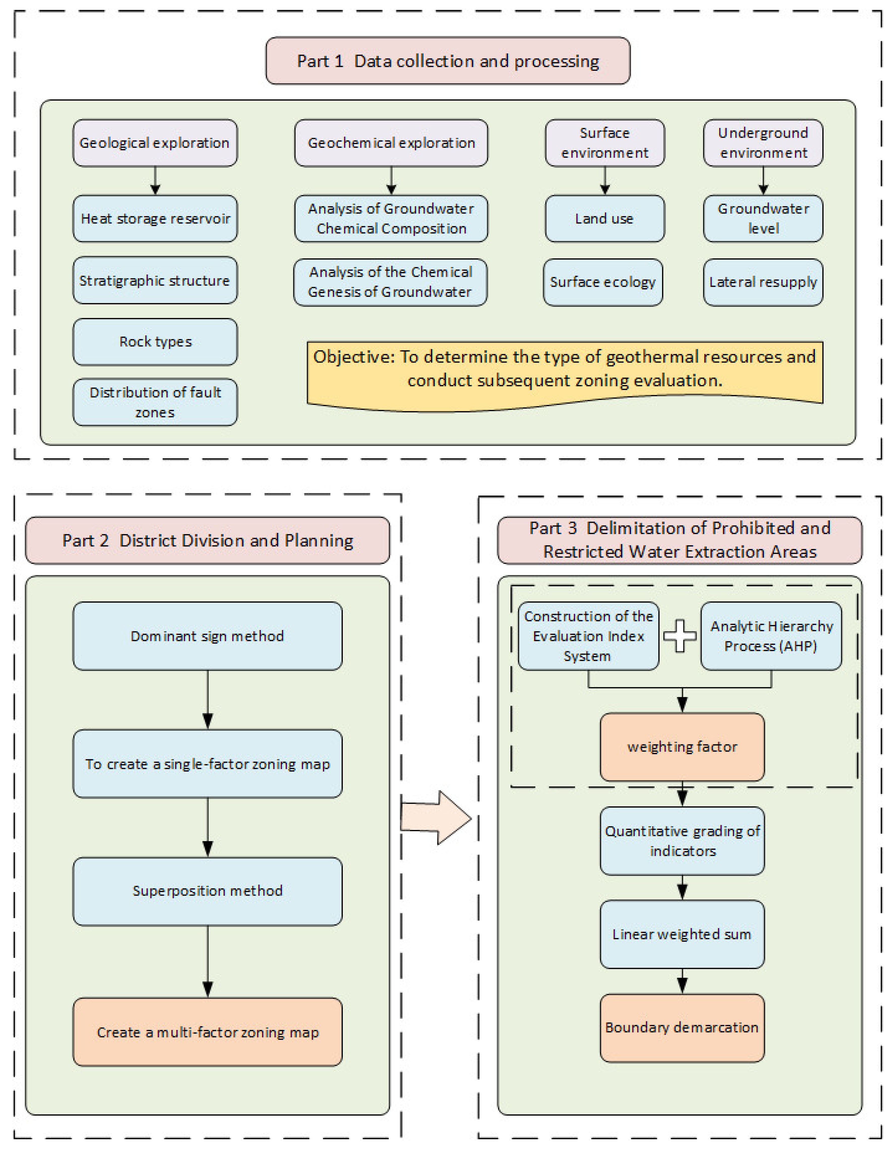
2.2. Research Methods
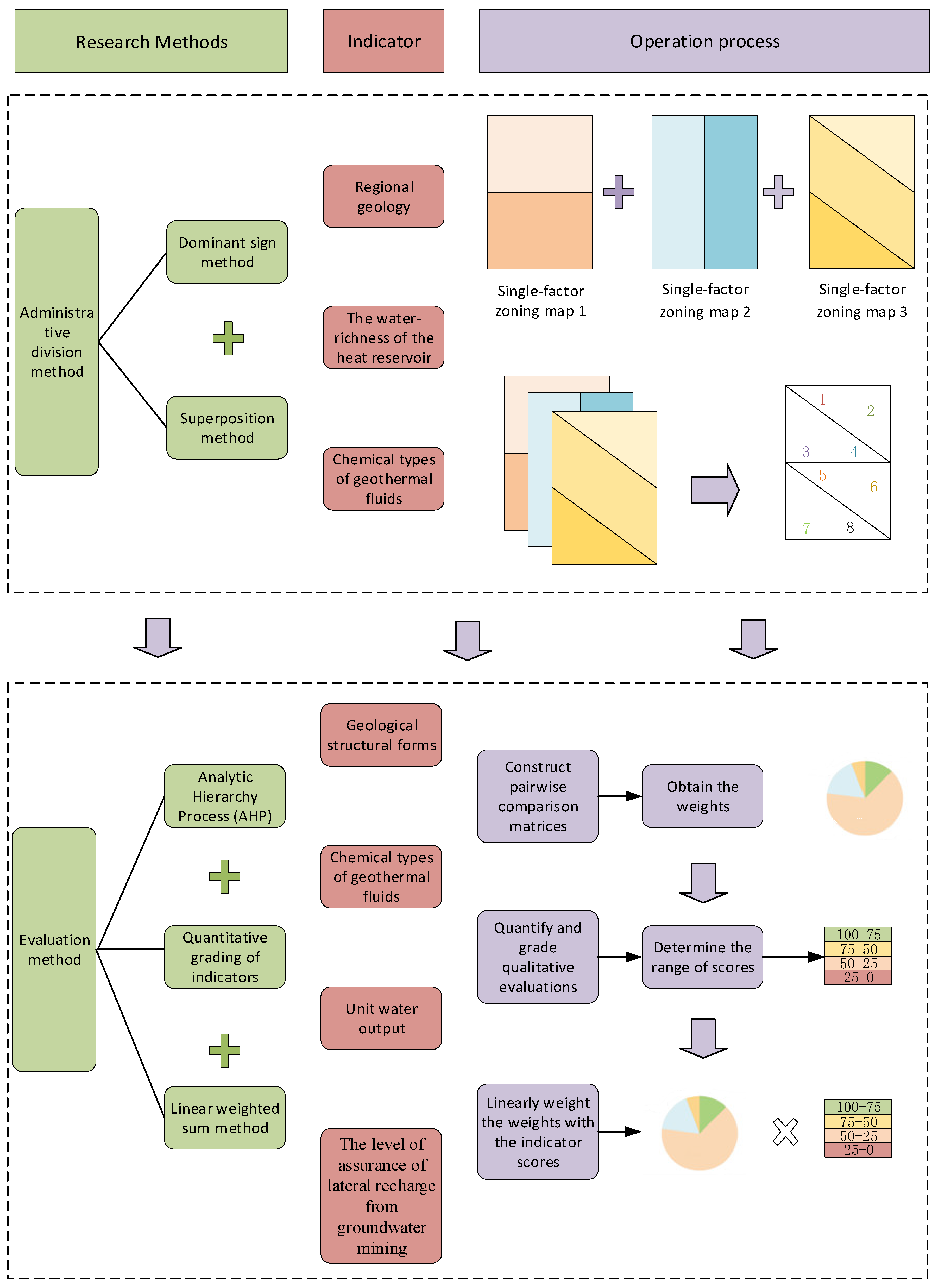
2.2.1. Study Area Zoning Method
2.2.2. Evaluation Method for Suitability of the Study Area
3. Results
3.1. Partition
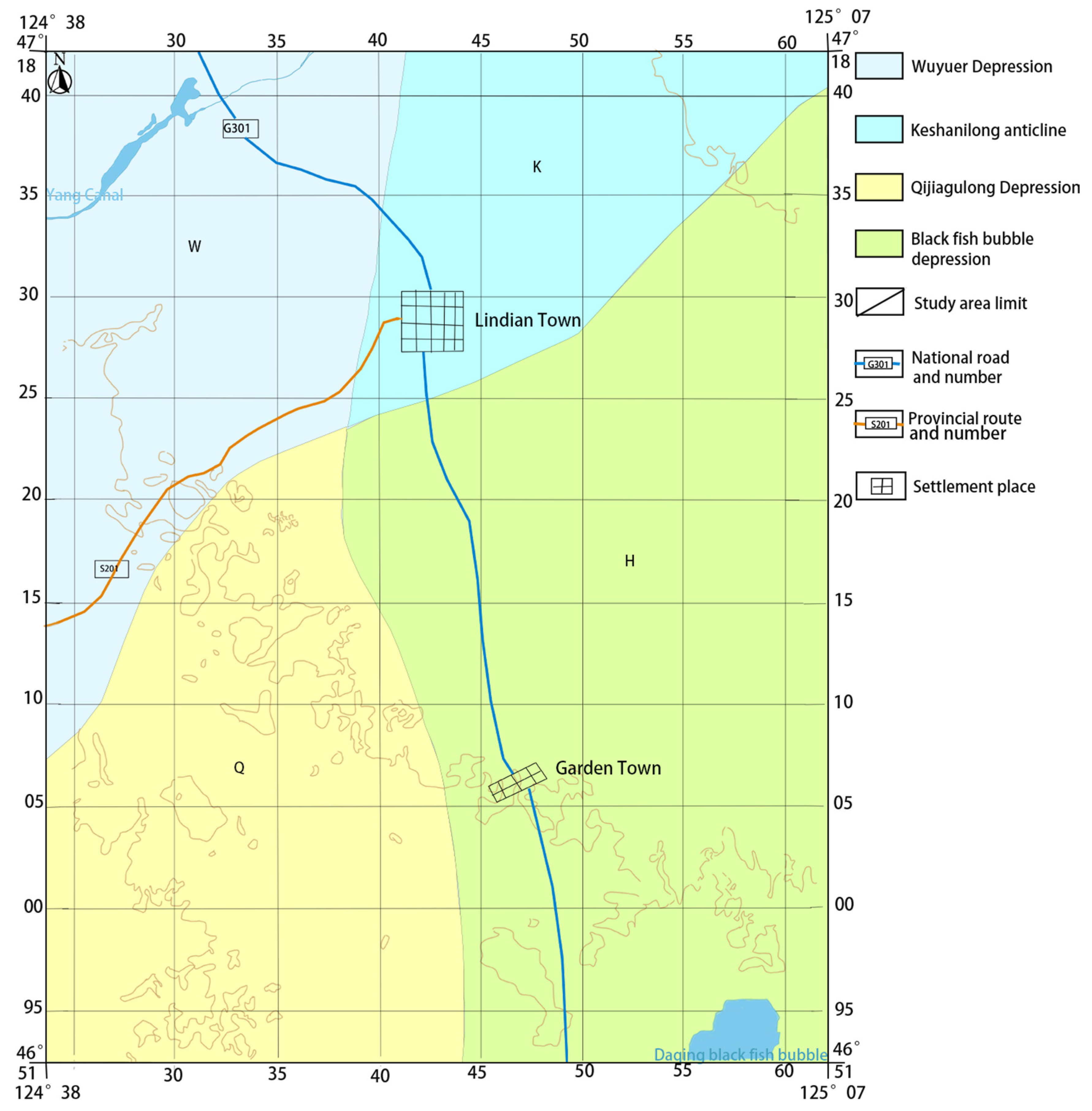
3.1.1. Regional Geological Single-Factor Zoning
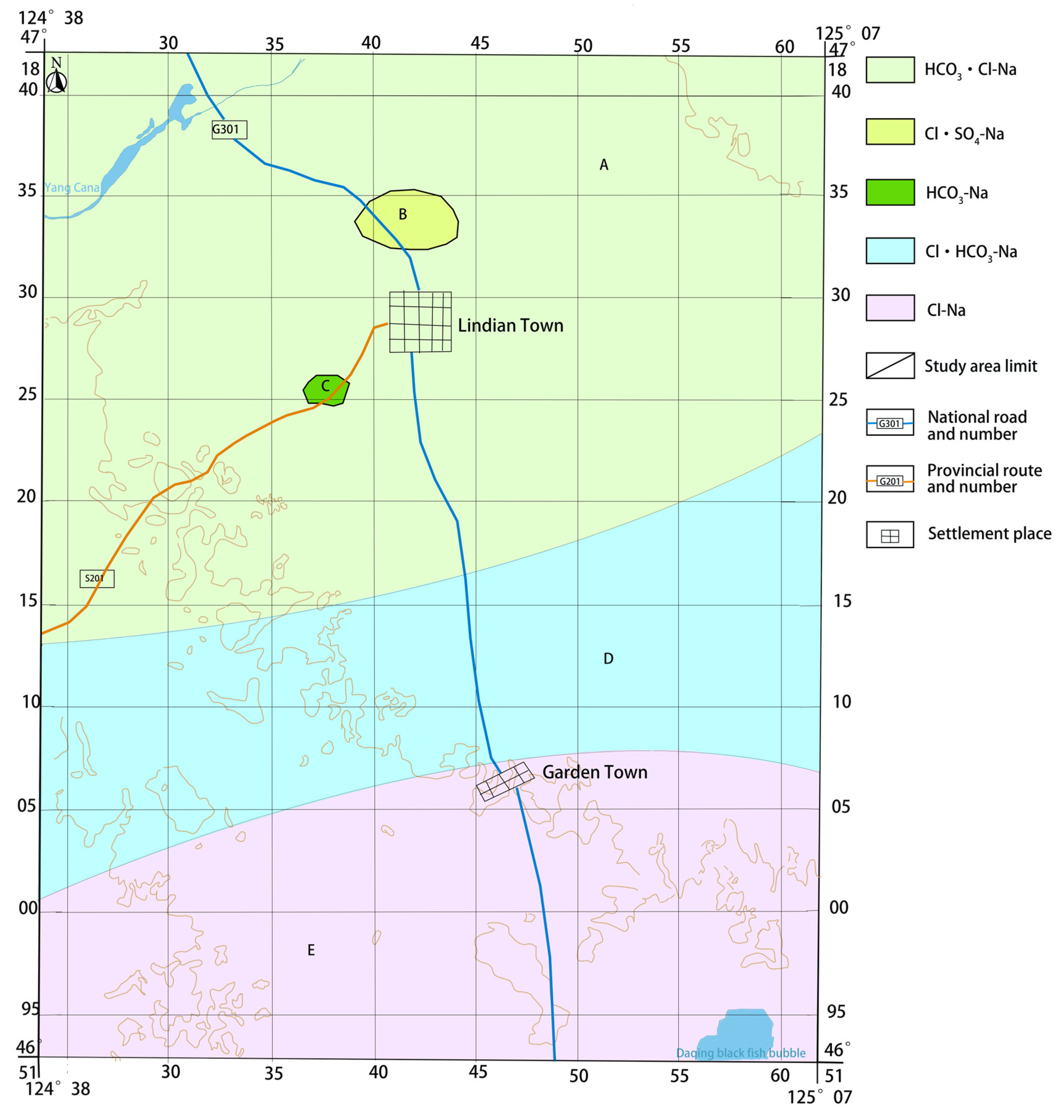
3.1.2. Single-Factor Regionalization of Hydrochemical Types of Geothermal Fluids
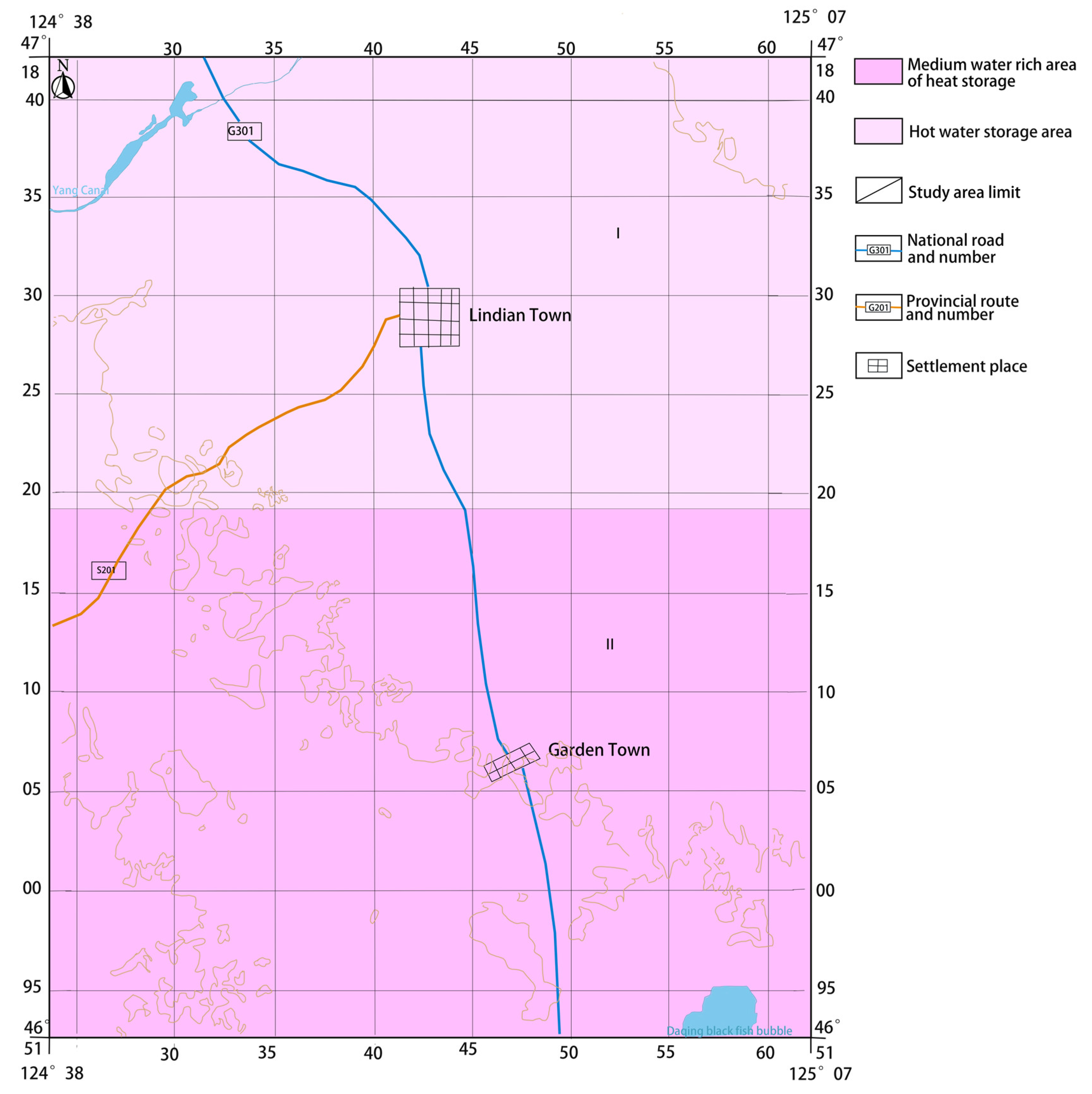
3.1.3. Single-Factor Zoning of Geothermal Reservoir Water-Richness
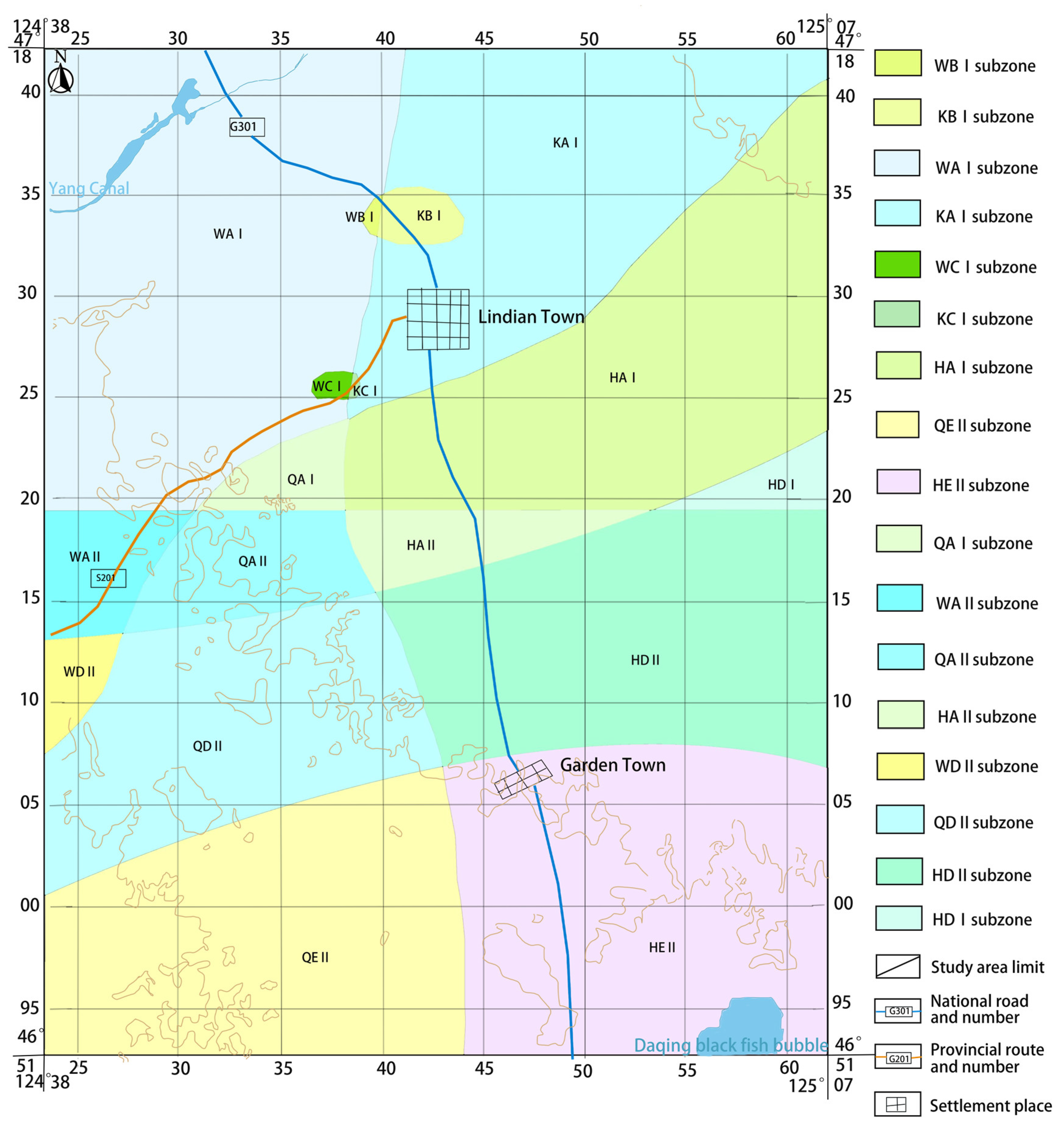
3.1.4. Three-Factor Coupling Zoning by Superposition Method
3.2. Evaluation Results of Suitability
3.2.1. Calculation of Indicator Weights
3.2.2. Quantitative Grading of Indicators
3.2.3. Comprehensive Score of Suitability Evaluation
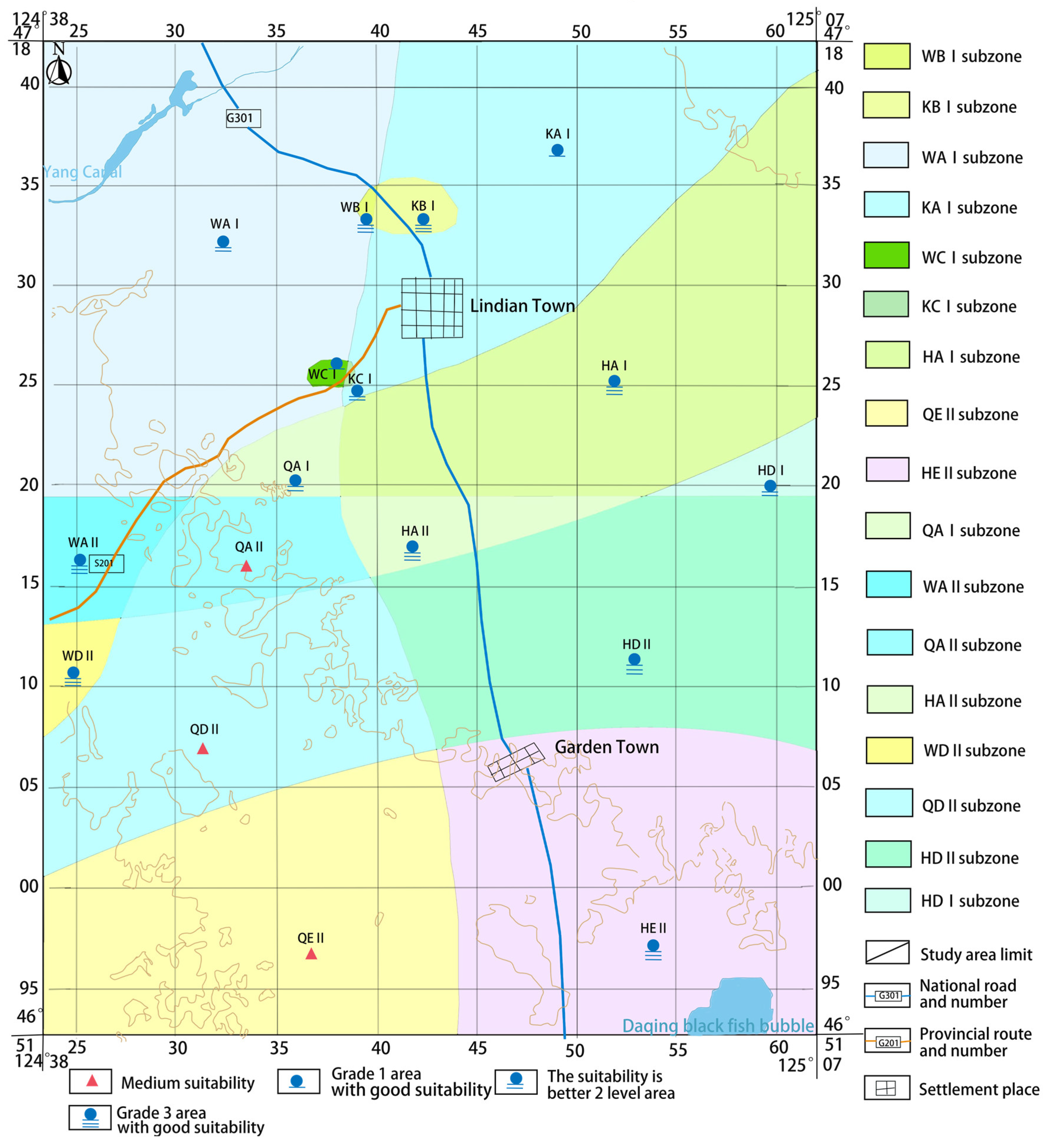
3.3. Grading and Zoning of Water Suitability
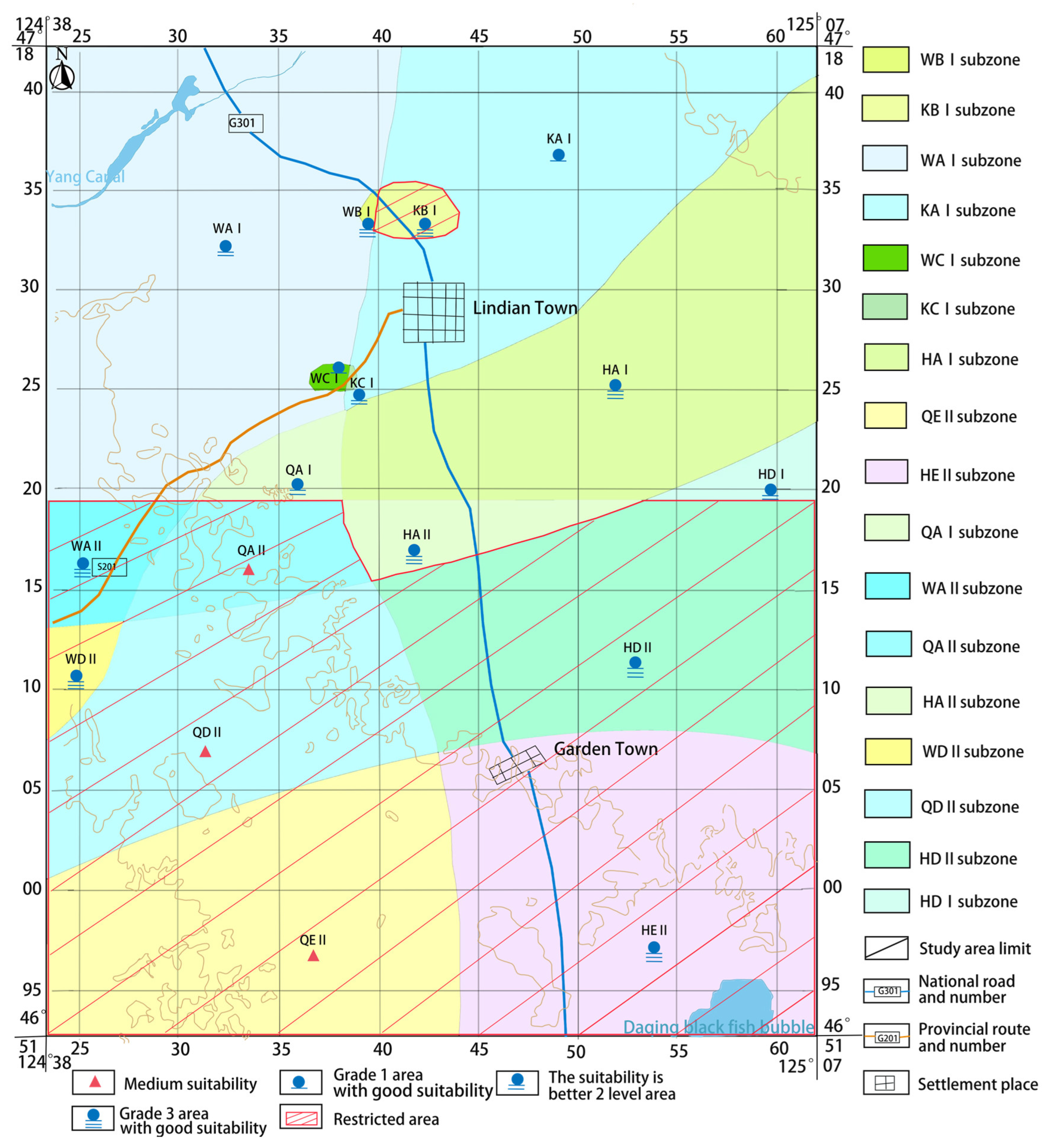
3.4. The Delineation of Areas Where Water Extraction Is Prohibited or Restricted
4. Discussion
4.1. Summary of Results
4.2. Extension and Outlook
5. Conclusions
- (1)
- Using the dominant sign method combined with the superposition method for the zoning of the study area, through the dominant sign method comprehensive analysis to determine the regional geological, hydrochemistry types of geothermal fluid, and geothermal reservoir water-richness nature of the zoning indicators, firstly, according to the zoning indicators of the single-factor zoning, and then through spatial superposition of the formation of the three-factor coupling zoning results. Lindian County is divided into 17 sub-regions, each with a different set of factors, so the impacts of prohibiting and restricting water withdrawals for geothermal energy development and utilization projects are also quite different.
- (2)
- Based on the principles of dominance, wide coverage, and measurability, the geological formations, hydrochemical types of geothermal fluids, water output per unit, and the degree of guarantee for the lateral recharge volume during mining were selected as the suitability evaluation indexes. Hierarchical analysis was used to find the weights of evaluation indexes, and the evaluation indexes were quantified and graded. Finally, the final scores of each sub-district were obtained through linear weighting and summing. The results show that the water extraction conditions for the development and utilization of geothermal energy in Lindian County are generally better, with 3 out of 17 subzones having moderate suitability and 14 subzones having good suitability, among which WC I and KA I subzones are the most suitable for water extraction, and they have better advantages in terms of the potential of groundwater resources, the difficulty of extraction, and the type of water extraction, while the relative suitability for water extraction in QE II, QD II, and QA II subzones is weaker.
- (3)
- The 14 appropriate subareas are separated into 2 better appropriate level 1 zones, 4 better appropriate level 2 zones, and 8 better appropriate level 3 zones based on the water-richness of the geothermal reservoir, geothermal resource storage, lateral recharge, hydrochemistry types of geothermal fluid, and mining difficulties of each subarea. Meanwhile, through comparative analysis, the eight districts with a comprehensive score of 55 points or less were designated as restricted water extraction areas. These areas must strictly regulate the amount of water extracted and implement sustainable development and geothermal energy utilization reasonably and effectively. In addition to optimizing the architecture of geothermal resource development, such delineation can effectively govern the ecological environment and geothermal resources. It is also crucial for the high-quality development and usage of geothermal energy.
Author Contributions
Funding
Institutional Review Board Statement
Informed Consent Statement
Data Availability Statement
Acknowledgments
Conflicts of Interest
References
- Cui, R.G.; Guo, J.; Cheng, L.H.; Zhang, Y.X.; Liu, W. Status and trends analysis of global clean energies. Acta Geosci. Sin. 2021, 42, 179–186. [Google Scholar]
- Gustafsson, R.; Dutta, A.; Bouri, E. Are energy metals hedges or safe havens for clean energy stock returns? Energy 2022, 244, 122708. [Google Scholar] [CrossRef]
- Dincer, I.; Acar, C. A review on clean energy solutions for better sustainability. Int. J. Energy Res. 2015, 39, 585–606. [Google Scholar] [CrossRef]
- Ding, Y.T. Make Geothermal Energy “Hot”. People’s Daily, 18 October 2023, 018. Available online: https://paper.people.com.cn/rmrb/html/2023-10/18/nw.D110000renmrb_20231018_4-18.htm (accessed on 14 May 2025). (In Chinese).
- Ma, W.; Gong, Y.; Zhao, D.; Xu, Q.; Qin, H.; Chen, Y. Geothermal Energy Exploitation, Utilization, and Its Development Trend in China. Bull. Chin. Acad. Sci. 2016, 31, 199–207. (In Chinese) [Google Scholar]
- Kumar, L.; Hossain, M.S.; Assad, M.E.H.; Manoo, M.U. Technological Advancements and Challenges of Geothermal Energy Systems: A Comprehensive Review. Energies 2022, 15, 9058. [Google Scholar] [CrossRef]
- Sang, Z.; Zhang, G.; Wang, H.; Zhang, W.; Chen, Y.; Han, M.; Yang, K. Effective Solutions to Ecological and Water Environment Problems in the Sanjiang Plain: Utilization of Farmland Drainage Resources. Sustainability 2023, 15, 16329. [Google Scholar] [CrossRef]
- Ren, Y.; Lu, X.; Zhang, W.; Zhang, J.; Liu, J.; Ma, F.; Cui, Z.; Yu, H.; Zhu, T.; Zhang, Y. Preliminary Study on Optimization of a Geothermal Heating System Coupled with Energy Storage for Office Building Heating in North China. Energies 2022, 15, 8947. [Google Scholar] [CrossRef]
- Cui, Y.J. The Current Situation and Development Suggestions of Geothermal Resources Development and Utilization in China. Sci. Technol. Econ. Inn. Mong. 2022, 22, 90–91. (In Chinese) [Google Scholar]
- Ma, L. New technologies and new business models in geothermal energy keep emerging continuously. China Petrochemical News, 30 December 2024. [Google Scholar]
- Shortall, R.; Davidsdottir, B.; Axelsson, G. Geothermal energy for sustainable development: A review of sustainability impacts and assessment frameworks. Renew. Sustain. Energy Rev. 2015, 44, 391–406. [Google Scholar] [CrossRef]
- Sharmin, T.; Khan, N.R.; Akram, M.S.; Ehsan, M.M. A state-of-the-art review on geothermal energy extraction, utilization, and improvement strategies: Conventional, hybridized, and enhanced geothermal systems. Int. J. Thermofluids 2023, 18, 100323. [Google Scholar] [CrossRef]
- Stober, I.; Bucher, K. Uses of Geothermal Energy. In Geothermal Energy: From Theoretical Models to Exploration and Development; Springer International Publishing: Cham, Switzerland, 2021; pp. 43–79. [Google Scholar]
- Xu, Z.; Zhao, H.; Fan, L.; Jia, Q.; Zhang, T.; Zhang, X.; Han, D.; Tan, Y.; Liu, J. A literature review of using supercritical CO2 for geothermal energy extraction: Potential, methods, challenges, and perspectives. Renew. Energy Focus 2024, 51, 100637. [Google Scholar] [CrossRef]
- Wang, G.L.; Wang, W.L.; Zhang, W.; Ma, F.; Liu, F. The status quo and prospect of geothermal resources exploration and development in Bei**g-Tianj in-Hebei region in China. China Geol. 2020, 3, 173–181. [Google Scholar] [CrossRef]
- Zhengmeng, H.O.; Xuning, W.U.; Jiashun, L.U.; Liehui, Z.H.; Zaoyuan, L.I.; Cheng, C.A.; Lin, W.U.; Qianjun, C.H. Major challenges of deep geothermal systems and an innovative development mode of REGS integrated with energy storage. Coal Geol. Explor. 2024, 52, 1–3. [Google Scholar]
- Wang, G.L.; Zhang, W.; Ma, F.; Lin, W.J.; Liang, J.Y.; Zhu, X. Overview on hydrothermal and hot dry rock researches in China. China Geol. 2018, 1, 273–285. [Google Scholar] [CrossRef]
- Li, W.; Kong, X.J.; Yuan, L.J.; Gao, J.; Shen, T.F.; Feng, H.; Hao, W.; He, Y. Overview of Geothermal Resources in China and Suggestions for Their Development and Utilization. China’s Min. Ind. 2020, 29 (Suppl. 1), 22–26. [Google Scholar]
- Guo, X.; Dang, L.; Han, Z.; Guo, D. High-quality development of China’s geothermal industry—China National Report of the 2023 world geothermal conference. In Proceedings of the World Geothermal Congress 2023, Beijing, China, 15–17 September 2023; pp. 15–17. [Google Scholar]
- Zhang, J.C.; Chen, L.; Sun, Y.H.; Xu, L.F.; Zhao, X.X.; Li, Q.C.; Zhang, D. Geothermal resource distribution and prospects for development and utilization in China. Nat. Gas Ind. B 2024, 11, 6–18. [Google Scholar] [CrossRef]
- Xia, Z.H.; Jia, G.S.; Ma, Z.D.; Wang, J.W.; Zhang, Y.P.; Jin, L.W. Analysis of economy, thermal efficiency and environmental impact of geothermal heating system based on life cycle assessments. Appl. Energy 2021, 303, 117671. [Google Scholar] [CrossRef]
- Jia, Y.Y.; Chang, Q.; Wang, Y.W.; Yao, P.Y.; Yu, K.F. The current situation of geothermal energy development and utilization in China and its development trend under the background of carbon neutrality. Green Pet. Petrochem. 2021, 6, 5–9. (In Chinese) [Google Scholar]
- Wang, G.L.; Zhang, W.; Liang, J.Y.; Lin, W.J.; Liu, Z.M.; Wang, W.L. Evaluation of Geothermal Resources Potential in China. Acta Geol. Sin. 2017, 38, 449–450. (In Chinese) [Google Scholar]
- Pasqualetti, M.J. The site specific nature of geothermal energy: The primary role of land use planning in nonelectric development. Nat. Resour. J. 1983, 23, 795–814. [Google Scholar]
- He, L.; Yang, L.; Lei, S.; Xu, C.; Chen, L. Comprehensive Evaluation of Adaptability Zoning for Shallow Geothermal Energy Development and Utilization: Case of Nantong City, East Coast of China. Int. J. Energy Res. 2024, 2024, 6648349. [Google Scholar] [CrossRef]
- Liu, J.L.; Han, S.B.; Xiang, H.; Yue, D.D.; Yang, F.T. The resource potential and zoning evaluation for deep geothermal resources of the Dongying formation in TianJin Binhai new area. Sustainability 2023, 15, 12357. [Google Scholar] [CrossRef]
- Unternährer, J.; Moret, S.; Joost, S.; Maréchal, F. Spatial clustering for district heating integration in urban energy systems: Application to geothermal energy. Appl. Energy 2017, 190, 749–763. [Google Scholar] [CrossRef]
- Mahdy, M.; Bahaj, A.S. Multi-criteria decision analysis for offshore wind energy potential in Egypt. Renew. Energy 2018, 118, 278–289. [Google Scholar] [CrossRef]
- Saraswat, S.K.; Digalwar, A.K. Evaluation of energy alternatives for sustainable development of energy sector in India: An integrated Shannon’s entropy fuzzy multi-criteria decision approach. Renew. Energy 2021, 171, 58–74. [Google Scholar] [CrossRef]
- Fang, H.; Wang, X.; Song, W. Technology selection for photovoltaic cell from sustainability perspective: An integrated approach. Renew. Energy 2020, 153, 1029–1041. [Google Scholar] [CrossRef]
- Qian, J.; Wu, J.; Yao, L.; Mahmut, S.; Zhang, Q. Comprehensive performance evaluation of Wind-Solar-CCHP system based on emergy analysis and multi-objective decision method. Energy 2021, 230, 120779. [Google Scholar] [CrossRef]
- Xu, F.G.; Li, L.X. Prospects for Exploration and Development of Geothermal Resources in Lin Deng County. In A Collection of Papers on the Strategic Research on the Development of Geothermal Resources in Western China; 2001; pp. 77–82. Available online: https://cpfd.cnki.com.cn/Article/CPFDTOTAL-IGNH200107001011.htm (accessed on 14 May 2025). (In Chinese)
- Xu, S.Q.; Liang, X.H.; Song, L. Study and Analysis on Groundwater Dynamics in Lin Deng County. Heilongjiang Water Conserv. Sci. Technol. 2010, 185–186. (In Chinese) [Google Scholar] [CrossRef]
- Jia, C.; Dong, X.; Ding, P.P.; Feng, K.Y.; Wang, H.; Wang, M.Z. Experimental Study on Thermal Consolidation Deformation Characteristics of Pore-type Geothermal Reservoirs. Geotech. Mech. 2023, 44 (Suppl. 1), 91–98. (In Chinese) [Google Scholar]
- Ahadi, P.; Fakhrabadi, F.; Pourshaghaghy, A.; Kowsary, F. Optimal site selection for a solar power plant in Iran via the Analytic Hierarchy Process (AHP). Renew. Energy 2023, 215, 118944. [Google Scholar] [CrossRef]
- Shahnazari, A.; Pourdej, H.; Kharage, M.D. Ranking of organic fertilizer production from solid municipal waste systems using analytic hierarchy process (AHP) and VIKOR models. Biocatal. Agric. Biotechnol. 2021, 32, 101946. [Google Scholar] [CrossRef]
- Alam, E.; Ray-Bennett, N.S. Disaster risk governance for district-level landslide risk management in Bangladesh. Int. J. Disaster Risk Reduct. 2021, 59, 102220. [Google Scholar] [CrossRef]
- Yanbo, Q.; Shilei, W.; Yaya, T.; Guanghui, J.; Tao, Z.; Liang, M. Territorial spatial planning for regional high-quality development–An analytical framework for the identification, mediation and transmission of potential land utilization conflicts in the Yellow River Delta. Land Use Policy 2023, 125, 106462. [Google Scholar] [CrossRef]
- Xie, G.D.; Zhang, C.S.; Zhang, L.B.; Su, D.; Cao, S.Y.; Leng, Y.F.; Xiao, Y. China’s county-scale ecological regionalization. J. Nat. Resour. 2012, 27, 154–162. [Google Scholar]
- Huang, J.J.; Gan, Y.Q.; Miao, S.X.; Wu, J.Q.; Yang, L.; Hua, M.; Min, W.; Zhao, L.; Fang, Q. A preliminary study of the evaluation index system for geo-environment regionalization in Jiangsu. Geol. China 2011, 38, 1599–1606. [Google Scholar]
- Wang, N.; Cheng, W.; Wang, B.; Liu, Q.; Zhou, C. Geomorphological regionalization theory system and division methodology of China. J. Geogr. Sci. 2020, 30, 212–232. [Google Scholar] [CrossRef]
- Chen, Y.; Zhang, D. Evaluation and driving factors of city sustainability in Northeast China: An analysis based on interaction among multiple indicators. Sustain. Cities Soc. 2021, 67, 102721. [Google Scholar] [CrossRef]
- Li, J.; Gallego-Schmid, A.; Stamford, L. Integrated sustainability assessment of repurposing onshore abandoned wells for geothermal power generation. Appl. Energy 2024, 359, 122670. [Google Scholar] [CrossRef]
- Ramos-Escudero, A.; García-Cascales, M.S.; Cuevas, J.M.; Sanner, B.; Urchueguía, J.F. Spatial analysis of indicators affecting the exploitation of shallow geothermal energy at European scale. Renew. Energy 2021, 167, 266–281. [Google Scholar] [CrossRef]
- Saaty, T.L. Decision-making with the analytic hierarchy process. Int. J. Serv. Sci. 2008, 1, 83–98. [Google Scholar] [CrossRef]
- Li, P.; Wang, B.; Chen, P.; Zhang, Y.; Zhao, S. Vulnerability assessment of the eco-geo-environment of mining cities in arid and semi-arid areas: A case study from Zhungeer, China. Ecol. Indic. 2023, 152, 110364. [Google Scholar] [CrossRef]
- Dong, J.; He, P.; Liu, H.; Guan, Y.; Liu, H.; Xia, W.Q.; Dong, J. AHP-Based Evaluation of the Suitability of Shallow Geothermal Energy Utilization in GSHP System. Front. Energy Res. 2022, 10, 859454. [Google Scholar] [CrossRef]
- Tang, F.; Wang, L.; Guo, Y.; Fu, M.; Huang, N.; Duan, W.; Luo, M.; Zhang, J.; Li, W.; Song, W. Spatio-temporal variation and coupling coordination relationship between urbanisation and habitat quality in the Grand Canal, China. Land Use Policy 2022, 117, 106119. [Google Scholar] [CrossRef]
- Cai, W.; Zhai, B.; Liu, Y.; Liu, R.; Ning, X. Quadratic polynomial guided fuzzy C-means and dual attention mechanism for medical image segmentation. Displays 2021, 70, 102106. [Google Scholar] [CrossRef]
- Glukhova, S.A.; Sukhanova, T.V.; Pinigin, O.V.; Kharitonova, N.A. Hydrogeological Conditions of the Meshchera Depression and Their Connection with the Latest Tectonic Structure of the Region. Mosc. Univ. Geol. Bull. 2024, 79, 586–595. [Google Scholar] [CrossRef]
- Behzad, H.M.; Ford, D.; Nie, Y.; Peng, T.; Keshavarzi, M.; Zhang, J.; Wang, F.; Chen, H.; Vardanjani, H.K. Illuminating the complexity of hydrogeological regimes in fault-influenced, anticlinal karst aquifers: Insights into the recharge patterns in tectonically complex karst catchments. J. Hydrol. 2023, 626, 130247. [Google Scholar] [CrossRef]
- Erbaş, H.A.; Bozdağ, A. Hydrogeochemical characteristics and evaluation of the geothermal fluids in the Gazlıgöl geothermal field (Afyonkarahisar), Western Anatolia, Turkey. Geothermics 2022, 105, 102543. [Google Scholar] [CrossRef]
- Wang, X.; Yuan, X.; Shui, Q.; Qi, Y.; Deng, X.; Yang, F. Optimized allocation of water temperature, quality, and quantity for the utilization of geothermal water from deep buried reservoirs. Geothermics 2024, 119, 102951. [Google Scholar] [CrossRef]
- Song, X.; Li, G.; Huang, Z.; Shi, Y.; Wang, G.; Song, G.; Xu, F. Review of high-temperature geothermal drilling and exploitation technologies. Gondwana Res. 2023, 122, 315–330. [Google Scholar] [CrossRef]
- Zhang, C.; Huang, R.; Qin, S.; Hu, S.; Zhang, S.; Li, S.; Zhang, L.; Wang, Z. The high-temperature geothermal resources in the Gonghe-Guide area, northeast Tibetan plateau: A comprehensive review. Geothermics 2021, 97, 102264. [Google Scholar] [CrossRef]
- Zhang, G.; Zhu, J.; Yang, K.; Zhu, Y.; Sang, Z. Design of an Enhanced SAT Using Zeolite for the Removal of Ammonia Nitrogen at a Bengbu Aquatic Farm in China. Sustainability 2022, 14, 16983. [Google Scholar] [CrossRef]

| Suitability | Score Range | General Situation of the Interval |
|---|---|---|
| High suitability | 100 ≥ Y ≥ 75 | There is a full-year water withdrawal plan to ensure the sustainable development of groundwater resources; geothermal resources are plentiful, reserves are adequate, environmental conditions satisfy development needs, and the lateral recharge of exploitation is significantly larger than the exploitable reserves. |
| Good suitability | 75 > Y ≥ 50 | To sustainably protect groundwater resources, a full year of water withdrawal planning is required, along with the mining of lateral recharge and recoverable reserves, rich geothermal resources, adequate reserves, and environmental circumstances that essentially fulfill development needs. |
| Moderate suitability | 50 > Y ≥ 25 | Although the region’s geothermal resources are comparatively abundant and have enough reserves, development is challenging, lateral recharge extraction is less than recoverable reserves, and appropriate recharge is needed. To guarantee sustainable groundwater resources, a complete year of water withdrawal planning is done concurrently. |
| Poor suitability | 25 > Y ≥ 0 | Geothermal resources are hard to develop and yield poor results; they are also relatively limited and do not meet the requirements for the development of geothermal energy and water usage. |
| Number | Zone Name |
|---|---|
| W | Wuyuer Depression |
| K | Keshan–Yilong Anticline |
| Q | Qijia–Gulong Depression |
| H | Black Fish Bubble Depression |
| Number | Zone Name |
|---|---|
| A | HCO3·Cl-Na type |
| B | Cl·SO4-Na type |
| C | HCO3-Na type |
| D | Cl·HCO3-Na type |
| E | Cl-Na type |
| Number | Zone Name |
|---|---|
| Ⅰ | Rich water-bearing zone of the geothermal reservoir |
| Ⅱ | Moderately water-rich zone in the heat reservoir |
| Geological Conditions | Water Resource Conditions | Environmental Impact | |
|---|---|---|---|
| Geological conditions | 1 | 1/3 | 2 |
| Water resource conditions | 3 | 1 | 5 |
| Environmental impact | 1/2 | 1/5 | 1 |
| Geological Structural Forms | Chemical Types of Geothermal Fluids | |
|---|---|---|
| Geological structural forms | 1 | 1/3 |
| Chemical types of geothermal fluids | 3 | 1 |
| Target Layer | Criterion Layer | Weighting Factor | Indicator Layer | Weighting Factor | Weight of Individual Indicators |
|---|---|---|---|---|---|
| The delineation of areas where water extraction is prohibited or restricted | Geological conditions | 0.2299 | Geological structural forms | 0.25 | 0.0575 |
| Chemical types of geothermal fluids | 0.75 | 0.1724 | |||
| Water resource conditions | 0.6480 | Unit water output | 1 | 0.6480 | |
| Environmental impact | 0.1221 | The degree of guarantee for the lateral recharge volume during mining | 1 | 0.1221 |
| Criterion Layer | Indicator Layer | Weightage | Evaluation Criteria | |||
|---|---|---|---|---|---|---|
| High Suitability (100 ≥ F ≥ 75) | Good Suitability (75 > F ≥ 50) | Moderate Suitability (50 > F ≥ 25) | Poor Suitability (25 > F ≥ 0) | |||
| Geological conditions | Geological structural forms | 0.0575 | Fault; Magma intrusion body | Depression; joint; fissure | Anticline; the direction of bedding is consistent with the direction of groundwater flow. | Close folds; gentle bedding of rock strata |
| Chemical types of geothermal fluids | 0.1724 | HCO3-Na type | HCO3·Cl-Na, Cl·HCO3-Na type | Cl·SO4-Na, Cl-Na type | High-sulfur water; water containing heavy metals and harmful chemicals; hard water | |
| Water resource conditions | Unit water output | 0.6480 | Unit water output > 1.0 L/(s·m) | 0.5 L/(s·m) < Unit water output < 1.0 L/(s·m) | 0.1 L/(s·m) < Unit water output < 0.5 L/(s·m) | Unit water output < 0.1 L/(s·m) |
| Environmental impact | The degree of guarantee for the lateral recharge volume during mining | 0.1221 | The lateral recharge volume is far greater than the exploitable reserves of geothermal water. | The lateral recharge volume extracted is equal to the exploitable reserves of geothermal water. | The lateral recharge volume available for exploitation is slightly less than the exploitable reserves of geothermal water. | The lateral recharge volume that can be exploited is far less than the exploitable reserves of geothermal water. |
| Zone Name | Suitability | Score |
|---|---|---|
| WB I Zone | Good suitability | 56.33 |
| KB I Zone | Good suitability | 54.30 |
| WA I Zone | Good suitability | 65.80 |
| KA I Zone | Good suitability | 70.86 |
| WC I Zone | Good suitability | 72.56 |
| KC I Zone | Good suitability | 65.81 |
| HA I Zone | Good suitability | 58.23 |
| QE II Zone | Moderate suitability | 43.01 |
| HE II Zone | Good suitability | 51.24 |
| QA I Zone | Good suitability | 65.24 |
| WA II Zone | Good suitability | 52.15 |
| QA II Zone | Moderate suitability | 49.11 |
| HA II Zone | Good suitability | 55.17 |
| WD II Zone | Good suitability | 51.99 |
| QD II Zone | Moderate suitability | 46.51 |
| HD II Zone | Good suitability | 50.85 |
| HD I Zone | Good suitability | 61.23 |
| Zone Name | Suitability Results |
|---|---|
| WB I Zone | Suitable areas |
| KB I Zone | Restricted areas |
| WA I Zone | Suitable areas |
| KA I Zone | Suitable areas |
| WC I Zone | Suitable areas |
| KC I Zone | Suitable areas |
| HA I Zone | Suitable areas |
| QE II Zone | Restricted areas |
| HE II Zone | Restricted areas |
| QA I Zone | Suitable areas |
| WA II Zone | Restricted areas |
| QA II Zone | Restricted areas |
| HA II Zone | Suitable areas |
| WD II Zone | Restricted areas |
| QD II Zone | Restricted areas |
| HD II Zone | Restricted areas |
| HD I Zone | Suitable areas |
Disclaimer/Publisher’s Note: The statements, opinions and data contained in all publications are solely those of the individual author(s) and contributor(s) and not of MDPI and/or the editor(s). MDPI and/or the editor(s) disclaim responsibility for any injury to people or property resulting from any ideas, methods, instructions or products referred to in the content. |
© 2025 by the authors. Licensee MDPI, Basel, Switzerland. This article is an open access article distributed under the terms and conditions of the Creative Commons Attribution (CC BY) license (https://creativecommons.org/licenses/by/4.0/).
Share and Cite
Tian, Y.; Meng, L.; Sang, Z.; Chen, Y.; Yan, F.; Zhang, G. Defining the Range of Water Withdrawals That Are Forbidden and Regulated for Geothermal Energy Development and Use Projects: A Case Study of Lindian County, Northeast China. Sustainability 2025, 17, 4609. https://doi.org/10.3390/su17104609
Tian Y, Meng L, Sang Z, Chen Y, Yan F, Zhang G. Defining the Range of Water Withdrawals That Are Forbidden and Regulated for Geothermal Energy Development and Use Projects: A Case Study of Lindian County, Northeast China. Sustainability. 2025; 17(10):4609. https://doi.org/10.3390/su17104609
Chicago/Turabian StyleTian, Ye, Lizhi Meng, Zijie Sang, Yuxiu Chen, Feiyang Yan, and Ge Zhang. 2025. "Defining the Range of Water Withdrawals That Are Forbidden and Regulated for Geothermal Energy Development and Use Projects: A Case Study of Lindian County, Northeast China" Sustainability 17, no. 10: 4609. https://doi.org/10.3390/su17104609
APA StyleTian, Y., Meng, L., Sang, Z., Chen, Y., Yan, F., & Zhang, G. (2025). Defining the Range of Water Withdrawals That Are Forbidden and Regulated for Geothermal Energy Development and Use Projects: A Case Study of Lindian County, Northeast China. Sustainability, 17(10), 4609. https://doi.org/10.3390/su17104609