Article

Land Cover and Wildfire Risk: A Multi-Buffer Spatial Analysis of the Relationship Between Housing Destruction and Land Cover in Chile’s Bío-Bío Region in 2023

by
Benedikt Hora
1,2,3,*,
Constanza González-Mathiesen
2,4,
Natalia Aravena-Solís
5 and
Tomás Tapia
6
1
Escuela de Agronomía, Universidad Mayor, Temuco 4780000, Chile
2
Research Center for Integrated Disaster Risk Management (CIGIDEN) ANID/FONDAP 2023/1523A0009, Santiago de Chile 7820436, Chile
3
Centro para la Resiliencia, Adaptación y Mitigación (CReAM), Universidad Mayor, Temuco 4780000, Chile
4
Facultad de Arquitectura y Arte, Universidad del Desarrollo, Concepción 4070386, Chile
5
Programa de Doctorado en Geografía, Instituto de Geografía, Facultad de Historia, Geografía y Ciencia Política, Pontificia Universidad Católica de Chile, Santiago 7820436, Chile
6
Laboratorio de Estudios Territoriales (LabT-UACh), Universidad Austral de Chile, Valdivia 5090000, Chile
*
Author to whom correspondence should be addressed.
Sustainability 2025, 17(10), 4416; https://doi.org/10.3390/su17104416
Submission received: 10 March 2025 / Revised: 26 April 2025 / Accepted: 26 April 2025 / Published: 13 May 2025
(This article belongs to the Special Issue Land Use Strategies for Sustainable Development)

Abstract

:
Wildfires pose increasing risks to human settlements, particularly in the Wildland–Urban Interface (WUI). This study examines the relationship between land cover (LC) characteristics and housing destruction during the 2023 wildfires in Chile’s Bío-Bío region. Using high-resolution remote sensing data and GIS-based multi-buffer spatial analysis (30 m and 100 m), we assessed LC patterns around affected and unaffected rural houses. Results indicate that the proximity of forest plantations significantly increased housing loss, with a notably higher presence of plantations within 30 m of destroyed houses. In contrast, agricultural and pasture mosaics demonstrated a protective function by reducing fire spread. Shrublands also showed moderate protection, albeit with statistical uncertainty. The findings highlight the critical role of immediate LC in determining wildfire impact, emphasizing the need for integrating LC considerations into wildfire risk management, land-use planning, and policy interventions. Strategies such as creating defensible spaces, enforcing zoning regulations, and promoting fire-resistant landscapes can help mitigate future wildfire damage. This research provides spatially explicit insights that contribute to wildfire risk reduction theory and inform targeted prevention and resilience-building strategies in Chile and other fire-prone regions.

1. Introduction

As global wildfire activities intensify, understanding the dynamics of land cover (LC) in affected areas has become a critical component of effective risk assessment and mitigation strategies. LC analysis involves mapping and monitoring changes in vegetation, soil types, water bodies, and built environments, which can drastically affect fire behavior. Case studies in Chile [1] and California [2] show that dense plantation forestry or scrublands, for instance, accumulate significant combustible material, increasing the fire threat, while regions characterized by wetlands or agricultural fields may serve as strategic buffers that mitigate fire intensity. These insights highlight the necessity of integrating LC analysis into wildfire management frameworks globally to reduce risks and enhance community resilience.
In this context, Chile emerges as a relevant case study where the interplay of land cover dynamics, climate change, and socio-economic vulnerabilities highlights the need for targeted strategies to mitigate wildfire risks. Recent major wildfire events, such as those in 2017, 2023, and 2024, have led to substantial devastation, impacting infrastructure and resulting in significant loss of life. The South-Central region of Chile—a zone that encompasses a large proportion of the national population—is especially vulnerable, as it combines high socio-economic exposure with fire-prone landscapes, including extensive forestry plantations and densely populated urban–rural interfaces [3,4]. The confluence of global wildfire drivers and local conditions creates in Chile a critical context for studying fire dynamics, with its unique combination of socio-economic vulnerabilities and fire-prone landscapes. These fires exemplify the confluence of global wildfire trends and local socio-environmental factors, such as climate change and land use practices, which amplify fire severity and socio-economic risks [5,6,7,8].
Climatic change plays a significant role in exacerbating wildfire risks by altering weather patterns and increasing the occurrence of extreme fire weather conditions. These shifts, such as prolonged droughts, higher temperatures, and reduced humidity, create conditions that favor fire spread and severity, thereby posing significant challenges for fire management and mitigation efforts. In Chile, these climatic factors, when combined with the extensive presence of combustible land cover types such as forestry plantations, have significantly amplified fire spread and intensity, culminating in one of the most destructive fire seasons in recent history. During the 2022–2023 fire season, wildfires consumed 429,103 hectares (4291.03 square kilometers) [9] and caused at least 26 deaths and the destruction of 2.450 houses [10], underscoring the extensive ecological and socio-economic repercussions of these events. The scale of destruction highlights the urgent need for integrated approaches to address the combined impacts of climatic changes, land cover dynamics, and human vulnerabilities [11].
In addition to climatic and land cover factors, the vulnerability of Wildland–Urban Interface (WUI) areas further amplifies the risk and impacts of wildfires in Chile. These areas, characterized by their proximity to vegetated landscapes and forests, face heightened vulnerability to wildfires [12]. The Wildland–Urban Interface (WUI) is defined as areas where human development interfaces with flammable vegetation, creating conditions for rapid fire spread. Sarricolea et al. [13] delimits the WUI areas as the overlapping area of fuel land cover and their 400 m buffer and urban areas within their 200 m buffer. Based on this conceptualization, the Biobío region has a significant proportion of the population residing within the WUI (60%), posing complex challenges for wildfire management and community safety (Araucania region 49%, Valparaíso region, and Maule region with 40%) [13]. This significant overlap between fire-prone landscapes and densely populated areas underscores the heightened socio-economic risks posed by wildfires in Chile. Moreover, settlement patterns and land-use practices play a significant role in exacerbating wildfire risks. Low-density urban sprawl and rural residential subdivisions increase the exposure of communities to wildfire hazard [14]. These settlement patterns, combined with factors such as vegetation type and fire-prone landscapes, contribute to the complex dynamics of wildfire occurrence and severity. Furthermore, the consequences of wildfires extend beyond immediate environmental impacts to encompass broader socio-economic and cultural dimensions. Socio-economic disadvantaged groups are especially vulnerable to the impacts of wildfires due to limited access to resources for preparation and recovery, as well as underrepresentation in wildfire planning processes [1,2]. The intersection of land use practices, climate change impacts, and fire management strategies requires interdisciplinary collaboration and innovative solutions to build resilience and sustainability in fire-prone regions.
Understanding the LC dynamics in areas affected by wildfires is crucial for devising effective risk assessment and mitigation strategies, especially considering the population and infrastructure exposed. The detailed analysis of how LC characteristics influence wildfire behavior provides insights that are fundamental for protecting ecosystems and human communities from catastrophic fire events. A comprehensive LC analysis focuses not only on mapping and monitoring vegetation, soil types, water bodies, and built environments but also on understanding their interrelations and their role in fire dynamics across different scales. Particularly, LCs such as dense plantation forestry or scrublands accumulate significant combustible material, thereby increasing the fire threat [15]. Conversely, regions characterized by wetlands or agricultural fields might be less prone to fire spread and can serve as strategic buffers that mitigate fire intensity. Understanding these dynamics allows for the implementation of nuanced land management practices that can reduce the likelihood and impact of fires [16,17].
Given these insights, the development and implementation of effective wildfire management strategies require a deep understanding of the interactions between climate, LC dynamics, human settlements, and fire behavior. Accordingly, this study focuses on advancing knowledge of LC patterns and its interactions in the context of wildfire risks, particularly in interface (WUI), peri-urban, and rural contexts. With this understanding, the use of advanced Geographic Information Systems (GISs) and remote sensing technologies has proven instrumental in providing valuable insights into pre-fire LC conditions and post-fire damage assessments [18]. By analyzing LC patterns, it becomes possible to identify areas at high risk of wildfires and develop targeted strategies for wildfire prevention, preparedness and response [12,19].
Addressing and mitigating the risk of wildfires requires a nuanced examination of the interplay among LC, settlement patterns, and human activities. This integration of spatial planning and risk assessment constitutes the cornerstone of effective wildfire management strategies. Oliveira et al. [20] emphasize the imperative of conducting comprehensive analyses that encompass hazard, exposure, and vulnerability, augmented by sophisticated fire spread simulations. Such approaches lay the foundation for developing proactive and evidence-based interventions in wildfire-prone areas, allowing policymakers and stakeholders to allocate resources and efforts where they are most needed.
Expanding on this framework, Gonzalez-Mathiesen et al. [21,22] elucidate the importance of aligning wildfire risk management with spatial planning initiatives. They trace the evolution of Australian policies that have successfully integrated fire risk considerations into planning instruments, emphasizing the pivotal role of governmental policies in shaping land use and mitigating fire impacts. Similarly, Moritz et al. [23] advocate for a regional approach to wildfire mitigation, emphasizing the necessity of structural adjustments and community training programs to enhance resilience and preparedness at the local scale. After the 2023 destructive wildfire events in southern Chile, a multifunctional landscape approach was suggested to balance production, conservation, and social needs by fostering diverse, heterogeneous landscapes that support both people and nature. However progress toward multifunctionality is hindered by deep-rooted conflicts and legacy policies over land use [24].
Studies such as that by Calviño-Cancela et al. [15] provide valuable insights into the specific effects of LC on wildfire risks, particularly within Wildland–Urban Interfaces (WUIs). By examining how different vegetation types influence fire behavior, these researchers offer practical guidance for land use planners and policymakers seeking to mitigate the impacts of wildfires on human communities and natural landscapes. Syphard et al. [25] further contribute to this body of knowledge by highlighting the critical role of housing arrangement and landscape connectivity in determining the susceptibility of structures to wildfire damage. Similarly, Aguirre et al. [26] show that spatial arrangement factors significantly influence vulnerability predictions for urban settings affected by WUI fires in Chile.
Moreover, the long-term environmental consequences of wildfires cannot be overstated. Insights from Mancilla Ruiz et al. [27] underscore the importance of considering ecosystem services in post-fire landscapes in Chile, advocating for the restoration of native habitats and improved land management practices. By enhancing landscape resilience and reducing future vulnerabilities, these efforts not only protect human communities but also safeguard the ecological integrity of fire-prone regions.
The collective findings of these studies highlight the multifaceted nature of effective wildfire risk reduction. By integrating accurate LC analysis, strategic planning initiatives, and community-oriented policies, stakeholders can develop robust frameworks for addressing the challenges posed by wildfires in the Bío-Bío region and beyond. This approach is essential for fostering resilience, protecting lives and property, and preserving the natural heritage of fire-adapted ecosystems.

Relevance of Proximity Analysis in Wildfire Assessments

In wildfire risk assessment and mitigation strategies, analyzing the proximity between buildings and LC, as well as the proximity of buildings to each other, is paramount for comprehensively understanding vulnerability and implementing effective measures. This analysis delves into the spatial relationships between structures and surrounding vegetation or other LC categories, alongside the spatial arrangement of buildings within a defined area. Oliveira et al. [20] emphasize the critical role of considering LC proximity in wildfire risk assessments, elucidating how the distance between structures and flammable vegetation profoundly impacts the likelihood of ignition and spread. Pozo et al. [28] highlight in the case of Chile and Bojocco et al. [28,29] in Sardinia (Italy) that wildfire ignition occurs close to roads and human development in all LC categories.
On the other hand, based on the findings of Calviño-Cancela et al. and Castro Diez [15,30], which focus on Mediterranean and temperate ecosystems in Europe, it can be established that human-made LCs, such as forestry plantations and croplands, are more vulnerable to the spread of wildfires than natural LCs, such as native forests. These studies, conducted in regions with fire regimes characterized by seasonal drought and high fuel accumulation, highlight the differential susceptibility of LC categories to fire risks in these specific contexts and provide empirical evidence supporting the differential susceptibility of LC categories to fire. Armentera and De la Barrera [31] highlight that forestry in Chile lacks any form of territorial planning, which is a significant factor in the spread of wildfires. After the 2017 wildfires, flammable species are once again encroaching upon urban areas, heightening the risk of another destructive wildfire, as evidenced by the case of the commune of Vichuquén. By quantifying these spatial relationships, planners and policymakers can pinpoint high-risk areas and prioritize interventions such as vegetation management and building design modifications.
Furthermore, Gonzalez-Mathiesen et al. [22] delve into the significance of building proximity analysis within the context of urban planning and hazard mitigation. They draw upon examples from Australia, where studies have scrutinized the impact of building clustering on the spread of wildfires and other hazards. These analyses have directly influenced zoning regulations and guidelines, aiming to curtail fire risk in peri-urban areas. Extending beyond wildfire risk, proximity analysis has demonstrated its utility in addressing various hazards and issues globally. For instance, in earthquake-prone regions, researchers have investigated the proximity of buildings to active fault lines to inform building codes and land use planning [32]. Similarly, in flood-prone areas, proximity analysis is employed to assess structure vulnerability to inundation and guide land use decisions [33].
The value of proximity analysis lies in its capacity to furnish spatially explicit information that can guide targeted interventions and policy decisions. By comprehending the spatial relationships between buildings and surrounding LC, stakeholders can pinpoint areas of heightened risk and implement measures to mitigate vulnerability. Moreover, scrutinizing the proximity of buildings to each other, especially the proximity of roofs, can unveil potential pathways for fire spread and inform strategies for building design and community planning. Therefore, LC proximity analysis emerges as an indispensable component of wildfire risk assessment and mitigation endeavors. By considering the spatial relationships between buildings and LC, as well as among buildings themselves, stakeholders can formulate more effective strategies to diminish vulnerability and bolster community resilience in fire-prone regions.
In the context of Chilean wildfires, there is a critical need to enhance our understanding of LC dynamics and fire behavior patterns of wildfires in WUI areas. This research addresses this knowledge gap by conducting a comprehensive analysis of land cover (LC) and its relationship with wildfire impacts in the areas affected by the 2023 Wildland–Urban Interface (WUI). The research question that guides this research is: how do different LC types surrounding dwellings influence their destruction or survival during a wildfire? Accordingly, the primary aim of this research is to explore the different LC types surrounding dwellings affected by the 2023 wildfires in the Bío-Bío region and compare it with not-affected dwellings. This overarching research is pursued by fulfilling four specific objectives:
(i)
Identify the pre-wildfire LC of the affected areas by the wildfires in 2023 in the Bío-Bío region using high-resolution remote sensing data;
(ii)
Conduct a comprehensive multiple buffer zone analysis of land cover (LC) surrounding destroyed buildings and infrastructure to evaluate spatial patterns and assess the extent of environmental and structural impacts;
(iii)
Compare the same analysis with non-affected rural houses inside the wildfire propagation polygon.
By leveraging validated land cover (LC) datasets classified prior to wildfire events and integrating them with GIS buffer and proximity analysis techniques, this study examines the complex relationships between land use patterns, fire risks, and human settlements. By integrating pre-fire LC buffer analysis of the actual destroyed assets with planning instruments helps to identify fire hazard land use classes, providing valuable insights into previously unknown risk and vulnerability patterns. These findings contribute to the wildfire risk reduction theory and practice, and they can enable the formulation of evidence-based recommendations to reduce wildfire risk and enhance resilience.

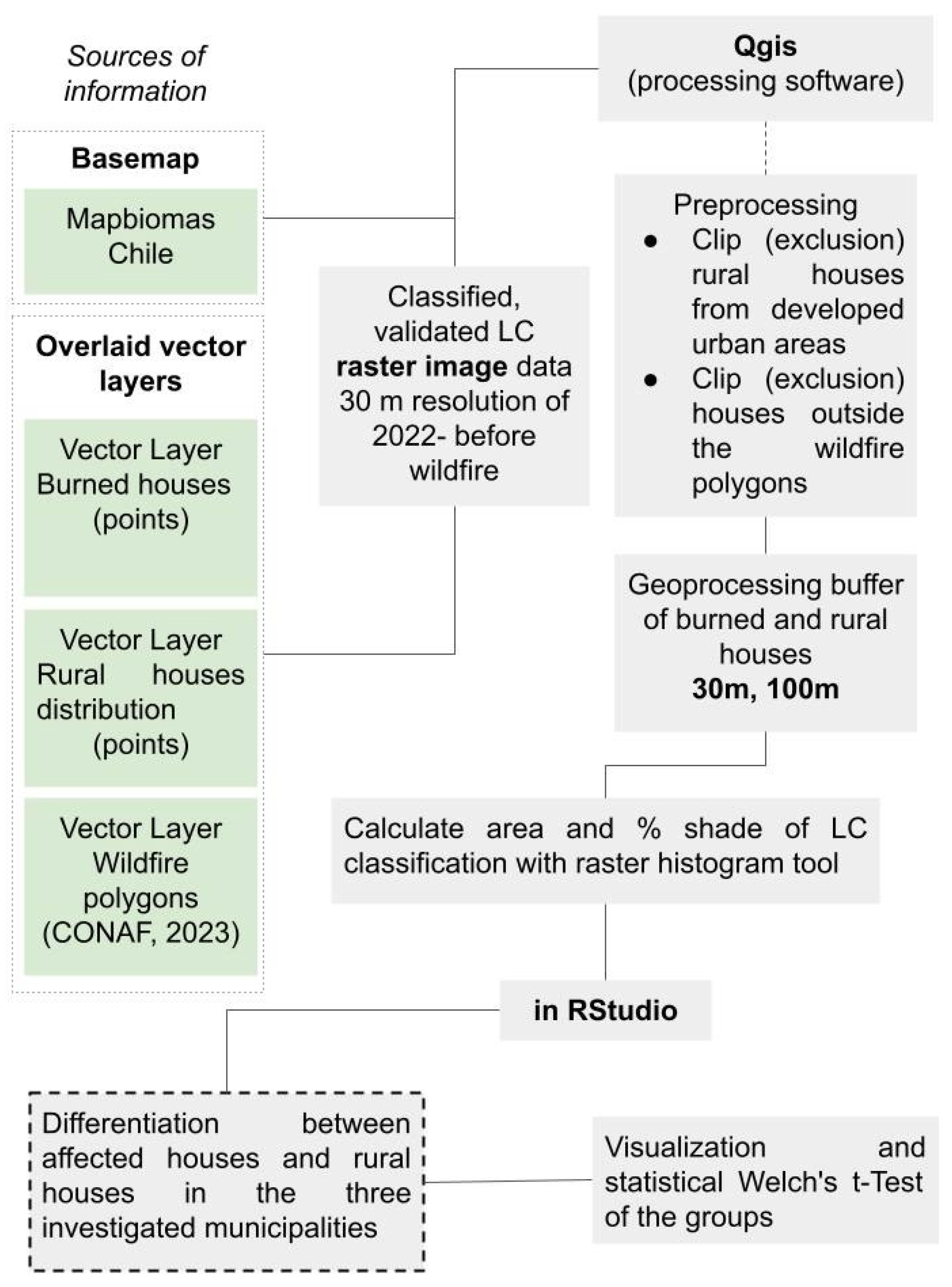
2. Materials and Methods

This section outlines the materials and methods used to analyze the impact of wildfires on land cover (LC) and housing in the Bío-Bío region, Chile. A proximity-based spatial analysis was conducted to assess the relationships between LC types, building distributions, and wildfire risk. The study combines high-resolution geospatial data, statistical techniques, and GIS tools to evaluate the patterns of fire damage and identify critical risk factors. By focusing on the most affected municipalities, the methodology ensures a robust and spatially valid analysis, providing insights into wildfire mitigation strategies.

2.1. Study Area

Three study areas (the municipal areas of Nacimiento, Santa Juana and Tomé) within the Bío-Bío region were selected. The Bío-Bío Region is situated between latitudes 36°26′ and 38°29′ south and between 71°30′ and 73°30′ west featuring a transitional climate that bridges warm Mediterranean conditions with humid or rainy climates. This climatic diversity supports a wide range of vegetation and underpins economic activities related to agriculture and forestry.
There are 33 municipalities within the region’s boundaries, and our study focuses on the 3 municipalities that were most affected by the wildfires occurring in February 2023. These are Nacimiento, Tomé and Santa Juana, all of which are located west of this region. Figure 1 provides an overview of the study area, illustrating the geographic location of these municipalities within the Bío-Bío region, as well as the spatial distribution of wildfires.
The rationale for selecting these three municipalities relates to their predominant LC and that they were the most affected by the 2022–2023 wildfires, with a greater number of houses destroyed. Before the 2023 wildfires, the dominant land cover (LC) categories in the study areas were forest plantations, mosaics of agriculture and pasture, and native forests. These categories remained predominant after the fire, highlighting the widespread presence of fire-prone land use types. All of which are distributed uniformly and with similar percentage ratios across the valleys and highlands of the three municipalities. Other categories include infrastructure, wetlands and rivers, and other non-vegetated areas. Figure 2 presents a zoomed-in view of each municipality, displaying the pre-fire land cover (LC) conditions as recorded in 2022.
Furthermore, an aftermath study (Reporte F2 Incendios Biobío) carried out by the Ministerio de Vivienda y Urbanismo (MINVU) Biobío has mapped all the damaged or destroyed properties that were affected by the event that qualified to obtain a subsidy for the reconstruction of the dwelling [35]. A total of 879 affected properties were surveyed in the dataset. To limit our case studies, we focused on the municipalities of Nacimiento (135 affected houses), Santa Juana (377 affected houses) and Tomé (352 affected houses). They represent the three most affected regions by the wildfire events of 2023. The destruction occurred primarily in rural areas according to Chilean planning delimitations. One exception was the destruction of around 50 urban houses on the outskirts of the commune of Tomé, which were not included in the analysis because they are located in urban areas. In the commune of Santa Juana, an area of 61.35% of the municipal area, was affected by the wildfires. In Tomé and Nacimiento, around 42% of the municipal area was affected. This high percentage makes it clear that not only the damage to buildings is enormous but also that undeveloped LCs like forests, agricultural lands, and other natural areas were severely affected by the wildfires. Table 1 summarizes the rural housing situation in each municipality, detailing the number of affected properties, the proportion of burned rural houses relative to total housing stock, and the extent of the burned area within each municipality.

Dominance of Forest Plantation in All Affected Municipalities

The general (LC) analysis highlights that all three municipalities are heavily dominated by forest plantation LC, and that beyond natural forest formations, other LC types play a minimal role in the overall composition. Forest plantations dominate the land cover across all municipalities, with relative shares of 67.6% in Nacimiento, 74.7% in Santa Juana, and 82.4% in Tomé. Chilean forest plantations are dominated by densely planted, fire-prone species, primarily Pinus radiata (Monterey pine) and Eucalyptus species, notably Eucalyptus globulus and Eucalyptus nitens [37,38]. The second most significant LC class is natural forest, accounting for 18.7% in Nacimiento, 12.8% in Santa Juana, and 8.1% in Tomé. Agriculture and pasture mosaics (MAP) are more prominent in Nacimiento (7.4%) and Santa Juana (5.6%) but have a lesser presence in Tomé (3.1%). Other land cover types, such as shrubland, grassland, and miscellaneous classes, contribute minimally to the overall land cover composition. Figure 3 illustrates the relative shares of LC in each municipality, comparing total municipal area with the areas inside and outside the wildfire polygon.
A comparison of land cover (LC) inside and outside the fire spread polygon reveals notable differences; within the forest fire polygon, a positive correlation emerges between the affected areas and a higher proportion of plantation forests, particularly in Nacimiento and Santa Juana (see Figure 3). In Nacimiento, the proportion of forest plantations increases significantly to 82.1%, and in Santa Juana, it rises to 78.9%. In Tomé, where the overall share of forest plantations is already very high (82.4%), the increase within the fire spread polygon is more modest, reaching 83.7%.

2.2. Data Collection and Sources

The study adopts a quantitative and spatial approach using four data sources to analyze land-use coverage (LC) in a specific sample of houses damaged or destroyed during the 2023 wildfires in the Bío-Bío region, Chile. First, the sample (see Table 1) was selected from a specific sample of the Emergency Basic Form (FIBE) registry developed by MINVU (2023) [35], which identifies houses eligible for reconstruction subsidies. This subset is a critical representation of the total affected houses, focusing on the most severely impacted municipalities: Santa Juana, Tomé, and Nacimiento. The second source of information includes wildfire boundaries, obtained from the Infraestructura de Datos Espaciales of the Ministerio de Agricultura (Agriculture Ministry) [9]. These boundaries consist of shapefile-format vector polygons depicting the spatial extent of the 2023 wildfires. The third source is the land-use distribution from MapBiomas Chile for 2022 [34], Collection 1.0. This dataset consists of a raster map with a resolution of 30 m/pixel, derived from the classification of multiple spectral indices, which reflects pre-wildfire conditions of the case study. Lastly, to compare the number of burned houses with the FIBE registry sample (MINVU), the 2016 rural housing survey from the Instituto Nacional de Estadísticas (National Institute of Statistics) was used. This dataset maps all rural houses in the study area as a point shapefile and is updated every 10 years in conjunction with the national census.

2.3. Sample Design and Validation

2.3.1. Sample Size Calculation

To ensure a statistically robust representation, sample sizes were calculated using the finite population correction formula (Equation (1), [39]) with a 95% confidence level and a 5% margin of error. This resulted in 377 samples for Santa Juana and 367 for Tomé, exceeding the required minimums of 315 and 275, respectively, ensuring the accurate representation of population characteristics in these municipalities. However, in Nacimiento, the available sample size was only 135, significantly below the required 237 due to limited data availability, as it included only officially registered cases of fire-damaged homes. This limitation reduced the confidence level for this municipality, requiring cautious interpretation of findings from this area.
Equation (1): Finite Population Correction Formula
n = N Z 2 p 1 p e 2 N 1 + Z 2 p 1 p
where:
  • n: Required sample size;
  • N: Population size;
  • Z: Z-score for confidence level (1.96 for 95%);
  • p: Estimated proportion of the population (default 0.5 for maximum variability);
  • e: Margin of error.
Although the sample size for Nacimiento (n = 135) falls below the required minimum of 237, it is included in the analysis for several reasons. First, Nacimiento experienced significant wildfire damage, with 41.98% of its municipal area burned, highlighting its importance as a highly affected rural municipality. Second, the wildfire in Nacimiento is spatially continuous with the fire in Santa Juana, enabling the analysis of interconnected fire dynamics and land cover patterns across neighboring municipalities. Third, Nacimiento provides a valuable case for understanding wildfire impacts in sparsely populated rural settings, complementing the more urbanized context of Tomé. Finally, its inclusion facilitates a comparative analysis that informs public policy and planning strategies for municipalities facing similar challenges. Despite the reduced sample size in Nacimiento, its inclusion in the analysis is essential due to its significant wildfire impact (41.98% of the municipal area burned) and its spatial continuity with Santa Juana, allowing for a comparative assessment of fire dynamics across municipalities.

2.3.2. Spatial Validation

Spatial validation of the sample was conducted using multiple statistical tools in ArcMap 10.8 (ESRI) to ensure the spatial representativeness of the data within the fire polygons (burned areas) for each municipality. This approach focused on validating the clustering and dispersion patterns of fire-damaged houses while distinguishing these patterns from the broader municipal boundaries.
First, nearest neighbor analysis was employed to evaluate the clustering of fire-damaged houses by comparing the observed average distance between points to the expected distance in a random distribution. The results revealed significant clustering in all municipalities. For instance, in Santa Juana, the observed mean distance was 112.13 m, compared to an expected mean distance of 318.94 m, yielding a nearest neighbor ratio (NNR) of 0.351 and a Z-score of −52.04 (p-Value = 0.000). These results indicate a high degree of clustering, consistent with the proximity of rural residences to roads, water sources, and agricultural activity areas.
To complement this, the standard distance tool quantified the dispersion of fire-damaged houses within the fire polygons. In Santa Juana, 219 out of 381 points fell within one standard deviation of the center, indicating moderate dispersion. Tomé had 243 out of 345 points in the central area, while Nacimiento, despite its smaller sample, showed dense clustering with 79 of 118 points near the center.
Moran’s I Spatial Autocorrelation further confirmed the clustering patterns, with statistically significant positive spatial autocorrelation observed in all municipalities. In Santa Juana, the Moran’s I index was 0.263, with a Z-score of 2.93 (p-Value = 0.003), indicating that fire-damaged houses were not randomly distributed but exhibited spatial dependence. Similar results were observed in Tomé (Index = 0.271, Z-Score = 2.92, p-Value = 0.003) and Nacimiento (Index = 0.185, Z-Score = 8.51, p-Value = 0.000), underscoring the consistent spatial clustering of fire-damaged houses across the study area.
Additionally, High/Low Clustering (Getis-Ord General G) was performed to evaluate the clustering intensity of fire-damaged houses. Across all municipalities, the General G value was 0.00009, with a Z-Score of 6.91 (p-Value = 0.000), confirming significant clustering of fire-damaged houses within the fire polygons. These combined spatial analyses validate the robustness of the sample design and highlight significant clustering patterns within the fire polygons, providing critical insights for assessing wildfire impacts and informing mitigation strategies.

2.4. Spatial Analysis

2.4.1. Buffer Analysis—30 m and 100 m Buffer

The close-range buffer size (30 m) was chosen primarily to align with the 30 m resolution of the land cover (LC) data, ensuring that the analysis remained reliable and avoided inaccuracies from smaller buffers (e.g., 15 m), which could misrepresent land cover due to data granularity and minor positional errors in house locations. The maximum buffer size (100 m) was selected to provide a meaningful landscape-scale perspective without overextending into areas irrelevant to direct wildfire impacts, as larger buffers (e.g., 200 m) would dilute results by incorporating excessive, disconnected land cover patterns that do not reflect the study area’s small-scale, fragmented property boundaries and localized fire dynamics. These thresholds balance data accuracy, spatial relevance, and research objectives.
A larger buffer, such as 200 m (cf. Mancini et al., [40])—commonly applied as a threshold to delineate the Wildland–Urban Interface (WUI)—would significantly dilute the results. Such extensive buffers do not adequately represent the predominantly small-scale, fragmented LC patterns and complex property boundaries typical of the study area. Consequently, buffers exceeding 100 m were not considered appropriate for the research objectives of this study.
The raster dataset containing LC categories the year before the wildfire event in 2022 (MapBiomas, 2022) [34] was clipped using vector polygons of each buffer distance and analyzed with the raster layer histogram tool in QGIS. This tool calculates the pixel count for each LC class within the specified buffer distances. Thus, the number of pixels per LC category and buffer distances for each point in the data sample were established. To facilitate statistical evaluation and enhance comparability, the data were normalized and expressed as percentages.

2.4.2. Statistical Validation

The universe for this analysis was determined using pre-census cartography from the 2017 Census, updated by the National Institute of Statistics (INE) [36] in 2016 (Table 1). This base was overlaid with the burned area delineated by the 2023 fire polygon from CONAF & IDE MINAGRI (2023) [9], allowing for a detailed comparison with other rural houses within the study area. The georeferenced data points were categorized into two groups: the sample of burned rural houses from the FIBE registry and rural houses inside the wildfire propagation area, as defined by the 2023 wildfire contours established by CONAF and the Ministry of Agriculture (Figure 1). This facilitates addressing the third objective of the LC buffer analysis, as variations in the actual LC across the different buffer zones of the two groups are quantified, and their statistical significance is evaluated using Welch’s t-Test. Risk patterns, such as protective fringe LCs and danger fringe LCs, can be effectively identified from these results.
Welch’s t-test was used to compare two types of houses—affected houses and rural houses—within 30 m and 100 m buffer zones. This method is specifically designed to evaluate significant differences between two groups, even when variances and sample sizes are unequal, making it ideal for real-world datasets with variability. Compared to the Student’s t-test, Welch’s test is more robust under heteroscedasticity and effective for larger sample sizes. By generating both a t-value and a p-value, it facilitates the assessment of group differences.
The p-value quantifies the probability of observing a difference in means as extreme as the one found, assuming the null hypothesis (μ1 = μ1) is true. A small p-value (e.g., p < 0.05) indicates strong evidence against the null hypothesis, suggesting a significant difference, while a larger p-value suggests the difference may be due to chance. Welch’s t-test adjusts for unequal variances and sample sizes, ensuring accurate estimation. The t-value represents the difference between group means relative to variability and sample sizes, calculated as the ratio of the mean difference to the standard error. Larger absolute t-values indicate more pronounced differences, with smaller values reflecting less divergence. The t-value serves as the basis for computing the p-value. Welch’s t-test formula is described as follows, where:
t = X 1 ¯ X 2 ¯ s 1 2 n 1 + s 2 2 n 2
where:
  • X 1 ¯ and X 2 ¯ → mean (average) of sample 1 and sample 2, respectively.
  • s 1 2 and s 2 2 → variance of sample 1 and sample 2, respectively
  • n 1 and n 2 → sample size (number of observations) in sample 1 and sample 2.
The use of Welch’s t-test aligns with best practices in statistical analysis. Ruxton [41] emphasized its advantages over methods such as Student’s t-test and the Mann–Whitney U test, particularly for data with unequal variances. Derrick et al. [42] further supported its utility, demonstrating that Welch’s test maintains Type I error rates close to nominal levels under unequal variances and sample sizes, reinforcing its robustness and applicability in diverse contexts.
The overall statistical workflow and integration of GIS-based LC buffer analyses are summarized in Figure 4, which outlines the methodological process employed to determine the land cover distribution within each buffer distance and the application of statistical tests.

2.5. Scaling Land Cover Analysis

The LC dataset was analyzed on three different scales. Percentages of LC were calculated for the entirety of the surface areas considered, which include: (1) affected houses inside the wildfire polygon, (2) rural houses outside the wildfire polygon, and (3) total area of the municipality. A detailed assessment was conducted in buffer areas (30 m and 100 m) according to the distribution of rural houses within the municipalities of Nacimiento, Santa Juana, and Tomé.

3. Results

3.1. Proximity Breeds Peril: Nearness of Forests Plantations in Amplifying Housing Damage or Loss Risk

The proximity of plantation forests, predominantly consisting of highly flammable eucalyptus and pine trees, was a significant factor in the extent of damage to homes during the 2023 wildfires in the Bío-Bío region. Within a 30 m buffer around affected houses, the average proportion of plantation forests was 51% in Nacimiento, 53% in Santa Juana, and a very high 73% in Tomé. In contrast, rural houses in the area of interest exhibited considerably lower averages of 32%, 35%, and 50%, respectively. Statistical analysis using Welch T-tests confirmed these differences as highly significant, with large positive T-values (Nacimiento: 4.58, Santa Juana: 7.61, Tomé: 9.52) and p-values near zero.
Among all land cover classes analyzed, plantation forests demonstrated the largest disparities in mean values and the highest T-values, clearly identifying them as the leading contributor to the increased risk of housing damage or total loss. This pattern remained consistent throughout all municipalities, with slightly higher averages observed when the buffer was expanded to 100 m. Figure 5 and Figure 6 and Table 2 summarize these patterns, illustrating the stark contrast in forest plantation proximity between affected and non-affected rural houses.

3.2. Neither Protective nor Risky: Minimal Measurable Differences in Forest Land Cover

The results of the analysis of the forest land cover (LC) class reveal minimal differences between affected houses and rural houses in the buffer analysis. Notably, the proportion of this LC class within the buffers is consistently low across all municipalities, with average values ranging from a minimum of 4.5% for affected houses in Santa Juana to a maximum of 7.7% for rural houses in Nacimiento.
Statistical analysis indicates that, apart from a small but significant difference in Santa Juana, the forest class does not show significant variation between affected houses and rural houses within the 30 m buffer. This pattern remains consistent in the 100 m buffer analysis, where the average values are slightly higher but still exhibit no significant differences between the groups. These findings suggest that the forest LC class plays a limited role in determining the risk or extent of housing damage during the wildfires in these areas. Table 2 presents Welch’s t-test results, confirming these observations. In the table, significance levels are categorized into four distinct groups for clarity: results with a p-value < 0.01 are marked with *** and considered very significant; those with a p-value < 0.05 are labeled ** and deemed significant; findings with a p-value < 0.1 are indicated with * and classified as weakly significant; and results with a p-value ≥ 0.1 are marked as “ns” and considered not significant. This classification helps to easily interpret the strength of statistical evidence.

3.3. Protective Role of Mosaic Agricultural and Pasture LC During Wildfire Events

The LC Mosaic of Agriculture and Pasture (MAP) reveals notable differences among the groups analyzed. Within the 30 m buffer zone around rural houses, the average values are relatively high, with 28.8% in Nacimiento and 29% in Santa Juana. However, the proportion around affected houses is significantly lower with 17.7% in Nacimiento and 20.1% in Santa Juana. In Tomé, the proportion around rural houses is also low at 11.2%, and the proportion around affected houses decreases by nearly half, dropping to 6.2%.
A similar trend is observed within the 100 m buffer zone across all three municipalities. These findings are statistically supported by significant negative t-values from Welch’s t-test, ranging from −3.51 in Nacimiento to −4.37 in Santa Juana. This indicates significant differences in land cover characteristics that correlate with enhanced protective functions during large-scale forest fires, such as the 2023 event. Figure 5 and Table 2 illustrate these protective effects in detail.

3.4. Protective Function with a Certain Degree of Uncertainty of the Shrubland LC

In the Shrubland LC, the average percentage values for the 30 m buffer are lower around affected houses compared to rural houses, but the differences are less pronounced. In Nacimiento, rural houses account for 21%, while affected houses account for 18%. Similarly, in Santa Juana, rural houses account for 17.9% and affected houses 14%. However, in Tomé, the differences are more marked, with 18.6% for rural houses and 9.4% for affected houses. Statistical analysis supports these findings only partially. In Nacimiento, the high p-value of 0.12 indicates that a statistically significant difference cannot be confirmed for the 30 m buffer. In contrast, the differences in Santa Juana and Tomé are statistically significant, with p-values close to 0. Shrublands also demonstrated a moderate protective effect, although the statistical significance remains uncertain.

4. Discussion

Our study advances wildfire impact assessment through an integrated analysis of land cover patterns and structural vulnerability in Chile’s Bío-Bío region. By combining high-resolution geospatial data with robust statistical methods, we have developed a replicable framework that reveals critical relationships between landscape characteristics and wildfire damage while providing actionable policy insights.
The methodological approach represents a significant step forward in wildfire research. The innovative use of multi-scale buffer analysis (30 m and 100 m) allows for simultaneous examination of both immediate and landscape-level land cover influences, while spatial validation techniques and Welch’s t-test effectively address the sampling challenges inherent to wildfire studies. Focusing on the most severely affected municipalities—Nacimiento, Santa Juana, and Tomé—ensured our analysis captured genuine patterns of fire impact while maintaining spatial relevance. This comprehensive approach provides a model for future studies in other fire-prone regions.
The 30 m buffer analysis reveals clear differences in fire impact across land cover types. Forest plantations show the highest levels of asset loss (AH_mean), with statistically significant differences in all communes, particularly in Tomé, where the average asset loss reaches 73.28 compared to 50.04 in reference rural households. In contrast, natural forests exhibit no significant differences in most areas, suggesting a neutral effect on fire-related damage. Mixed Agricultural Patches (MAPs) consistently function as protective landscapes, with significantly lower asset loss across all sites, confirming their buffering role. Similarly, shrublands demonstrate a lower fire impact than plantation forests, especially in Tomé, where the difference is most pronounced. These findings underscore the importance of vegetation type in determining fire vulnerability and highlight the potential of MAPs and shrublands in fire-resilient land use planning that aligns with previous research [22,25].
Our buffer analysis reinforces the importance of proximity, revealing that vegetation within 30 m of structures is consistently associated with significant differences in fire-related asset loss. While both 30 m and 100 m buffers yield meaningful results, the immediate surroundings of structures—particularly in plantation and agricultural areas—emerge as critical zones of influence. This observation aligns with and adds spatial precision to the proximity principle described by Aguirre et al. [26].
These findings carry important implications for wildfire policy and land management. The clear proximity effects we documented strongly support implementing defensible space standards like Australia’s successful models [43,44], particularly the establishment of 30 m low-fuel zones around vulnerable structures. It is essential for the implementation of these buffers that they are enforceable—for instance through development standards required in permit applications—rather than simply as recommendations or guidelines as they are now recommended in Chile by Conaf [45] with limited real implementation, as shown by the results of this research. In the Chilean context, such regulations could be integrated into the Ordenanza General de Urbanismo y Construcciones (OGUC) or municipal Planes Reguladores, extending risk management criteria to rural territories. More broadly, our results suggest the need for revised land use zoning that restricts high-risk vegetation types near settlements, complemented by incentive programs to encourage fire-resilient land uses like mosaic agriculture. These incentives could take the form of conditional subsidies for rural landowners or targeted training for vegetation management. To implement these measures, a territorial approach to land use planning that considers all land—rather than a system that makes governance and regulatory differences between urban and rural land, such as the Chilean planning system, that strongly focuses on urban areas with limited direction for rural areas—is essential [46]. This also implies the strengthening of intersectoral coordination, for example between MINVU, CONAF, and local governments, to ensure multi-scalar and effective governance of wildfire risk. Furthermore, such measures would need to be implemented sensitively, considering the economic importance of forestry in the region while progressively moving toward more fire-adapted landscapes.

5. Conclusions

This study presents a spatially detailed assessment of wildfire impacts on land cover (LC) and housing in the Bío-Bío region, Chile, using high-resolution geospatial data and statistical techniques. By integrating GIS tools with spatial analysis methods such as nearest neighbor analysis, standard distance tool, zonal histogram and Moran’s I Spatial Autocorrelation, the study provides a clear characterization of fire damage patterns. A key methodological strength of the study lies in the use of proximity-based spatial analysis and multi-scale buffer analyses (30 m and 100 m), which allow for a fine-grained assessment of LC variations around fire-damaged houses. The selection of the most affected municipalities—Nacimiento, Santa Juana, and Tomé—based on empirical damage data enhances the relevance and applicability of the findings.
The results highlight strong spatial correlations between fire damage and specific LC types, with plantation forestry and shrublands emerging as high-risk categories, while certain LC types, such as agricultural and pasture LC, appear to offer greater resilience to wildfire spread. Notably, the LC within a 30 m buffer has a greater influence on the loss or survival of structures in a wildfire, emphasizing the importance of vegetation management in the immediate surroundings of housing for wildfire mitigation. Additionally, Welch’s t-test confirms statistically significant differences in LC composition between affected and unaffected areas, supporting the consistency of spatial findings with statistical evidence.
This study also advances both theoretical and practical understanding of the relation between LC and housing destruction, particularly in the context of the 2023 Wildland–Urban Interface (WUI) fires in Chile. It addresses a critical knowledge gap in wildfire research: the limited understanding of LC dynamics and fire behavior patterns in Chilean WUI areas. By focusing on this underexplored context, the study contributes to a more nuanced assessment of wildfire vulnerability and reinforces the value of integrating spatial and statistical analyses to identify risk factors across multiple scales. Practically, the study offers a replicable methodology that can be applied to other wildfire-prone regions worldwide, helping decision-makers refine risk assessment models and mitigation strategies. By identifying LC types associated with higher wildfire risk, this study informs land use planning and supports the implementation of targeted, evidence-based fire management policies. In particular, our results can inform zoning revisions, legally enforceable defensible space regulations, and the design of economic instruments that promote fire-resilient land uses. The broader implications of this research extend to multiple audiences, including policymakers, land managers, urban planners, and local communities.
We must acknowledge several study limitations that point to valuable directions for future research. While Nacimiento’s inclusion was justified by its severe fire impact (41.98% burned total area) and consistent patterns with neighboring areas, its relatively small sample size (n = 135) requires cautious interpretation of municipality-specific results. The 30 m resolution of our land cover data, while sufficient for landscape-scale analysis, may not capture finer vegetation patterns immediately surrounding structures. Future studies could benefit from incorporating higher-resolution data sources like UAV or LiDAR for critical areas. Additionally, while our analysis focused on physical landscape factors, we recognize that social and economic dimensions—including community adaptation strategies and land management practices play crucial roles in wildfire risk that warrant dedicated investigation.
Looking forward, this study highlights several promising research directions. The clear importance of proximate land cover suggests value in higher-resolution analysis of structure-adjacent vegetation characteristics. Longitudinal studies tracking land cover changes before and after fires could further clarify causal relationships while incorporating climate projections would help assess how changing conditions might modify the risk patterns we have identified. Perhaps most importantly, integrating these physical findings with social vulnerability assessments could yield more comprehensive strategies for building fire-resilient communities. In addition, incorporating recent advances in machine learning—such as adversarial temporal convolutional networks used to correct forecasted dynamic fields [47]—could improve the spatial precision of wildfire prediction models and support more proactive planning.

Author Contributions

Conceptualization, B.H. and C.G.-M.; methodology, B.H., C.G.-M., N.A.-S. and T.T.; validation, B.H. and N.A.-S.; investigation, B.H., C.G.-M., N.A.-S. and T.T.; resources, B.H.; data curation, B.H. and N.A.-S.; writing—original draft preparation, B.H., C.G.-M., N.A.-S. and T.T.; writing—review and editing, B.H., C.G.-M., N.A.-S. and T.T.; visualization, T.T; supervision, B.H.; project administration, B.H.; funding acquisition, B.H. All authors have read and agreed to the published version of the manuscript.

Funding

This research was funded by CIGIDEN, Centro de Investigación para la Gestión Integrada del Riesgo de Desastres—Postdoc FONDAP 2022: Análisis del impacto de incendios forestales 2023 en la zona sur de Chile, PROYECTO 1522A0005 FONDAP 2022; and the Dirreción de Investigacíon y Creación Artística (DICA) of the Universidad Mayor.

Institutional Review Board Statement

Not applicable.

Informed Consent Statement

Not applicable.

Data Availability Statement

The raw data supporting the conclusions of this article will be made available by the authors on request.

Acknowledgments

We sincerely appreciate the community workers of Santa Juana and Tomé for their invaluable insights, which greatly contributed to our research. Furthermore, we extend our gratitude to the affected residents of Santa Juana and Tomé, whose willingness to share their experiences and perspectives significantly enriched our analysis.

Conflicts of Interest

The authors declare no conflicts of interest. The funders had no role in the design of the study; in the collection, analyses, or interpretation of data; in the writing of the manuscript; or in the decision to publish the results.

References

  1. Suazo Caamaño, N.; Torres Salinas, R. Fracturas Metabólicas Del Extractivismo Forestal En Comunidades Campesinas: Caso Tomé, Chile. Campos Cienc. Soc. 2023, 11. [Google Scholar] [CrossRef]
  2. Baker, B.; Dinh, Y.; Foxfoot, I.R.; Ortiz, E.; Sells, A.; Anderson, S.E. Social Inequity and Wildfire Response: Identifying Gaps and Interventions in Ventura County, California. Fire 2024, 7, 41. [Google Scholar] [CrossRef]
  3. Duarte, E.; Rubilar, R.; Matus, F.; Garrido-Ruiz, C.; Merino, C.; Smith-Ramirez, C.; Aburto, F.; Rojas, C.; Stehr, A.; Dörner, J.; et al. Drought and Wildfire Trends in Native Forests of South-Central Chile in the 21st Century. Fire 2024, 7, 230. [Google Scholar] [CrossRef]
  4. Villagra, P.; Paula, S. Wildfire Management in Chile: Increasing Risks Call for More Resilient Communities. Environ. Sci. Policy Sustain. Dev. 2021, 63, 4–14. [Google Scholar] [CrossRef]
  5. Hora, B.; Almonacid, F.; González-Reyes, A. Unraveling the Differences in Landcover Patterns in High Mountains and Low Mountain Environments within the Valdivian Temperate Rainforest Biome in Chile. Land 2022, 11, 2264. [Google Scholar] [CrossRef]
  6. Gonzalez-Reyes, A.; Jacques-Coper, M.; Bravo-Lechuga, C.; Garreaud, R.; Rojas, M. Evolution of Heatwaves in Chile Since 1980. Weather. Clim. Extrem. 2023, 41, 100588. [Google Scholar] [CrossRef]
  7. Williams, C.J. Climate Change in Chile: An Analysis of State-of-the-Art Observations, Satellite-Derived Estimates and Climate Model Simulations. J. Earth Sci. Clim. Change 2017, 8, 400. [Google Scholar] [CrossRef]
  8. Carrasco-Escaff, T.; Garreaud, R.; Bozkurt, D.; Jacques-Coper, M.; Pauchard, A. The Key Role of Extreme Weather and Climate Change in the Occurrence of Exceptional Fire Seasons in South-Central Chile. Weather Clim. Extrem. 2024, 45, 100716. [Google Scholar] [CrossRef]
  9. CONAF & IDE MINAGRI Incendios Forestales. Localización de Incendios Forestales a Nivel de Puntos (CONAF). Available online: https://ide.minagri.gob.cl/geoweb/2019/11/21/desastres/ (accessed on 12 November 2024).
  10. Wildfire Exchange The 2022–2023 Fire Season Has Been One of the Most Devastating in Chilean History, Affecting More than 458.000 Hectares. Available online: https://wildfirex.com.au/chile-wildfire-season-2023/ (accessed on 12 November 2024).
  11. Coper, M.J. Análisis (CR)2|Meteorología Extrema: Uno de los Factores tras los Incendios de Febrero 2023 en el Centro-sur de Chile; Centro de Ciencia del Clima y la Resiliencia-CR2: Santiago, Chile, 2023. [Google Scholar]
  12. Modugno, S.; Balzter, H.; Cole, B.; Borrelli, P. Mapping Regional Patterns of Large Forest Fires in Wildland–Urban Interface Areas in Europe. J. Environ. Manag. 2016, 172, 112–126. [Google Scholar] [CrossRef]
  13. Sarricolea Espinoza, P.; Serrano Notivoli, R.; Fuentealba, M.; Hernández Mora, M.; de la Barrera, F.; Smith Guerra, P.; Meseguer Ruiz, Ó. Recent Wildfires in Central Chile: Detecting Links between Burned Areas and Population Exposure in the Wildland Urban Interface. Sci. Total Environ. 2020, 706, 135894. [Google Scholar] [CrossRef]
  14. Marchant, C.; Riesco, M.; Monje-Hernández, Y. Crecimiento y fragmentación del periurbano valdiviano. Efectos del urbanismo neoliberal en una ciudad intermedia del sur de Chile. Rev. EURE-Rev. Estud. Urbano Reg. 2023, 49, 1–25. [Google Scholar] [CrossRef]
  15. Calviño-Cancela, M.; Chas-Amil, M.L.; García-Martínez, E.D.; Touza, J. Wildfire Risk Associated with Different Vegetation Types within and Outside Wildland-Urban Interfaces. For. Ecol. Manag. 2016, 372, 1–9. [Google Scholar] [CrossRef]
  16. Wulder, M.A.; Loveland, T.R.; Roy, D.P.; Crawford, C.J.; Masek, J.G.; Woodcock, C.E.; Allen, R.G.; Anderson, M.C.; Belward, A.S.; Cohen, W.B.; et al. Current Status of Landsat Program, Science, and Applications. Remote Sens. Environ. 2019, 225, 127–147. [Google Scholar] [CrossRef]
  17. Zhao, Q.; Yu, L.; Li, X.; Peng, D.; Zhang, Y.; Gong, P. Progress and Trends in the Application of Google Earth and Google Earth Engine. Remote Sens. 2021, 13, 3778. [Google Scholar] [CrossRef]
  18. Brown, C.F.; Brumby, S.P.; Guzder-Williams, B.; Birch, T.; Hyde, S.B.; Mazzariello, J.; Czerwinski, W.; Pasquarella, V.J.; Haertel, R.; Ilyushchenko, S.; et al. Dynamic World, Near Real-Time Global 10 m Land Use Land Cover Mapping. Sci. Data 2022, 9, 251. [Google Scholar] [CrossRef]
  19. Price, O.F.; Bradstock, R.A. The Spatial Domain of Wildfire Risk and Response in the Wildland Urban Interface in Sydney, Australia. Nat. Hazards Earth Syst. Sci. 2013, 13, 3385–3393. [Google Scholar] [CrossRef]
  20. Oliveira, S.; Gonçalves, A.; Benali, A.; Sá, A.; Zêzere, J.L.; Pereira, J.M. Assessing Risk and Prioritizing Safety Interventions in Human Settlements Affected by Large Wildfires. Forests 2020, 11, 859. [Google Scholar] [CrossRef]
  21. Gonzalez-Mathiesen, C. Resilience to Wildfires: Comparative Insights of Barriers and Facilitators for Spatial Planning in Victoria and Chile. Cities 2024, 154, 105389. [Google Scholar] [CrossRef]
  22. Gonzalez-Mathiesen, C.; Ruane, S.; March, A. Integrating Wildfire Risk Management and Spatial Planning–A Historical Review of Two Australian Planning Systems. Int. J. Disaster Risk Reduct. 2021, 53, 101984. [Google Scholar] [CrossRef]
  23. Moritz, M.A.; Hazard, R.; Johnston, K.; Mayes, M.; Mowery, M.; Oran, K.; Parkinson, A.-M.; Schmidt, D.A.; Wesolowski, G. Beyond a Focus on Fuel Reduction in the WUI: The Need for Regional Wildfire Mitigation to Address Multiple Risks. Front. For. Glob. Change 2022, 5, 848254. [Google Scholar] [CrossRef]
  24. Ortiz, A.M.D.; Gayó, E.M.; Henríquez, N.C.; Henríquez, B.J.; Pauchard, A. Exploring the Multifunctional Landscapes Model in Areas Dominated by Non-Native Tree Plantations. Trees For. People 2024, 17, 100617. [Google Scholar] [CrossRef]
  25. Syphard, A.D.; Keeley, J.E.; Massada, A.B.; Brennan, T.J.; Radeloff, V.C. Housing Arrangement and Location Determine the Likelihood of Housing Loss Due to Wildfire. PLoS ONE 2012, 7, e33954. [Google Scholar] [CrossRef] [PubMed]
  26. Aguirre, P.; León, J.; González-Mathiesen, C.; Román, R.; Penas, M.; Ogueda, A. Modelling the Vulnerability of Urban Settings to Wildland–Urban Interface Fires in Chile. Nat. Hazards Earth Syst. Sci. 2024, 24, 1521–1537. [Google Scholar] [CrossRef]
  27. Mancilla-Ruiz, D.; de la Barrera, F.; González, S.; Huaico, A. The Effects of a Megafire on Ecosystem Services and the Pace of Landscape Recovery. Land 2021, 10, 1388. [Google Scholar] [CrossRef]
  28. Pozo, R.A.; Galleguillos, M.; González, M.E.; Vásquez, F.; Arriagada, R. Assessing the Socio-Economic and Land-Cover Drivers of Wildfire Activity and Its Spatiotemporal Distribution in South-Central Chile. Sci. Total Environ. 2022, 810, 152002. [Google Scholar] [CrossRef]
  29. Bajocco, S.; Ferrara, C.; Guglietta, D.; Ricotta, C. Fifteen Years of Changes in Fire Ignition Frequency in Sardinia (Italy): A Rich-Get-Richer Process. Ecol. Indic. 2019, 104, 543–548. [Google Scholar] [CrossRef]
  30. Castro-Díez, P.; Alonso, Á.; Saldaña-López, A.; Granda, E. Effects of Widespread Non-Native Trees on Regulating Ecosystem Services. Sci. Total Environ. 2021, 778, 146141. [Google Scholar] [CrossRef]
  31. Armenteras, D.; De La Barrera, F. Landscape Management Is Urgently Needed to Address the Rise of Megafires in South America. Commun. Earth Environ. 2023, 4, 305. [Google Scholar] [CrossRef]
  32. Paolucci, R.; Yilmaz, M.T. Simplified Theoretical Approaches to Earthquake Fault Rupture–Shallow Foundation Interaction. Bull. Earthq. Eng. 2008, 6, 629–644. [Google Scholar] [CrossRef]
  33. Park, K.; Won, J. Analysis on Distribution Characteristics of Building Use with Risk Zone Classification Based on Urban Flood Risk Assessment. Int. J. Disaster Risk Reduct. 2019, 38, 101192. [Google Scholar] [CrossRef]
  34. MapBiomas Chile Project-Collection 2022 of the Annual Series of Land Cover and Land Use Maps of Chile, Consulted on [08th of January 2025]. Available online: https://storage.googleapis.com/mapbiomas-public/initiatives/chile/coverage/chile_coverage_2022.tif (accessed on 12 November 2024).
  35. Reporte F2 Incendios Biobío 2023. Available online: https://minvu.maps.arcgis.com/apps/webappviewer/index.html?id=b39290102ab34e1e9fbb70b7ae7e5b40 (accessed on 12 November 2024).
  36. Geodatos Abiertos. Available online: https://www.ine.gob.cl/herramientas/portal-de-mapas/geodatos-abiertos (accessed on 12 November 2024).
  37. Guerrero, F.; Carmona, C.; Hernández, C.; Toledo, M.; Arriagada, A.; Espinoza, L.; Bergmann, J.; Taborga, L.; Yañez, K.; Carrasco, Y.; et al. Drivers of Flammability of Eucalyptus Globulus Labill Leaves: Terpenes, Essential Oils, and Moisture Content. Forests 2022, 13, 908. [Google Scholar] [CrossRef]
  38. Salas, C.; Donoso, P.J.; Vargas, R.; Arriagada, C.A.; Pedraza, R.; Soto, D.P. The Forest Sector in Chile: An Overview and Current Challenges. J. For. 2016, 114, 562–571. [Google Scholar] [CrossRef]
  39. Lohr, S.L. Sampling: Design and Analysis; Chapman and Hall/CRC: Boca Raton, FL, USA, 2021; ISBN 0-429-29889-7. [Google Scholar]
  40. Mancini, L.D.; Elia, M.; Barbati, A.; Salvati, L.; Corona, P.; Lafortezza, R.; Sanesi, G. Are Wildfires Knocking on the Built-Up Areas Door? Forests 2018, 9, 234. [Google Scholar] [CrossRef]
  41. Ruxton, G.D. The Unequal Variance T-Test Is an Underused Alternative to Student’s t-Test and the Mann–Whitney U Test. Behav. Ecol. 2006, 17, 688–690. [Google Scholar] [CrossRef]
  42. Derrick, B.; White, P. Why Welch’s Test Is Type I Error Robust. Quant. Methods Psychol. 2016, 12, 30–38. [Google Scholar] [CrossRef]
  43. Gonzalez-Mathiesen, C.; March, A. Establishing Design Principles for Wildfire Resilient Urban Planning. Plan. Pract. Res. 2018, 33, 97–119. [Google Scholar] [CrossRef]
  44. Gonzalez-Mathiesen, C.; March, A. Developing Guidelines for Increasing the Resilience of Informal Settlements Exposed to Wildfire Risk Using a Risk-Based Planning Approach. In Understanding Disaster Risk; Elsevier: Amsterdam, The Netherlands, 2021; pp. 159–178. ISBN 978-0-12-819047-0. [Google Scholar]
  45. Corporación Nacional Forestal (CONAF). Cómo Reducir el Riesgo de Afectación por Incendios Forestales en Viviendas Rurales; Corporación Nacional Forestal (CONAF): Santiago, Chile, 2023. [Google Scholar]
  46. Gonzalez-Mathiesen, C.; March, A. Long-Established Rules and Emergent Challenges: Spatial Planning and Wildfires in Chile. Int. Plan. Stud. 2023, 28, 37–53. [Google Scholar] [CrossRef]
  47. Ren, P.; Jia, Q.; Xu, Q.; Li, Y.; Bi, F.; Xu, J.; Gao, S. Oil Spill Drift Prediction Enhanced by Correcting Numerically Forecasted Sea Surface Dynamic Fields With Adversarial Temporal Convolutional Networks. IEEE Trans. Geosci. Remote Sens. 2025, 63, 4701018. [Google Scholar] [CrossRef]
Figure 1. Map of the study area. Sources of information: wildfire distribution from the CONAF & IDE MINAGRI (2023) [9].
Sustainability 17 04416 g001
Figure 2. Zoomed in maps of the investigated municipalities with pre- LC in 2022 (MapBiomas, 2022) [34].
Sustainability 17 04416 g002
Figure 3. Shares of LC in the investigated municipalities comparing the total area of the commune with the shares of the areas inside and outside of the wildfire proliferation polygon. FP = forest plantation, MAP = matice of agriculture and pastureland, OC = other classes.
Sustainability 17 04416 g003
Figure 4. Workflow of methodology incorporating the different sources of information and QGIS to determine the land use of each category within the buffer distances considered and statistical tests.
Sustainability 17 04416 g004
Figure 5. Shares of LCs within the analyzed 30 m buffer of affected houses and rural houses in the AOI ordered by relevance (forest plantations, forests, Mosaic of Agriculture and Pasture (MAP) and shrubland.
Sustainability 17 04416 g005
Figure 6. Shares of LCs within the analyzed 100 m buffer of affected houses and rural houses in the AOI ordered by relevance (forest plantations, forests, Mosaic of Agriculture and pasture (MAP) and shrubland.
Sustainability 17 04416 g006
Table 1. Rural housing situation by investigated municipalities (MINVU 2023 [35], INE 2017 [36]).
Affected MunicipalityAffected Rural Houses Qualified for Reconstruction Subsidy (MINVU, 2023)Number of Rural Houses Within the Wildfire PolygonRural Houses Outside the Wildfire PolygonTotal Rural Houses (INE, 2016)Share of Affected Rural Houses Qualified for Subsidy (%)Total Population of the MunicipalityTotal Area of the Municipality (km2)Total Burned Area Within the Municipality (km2)Burned Area of the Municipal Land (%)
Nacimiento135611139220036.728,39293539241.98
Santa Juana37717581002276013.713,74973144861.35
Tomé3529682624359210.254,97649420641.88
Table 2. Results of Welch’s t-test comparing land cover (LC) characteristics within 30 m and 100 m buffer zones around Affected Houses (AF) and Rural Houses (RH) in the municipalities of Nacimiento, Santa Juana, and Tomé. The analysis includes four LC classes: Forest Plantation, Forest, Mosaic of Agriculture and Pasture (MAP), and Shrubland. Reported values include group means (AH_mean and RH_mean), standard deviations (std), sample sizes (size), t-values, and p-values. The Significance column indicates the strength of statistical evidence: *** (p< 0.001, highly significant), ** (p < 0.01), * (p < 0.05), and ns (p ≥ 0.05, not significant).
BufferLand CoverCommunet-Valuep-ValueSignificanceAH_meanRH_meanAH_stdRH_stdAH_sizeRH_size
30 m bufferForest plantationNacimiento4.580.00***51.0032.1443.940.7135611
Santa Juana7.610.00***53.4135.0642.841.03771758
Tomé9.520.00***73.2850.0437.543.5352968
ForestNacimiento−0.510.61ns6.797.7519.521.4135611
Santa Juana−1.870.06*4.546.3416.120.53771758
Tomé0.480.63ns6.165.5919.518.1352968
MAPNacimiento−3.510.00***17.7428.8432.038.7135611
Santa Juana−4.370.00***20.1229.0435.239.33771758
Tomé−3.730.00***6.1811.2320.026.0352968
ShrublandNacimiento−1.570.12ns23.1028.9138.540.4135611
Santa Juana−3.850.00***17.7525.2133.337.73771758
Tomé−7.410.00***12.5827.4829.339.5352968
100 m bufferForest plantationNacimiento4.080.00***55.0142.8231.630.8135611
Santa Juana8.820.00***59.5444.1730.631.43771758
Tomé10.050.00***75.7858.5826.330.7352968
ForestNacimiento0.040.97ns8.688.6314.515.2135611
Santa Juana−1.990.05**5.977.3611.714.93771758
Tomé0.100.92ns8.318.2215.314.2352968
MAPNacimiento−3.780.00***16.7425.3422.928.1135611
Santa Juana−6.520.00***18.1927.1023.128.23771758
Tomé−5.770.00***5.0710.0412.417.2352968
ShrublandNacimiento−1.240.22ns17.9921.0225.725.3135611
Santa Juana−3.270.00***13.9617.8620.622.83771758
Tomé−7.270.00***9.4518.6118.424.6352968
Disclaimer/Publisher’s Note: The statements, opinions and data contained in all publications are solely those of the individual author(s) and contributor(s) and not of MDPI and/or the editor(s). MDPI and/or the editor(s) disclaim responsibility for any injury to people or property resulting from any ideas, methods, instructions or products referred to in the content.

