Article

Analysis of Water and Sediment Changes at Different Spatial Scales and Their Attribution in the Huangfuchuan River Basin

1
College of Desert Control Science and Engineering, Inner Mongolia Agricultural University, Hohhot 010018, China
2
Inner Mongolia Academy of Forestry Sciences, Hohhot 010010, China
3
Key Laboratory of Desert Ecosystem Conservation and Restoration, State Forestry and Grassland Administration of China, Hohhot 010018, China
*
Author to whom correspondence should be addressed.
Sustainability 2025, 17(10), 4389; https://doi.org/10.3390/su17104389
Submission received: 26 February 2025 / Revised: 24 April 2025 / Accepted: 9 May 2025 / Published: 12 May 2025

Abstract

:
Water–sediment evolution and attribution analysis in watersheds is one of the research focuses of hydrogeology. An in-depth investigation into the spatiotemporal variation of water and sediment at multiple spatial scales within the basin, along with a systematic assessment of the respective impacts of climate change and human activities, provides a scientific foundation for formulating effective soil and water conservation practices and integrated water resource management strategies. This research holds significant implications for the sustainable development and ecological management of the basin. In this study, the Mann–Kendall nonparametric test method, double cumulative curve method, cumulative anomaly method, and cumulative slope change rate analysis method were used to quantitatively study the effects of climate change and human activities on runoff and sediment load changes at different spatial scales in the Huangfuchuan River basin. The results show that (1) from 1966 to 2020, the annual runoff and annual sediment load discharge in the Huangfuchuan River basin showed a significant decreasing trend. Among them, the reduction in runoff and sediment in the control sub-basin of Shagedu Station in the upper reaches was more obvious than that in the whole basin. The mutation points of runoff and sediment load in the two basins were 1979 and 1998. The water–sediment relationship exhibits a power function pattern. (2) After the abrupt change, in the change period B (1980–1997), the contribution rates of climate change and human activities to runoff and sediment load reduction in the Huangfuchuan River basin were 24.12%, 75.88% and 20.05%, 79.95%, respectively. In the change period C (1998–2020), the contribution rates of the two factors to the runoff and sediment load reduction in the Huangfuchuan River basin were 18.91%, 81.09% and 15.61%, 84.39%, respectively. Among them, the influence of precipitation in the upper reaches of the Huangfuchuan River basin on the change in runoff and sediment load is higher than that of the whole basin, and the influence on the decrease of sediment load discharge is more significant before 1998. There are certain stage differences and spatial scale effects. (3) Human activities such as large-scale vegetation restoration and construction of silt dam engineering measures are the main reasons for the reduction in runoff and sediment load in the Huangfuchuan River basin and have played a greater role after 1998.

1. Introduction

As the most dynamic components of the watershed system, river runoff and sediment load are closely linked to hydrological conditions and exert significant influences on regional ecological security as well as socio-economic development. Due to the impacts of global and regional climate change, as well as human activities, river basin runoff and sediment load have gradually decreased, leading to alterations in the hydrological cycle to some extent. This phenomenon is particularly evident in arid and semi-arid regions [1]. In China, human activities—including water resource management, land use patterns, and changes to underlying surfaces—affect the mechanisms of runoff generation and confluence in river basins. These influences contribute to uneven distribution of water resources and conflicts related to ecological water use [2]. Therefore, it is essential to identify the changing characteristics and trends of runoff and sediment load in the river basins, as well as to analyze the underlying causes of these changes, to ensure sustainable strategic management of the region.
China’s Loess Plateau, situated in the middle reaches of the Yellow River, is one of the most severely affected areas in the world when it comes to soil erosion. Numerous scholars have conducted extensive research on the characteristics of water and sediment changes in this region, as well as the various factors influencing these changes. Commonly used methods include hydrological models [3,4,5,6], elasticity coefficient methods [7,8], and statistical analysis [9], among others. Cui et al. [10] employed the Mann–Kendall nonparametric test to analyze variations in runoff and sediment load in the Yellow River Basin, revealing a significant decreasing trend accompanied by abrupt changes. Xu et al. [2] used the SWAT model to establish a water–sediment yield model at the basin scale in the middle reaches of the Yellow River and found that changes in extreme rainfall patterns significantly affect changes in runoff sediment in the middle reaches. Ji et al. [11] quantified the impact of vegetation restoration on the runoff of the middle reaches of the Yellow River by constructing a linear relationship between Normalized Difference Vegetation Index (NDVI) and the Budyko parameter, which was 33.37%, greater than the contribution of climate change to runoff reduction (23.07%). Gao et al. [12] used double cumulative curves to find that human activities are the main factor affecting the reduction in runoff in the middle reaches of the Yellow River. Wang et al. [13] employed the elasticity coefficient method and found that climate change and human activities contributed between −0.3% and 9.4% and 90.6% and 100.3% to the reduction in sediment load in the middle reaches of the Yellow River, respectively. In addition, several studies have been conducted on various sub-basins in the middle reaches of the Yellow River, where soil erosion is severe [14,15,16,17], all of which emphasize that human activities are increasingly contributing to the reduction in runoff in the region.
Located in the upper section of the middle reaches of the Yellow River Basin, the Huangfuchuan River basin lies at the confluence of the Loess Plateau and the Ordos Plateau. This region represents a transitional zone between wind and water erosion, where composite erosion predominates. The basin is recognized as a key source area of coarse sediment contributing to the sediment load in the middle reaches of the Yellow River. Driven by both climate change and anthropogenic disturbances, the Huangfuchuan River basin has experienced a marked decline in runoff and sediment yield, along with substantial changes in the runoff–sediment coupling relationship. Many scholars have employed various methods to analyze the factors influencing water–sediment changes in the basin from multiple perspectives. Huang et al. [18] used the elasticity coefficient method to study the contribution of different factors to basin runoff changes. The results showed that land use changes, overall increase in NDVI, and construction of water conservation projects were important reasons for the reduction in runoff in the Huangfuchuan River basin. Zuo et al. [19] used the SWAT model and scenario simulation method to evaluate the relationship between water–sediment changes and land use and climate change in the Huangfuchuan River basin from 1954 to 2012. The results showed that the impact of land use change and climate change on runoff and sediment load reduction was greater than the impact of precipitation. Yao et al. [20] demonstrated that changes in the underlying surface induced by human activities are the primary drivers of variations in precipitation, runoff, and sediment during the flood season in the Huangfuchuan River basin. Among these factors, human interventions—particularly engineering measures—have played a pivotal role in controlling soil erosion and reducing sediment yield. Wu et al. [21] selected 197 rainfall events and the characteristic relationship between water and sediment changes to focus on analyzing the effectiveness of soil and water conservation measures in the Huangfuchuan River basin. The results showed that human activities play a dominant role in reducing water and sediment. Wang et al. [22] introduced the Slope Change Rate of Quantitative Attribution (SCRQA) method to quantitatively evaluate the relative impacts of precipitation and anthropogenic activities on runoff variation in the Huangfuchuan River basin over the period 1960–2008. The results showed that precipitation contributed 36.43% to the decline in runoff from 1960 to 1997 and 16.81% from 1998 to 2008, whereas human activities accounted for 63.57% and 83.19%, respectively.
Collectively, these studies, through diverse methodological approaches, highlight that soil and water conservation measures have played a central role in reducing runoff and sediment load in the Huangfuchuan River basin, with the influence of human activities exhibiting an increasing trend over time. Current research on water and sediment in the Huangfuchuan basin predominantly focuses on the entire basin using a black-box approach to examine changes at the Huangfu Hydrological Station, located at the outlet of the basin. However, the Huangfuchuan basin is characterized by complex terrain and distinct geomorphological variations. Notably, a large area of arsenic sandstone is found in the upper reaches of the basin. Known as the “cancer of the environment”, arsenic sandstone has the peculiar property of transforming into mud upon contact with water and into sand when exposed to wind [23]. Furthermore, this region lies within a heavy rainfall zone, with well-developed surface runoff in the upper reaches. The sediment generated by the high-sand water flow in this area contributes up to 48.6% [24] of the sediment volume at the Huangfu Hydrological Station, making it a key sediment source in the Huangfuchuan basin. Most existing studies often overlook the substantial spatial differences in water and sediment processes caused by varying geomorphological characteristics within the basin. Additionally, the short duration and localized nature of storms result in uneven rainfall distribution, which, in turn, affects water resource allocation, sediment transport processes, vegetation growth, and land use changes, ultimately constraining the sustainable development of the basin. Given the complexity of water and sediment dynamics, which result from multiple interacting factors, it is crucial to investigate whether there is a scale effect in the mechanisms influencing water and sediment changes across different spatial scales within the basin.
To address these challenges and comprehensively understand the mechanisms and influencing factors of water and sediment dynamics in the Huangfuchuan River basin, this study examines two hydrological stations from different spatial perspectives. This study selected two hydrological stations and employed multiple analytical methods—including the Mann–Kendall trend test, Pettitt change-point test, and cumulative slope change rate analysis—from different spatial scales. Based on long-term meteorological and water–sediment data, it investigated the trends in water and sediment variation, the water–sediment relationship, and the contribution rates of influencing factors across different sub-basins of the Huangfuchuan basin over the past 55 years. This study aims to systematically elucidate the internal mechanisms driving water and sediment variations within the basin, accurately assess the impacts of human activities and climate change, and provide critical scientific insights for the formulation of ecological restoration strategies and the protection of the Yellow River Basin’s ecological environment.

2. Materials and Methods

2.1. Study Area

The Huangfuchuan River basin is located between 110°18′–112°12′ E and 39°12′–39°54′ N, on the upper right bank of the Yellow River from Hekou Town to Longmen in its middle reaches. It is a first-class tributary of the Yellow River in the middle reaches. The river originates from the transition zone between the eastern Ordos Plateau, the Loess Plateau, and the desert steppe. It flows through Jungar Banner in the Inner Mongolia Autonomous Region and eventually joins the Yellow River in Fugu County, Shaanxi Province (see Figure 1) [25]. The Huangfuchuan River basin has an elevation ranging from 833 to 1482 m and covers a total area of 3246 km2. Its hydrological system primarily consists of the main stream, Nalinchuan, and its tributary, Changchuan. Located in an arid to semi-arid inland region, the basin falls under the influence of the southeast monsoon and experiences a continental monsoon climate. The average annual temperature in the basin is 8.1 °C. Precipitation varies significantly both annually and seasonally, with an average annual rainfall of 350 to 450 mm. More than 80% of the total precipitation occurs between June and September. Spatially, both temperature and precipitation decrease gradually from southeast to northwest [26]. The Huangfuchuan River basin is monitored by two hydrological stations. The Huangfu Hydrological Station, located near the river’s outlet, controls a drainage area of 3175 km2, with an average annual sediment load of 50.5 million tons. Upstream, the Shagedu Hydrological Station oversees a catchment area of 1351 km2, with a long-term average sediment load of 32 million tons per year. The soils in the Huangfuchuan River basin are primarily composed of phyllite, loess, and sandy soils. Based on the degree of erosion and the differences in surface soil layer coverage, the area can be roughly divided into three types of soil erosion zones: (1) the loess hilly and gully region is located in the eastern and southwestern parts of the basin, covering an area of 918.3 km2, with a vegetation coverage of approximately 20%; (2) the sandy loess hilly and gully region is primarily located between Nalinchuan and Changchuan, as well as along the southern edge of the Kubuqi Desert. It covers an area of 546.1 km2, with a vegetation coverage of approximately 15%. (3) The Pisha sandstone hilly gully region is mainly situated in the northwestern part of the basin, covering an area of 1781.6 km2. This area has very low vegetation coverage, with large areas of bedrock exposed [22].
Since the 1950s, the Huangfuchuan River basin has progressively advanced integrated basin management through the implementation of soil and water conservation measures, including afforestation, grassland restoration, terracing, and the construction of silt-retaining dams. In 1983, the basin was designated as a national key area for soil and water conservation under a major national construction initiative, which markedly accelerated the pace of governance efforts. The implementation of the national “Grain for Green” program in 1999 further enhanced vegetation coverage across the basin. By the end of 2006, engineering and biological control measures had been applied to an area of approximately 1765 km2. By 2009, a total of 384 silt-retaining dams had been constructed, expanding the controlled area to 1819 km2, which accounted for 56% of the total basin area. Between 2006 and 2019, both the extent and intensity of soil erosion in the region showed a marked decline [27]. By 2020, the area covered by forest and grassland had reached 2376 km2, representing 73% of the managed area within the basin, and the soil and water conservation rate had increased to 50.74%. These efforts have led to a substantial improvement in the ecological environment of the basin.

2.2. Data Sources and Processing

The hydrological data for this study include daily runoff and sediment data from the Huangfu and Shagedu Stations from 1966 to 2020. Rainfall data consist of daily precipitation measurements from 10 rain gauge stations within the basin. To ensure data consistency, all data are sourced from the “Yellow River Basin Hydrological Yearbook”. The total basin precipitation time series are derived using the Thiessen polygon method. Temperature data come from the China Meteorological Data Network (https://data.cma.cn/), including daily temperature readings from the Hequ, Jungar Banner, and Dongsheng meteorological stations. By applying inverse distance weighting (IDW) interpolation, we obtained the annual average temperature data for the research area.
The Normalized Difference Vegetation Index (NDVI) dataset used in this study is sourced from the Geographic Data Sharing Infrastructure (www.gis5g.com). To facilitate analysis, the monthly NDVI data during the growing season (April to October) from 1982 to 2020 in the study area were first averaged and then reconstructed using the Maximum Value Composite (MVC) method. All data were processed and analyzed at two spatial scales: the sub-basin controlled by the Shagedu Station, which covers an area of 1351 km2, and the entire Huangfuchuan River basin, which spans 3175 km2.

2.3. Method

2.3.1. Mann–Kendall Nonparametric Test

The Mann–Kendall nonparametric test does not require samples to follow a specific distribution and is not affected by a small number of outliers. It offers a high level of quantification and has significant advantages in detecting trends in sequences. As a result, it has been widely used in the study of trends and abrupt changes in hydrometeorological time series [28,29].
S = k = 1 n 1 j = k + 1 n sgn ( x i x j )
sgn x i x j = 1 x i x j > 0 0 x i x j = 0 1 x i x j < 0
In the equation, S is the test statistic; x i and x j represent the data for the i -th and j -th years ( i > j ), respectively; n denotes the length of the time series; and sgn ( x i x j ) is the symbolic function.
The formula for calculating the standard statistic Z is as follows:
Z = ( S 1 ) / Var ( S )   if   S > 0 0                 if   S = 0 ( S + 1 ) / Var ( S )   if   S < 0
In the equation, Z is the normal statistical variable after standardization; when ( Z 1 α 2 ) Z ( Z 1 α 2 ) , we will accept the null hypothesis of no trend. Here, α represents the significance level; the sign of the Z value indicates the direction of the trend: a positive Z value signifies an increasing trend in the hydrometeorological time series, while a negative Z value indicates a decreasing trend.

2.3.2. Spearman Rank Test

The Spearman rank test, as a nonparametric testing method, can measure the strength of relationships between variables and is commonly used to assess the correlation between variables in hydrological characteristics. This method utilizes rank data to evaluate trends in hydrological changes and computes the correlation coefficient between ranks, typically denoted as r s [30,31].
r s = 1 6 i = 1 n d i 2 n ( n 2 1 )
In the equation, r s is the Spearman rank correlation coefficient, which ranges from −1 to 1. The closer the value is to 1 or −1, the stronger the correlation between the two variables; the closer the value is to 0, the weaker the correlation; d i is the difference in ranks of the two variables for the i-th observation; and n is the number of observations.

2.3.3. Double Cumulative Curve Method

The double cumulative curve method is a classic analytical approach based on linear regression assessment, used to detect trends and variability in hydrometeorological sequences. By plotting the cumulative curves of two variables (such as annual rainfall and annual sediment load) over the same time dimension, the method analyzes the changing patterns of the curve slopes. If the cumulative growth ratio between the variables remains unchanged, a linear relationship is observed during that period. If the slope changes, it indicates that the original relationship between the two variables has altered, and the point of slope deviation corresponds to the year when significant changes in the variables begin to occur [32].

2.3.4. Cumulative Departure Method

The Cumulative Departure Method calculates the cumulative departure values of a time series, which is the cumulative sum of the differences between the actual values and the average values at each time point. By observing the trend of the cumulative departure curve, one can determine whether there is a trend in the sequence. This method is commonly used in meteorology, hydrology, and other fields of time series analysis [33].
D t = i = 1 t X i X ¯ t = 1 , 2 , 3 , , n
In the equation, D t is the cumulative anomaly value and denotes the cumulative sum of all anomaly values from the starting point of the time series to t time points. It represents the cumulative deviation of the observed value relative to the mean value up to the time point t; if D t is positive, it means that the observed value is generally higher than the average value by the time t; if D t is negative, it means that the observed value is generally lower than the average; X i represents the value of each data point in the dataset; and X ¯ is the mean of the dataset.

2.3.5. Pettitt Change Point Test

The Pettitt mutation test, first proposed by Pettitt AN in 1979 [34], is a nonparametric method for detecting abrupt changes in the mean of a time series. It identifies the change-point location and assesses its statistical significance using a rank-based approach. Like the Mann–Kendall test, this method requires constructing the rank series for the hydrometeorological time series X = x t , t = 1 , 2 , , n as U t , n , and its calculation formula is as follows:
U t , n = U t 1 , n + i = 1 n sgn ( x t x i )     t = 2 , 3 , , n
In the equation, U t , n is a statistic at time point t; sgn is the sign function, defined as:
s g n x t x i = 1 x t x i > 0 0 x t x i = 0 1 x t x i < 0
The Pettitt test method directly uses the ordered series to detect mutation points, if the time point t 0 satisfies the following equation:
K t 0 , n = max U t , n   t = 2 , 3 , , n
In the equation, K t 0 , n is the maximum absolute value of all statistics from t = 2 to n when the time series length is n; then, t 0 is considered a potential change point.

2.3.6. Cumulative Slope Change Rate Method

The Cumulative Slope Change Rate Method is a quantitative approach for assessing the impact of climate change and human activities on runoff variation. After calculating the contribution of precipitation to runoff changes, further analysis can be conducted to evaluate the contributions of other factors [22].
Assuming that the baseline period before the mutation is period b, the change period after the mutation is period a, the slopes of the linear relationship between cumulative runoff and year are S R b and S R a , and the slopes of the linear relationship between cumulative precipitation and year are S P b and S P a , the rate of change in the slope of the cumulative runoff versus year linear relationship ( R S R in %) can be calculated as follows:
R SR = 100 × S Ra S Rb S Rb
This formula expresses the percentage change in the slope of the cumulative runoff over the two periods.
The rate of change in the slope of the cumulative precipitation versus year linear relationship ( R S P in %) can be calculated as follows:
R SP = 100 × S Pa S Pb S Pb
where R S R and R S P being positive indicates an increase in the slope, while being negative indicates a decrease in the slope. The contribution rate of precipitation changes to runoff changes (%) can be expressed as:
C P = 100 × R S P R S R
Temperature changes lead to variations in evaporation, which, in turn, affect runoff. If we denote the rate of change in the slope of the linear relationship for cumulative temperature in the watershed as C T (%), the method for calculating the contribution rates of climate change from both precipitation and temperature to runoff changes is as follows:
C C = C P + C T
The contribution rate of human activities to runoff changes ( C H %) can be expressed as:
C H = 100 C C

2.3.7. Variation Coefficient Method

The coefficient of variation (CV) is a dimensionless index employed to assess and compare the relative dispersion of different datasets. It quantifies the proportional relationship between the standard deviation and the mean value. The formula for calculating the coefficient of variation is as follows:
C V = σ μ × 100 %
In the equation, σ is the standard deviation of the sample, which measures the degree of dispersion of the data points relative to the mean. μ is the mean value of the sample.

2.3.8. Water–Sediment Relationship Curve

The interannual variation curve of the water–sediment relationship reflects both the runoff and sediment yield characteristics of the basin, as well as the sediment transport behavior of the river [35]. In general, the relationship between sediment transport rate (Qs) and water discharge (Q) can be described by a power function of the form:
Q S = a Q b
In the equation, Q S represents the sediment transport rate and Q represents the flow rate. Parameters a and b are fitting coefficients; a reflects the intensity of erosion and sediment production in the basin—the larger the a value, the more sensitive the slope is to erosion and the greater the sediment transport in the basin. The index b represents the sediment transport capacity of the river; the higher the b value, the stronger the sediment transport capacity of the water flow.

3. Results

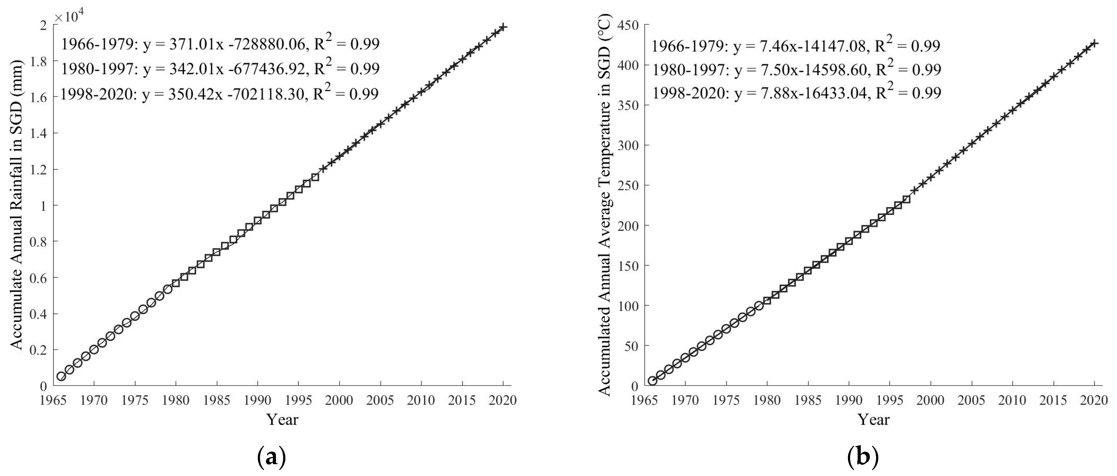
3.1. Characteristics of Changes in Hydrometeorological Elements in the Watershed Subsection

Figure 2 shows the changing trends of interannual water and sediment characteristic indicators in the Huangfuchuan River basin from 1966 to 2020. From the figure, it can be seen that the long-term average natural runoff at Huangfu Station is 1.01 × 10⁸ m3, while the long-term average runoff at Shagedu Station is 0.45 × 10⁸ m3. Overall, the annual runoff exhibits a fluctuating declining trend, with reduction rates of 0.034 × 10⁸ m3/yr and 0.017 × 10⁸ m3/yr, respectively. The annual runoff depth at Huangfu Station ranges from 0.006 to 137.32 mm, while, at Shagedu Station, it ranges from 0.1 to 152.48 mm, with average depths of 31.74 mm and 33.47 mm, respectively. The years in which the annual runoff depth of the two sub-basins exceeded the average were 23 years and 20 years, accounting for 41.82% and 36.36% of the entire statistical time series.
The changes in sediment load are similar to those in runoff. The long-term average sediment load at Huangfu Station is 0.32 × 10⁸ t, while, at Shagedu Station, it is 0.16 × 10⁸ t, both showing a significant decreasing trend with reduction rates of 0.014 × 10⁸ t/yr and 0.007 × 10⁸ t/yr, respectively. The sediment yield modulus, defined as the quantity of sediment generated per unit area of the basin over a specified time interval, serves as a critical metric for quantifying erosion and sediment yield within the basin. For the two hydrological stations under investigation, the annual sediment yield modulus was derived by computing the ratio of total sediment discharge to the basin area, based on the catchment area controlled by each station. The annual sediment yield modulus at Huangfu Station ranges from 0 to 48,503.94 t/km2, while, at Shagedu Station, it ranges from 0.12 to 59,757.34 t/km2, with an average sediment yield modulus of 9955.65 t/km2 and 12,178.79 t/km2, respectively. In the Huangfu basin, there are 29 years where the sediment yield modulus exceeds 5000 t/km2 (indicating strong erosion intensity), during which the total precipitation, total runoff, and total sediment load account for 66.19%, 88.39%, and 93.57% of the respective totals for the statistical years. At Shagedu Station, there are 33 years with sediment yield modulus exceeding 5000 t/km2, where the total precipitation, total runoff, and total sediment load account for 65.80%, 89.67%, and 95.03% of the respective totals for the statistical years. Thus, while the annual average precipitation in the Shagedu-controlled sub-basin is lower than that of the entire Huangfuchuan River basin, its annual average sediment yield modulus is greater by 2223.14 t/km2, indicating that areas above Shagedu with a significant distribution of sandstone are sources of erosion and sediment production in the basin.
Overall, the maximum annual runoff and sediment load values at both Huangfu and Shagedu Stations occurred in 1979, while the minimum values were recorded in 2011. Throughout the study period, the region is characterized as a sandy and coarse sediment area in the middle reaches of the Yellow River. It can be seen from Table 1, the coefficients of variation for interannual runoff at Huangfu and Shagedu Stations were 0.91 and 1.01, respectively, while the coefficients of variation for sediment load were 1.15 and 1.10, significantly higher than the coefficients of variation for annual precipitation (0.24 and 0.26). This indicates that the interannual variability of water and sediment in the basin is greater than that of precipitation. Since this basin is a major source of sediment in the Yellow River, the erosion and sediment production primarily result from high-intensity, concentrated precipitation during the flood season. Therefore, the greater variability in water and sediment compared to precipitation also reflects the influence of other factors (such as land use and cover patterns) on the changes in water and sediment in the basin during the study period, aside from climatic factors.
From Figure 3, it can be seen that, from 1966 to 2020, the annual precipitation and average annual temperature in the Huangfuchuan River basin were 372.39 mm and 8.01 °C, respectively, while, in the Shagedu sub-basin, the annual precipitation and average annual temperature were 359.07 mm and 7.79 °C, respectively. Overall, the precipitation and average annual temperature in the entire basin increased by approximately 0.25 mm and 0.032 °C per year. However, the precipitation in the Shagedu sub-basin showed a nonsignificant decreasing trend, with an annual decline of about 0.71 mm; meanwhile, the temperature increased by approximately 0.036 °C.
Using the Mann–Kendall trend test and the Spearman rank test for comparative analysis, the trend changes in the time series of annual precipitation, average annual temperature, annual runoff, and annual sediment load in the Huangfuchuan River basin at different spatial scales were examined. The results of the statistical tests for hydrometeorological elements are detailed in Table 2. It can be observed that the results identified by both testing methods are consistent. The Mann–Kendall trend analysis indicates that the Z statistics for annual runoff and sediment load at both hydrological stations are less than 0, with the absolute values of Z exceeding 1.96. This signifies that they have passed the 0.05 significance trend test, indicating that the runoff and sediment load in both sub-basins show a significant decreasing trend at the interannual scale. Among them, the annual runoff in the Huangfuchuan River basin has the greatest reduction, with an absolute Z statistic of 5.28, while the sediment load in the Shagedu sub-basin has the largest reduction, with an absolute Z statistic of 6.22. For the Huangfuchuan River, the annual precipitation and average annual temperature Z statistics are both above 0, with the absolute value of the average annual temperature statistic exceeding 1.96, indicating a significant upward trend. However, the absolute value of the precipitation statistic is less than 1.96, suggesting that the upward trend is not significant and lacks statistical meaning. The statistical value for average annual temperature in the Shagedu sub-basin is the highest, indicating a more significant upward trend. The results of the Spearman rank test are consistent with those of the Mann–Kendall test, with correlations for annual runoff, sediment load, and average annual temperature all exceeding 0.5, all passing the 0.05 significance level test. Notably, the Spearman rank test correlations in the Shagedu sub-basin are generally higher than those for the entire Huangfuchuan River basin.

3.2. Abrupt Change Characteristics of Water and Sediment at Different Spatial Scales in the Basin

A hydrological sequence is the result of the combined effects of climate conditions, natural geographic factors, and human activities over a certain period. Abrupt changes within the sequence indicate a transition from one state to another, signifying a fundamental shift in hydrological characteristics. As a key aspect of nonlinear variations, studying abrupt changes in runoff and sediment load sequences is crucial for understanding the evolution of the hydrological cycle under the influence of climate change and human activities. To account for potential discrepancies among different change-point detection methods and to ensure the reliability of results, this study employs multiple approaches, including the double cumulative curve method (Figure 4 and Figure 5), the cumulative anomaly method (Figure 6 and Figure 7), and the Pettitt test (Figure 8 and Figure 9), to identify abrupt change years in the annual runoff and sediment load sequences of the Huangfuchuan River basin. By integrating these methods and selecting the most significant change points, the final change points for annual runoff and sediment load in the basin are determined.
By analyzing the double cumulative curves of precipitation–runoff and precipitation–sediment load in the two sub-basins from 1966 to 2020, it was found that the slope of the curves changed significantly in 1979 and 1998. This indicates that the annual runoff and sediment load in the Huangfuchuan River basin experienced abrupt changes around these years. According to the results of the double cumulative curve method (Figure 4 and Figure 5), both the Huangfuchuan River basin and the upstream Shagedu sub-basin showed a decrease in the slope of the precipitation–runoff cumulative curve starting in 1979, with an even steeper decline after 1998. This suggests that the runoff gradually decreased throughout the study period. The annual sediment load followed a similar trend. Therefore, 1979 and 1998 are identified as the abrupt change points for runoff and sediment variations in the two sub-basins of the Huangfuchuan River basin.
However, due to the inherent subjectivity of the double cumulative curve method, it is essential to combine it with other methods for a comprehensive determination of the mutation points. To further identify the aforementioned mutation points, this study employs the cumulative anomaly method, with results presented in Figure 6 and Figure 7. The changes in the cumulative anomaly curve of annual runoff can be divided into three stages: from 1966 to 1979, there is a trend of fluctuating growth; from 1980 to 1997, there is a slight but not statistically significant increase, with the cumulative anomaly reaching its peak in 1998, after which the curve shows a clear downward trend. The trend of cumulative anomaly values for annual sediment yield aligns with that of annual runoff, with the maximum also occurring in 1998. Subsequently, the slope of the cumulative anomaly curve declines, and the fluctuations become less pronounced. Therefore, the cumulative anomaly values for annual runoff and annual sediment yield in the two sub-basins of the Huangfuchuan River both exhibit significant mutations in 1979 and 1998.
The core of the Pettitt nonparametric test method is to determine the exact timing of mean changes in time series elements under the premise of existing trends, allowing for the identification of the exact point of mutation. This method effectively avoids the interference of outliers and the influence of data distribution characteristics. Building on the double cumulative and cumulative anomaly methods, the Pettitt method was applied again to test for mutations in runoff and sediment yield in the two sub-basins. The test results indicate that the U values of the test statistics for the annual runoff and sediment load series of the two hydrological stations reached their maxima in 1998 and achieved a 99% confidence level, signifying a significant mutation point. This indicates that the runoff and sediment load time series in Huangfuchuan underwent a notable change in 1998. Therefore, based on the identification results from the three mutation tests (as shown in Table 3), the years 1979 and 1998 are determined to be the mutation points for runoff and sediment changes in the Huangfuchuan River basin from 1966 to 2020. The calculated mean runoff before and after the mutations at Huangfu Station were 182 million m3, 114 million m3, and 41 million m3, respectively. At Shagedu Station, the means were 89 million m3, 46 million m3, and 18 million m3. The sediment yield at Huangfu Station before and after the mutations was 65 million tons, 36 million tons, and 8 million tons, while, at Shagedu Station, it was 35 million tons, 18 million tons, and 4 million tons. Notably, in 1998, China implemented the Grain-for-Green ecological restoration project, which may be significantly related to the notable changes in the runoff and sediment yield slope in that year. To further study the runoff characteristics and influencing factors during different periods, the research area will be divided into three time periods: 1966–1979, 1980–1997, and 1998–2020 for subsequent studies.

3.3. Runoff–Sediment Relationship at Different Spatial Scales

Based on the time series of annual runoff and sediment transport in the Huangfuchuan River basin, the power function relationship between flow and sediment transport rate before and after the basin’s change point was plotted, as shown in Figure 10 (Figure 10a represents the entire basin and Figure 10b represents the upstream basin controlled by Shagedu). As shown in Figure 10, the determination coefficient (R2) of the power function relationship for both the entire Huangfuchuan basin and the upstream basin is 0.87, indicating a strong power function relationship between runoff and sediment transport in the Huangfuchuan River basin, with a good fitting result. In the water–sediment relationship curves for both the entire basin and the upstream basin, the factor a, which represents runoff and sediment production, is 0.24 for the entire basin and 0.37 for the upstream basin, while the factor b, representing the sediment transport capacity of the river, is 1.18 for the entire basin and 0.98 for the upstream basin. These results indicate that the upstream basin is more prone to runoff erosion, with a stronger capacity for runoff and sediment production compared to the entire basin, leading to higher sediment transport. However, the difference in b values is not significant, suggesting that changes in the river’s sediment transport energy, driven by internal channel factors, are not substantial within the basin.
Further analysis of the water–sediment relationship before and after the change point at the two spatial scales revealed that the water–sediment relationship for the entire basin was approximately linear from 1966 to 1979. This indicates that flow was the primary controlling factor of sediment transport during this period, and the basin was relatively less affected by human activities. The nonlinear enhancement of the water–sediment relationship from 1980 to 1998 indicates a significant increase in the dependence of sediment transport rate on flow rate. This is likely due to the fact that most of the silt dams in the basin, constructed in the 1970s, have a lifespan of 5 to 10 years. During this period, many of these dams were filled with sediment and subsequently failed, reducing their sediment retention capacity. Additionally, the sediment reduction and retention effects of forest and grass measures were much less effective than the engineering measures, leading to an increase in sediment transport within the basin. As a result, the influence of flow rate on sediment transport became more pronounced, and the water–sediment relationship showed a better fit. From 1999 to 2020, the water–sediment relationship became close to linear again but with a decrease in the goodness of fit, suggesting that the soil and water conservation measures implemented in the basin contributed to greater variability in the sediment transport rate. This increase in volatility indicates that the water–sediment relationship was more influenced by external factors during this period. In addition, for the upstream basin, the fitting equations were close to a linear relationship in all three time periods, with values higher than those of the entire basin, indicating a lower fitting effect. This suggests that runoff and sediment production in the upstream basin were relatively higher during all three stages and more influenced by environmental heterogeneity. This is likely due to the sparse vegetation and undulating terrain in the upstream basin, which made it more susceptible to sediment production under the same flow conditions.

3.4. Impacts of Climate and Human Activities on Water and Sediment Changes at Different Spatial Scales

The double cumulative curves of meteorological elements and water and sediment sequences in the two basins were plotted (Figure 11, Figure 12, Figure 13 and Figure 14). Based on Formulas (9) and (10), the cumulative slope change rates of water and sediment and climatic factors were calculated for three periods: the base period A (1966–1979), the change period B (1980–1997), and the change period C (1998–2020). The slope calculation results of the cumulative sequences at different stages and their corresponding change rates are presented in Table 4 and Table 5.
A positive slope change rate of a variable’s cumulative amount indicates an increasing trend over a specific period, while a negative slope signifies a declining trend. As shown in Figure 11 and Figure 12 and Table 4, the slope changes of the cumulative runoff and cumulative sediment load in the entire Huangfuchuan River basin are −0.44, −1.15 and −0.19, −0.5 in stages B and C. The slope change rates are −0.282, −0.737 and −0.34, −0.89, all of which are negative values, and the absolute value of the change rate in stage C is greater than that in stage B, indicating that the runoff and sediment load sequences have a continuous downward trend.
In contrast, the cumulative change and variation rate of mean annual temperature were positive, demonstrating a consistent warming trend. The slope change rate of cumulative precipitation is negative during stage B and turns positive in stage C, indicating a shift in the precipitation trend from a decline to a subsequent increase over time.
As shown in Figure 13 and Figure 14 and Table 5, the trends of cumulative runoff and cumulative sediment load in the sub-basin controlled by the Shagedu Station are consistent with those observed in the overall Huangfuchuan River basin, exhibiting a continuous decline over time. The slope change rate of the cumulative annual average temperature is positive, indicating a sustained rising trend. In contrast, the slope change rate of cumulative precipitation is negative, with a marked decrease in precipitation observed during stage B.
The contribution rates of various influencing factors to the changes in runoff and sediment load within the basin were calculated using Equations (11)–(13). As shown in Table 6, during the transition from period A to B, when considering only precipitation as the climatic factor, the contribution rates of climate change and human activities to the reduction in annual runoff in the entire Huangfuchuan basin are 21.77% (−0.0614/−0.282) and 78.23% (1–0.2177), respectively. Similarly, the contributions to the reduction in annual sediment load are 18.10% and 81.90%, respectively. In the B–C stage, the contribution rates of climate change and human activities to the reduction in annual runoff were 9.03% and 90.97%, respectively, while their contributions to the reduction in annual sediment load were 7.46% and 92.54%, respectively.
Taking into account both precipitation and temperature as the climatic factors, the contribution rates of climate change and human activities to the reduction in annual runoff in the Huangfuchuan River basin were 24.12% and 75.88% during the A–B stage, and 18.91% and 81.09% during the B–C stage. Similarly, the contribution rates to the reduction in annual sediment load were 20.05% and 79.95% in the A–B stage and 15.61% and 84.39% in the B–C stage. Notably, the impact of climate change and human activities on runoff reduction was stronger than their impact on sediment load reduction.
Table 7 shows that, during the A–B period of the change phase, when only the influence of precipitation as a single climatic factor is considered, the contribution rates of climate change and human activities to the reduction in annual runoff in the sub-basin controlled by Shagedu Station were 21.8% and 78.2%, respectively. Similarly, the contribution rates to the reduction in annual sediment load were 21.33% and 78.67%, respectively. In the B–C stage, the contribution rates of climate change and human activities to the reduction in annual runoff were 9.04% and 90.96%, respectively, while their contribution rates to the reduction in annual sediment load were 7.67% and 92.33%, respectively.
Considering both annual precipitation and average annual temperature as climatic factors, the contribution rates of climate change and human activities to the reduction in annual runoff in the Shagedu basin were 23.15% and 76.85%, respectively, during the A–B stage and 16.36% and 83.64%, respectively, during the B–C stage. Similarly, the contribution rates to the reduction in annual sediment load were 22.65% and 77.35% in the A–B stage and 13.89% and 86.11% in the B–C stage.
In summary, compared to the baseline period, human activities have been the primary driver of reduced runoff and sediment load in the basin. Moreover, after 1998, their impact on runoff and sediment reduction has become even more pronounced, indicating an increasing influence of human activities over time.

4. Discussion

4.1. Characteristics of Water and Sediment Changes in the Basin

This study analyzed data from two hydrological stations in the Huangfuchuan River basin and found that, during the study period, the sediment yield in the upstream sub-basin controlled by the Shagedu Station accounted for 52.05% of the total sediment yield in the entire basin, while its runoff accounted for 44.99%. This indicates that the upstream area is the primary sediment source of the basin. Moreover, the sediment load in the upstream region showed a more significant downward trend over time compared to the entire basin. Most previous studies have focused solely on data from the basin outlet at the Huangfu Station, with limited research on intra-basin water and sediment processes. Zou et al. [19] used the SWAT model to simulate the spatial distribution of water and sediment changes and found that sediment production in the upstream region was higher than in the downstream region. Additionally, the reduction in runoff and sediment yield was more pronounced in the upstream area, which was closely related to land use changes, such as the expansion of grassland and forested areas. The findings of this study align with these conclusions.
Accurately identifying abrupt changes in water and sediment dynamics within a basin is crucial for effective water resource management [36]. Numerous studies have investigated water and sediment variations in the Huangfuchuan River basin, and it has been consistently found that abrupt changes occurred in 1979 and 1998 across different spatial scales. For the entire basin, several studies have explored these changes. For instance, Zhao [37] and Tian [24,37] used the cumulative anomaly method to determine that the water and sediment shift occurred in 1979 and 1996 based on data from 1960 to 2010 and 1965 to 2010, respectively. Zhou et al. [38] applied sequential clustering, Pettitt’s test, and the Lee–Heghinian method to identify change points in runoff from 1956 to 2009, concluding that abrupt shifts occurred around 1979 and 1999. The slight discrepancies in timing may stem from differences in the time series analyzed. Therefore, the identification of two abrupt changes in this study is reasonable. The water–sediment relationship serves as an important indicator of soil erosion intensity and sediment yield within a watershed. In general, watersheds characterized by sparse vegetation, loose soils, and complex topography experience stronger surface erosion under conditions of rapid and high-volume runoff, resulting in greater sediment transport. Through analysis of the water–sediment relationship, this study found that the upstream watershed exhibits a lower fitting degree compared to the entire watershed, while the a value—representing runoff and sediment production—is higher. This confirms that the upstream watershed is the primary sediment source area of the entire basin, aligning with the findings of previous research.

4.2. Influencing Factors and Scale Effects of Water and Sediment Changes

This study applied the Slope Change Ratio of Accumulative Quantity (SCRAQ) method to compare the impacts of climate change and human activities on runoff and sediment load in the Shagedu and Huangfuchuan River basins. The results indicate that human activities are the dominant factor influencing water and sediment changes in both basins, with their contribution becoming even more significant in period B–C. Compared to runoff, human activities had a more pronounced effect on sediment load at both spatial scales, although the difference was not substantial. These findings align with those of Wang et al. [22], who first introduced this method to quantify the effects of precipitation and human activities on runoff variation in the Huangfuchuan River basin. However, Wang’s study considered only precipitation as a climate factor. This study expands on that by incorporating temperature, filling a gap in the application of this method for assessing climate contributions to water and sediment changes.
Precipitation is a crucial factor in the watershed hydrological cycle, directly influencing runoff and sediment erosion processes. Liu et al. [39] found that rising temperatures may lead to increased potential evapotranspiration, reducing runoff and ultimately affecting regional water balance. A comparative study at two spatial scales within the watershed revealed that the decreasing trends in runoff and sediment load were more pronounced than changes in precipitation and temperature. Figure 15 illustrates the relationship curves between precipitation, runoff, and sediment load in the two basins. It can be observed that the correlation between these variables gradually diminishes over time. The rainfall–runoff correlation for the entire basin decreases from 0.87 to 0.6, while the rainfall–sediment load correlation drops from 0.79 to 0.41. In contrast, the correlations in the upstream basin show (see Figure 16) a decline from 0.88 to 0.64 for rainfall–runoff and from 0.81 to 0.56 for rainfall–sediment load. Additionally, Table 7 indicates that, as temperature rises, its contribution to water and sediment variation increases, particularly during period B–C. This suggests that intensive human activities have significantly altered the watershed’s hydrological processes.
The Shagedu sub-basin, located in the upper reaches of the Huangfuchuan River basin, exhibits distinct hydrological and sediment load characteristics. The study results indicate that, despite receiving less precipitation than the entire watershed, the upper basin has a higher erosion modulus. Additionally, precipitation in the upper basin contributes more significantly to the reduction in runoff and sediment load compared to the entire watershed, with a particularly pronounced effect on sediment load. The precipitation–runoff and precipitation–sediment load relationship curves further demonstrate that the correlation between precipitation and runoff/sediment load in the upper basin is higher than that of the entire watershed across all three periods. The contribution of temperature to runoff and sediment reduction in the upper basin is lower than in the entire watershed, likely due to the extensive presence of Pisha sandstone in the upper basin. Storms serve as the primary driving force of erosion and sediment production in the Huangfuchuan River basin, with most storm centers occurring in the northwest of the watershed [40]. This region is characterized by Pisha sandstone soils with low infiltration rates, poor surface permeability, and limited water retention capacity. Furthermore, the area has sparse vegetation coverage, steep valley slopes, and high-intensity rainfall, leading to significant runoff generation. The rapid confluence of surface runoff results in concentrated flow and high sediment yield, making this region the most erosion-prone area within the watershed.
The above analysis indicates that, at different spatial scales, intensive human activities have been the dominant factor contributing to the significant reduction in runoff and sediment. Since the late 1950s, research and practical implementations in water conservation and soil retention have been carried out in the Huangfuchuan River basin. As shown in Figure 17, the cumulative controlled area of check dams at two spatial scales has changed over time. Initially, from 1962 to 1979, the cumulative controlled area of check dams in the Huangfuchuan River basin was 263.97 km2. By 1998, the number of check dams had increased to 176, controlling an area of 1106 km2, which accounted for 34.07% of the total basin area. The change point identified in the runoff and sediment time series (1998) aligns closely with the significant increase in check dam construction, indicating that check dams have played a crucial role in reducing runoff and sediment. By 2009, the total number of check dams in the basin had risen to 384, controlling an area of 1819 km2, which constituted 56% of the basin area. In the upstream region, check dam construction began later, around the 1980s, and, by 2009, 132 check dams had been built, controlling an area of 413.97 km2 or 31% of the sub-basin area. Research by Ran [40] et al. suggests that check dams can reduce sediment yield in a watershed by up to 60%.
In 1998, the Huangfuchuan River basin officially launched a major ecological restoration project, the “Grain for Green” program, to combat severe soil erosion and environmental degradation. Figure 18 illustrates the changes in the maximum NDVI at two spatial scales. From 1982 to 2020, the annual maximum NDVI in both the entire basin and the Shagedu sub-basin exhibited an increasing trend, with mean values of 0.33 and 0.27, respectively. By 2020, the forest and grassland coverage in the upstream region of Shagedu had reached 972.56 km2, while the entire basin had a total vegetation coverage of 2376 km2, accounting for 72% and 73% of their respective control areas. These vegetation restoration measures not only enhance rainfall interception and reduce evaporation but also improve soil infiltration. The root systems of plants slow down surface runoff, increase soil resistance to erosion, and ultimately decrease both surface runoff and sediment load capacity. According to research by Yang et al. [41], vegetation restoration efforts on the Loess Plateau have contributed to 47.7% of the sediment reduction since the increase in vegetation coverage began in 1996. Similarly, Bai et al. [42] found that vegetation measures accounted for 26.7% of sediment reduction in the Yellow River Basin. In summary, the combined effects of check dam construction and large-scale vegetation restoration were the primary drivers of the significant decline in runoff and sediment during the B–C period.
Overall, in recent years, the implementation of policies such as silt dam construction, returning farmland to forests, and ecological migration in the Huangfuchuan River basin has greatly changed the subsurface characteristics of the basin. This study clearly indicates that the dominant factors influencing changes in water and sediment in the Huangfuchuan River basin have gradually shifted from precipitation to human activities. In addition, our analysis at different spatial scales reveals that differences in lithology, geomorphologic and climatic characteristics, and land use changes in watersheds play an important role in the process of water–sand change, making a certain scale effect in the degree of contribution of water–sediment change and influencing factors. The findings offer valuable insights for further exploration and quantification of the impacts of various driving factors in future studies. Moreover, they provide a novel research direction for subsequent investigations within the basin. This research is of significant importance for the rational allocation of water resources and the management of soil erosion in the Loess Plateau region.

5. Conclusions

This study is based on hydrometeorological data from the Huangfuchuan River basin from 1966 to 2020, utilizing the Mann–Kendall nonparametric test and the Spearman rank test for trend analysis. Additionally, the double cumulative curve method, cumulative anomaly method, and Pettitt mutation test were employed to analyze the mutations in runoff and sediment. The cumulative quantity slope change rate method was used to assess the contributions of climate and human activities to the changes in runoff and sediment at two spatial scales in the Huangfuchuan River basin. The conclusions of this study can be summarized as follows:
(1)
From 1966 to 2020, the annual runoff and sediment yield in the entire Huangfuchuan River basin and the upper watershed controlled by Shagedu showed a significant decreasing trend (p < 0.05). The reduction rates for runoff were 0.034 × 10⁸ m3/yr and 0.017 × 10⁸ m3/yr, while the sediment yield decreased by 0.014 × 10⁸ t/a and 0.007 × 10⁸ t/a. The years of significant change in runoff and sediment yield for both scales occurred in 1979 and 1998, thus dividing the study period into three stages: 1966–1979, 1980–1997, and 1998–2020. The multi-year water–sediment relationship curves for both basins can be fitted using power function models; however, the fitting degree of the power function curve in the upstream basin is relatively lower, indicating greater variability and complexity in the runoff–sediment interactions in that region.
(2)
Compared to the baseline period, human activities are the primary reason for the reduction in runoff and sediment yield in both watersheds, and their impact on the decrease in runoff and sediment has been even more significant since 1998.
(3)
Due to differences in watershed topography and soil characteristics, the contribution rates of climate and human activities to the reduction in runoff and sediment yield vary across different watersheds and periods, demonstrating a scale effect. Specifically, compared to the baseline period, the impact of precipitation on runoff and sediment yield in the upper reaches of the watershed is greater than that in the entire watershed during the change period. In the A–B phase, the influence on sediment yield is particularly significant. However, in the B–C phase, the impact of temperature on the entire watershed outweighs that in the upper reaches, resulting in a lower contribution rate from human activities during this period. This also confirms that the influence of temperature on watershed runoff and sediment changes cannot be overlooked.
In summary, the variations in runoff, sediment load, and the water–sediment relationship within the basin are influenced by multiple interacting factors, exhibiting considerable uncertainty and complexity. Significant spatial heterogeneity in topographic relief, soil types, and vegetation cover exists throughout the basin. The overlapping erosion and deposition processes across different regions lead to a cumulative effect, whereby the water–sediment relationship observed at the basin outlet reflects the integrated influence of diverse factors operating across the entire watershed. There is a noticeable scale effect in both temporal and spatial dimensions. Moreover, the cumulative slope change rate method proves to be an effective tool for analyzing runoff and sediment dynamics, as well as their influencing factors, in arid and semi-arid basins. In addition, due to differences in spatial scale, erosion processes, sediment transport mechanisms, sediment sources, and composition, significant heterogeneity exists in the patterns and methodologies used to study basin erosion and sediment production. Future research endeavors should integrate diverse slope-scale experimental approaches with multi-scale and multi-method frameworks, ranging from point-scale to broader spatial extents. This integration will facilitate a comprehensive investigation into the mechanisms underlying runoff and sediment changes across different spatial and temporal scales, as well as the interactions between these scales. Additionally, further exploration of sediment transport dynamics within the watershed is essential to enhance our understanding of the complex hydrological processes. Such research will help determine the quantitative relationships and interactions between hydrological elements in the Huangfuchuan River basin. It will also provide a more comprehensive understanding of the runoff–sediment processes within the basin, thereby offering a more robust scientific basis for soil erosion control and basin planning and management.

Author Contributions

Conceptualization, F.Q. and Y.L.; methodology, X.D. and Y.L.; software, Y.L.; formal analysis, Y.L.; investigation, Y.L.; data curation, Y.L.; writing—original draft preparation, Y.L.; writing—review and editing, F.Q. and L.L.; supervision, L.L.; project administration, F.Q.; funding acquisition, F.Q., L.L. and X.D. All authors have read and agreed to the published version of the manuscript.

Funding

This research was funded by the “Evolution of Ecosystem Structure and Function and Its Impact on Water and Sediment Processes in the Watershed.” (Grant Number: 2022EEDSKJXM005-01), Inner Mongolia Autonomous Region Natural Science Fund—Study On the Hydraulic Erosion Process of Thin Overburden Arsenic Sandstone Slopes in Exposed Arsenic Sandstone Areas. (Grant Number: 2024QN03062) and National Natural Science Foundation of China-Pisha Sandstone Slope Erosion Spatio-temporal Variation and Vegetation Patch Pattern Evolution Mutual Feedback Mechanism. (Grant Number: 42267049).

Institutional Review Board Statement

Not applicable.

Informed Consent Statement

Not applicable.

Data Availability Statement

The original contributions presented in the study are included in the article; further inquiries can be directed to the corresponding author.

Conflicts of Interest

The authors declare no conflicts of interest.

References

  1. Smetanova, A.; Mueller, A.; Zargar, M.; Suleiman, M.A.; Gholami, F.R.; Mousavi, M. Mesoscale Mapping of Sediment Source Hotspots for Dam Sediment Management in Data-Sparse Semi-Arid Catchments. Water 2020, 12, 396. [Google Scholar] [CrossRef]
  2. Xu, Z.; Zhang, S.; Yang, X. Water and Sediment Yield Response to Extreme Rainfall Events in a Complex Large River Basin: A Case Study of the Yellow River Basin, China. J. Hydrol. 2021, 597, 126183. [Google Scholar] [CrossRef]
  3. Luan, J.; Zhang, Y.; Tian, J.; Meresa, H.; Liu, D. Coal Mining Impacts on Catchment Runoff. J. Hydrol. 2020, 589, 125101. [Google Scholar] [CrossRef]
  4. Wang, G.Q.; Zhang, J.Y.; Pagano, T.C.; Lin, J.L.; Liu, C.S. Identifying Contributions of Climate Change and Human Activity to Changes in Runoff Using Epoch Detection and Hydrologic Simulation. J. Hydrol. Eng. 2013, 18, 1385–1392. [Google Scholar] [CrossRef]
  5. Chang, J.; Wang, Y.; Istanbulluoglu, E.; Bai, T.; Huang, Q.; Yang, D.; Huang, S. Impact of Climate Change and Human Activities on Runoff in the Weihe River Basin, China. Quat. Int. 2015, 380, 169–179. [Google Scholar] [CrossRef]
  6. Yu, X.; Xie, X.; Meng, S. Modeling the Responses of Water and Sediment Discharge to Climate Change in the Upper Yellow River Basin, China. J. Hydrol. Eng. 2017, 22, 05017026. [Google Scholar] [CrossRef]
  7. Wang, H.; Lv, X.; Zhang, M. Sensitivity and Attribution Analysis Based on the Budyko Hypothesis for Streamflow Change in the Baiyangdian Catchment, China. Ecol. Indic. 2021, 121, 107221. [Google Scholar] [CrossRef]
  8. Hou, K.; Wang, J.; Wang, X. Characteristic and Attribution of Runoff Variation in the Yanhe River Basin, Loess Plateau, Based on the Budyko Hypothesis. Water 2022, 14, 495. [Google Scholar] [CrossRef]
  9. Wang, S.; Yan, M.; Yan, Y.; Shi, C.; He, L. Contributions of Climate Change and Human Activities to the Changes in Runoff Increment in Different Sections of the Yellow River. Quat. Int. 2012, 282, 66–77. [Google Scholar] [CrossRef]
  10. Cui, B.-L.; Chang, X.-L.; Shi, W.-Y. Abrupt Changes of Runoff and Sediment Load in the Lower Reaches of the Yellow River, China. Water Resour. 2014, 41, 252–260. [Google Scholar] [CrossRef]
  11. Ji, G.; Huang, J.; Guo, Y.; Yan, D. Quantitatively Calculating the Contribution of Vegetation Variation to Runoff in the Middle Reaches of Yellow River Using an Adjusted Budyko Formula. Land 2022, 11, 535. [Google Scholar] [CrossRef]
  12. Gao, P.; Mu, X.-M.; Wang, F.; Li, R. Changes in Streamflow and Sediment Discharge and the Response to Human Activities in the Middle Reaches of the Yellow River. Hydrol. Earth Syst. Sci. 2011, 15, 1–10. [Google Scholar] [CrossRef]
  13. Wang, J.; Cui, C.; Liu, M.; Huang, Z. Attribution Analysis of Runoff and Sediment Changes in the Yellow River Basin Based on the Budyko Framework. J. Water Clim. Chang. 2024, 15, 4901–4917. [Google Scholar] [CrossRef]
  14. Liu, F.; Chen, S.; Dong, P.; Peng, J. Spatial and Temporal Variability of Water Discharge in the Yellow River Basin over the Past 60 Years. J. Geogr. Sci. 2012, 22, 1013–1033. [Google Scholar] [CrossRef]
  15. He, Y.; Mu, X.; Jiang, X.; Song, J. Runoff Variation and Influencing Factors in the Kuye River Basin of the Middle Yellow River. Front. Environ. Sci. 2022, 10, 877535. [Google Scholar] [CrossRef]
  16. Yue, X.; Mu, X.; Zhao, G.; Shao, H.; Gao, P. Dynamic Changes of Sediment Load in the Middle Reaches of the Yellow River Basin, China and Implications for Eco-Restoration. Ecol. Eng. 2014, 73, 64–72. [Google Scholar] [CrossRef]
  17. Xin, Z.; Yu, B.; Han, Y. Spatiotemporal Variations in Annual Sediment Yield from the Middle Yellow River, China, 1950–2010. J. Hydrol. Eng. 2015, 20, 04014090. [Google Scholar] [CrossRef]
  18. Huang, X.; Qiu, L. Analysis of Runoff Variation and Driving Mechanism in Huangfuchuan River Basin in the Middle Reaches of the Yellow River, China. Appl. Water Sci. 2022, 12, 234. [Google Scholar] [CrossRef]
  19. Zuo, D.; Xu, Z.; Yao, W.; Jin, S.; Xiao, P.; Ran, D. Assessing the Effects of Changes in Land Use and Climate on Runoff and Sediment Yields from a Watershed in the Loess Plateau of China. Sci. Total Environ. 2016, 544, 238–250. [Google Scholar] [CrossRef]
  20. Yao, J.; Li, Z.; Yao, W.; Xiao, P.; Zhang, P.; Xie, M.; Wang, J.; Mei, S. The Compound Response Relationship between Hydro-Sedimentary Variations and Dominant Driving Factors: A Case Study of the Huangfuchuan Basin. Sustainability 2023, 15, 13632. [Google Scholar] [CrossRef]
  21. Wu, J.; Nunes, J.P.; Baartman, J.E.M.; Yang, D. Disentangling the Impacts of Meteorological Variability and Human Induced Changes on Hydrological Responses and Erosion in a Hilly-Gully Watershed of the Chinese Loess Plateau. Catena 2023, 233, 107478. [Google Scholar] [CrossRef]
  22. Wang, S.; Yan, Y.; Yan, M.; Zhao, X. Quantitative Estimation of the Impact of Precipitation and Human Activities on Runoff Change of the Huangfuchuan River Basin. J. Geogr. Sci. 2012, 22, 906–918. [Google Scholar] [CrossRef]
  23. Liang, Z.; Wu, Z.; Yao, W.; Noori, M.; Yang, C.; Xiao, P.; Leng, Y.; Deng, L. Pisha Sandstone: Causes, Processes and Erosion Options for Its Control and Prospects. Int. Soil Water Conserv. Res. 2019, 7, 1–8. [Google Scholar] [CrossRef]
  24. Tian, P.; Mu, X.; Liu, J.; Hu, J.; Gu, C. Impacts of Climate Variability and Human Activities on the Changes of Runoff and Sediment Load in a Catchment of the Loess Plateau, China. Adv. Meteorol. 2016, 2016, 4724067. [Google Scholar] [CrossRef]
  25. Baddoo, T.D.; Guan, Y.; Zhang, D.; Andam-Akorful, S.A. Rainfall Variability in the Huangfuchuang Watershed and Its Relationship with ENSO. Water 2015, 7, 3243–3262. [Google Scholar] [CrossRef]
  26. Liu, J.; Chen, L.; Zhang, D.; Pan, S.; Zhang, X. An Annual Sediment Yield Indicator Based on Precipitation—Vegetation Unmatched-Degree Developed in the Huangfu River Basin. Ecol. Indic. 2024, 166, 112584. [Google Scholar] [CrossRef]
  27. Zhang, B.; Wu, P.; Zhao, X.; Wang, Y.; Gao, X.; Cao, X. A Drought Hazard Assessment Index Based on the VIC-PDSI Model and Its Application on the Loess Plateau, China. Theor. Appl. Climatol. 2013, 114, 125–138. [Google Scholar] [CrossRef]
  28. Das, S.; Banerjee, S. Investigation of Changes in Seasonal Streamflow and Sediment Load in the Subarnarekha-Burhabalang Basins Using Mann-Kendall and Pettitt Tests. Arab. J. Geosci. 2021, 14, 946. [Google Scholar] [CrossRef]
  29. Tunde, O.L.; Adewole, O.O.; Alobid, M.; István, S.; Kassouri, Y. Sources and Sectoral Trend Analysis of CO2 Emissions Data in Nigeria Using a Modified Mann-Kendall and Change Point Detection Approaches. Energies 2022, 15, 766. [Google Scholar] [CrossRef]
  30. Masih, I.; Uhlenbrook, S.; Maskey, S.; Smakhtin, V. Streamflow Trends and Climate Linkages in the Zagros Mountains, Iran. Clim. Change 2011, 104, 317–338. [Google Scholar] [CrossRef]
  31. Jha, M.K.; Singh, A.K. Trend Analysis of Extreme Runoff Events in Major River Basins of Peninsular Malaysia. Int. J. Water 2013, 7, 142–158. [Google Scholar] [CrossRef]
  32. Mu, X.M.; Zhang, X.Q.; Gao, P.; Wang, F. Theory of Double Mass Curves and Its Applications in Hydrology and Meteorology. J. China Hydrol. 2010, 30, 47–51. [Google Scholar]
  33. Ran, L.; Wang, S.; Fan, X. Channel Change at Toudaoguai Station and Its Responses to the Operation of Upstream Reservoirs in the Upper Yellow River. J. Geogr. Sci. 2010, 20, 231–247. [Google Scholar] [CrossRef]
  34. Guo, E.; Bao, Y.; Bu, R.; Ren, Y.; Wang, Y. Assessing Spatiotemporal Characteristics of Drought Based on SPI in Mongolia Plateau. In Proceedings of the 8th Annual Meeting of Risk Analysis Council of China Association for Disaster Prevention (RAC 2018), Xi’an, China, 20–21 October 2018. [Google Scholar] [CrossRef]
  35. Cao, Q.; Zong, X.; Qi, C.; Yu, C.; Guo, J.; Shen, J.; Wei, S.; Wang, D.; Zhang, J.; Xia, J. Changes in Runoff and Sediment Loads in the Tuhai River Basin and the Factors Influencing These Changes. Water 2024, 16, 2064. [Google Scholar] [CrossRef]
  36. Zhang, J.; Wang, J.; Zhao, N.; Shi, J.; Wang, Y. Analysis of Changes in Runoff and Sediment Load and Their Attribution in the Kuye River Basin of the Middle Yellow River Based on the Slope Change Ratio of Cumulative Quantity Method. Water 2024, 16, 944. [Google Scholar] [CrossRef]
  37. Zhao, H.; Yang, S.; Yang, B.; Huang, Y. Quantifying Anthropogenic and Climatic Impacts on Sediment Load in the Sediment-Rich Region of the Chinese Loess Plateau by Coupling a Hydrological Model and ANN. Stoch. Environ. Res. Risk Assess. 2017, 31, 2057–2073. [Google Scholar] [CrossRef]
  38. Zhou, Y.; Shi, C.; Fan, X.; Shao, W. The Influence of Climate Change and Anthropogenic Activities on Annual Runoff of Huangfuchuan Basin in Northwest China. Theor. Appl. Climatol. 2015, 120, 137–146. [Google Scholar] [CrossRef]
  39. Liu, W.; Shi, C.; Zhou, Y. Trends and Attribution of Runoff Changes in the Upper and Middle Reaches of the Yellow River in China. J. Hydro-Environ. Res. 2021, 37, 57–66. [Google Scholar] [CrossRef]
  40. Ran, D.C.; Gao, J.L.; Zhao, A.C.; Wang, Y.C. Analysis on Runoff and Sediment Characteristics and Haunessing Measure in Huangfuchuan River Watershed. J. Hydraul. Eng. 2003, 2, 122–128. [Google Scholar]
  41. Yang, X.; Sun, W.; Li, P.; Mu, X.; Gao, P.; Zhao, G. Reduced Sediment Transport in the Chinese Loess Plateau Due to Climate Change and Human Activities. Sci. Total Environ. 2018, 642, 591–600. [Google Scholar] [CrossRef]
  42. Bai, R.; Wang, X.; Li, J.; Yang, F.; Shangguan, Z.; Deng, L. The Impact of Vegetation Reconstruction on Soil Erosion in the Loess Plateau. J. Environ. Manag. 2024, 363, 121382. [Google Scholar] [CrossRef] [PubMed]
Figure 1. Location of the research area. (a) The location map of the study area in China; (b) The geographic information of the study area.
Sustainability 17 04389 g001
Figure 2. Changes in annual runoff and sediment load at Huangfu station and Shagedu Station. (a) Huangfu Station; (b) Shagedu Station.
Sustainability 17 04389 g002
Figure 3. Changes in annual precipitation and average annual temperature in the basin. (a) Huangfu Station; (b) Shagedu Station.
Sustainability 17 04389 g003
Figure 4. Double accumulation curves of rainfall–runoff (a) and rainfall–sediment load (b) in the Huangfuchuan River basin.
Sustainability 17 04389 g004
Figure 5. Double accumulation curves of rainfall–runoff (a) and rainfall–sediment load (b) in the Shagedu Station control basin.
Sustainability 17 04389 g005
Figure 6. Cumulative anomaly diagram of runoff (a) and sediment load (b) in the Huangfuchuan River basin.
Sustainability 17 04389 g006
Figure 7. Cumulative anomaly diagram of runoff (a) and sediment load (b) in the Shagedu Station control basin.
Sustainability 17 04389 g007
Figure 8. Pettitt test diagram of runoff (a) and sediment load (b) in the Huangfuchuan River basin.
Sustainability 17 04389 g008
Figure 9. Pettitt test diagram of runoff (a) and sediment load (b) in the Shagedu Station control basin.
Sustainability 17 04389 g009
Figure 10. Temporal variations in the water–sediment relationship in the basin. (a) Huangfu Station; (b) Shagedu Station.
Sustainability 17 04389 g010
Figure 11. Cumulative curves of annual rainfall (a) and annual average temperature (b) in the Huangfuchuan River basin.
Sustainability 17 04389 g011
Figure 12. Cumulative curves of annual runoff (a) and annual sediment load (b) in the Huangfuchuan River basin.
Sustainability 17 04389 g012
Figure 13. Cumulative curves of annual rainfall (a) and annual average temperature (b) in the Shagedu Station control basin.
Sustainability 17 04389 g013
Figure 14. Cumulative curves of annual runoff (a) and annual sediment load (b) in the Shagedu Station control basin.
Sustainability 17 04389 g014
Figure 15. Correlations between precipitation–runoff (a) and precipitation–sediment load (b) at Huangfu Station before and after the mutation.
Sustainability 17 04389 g015
Figure 16. Correlations between precipitation–runoff (a) and precipitation–sediment load (b) at Shagedu Station before and after the mutation.
Sustainability 17 04389 g016
Figure 17. The cumulative controlled area of the silt dams in the basin has changed over time. (a) Huangfu Station control basin; (b) Shagedu Station control basin.
Sustainability 17 04389 g017
Figure 18. Annual NDVI value variation over time in the basin. (a) Huangfu Station control basin; (b) Shagedu Station control basin.
Sustainability 17 04389 g018
Table 1. Annual mean values and coefficients of variation of hydrological elements.
Time IntervalRainfall (mm)Runoff (108 m3)Sediment (108 t)
Multiyear AverageCoefficient of VariationMultiyear AverageCoefficient of VariationMultiyear AverageCoefficient of Variation
SGD359.070.260.451.010.161.10
HF372.390.241.010.910.321.15
Note: SGD represents the Shagedu-controlled basin and HF represents the Huangfu-Station-controlled basin.
Table 2. Trend test table for hydrological elements.
Hydrological ElementsMann–Kendall Trend Test (HF)Mann–Kendall Trend Test (SGD)Spearman Rank Test (HF)Spearman Rank Test (SGD)
Annual runoff −5.28−5.25−0.669−0.674
Annual sediment yield−5.87−6.22−0.75−0.78
Annual precipitation0.57−0.980.074−0.12
Annual average temperature 4.785.350.670.73
Table 3. Results of different test methods.
Hydrological StationHydrological
Elements
Test Method
Double Cumulative CurveCumulative Deviation MethodPettitt
Shagedu StationAnnual runoff1979, 19981979, 19981998
Annual sediment load1979, 19981979, 19981998
Huangfu StationAnnual runoff1979, 19981979, 19981998
Annual sediment load1979, 19981979, 19981998
Table 4. The slope change rate of cumulative precipitation, temperature, runoff, and sediment load in the Huangfuchuan River basin during each change period.
TimeAnnual Cumulative PrecipitationCumulative Annual Average TemperatureAnnual Cumulative RunoffAnnual Cumulative Sediment Load
HFSlopeΔSΔS/SSlopeΔSΔS/SSlopeΔSΔS/SSlopeΔSΔS/S
1966–1979A375.27 7.55 1.56 0.56
1980–1997B352.23−23.04−0.06147.600.050.0071.12−0.44−0.2820.37−0.19−0.34
1998–2020C400.2524.980.0678.100.550.0730.41−1.15−0.740.06−0.5−0.89
Table 5. The slope change rate of cumulative precipitation, temperature, runoff, and sediment load in the Shagedu Station control basin during each change period.
TimeAnnual Cumulative PrecipitationCumulative Annual Average TemperatureAnnual Cumulative RunoffAnnual Cumulative Sediment Load
SGDSlopeΔSΔS/SSlopeΔSΔS/SSlopeΔSΔS/SSlopeΔSΔS/S
966–1979A374.46 7.46 0.78 0.32
1980–1997B342.01−32.45−0.0877.500.040.0050.47−0.31−0.4000.19−0.13−0.41
1998–2020C348.42−26.04−0.0707.880.420.0560.18−0.6−0.770.03−0.29−0.91
Table 6. Contribution of climate change and human activities to runoff and sediment changes at Huangfuchuan River basin.
HFTimeAnnual Precipitation Average Annual TemperatureClimate FactorsHuman Activities
Annual runoffA–B21.77%2.35%24.12%75.88%
B–C9.03%9.88%18.91%81.09%
Annual sediment loadA–B18.10%1.95%20.05%79.95%
B–C7.46%8.16%15.61%84.39%
Table 7. Contribution of climate change and human activities to runoff and sediment changes at Shagedu Station control basin.
SGDTimeAnnual Precipitation Average Annual TemperatureClimate FactorsHuman Activities
Annual runoffA–B21.80%1.35%23.15%76.85%
B–C9.04%7.32%16.36%83.64%
Annual sediment loadA–B21.33%1.32%22.65%77.35%
B–C7.67%6.21%13.89%86.11%
Disclaimer/Publisher’s Note: The statements, opinions and data contained in all publications are solely those of the individual author(s) and contributor(s) and not of MDPI and/or the editor(s). MDPI and/or the editor(s) disclaim responsibility for any injury to people or property resulting from any ideas, methods, instructions or products referred to in the content.

