1. Introduction
The Loess Plateau is the most concentrated and extensive loess region on Earth, characterised by a fragile ecosystem. However, due to hydraulic erosion, the plateau surface is gradually shrinking. The region’s complex terrain—interwoven gullies, undulating ridges and plateaus, fragmented landscapes, steep slopes, and exposed loess—leads to severe soil erosion [
1]. The Dongzhi Plateau, situated in the middle reaches of the Yellow River, represents the most concentrated loess plateau globally and is a major sediment source for the Yellow River. It is one of China’s most severely eroded areas and is a critical base for energy and chemical industries [
2,
3]. However, population growth and over-exploitation have exacerbated erosion, placing the Dongzhi Plateau at risk of shrinkage and eventual disappearance.
Gully Consolidation and Highland Protection (GCHP) is an effective measure for comprehensive soil and water conservation in loess gully regions, playing a vital role in ecological restoration and sustainability [
4]. Exploring comprehensive management models for GCHP is crucial to improving the regional ecological environment, promoting integrated erosion control, and supporting sustainable socio-economic development.
GCHP represents a significant initiative for soil and water conservation tailored to the unique geomorphology and erosion conditions of the Loess Plateau. Lacking international precedents, early approaches primarily focused on gully slopes and valleys, employing terrace construction, afforestation, and check dam installations. The integration of slope and gully treatments, mainly through watershed-scale management in the 1990s, enhanced these efforts [
5,
6,
7]. However, limited attention was given to plateau surface erosion. Over the past six decades, research by water conservation, hydrology, and agricultural institutions has refined the concept of “gully stabilisation–slope protection–terrace conservation”, resulting in various comprehensive measures [
8].
Renowned researchers, including Zhu Xianmo [
9], have significantly contributed to understanding the geomorphological evolution, crustal stability, and hazard development of the Loess Plateau. Others, such as Zhang Xinbao et al. [
10,
11], have advanced the study of the region’s tectonic context, geological disaster distribution, and causation. While these studies have provided valuable insights and data, they often focus on soil and water conservation rather than the spatial-temporal dynamics and risk assessments specific to GCHP projects. Safety evaluations, secondary geological hazard activity, distribution characteristics, and risk assessments related to gully erosion and engineering geology remain underexplored. The lack of integration between hydraulic erosion mechanisms and engineering geology limits the effectiveness of existing models for GCHP projects.
Previous studies have seldom integrated engineering geology, hydrogeology, and ecological restoration into a unified management framework, leading to fragmented and suboptimal mitigation strategies. In contrast, this study introduces GCHP which systematically incorporates multi-disciplinary insights to enhance erosion control and land stability. The existing body of research on GCHP has predominantly focused on soil and water conservation strategies, emphasising slope stabilisation, terrace construction, afforestation, and check dam installations. While these approaches have contributed to erosion control, they have largely overlooked the plateau surface shrinkage and the underlying mechanisms driving deep-seated hydraulic erosion. By leveraging experimental and simulation data from the Dongzhi Plateau, the method constructs a comprehensive risk assessment model that accounts for hydraulic erosion dynamics, secondary geological hazards, and long-term ecological responses. This integrated approach addresses existing knowledge gaps and improves the practical implementation of GCHP by developing a scientifically informed, sustainable engineering framework that enhances both land use efficiency and ecosystem resilience.
These issues stem from unresolved mechanisms of deep-seated erosion, unclear hydrological and ecological responses [
12,
13], and inefficient resource allocation. As the ecological protection and high-quality development of the Loess Plateau gain prominence as national priorities, there is an urgent need to develop scientific management strategies for GCHP under the dual influences of climate change and intensive human activity.
Based on experimental and simulation data from the Dongzhi Plateau, this study identifies key issues in GCHP and proposes the “Sustainable Natural Gully Consolidation and Highland Protection Management Method”. The study systematically explores this method through four aspects: scientific challenges, methodological framework, core scientific principles, and practical applications. This research aligns with and directly supports China’s ecological and sustainability strategies, notably the Yellow River Basin Ecological Protection and High-Quality Development Initiative, which emphasises soil conservation, sustainable water resource management, and the restoration of degraded landscapes. Additionally, this study provides a replicable framework for mitigating land degradation, enhancing climate resilience, and promoting sustainable development in fragile ecosystems worldwide.
2. Materials and Methods
2.1. Study Area
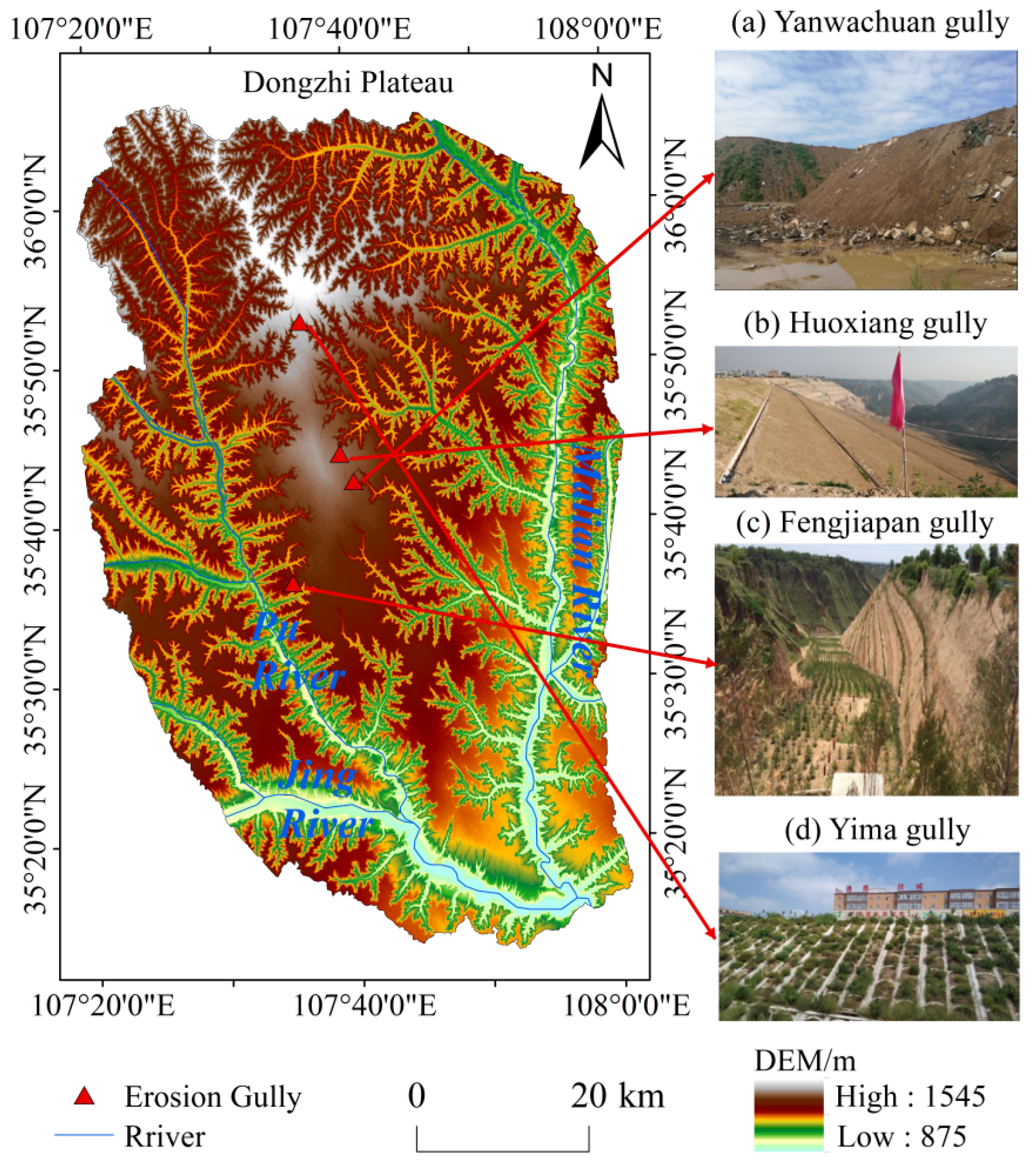
As the largest residual loess plateau in China, the Dongzhi Plateau has long been a focus of academic research due to its geomorphological evolution and soil erosion issues. The Dongzhi Plateau (
Figure 1) is located between 107°27′42″–107°52′48″ E and 35°25′55″–35°51′11″ N, stretching approximately 47.7 km in length and 34.8 km in width, with a total area of 996.35 km
2. It serves as the political, economic, and cultural centre of Qingyang City. The plateau surface, where the Xifeng District is situated, is a natural green agricultural production base known as the “Granary of Eastern Gansu” and the “Pearl of Longdong”.
The plateau surface covers 812 km2, accounting for 3.3% of Qingyang City’s total area, with a total cultivated land area of 1.0728 million mu. It is flat and slightly inclined to the southeast, extending 110 km from north to south. Its width ranges from approximately 50 km at its widest point to as narrow as 50 m. Located deep inland and far from the ocean, the Dongzhi Plateau lies in an arid to semi-arid region, with an average annual temperature of 8.6 °C and annual precipitation ranging from 480 to 660 mm. Precipitation distribution varies spatially, being higher in the southeast than in the northwest, and temporally, with most rainfall concentrated between May and September.
Due to its unique geographical location and terrain, the Dongzhi Plateau forms an independent hydrogeological unit with distinct recharge and discharge conditions. Atmospheric precipitation is the sole recharge source for the unconfined aquifer. Groundwater typically flows from the central highlands of the plateau toward its edges at a slow rate, with horizontal permeability of the aquifer ranging between 0.02 and 2.01 m/d. Discharge occurs mainly through natural springs and anthropogenic extraction.
The plateau’s vegetation is primarily dominated by crops, with vegetation distribution corresponding to regional precipitation patterns. The southern humid zone has better vegetation cover, while the northern arid zone is sparsely vegetated. The soil, primarily black loessial soil, exhibits slight variation across the plateau. The Dongzhi Plateau lacks developed river systems. It is surrounded by multiple gullies and tributaries, with the Maling River, Jing River, Pu River, and smaller streams like the Caijiamiao Gully and Jiaozichuan cutting into its edges. The elevation difference between the rivers and the plateau surface ranges from 250 to 300 m.
Numerous small tributaries heavily dissected and eroded the plateau’s surroundings [
14]. The Maling River, located on the eastern side of the Dongzhi Plateau, is the largest in Qingyang City. The Pu River, on the western side, is a primary tributary of the Jing River.
Table 1 provides details about the foundational data sources for this study.
2.2. Data Collection and Preprocessing Procedures
Meteorological data were obtained from the weather station installed by the Institute of Earth Sciences, Chinese Academy of Sciences, in the Nanxiaohegou watershed. Land use maps and related parameters were derived using ArcGIS 10.8 software, based on field surveys and high-altitude UAV imagery. Soil samples were collected from Yangjiagou and Dongzhuangou, and laboratory experiments were conducted to determine soil parameters. These results were further validated using existing reports and the Soil Chronicle of Qingyang to confirm soil types. Topographic data were vectorised using GIS software from scanned 1:50,000 contour maps. Observed runoff data were obtained from field measurements conducted in Yangjiagou and Dongzhuangou in 2018.
We employed data cleaning, spatial alignment, format conversion, and interpolation to ensure that all datasets remained consistent across spatial and temporal scales. Additionally, the data were standardised and normalised to eliminate discrepancies between different data sources, ensuring the reliability of the analysis results. During the data integration phase, all datasets were consolidated onto the GIS platform, where spatial analysis and modelling were conducted for in-depth research. This process not only enhanced the precision and integrity of the data but also provided a solid foundation for subsequent hydrological analysis and environmental assessment.
2.3. Research Methods
2.3.1. Ground Surveys
Field investigations were conducted intermittently from 13 July 2018 to 30 September 2024, spanning approximately seven years. The survey covered regions including Xifeng District, Ning County, Heshui County, and Qingcheng County. Using field visits and interviews as the primary methods, this study was supported by detailed plans for implementing gully stabilisation and plateau preservation projects provided by the Qingyang City Water and Soil Conservation Bureau. Additional data such as local meteorological records, runoff statistics, socio-economic data, and the extent of soil erosion were utilised.
Specific site visits were made to areas experiencing advancing gully heads. The investigation evaluated the current protective measures within the gully stabilisation and plateau preservation projects. Techniques such as remote sensing interpretation, unmanned aerial vehicle (UAV) surveys, and on-site field inspections were employed to examine and analyse the topography, geomorphology, and hydrological conditions surrounding gully heads.
This study aimed to identify the types, patterns, and driving mechanisms of gully head retrogressive erosion in the Dongzhi Plateau region, mainly focusing on the relationship between such erosion and human engineering activities. During rainfall events, observations of runoff convergence within gully head areas were conducted to analyse the runoff generation and accumulation phenomena in catchment areas.
Data analysis revealed that soil and water loss accounted for over 95% of the total area in almost every gully system. Remediation efforts covered less than 50% of the affected regions (Qingyang City Water and Soil Conservation Bureau, 2014).
2.3.2. Methods of Hydrological Analysis
By extracting basic hydrological factors and performing fundamental hydrological analyses, the flow process of surface water can be simulated on top of the DEM. This supports the analysis of where surface water originates and its path, allowing for the extraction of more hydrological information from the DEM data and ultimately completing the watershed hydrological analysis process.
The D8 algorithm was primarily used for the hydrological analysis. The D8 algorithm is one of the most widely applied techniques for watershed feature extraction based on flow direction and accumulation analysis [
15]. The D8 algorithm is a commonly used method for extracting watershed features by analysing the flow direction in terrain data, such as DEM. It assigns a flow direction to each pixel, indicating the direction of water flow toward the steepest slope among the eight neighbouring pixels. The algorithm calculates the elevation difference between a pixel and its eight surrounding neighbours, selects the direction with the steepest slope as the flow direction, and encodes each direction with a number (e.g., 1 for East, 2 for Southeast;
Figure 2). If multiple neighbours have the same steepest slope, the algorithm expands the search until a unique steepest direction is found.
Flow accumulation calculation: this process aims to determine the flow paths. A flow accumulation raster is generated based on the flow direction raster.
Watershed feature extraction: with the flow accumulation raster, it becomes easier to extract various watershed features, such as simulating the watershed’s drainage network and calculating key parameters such as river length, slope, and watershed area.
The GIS-based hydrological analysis consists of three key steps: terrain preprocessing, hydrological parameter extraction, and watershed modelling. First, DEM data are used for terrain preprocessing, including depression filling, flow direction calculation, and watershed delineation to ensure continuity in water flow paths. Second, hydrological parameters such as slope, flow accumulation, and drainage density are extracted to quantify the impact of topography on hydrological processes. Finally, by integrating the GeoWEPP model, the GIS platform simulates the rainfall-runoff process within the watershed, assessing the effects of various soil and water conservation measures on runoff and erosion. This approach provides a scientific basis for water resource management and watershed conservation planning.
The flow threshold used for hydrological delineation in this study was determined by the flow accumulation of each raster cell. Through comparative analysis of our results with actual field survey data and high-resolution remote sensing imagery, we calibrated the flow threshold to ensure that the stream network density was closely aligned with the distribution observed in the remote sensing images, resulting in an optimal balance. The final threshold was selected to guarantee that the delineated sub-basins accurately represent the natural drainage patterns and erosion-prone areas within the study region.
This study used hydrological analysis to calculate the range and area of each catchment in which erosion occurs. We classified the Xifeng District into 1225 catchment areas, with the largest catchment area, numbered 509, having an area of 6.063 km2.
2.3.3. GeoWEPP Simulation Results Evaluation Method
The GeoWEPP model was employed to simulate the runoff and soil erosion processes in the study area. The GeoWEPP model consists of three main modules: TOPWEPP, TOPAZ, and CLIGEN. The TOPWEPP module extracts soil properties, land use types, and vegetation information from soil and land use distribution maps. The TOPAZ module processes elevation data to generate the terrain parameters the model requires. The CLIGEN module is used to generate climate data essential for model simulations. The technical workflow of the GeoWEPP model is presented in
Figure 2.
The model was calibrated using soil parameters, and the evaluation of the simulation results was based on three key indicators: the correlation coefficient (R2), relative error (Re), and Nash–Sutcliffe efficiency (ME) coefficient. These indicators assess how well the simulated results match the observed data, which is a crucial step before interpreting the model’s predictions.
R2 (Correlation coefficient) quantifies the strength of the relationship between the observed and simulated runoff data.
Re (Relative error) measures the model’s accuracy by comparing the simulated and observed values.
ME (Nash–Sutcliffe efficiency) indicates the model’s overall performance, where values close to 1 suggest good predictive power.
The formulas for the calculation of the correlation coefficient
R2, relative error
Re, and Nash–Sutcliffe coefficient
are as follows:
where
is the correlation coefficient;
is the sample size (the same applies in subsequent formulas); and where
represent the observed data and the simulated data, respectively. The larger the correlation coefficient, the stronger the correlation between the observed and simulated data. Conversely, a smaller correlation coefficient indicates a weaker correlation.
where
is the relative error,
is the simulated value, and
is the observed value (the same applies in subsequent formulas).
where
is the average observed value. When
, the
ME is equal to 1. The closer
ME is to 1, the higher the model’s efficiency. If
ME is negative, it indicates that the model’s simulation of the average value is less reliable than directly using the observed average value.
2.3.4. Coupled GeoWEPP-GCHP Workflow for Iterative Simulation and Design in Sustainable Gully Stabilisation
Based on the established GeoWEPP model, we conducted watershed-scale hydrological and erosion simulations to identify high-risk zones and key erosion pathways, providing quantitative support for the design of GCHP engineering measures. Simulation results were used to determine risk levels and prioritise intervention areas, enabling the scientific delineation of treatment zones and engineering layouts. Considering regional characteristics and model-informed recommendations, various control measures were designed under different scenarios to form multiple engineering combinations. These proposed scenarios were re-input into the GeoWEPP model for multiple rounds of simulation, allowing comparative analysis of runoff and sediment responses under different conditions to verify their effectiveness. By iteratively refining engineering schemes based on model outputs, a bidirectional coupling mechanism of “simulation-guided design—design-informed simulation” was achieved, ultimately identifying the optimal management strategy. The overall workflow was illustrated in
Figure 3.
2.4. Historical Development of Soil Erosion in Dongzhi Plateau
Dongzhi Plateau in Qingyang, Gansu Province, is the world’s largest and most intact loess plateau, known as the “First Loess Plateau in the World”. It supports the survival and development of 610,000 people in the plateau area [
16]. Human activities have intensified since the Qin and Han Dynasties, leading to increased upstream erosion at the edges of the plateau. The once intact plateau surface has been gradually fragmented [
17]. The annual average erosion modulus is 6898 t/km
2.a, with the primary erosion types being hydraulic, gravitational, and freeze–thaw erosion [
18]. Soil erosion consumes agricultural land at an average annual rate of 42 hm
2, and approximately 48.09 million tons of sediment enter the Yellow River each year [
19].
The current area of the plateau has been reduced to 756 km
2, losing 2/3 to 3/4 of its original surface (
Figure 1). Currently, 13 large ravines converge towards the centre of the plateau, rapidly eroding the surface and fragmenting it into multiple pieces. More than 2000 gullies have a height of over 1000 m, making the plateau a landscape of thousands of ravines, continually cut and fragmented [
17,
20]. Many areas risk collapse or disappearance, severely impacting the safety of urban and rural production and living conditions [
21]. In modern times, the Dongzhi Plateau has experienced rapid population growth. As human activities intensified, the erosion front has advanced, and the plateau has shrunk. Water shortage remains a critical factor limiting ecological construction in the region [
22].
Simultaneously, with the frequent occurrence of extreme weather events in the northwest, numerous ravines surround the plateau, constantly advancing towards its centre [
23]. Human activities have intensified in recent decades with population growth and accelerated urbanisation. The surface hardening has reduced infiltration, leading to rapid fluctuations in water flow in the ravines, exacerbating soil erosion. This has led to the fragmentation of the plateau, with some sections even beginning to disintegrate, posing a serious threat to urban and rural construction. The disintegration of the loess plateau is caused by erosion, but massive landslides accompany the process and collapse. This phenomenon is widespread in loess areas and has severe consequences. Soil erosion and geological disasters, such as landslides, collapses, and mudflows, often reinforce one another. Erosion in the ravines leads to landslides and collapses, exacerbating erosion, representing the main manifestation and mechanism of geomorphological and disaster processes on the Loess Plateau [
24].
3. Results and Analysis
Based on hydrological analysis methods, we divided the study into 1225 sub-basins in
Figure 4.
3.1. GeoWEPP Simulation and Model Validation: Quantitative Assessment of Runoff and Soil Erosion
This study utilised the GeoWEPP model to simulate runoff and soil erosion within the study area. The simulation results of GeoWEPP provide a spatial targeting basis for the engineering design of the GCHP by identifying high erosion risk areas, such as the concentrated zones of slope surface runoff and the areas of headcut retrogressive erosion. The results were compared with observed data to assess the model’s reliability and applicability. The simulation results indicated significant spatial variations in runoff and soil erosion across different catchments. The model’s performance was evaluated using measured data, with key assessment indicators presented as follows (
Table 2).
These results suggest that the GeoWEPP model effectively captures the hydrological characteristics of the study area, although some discrepancies remain in soil erosion simulations.
We evaluated the applicability of the model in the study area by calibrating and validating it at the event scale using 13 runoff events. The comparison between the simulated and observed runoff depths during the calibration and validation periods is shown in
Figure 5. The simulated runoff depths exhibit a consistent trend with the measured values, with minimal errors, indicating the model’s reliability in runoff simulation.
3.2. Overview of GCHP Engineering Models and Practices: Integrating Hydrological and GIS-Based Analyses
Land consolidation practices inspired the GCHP ecological engineering system in the 1950s in the South Xiaogou region [
25]. This system has proven effective in controlling soil erosion and protecting and restoring the ecosystem [
26]. Based on field surveys and analysis, the main “GCHP” engineering models in the Loess Plateau are as follows:
Simple Landfill Model (e.g., Yanwanchuan).
Drainage + Landfill Model (e.g., Huoxiangou).
Drainage + Landfill + Slope Protection Model (e.g., Fengjiapan Gully).
Drainage + Landfill + Slope Protection + Ecological Measures Model (e.g., Yimadagu).
The typical locations of the gully and the main engineering measures are detailed in
Figure 1.
3.2.1. Simple Landfill Model
The simple landfill method is the most common engineering measure in the Dongzhi Plateau, and it is divided into two approaches: direct dumping and compaction. The fill materials are primarily of two types: (i) loess from other areas; (ii) mixed loess and waste from urban construction or daily life.
For example, in the Yanwanchuan watershed (
Figure 1a, taken in May 2018), the gully head treatment adopted direct dumping of mixed urban waste and loess. Direct landfill of waste is the most common practice in Qingyang. This method saves costs and indirectly addresses urban waste disposal issues. However, this method has drawbacks: the fill materials are not artificially solidified and are dumped into the gully. The surface soil and waste are exposed, making them vulnerable to erosion from rainwater, which could also lead to secondary groundwater pollution.
3.2.2. Drainage + Landfill Model
The drainage + landfill model is also a commonly used treatment method. Drainage structures typically include cantilever-type waterfalls, steep-slope type, and stepped drainage mixed water protection structures, as seen in the Huoxiangou watershed (
Figure 1b, taken in May 2018). The treatment in Huoxiangou is a typical example of a “GCHP” project. This method involves constructing a transverse drainage channel above the landfill, allowing runoff to flow into the gully after gathering. While this model can help reduce surface runoff erosion, it has some design flaws. The drainage structures, especially in water diversion and structure selection, have not been precisely calculated according to hydrological and topographical conditions. Furthermore, groundwater erosion issues have not been addressed, which could lead to gravity-induced erosion and cause the landfill to collapse from the base, ultimately leading to failure.
3.2.3. Drainage + Landfill + Slope Protection Model
This model builds upon the drainage + landfill method and adds slope protection on both sides of the gully. First, blind drainage pipes are installed at the gully head to direct runoff down the gully. An energy dissipation pool is placed at the gully bottom to prevent direct hydraulic erosion. The gully head is then backfilled and compacted. Finally, slope protection measures, such as dry-stone masonry or concrete masonry, are constructed on both sides of the gully to reduce the load on the slope (e.g., Fengjiapan Gully,
Figure 1c, taken in May 2018). This method strengthens the soil on the slopes to prevent further erosion. Compared to the second model, slope protection helps intercept rainfall, reduce splash erosion, and better protect the landfill soil. However, this method is more expensive due to the higher construction material and labour costs.
3.2.4. Drainage + Landfill + Slope Protection + Ecological Measures Model
Ecological slope protection is a technique that integrates basic knowledge from engineering mechanics, soil science, ecology, and botany to support the slope, forming a comprehensive protection system composed of both engineering and plant-based solutions. This model involves planting vegetation after filling the gully, using the interaction between plants and the soil (root anchoring) to protect and reinforce the surface layer of the slope. Ecological slope protection reduces the pore water pressure in the landfill soil, intercepts rainfall, and helps restore the damaged natural ecosystem. This is an effective method for “GCHP” (e.g., Yimadagu,
Figure 1d, taken in May 2018). Based on field surveys, this model has shown the most significant protective effects, with marked improvement in gully erosion conditions. However, due to the lack of water resources and arid conditions in the Loess Plateau, planting and maintaining vegetation is difficult and costly.
3.3. Comparative Analysis of Erosion and Sediment Yield Simulations: Original State vs. GCHP Scenarios (Gully Head Landfill, Slope Terracing, and Sediment Retention Dam) with GIS and DEM-Based Hydrological Insights
Using the GeoWEPP model, erosion and sediment yield simulations were conducted for the typical gully Yangjiagou in Dongzhi Plateau, Gansu Province, under three scenarios of GCHP engineering (gully head landfill, slope terracing, and sediment retention dam). The simulations compared the runoff and sediment yield in the watershed under different scenarios. The results showed that for small watersheds with GCHP measures, runoff and sediment yield were reduced under secondary rainfall conditions. This indicates that, under such conditions, the GCHP engineering measures play a positive role in controlling hydraulic erosion.
The boxplot (
Figure 6) shows that under secondary rainfall conditions, the three GCHP engineering scenarios show significant and clear trends in reducing runoff and sediment yield.
In terms of reducing runoff, the slope terracing scenario in Yangjiagou has the largest reduction percentage (41.59%), followed by the sediment retention dam (29.6%) and the gully head landfill (26.92%). Regarding sediment yield reduction, all three scenarios are relatively comparable, with the sediment retention dam showing the most significant sediment trapping effect (34.85%), followed by slope terracing (32.31%) and gully head landfill (31.20%).
GCHP is an essential measure for controlling upstream erosion and reducing soil erosion in the Loess Plateau region. Over the past few decades, various methods have been continuously explored and developed, including gully head filling, embankment protection at the plateau edge, flood retention pools, slope vegetation, sediment retention dams in gullies, and gully terraces.
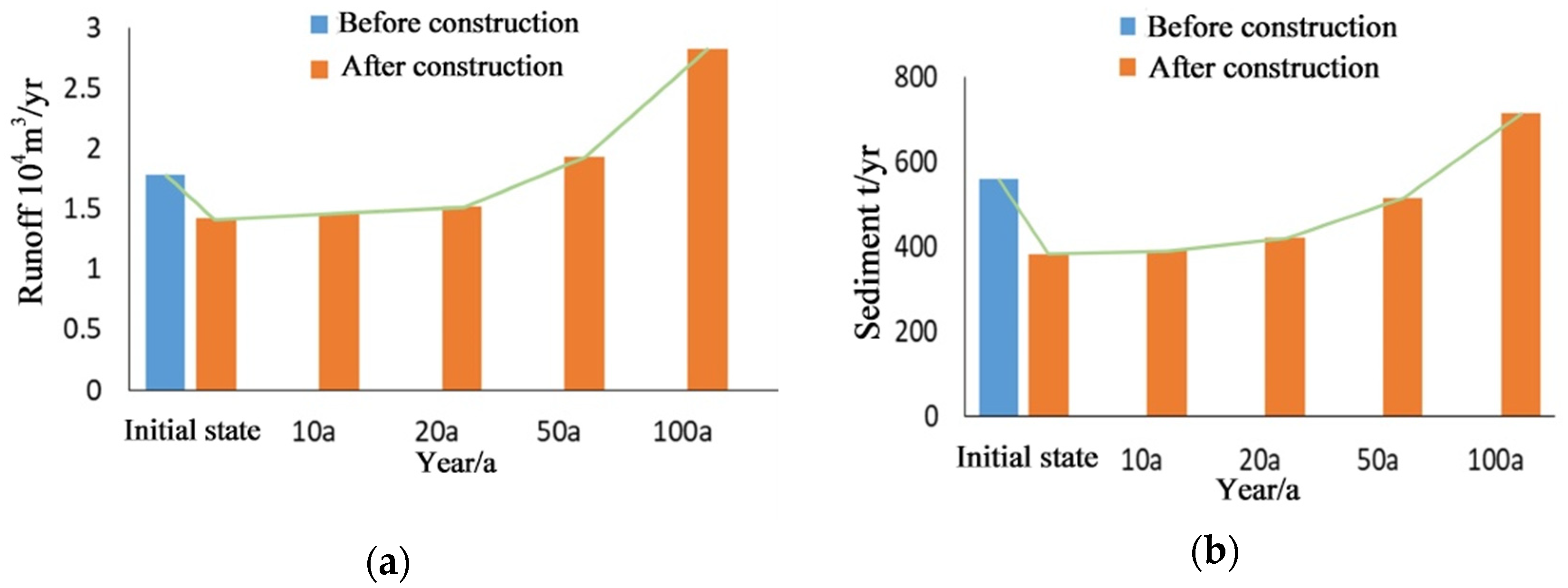
Figure 7 shows the changes in runoff and sediment before and after the construction of the GCHP project (sediment retention dam) and a comparison of numerical simulation results for runoff and sediment over a medium- to long-term scale. It can be observed that, shortly after implementing the GCHP project, runoff and sediment decreased significantly. However, runoff and sediment gradually increase as time progresses, indicating that the project loses its expected effectiveness. The main reason is that the problem of controlling water has not been solved at its source, and addressing water issues is crucial for achieving long-term success.
GCHP is essential, but the secondary disaster effects caused by imperfect projects should not be ignored. Therefore, conducting an in-depth analysis of the core issues of GCHP and exploring sustainable and scientifically systematised management models is necessary.
3.4. Application Example of the Sustainable Natural Gully Stabilisation Project Management Method in Protecting the Loess Plateau
Tiered Water Interception: This method starts by intercepting water at its source. Through hydrological analysis, the natural water flow path and natural catchment area of the basin are identified. Tiered interception channels are progressively built from the natural catchment area, followed by water storage pools (such as stormwater ponds, underground reservoirs, etc.) in key areas of the natural flow path (low-lying areas). This ensures that the water flow is gradually dissipated, realising fragmentation. Ultimately, the goal is to prevent water from flowing into the gully, and the stored water can be reused for urban living and ecological purposes.
Figure 8 illustrates the schematic of the Sustainable Natural Gully and Plateau Protection Engineering Management Method. The implementation measures mainly consist of three aspects.
Huoxiang Gully and Fengjiapan Gully in the Loess Plateau are two typical key project areas for gully stabilisation. The catchment area of Huoxiang Gully is located near the city centre, while the catchment area of Fengjiapan Gully is located in the agricultural region. They represent two types of catchment areas and have adopted two different models: the urban and rural models. This paper uses these two gullies as examples to explain the application method of the natural gully stabilisation project management method in protecting the Loess Plateau.
3.4.1. Delimitation of the Catchment Area of Huoxiang Gully and Fengjiapan Gully in the Loess Plateau
Huoxiang Gully is located in the northeastern part of Xifeng District, with a width of approximately 150 m from north to south and a depth of up to 109 m. It exhibits typical Loess Plateau geomorphological characteristics and has historically been the primary drainage outlet for rainwater and sewage from the old urban area of Xifeng. Fengjiapan Gully is located in the southwestern part of Fengbao Village, Dongzhi Town, Xifeng District, approximately 500 m south of the Fengbao Street area. Before the “gully stabilisation” project was implemented, the runoff in the Fengjiapan Gully catchment area had increased due to the expansion of the Dongzhi Street section. The existing drainage system was insufficient to handle the increased runoff, leading to severe gully head scouring and damage. The gully’s depth increased, and the slope had sparse vegetation and an ecologically fragile environment. In 2015, the Water and Soil Conservation Bureau of Qingyang City implemented a gully stabilisation programme across 37 large plateaus in Qingyang City, covering an area of 3095.87 km2, with 118 gully heads being treated as part of a rescue project. For Fengjiapan Gully, a concrete gully protection of 380 m was installed at the gully head, and a 2.2-hectare abandoned homestead area was reclaimed. A new drainage system was also constructed, the mountain slopes were cut by 105,800 m3, and earthworks of the same volume were filled to restore the terrain. A stone masonry slope protection of 63,500 m3 was established, and 15,000 trees were planted for greening. Willows were planted at the gully bottom to prevent erosion, and 18.5 hectares of trees were planted on the slopes. After the intervention, the gully head area of Fengjiapan Gully was divided into three parts: the gully filling area, the natural plateau area, and the channel area.
Using ArcGIS for hydrological analysis of the gully head DEM, the catchment area of each gully was delineated (see
Figure 9 and
Figure 10). Hydrological analysis shows that the catchment area for Huoxiang Gully is 4868 m
2, while the catchment area for Fengjiapan Gully is 528,604 m
2. The runoff generated within these catchment areas flows into Huoxiang Gully and Fengjiapan Gully, causing plateau surface erosion and gully head erosion. The overlay of remote sensing images and hydrological analysis reveals the extent of the water accumulation areas and the consistency of the flow paths, particularly regarding whether the boundaries of the catchment areas align with the actual topography. Through field investigations and remote sensing image interpretation, the results were found to be nearly identical.
From
Figure 8, it can be observed that the gully head of Huoxiang Gully extends into the city centre. The catchment area within this gully head is nearly entirely urbanised, and road hardening accelerates the runoff concentration process, promoting gully erosion. This places greater demands on the urban drainage system.
Figure 8 shows that the catchment area for Fengjiapan Gully is primarily agricultural land. Compared to road hardening, the underlying surface of agricultural land has a larger infiltration coefficient, and the runoff concentration process in this catchment area is relatively slower. However, over time, the erosion of the gully head and the shrinking of agricultural land will continue, potentially damaging the plateau’s farmland and roads and gradually threatening villages and towns.
3.4.2. Scientific Gully Stabilisation Model for the Loess Plateau Surface Based on Natural Gully Stabilisation Management
Hydrological analysis of the plateau surface shows that the current gully stabilisation measures implemented in the watershed are insufficient. Currently, measures such as filling and drainage are only applied in the gully head areas, which do not effectively block the convergence of runoff from the catchment area, leaving the efforts insufficient. Extensive gully head filling has raised the groundwater table, and the rising groundwater table further affects the stability of these significant gully stabilisation projects. Additionally, improper implementation of specific projects has triggered secondary geological hazards such as landslides, debris flows, collapses, and mudslides.
The natural gully stabilisation management approach respects the natural flow paths of water and begins from the source of runoff—the catchment area. It implements tiered interception by breaking down large-scale interventions into smaller, manageable segments to prevent runoff from flowing into the gully as much as possible.
Urban Model: In the catchment area of the gully head in Huoxiang Gully, a network of interception channels is established along the natural water flow paths and urban road drainage channels. Then, underground reservoirs are constructed in critical areas of the natural water flow path (such as low-lying areas). When runoff occurs, rainwater is stored in these underground reservoirs. This staged storage approach realises a tiered interception and transformation from drainage to storage (
Figure 9). Scientific and rational implementation of this approach can reduce the damage of rainfall floods to the urban surroundings and erosion of the gully head, as well as mitigate the occurrence of secondary geological disasters in the city. The water stored in the underground reservoirs can be purified and used for the city’s daily life and ecological water needs. Additionally, blind drainage pipes are set along the natural flow paths to solve the problem of water not being intercepted by the tiered interception, thus avoiding discharge and erosion along the natural flow paths. Especially in the key areas of natural gully heads (such as gully heads and slope feet), blind drainage pipes are installed, and energy dissipation pools are constructed to reduce hydraulic erosion.
In non-urban areas of the plateau, the green space area is increased to enhance the sponge city function, solving the problem of ecological water conservation. This is achieved by intercepting rainfall and surface water, allowing the water to naturally infiltrate into the deeper soil through plant roots, reducing erosion of the plateau surface and slopes.
Rural Model: In the catchment area of the gully head of Fengjiapan Gully, a network of interception channels is established along the natural water flow paths, agricultural fields, and rural roads. Then, in critical areas of the natural water flow path (low-lying areas), surface water reservoirs (such as flood pools and interception dams) are constructed. When runoff occurs, rainwater is stored in these flood pools. This approach establishes a tiered interception system (
Figure 10). The water stored in the flood pools can also be used for daily irrigation of agricultural fields and ecological water needs.
Additionally, drainage channels are set along the natural flow paths of water, especially in the key areas of natural gully heads (such as gully heads and slope feet). These channels help direct runoff, and energy dissipation pools are created to reduce hydraulic erosion. At the same time, ecological protective slopes are constructed on the surface of the gully stabilisation engineering to address ecological water conservation issues.
5. Conclusions
Ecological protection and high-quality development of the Loess Plateau have become important pathways for the sustainable development of the national ecological and socio-economic systems. The implementation of gully stabilisation engineering, aimed at controlling soil erosion, is of great significance for ensuring food security, improving the ecological environment, developing green industries, and supporting poverty alleviation efforts. The conclusions of this study are as follows:
- (1)
The study confirms that gully stabilisation engineering effectively reduces soil erosion and disaster risks. Measures such as cisterns, flood ponds, upland edge reinforcement, sedimentation dams, and anti-scouring forests significantly lower the risk of floods, landslides, and collapses. Evidence from Qingyang City shows the approach is well-suited to the Loess Plateau, offering both ecological benefits and socio-economic gains like improved agriculture and land stability.
- (2)
There are four types of gully stabilisation engineering models, progressively integrating drainage, filling, slope protection, and ecological measures. Among them, the most comprehensive model—combining all four—offers the highest effectiveness by ensuring both immediate erosion control and long-term ecological restoration.
- (3)
The Sustainable Natural Gully Stabilisation Engineering Management Method addresses post-implementation erosion by managing upland water flow through five key principles: stepwise interception, guided drainage, ecological water conservation, alignment with natural processes, and phased interventions. Grounded in Earth system science, this method integrates hydrology, geology, and ecological resilience to enhance the long-term effectiveness and sustainability of gully stabilisation efforts.
Future research should use remote sensing and AI-driven simulations to assess gully stabilisation effectiveness and analyse the impact of changing precipitation patterns and extreme weather events. This study offers a replicable framework for gully stabilisation, contributing to global land degradation mitigation and sustainable watershed management. The proposed method supports international initiatives like the UN SDGs (Goals 13 and 15) and China’s Yellow River Basin Ecological Protection Strategy, offering valuable insights for regions facing similar erosion and land degradation challenges worldwide.


 ,
, 


