Article

Spatiotemporal Evolution Characteristics and Causative Analysis of Toponymic Cultural Landscapes in Traditional Villages in Northern Guangdong, China

1
School of Humanities and Law, South China Agricultural University, Guangzhou 510640, China
2
Department of History, Jinan University, Guangzhou 510632, China
*
Authors to whom correspondence should be addressed.
Sustainability 2025, 17(1), 271; https://doi.org/10.3390/su17010271
Submission received: 23 November 2024 / Revised: 25 December 2024 / Accepted: 29 December 2024 / Published: 2 January 2025
(This article belongs to the Special Issue Cultural Heritage Conservation and Sustainable Development)

Abstract

:
This research focuses on the cultural landscape of traditional village toponyms in the northern Guangdong region, aiming to reveal the spatial distribution, site selection characteristics, temporal evolution patterns, and influencing factors of toponyms. The study employs quantitative statistics and ArcGIS spatial analysis methods, combining place name classification and kernel density analysis to explore the mechanisms through which natural and human factors influence place name distribution. The main findings are as follows: (1) Traditional village toponyms exhibit a characteristic of “large dispersion and small aggregation” with high-density areas mainly concentrated in Meizhou and Qingyuan. (2) Natural toponyms dominate, showing a strong correlation with river valley and plain environments, while village location demonstrates hydrophilicity and terrain suitability. Human toponyms enrich the landscape’s connotation through cultural identity and social memory, reflecting the profound influences of Confucian agricultural education traditions and immigrant cultures. (3) Economic activities and population migrations during historical periods have significantly shaped the cultural landscape of toponyms, not only promoting the evolution of village site selection and distribution patterns but also profoundly affecting naming conventions for toponyms. This research emphasizes the importance of protecting the cultural landscape of toponyms while achieving a symbiotic relationship between cultural value and economic benefits through regional cultural tourism development, laying a theoretical foundation for the long-term preservation and sustainable development of regional cultural heritage.

1. Introduction

Traditional villages carry rich historical information and cultural memories, possessing profound cultural heritage and distinctive humanistic landscapes [1,2,3,4,5]. Since the late 20th century, traditional villages have been impacted by urbanization and industrialization, facing an accelerated crisis of disappearance. Consequently, the issue of protecting traditional villages has garnered increasing attention in recent years [6,7,8]. In 2012, China officially launched the village census, emphasizing the preservation of traditional villages and their cultural connotations. Under the backdrop of globalization, the primitive cultural forms of traditional villages have been challenged, enhancing people’s sense of cultural identity and prompting communities and individuals to place greater importance on the cultural preservation of traditional villages [9]. As an important symbol and carrier of village culture and social structure, traditional village toponyms have gained significant attention in recent years due to their unique cultural value [10]. Traditional villages, with their unique cultural appeal, historical and humanistic value, and pristine natural environment, have become key highlights in cultural tourism [11]. The northern Guangdong region is an important area where Central Plains culture and Hakka culture intersect and integrate. The traditional village toponyms in this region, due to their unique geographical location and rich historical and cultural heritage, highlight distinctive cultural heritage value. Toponyms serve as linguistic symbols of a region and are vital carriers that bear witness to historical development and transformation [12].
As an important branch of geography, toponymic landscape studies have evolved globally from focusing on the linguistic analysis and historical origins of toponyms to examining their sociocultural functions and spatial distribution characteristics [13]. Although there was no explicit concept of toponymy in ancient China, research related to toponyms was abundant. After the term toponymy was introduced to China in the 1930s, scholars began integrating toponymic theories into China’s specific context. However, the research outcomes during this period were relatively fragmented and did not form a cohesive system. After the 1980s, toponymy developed into a specialized discipline, systematically tracing the origins of Chinese toponymy, summarizing the concepts, spelling methods, origins, and evolutionary patterns of toponyms, and refining specific research methodologies [14]. With the deepening of interdisciplinary collaboration, toponymic research has continuously innovated methodologies in recent years, integrating multiple technical approaches to systematically reveal the spatiotemporal distribution characteristics of toponymic cultural landscapes and their underlying cultural logic [15]. Chinese toponymic research has evolved from being unstructured to becoming a formalized discipline, characterized by a shift from single-method approaches to interdisciplinary innovation. As a product of the integration of people, the environment, and culture, cultural landscapes require deeper theoretical exploration in toponymic studies. Previous research on toponyms has shown insufficient theoretical depth, overlooking aspects such as the role of toponyms in spatial cognition, social memory, and the construction of place identity [16]. In recent years, the application of research paradigms such as cultural ecology [17,18,19], sense of place [20,21,22], landscape gene theory [23,24,25], and cultural memory theory [26,27,28] has broadened the perspectives of toponymic studies to a certain extent. Toponymic research, approached from multidimensional perspectives such as cultural ecology, sense of place, landscape gene theory, and cultural memory theory, addresses the lack of theoretical depth in traditional toponymic studies and provides new academic pathways for the field.
Toponymic research combines both macro-level and micro-level perspectives in its approach. Previously, research generally focused on provincial [29,30,31,32,33] or municipal administrative regions [34,35] as the primary study areas. In recent years, however, academia has tended to use specific landform units [36,37,38] or river basins [39,40,41,42] as research objects, emphasizing the expression of cultural phenomena and ethnic characteristics on a micro scale, thereby expanding new perspectives on regional culture and ethnic studies [43,44,45]. The application of GIS technology in toponymic research is increasingly widespread, with methods such as kernel density analysis, nearest neighbor index, and buffer analysis providing a scientific quantitative framework for exploring the spatial differentiation patterns of toponyms [46,47,48]. From the perspective of regional spatial patterns, the spatial distribution of traditional villages in Guangdong exhibits characteristics of imbalance and clustered distribution [49]. The northeast–central–northwest Guangdong region serves as the core high-density clustering area [50]. From a municipal perspective, toponymic research focuses on the following three high-density distribution areas of traditional villages in Guangdong: Meizhou [51], Qingyuan [52], and Foshan [53]. Existing studies tend to analyze the relationship between toponyms and the distribution characteristics of ethnic groups based on the spatial distribution patterns [54]. The study explains the linguistic cultural landscape of toponyms in Guangdong, focusing on their language types, spatiotemporal patterns, and formation mechanisms [55]. The northern Guangdong region is located within the high-density aggregation area of “northeastern Guangdong-central Guangdong-northwestern Guangdong”, and the spatial distribution pattern of traditional village toponyms is an important entry point for analyzing the regional language and cultural landscape evolution mechanism. However, due to the constraints of underdeveloped economic conditions, research on the historical resources of traditional villages in northern Guangdong is relatively weak, which has diminished attention to the protection of traditional villages. As the core representative of northern Guangdong’s culture, the historical and cultural resources of traditional villages contain profound local knowledge. This study focuses on the cultural landscape of toponyms and innovatively combines spatial analysis with historical evolution, not only deepening the understanding of the traditional cultural connotations of northern Guangdong but also revealing the dynamic evolution patterns of regional human–environment relationships, thus providing theoretical support for the protection of cultural heritage and the sustainable development of the region.
This study is designed to address this research gap lack through the following objectives:
  • The systematic organization and classification of traditional village toponyms in northern Guangdong based on the characteristics of place name cultural landscapes, used to reveal the spatial distribution pattern of place name cultural landscapes in the region.
  • The analysis of the formation mechanisms of place name cultural landscapes in northern Guangdong, used to explain how natural and human geographical features influence the composition of traditional village toponyms.
  • The interpretation of the overall spatial characteristics of traditional villages and their comprehensive influencing factors from the perspective of cultural ecology, used to propose rational protection and development strategies aimed at preserving the value of place name cultural heritage to the greatest extent possible.

2. Materials and Methods

2.1. Data Sources

The northern Guangdong region includes the following six prefecture-level cities: Shaoguan, Heyuan, Meizhou, Qingyuan, Yunfu, and Zhaoqing. Geographically, it borders the following four provinces: Fujian, Jiangxi, Hunan, and Guangxi. This region accounts for 51.94% of Guangdong Province’s total area and 14.83% of its total population. The natural environment of Guangdong is characterized by its diverse and complex topography, extensive river systems, and abundant biological resources, encompassing mountains, hills, and plains. The region is crisscrossed by rivers and streams, primarily belonging to the Meijiang, Xijiang, and Beijiang river systems. Historically, northern Guangdong has served as a crucial cultural bridge between the Lingnan region and the Central Plains, acting as an essential channel for cultural and economic exchanges between the two areas. For instance, from the Song-Yuan to Ming-Qing periods, it was a significant hub for Lingnan migration. The cultures, customs, and technologies brought by migrants took root and developed in northern Guangdong, forming a distinctive regional culture (Figure 1).

2.2. Data Source

The traditional village toponyms in this study were sourced from the Chinese Traditional Village Website (http://www.chuantongcunluo.com/, accessed on 2 September 2024). A total of 160 national-level traditional village toponyms within the study area were selected from the six batches of directories published on the site. The census data on traditional village toponyms were sourced from relevant toponymic gazetteers, including the Qingyuan Toponymic Gazetteer [56] and the Meizhou Toponymic Gazetteer [57], as well as from Guangdong Province’s village census document, “Overview of All Villages in Guangdong [58]”. The geographical coordinates of traditional villages were obtained from Baidu Maps’ latitude and longitude coordinates, while the 30 m digital elevation data were sourced from the Geospatial Data Cloud (https://www.gscloud.cn/, accessed on 5 September 2024). Water system data were extracted from the DEM (Digital Elevation Model) data.

2.3. Methods

2.3.1. Kernel Density Estimation

The Kernel Density Estimation method assumes that geographic events can occur at any location in space, with varying probabilities of occurrence at different locations [59]. This method is used in this study to analyze the spatial concentration and dispersion of the toponymic landscape of traditional villages.
f x = i = 1 n   k x x i h
In the formula, f(x) represents the kernel density value within the threshold range; n indicates the total number of toponyms within the threshold range; h denotes the specified search distance of the density value window; and k is the kernel density value. A higher f(x) value indicates a denser distribution of traditional village toponyms, reflecting a higher degree of clustering.

2.3.2. Average Nearest Neighbor Index

The nearest neighbor index is a commonly used metric for measuring the proximity of point features to one another, reflecting their spatial characteristics and distribution patterns [60]. In this study, it is used to analyze the spatial proximity of the toponymic landscape of traditional villages in the mountainous areas of Guangdong. The calculation formula is as follows:
R = r ¯ 1 r ¯ E = 2 D
In the formula, R represents the Average Nearest Neighbor Index (ANNI), calculated as the mean distance (r1) between nearest neighbors. (rE) denotes the theoretical nearest neighbor distance, and D is the point density. When R < 1, it indicates a clustered distribution; when R > 1, it signifies a uniform distribution; and when R = 1, it represents a random distribution.

2.3.3. Multiple Ring Buffer Analysis

Buffer analysis is a distance-based spatial analysis method that utilizes the topological relationships of spatial objects (points, lines, and polygons). It involves automatically creating buffer polygon layers within a specified width around the target objects, followed by overlaying these layers with the target layers to obtain the results. This process is referred to as the buffer analysis method [61].
This study overlays the buffer analysis results of the distribution map of traditional village toponyms in the mountainous areas of Guangdong with the water system and elevation data within the study area to analyze the extent to which the toponymic landscape of traditional villages is influenced by river systems and elevation.

2.3.4. Standard Deviation Ellipse Analysis Method

The standard deviation ellipse is used to reflect the spatial characteristics of geographic features, including central tendency, dispersion, and directional trend. The first step is to determine the center of the ellipse, which is calculated using the arithmetic mean center through the directional distribution tool [62].
M e a n   c e n t e r   o f   g r a v i t y   x ω ¯ = i = 1 n   ω i x i i = 1 n   ω i y ω ¯ = i = 1 n   ω i y i i = 1 n   ω i
X   a x i s   s t a n d a r d   d e v i a t i o n   σ x = i = 1 n   ( ω i x ¯ i c o s   θ ω i y ¯ i s i n   θ ) 2 i = 1 n   ω i 2
Y   a x i s   s t a n d a r d   d e v i a t i o n   σ y = i = 1 n   ω i x ¯ i s i n   θ ω i y ¯ i c o s   θ 2 i = 1 n   ω i 2
A z i m u t h   t a n   θ = i = 1 n   ω i 2 x i 2 ¯ i = 1 n   ω i 2 y i 2 ¯ i = 1 n   ω i 2 x i 2 ¯ i = 1 n   ω i 2 y i 2 ¯ 2 + 4 i = 1 n   ω i 2 x i 2 ¯ y i 2 ¯ 2 i = 1 n   ω i 2 x i ¯ y i ¯
This study employs the standard deviation ellipse analysis method to examine the evolutionary characteristics of the spatial distribution centers of traditional villages across different historical periods.

3. Results

3.1. Statistics of Traditional Village Toponyms and Landscape Types

This study, referencing existing research findings [63,64,65,66], adopts two classification criteria for the categorization of traditional village toponymic landscapes as follows: semantically, the toponyms must clearly indicate specific categories of geographic entities; and structurally, the toponyms must either function as standalone words or possess separability and substitutability. Based on these criteria, the study organizes key generic terms associated with actual geographic features and divides toponymic landscapes into two main categories as follows: natural landscapes and cultural landscapes, with a total of nine subcategories. The natural landscape category includes geomorphological features, hydrological features, flora and fauna, and geographic orientation. The cultural landscape category encompasses surnames, agricultural practices, architecture, auspicious meanings, and other categories (Table 1).

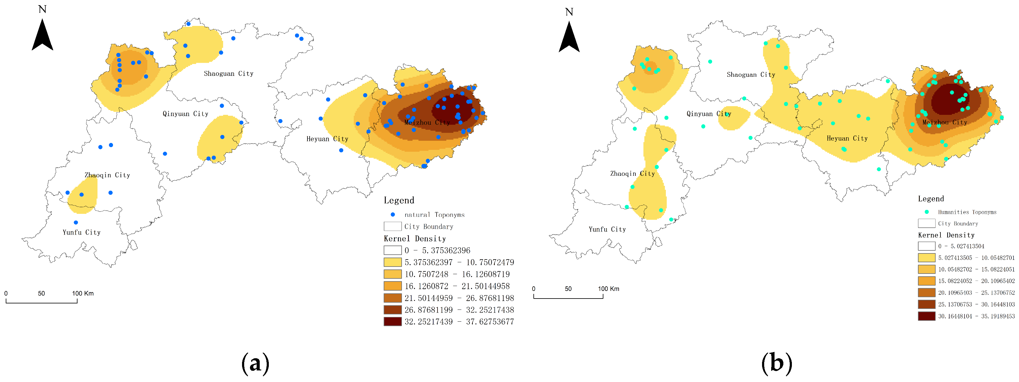
3.1.1. Natural Toponymic Landscape

Natural toponyms reflect the relationship between the local inhabitants and their environment, with their distribution and naming indicating that traditional villages are mainly concentrated in river valleys, plains, and intermontane basins. There are 89 natural toponyms (Table 2), among which geomorphological toponyms are the most numerous, totaling 36. Commonly used characters include “plain”, “flatland”, “pit”, and “ridge”. For example, the name of Shenyuan Village originates from its geographical features—surrounded by mountains on all sides and facing a Fengshui pond. The name “Shenyuan” (literally “deep source”) derives from its secluded mountain location and abundant water sources. There are 29 hydrological toponyms, with commonly used characters such as “stream”, “pond”, “source”, and “water”. For instance, En Village is named after the En Stream, which flows beside it. There are 14 flora and fauna toponyms, with commonly used characters such as “fish” and “orchid”. For example, during the Ming Dynasty, an ancestor of the Lin family, Lin Zhengji, in Lanzhai Village planted orchids in front of and behind their house, as well as on the surrounding mountains and fields, leading to the village’s name, Lanzhai (“Orchid Village”). There are also 10 orientation-based toponyms. For instance, Hounan Village, under Baihou Town, is named due to its location in the southern part of the area.

3.1.2. Cultural Toponymic Landscape

Cultural toponyms reflect the connection between toponyms and local historical narratives, expressing the residents’ sense of place and their perception of the landscape. Statistical analysis (Table 2) indicates that there are 79 cultural toponyms in total. Among these, nine are related to surnames, such as Diaotian Village, which was named after the original residents with the surnames Diao and Tian. Seven are associated with agricultural practices, such as Xiatian Village, known in the Hakka dialect as “Xiàtián”, meaning “fertile fields for rice cultivation”, from which its name was derived. Eighteen are linked to architecture, such as Shilou Village, named after two naturally formed stone chambers located in the area. Twenty-two toponyms convey auspicious meanings, such as Beilian Xinglong Village, originally named Xinglong Village, which was later renamed by its residents—most of whom were engaged in commerce—to Xinglong (“prosperity”) to express their hopes for thriving business. Additionally, there are eight toponyms that could not be classified into any of the above categories.
As shown in Table 2, the distribution characteristics of toponyms in traditional villages of northern Guangdong indicate that natural toponyms dominate, exhibiting significant spatial advantages. Meizhou ranks first with 43 natural toponyms, particularly excelling in topography and geomorphology (17) and in its hydrological system (13), reflecting its complex terrain and well-developed water systems. Simultaneously, Meizhou also stands out in the study of cultural toponyms, with legends and stories (12) and auspicious meanings (6) demonstrating the richness of its cultural connotations. Heyuan, Shaoguan, and Qingyuan show a spatial pattern where natural and cultural toponyms coexist, with Qingyuan’s legends and stories (5) reflecting a distinctive cultural heritage, revealing its profound historical and cultural foundation. Although Zhaoqing and Yunfu have fewer toponyms, their distribution characteristics still highlight the uniqueness of their regional geography and culture. Overall, natural toponyms dominate the distribution pattern of traditional village toponyms in northern Guangdong, while cultural toponyms further reveal the diversity and complexity of the regional cultural landscape.

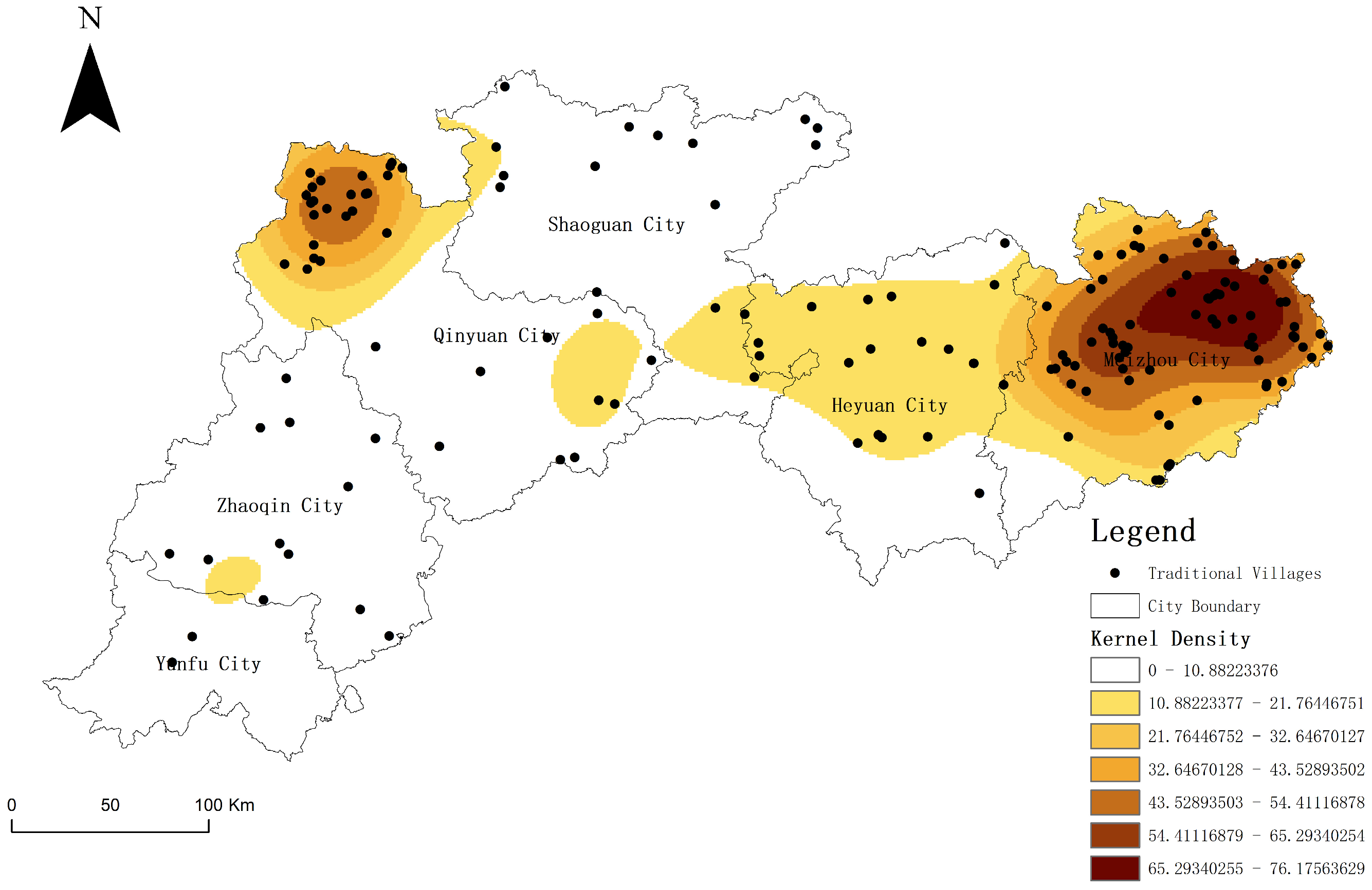
3.2. Spatial Distribution Characteristics of Toponymic Landscapes in Traditional Villages

Using nearest neighbor analysis, the spatial distribution characteristics of 158 traditional village toponyms in the study area were examined. The results indicate an average observed distance of 9577.61 m, an expected average distance of 15,002.15 m, a nearest neighbor ratio of 0.6384, a Z-value of −8.7498, and a p-value of 0.00. These findings demonstrate that the spatial distribution of traditional village toponyms exhibits a significant clustering pattern, deviating from the random distribution hypothesis. The negative Z-value and significant p-value further confirm this spatial clustering, suggesting that the distribution of traditional villages is not random but rather influenced by a combination of geographical conditions, historical transportation networks, and sociocultural factors.
Kernel density analysis (see Figure 2) reveals a distinct zonal clustering pattern in the spatial distribution of traditional villages in northern Guangdong, which can be summarized as “widely scattered, locally clustered”. Meizhou and Qingyuan emerge as high-density regions, with kernel density values exceeding 37.93 villages/km2, indicating a higher concentration of traditional villages in these areas and better preservation conditions.
The high-density zones show a trend of gradual diffusion from the central areas toward the periphery, with a noticeable decline in density gradients, reflecting a layered distribution characteristic of traditional villages within the region. In contrast, traditional villages in other areas are more sparsely distributed, with kernel density values being significantly lower than those in central regions, demonstrating greater spatial dispersion.
This zonal clustering spatial pattern highlights the regional disparities in the preservation status of traditional villages in northern Guangdong. It provides scientific insights for identifying key areas for cultural heritage conservation and optimizing the allocation of traditional village resources.
The analysis results indicate that the landscape of natural toponyms in the study area exhibits a clustered distribution pattern, with a nearest neighbor index (R = 0.68 < 1), and kernel density analysis (Figure 3) showing that the high-density zones of natural toponyms are concentrated in northern Meizhou and northwestern Qingyuan, with density values ranging from 30.80 to 36.96, demonstrating significant spatial clustering. Similarly, the distribution pattern of cultural toponyms reveals comparable characteristics, with a nearest neighbor index (R = 0.79 < 1) and maximum kernel density values of 29.33–35.19 (Figure 3). The dense zones of cultural toponyms are also located in northern Meizhou and northwestern Qingyuan, indicating a high degree of spatial consistency between the distributions of natural and cultural toponyms. Furthermore, the overall spatial distribution of cultural landscape toponyms in the study area exhibits a marked imbalance, characterized by localized clustering and a more dispersed distribution in other regions. This imbalance is primarily determined by terrain conditions, as the complex topography significantly influences the formation and distribution of toponyms.

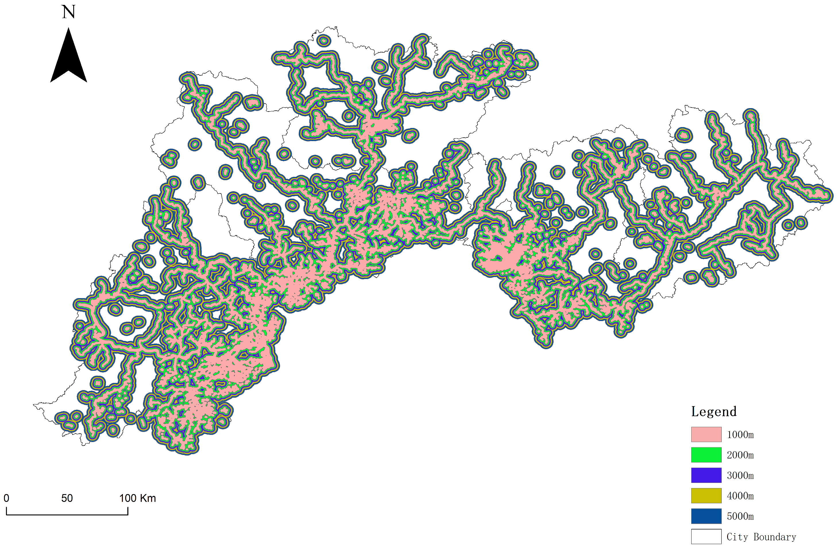
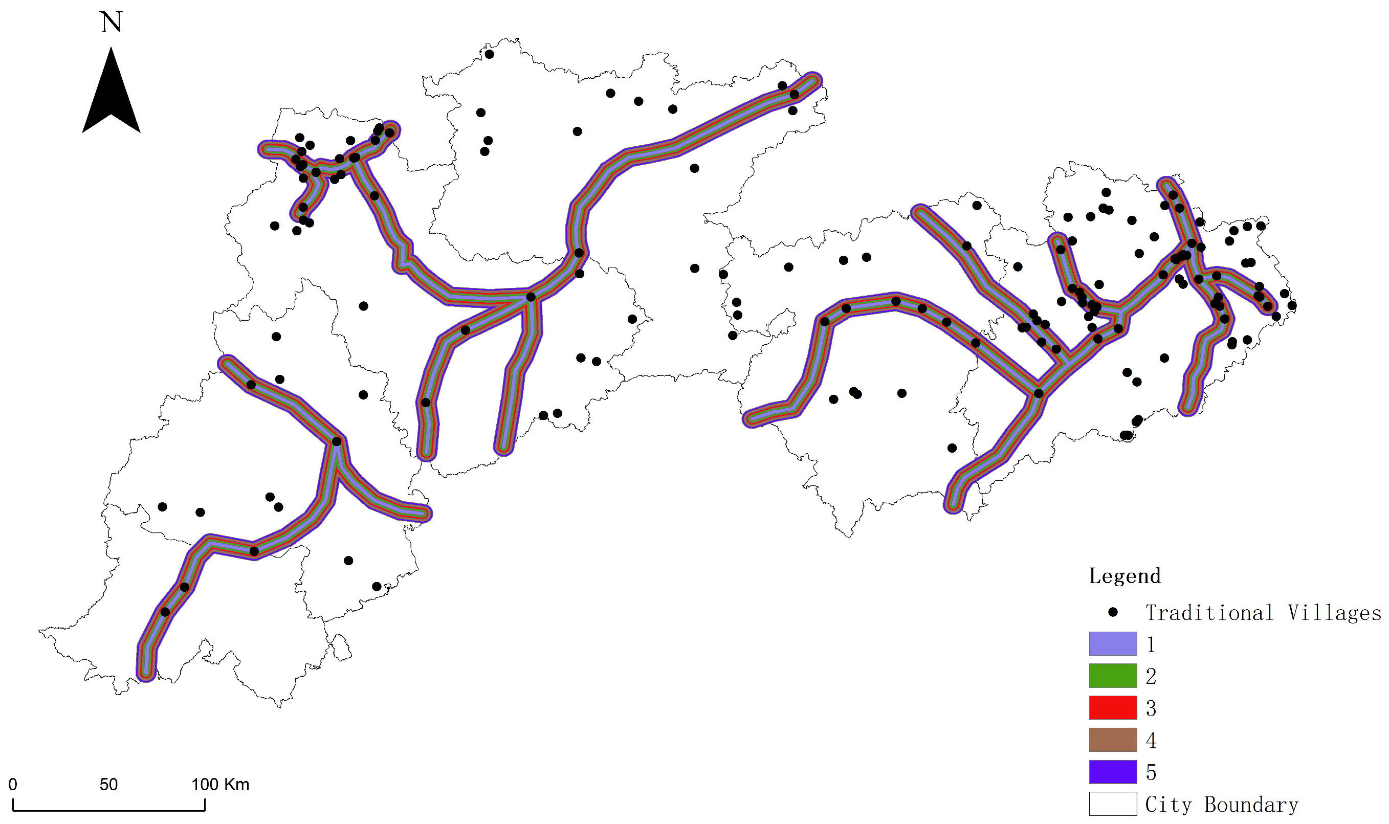
3.3. Analysis of Site Selection Characteristics of Traditional Villages

Referring to Cheng Weiming et al.’s Quantitative Classification Standards for Basic Geomorphic Forms [67], the elevation of traditional villages is classified into five levels based on DEM data as follows: plains and terraces below 30 m, hills between 30 and 200 m, low undulating mountains between 200 and 500 m, medium undulating mountains between 500 and 1000 m, and high undulating mountains between 1000 and 2000 m. The calculation results are shown in Table 3. The geomorphic type statistics for traditional villages in northern Guangdong reveal that their distribution characteristics are significantly constrained by terrain conditions. The results indicate that hilly landforms account for 60.625% of the total, making them the predominant type of village distribution. This reflects the comprehensive advantages of this terrain type in terms of agricultural resource availability, transportation convenience, and defensiveness. Low undulating mountains account for 31.25%, highlighting the settlement development potential in mountainous areas, especially in resource-rich environments. Plains account for only 3.125%, possibly due to the limited extent of plains in northern Guangdong or their high degree of development. Medium and high undulating mountains account for 4.375% and 0.625%, respectively, indicating that steep mountain environments limit the widespread distribution of villages.
In summary, the geomorphic distribution of traditional villages in northern Guangdong demonstrates clear evidence of adaptive selection. Hilly terrain and low undulating mountains offer the most favorable conditions, while extreme terrain significantly restricts the formation and development of villages.
Using the multi-ring buffer tool in ArcGIS spatial analysis, buffer zones were constructed at intervals of 500 m, forming five buffer rings as follows: within 500 m, 501–1000 m, 1001–1500 m, 1501–2000 m, and 2001–2500 m. The distribution of traditional villages in each zone is as follows: 32 within 500 m, 20 in the 501–1000 m range, 12 in the 1001–1500 m range, 8 in the 1501–2000 m range, and 7 in the 2001–2500 m range. The majority of traditional villages are located within 1500 m of water systems, with the number of villages decreasing as the distance from water systems increases, indicating a hydrophilic orientation in site selection. Traditional village locations are strongly associated with water systems and their surrounding environments, predominantly clustering in the primary river basins of the Beijiang River and Meijiang River. In Qingyuan City, the Lianjiang River system, a tributary of the Beijiang River, exhibits a kernel density of traditional village toponyms between 32.47 and 43.29/km2. In Meizhou City, the Tingjiang River system, a tributary of the Hanjiang River, shows a kernel density ranging from 54.12 to 64.94/km2, while the Meijiang River basin displays a kernel density of 21.64–64.94/km2. In Heyuan City, the Dongjiang River basin has a kernel density of 10.82–21.64/km2 (Figure 4).
The slope analysis results for traditional villages in northern Guangdong indicate that most villages are distributed in areas with gentle slopes. Specifically, 131 villages are located in areas with slopes less than 5 degrees, accounting for a high proportion of 81.8%. Next, 18 villages are distributed within the slope range of 5–10 degrees, making up 11.2% of the total. In contrast, the number of villages decreases significantly in areas with steeper slopes as follows: seven villages (4.4%) are found in the 10–15 degree range, two villages (1.3%) in the 15–20 degree range, and two villages (1.3%) in areas with slopes greater than 20 degrees. The distribution of traditional villages shows a clear declining trend as slope increases, highlighting the significant role of terrain slope in constraining historical village site selection(Table 4).
The spatial relationship analysis between traditional villages and the buffer zones of ancient post roads in northern Guangdong reveals that out of a total of 160 traditional villages, 108 (67.5%) are located within the 5000 m buffer zone of ancient post roads. This indicates that ancient post roads significantly influenced the formation and distribution of villages. Specifically, the largest number of villages, 61, are located within the 1000 m buffer zone, accounting for 56.5% of the villages within the buffer zone and 38.1% of the total number of villages(Table 5, Figure 5). This demonstrates that the convenient transportation near ancient post roads played a key role in the formation and clustering of villages. Within the 2000 m buffer zone, there are 24 villages, representing 22.2% of the buffer zone’s total villages, reflecting a gradual weakening of the influence of ancient post roads as the distance increases. The number of villages in the 3000 m, 4000 m, and 5000 m buffer zones is 8 (7.4%), 6 (5.6%), and 9 (8.3%), respectively, showing a decreasing proportion within the buffer zone as the distance increases. This distribution pattern indicates that ancient post roads had a significant guiding effect on the site selection and spatial layout of traditional villages. Villages near ancient post roads benefited from convenient transportation and active economic exchanges, providing advantages for their formation and development, as well as the stability and continuity of settlement structures. Conversely, the number of villages decreases significantly as the distance increases, revealing a high dependency of traditional villages on regional transportation resources (Table 6).
The spatial distribution of traditional villages in northern Guangdong reflects the scientific adaptation and strategic coordination of human activities to environmental and resource endowments. Villages are predominantly located in areas that combine arable land, manageable slopes, and adequate sunlight exposure, while avoiding challenging terrains. Their close association with water systems and ancient trade routes underscores the reliance of these villages on hydrological resources and transportation networks for sustainable development. This integration of natural and historical factors highlights the profound understanding of resource utilization and environmental harmony in traditional societies.

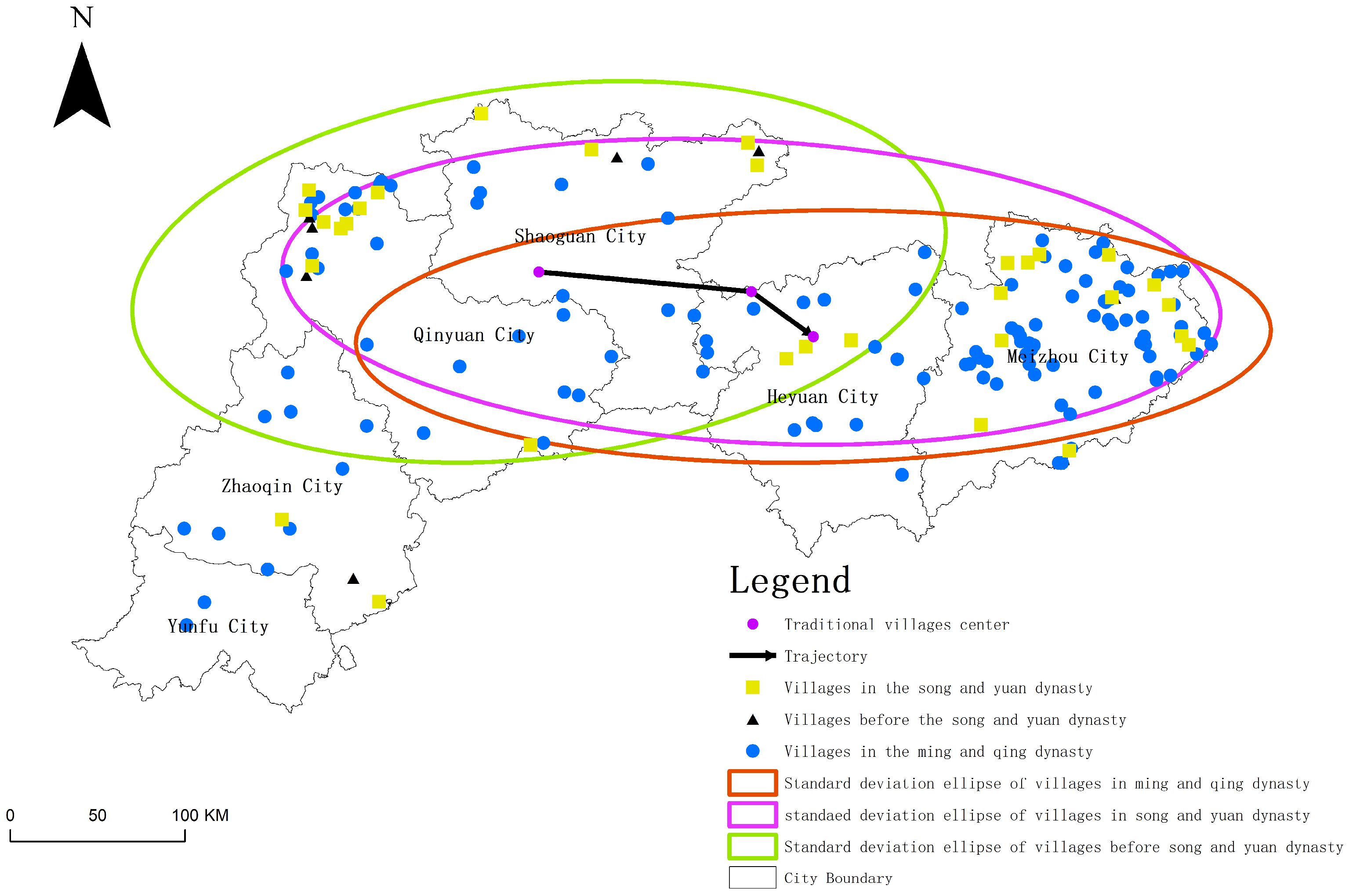
3.4. Spatiotemporal Evolution Characteristics of Toponyms in Traditional Villages

The historical evolution of traditional villages in northern Guangdong reflects a process from sporadic distribution to large-scale development. According to statistical data, only seven villages were established before the Song Dynasty, with a sparse distribution. During this period, village development was constrained by low population density and limited socioeconomic conditions. During the Song and Yuan Dynasties, the number of villages increased to 32, with Qingyuan and Meizhou accounting for a significant proportion. This stage saw a gradual formation of more settlements in northern Guangdong, driven by social stability and agricultural development.
The number of villages grew significantly during the Ming and Qing Dynasties, reaching 121, accounting for more than 75% of the total. This indicates that the Ming and Qing periods marked the peak of village development in the region, influenced by factors such as population growth, economic prosperity, and land development. Spatially, Meizhou had the highest number of traditional villages, totaling 78, particularly prominent during the Ming and Qing Dynasties. This is closely tied to its status as a center of Hakka culture. Additionally, Zhaoqing, Qingyuan, and Heyuan also saw the emergence of many new villages during the Ming and Qing periods, highlighting the role of mountain area development and population growth in promoting the construction of traditional villages. Taking Qingyuan and Meizhou, two traditional village clusters, as examples, the average elevation of village establishment in Qingyuan during the Song and Yuan Dynasties was 187.26 m, which increased to 218.72 m during the Ming and Qing Dynasties. In Meizhou, the average elevation of villages established during the Song and Yuan Dynasties was 169.07 m, rising to 179.02 m in the Ming and Qing periods. This indicates a historical trend of mountain development activities expanding from lower to higher altitudes. As land resources in river valley areas became increasingly saturated, people began moving to higher-altitude regions for cultivation. Using the Hakka ethnic group in Meizhou as an example, the formation of the Hakka community dates back to the Tang and Song Dynasties. During the Song, Yuan, and early Ming periods, the indigenous population of Meizhou was primarily composed of minorities such as the She, Yao, and Xu. A relatively stable Hakka population began to take shape during this period. The Ming and Qing Dynasties marked the maturity of Hakka formation as large-scale migrations caused by warfare significantly altered the local ethnic composition. Through a long process of integration between indigenous and migrant populations, a predominantly Hakka ethnic structure was ultimately established.
The spatial distribution of traditional villages in northern Guangdong during historical periods exhibited significant dynamic changes. Prior to the Song and Yuan Dynasties, village distribution was predominantly stretched in a north–south direction, reflecting the strong reliance of villages on mountainous river valleys and the constraints imposed by natural topography. During the Song and Yuan Dynasties, the range of village distribution expanded, showing a trend of east–west extension. This expansion was closely related to improvements in transportation infrastructure and increased economic activity during this period.
By the Ming and Qing Dynasties, village distribution became more concentrated along an east–west axis, reflecting the deeper integration of economic development and land exploitation, which increasingly aligned villages with transportation and economic core areas. Overall, the spatial distribution of villages underwent a process of concentration, diffusion, and re-concentration, highlighting the profound influence of socioeconomic and natural factors on the evolution of traditional villages (Figure 6).

4. Analysis of the Formation Origins of Traditional Village Toponyms

The naming of toponyms reflects the characteristics of regional topography, hydrology, land use, and local cultural traits. Scholars typically analyze the influencing factors of toponym formation from the following three aspects. First, a rational and applicable classification of toponyms serves as a crucial foundation for studying the cultural landscape of traditional village toponyms. Second, natural factors are a significant source of traditional village toponyms, with topography and water systems being the primary influencing elements. Lastly, the historical and cultural context acts as a vital external driving force in the formation of toponym landscapes [68]. Secondly, natural factors represent a foundational influence on traditional village toponyms, with the geomorphological and topographical features of the landscape playing a pivotal role in determining naming conventions [69]. Equally significant are water systems, whose spatial distribution and ecological functions often inform toponymic patterns. Lastly, the historical and cultural background serves as an indispensable external factor, driving the creation of toponymic landscapes and encapsulating the dynamic interrelations between cultural evolution and physical geography [70]. The influencing factors of the toponymic landscape in traditional villages are complex and intertwined, with natural factors playing a foundational role. Human activities, such as agricultural development and population migration, have increasingly impacted the toponymic landscape. The cultural landscape of toponyms is a product of environmental adaptation, reflecting rural society’s contemplation of the relationship between humans and nature.

4.1. Natural Geographical Factors

The distribution characteristics of traditional villages in northern Guangdong are profoundly influenced by natural geographical conditions, particularly in terms of topography, water systems, and slope orientation. Villages are predominantly distributed in hilly areas and gently undulating mountainous regions, accounting for over 90% of the total. These terrain types not only provide arable land resources but also offer defensive advantages, making them ideal locations for ancient villages. In contrast, plains, due to their high degree of development or limited area, account for only 3% of village distribution, while medium and highly rugged mountainous areas restrict the number of villages due to their harsh environments. Water systems have a particularly significant impact on village distribution. Kernel density analysis indicates that most villages are concentrated within 1500 m of major rivers such as the Meijiang and Beijiang Rivers [71], with dense clusters closely overlapping river basins. This affinity for water highlights the foundational role of water resources in agricultural production and daily life while also reflecting the transportation advantages of river valley terrains. Slope and slope orientation analysis further reveal the micro-level effects of the natural environment. Areas with slopes less than 5° account for over 80% of village clusters. East-, southeast-, and south-facing slopes, due to their favorable light and thermal conditions, are the primary orientations for village distribution. In contrast, north- and northwest-facing slopes, with less favorable climatic conditions, host significantly fewer villages.
Overall, natural geographical conditions not only form the environmental backdrop for the formation of traditional villages but also shape their distribution characteristics. Adaptive site selection reflects the profound understanding of the natural environment by traditional societies, highlighting the wisdom of settlement construction tailored to local conditions and in harmony with nature.
Naming marks the beginning of domesticating the environment, with toponyms serving as intermediaries between the realities of the geographical environment and human perceptions of it. In early periods, when the natural environment imposed significant constraints on ancient human production and livelihood, naming based on geographical elements reflected their reverence for nature. Relatively isolated geographical conditions help mitigate the impact of wars and disasters, allowing traditional villages to preserve their unique and intact landscapes. The mountain–water pattern establishes the macro distribution framework of traditional villages. Village site selection is influenced by natural factors such as elevation and water systems. For instance, in the Hakka settlements of Meizhou, a spatial distribution pattern of “where there are mountains, there are Hakka; where there are Hakka, they dwell in the mountains” has emerged.

4.2. Economic Activity Factors

The spatial pattern of the toponymic cultural landscape in traditional villages of northern Guangdong is closely linked to the economic activities associated with mountain area development during historical periods. During the Song and Yuan Dynasties, with the large-scale migration of people from the Central Plains, agricultural development gradually expanded in northern Guangdong. River valley plains and gentle slopes became core areas for village site selection due to their fertile land and abundant water resources. Terms such as “field”, “ditch”, and “pond” frequently appear in toponyms, reflecting the profound influence of paddy-based agricultural economies on village formation and toponymic naming practices.
During the Ming and Qing Dynasties, the improvement of transportation networks reshaped the distribution patterns of villages. Ancient post roads, serving as the main arteries of economic connection between northern Guangdong and the Central Plains during historical periods, attracted a significant number of villages along their routes. These roadside villages not only became transportation nodes but also gradually developed into hubs for regional economic exchange [72]. Toponyms containing terms related to transportation, such as “street” and “bridge”, reflect the impact of economic activities on the distribution of villages during this period.
The deepening development of mountainous areas also drove the prosperity of trade and commerce, leading to the gradual formation of commercial hubs represented by Meizhou and Qingyuan. The frequent appearance of commercial terms such as “market” and “shop” in toponyms reflects the attractiveness of the regional market system to villages during the Ming and Qing Dynasties. Villages built along rivers, particularly concentrated in the Meijiang and Beijiang river basins, became key regions where agriculture and commerce were integrated. The cultural landscape of toponyms in these areas demonstrates the diversity of their economic functions.
In summary, the formation of the cultural landscape of traditional village toponyms in northern Guangdong is the result of the combined effects of agricultural development, transportation accessibility, and commercial activities. The development of mountainous areas in historical periods not only influenced the spatial distribution of villages but also recorded the prosperity and evolution of the regional economy through toponyms.

4.3. Factors of Population Migration

The formation of the cultural landscape of traditional village toponyms in northern Guangdong is closely related to the historical process of population migration, particularly prominent during the Tang-Song and Ming-Qing periods. The construction of the Dayuling New Route during the Tang Dynasty facilitated the influx of migrants from the north. However, early development activities were primarily concentrated along the route, with village distribution limited to areas with convenient transportation. From the late Song Dynasty to the early Ming Dynasty, waves of migration triggered by warfare accelerated the formation of traditional villages in northern Guangdong. As key transportation hubs between the Central Plains and Lingnan, Qingyuan, and Meizhou became important transit stations for migrants. During the Ming and Qing Dynasties, numerous villages were established along the Xingzi Ancient Route, Chating Ancient Route, and Yangshan Ancient Route in Lianzhou. The cultural landscape of these village toponyms exhibits a high degree of correlation with transportation routes [73].
The cultural background of migrants profoundly influenced the naming methods of toponyms. Village names derived from surnames not only reflect the Confucian concept of “dwelling in one place for generations” but also reinforced the internal cohesion of family clans through toponyms. The widespread occurrence of such names highlights the deep integration of migrant culture with regional spaces. Additionally, toponyms based on legends and stories record the pioneering journeys of migrants in challenging environments. Although some of these names include fictional elements, the moral values and commemorative functions they embody enrich the cultural connotations of village place name landscapes.
As an essential link to regional economic and cultural exchange, the ancient post roads of southern Guangdong played a significant role in shaping the cultural landscape of traditional village toponyms. These post roads not only facilitated the migration and integration of ethnic groups such as the Zhuang, Yao, and Han but also promoted the spread and development of regional culture. Traditional villages, serving as nodes along these post roads, not only document the historical process of ethnic migration but also bear witness to the interaction and exchange of diverse cultures in northern Guangdong.

4.4. Cultural Factors

The distribution and origins of toponyms reflect the human–environment relationship during specific historical periods. Cultural ecology emphasizes human cultural adaptation under specific environmental conditions. From the perspective of cultural ecology, toponyms reveal how human societies interact with their surrounding natural environment and how these interactions shape cultural formation and environmental evolution. This perspective aids in interpreting the natural environment and regional social development characteristics embedded within toponyms [74,75]. The influence of Confucian culture on the toponymic cultural landscapes of traditional villages in northern Guangdong is mainly reflected in two dimensions: spatial organization and environmental perception.
In terms of spatial distribution, the Confucian concept of “harmony between heaven and humanity” is directly reflected in the site selection and naming of villages. Traditional villages are often located near mountains and rivers, emphasizing Fengshui layouts, which embody Confucian ideals of natural esthetics [76]. As a cultural landscape element, toponyms serve as a way for people to perceive, understand, and shape their local environment to meet daily needs. Through the emotional significance imparted via naming, physical spaces are transformed into places. “Topophilia” refers to a type of emotional attachment associated with specific places. Environmental stimuli affect human senses, and these stimuli, as perceivable intentions, allow human emotions and ideas to find a sense of anchoring [77].
In terms of spatial hierarchy, the village layout, centered around ancestral halls, forms a spatial structure with ethical order, reflecting the pursuit of an ideal living environment. The naming of internal village spaces also displays strong Confucian cultural characteristics. Streets and buildings are commonly named with words such as “Reverence”, “Righteousness”, “Benevolence”, and “Virtue”, creating a cultural spatial sequence with an educational and moralizing significance. For example, the ancestors of Songping Village followed the Central Plains tradition of valuing education, establishing private schools such as “Zhiyuan Hall”, “Xuegu Study”, and “Cunyi Hall”. Furthermore, the clan system, as an essential component of Confucian culture, reflects its social organizational functions through toponyms. Villages and alleys named after surnames highlight the characteristics of clan-based settlements, strengthening group identity. For instance, the “Deng Clan Ancestral Hall” in Dengwu Village is located at the center of the settlement, with residential houses distributed in a circular pattern around the ancestral hall.
In the process of the human–environment interaction, these place names imbued with Confucian culture continuously reinforce the cultural identity of village residents, forming a unique cultural ecology. The formation of this cultural ecology is both a spatial manifestation of Confucian culture and an accumulation of cultural memory within local societies over time. In the contemporary context, these place names, carrying historical memory, are not only an essential part of cultural heritage but also serve as critical windows for studying traditional cultural ecosystems. Heritage provides humanity with a sense of existence by transmitting eternal values and an unbroken lineage that supports identity. The historical legends carried by place names play a key role in the construction and transmission of social memory. The continuity of this memory fosters cultural identity and a sense of belonging within communities, thereby strengthening the uniqueness of local culture and enhancing social cohesion.

5. Conclusions

The spatiotemporal evolution of the cultural landscape of traditional village toponyms in northern Guangdong reflects a systemic process of interaction between the natural geographical environment and sociocultural factors. It demonstrates the adaptation and reconstruction of the human–environment relationship within the regional system during specific historical periods. The conclusions of the research are as follows:
(1)
In the dimension of physical geography, the spatial distribution of villages is significantly constrained by topography and hydrological patterns, with settlements primarily concentrated in hilly and gently undulating mountainous areas. These regions feature gentle terrain, high development potential, favorable farming conditions, and residential safety, making them optimal locations for village sites. Slope analysis indicates that over 80% of villages are located on gentle slopes with gradients of less than 5°, highlighting the traditional settlements’ strong dependence on topographical suitability. At the same time, proximity to water is one of the core driving factors in site selection. Villages are often laid out along river valley plains, where water systems not only serve as support systems for agricultural irrigation and daily living needs but also improve regional accessibility, thereby promoting spatial clustering and the evolutionary diffusion of villages.
(2)
In the dimension of human geography, the cultural landscape construction of village toponyms profoundly reflects the combined influence of Confucian culture and migration culture. The Confucian concepts of “clan ethics” and “harmony between heaven and humanity” are particularly prominent in the naming of toponyms. Through the use of symbols such as surnames, moral vocabulary, and auspicious meanings, toponyms are imbued with cultural identity and an educative function, reinforcing the social structural order of village spaces.
(3)
In the dimension of historical economic activities, the spatial evolution of toponyms reflects the dual driving forces of agricultural development and the expansion of transportation networks. During the Song and Yuan Dynasties, agricultural development in river valleys facilitated the initial clustering of villages. During the Ming and Qing Dynasties, with the improvement of ancient post roads, the spatial layout of villages gradually concentrated along transportation routes. This dynamic evolutionary process demonstrates the role of economic activities in the adaptive adjustment and reconstruction of human settlement spaces, uncovering the underlying mechanisms of the cultural landscape of village toponyms. Additionally, the deep integration of Central Plains migrants and Hakka culture has created diverse cultural symbols, as reflected in the spatial distribution of toponyms associated with legends and symbolic meanings. This cultural narrative, carried by toponyms, materializes historical memory and regional identity within the spatial landscape, constructing cultural imagery and an emotional connection to these villages.
In conclusion, northern Guangdong occupies a pivotal position as a hub for cultural exchange between the Central Plains and Lingnan regions. Over time, it has borne the processes of cultural transmission, collision, and integration, forming a unique cultural-geographical transitional zone. The formation and evolution of the cultural landscape of traditional village toponyms in this region are the result of the combined influences of the natural geographical background, cultural systems, and historical economic dynamics. Through the analysis of spatiotemporal distribution patterns and the cultural implications of toponyms, it is possible to uncover the evolutionary logic and internal mechanisms of the human–environment relationship within the regional system across different historical periods. This not only enriches the theoretical interpretation of toponymic cultural landscapes but also provides scientific foundations and practical guidance for regional cultural heritage preservation and spatial planning.

Author Contributions

Conceptualization, H.Z. and C.L.; methodology, J.L.; software, J.L.; validation, J.Y. and Y.X.; investigation, J.Y. and Y.X.; resources, J.L.; data curation, J.L.; writing—original draft preparation, J.L.; writing—review and editing, H.Z. and C.L.; visualization, C.L.; supervision, C.L. and H.Z.; project administration, H.Z.; funding acquisition, H.Z. and C.L. All authors have read and agreed to the published version of the manuscript.

Funding

This research was supported by the Major Project of the National Social Science Fund of China (Grant No. 19ZDA201) and the Regular Project of the “14th Five-Year Plan” for the Development of Philosophy and Social Sciences in Guangzhou for 2024 (Grant No. 2024GZQN24).

Institutional Review Board Statement

Not applicable.

Informed Consent Statement

Not applicable.

Data Availability Statement

The original contributions presented in this study are included in the article. Further inquiries can be directed to the corresponding authors.

Conflicts of Interest

The authors declare no conflicts of interest.

References

  1. Zhou, Y.; Liu, M.; Xie, G.; Liu, C. Landscape ecology analysis of traditional villages: A case study of Ganjiang River Basin. Appl. Sci. 2024, 14, 929. [Google Scholar] [CrossRef]
  2. Bi, S.; Du, J.; Tian, Z.; Zhang, Y. Investigating the spatial distribution mechanisms of traditional villages from the human geography region: A case study of Jiangnan, China. Ecolog. Inform. 2024, 81, 102649. [Google Scholar] [CrossRef]
  3. Zhang, J.; Zhuang, Z.; Fang, Y. A review and prospect of research on the protection of traditional Chinese villages based on CiteSpace. J. Hengyang Norm. Univ. 2023, 6, 16–24. [Google Scholar]
  4. Hu, K.; Lin, W.; Fan, L.; Yang, S.; Zhang, T. Spatial Differentiation and Influencing Factors of Traditional Villages in Fujian, China: A Watershed Perspective. Sustainability 2024, 11, 4787. [Google Scholar] [CrossRef]
  5. Lu, X.; Tan, D.; Zhou, Y.; Xie, Y.; Chen, Z. Traditional village perception and protection behavior: The mediating role of local identity and the impact of different population differences. J. Asian Archit. Build. Eng. 2024, 1–18. [Google Scholar] [CrossRef]
  6. Cao, C.; Qiu, Y. Selected Laws and Regulations on the Protection of Historical and Cultural Cities, Towns, Villages and Traditional Villages; China Architecture & Building Press: Beijing, China, 2015. [Google Scholar]
  7. Yuan, L. Guidance Manual for the Protection of Traditional Chinese Villages; Xueyuan Publishing House: Beijing, China, 2023. [Google Scholar]
  8. Xu, J.; Liu, S.; Mao, Z.; Hou, Q. Spatial distribution characteristics and protection system scheme of traditional Chinese villages. J. Hunan Univ. (Soc. Sci. Ed.) 2021, 2, 152–160. [Google Scholar]
  9. Zheng, N. Activating Nostalgia: The Inheritance and Reconstruction of Traditional Village Cultural Ecology. Jiangsu Soci. Sci. 2024, 1, 146–155. [Google Scholar]
  10. Ren, Y. The current situation, value significance and path exploration of traditional village protection. Acad. Res. 2023, 12, 47–53. [Google Scholar]
  11. Zhao, X.; Wang, Y. A review of relevant research on the impact of rural tourism on the development of traditional villages in my country in the past 20 years. J. Hebei Univ. Techn. (Soc. Sci. Ed.) 2023, 15, 85–95. [Google Scholar]
  12. Lu, N.; Zeng, P. Spatial distribution pattern and formation mechanism of Tianjin place name cultural landscape. Arid Land Resour. Environ. 2022, 36, 194–201. [Google Scholar]
  13. Liu, Q.; Sun, P. Spatial distribution characteristics and causes of rural place name cultural landscape in the Three Gorges Reservoir area (Chongqing section). J. Mt. Sci. 2024, 1, 108–122. [Google Scholar]
  14. Sun, D. Introduction to the Historiography of Place Names; China Social Sciences Press: Beijing, China, 2008. [Google Scholar]
  15. Ma, R.; Chen, J. Spatial pattern and influencing factors of cultural landscape of common place names in the Yangtze River Delta region. Geogr. Res. 2022, 3, 764–776. [Google Scholar]
  16. Ji, X.; Wang, W. Review and Prospect of Toponymy Research since the Critical Turn. Prog. Geogr. 2016, 7, 910–919. [Google Scholar]
  17. Yang, R.; Gao, M. The evolution of enclosure name landscape since the Qing Dynasty from the perspective of cultural ecology. Arid Land Resour. Environ. 2023, 8, 169–177. [Google Scholar]
  18. Adom, D. The place and voice of local people, culture, and traditions: A catalyst for ecotourism development in rural communities in Ghana. Sci. Afr. 2019, 6, 184. [Google Scholar] [CrossRef]
  19. García-Delgado, F.J.; Martínez-Puche, A.; Lois-González, R.C. Heritage, tourism and local development in peripheral rural spaces: Mértola (Baixo Alentejo, Portugal). Sustainability 2020, 21, 9157. [Google Scholar] [CrossRef]
  20. Zhao, S.; Zheng, H. An exploration of place name culture in Yunnan Province from the perspective of sense of place. J. Southwest For. Univ. (Soc. Sci.) 2023, 4, 102–110. [Google Scholar]
  21. Indraswara, M.S.; Suprapti, A.; Sardjono, A.B.; Hilmy, M.F.; Pribadi, S.B. Maintaining Sense of Place in a Historic Village: Insights from the Pekalongan Arabic Village, Indonesia. J. Int. Soc. Study Vernac. Settl. 2023, 10, 8. [Google Scholar] [CrossRef]
  22. Lekakis, S.; Dragouni, M. Heritage in the making: Rural heritage and its mnemeiosis at Naxos island, Greece. J. Rural Stud. 2020, 77, 84–92. [Google Scholar] [CrossRef]
  23. Wang, T.; Wu, Y. Genetic information chain and bionic model construction of place name cultural landscape: Taking the place names of the South China Sea Islands as an example. World Geogr. Res. 2023, 10, 28–40. [Google Scholar]
  24. Makhzoumi, J.M. Unfolding landscape in a Lebanese village: Rural heritage in a globalising world. Int. J. Herit. Stud. 2009, 15, 317–337. [Google Scholar] [CrossRef]
  25. Zheng, X.; Herman SS, B.; Salih, S.A.; Ismail, S.B. Sustainable Characteristics of Traditional Villages: A Systematic Literature Review Based on the Four-Pillar Theory of Sustainable Development. Sustainability 2024, 16, 10352. [Google Scholar] [CrossRef]
  26. Wei, B.; Mu, J. Cultural memory theory and the reconstruction of traditional village cultural space: A case study of Korean traditional villages in Yanbian. Chin. Cult. Herit. 2023, 5, 51–58. [Google Scholar]
  27. Jiao, Q. Study on the Factors That Influence Memory Perception of Conventional Village Space—Taking Luxiang Ancient Village as an Example. Acad. J. Archit. Geotech. Eng. 2023, 8, 43–48. [Google Scholar]
  28. Castillo, J.A.Q.; Narbarte, J.; Iriarte, E. What is a village? Agricultural landscapes, collective action and medieval villages in northern Iberia. Antiquity 2023, 395, 1279–1295. [Google Scholar] [CrossRef]
  29. Dong, J.; Nasundalai, S. Study on the spatial distribution characteristics of multilingual place names in Xinjiang. World Geogr. Res. 2021, 5, 1106–1114. [Google Scholar]
  30. Bohua, L.; Sha, Y.; Peilin, L.; Yindi, D.O.U. Spatial Distribution of Traditional Villages and Influence Factors in Hunan Province. J. Landsc. Res. 2016, 8, 63. [Google Scholar]
  31. Li, M.; Ouyang, W.; Zhang, D. The spatial distribution characteristics and influencing factors of traditional villages in Guangxi Zhuang Autonomous Region. Sustain. Dev. 2022, 15, 632. [Google Scholar] [CrossRef]
  32. Liu, W.; Xue, Y.; Shang, C. Spatial distribution analysis and driving factors of traditional villages in Henan province: A comprehensive approach via geospatial techniques and statistical models. Herit. Sci. 2023, 11, 185. [Google Scholar] [CrossRef]
  33. Jia, A.; Liang, X. GIS-based analysis of the spatial distribution and influencing factors of traditional villages in Hebei Province, China. Sustainability 2023, 15, 9089. [Google Scholar] [CrossRef]
  34. Sun, M.; Zeng, P.; Zhang, H.; Chang, Y. Spatial distribution characteristics and causes of cultural landscape of village names in Jinan. J. Surv. Map. Sci. Technol. 2020, 3, 319–324. [Google Scholar]
  35. Shang, H.; Chen, P.; Luo, Y. The spatial distribution characteristics and influencing factors of traditional villages in Qiandongnan Prefecture. J. Landsc. Stud. 2021, 13, 3. [Google Scholar]
  36. Hu, X.; Chen, Z. Spatial distribution characteristics of place name cultural landscape in Hehuang Valley, Qinghai. J. Cap. Norm. Univ. (Nat. Sci. Ed.) 2023, 44, 83–91. [Google Scholar]
  37. Jin, L.; Wang, Z.; Chen, X. Spatial distribution characteristics and influencing factors of traditional villages on the Tibetan Plateau in China. Int. J. Environ. Res. Public Health 2022, 19, 13170. [Google Scholar] [CrossRef] [PubMed]
  38. Li, B.; Wang, J.; Jin, Y. The spatial distribution characteristics and influencing factors of traditional villages in the hilly and gully areas of northern Shaanxi Province. Sustain. Dev. 2022, 22, 15327. [Google Scholar]
  39. Zhao, S.; Hu, X. Temporal and spatial characteristics and influencing factors of settlement place name cultural landscape from the perspective of ancient waterways: A case study of the Yuanshui River Basin in Hunan Province. Geogr. Res. 2024, 1, 214–235. [Google Scholar]
  40. Xu, Y.; Yang, X.; Feng, X.; Yan, P.; Shen, Y.; Li, X. The spatial distribution and site selection adaptation mechanism of traditional villages along the Yellow River in Shanxi and Shaanxi provinces. River Res. Appl. 2023, 39, 1270–1282. [Google Scholar] [CrossRef]
  41. Wei, D.; Wang, Z.; Zhang, B. Traditional Village Landscape Integration Based on Social Network Analysis: A Case Study of the Yuan River Basin in South-Western China. Sustainability 2021, 13, 13319. [Google Scholar] [CrossRef]
  42. Bai, G. Driving mechanism and optimization path of traditional village style protection in ethnic minority areas under the perspective of rural revitalization. Natl. Stud. Qinghai 2024, 35, 65–73. [Google Scholar]
  43. Li, W.; Yang, B. Spatial pattern, generation mechanism and protection strategy of Tibetan village place names: A case study of Xiahe County, Gannan Tibetan Autonomous Prefecture. Geogr. Res. 2019, 38, 784–793. [Google Scholar]
  44. Li, Y.; Fan, W.; Yuan, X.; Li, J. Spatial distribution characteristics and influencing factors of traditional villages based on geodetector: Jiarong Tibetan in Western Sichuan, China. Sci. Rep. 2024, 14, 11700. [Google Scholar] [CrossRef] [PubMed]
  45. Shao’an, D.; Zu, J. Using geospatial technology and statistical models to analyze the spatial distribution characteristics and driving factors of ethnic minority villages in China. J. Mt. Sci. 2024, 21, 2770–2789. [Google Scholar]
  46. Miao, Q.; Hu, D. Spatial distribution and influencing factors of traditional villages in central Henan Province. J. Taiyuan Norm Univ. (Nat. Sci. Ed.) 2024, 23, 79–86. [Google Scholar]
  47. Li, Y.; Hong, J.; Niu, F. Traditional Village Spatial Distribution and Its Influencing Factors Based on Density Field Hotspot Detection Model—Taking Southwest China as an Example. J. Nat. Sci. 2024, 46, 178–187. [Google Scholar]
  48. Qi, J.; Zhang, S. Spatial characteristics of the cultural landscape of traditional village names in Hunan. J. Surv. Map. 2023, 48, 220–230. [Google Scholar]
  49. Feng, Y.; Yu, W. Study on spatial distribution characteristics and influencing factors of traditional villages in Guangdong Province. Geogr. Sci. 2017, 37, 236–243. [Google Scholar]
  50. Chen, B.; Xu, S. Analysis of multi-scale characteristics and influencing factors of spatial distribution of traditional villages: A case study of 263 traditional villages in Guangdong Province. Soil Water Conserv. Res. 2023, 30, 423–429. [Google Scholar]
  51. Sun, Y.; Wang, Y. Study on the spatial distribution evolution of traditional Hakka villages in Meizhou based on GIS. Econ. Geogr. 2016, 36, 193–200. [Google Scholar]
  52. Ren, H.; Cao, X. Research on the characteristics and evolution of the historical spatial and temporal pattern of rural settlements from the perspective of inheritance: A case study of Lianzhou City, Guangdong Province. Human Geogr. 2012, 27, 87–91. [Google Scholar]
  53. Liu, S.; Li, F. “Regional” interpretation of the eight scenic spots of Foshan ancient villages from the perspective of cultural ecology. Chin. Gard. 2020, 36, 91–95. [Google Scholar]
  54. Yuan, S.; Tang, G. Spatial distribution pattern of traditional villages in Guangdong and its ethnic characteristics. Trop. Geogr. 2017, 37, 318–327. [Google Scholar]
  55. Wang, B.; Huang, X. Analysis of the spatial structure and landscape characteristics of the language and culture of place names in Guangdong. Human Geogr. 2012, 27, 39–44. [Google Scholar]
  56. Qingyuan City Place Names Committee. Qingyuan City Place Names; Guangdong Provincial Map Publishing House: Guangzhou, China, 1993. [Google Scholar]
  57. Meizhou City Place Names Committee. Place Names of Meizhou City, Guangdong Province; Guangdong Provincial Map Publishing House: Guangzhou, China, 1989. [Google Scholar]
  58. Guangdong Provincial People’s Government Local Chronicles Office. Village Conditions of Guangdong; South China University of Technology Press: Guangzhou, China, 2021. [Google Scholar]
  59. Huang, H.; Miao, H. Spatial pattern and causes of traditional villages in Northwest China. Econ. Geogr. 2021, 41, 233–240. [Google Scholar]
  60. Ge, C.; Wang, Y.; Zhou, D. Study on spatial distribution characteristics and influencing factors of traditional villages in Yunnan Province. J. Guizhou Univ. (Nat. Sci. Ed.) 2022, 39, 97–104. [Google Scholar]
  61. Yang, C.; Wan, C. Study on the spatiotemporal evolution characteristics of traditional villages in Dabie Mountains, western Anhui Province. Reg. Res. Dev. 2023, 42, 174–180. [Google Scholar]
  62. Shao, X.; Zhao, J. Study on the spatiotemporal differentiation characteristics and driving mechanisms of traditional villages in Shanxi Province. J. Taiyuan Norm. Univ. (Nat. Sci. Ed.) 2023, 22, 87–96. [Google Scholar]
  63. Zhou, Y.; Yu, L.; Yue, Y. Analysis of the cultural landscape of rural place names in Taihang Mountains based on GIS: A case study of Licheng County, Shanxi Province. Arid Land Res. Environ. 2022, 36, 68–76. [Google Scholar]
  64. Zhao, Z.; Dong, S.; Yang, W. Analysis of the cultural landscape of place names in Changchun based on GIS. J. Chang. Norm. Univ. 2023, 42, 119–127. [Google Scholar]
  65. Lin, L.; Wang, J.; Zeng, J.; Li, Y.; Liu, Y. Analysis on the characteristics and influencing factors of place name cultural landscape in Hong’an County, Hubei Province. Mod. Urban Res. 2024, 3, 14–21. [Google Scholar]
  66. Liao, H.; Luo, T.; Zhang, Y.; He, Q. Spatial distribution characteristics of cultural landscape of village names in Fujian Province. J. Urban Stud. 2024, 3, 80–88. [Google Scholar]
  67. Cheng, W.; Zhou, C. Quantitative extraction and analysis of basic morphological types of China’s landforms. J. Geo-Inf. Sci. 2009, 6, 725–736. [Google Scholar]
  68. Xue, Y. The impact of place name classification methods on the spatial differences of village place name cultural landscape: A case study of Minqin County, Gansu Province. Mod. Urban Stud. 2022, 4, 24–29. [Google Scholar]
  69. He, M.; Ding, X. Study on the spatial distribution of rural place names in Zhuji from a geomorphological perspective. J. Surv. Map. 2020, 11, 147–153. [Google Scholar]
  70. Zhang, D.; Zhou, H. Temporal and spatial evolution characteristics and causes of cultural landscape of traditional village names in Beijing-Tianjin-Hebei region. J. Northwest Norm. Univ. (Nat. Sci. Ed.) 2023, 59, 77–83. [Google Scholar]
  71. Sun, L.; Su, Y.; Yue, Y.; Niu, J. Cultural landscape pattern and driving mechanism of ancient village names in the Fenhe River Basin. J. Hainan Norm. Univ. (Nat. Sci. Ed.) 2022, 2, 219–228. [Google Scholar]
  72. Liu, Z.; He, H. Maritime trade and economic changes in northern Guangdong during the Qing Dynasty. Acad. Res. 2010, 6, 99–104. [Google Scholar]
  73. Wu, J.; Li, H. On the comprehensive land management and protection and utilization of linear cultural heritage: Connection and integration—A case study of the Gutian section of the Meiguan Ancient Road in the Nanyue Ancient Post Road, Guangdong Province. Trop. Geogr. 2024, 3, 379–392. [Google Scholar]
  74. Zhong, Z. Study on the protection of ancient Hakka villages in southern Jiangxi from the perspective of cultural ecology. J. Anhui Agri. Sci. 2013, 41, 7232–7234. [Google Scholar]
  75. Liu, S.; Zhou, Z.; Feng, Q.; Li, G.; Zhang, K. Research and progress on the cultural ecology of ethnic minority settlements in Southwest China. J. West For. Sci. 2020, 49, 147–153. [Google Scholar]
  76. Li, J.; Yang, D.; Xiao, D. Regional differentiation and formation mechanism of traditional settlement and residential cultural landscape in Hainan Island. Urban Dev. Res. 2020, 5, 1–8. [Google Scholar]
  77. Duan, Y. Love for the Place; The Commercial Press: Beijing, China, 2019. [Google Scholar]
Figure 1. Overview map of the study area.
Sustainability 17 00271 g001
Figure 2. Kernel density analysis of traditional village toponyms.
Sustainability 17 00271 g002
Figure 3. Kernel density map of natural and cultural toponyms. (a) Kernel density analysis of natural toponyms; (b) kernel density map of cultural toponyms.
Sustainability 17 00271 g003
Figure 4. Analysis of traditional village distribution and water system buffer zone.
Sustainability 17 00271 g004
Figure 5. Buffer zone of ancient post road in study area.
Sustainability 17 00271 g005
Figure 6. The construction time of traditional villages.
Sustainability 17 00271 g006
Table 1. Classification of traditional village toponyms.
TypeMain Words
Natural toponymic landscapeTopographyPo, Ping, Keng, Ling
HydrologyStream, pond, source, water
Plants and animalsFish, peach, orchid
Geographical locationUp, down, east, west
Cultural toponymic landscapeLast nameDeng, Li
FarmingField
ArchitectureDam, bridge, dam
Legends and storiesNatural disasters, culture and education
Natural disasters, culture and educationRen, Wen, Feng
Table 2. Statistics of traditional village toponyms in prefecture-level cities.
Category Meizhou CityHeyuan CityShaoguan CityQingyuan CityZhaoqing CityYunfu City
Natural toponymic landscapeTopography17421120
Water system1325621
Plants and animals1100111
Cultural toponymic landscapeSurname512010
Geographical Orientation520300
Cultivation110000
Architecture532310
Legends and folktales1212510
Auspicious meaning630110
OthersOthers111501
Total 7618143593
Table 3. Classification of geomorphic types of traditional villages in northern Guangdong.
TerrainNumber of Traditional Villages/pcsPercentage/%
Plains53.125
Hills9760.625
Small rolling hills5031.25
Medium rolling hills74.375
Large rolling hills10.625
Table 4. Slope statistics of traditional villages.
Slope/°Number of Traditional Villages/pcsPercentage Proportion/%
0–513181.8
5–101811.2
10–1574.4
15–2021.3
20–2521.3
Table 5. Aspect statistics of traditional villages.
AspectNumber of Traditional Villages/pcsPercentage Proportion/%
Flat00
North95.6
Northeast2012.5
East3320.6
Southeast2213.8
South2415
Southwest2012.5
West1610
Northwest127.5
North42.5
Table 6. Number of traditional villages within the buffer zones of ancient post roads.
Distance from Main Roads/kmNumber of Traditional Villages/pcsPercentage Proportion/%
0–16138.1
1–22415
2–385
3–463.75
4–599
Disclaimer/Publisher’s Note: The statements, opinions and data contained in all publications are solely those of the individual author(s) and contributor(s) and not of MDPI and/or the editor(s). MDPI and/or the editor(s) disclaim responsibility for any injury to people or property resulting from any ideas, methods, instructions or products referred to in the content.

