Article

Determining Vulnerability Indicators of Buildings for Sea-Level Rise and Floods in Urban Coastal Areas

1
Building Research and Planning Program, Institute of Science and Technology, Faculty of Architecture, Yıldız Technical University, Istanbul 34349, Türkiye
2
Faculty of Architecture, Yıldız Technical University, Istanbul 34349, Türkiye
*
Author to whom correspondence should be addressed.
Sustainability 2025, 17(1), 27; https://doi.org/10.3390/su17010027
Submission received: 1 December 2024 / Revised: 14 December 2024 / Accepted: 16 December 2024 / Published: 25 December 2024
(This article belongs to the Special Issue Climate Resilience and Sustainable Urban Development)

Abstract

:
Projected sea-level rise and floods due to climate change impacts are the hazards threatening urban coastal areas. In the literature on mitigation and adaptation, it is determined that studies in the field of architectural design for the assessment of risks and vulnerabilities to these hazards are not yet at a sufficient level. This study aims to determine the vulnerability indicators of buildings due to architectural design decisions in the urban coastal areas facing the risk of sea-level rise and flood hazards. In this direction, it is argued that the decisions that are taken regarding the building and its environment during the architectural design process can be interpreted as vulnerability indicators in vulnerability assessments of buildings to be made in the context of these hazards. In this context, an indicator-based assessment framework is proposed as a method of examining the vulnerability and climate resilience capacity of design practices in urban coastal areas. The first stage of the research methodology includes the results of a literature review to identify indicators of building vulnerability. In the second stage, these indicators were presented for expert opinions and analyzed with the Delphi method and an assessment framework was created. This assessment framework is designed to serve as a decision-making tool or checklist for decision makers, facilitating the integration of vulnerability indicators into the design, implementation, and retrofitting of buildings in urban coastal areas. Due to its hierarchical, yet flexible, and adaptable structure, it can be used by architects, urban planners, and policy makers in terms of assessing buildings and its environments so that actions for adaptation can be implemented.

1. Introduction

Urban coastal areas face various risks because of climate change, with sea-level rise (SLR) and flooding posing significant hazards [1]. Sea-level rise increases the risk of flooding in coastal cities, causing infrastructure damage, loss of residential areas, and economic losses [2,3]. Extreme weather events such as storms and hurricanes, combined with rising sea levels, have the potential to create physical, social, and economic problems in coastal cities [4,5]. In particular, major disasters such as the Japan Earthquake and Tsunami in 2011 [6], Hurricanes Katrina in 2005 and Sandy in 2012, and Hurricanes Helene and Milton in 2024 reveal how vulnerable coastal cities are to such hazards. Similarly, in the Mediterranean Basin, the 2011, 2018, 2024 Antalya [7,8], 2018 Venice flood [9], and 2024 Valencia floods have also shown the vulnerability of coastal cities located on river routes. While these disasters have shown that people in coastal areas are at risk, they have also provided guidance for measures to be taken, emphasizing the need to develop more sustainable and resilient structures [10].
The IPCC (2021) report stated that under the highest greenhouse gas emission scenario (SSP5-8.5), sea-level rise could be between 63 and 101 cm by the end of the century, highlighting the need for coastal areas to adapt to these threats. The report predicted that sea-level rise would not only increase coastal erosion but also greatly increase the risk of flooding [11]. According to the European Environment Agency report, flood losses in Europe will increase fivefold by 2050 due to climate change [12]. These hazards highlight the need for long-term urban planning and resilient infrastructure systems in coastal areas [13].
Aydın and Sarı (2022) conducted a bibliometric analysis of articles published between 1990 and 2021 to investigate how climate change is addressed in the field of architecture and concluded that the research conducted during this period focused on sustainability and energy efficiency, while research on climate change and adaptation increased after 2015. The dates when the laws and regulations declaring that climate change is a global problem came into force have been effective in increasing the number of publications on this subject. However, it was emphasized that the annual production rate of scientific publications on climate change in the field of architecture is low [14].
The existing literature has concentrated on urban design and planning in the context of physical vulnerabilities to sea-level rise and flooding, with only a limited emphasis on the architectural design factor. It has been observed that vulnerability assessment of building studies within the discipline of architecture focus on a specific problem of the building for risk mitigation and the assessment is made through indicators related to these specific problems. These studies have a great contribution in terms of analyzing and reducing vulnerabilities in a specific building element or building component. However, in order to make a comprehensive vulnerability assessment of the building, these vulnerability assessments, which are handled from different perspectives, need to be brought together with a holistic perspective. Therefore, there is a need to identify all vulnerability indicators of buildings by analyzing previous studies in the literature. This study proposes an approach that assesses the impact of architectural design decisions in determining the vulnerability indicators of buildings. Accordingly, it attempts to fill the gaps in the architectural literature on sea-level rise and flood vulnerabilities in urban coastal areas. To this end, it follows an indicator-based approach in the context of vulnerability of buildings and presents the Delphi method for the identification of indicators.
In the existing literature, flood vulnerability assessment in urban coastal areas is addressed by a variety of methods, including data-driven techniques, GIS-based approaches, and expert opinion models. In these studies, the lack of data, inadequate treatment of spatial dependencies and uncertainties, and the inability to link vulnerability indicators with damage estimation make it challenging to estimate the vulnerability levels of these areas [15,16,17]. However, innovative methods, such as GIS-based analyses and vulnerability curves, have enabled a more detailed consideration of social and spatial differences [18,19]. These developments have the potential to enhance the efficacy of vulnerability analyses in coastal areas and provide a more comprehensive framework for large-scale risk assessments [16,20]. However, the integration of these methods and the resolution of data gaps remain outstanding issues. This study is organized hierarchically so that the vulnerability indicators of buildings determined by expert opinion can be supported by GIS-based analyses and indicator weighting studies in the future. Thus, this study enables detailed vulnerability assessments that can be adapted according to the location.

1.1. Literature Review

The increasing vulnerability of urban coastal areas caused by sea-level rise and coastal flooding due to the effects of climate change has revealed the importance and urgency of the issue. The increase in the number of scientific studies on climate change and adaptation after 2015 has also led to an increase in the number of studies focusing on the problems in urban coastal areas. These studies focus on issues such as identifying risks associated with sea-level rise and flooding and developing coastal management strategies.

1.1.1. The Vulnerabilities of Urban Coastal Areas to Sea-Level Rise and Flooding

In order to conduct a comprehensive vulnerability assessment of buildings to sea-level rise and coastal flooding in urban coastal areas, it is essential to consider the building and its environment as a unified entity. Furthermore, in order to determine the vulnerabilities of buildings, it is necessary to address the issue within the framework of a comprehensive literature review, commencing with socio-economic vulnerability-focused studies and physical vulnerability-focused studies in urban coastal areas.
  • A Review of Socio-economic Vulnerability-Focused Studies in the Context of Physical Vulnerabilities
In their study, Cazenave and Cozannet (2014) emphasized that sea-level rise is occurring much faster than previously predictions and this puts coastal settlements at great risk [21]. Coastal floods particularly target infrastructure, cause economic losses, and create greater vulnerability in low-income areas [22].
Researchers emphasize that coastal cities in developing countries are more vulnerable to risks than cities in developed countries due to infrastructure deficiencies [23,24,25,26]. Moreover, the risks that may occur in these cities may lead to more devastating consequences [1,27]. Even in developed countries, it is pointed out that major damage will be inevitable if measures are not taken against climate change [28].
These approaches reveal that every urban coastal area faces climate change risks, but vulnerabilities vary depending on regional, physical, economic, and social factors [29]. Almeida and Mostafavi (2016) argue that resilient infrastructure investments can mitigate risks from sea-level rise and flooding [13]. This view suggests that proper utilization of infrastructure and economic resources contributes to building resilience to climate change. In this context, climate-resilient urban planning and strategic infrastructure investments are important for coping with the risks that coastal cities will face in the future [30].
Socioeconomic studies examine how urban coastal areas can be made resilient to sea-level rise and provide general strategies. The IPCC (2021) report addresses the global impacts of sea-level rise and emphasizes the important role of infrastructure investments in mitigating these risks [11]. In addition, Hinkel et al. (2014) assessed the economic consequences of sea-level rise and examined its pressure on the global economic system [31]. Adger et al. (2005) analyzed how social inequalities in coastal areas increase vulnerabilities and suggested that these inequalities should be included in planning processes [32].
In these studies, on socioeconomic vulnerabilities to sea-level rise and flooding, attention has been drawn to the fact that infrastructure deficiencies against these hazards increase vulnerabilities in the built environment [22,23,24,25,26] and that these vulnerabilities vary according to regional conditions [27,28,29]. In order to cope with hazards in urban coastal areas, the importance of preliminary assessment of vulnerabilities [21] and infrastructure investments [13,30] has been emphasized. However, it has been seen that the studies reviewed do not focus on factors related to economic vulnerabilities caused by the vulnerability of buildings in the built environment. These socioeconomic vulnerability analyses provide a basis for answering the question, ’what is the impact of building vulnerabilities on the level of socioeconomic vulnerability?’
In addition to studies on socioeconomic vulnerabilities, field studies analyzing the current situation of countries and cities are also crucial for the assessment of physical vulnerabilities in urban coastal areas.
  • A Review of Physical Vulnerability-Focused Studies
Physical vulnerability-focused studies determine the strategies implemented at the local level and reveal how these strategies are shaped through case studies. Hallegatte et al. (2013) and Hanson et al. (2011), in their studies of New York and some coastal cities, emphasized that engineering solutions in the context of coastal defenses are effective in the short term, but longer-term strategies are inevitable [33,34]. Rosenzweig and Solecki (2014) examined the flexible adaptation strategies New York City developed in vulnerable areas against climate change hazards in the aftermath of Hurricane Sandy and emphasized that these adaptation strategies constitute a model that can be applied to other cities [35]. In another study conducted in coastal cities in Europe, Tol et al. (2008) addressed resilience strategies in coastal areas by comparing infrastructure costs and social vulnerabilities [36]. Işıldar and Ercoşkun (2022) analyzed the vulnerability of Turkey’s 28 coastal provinces in combination with ecological factors such as sea-level rise and flooding. In the study, the damage caused by rapid urbanization, industry, and tourism activities in coastal areas was discussed and it was stated that the infrastructure in these areas should be made more resilient [37]. The study conducted by Erdoğan and Ünal (2021) in Edirne provided model suggestions on how historical buildings can be protected against floods and emphasizes the importance of protecting architectural heritage areas [38]. Akçabozan Taşkıran (2022) showed that the harmony of architectural heritage with the natural environment and the protection of flood forests indirectly contribute to the sustainability of architectural heritage by reducing flood risks [39]. Aydın et al. (2017) analyzed the vulnerabilities of the spatial structure against climate change in İzmir and stated that strategies should be developed to strengthen the infrastructure in such areas [40]. The study by Sılaydın et al. (2023) showed that slum areas are vulnerable to climate change and that improvement works are needed in these areas [41]. Partigöç and Acer (2022) aimed to analyze the impacts of sea-level rise due to climate change on the built environment using GIS. The study revealed that the region is highly vulnerable to sea-level rise and other disaster risks and emphasized that adaptation policies should be prioritized at the local level [42]. Tachir (2023) examined coastal regulations in Gallipoli in terms of ecological sustainability and suggested that the effectiveness of coastal protection strategies should be increased [43].
As can be seen from the studies, while socioeconomic studies provide general strategic frameworks, physical vulnerability-focused case studies provide local solutions and both approaches are important for the future of coastal cities. For example, studies such as IPCC (2021) and Nicholls and Cazenave (2010) focused on global adaptation strategies, while field studies such as Hallegatte et al. (2013), Hanson et al. (2011), and Rosenzweig and Solecki (2014) examined infrastructure resilience in metropolitan areas such as New York City [11,27,33,34,35]. Again, field studies by Erdoğan and Ünal (2021) on architectural heritage and Aydın et al. (2017) on urban planning revealed the need to develop local strategies for risk mitigation in coastal areas in Turkey and drew attention to the importance of indicator-based assessments for this purpose [38,40].
Research on climate change hazards in urban coastal areas addresses the problem from economic, ecological, physical, and social aspects at different scales, from global to urban scale. It has been observed that due to the uncertain nature of the predictions of climate change hazards depending on many parameters, detailed research on vulnerability assessments did not go further than the scale of a city segment or neighborhood. Although there is an increase in studies on sustainability and energy efficiency in the field of architectural design at the building scale, it is observed that studies on the assessment of the vulnerability of buildings against climate change hazards predicted in urban coastal areas are not yet sufficient. In the context of the reviewed studies, factors related to the vulnerability of buildings in the built environment are not dealt with in the studies, except for the study by Erdoğan and Ünal (2021), which focused only on architectural heritage areas. This study aims to fill this important gap in the literature by determining the vulnerability indicators of buildings in urban coastal areas and therefore leading to the preliminary assessments to be made in these areas.

1.1.2. Building-Scale Vulnerabilities and Measures in Urban Coastal Areas Against Sea-Level Rise and Flooding

The literature review revealed that architecture and urban planning need to be addressed with a multidisciplinary approach. While engineering solutions such as seawalls, flood barriers, and sustainable drainage systems are among the important strategies in urban planning to increase the resilience of coastal cities, architecture’s role has to be presented as well. Torabi et al. (2018) pointed out that architectural design projects are as important as planning and governance to build resilient structures in coastal cities [44].
Urban planning and architectural studies are important to build more resilient cities in the face of sea-level rise and coastal flooding. Architectural design needs to be more integrated into mitigation strategies and architectural research on reducing the vulnerability of coastal areas needs to increase. Different spatial strategies have been developed according to local geographical conditions to reduce vulnerabilities. In this respect, the high vulnerability of European and Mediterranean coastal cities has led these cities to take measures in terms of urban planning and architectural design [45].
Flood risk is one of the biggest threats facing the Netherlands, as a large part of its cities is located below sea level. The Dutch cities of Rotterdam and Amsterdam stand out with engineering and architectural solutions such as the Delta Works and floating house projects against flood risks [46,47,48].
Venice, Italy, aims to protect against flooding with the MOSE Project, but structural problems and high costs call into question its effectiveness [49]. In Naples, coastal protection structures are being strengthened and strategic urban planning solutions are being implemented [50]. The city of Alexandria is also vulnerable to sea-level rise and coastal erosion. Studies in Alexandria focus on coastal protection projects and wave-breaking structures, as well as urban planning strategies to reduce disaster risk [51,52].
In Mediterranean coastal cities such as Barcelona and Thessaloniki, green infrastructure and sustainable drainage solutions are at the forefront. In Barcelona, parks and green spaces are used to reduce coastal flooding and architecture is integrated with urban planning [53,54]. In Thessaloniki, strategic plans are in place to protect coastal settlements [55]. Marseille, on the other hand, is developing infrastructures and improving water drainage systems that are resilient to sea-level rise and coastal flooding. Therefore, Marseille can be said to be more resilient among coastal cities, although this does not mean that the city is not vulnerable to coastal flooding [56].
According to the studies analyzed, green infrastructure projects are prominent in some cities, while engineering solutions are predominant in others. To reduce the vulnerability of urban coastal areas to sea-level rise and flood risks, green infrastructure and engineering solutions should be considered together with architecture.
Building-scale vulnerabilities are often associated with building foundations, material durability, and waterproofing. For example, materials with low water resistance increase coastal flood damage due to various forces and impacts [57]. Salazar et al. (2024) state that the façade materials used in buildings in urban coastal areas is an important factor of structural vulnerability [58].
Piątek and Wojnowska-Heciak (2020) emphasize the importance of floating buildings and elevated building platforms as long-term resilience strategies [59]. Wüthrich et al. (2020), on the other hand, suggest the use of water-oriented façade systems and water-resistant materials as effective methods to increase resilience [60].
Identifying the vulnerability indicators of buildings is the first step to increase resilience. Proverbs and Lamond (2017) and Ahmad (2023) state that ground conditions and foundations are one of the key vulnerability indicators to sea-level rise [61,62].
In the relevant literature focusing on building-scale measures to address vulnerability to sea-level rise and flooding, research on engineered structures and green infrastructure solutions in urban areas stands out. There has been limited focus on architectural design in these studies.

1.1.3. Methods Used in Studies of Vulnerability to Sea-Level Rise and Flooding

In order to identify indicators of vulnerability of buildings to sea-level rise and flooding, literature reviews and expert opinion-based methods such as Delphi are systematically used. In addition to being used as a tool for selecting and weighting indicators, the Delphi method has been combined in some studies with multi-criteria decision-making techniques such as Fuzzy TOPSIS and AHP to strengthen the analytical processes [63,64,65]. These approaches have allowed the development of vulnerability indices that combine social, economic, and physical factors and have made it possible to present the results in a comparable way [66,67]. The results have shown that indicator-based analyses provide a strong basis for understanding flood vulnerability in different contexts and integrating it into policy development processes. Studies have brought this information to the literature with methods that guide the development of vulnerability maps and building safety policies [67,68].
In this study, where building vulnerability indicators are determined through a literature review and the Delphi method, a hierarchical structure suitable for weighting and testing indicators based on field data is designed. The study makes it possible to determine vulnerability at the building scale or to produce vulnerability maps at the urban scale, providing local governments with the opportunity to develop risk mitigation policies and designers with guidelines for new buildings.

1.2. Differences and Uniqueness of the Study Compared to Previous Studies

While the existing literature focuses on the impact of urban adaptation policies on spatial structural characteristics and vulnerability to climate change (Aydın et al., 2017), there has been limited focus on the interaction of these policies with architectural design parameters [40]. While Macintosh et al. (2015) emphasized that the success of spatial planning depends on design and implementation, Bulkeley (2006) noted that the integration of spatial planning and climate change mitigation tends to remain at the level of discourse [69,70]. Studies highlighting the importance of coastal planning and design decisions in adaptation processes also support this argument [71]. The relevant literature emphasizes that the vulnerability of cities to climate change varies according to spatial, physical, structural, social, and economic factors [41,69]. Therefore, this study evaluates the effect of architectural design parameters. However, it is observed that the relationship between spatial, physical, structural, social, and economic factors and architectural design parameters is not sufficiently addressed. In this context, this study fills this gap and supports the literature by arguing that architectural design parameters of buildings as well as planning decisions in coastal areas affect the level of vulnerability to sea-level rise and flood risk.
In order to understand the level of damage caused by sea-level rise and flood hazards to the built environment in urban coastal areas, it is necessary to reveal the decisions taken in architectural design. It is possible to measure the level of vulnerability in urban coastal areas by considering the quantitative and qualitative characteristics of the buildings and their immediate surroundings as a result of design decisions as vulnerability indicators. The vulnerability indicators formed by the quantitative and qualitative characteristics of the buildings, its components and the structures in their immediate surroundings make it possible to determine the level of vulnerability of the buildings.
Through these indicators, it was aimed to create a vulnerability assessment framework for buildings that can be adapted and used according to the local conditions in decision-making processes for increasing climate resilience of buildings.

2. Materials and Methods

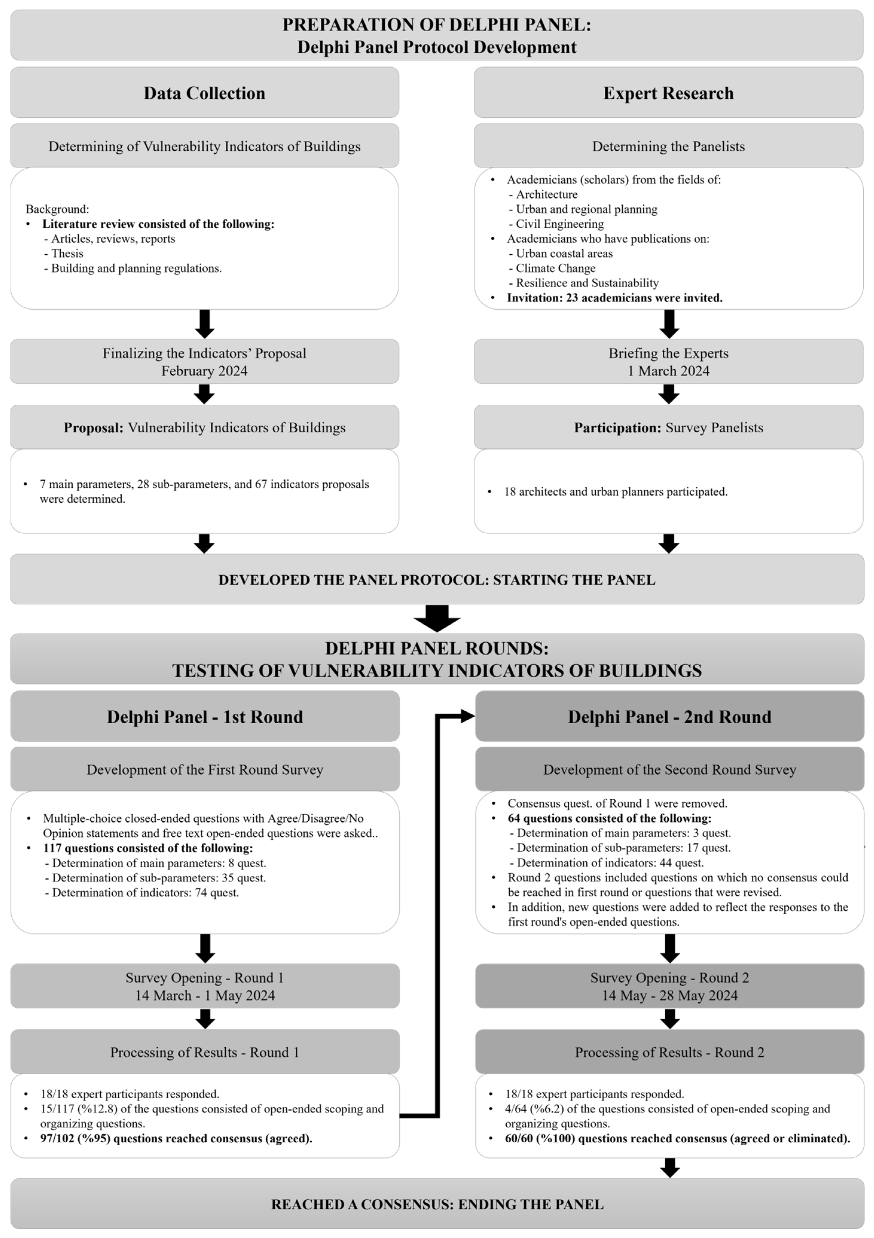
2.1. Survey Design: Study Protocol and Data Collection

Establishing a comprehensive vulnerability assessment framework for buildings requires a clear understanding of the damage that could result from sea-level rise and flood hazards. In this section of the study, first, the factors that contribute to potential damage to buildings in urban coastal areas due to sea-level rise and flood hazards are presented through a literature review. Following the literature review, the damage risks associated with these contributing factors were identified and categorized. Then, these damage risks are analyzed and the parameters affecting the damage risk level are presented. These parameters, defined as design-induced vulnerability parameters, were further analyzed, and sub-parameters along with indicators (that can be utilized in assessing vulnerability levels of buildings) were determined. A list of parameters and indicators was prepared using data from the reviewed sources.
The data gathered from the literature review and subject to different interpretations were synthesized into a table and submitted for expert opinions. The Delphi method, recognized as a consensus-seeking approach, was employed to solicit expert feedback. Thus, the Delphi method was used to reach a consensus on the criteria that were proposed in the context of this research to be used in building vulnerability assessments (Figure 1).

2.2. Method

2.2.1. Determining the Indicators from the Literature Review

In the first part of the study, an attempt has been made to create a vulnerability assessment framework that can be used as a roadmap against climate change-induced sea-level rise and flood hazards in urban coastal areas, using the relevant institutions in disaster risk reduction (DRR) activities or by architects in building design in coastal areas.
This study, which is conducted as a vulnerability assessment, covers the built environment in urban coastal areas; buildings and urban infrastructure consisting of individual structures. Rural areas, archaeological sites, and historic cities are determined to be out of the scope of this research. It takes into account structural and material vulnerabilities of buildings. Although social vulnerabilities, governance, and management issues are important aspects of sea-level rise and flood vulnerabilities, they are also treated as beyond the scope of this study.

2.2.2. The Delphi Method

The second part of the study consists of testing the vulnerability indicators that were derived from the literature review. In this stage, as a study method, the Delphi method, which is used in data collection and decision-making processes with expert participation, was applied. There are studies in which the Delphi method is applied in research on urban coastal areas [72] and it is used to evaluate the future state of urban coastal areas in the context of climate change [73].
The Delphi method is often preferred in the literature on vulnerability to sea-level rise and flood hazards because it provides an effective approach for gathering, analyzing, and reaching consensus on expert opinions in a systematic, anonymous, and repeatable manner [74]. The Delphi method enhances scientific robustness with advantages such as anonymity, feedback loops, and reproducibility [75]. It also provides comprehensive and reliable results by bringing together multidisciplinary expert contributions on complex environmental problems that require prediction, such as sea-level rise and flooding [76]. In this study, the Delphi method was preferred because the independent and anonymous responses of experts to open-ended and closed-ended question types provided a more comprehensive assessment while determining the vulnerability indicators of buildings.
The Delphi method is defined as a method that brings together expert opinions through interviews with a group of experts to solve a complex problem [77]. Described as a flexible research method, Delphi can transform the subjective judgments of experts into collective objective results [78].
In the traditional Delphi method, a questionnaire is designed and sent to the participants. The results of the answered questionnaires are evaluated and summarized. According to the results, a new questionnaire is developed and presented to the participants. Group evaluations are also shared with all participants, and they are given one or more opportunities to re-evaluate their answers until a consensus is reached [77].
During the analysis of survey results, the percentage of experts agreeing on a particular opinion or the Kendall’s coefficient of concordance is utilized to determine whether consensus has been achieved [78]. Another method for determining consensus is to use the interquartile range [79].
In order to make a scientific assessment with the indicators determined against sea-level rise and flood hazards, it is necessary to reach a consensus on the indicators with experts. For this reason, these vulnerability indicators of buildings, which were created through literature research in the relevant field, were presented to the expert opinions as a list using the Delphi method. In decision-making processes, Delphi is a method to take the opinions of experts who have worked on a specific subject. The subject area for this study encompasses urban coastal areas, climate change, resilience, and/or sustainability.

2.2.3. Delphi Panelists

The Delphi method is characterized by its interdisciplinary perspective, anonymity, and the aim of reaching consensus with expert participants in an unbiased manner [75]. As the Delphi method is based on expert opinion, it may introduce elements of subjectivity and bias into the process. In this study, certain criteria [77] were adopted for the selection of experts in order to minimize the subjectivity of the method and increase the reliability of the results. These criteria are designed to ensure that the experts are academics who have publications in the fields of ‘Urban Coastal Areas’, ‘Climate Change’, ‘Resilience and Sustainability’, that the majority of them have at least five years of experience in the relevant fields, and that they come from different disciplines and cities. Thus, it is aimed to reach an unbiased evaluation by providing an interdisciplinary perspective and geographical diversity. Since the criteria in the evaluation framework of the study were limited to the building and its immediate surroundings within the framework of the discipline of architecture and related fields, academics from the fields of urban and regional planning, civil engineering, and mostly from the field of architecture were invited. This approach was an important step to increase the reliability of the process of selecting vulnerability indicators.
The choice of only academics as the expert group of the study is a methodologically conscious choice, as academics are a group that is likely to meet the established criteria of expertise and can increase the scientific validity of the consensus. As the aim of the Delphi method is to reach a reasonable degree of consensus, it is recommended to organize independent panels that separate the stakeholder groups. This design also allows the perspectives of different stakeholder groups to be compared [75].
It is recommended that the size of each panel should be between 10 and 18 people for expert surveys using the Delphi method [75]. Therefore, in this study, invitations were first sent to 16 experts. At this stage, only 11 individuals responded affirmatively. Consequently, invitations were extended to 12 additional experts, and affirmative feedback was received from seven more experts. Thus, it was decided to proceed with a group of 18 experts among the 28 invited participants. In other words, a 64% affirmative response rate was achieved from the invited expert group. As the number of participants increases in qualitative approaches, difficulties arise in data processing and analysis [80]. Reaching the limit of 18 participants supported methodological consistency and reduced the effect of individual bias in the group.
From the group of 18 experts formed for the panel, 15 (83%) were from the field of architecture and three (17%) from the field of urban and regional planning. In this expert group, there are seven professors (39%), two associate professors (11%), seven assistant professors (39%), one research assistant PhD (5.5%), and one lecturer PhD (5.5%). Additionally, 12 (67%) of the experts were female and six (33%) were male. The majority of participants 17 (94.5%) were from Türkiye, while one expert (5.5%) was from the Netherlands. The distribution of the experts’ professional experience shows that 10 (55%) have over 20 years of experience, three (17%) have 16–20 years, and five (28%) have 11–15 years. Regarding their field-specific experience, four (22%) have been working in their field for over 20 years, two (11%) for 16–20 years, three (17%) for 11–15 years, four (22%) for 6–10 years, and five (28%) for 1–5 years.
  • Invitation: Briefing the experts
Before sending the questionnaire, the prospective participants were informed about the content and process planning of the study via e-mail (Figure 1). The expert survey was prepared electronically as a Google Form and the survey link address was sent via e-mail to all experts who responded positively to the invitation e-mail.
  • Explanation: Survey
For both rounds of the study, the experts were asked whether the parameters or indicators mentioned in that question could be used as criteria for assessing vulnerability indicators of buildings in urban coastal areas (to SLR and flooding). Then, the experts were presented with multiple-choice closed-ended questions to choose between ‘Agree’, ‘Disagree’, ‘No Opinion’ (Figure 1). ‘Agree’ and ‘Disagree’ responses do not have a rating within themselves. Therefore, the evaluation was carried out directly by seeking consensus on one of the ‘Agree’ or ‘Disagree’ statements. When analyzing the data for the first- and second-round Delphi questionnaires, the limit of consensus among the participants’ responses was 65% (an approx. two-thirds majority). The questionnaire included not only closed-ended questions, but also open-ended questions, allowing the participating experts to present their opinions.

3. Determining the Vulnerability Indicators of Sea-Level Rise and Flood Damage for Buildings

As a result of the direct or indirect negative effects of sea-level rise and floods, buildings are damaged in urban coastal areas. This damage emerges as a result of internal and external factors that may manifest rapidly or gradually. The factors that contribute to this damage to buildings which differ according to environmental data can be listed as: excessive buoyancy force of the water, high-speed dynamic flow, horizontal hydrostatic pressure, upward hydrostatic pressure, barrier formation, the dynamic effect of floating objects, transportation of ice masses, water absorption of materials, contamination of materials with pollutants, deterioration of foundation materials, mechanical changes in soil properties, erosion (coastal or internal), groundwater effects, and post-flood effects [38,57]. These factors can cause damage individually, or they can combine to cause greater damage.
The frequency and characteristics of damage to buildings due to sea-level rise and flooding can intensify. Since it is not feasible to cover all potential impacts within the scope of this study, the damage inflicted by sea-level rise and flooding on buildings in urban coastal areas is categorized according to the underlying causal factors. Based on the conducted research, the damage risks associated with these factors and the determinants (parameters) affecting the level of damage risk are summarized in Table 1.
When the damage risks given in Table 1 are analyzed, it is understood that not every building will have the same risk of SLR and flood damage, and the existing qualitative/quantitative characteristics and condition of the building will affect the damage level. Accordingly, the eight parameters affecting the damage level are urban design regulations, landscape and building design regulations, building structural system design, building design, detail design, interior design, site usage, building condition. These parameters that are derived from literature analysis were transformed into vulnerability parameters to be used in the model.
In the model proposed to assess the vulnerability of buildings in urban coastal areas, it is necessary to determine the vulnerability indicators in order to evaluate the level of vulnerability to SLR and flooding. In this section, design-induced vulnerability parameters are presented and indicators that depend on these parameters which can be used in the assessment of vulnerability levels of buildings are determined. The relationship between eight parameters obtained from the findings in Table 1 and vulnerability of buildings is defined below.

3.1. Urban Design Regulations Indicators

The vulnerability of urban coastal areas can be reduced by addressing urban design regulations with planning strategies appropriate to local conditions, considering the physical, economic, and ecological dynamics of the city. Urban block sizes and building density can increase flood risk by affecting water movement and drainage within the city [81]. Infrastructure measures such as dikes, ditches, and roads contribute to controlling water and reducing flood risks. If these infrastructures are not planned correctly, they may be insufficient in case of excessive rainfall and coastal areas may be damaged [82]. Vulnerability indicators of buildings associated with the ‘urban design regulations’ parameter are presented in Table 2 as: set, set height, floodwall, floodwall height, breakwater, breakwater height, trench, trench size, road type, pedestrian emergency escape route, pedestrian emergency escape route height, pavement, pavement height, pavement width, vehicle road, vehicle road width, and urban block size.

3.2. Landscape and Building Design Regulations Indicators

In the context of reducing vulnerabilities to sea-level rise and flood risk in urban coastal areas, landscape and building design regulations are important as one of the first points of resistance against these hazards. The location and altitude of buildings directly affect flood risk in relation to sea-level rise [83]. Landscape designs of buildings in settlements close to the coast can increase flood risks with the degree of proximity to water [84].
While landscape elements, especially those (garden walls, embankments, etc.) used for defense and protection, provide protection against floods, they can also increase risks when these structures are not positioned correctly [85,86]. While the placement and elevation of buildings are of primary importance against flooding and sea water rise, these risks can be reduced through strategic planning [87]. Vulnerability indicators of buildings associated with the ‘landscape and building design regulations’ parameter are presented in Table 2 as: border wall, border wall height, border wall aperture, green area ratio, permeable surface ratio, site selection (building/construction site), building coverage ratio (BCR), building floor area ratio (FAR), building orientation, adjacent/separate regularization status, location of the buildings on the urban block relative to each other, and building entrance elevation (altitude of road elevation).

3.3. Building Structural System Design Indicators

The vulnerability of buildings in urban coastal areas to sea-level rise and flooding depends to a large extent on the design of building structural systems. Indicators such as the material of the buildings, type of structural system, and waterproofing properties, etc., play an important role in protecting against such environmental threats. Waterproof materials used in the structural systems of buildings in areas prone to sea-level rise and flood risk make them more resilient to flooding from these climate hazards [88]. In Scussolini et al. (2017), simplified structural models developed for traditional buildings show how such buildings can be retrofitted against flooding [89]. In modern coastal cities, new mathematical approaches and engineering methods are used to mitigate the impacts of sea-level rise and flooding on buildings [90,91]. These interdisciplinary approaches are thought to contribute to the safer design of buildings. In order to reduce the vulnerability of buildings in the context of sea-level rise and floods, the design of the structural system should be planned correctly. The proposal to include ‘building structural system design’ as a parameter emerged following the first round. This parameter was added here as a parameter due to the fact that its indicators are included in the proposed list.

3.4. Building Design Indicators

For buildings in urban coastal areas, vulnerability to sea-level rise and flooding is closely related to the design of building components. Building foundations should be reinforced to ensure the water resistance of the ground. Tall buildings and water-resistant exterior cladding increase resistance to flooding. Roofs, floors, and walls should be designed to minimize water permeability, while joinery and windows should be selected from materials that prevent water infiltration. In addition, the height and width of wall openings can also minimize damage to the building [92]. Building height and form should also be planned to reduce the pressure of water on the building [88,93,94]. Vulnerability indicators of buildings associated with the ‘building design’ parameter are presented in Table 2 as: structure anchoring (fixing), building ground-floor elevation, ground-floor wall openness/solid ratio, number of building floors (building height), building form, building material, building structural system, exterior walls, roof, doors, windows, areaway, areaway volume, basement floor, and basement floor opening.

3.5. Detail Design Indicators

The design of building installation and insulation details is necessary to reduce the vulnerability of buildings to sea-level rise and flooding in urban coastal areas. Studies show that drainage systems, flood vents, flood barriers, and building installations significantly affect the vulnerability of buildings. Appropriate drainage systems that consider environmental conditions allow flood waters to drain quickly, while flood vents prevent water from damaging the structure [95]. Insulating building installations with waterproof materials and planning control points in appropriate locations reduces post-flood maintenance costs and increases the resilience of buildings [96]. Physical measures such as flood barriers greatly reduce the risk of buildings being directly affected by floods [94]. All these measures contribute to building resilience in reducing building vulnerability in urban coastal areas. Vulnerability indicators of buildings associated with the ‘detail design’ parameter are presented in Table 2 as: wall joints, flood barrier, drainage systems, flood vents, installation system (gas, air cond., water, electricity, meter, fuse, socket), and control points.

3.6. Interior Design Indicators

Factors such as the interior wall materials and claddings of buildings, the body height and body material of fixed furnishings can determine the degree of water damage to buildings. As an example, Balasbaneh et al. (2020) found that concrete block walls and pre-cast concrete frames are more resistant to flood water than wooden walls [97]. According to Sani et al. (2014), apart from building elements, furniture can also minimize the damage to the building [98]. These factors in building interior design determine the vulnerability of coastal buildings. Choices here can prevent buildings from further increasing their resilience to flood damage. Vulnerability indicators of buildings associated with the ‘interior design’ parameter are presented in Table 2 as: safety stairs, floor, wall, furnishing—height, and furnishing—material.

3.7. Site Usage Indicators

The vulnerability of buildings in urban coastal areas to sea-level rise and flooding varies according to the function of the buildings. In this context, it is necessary to mention the vulnerability of each type of building to flood risk.
  • Residential buildings are among the most vulnerable to sea-level rise and flooding because they often have inadequate protection measures [99];
  • Commercial and industrial buildings face flood risks that affect the sustainability of commercial activities, which can lead to economic losses and dysfunction [99];
  • Tourism buildings are at serious risk from flooding and erosion due to their proximity to the coast, which can lead to losses in tourism revenues [100];
  • Health buildings are of great importance as they can lose their functionality in times of crisis and increase public health risks [101];
  • As cultural, artistic, and worship buildings are often of historical and spiritual value, their protection from floods is important to prevent long-term cultural losses [19];
  • Transportation buildings, roads. and bridges can be severely damaged in floods, cutting off emergency transportation routes and disrupting rescue operations [29];
  • Strategic buildings (e.g., military bases) can pose security risks and disrupt the functioning of state institutions when they cease to function [102];
  • When educational buildings are damaged during events such as floods, educational processes may stop and students’ safety may be jeopardized [103];
  • Structural elements in public open spaces, such as parks and public squares, can suffer severe structural damage, jeopardizing public safety [104].
The functions of buildings have an important role in the planning of urban coastal areas. Functions directly or indirectly affect structural decisions in many areas from site selection to building dimensions, from structural systems to material choices. Residential buildings in terms of the purpose of ground floor use; commercial and industrial buildings in terms of the properties of the materials and equipment they contain; tourism buildings in terms of the density of construction in coastal areas; health buildings in terms of the units they contain and their accessibility; culture/art/entertainment and worship buildings in terms of the valuable assets they contain; transportation structures in terms of the availability of alternatives in urban transportation; infrastructure and strategic structures in terms of the functioning of systems such as defense, energy, waste, and transportation; educational structures in terms of the different sensitivities of different age groups; building elements in public open spaces affect vulnerabilities in urban coastal areas in terms of their stability and their positive or negative effects on exposures in built environments. Furthermore, when making a land use decision on a specific area in coastal areas, climate change-induced hazards should be taken into account, because the coexistence of a certain functional group in coastal areas vulnerable to climate change-induced hazards may increase the level of vulnerability through compound vulnerabilities by causing social vulnerabilities as well as structural vulnerabilities due to the function of the structures. Vulnerability indicators of buildings associated with the ‘site usage’ parameter are presented in Table 2.

3.8. Building Condition Indicators

Since the age of buildings is often associated with material deterioration, reduced structural strength, and lack of maintenance, the older the building, the greater its vulnerability to climatic impacts such as sea-level rise. Older buildings may face problems such as corrosion of building materials or reduced concrete strength, which can lead to higher damage during flooding [105]. Poorly maintained or damaged buildings are less resistant to sea flooding [99]. The height and specifications to which the building was built when it was first constructed also affect resilience [10]. Vulnerability indicators of buildings associated with the ‘building condition’ parameter are presented in Table 2 as: construction date (building age) and building/structure damage level.
The factors included in the vulnerability parameters of buildings will affect the level of vulnerability. Therefore, these factors have been transformed into vulnerability indicators of buildings as indicators that can be used in vulnerability assessments of buildings (Table 2).
Table 2. A proposal for vulnerability assessment of buildings.
Main ParametersSub-ParametersVulnerability Indicators of BuildingsSources
SITE DESIGNURBAN DESIGN REGULATIONSSet or SeawallSet[41,81,82,106]
Set Height
FloodwallFloodwall
Floodwall Height
BreakwaterBreakwater
Breakwater Height
Trench or CulvertTrench
Trench Size
Transportation DiversityRoad Type
Pedestrian WayPedestrian Emergency Escape Route
Pedestrian Emergency Escape Route Height
Pavement
Pavement Height
Pavement Width
Vehicle RoadVehicle Road
Vehicle Road Width
Urban BlockUrban Block Size
LANDSCAPE AND BUILDING DESIGN REGULATIONSBorder WallBorder Wall[38,40,41,83,84,85,86,87,106,107]
Border Wall Height
Border Wall Aperture
Building LandscapeGreen Area Ratio
Permeable Surface Ratio
Building LocationSite Selection (Building/Construction Site)
Building LayoutBuilding Coverage Ratio (BCR)
Building Floor Area Ratio (FAR)
Building Orientation
Adjacent/Separate Regularization Status
Location of the Buildings on the Urban Block Relative to Each Other
Building AltitudeBuilding Entrance Elevation (Altitude of Road Elevation)
BUILDING DESIGNFoundationStructure Anchoring (Fixing)[38,41,57,88,89,90,91,92,93,94,106,107,108,109,110]
Ground FloorBuilding Ground Floor Elevation
Ground Floor Wall Openness/Solid Ratio
FormNumber of Building Floors (Building Height)
Building Form
MaterialBuilding Material
Building StructureBuilding Structural System
Building EnvelopeExterior Walls
Roof
Doors
Windows
Underground StructureAreaway
Areaway Volume
Basement Floor
Basement Floor Opening
DETAIL DESIGNDry WaterproofingWall Joints[94,95,96,107]
Flood Barrier
Wet WaterproofingDrainage Systems
Flood Vents
Installation System (Gas, Air Cond., Water, Electricity, Meter, Fuse, Socket)
Control Points
INTERIOR DESIGNIndoor SafetySafety Stairs[88,97,98]
Internal SurfaceFloor
Wall
Interior FurnishingFurnishing—Height
Furnishing—Material
SITE USAGELand UseResidential Buildings[19,29,99,100,101,102,103,104,106]
Commercial and Industrial Buildings
Tourism Buildings
Health Buildings
Culture/Art/Entertainment and Worship Buildings
Transportation Structures
Infrastructure and Strategic Buildings
Education(al) Buildings
Agriculture(al) Area
Public Buildings and Building Elements in Public Open Spaces
BUILDING CONDITIONBuilding AgeConstruction Date (Building Age)[10,99,105,106]
Building Damage Cond.Building/Structure Damage Level

4. Expert Opinions on Vulnerability Evaluation of Buildings

4.1. Results of the First Round of the Delphi Survey

The first round of the Delphi survey consists of 117 questions. Of these 117 questions, eight questions were designed to identify main parameters, 35 questions were designed to identify intermediate parameters, and 74 questions were designed to identify indicators. Fifteen (13%) of the 117 questions consisted of open-ended scoping and organizing questions. Of the remaining 102 closed-ended questions, 97 (95%) were agreed upon. At the end of the first round, responses were received from 18 participants (Table 3).
In the first round, consensus was reached on all responses except for five criteria. These five criteria are: the main parameter ‘interior design’, the sub-parameters ‘interior safety’, ‘interior surfaces’, ‘interior fittings’, and the indicator ‘agricultural areas’.
For the main parameter ‘interior design’, eight respondents selected ‘Agree’, six selected ‘Disagree’ and four selected ‘No Opinion’. In this parameter, the consensus threshold was not surpassed (8/18 = 44% < 65%), and even the majority of the participants disagreed or remained undecided. The experts did not see a direct link between interior design and building vulnerability, as they thought that the first areas to be damaged by sea-level rise and flooding would be the perimeter, foundation, and building envelope. Therefore, the main parameter ‘interior design’ was left to the second round.
Participants expressed a similar opinion for the sub-parameters ‘interior safety’, ‘interior surfaces’, and ‘interior fittings’, which are connected to the parameter ‘interior design’. For all three sub-parameters, nine respondents selected ‘Agree’ and a total of nine respondents selected ‘Disagree’ or ‘No Opinion’. Therefore, 50% for ‘indoor safety’, 50% for ‘interior surfaces’, and 50% for ‘interior fittings’ did not exceed the consensus limit.
For the ‘agricultural areas’ indicator, 11 respondents selected ‘Agree’ and seven selected ‘Disagree’, which is below (61%) the consensus limit. Participants did not consider it necessary to include areas with this function in vulnerability assessments, as the building density is generally low in agricultural areas.
In advance of the second round, certain parameter names were modified in accordance with the recommendations put forth by the experts. The parameter name ‘urban design regulations’ was revised to ‘urban design and infrastructure regulations’; the parameter name ‘landscape and building design regulations’ was revised to ‘landscape design and spatial configurations within the site’; the parameter name ‘building design’ was revised to ‘building components design’; the parameter name ‘detail design’ was revised to ‘building systems and insulation design’; the parameter name ‘interior design’ was revised to ‘building interior design’; the parameter name ‘site usage’ was revised to ‘building function’; and the parameter name ‘building condition’ was revised to ‘building age and condition’ in the second round based on suggestions. Additionally, the proposal to include ‘building structural system design’ as a parameter emerged.
At the beginning of the second round, the questions on which consensus was reached in the first round were removed. The second round consisted of 64 questions. Of these 64 questions, three questions were designed to determine main parameters, 17 questions were designed to determine sub-parameters, and 44 questions were designed to determine indicators. The second-round questions included only the questions that were not agreed upon in the first round, new criteria suggestions, and revised criteria. In the second round of the survey, the first-round results were presented to the participants using graphs. The 65% consensus limit accepted for the Delphi method was added to the graphs. When a response was above the consensus limit in the graph, it meant that the participants agreed on the acceptance or elimination of that criterion.
Feedback was provided on all criteria with objective, detailed explanations for each question. Accordingly, they were asked to review their responses in the first round in order to reach a consensus on the acceptance or elimination of the criteria. In addition, new questions were added to reflect the responses to the open-ended questions in round one.
Building structural system design, which was only considered as a sub-parameter in the first round, has been addressed more comprehensively as a main parameter since it is one of the most important parameters for building durability. Since many changes and additions were made to the indicators within the scope of the main parameters of building structural system design and building component design, expert opinion was again obtained on all indicators related to this parameter.

4.2. Results of the Second Round of the Delphi Survey

At the end of the second round, responses were received from 18 participants. Of the 64 questions in the second round, four (6%) were open-ended scoping and editing questions. For the remaining 60 closed-ended questions (100%), consensus was reached on acceptance or elimination (Table 4).
The participants demonstrated a consistent viewpoint regarding the sub-parameters of ‘dry waterproofing’ and ‘wet waterproofing’ within the main parameter of ‘design of building installation and insulation details.’ Specifically, for both sub-parameters, two respondents indicated ‘Agree’, 12 respondents selected ‘Disagree’, and four respondents chose ‘No Opinion’. As a result, the consensus threshold for elimination was surpassed, with a disagreement rate of 67% concerning the inclusion of the ‘dry waterproofing’ and ‘wet waterproofing’ sub-parameters.
For the sub-parameter ‘land use’ of the main parameter ‘building function’, three participants expressed ‘Agree’, while 14 participants indicated ‘Disagree’, and one participant chose ‘No Opinion’. Given that the consensus threshold was surpassed (78%), an agreement was reached to eliminate this sub-parameter.
Regarding the sub-parameters ‘building age’ and ‘building damage condition’ of the main parameter ‘building age and condition’, four respondents selected ‘Agree’ while 14 selected ‘Disagree’. The consensus threshold for elimination was surpassed (78%), with the majority of participants expressing disagreement. Consequently, experts concurred on the removal of the sub-parameters, given that only a single indicator was associated with them.
The transportation sub-parameters of the main parameter ‘urban design and infrastructure regulations’ were combined at the beginning of the second round. Three participants selected ‘Agree’ and 15 participants selected ‘Disagree’ for the indicators of the sub-parameter ‘transportation routes’, which are ‘road type’, ‘pedestrian emergency escape route’, ‘pedestrian emergency escape route height’, ‘pavement’, and ‘vehicle road’.
With most respondents expressing disagreement, the consensus threshold for elimination was surpassed.
Participants expressed similar opinion for the ‘safety stairs’ and ‘floor’ indicators, which are related to the ‘interior design’ parameter. For the ‘safety stairs’ indicator, two participants selected ‘Agree’, 15 participants selected ‘Disagree’ and one participant selected ‘No Opinion’. For the ‘floor’ indicator; two participants selected ‘Agree’ and 16 participants selected ‘Disagree’. Therefore, with 83% for ‘safety stairs’ and 89% for ‘floors’, these indicators were agreed to be eliminated.
For the ‘agricultural areas’ indicator, one respondent selected ‘Agree’ and 16 selected ‘Disagree’, and one respondent selected ‘No Opinion’. The consensus threshold for elimination was surpassed (89%) for ‘agricultural areas’ and it was agreed to be eliminated. Participants did not consider it necessary to include areas with this function in vulnerability assessments, as the building density is generally low in agricultural areas.
In the process of developing the proposed vulnerability assessment framework, new proposals were submitted and accepted in addition to the parameters and indicators that were agreed to be accepted or eliminated. For the main parameter of urban design and infrastructural regulations, the sub-parameters were grouped according to the areas in which they are located and the indicators related to transport were gathered under a single sub-parameter. For the main parameter of landscape design and spatial configurations within the site, the sub-parameters of building location and building layout were combined and new indicators were added. It has been suggested that the structural system design should be added as a main parameter and the basic sub-parameter should be detailed by taking the basic sub-parameter into this category and indicators have been added in this direction. Suggestions regarding the grouping of sub-parameters for the main parameter of building components design and the elaboration and increase in indicators were taken into consideration and included in the evaluation. Sub-parameters for the main parameter of building systems and insulation design were removed. For the design of building interiors, it was suggested and accepted to remove the indicators that are considered to be evaluated other than structural and material vulnerabilities. Sub-parameters for the main parameter of building function, building age, and current condition were removed. In addition, proposals for naming changes in each parameter and indicator group were also implemented. These processes resulted in the finalized assessment framework (Table 5).
It is thought that the reason for reaching consensus on all the criteria in the second round is that both the subject matter and the Delphi method were more familiar. At the end of the second round, the Delphi session was terminated as consensus was reached on all parameters and indicators.

5. Results and Discussion

In this study, an outline for the assessment of vulnerability indicators of buildings subject to sea rise and flooding in urban coastal areas is proposed. The Delphi method was used to test and improve the proposed assessment framework. The Delphi method’s consensus building and openness to improvement provided results that helped to address the shortcomings and improve the evaluation framework proposal derived from the literature review. The results of the study provide important implications for the vulnerability assessment of buildings and present a basis for a comprehensive discussion. Based on the results of the Delphi process, discussions on the development of a vulnerability assessment framework are discussed below.
The analyses show that vulnerability assessments of buildings to sea-level rise and flood risks are assessed starting from urban design and infrastructure regulations to landscape design and building scale. Similarly, Dal Cin et al. (2021) emphasize that the analysis of urban vulnerability makes it possible to plan the adaptation of coastal areas through legal regulations, the construction of flood management infrastructure, and the design of public spaces that can accommodate water [84].
The results reveal that the ‘building material’ indicator, which is presented as a single indicator within the scope of the evaluation of building materials, is not sufficient for the vulnerability assessment of buildings. For this reason, the ‘building material’ indicator has been organized into indicators that are considered separately for each building element in the study process. These findings are in line with the results proposed by Wathier (2014), who suggested that optimization of parameters related to material selection in vulnerability assessments of buildings is an effective strategy to reduce flood damage [111]. The results emphasize that material decisions in different building elements and details have an important place in the vulnerability assessments of buildings. The key findings of Azmeri et al. (2020) also support this; structural and architectural elements have a significant impact on post-flood repair costs. Therefore, insulating structural elements and building installations with waterproof materials and planning check points in appropriate locations will reduce post-flood maintenance costs and increase the durability of buildings [96].
Building storeys and building forms have a direct relationship with vulnerability, as they determine the proportion of the surface to be affected by hazards. The study by Milanesi et al. (2018) emphasizes the importance of considering building geometry and the physical durability of building elements in flood vulnerability assessments [88]. The high level of agreement for the building storey and building form vulnerability indicators is consistent with the study by Milanesi et al. (2018). Han and Mozumder (2021) state that flood vulnerability at the building-level can be significantly reduced through measures in single- and multi-storey buildings in coastal areas [112].
The fact that a consensus was reached on the building interior design parameter and its sub-parameters after the second round showed that the first areas to be damaged by sea-level rise and flooding are the immediate environment, foundation, and building envelope, and that damage to the interior can be partially ignored. It was recognized that ignoring the indicators for interior design would increase structural damage as it would mean ignoring the design of interior walls and fixed reinforcement [98].
The low level of consensus on the indicators for the building function parameter leads to important questions about whether the effects of this parameter are generalizable independently of the context of social vulnerability.
The indicators obtained in the study can be ranked by dividing them into levels according to their quantitative and qualitative characteristics, taking into account local conditions. This rating can be used as a guide for architectural decisions to be taken in the design, implementation, and retrofitting processes of buildings located in urban coastal areas. In addition, the assessments to be carried out based on the details of the building design can also determine effects of the differences in the quality or quantity of an indicator on vulnerability. In addition, weighting studies can be used to estimate which indicator, which sub-parameter, and which main parameter will have a greater impact on vulnerability. In this way, it can be determined which part of a building is more vulnerable, which building is more vulnerable on a site, or which site is more vulnerable in an urban coastal area. These findings will help policy makers and urban planners make decisions on how to ‘protect’, ‘accommodate’, and ‘retreat’.

6. Conclusions

Considering the projected sea-level rise and increasing flood risks driven by climate change, evaluating the costs associated with the necessary mitigation measures is important for the effective long-term planning of resilience of buildings. Moreover, factors such as the environmental compatibility of these climate resilient buildings and their associated costs play a role in shaping decision-making processes for their implementation. At this point, determining the vulnerabilities of buildings to climate change hazards in urban coastal areas will be guiding before deciding on the measures to be taken in coastal areas.
Analyses of classified flood-induced forces and risk situations provide preliminary information to minimize damage to buildings in urban coastal areas in the event of sea-level rise and flooding. These analyses guide both the identification of vulnerabilities and the planning of permanent or temporary measures. Preventive measures against natural disasters are seen as one of the most effective tools to reduce the impact of disasters. In order to take these preventive measures, it is necessary to identify vulnerabilities. This study contributes to the studies in this field by determining these indicators to reveal the vulnerability of buildings.
Indicators based on parameters such as the design of the building and its immediate surroundings, the function of the building, and the condition of the building will enable the identification of the location of vulnerability of buildings. Thanks to these determinations, it will be possible to take low-cost structural measures against climate-change hazards that may be experienced in the short term, compared to infrastructure measures taken in urban planning and engineering.
The assessment framework developed in this study is designed as a flexible and hierarchical tool and checklist to guide stakeholders involved in architectural design and urban planning processes in urban coastal areas. The checklist aims to facilitate the integration of vulnerability considerations into design processes from the conceptualization stage to the utilization stage. The hierarchical structure of the framework contributes to reducing site-specific vulnerabilities by prioritizing parameters and indicators according to environmental conditions and enables users to design and construct structures that are resilient to sea-level rise and flooding in different conditions.
The hierarchical structure of the framework is designed to be used throughout the design process, from fundamental decisions about the building and its environment to final implementation. The assessment framework can be used by urban planners to set design priorities in line with overarching resilience goals and integrate them into architectural processes. Architects can utilize the framework to prepare buildings for climate-related hazards by developing solutions starting from the urban scale. In addition, policy makers can refer to the framework when formulating legal and structural regulations that promote resilient construction.
In this direction, it is expected that the assessment framework can be used:
  • by policy makers as a checklist or a base for regional spatial planning, urban design, building standards, and the legal basis for zoning regulations (enactment of different zoning regulations in the case of low elevation coastal zones (LECZ-0-10m) etc.—‘governance’) by identifying vulnerabilities in urban coastal areas according to regional conditions;
  • by urban planners as a checklist or base for identifying vulnerabilities (not building or retreating infrastructure and strategic building areas in vulnerable coastal areas according to the predicted hazards) when making land use decisions for urban coastal areas in spatial planning processes;
  • by urban designers as a checklist or a base for designing building areas in coordination with their immediate surroundings in design processes, as resilient to sea-level rise and flood hazards, and for making existing designs resilient (making design decisions related to urban morphology, increasing the ratio of public open space or green space between the building and the coast in urban coastal areas etc.);
  • by architects as a checklist or basis for the preparation of resilient building designs (floodproof building designs such as elevated ground floor buildings, floating houses etc.—‘accommodate’) by identifying the vulnerability points in the buildings at the preliminary design stage and taking the necessary measures at these points;
  • as a checklist or basis by decision making bodies consisting of architects and engineers to review the existing built environment in urban coastal areas with vulnerability indicators and for disaster risk reduction activities for existing buildings (to establish flood resilient buildings in building renovations etc.—‘protect’ and ‘accommodate’).
In the future extension of the study, the vulnerability of buildings can be assessed using indicators that can serve as a checklist by grading the levels of the indicators, and the results of these assessments can be processed as data for data-driven and GIS-based studies. These data processed into GISs can be used as a data set in monitoring the vulnerability levels of buildings or sites in urban coastal areas and in the creation of vulnerability maps. These data sets and vulnerability maps can provide guidance to local governments in developing risk mitigation policies and to designers in production processes.
The vulnerability indicators of buildings determined by taking expert opinions and reaching consensus with the Delphi method may vary by repeating the research steps according to the risk status of climate change hazards projected for urban coastal areas under different conditions. In this direction, vulnerability levels and priorities of indicators can be determined according to local conditions. Thus, it can serve as a basis for vulnerability assessments of buildings to be made in coastal cities in the Mediterranean Basin, and can enable the formation of alternative assessment models compatible with local conditions.
As it is recommended to organize independent panels to achieve a reasonable degree of consensus in the Delphi method, this study was only applied to academics working in the fields of climate change, urban coastal areas, and sustainability. However, the study could be improved by organizing panels with other stakeholders, such as government agencies, local communities, practitioners, and environmental scientists, to provide practice-oriented perspectives. It can guide long-term zoning studies for urban coastal areas in local governments.
Although the locations of sea-level rise and flood hazard areas are generally known, the timing of the events is uncertain. Therefore, in addition to the structural and material assessments and analyses of buildings in this study, it is also necessary to deal with other challenges that accompany flooding events. Although beyond the scope of this study, it is also important to prepare risk management, evacuation, and rescue plans that can influence the magnitude of damage and losses to the built environment. In this respect, socio-economic and governance vulnerabilities also need to be assessed in order to be able to talk about an overall vulnerability assessment. In future studies, it will be possible to make an integrated assessment of urban coastal areas by combining all these dimensions of the subject.

Author Contributions

Conceptualization, İ.Ç.; methodology, İ.Ç.; analysis, İ.Ç.; investigation, İ.Ç.; resources, İ.Ç.; data curation, İ.Ç.; writing—original draft preparation, İ.Ç.; writing—review and editing, İ.Ç. and A.C.; visualization, İ.Ç.; supervision, A.C.; PhD thesis and this manuscript advisor, A.C. Google Forms was used to create Delphi panel surveys. Microsoft Excel was used to create analysis graphs. This article is based on the Ph.D. Dissertation of İ.Ç. entitled Development of a Decision Support System for Architectural Design Strategies in Adaptation of Urban Coastal Areas to Climate Change, which was prepared under the supervision of A.C. (Ph.D. Dissertation, Yıldız Technical University, Istanbul, Turkey, 2024). All authors have read and agreed to the published version of the manuscript.

Funding

This research did not receive any direct external funding, but was developed from a doctoral/PhD thesis supported within the scope of the Doctoral Dissertation Support Program initiated by the Marmara Municipalities Union (MMU) in order to disseminate the solution proposals produced in scientific studies to urban problems for the present and future of the Marmara Region at the local government level. For more info about MMU: https://www.marmara.gov.tr/en/who-we-are (accessed on 3 November 2024).

Institutional Review Board Statement

This study uses the Delphi method, which is based on expert opinions. Thus, the study require ethical approval. The study was conducted in accordance with the Declaration of Helsinki, and the protocol was approved by the Social and Humanities Research Ethics Committee of Graduate School of Social Sciences (etik.yildiz.edu.tr/dogrula; Report No: 20240202711; Verification Code: b5f4f) on 24 February 2024 (meeting number: 2024.02).

Informed Consent Statement

Informed consent for participation was obtained from all subjects involved in the study.

Data Availability Statement

Data are contained within the article. Sharing with the publisher is only possible if deemed necessary (for the purpose of verifying the accuracy of the survey and provided that it is not shared with third parties).

Acknowledgments

We thank the researchers who participated in the Delphi survey for their great contributions to the study.

Conflicts of Interest

The authors declare no conflicts of interest. The funders had no role in the design of the study; in the collection, analyses, or interpretation of data; in the writing of the manuscript, or in the decision to publish the results.

References

  1. Neumann, B.; Vafeidis, A.T.; Zimmermann, J.; Nicholls, R.J. Future coastal population growth and exposure to sea-level rise and coastal flooding-a global assessment. PLoS ONE 2015, 10, e0118571. [Google Scholar] [CrossRef]
  2. Nicholls, R.J. Coastal flooding and wetland loss in the 21st century: Changes under the SRES climate and socio-economic scenarios. Glob. Environ. Chang. 2004, 14, 69–86. [Google Scholar] [CrossRef]
  3. Nicholls, R.J.; Klein, R.J. Climate change and coastal management on Europe’s coast. In Managing European Coasts: Past, Present and Future; Springer: Berlin/Heidelberg, Germany, 2015; pp. 199–226. [Google Scholar] [CrossRef]
  4. Woodruff, J.D.; Irish, J.L.; Camargo, S.J. Coastal flooding by tropical cyclones and sea-level rise. Nature 2013, 504, 44–52. [Google Scholar] [CrossRef] [PubMed]
  5. Vousdoukas, M.I.; Mentaschi, L.; Voukouvalas, E.; Verlaan, M.; Jevrejeva, S.; Jackson, L.P.; Feyen, L. Global probabilistic projections of extreme sea levels show intensification of coastal flood hazard. Nat. Commun. 2018, 9, 2360. [Google Scholar] [CrossRef] [PubMed]
  6. Koshimura, S.; Hayashi, S.; Gokon, H. The impact of the 2011 Tohoku earthquake tsunami disaster and implications to the reconstruction. Soils Found. 2014, 54, 560–572. [Google Scholar] [CrossRef]
  7. Baykal, T.; Şener, E.; Terzi, Ö. Application of analytical hierarchy process for flood risk analysis: A case study in Küçük Aksu River Basin (Antalya, Turkey). Iran. J. Sci. Technol. Trans. Civ. Eng. 2023, 47, 2449–2466. [Google Scholar] [CrossRef]
  8. Aksoy, O.; Altaş, E.; Erken, K. Kentsel alanlardaki taşkın duyarlılığına karşı ekolojik peyzaj tasarım önerilerinin geliştirilmesi: Antalya, Kemer örneği. Doğal Afetler Ve Çevre Derg. 2023, 9, 152–167. [Google Scholar] [CrossRef]
  9. Cavaleri, L.; Bajo, M.; Barbariol, F.; Bastianini, M.; Benetazzo, A.; Bertotti, L.; Chiggiato, J.; Davolio, S.; Ferrarin, C.; Magnusson, L.; et al. The October 29, 2018 storm in Northern Italy–an exceptional event and its modeling. Prog. Oceanogr. 2019, 178, 102178. [Google Scholar] [CrossRef]
  10. Hatzikyriakou, A.; Lin, N. Assessing the vulnerability of structures and residential communities to storm surge: An analysis of flood impact during Hurricane Sandy. Front. Built Environ. 2018, 4, 4. [Google Scholar] [CrossRef]
  11. IPCC. Summary for Policymakers. In Climate Change 2021: The Physical Science Basis. Contribution of Working Group I to the Sixth Assessment Report of the Intergovernmental Panel on Climate Change; Masson-Delmotte, V., Zhai, P., Pirani, A., Connors, S.L., Péan, C., Berger, S., Caud, N., Chen, Y., Goldfarb, L., Gomis, M.I., et al., Eds.; Cambridge University Press: Cambridge, UK, 2021; In Press. [Google Scholar]
  12. EEA. Europe Environment Agency, Report No: 12/2020. 2020. Available online: https://www.eea.europa.eu/publications/urban-adaptation-in-europe (accessed on 10 September 2024).
  13. Azevedo de Almeida, B.; Mostafavi, A. Resilience of infrastructure systems to sea-level rise in coastal areas: Impacts, adaptation measures, and implementation challenges. Sustainability 2016, 8, 1115. [Google Scholar] [CrossRef]
  14. Aydın, Ö.; Sarı, R.M. İklim Değişikliği ve Mimarlık: Bilimsel Literatürün Bibliyometrik Analizi (1990–2021). Ege Mimar. 2022, 116, 66–73. [Google Scholar]
  15. Chen, W.; Wang, X.; Deng, S.; Liu, C.; Xie, H.; Zhu, Y. Integrated urban flood vulnerability assessment using local spatial dependence-based probabilistic approach. J. Hydrol. 2019, 575, 454–469. [Google Scholar] [CrossRef]
  16. Englhardt, J.; de Moel, H.; Huyck, C.K.; de Ruiter, M.C.; Aerts, J.C.; Ward, P.J. Enhancement of large-scale flood risk assessments using building-material-based vulnerability curves for an object-based approach in urban and rural areas. Nat. Hazards Earth Syst. Sci. 2019, 19, 1703–1722. [Google Scholar] [CrossRef]
  17. Malgwi, M.B.; Schlögl, M.; Keiler, M. Expert-based versus data-driven flood damage models: A comparative evaluation for data-scarce regions. Int. J. Disaster Risk Reduct. 2021, 57, 102148. [Google Scholar] [CrossRef]
  18. Rodríguez-Gaviria, E.M.; Ochoa-Osorio, S.; Builes-Jaramillo, A.; Botero-Fernández, V. Computational bottom-up vulnerability indicator for low-income flood-prone urban areas. Sustainability 2019, 11, 4341. [Google Scholar] [CrossRef]
  19. Wu, T. Quantifying coastal flood vulnerability for climate adaptation policy using principal component analysis. Ecol. Indic. 2021, 129, 108006. [Google Scholar] [CrossRef]
  20. Percival, S.; Teeuw, R. A methodology for urban micro-scale coastal flood vulnerability and risk assessment and mapping. Nat. Hazards 2019, 97, 355–377. [Google Scholar] [CrossRef]
  21. Cazenave, A.; Cozannet, G.L. Sea level rise and its coastal impacts. Earth’s Future 2014, 2, 15–34. [Google Scholar] [CrossRef]
  22. Hino, M.; Nance, E. Five ways to ensure flood-risk research helps the most vulnerable. Nature 2021, 595, 27–29. [Google Scholar] [CrossRef] [PubMed]
  23. McGranahan, G.; Balk, D.; Anderson, B. The rising tide: Assessing the risks of climate change and human settlements in low elevation coastal zones. Environ. Urban. 2007, 19, 17–37. [Google Scholar] [CrossRef]
  24. Le, T.D.N. Climate change adaptation in coastal cities of developing countries: Characterizing types of vulnerability and adaptation options. Mitig. Adapt. Strateg. Glob. Chang. 2020, 25, 739–761. [Google Scholar] [CrossRef]
  25. Leal Filho, W.; Modesto, F.; Nagy, G.J.; Saroar, M.; YannickToamukum, N.; Ha’apio, M. Fostering coastal resilience to climate change vulnerability in Bangladesh, Brazil, Cameroon and Uruguay: A cross-country comparison. Mitig. Adapt. Strateg. Glob. Chang. 2018, 23, 579–602. [Google Scholar] [CrossRef]
  26. Barbier, E.B. A global strategy for protecting vulnerable coastal populations. Science 2014, 345, 1250–1251. [Google Scholar] [CrossRef] [PubMed]
  27. Nicholls, R.J.; Cazenave, A. Sea-level rise and its impact on coastal zones. Science 2010, 328, 1517–1520. [Google Scholar] [CrossRef]
  28. IPCC. Summary for Policymakers. In Climate Change 2023: Synthesis Report. Contribution of Working Groups I, II and III to the Sixth Assessment Report of the Intergovernmental Panel on Climate Change; Core Writing Team, Lee, H., Romero, J., Eds.; IPCC: Geneva, Switzerland, 2023; pp. 1–34. [Google Scholar] [CrossRef]
  29. Zanetti, V.B.; de Sousa Junior, W.C.; De Freitas, D.M. A climate change vulnerability index and case study in a Brazilian coastal city. Sustainability 2016, 8, 811. [Google Scholar] [CrossRef]
  30. Young, A.F. Adaptation actions for integrated climate risk management into urban planning: A new framework from urban typologies to build resilience capacity in Santos (SP). City Territ. Archit. 2016, 3, 12. [Google Scholar] [CrossRef]
  31. Hinkel, J.; Lincke, D.; Vafeidis, A.T.; Perrette, M.; Nicholls, R.J.; Tol, R.S.J.; Marzeion, B.; Fettweis, X.; Ionescu, C.; Levermann, A. Coastal flood damage and adaptation costs under 21st century sea-level rise. Proc. Natl. Acad. Sci. USA 2014, 111, 3292–3297. [Google Scholar] [CrossRef]
  32. Adger, W.N.; Arnell, N.W.; Tompkins, E.L. Successful adaptation to climate change across scales. Glob. Environ. Chang. 2005, 15, 77–86. [Google Scholar] [CrossRef]
  33. Hallegatte, S.; Green, C.; Nicholls, R.J.; Corfee-Morlot, J. Future flood losses in major coastal cities. Nat. Clim. Chang. 2013, 3, 802–806. [Google Scholar] [CrossRef]
  34. Hanson, S.; Nicholls, R.; Ranger, N.; Hallegatte, S.; Corfee-Morlot, J.; Herweijer, C.; Chateau, J. A global ranking of port cities with high exposure to climate extremes. Clim. Chang. 2011, 104, 89–111. [Google Scholar] [CrossRef]
  35. Rosenzweig, C.; Solecki, W. Hurricane Sandy and adaptation pathways in New York: Lessons from a first-responder city. Glob. Environ. Chang. 2014, 28, 395–408. [Google Scholar] [CrossRef]
  36. Tol, R.S.; Klein, R.J.; Nicholls, R.J. Towards successful adaptation to sea-level rise along Europe’s coasts. J. Coast. Res. 2008, 24, 432–442. [Google Scholar] [CrossRef]
  37. Işıldar, H.T.; Ercoşkun, Ö.Y. Türkiye’nin Kıyı İllerinin Cbs İle Hasargörebilirliğinin Değerlendirilmesi. Çevre Şehir Ve İklim Derg. 2022, 1, 273–291. [Google Scholar]
  38. Erdoğan, B.G.; Ünal, Z.G. Mimari Mirasın Sel Riski Analizi İçin Bir Model Önerisi: Edirne II, Bayezid Külliyesi Sel Riski Analizi. Megaron 2021, 16, 367–384. [Google Scholar] [CrossRef]
  39. Akçabozan Taşkıran, A. New Heritage Management Approaches to Transboundary and Transnational Serial Heritage Areas: The Case of İğneada. Climate. Culture. Peace Conference. 2022, pp. 1–4. Available online: https://www.climateculturepeace.org/event/aa0e10db-006b-46ab-8012-f66df32d910b/case-studies?tm=SWyi9-wO7_rY27L261jMIaJbiL7ZQjiHmlq2mbaQUGo&locale=en-US (accessed on 9 November 2024).
  40. Aydın, M.B.S.; Erdin, H.E.; Kahraman, E.D. Mekansal Yapı Özellikleri Açısından İklim Değişikliğine Karşı Risk Taşıyan Bölgelerin Saptanması, İzmir Determination of Areas Vulnerable to Climate Change Due to Spatial Structure Characteristics. Izmir Plan. Derg. 2017, 27, 274–285. [Google Scholar] [CrossRef]
  41. Sılaydın, M.B.; Selçuk, İ.A.; Begeç, H.; Demircan, G. Morfolojik Özellikleri Bağlamında Gecekondu Alanlarının İklim Değişikliğine Karşı Kırılganlığı: Lale Mahallesi Örneği. Türkiye Kentsel Morfoloji Ağı 2023, 518–526. Available online: https://www.tnum.org.tr/index.php/tnum/article/view/322 (accessed on 9 November 2024).
  42. Partigöç, N.S.; Acer, E. Kentsel kıyı alanlarında iklim değişikliğinin etkilerinin incelenmesi: Kumbahçe Mahallesi (Bodrum) Örneği. JENAS J. Environ. Nat. Stud. 2022, 4, 225–242. [Google Scholar] [CrossRef]
  43. Tachir, G. Assessment of Regulations in Coastal Areas Based on Coastal Area Design Parameters: The Case of Gallipoli-Turkey. Gazi Univ. J. Sci. Part B Art Humanit. Des. Plan. 2023, 11, 659–674. [Google Scholar]
  44. Torabi, E.; Dedekorkut-Howes, A.; Howes, M. Adapting or maladapting: Building resilience to climate-related disasters in coastal cities. Cities 2018, 72, 295–309. [Google Scholar] [CrossRef]
  45. Sarkar, N.; Rizzo, A.; Vandelli, V.; Soldati, M. A literature review of climate-related coastal risks in the Mediterranean, a climate change hotspot. Sustainability 2022, 14, 15994. [Google Scholar] [CrossRef]
  46. Pilarczyk, K.W. Impact of the Delta Works on the recent developments in coastal engineering. Coast. Ocean. Eng. Pract. 2012, 1–37. [Google Scholar] [CrossRef]
  47. Van Veelen, P. Adaptive Planning for Resilient Coastal Waterfronts: Linking Flood Risk Reduction with Urban Development in Rotterdam and New York City. Ph.D. Thesis, Delft University of Technology, Delft, The Netherlands, 2016. [Google Scholar] [CrossRef]
  48. Kabat, P.; Van Vierssen, W.; Veraart, J.; Vellinga, P.; Aerts, J. Climate proofing the Netherlands. Nature 2005, 438, 283–284. [Google Scholar] [CrossRef]
  49. Camuffo, D. Perception and Reality: How the Depths of the High Waters in Venice Apparently Change with the Reference System. Climate 2024, 12, 62. [Google Scholar] [CrossRef]
  50. Vitale, C.; Meijerink, S.; Moccia, F.D. Urban flood resilience, a multi-level institutional analysis of planning practices in the Metropolitan City of Naples. J. Environ. Plan. Manag. 2023, 66, 813–835. [Google Scholar] [CrossRef]
  51. El-Raey, M.; Dewidar, K.R.; El-Hattab, M. Adaptation to the impacts of sea level rise in Egypt. Mitig. Adapt. Strateg. Glob. Chang. 1999, 4, 343–361. [Google Scholar] [CrossRef]
  52. Frihy, O.; Mohamed, S.; Abdalla, D.; El-Hattab, M. Assessment of natural coastal hazards at Alexandria/Nile Delta interface, Egypt. Environ. Earth Sci. 2021, 80, 3. [Google Scholar] [CrossRef]
  53. Nóblega Carriquiry, A.; Sauri, D.; March, H. Community involvement in the implementation of sustainable urban drainage systems (SUDSs): The case of Bon Pastor, Barcelona. Sustainability 2020, 12, 510. [Google Scholar] [CrossRef]
  54. Locatelli, L.; Guerrero, M.; Russo, B.; Martínez-Gomariz, E.; Sunyer, D.; Martínez, M. Socio-economic assessment of green infrastructure for climate change adaptation in the context of urban drainage planning. Sustainability 2020, 12, 3792. [Google Scholar] [CrossRef]
  55. Thoidou, E. Spatial planning and climate adaptation: Challenges of land protection in a peri-urban area of the mediterranean city of Thessaloniki. Sustainability 2021, 13, 4456. [Google Scholar] [CrossRef]
  56. Balica, S.F.; Wright, N.G.; Van der Meulen, F. A flood vulnerability index for coastal cities and its use in assessing climate change impacts. Nat. Hazards 2012, 64, 73–105. [Google Scholar] [CrossRef]
  57. Drdácký, M.F. Flood damage to historic buildings and structures. J. Perform. Constr. Facil. 2010, 24, 439–445. [Google Scholar] [CrossRef]
  58. Salazar, L.G.F.; Figueiredo, R.; Romão, X. Flood vulnerability assessment of built cultural heritage: Literature review and identification of indicators. Int. J. Disaster Risk Reduct. 2024, 111, 104666. [Google Scholar] [CrossRef]
  59. Piątek, Ł.; Wojnowska-Heciak, M. Multicase Study Comparison of Different Types of Flood-Resilient Buildings (Elevated, Amphibious, and Floating) at the Vistula River in Warsaw, Poland. Sustainability 2020, 12, 9725. [Google Scholar] [CrossRef]
  60. Wüthrich, D.; Pfister, M.; Schleiss, A.J. Forces on buildings with openings and orientation in a steady post-tsunami free-surface flow. Coast. Eng. 2020, 161, 103753. [Google Scholar] [CrossRef]
  61. Proverbs, D.; Lamond, J. Flood resilient construction and adaptation of buildings. Oxf. Res. Encycl. Nat. Hazard Sci. 2017. [Google Scholar] [CrossRef]
  62. Ahmad, S. Sea level rıse pose challenges to foundatıon constructıon ın coastal regıons, Proceedings of International Structural Engineering and Construction. Proc. Int. Struct. Eng. Constr. 2023. [Google Scholar] [CrossRef]
  63. Ortiz, R.; Ortiz, P. Vulnerability index: A new approach for preventive conservation of monuments. Int. J. Archit. Herit. 2016, 10, 1078–1100. [Google Scholar] [CrossRef]
  64. Lee, G.; Jun, K.S.; Chung, E.S. Integrated multi-criteria flood vulnerability approach using fuzzy TOPSIS and Delphi technique. Nat. Hazards Earth Syst. Sci. 2013, 13, 1293–1312. [Google Scholar] [CrossRef]
  65. Nasiri, H.; Yusof, M.J.M.; Ali, T.A.M.; Hussein, M.K.B. District flood vulnerability index: Urban decision-making tool. Int. J. Environ. Sci. Technol. 2019, 16, 2249–2258. [Google Scholar] [CrossRef]
  66. Pai, J.T. Taiwan’s Five Major Metropolitan Areas of Taiwan Vulnerability Assessment of Flood Disaster Comparison Study. In Spatial Planning and Sustainable Development. Strategies for Sustainability; Kawakami, M., Shen, Z., Pai, J., Gao, X., Zhang, M., Eds.; Springer: Dordrecht, The Netherlands, 2013; pp. 401–415. [Google Scholar] [CrossRef]
  67. Hadipour, V.; Vafaie, F.; Kerle, N. An indicator-based approach to assess social vulnerability of coastal areas to sea-level rise and flooding: A case study of Bandar Abbas city, Iran. Ocean Coast. Manag. 2020, 188, 105077. [Google Scholar] [CrossRef]
  68. Yousfi, N.; Bensaibi, M. Weighting assessment of vulnerability index parameters for reinforced masonry structures. Struct. Eng. Int. 2017, 27, 79–87. [Google Scholar] [CrossRef]
  69. Macintosh, A.; Foerster, A.; McDonald, J. Policy design, spatial planning and climate change adaptation: A case study from Australia. J. Environ. Plan. Manag. 2015, 58, 1432–1453. [Google Scholar] [CrossRef]
  70. Bulkeley, H. A changing climate for spatial planning? Plan. Theory Pract. 2006, 7, 203–214. [Google Scholar]
  71. Iavarone, A.H.; Kaya, İ. Deniz Seviyesinde Yükselme Riskleri Odağında Kentlerin İklim Eylem Planı Söylemlerinin İncelenmesi. Resilience 2021, 5, 51–66. [Google Scholar] [CrossRef]
  72. Bagheri, M.; Zaiton Ibrahim, Z.; Akhir, M.F.; Talaat, W.I.A.W.; Oryani, B.; Rezania, S.; Wolf, I.D.; Pour, A.B. Developing a Climate Change Vulnerability Index for Coastal City Sustainability, Mitigation, and Adaptation: A Case Study of Kuala Terengganu, Malaysia. Land 2021, 10, 1271. [Google Scholar] [CrossRef]
  73. Aydemir, B.; Şenerol, H. İklim Değişikliği Ve Türkiye Turizmine Etkileri: Delfi Anket Yöntemiyle Yapılan Bir Uygulama Çalışması. Balıkesir Üniversitesi Sos. Bilim. Enstitüsü Derg. 2014, 17, 381–416. [Google Scholar] [CrossRef]
  74. Hsu, C.C.; Sandford, B.A. The Delphi technique: Making sense of consensus. Pract. Assess. Res. Eval. 2007, 12, 10. [Google Scholar] [CrossRef]
  75. Okoli, C.; Pawlowski, S.D. The Delphi method as a research tool: An example, design considerations and applications. Inf. Manag. 2004, 42, 15–29. [Google Scholar] [CrossRef]
  76. Tett, P.; Mee, L. Scenarios Explored with Delphi. In Coastal Zones Ecosystem Services. Studies in Ecological Economics; Turner, R., Schaafsma, M., Eds.; Springer: Cham, Switzerland, 2015; Volume 9. [Google Scholar] [CrossRef]
  77. Linstone, H.A.; Turoff, M. The Delphi method-techniques and applications; Addison-Wesley Publishing Company: London, UK, 1975. [Google Scholar]
  78. Profillidis, V.A.; Botzoris, G.N. Modeling of Transport Demand: Analyzing, Calculating, and Forecasting Transport Demand; Elsevier: Amsterdam, The Netherlands, 2018. [Google Scholar]
  79. Yenidünya, S.S. Sürdürülebilir Bina Yenilemeye İlişkin Maliyet Etkin Tasarım Karar Modeli Önerisi. Yayımlanmamış Doktora tezi, Yıldız Teknik Üniversitesi, İstanbul, Turkey, 2021. [Google Scholar]
  80. Hasson, F.; Keeney, S.; McKenna, H. Research guidelines for the Delphi survey technique. J. Adv. Nurs. 2000, 32, 1008–1015. [Google Scholar] [CrossRef] [PubMed]
  81. Kim, M.; Song, K.; Chon, J. Key coastal landscape patterns for reducing flood vulnerability. Sci. Total Environ. 2021, 759, 143454. [Google Scholar] [CrossRef]
  82. Ogie, R.I.; Holderness, T.; Dunn, S.; Turpin, E. Assessing the vulnerability of hydrological infrastructure to flood damage in coastal cities of developing nations. Comput. Environ. Urban Syst. 2018, 68, 97–109. [Google Scholar] [CrossRef]
  83. Song, J.; Fu, X.; Wang, R.; Peng, Z.R.; Gu, Z. Does planned retreat matter? Investigating land use change under the impacts of flooding induced by sea level rise. Mitig. Adapt. Strateg. Glob. Chang. 2018, 23, 703–733. [Google Scholar] [CrossRef]
  84. Dal Cin, F.; Hooimeijer, F.; Matos Silva, M. Planning the urban waterfront transformation, from infrastructures to public space design in a sea-level rise scenario: The european union prize for contemporary architecture case. Water 2021, 13, 218. [Google Scholar] [CrossRef]
  85. Chung, H.C.P.; Adeyeye, K. Structural flood damage and the efficacy of property-level flood protection. Int. J. Build. Pathol. Adapt. 2018, 36, 471–499. [Google Scholar] [CrossRef]
  86. Zhang, Y.; Ayyub, B.M.; Zhang, D.; Huang, H.; Saadat, Y. Impact of water level rise on urban infrastructures: Washington, DC, and Shanghai as case studies. Risk Anal. 2019, 39, 2718–2731. [Google Scholar] [CrossRef] [PubMed]
  87. Paranunzio, R.; Guerrini, M.; Dwyer, E.; Alexander, P.J.; O’Dwyer, B. Assessing coastal flood risk in a changing climate for Dublin, Ireland. J. Mar. Sci. Eng. 2022, 10, 1715. [Google Scholar] [CrossRef]
  88. Milanesi, L.; Pilotti, M.; Belleri, A.; Marini, A.; Fuchs, S. Vulnerability to flash floods: A simplified structural model for masonry buildings. Water Resour. Res. 2018, 54, 7177–7197. [Google Scholar] [CrossRef]
  89. Scussolini, P.; Tran TV, T.; Koks, E.; Diaz-Loaiza, A.; Ho, P.L.; Lasage, R. Adaptation to sea level rise: A multidisciplinary analysis for Ho Chi Minh City, Vietnam. Water Resour. Res. 2017, 53, 10841–10857. [Google Scholar] [CrossRef]
  90. Dale, K.; Edwards, M.; Middelmann, M.; Zoppou, C. Structural Flood Vulnerability and the Australianisation of Black’s Curves, Proceedings of the Risk Conference; Risk Engineering Society: Barton, Australia, 2004. [Google Scholar]
  91. Rajabalinejad, M.; Demirbilek, Z. A Bayesian probabilistic approach for impacts of sea level rise on coastal engineering design practice. Ocean Eng. 2013, 71, 66–73. [Google Scholar] [CrossRef]
  92. Faisal, N.A.A.; Ghani, A.N.A.; Salim, N.A.A. The ability of wall openings to reduce flood induced forces on residential building. Geomate J. 2018, 14, 63–69. [Google Scholar] [CrossRef]
  93. Mazzorana, B.; Simoni, S.; Scherer, C.; Gems, B.; Fuchs, S.; Keiler, M. A physical approach on flood risk vulnerability of buildings. Hydrol. Earth Syst. Sci. 2014, 18, 3817–3836. [Google Scholar] [CrossRef]
  94. Pricope, N.G.; Halls, J.N.; Rosul, L.M. Modeling residential coastal flood vulnerability using finished-floor elevations and socio-economic characteristics. J. Environ. Manag. 2019, 237, 387–398. [Google Scholar] [CrossRef] [PubMed]
  95. Kikwasi, G.; Mbuya, E. Vulnerability analysis of building structures to floods: The case of flooding informal settlements in Dar es salaam, Tanzania. Int. J. Build. Pathol. Adapt. 2019, 37, 629–656. [Google Scholar] [CrossRef]
  96. Azmeri, A.; Yunita, H.; Safrida, S.; Satria, I.; Jemi, F.Z. Physical vulnerability to flood inundation: As the mitigation strategies design. J. Water Land Dev. 2020, 46, 20–28. [Google Scholar] [CrossRef]
  97. Balasbaneh, A.T.; Abidin AR, Z.; Ramli, M.Z.; Khaleghi, S.J.; Marsono, A.K. Vulnerability assessment of building material against river flood water: Case study in Malaysia. IOP Conf. Ser. Earth Environ. Sci. 2020, 476, 012004. [Google Scholar] [CrossRef]
  98. Diya, S.G.; Gasim, M.B.; Toriman, M.E.; Abdullahi, M.G. Floods in Malaysia historical reviews, causes, effects and mitigations approach. Int. J. Interdiscip. Res. Innov. 2014, 2, 59–65. [Google Scholar]
  99. Song, J.; Peng, Z.R.; Zhao, L.; Hsu, C.H. Developing a theoretical framework for integrated vulnerability of businesses to sea level rise. Nat. Hazards 2016, 84, 1219–1239. [Google Scholar] [CrossRef]
  100. Snoussi, M.; Ouchani, T.; Khouakhi, A.; Niang-Diop, I. Impacts of sea-level rise on the Moroccan coastal zone: Quantifying coastal erosion and flooding in the Tangier Bay. Geomorphology 2009, 107, 32–40. [Google Scholar] [CrossRef]
  101. Lane, K.; Charles-Guzman, K.; Wheeler, K.; Abid, Z.; Graber, N.; Matte, T. Health effects of coastal storms and flooding in urban areas: A review and vulnerability assessment. J. Environ. Public Health 2013, 2013, 913064. [Google Scholar] [CrossRef]
  102. Yan, B.; Li, S.; Wang, J.; Ge, Z.; Zhang, L. Socio-economic vulnerability of the megacity of Shanghai (China) to sea-level rise and associated storm surges. Reg. Environ. Chang. 2016, 16, 1443–1456. [Google Scholar] [CrossRef]
  103. Xie, W.; Tang, B.; Meng, Q. The impact of sea-level rise on urban properties in Tampa due to climate change. Water 2021, 14, 13. [Google Scholar] [CrossRef]
  104. Pramanik, M.K.; Dash, P.; Behal, D. Improving outcomes for socioeconomic variables with coastal vulnerability index under significant sea-level rise: An approach from Mumbai coasts. Environ. Dev. Sustain. 2021, 23, 13819–13853. [Google Scholar] [CrossRef]
  105. Pitilakis, K.D.; Karapetrou, S.T.; Fotopoulou, S.D. Consideration of aging and SSI effects on seismic vulnerability assessment of RC buildings. Bull. Earthq. Eng. 2014, 12, 1755–1776. [Google Scholar] [CrossRef]
  106. İSMEP. Kentsel Risklerin Azaltılması; İstanbul Valiliği, İstanbul AFAD, İstanbul Proje Koordinasyon Birimi: İstanbul, Turkey, 2014; pp. 8–56. Available online: https://www.ipkb.gov.tr/e-kutuphane/kentsel-risklerin-azaltilmasi_67/ (accessed on 15 December 2024).
  107. Dodanwala, T.C.; Ruparathna, R. Ensuring the resilience of multi-unit residential buildings (MURBs): A building information modeling (BIM)-based evaluation approach. Sustain. Resilient Infrastruct. 2024, 9, 421–443. [Google Scholar] [CrossRef]
  108. Sen, M.K.; Dutta, S.; Kabir, G. Flood Resilience of Housing Infrastructure Modeling and Quantification Using a Bayesian Belief Network. Sustainability 2021, 13, 1026. [Google Scholar] [CrossRef]
  109. Gözüm, İ.G.; Çelik, H.Z. Kentleşme ve iklim değişikliği ilişkisinde sel ve su baskınlarının Türkiye ve Güney Kore bağlamında incelenmesi. In Proceedings of the International Eurasia Climate Change Congress, EURACLI’22, 1, Van, Turkey, 29 September–2 October 2022; ISBN 978-975-7616-92-4. Available online: https://webportal.yyu.edu.tr/ (accessed on 15 December 2024).
  110. Hardoy, J.; Pandiella, G. Urban poverty and vulnerability to climate change in Latin America. In Adapting Cities to Climate Change; Routledge: Informa, UK, 2012; pp. 225–250. [Google Scholar]
  111. Wathier, C.M. Probabilistic Evaluation of Flood Damage in Buildings. Doctoral Dissertation, Massachusetts Institute of Technology, Cambridge, MA, USA, 2014. Available online: https://dspace.mit.edu/handle/1721.1/90033 (accessed on 15 December 2024).
  112. Han, Y.; Mozumder, P. Building-level adaptation analysis under uncertain sea-level rise. Clim. Risk Manag. 2021, 32, 100305. [Google Scholar] [CrossRef]
Figure 1. Outline of the study.
Sustainability 17 00027 g001
Table 1. Sea-level rise and flood impacts, damage risks (reinterpreted from [38,57]), and parameters affecting damage risk level.
Factors Causing SLR and Flood DamageDamage Risks (Potential Damage and Locations Where Damage Emerges)Parameters Affecting Damage Risk Level
Horizontal hydrostatic pressureWhole buildingLandscape and building design regulations
Building structural system design
Building design
Site usage
Building condition
Joinery and glazing
Building walls, garden walls
Basement, foundations, and/or retaining walls
Displacement and tipping of objects
Hollowing and collapse in the ground
High-speed dynamic flow movementBuilding columns and foundationsUrban design regulations
Landscape and building design regulations
Building structural system design
Building design
Detail design
Building parapet walls
Material losses because of high-pressure water gushing through existing or small openings
Additional damage due to increased water flow force according to the morphological condition of the land and/or structures on the flow line
Collapse
Upward hydrostatic pressure
Extreme buoyancy of water
Rise of portable objectsLandscape and building design regulations
Building structural system design
Building design
Detail design
Interior design
Site usage
Floating elements create a barrier
Damage to roofs and floors; removal of coating materials
Vertical flooding in sewerage systems
Damage or displacement of soil structures
Lifting of the building mass from the ground
Formation of cavities under the foundation
Foundation collapse
Cracks in foundations
Internal erosion
Dynamic effect of floating/drifting objects
Barrier/obstacle formation
Transportation of ice floes
According to the flow velocity of the water and the size of the floating objects, the damage that the floating objects may cause to the structures that they will hit in the water flow lineUrban design regulations
Landscape and building design regulations
Building structural system design
Building condition
Water level rise due to barrier/obstacle formation
Excavation of soil under building columns
Damage to breakwaters, embankments, flood walls, and ditches
Contamination of materials with pollutants (chemical, biological)Mixing of different substances into flood waterLandscape and building design regulations
Building structural system design
Building condition
Contact of iron, etc., with dangerous chlorides
Activation of inactive agents
Ground water effectsChanges in soil condition and hardness; soil subsidence or swellingLandscape and building design regulations
Building structural system design
Building design
Problems in structure stabilization
Excessive upward force on the structure carriers
Deterioration of foundation materials
Settlement ground collapse
Internal erosion and coastal erosionLoosening of the ground and increased risk of subsidenceLandscape and building design regulations
Building structural system design
Settlement of the superstructure
Disturbances in the stability of the superstructure
Mechanical changes in soil properties
Deterioration of foundation materials
Changes in the effective stresses (strength and stiffness) of the soil due to fluctuations in water levelLandscape and building design regulations
Building structural system design
Building design
Building condition
Damage to lightweight structures
Fungal and bacterial deformation formations
Superstructure collapse due to deterioration of foundation material
Water absorption of materials
Post-flood impacts
Volumetric change formationsLandscape and building design regulations
Building structural system design
Building design
Building condition
Emergence of chemical effects
Loss of durability
Structure collapse
Swelling, expansion, bending formations in wooden materials
Cracks in the walls; flaking on the surface
Roof and floor collapses
Debris accumulation
Reductions in material strengths
Biological disruption
Damage during or after the drying process
Table 3. First-round results of the Delphi panel.
Main ParametersADN/OSub-ParametersADN/OStructural Vulnerability IndicatorsADN/O
SITE DESIGNURBAN DESIGN REGULATIONS1800Set or Seawall1602Set (KT.1)1701
Set Height (KT.2)1701
Floodwall1701Floodwall (KT.3)1701
Floodwall Height (KT.4)1701
Breakwater1710Breakwater (KT.5)1611
Breakwater Height (KT.6)1512
Trench or Culvert1701Trench (KT.7)1701
Trench Size (KT.8)1701
Transportation Diversity1611Road Type (KT.9)1431
Pedestrian Way1620Pedestrian Emergency Escape Route (KT.10)1440
Pedestrian Emergency Escape Route Height (KT.11)1341
Pavement (KT.12)1431
Pavement Height (KT.13)1431
Pavement Width (KT.14)1521
Vehicle Road1521Vehicle Road (KT.15)1530
Vehicle Road Width (KT.16)1620
Building Block1341Building Block Size (KT.17)1530
LANDSCAPE AND BUILDING DESIGN REGULATIONS1701Border Wall1701Border Wall (PT.1)1611
Border Wall Height (PT.2)1611
Border Wall Aperture (PT.3)1611
Building Landscape1701Green Area Ratio (PT.4)1800
Permeable Surface Ratio (PT.5)1800
Building Location1611Site Selection (Building/Construction Site) (PT.6)1800
Building Layout1611Building Session Area (TAKS) (PT.7)1521
Building Usage Area (KAKS) (PT.8)1521
Building Orientation (PT.9)1332
Adjacent-Separate Regularization Status (PT.10)1530
Location of the Buildings on the Building Block Relative to Each Other (PT.11)1431
Building Altitude1521Building Entrance Elevation (Altitude of Road Elevation) (PT.12)1602
BUILDING DESIGN1800Foundation1701Structure Anchoring (Fixing) (YT.1)1332
Ground Floor1701Building Ground Floor Elevation (YT.2)1800
Ground Floor Wall Openness/Solid Ratio (YT.3)1710
Form1611Number of Building Floors (Building Height) (YT.4)1521
Building Form (YT.5)1422
Material1800Building Material (YT.6)1620
Building Structure1800Building Structural System (YT.7)1800
Building Envelope1701Exterior Walls (YT.8)1800
Roof (YT.9)1431
Doors (YT.10)1530
Windows (YT.11)1710
Underground Structure1530Areaway (YT.12)1512
Areaway Volume (YT.13)1512
Basement Floor (YT.14)1710
Basement Floor Opening (YT.15)1521
DETAIL DESIGN1323Dry Waterproofing1233Wall Joints (DT.1)1413
Flood Barrier (DT.2)1602
Wet Waterproofing1233Drainage Systems (DT.3)1701
Flood Culvert Hole (DT.4)1602
Installation System (Gas, Air Cond., Water, Electricity, Meter, Fuse, Socket) (DT.5)1314
Control Points (DT.6)1404
INTERIOR DESIGN864Indoor Safety963Safety Stairs (İT.1)1431
Internal Surface954Floor (İT.2)1332
Wall (İT.3)1422
Interior Furnishing954Furnishing—Height (İT.4)1224
Furnishing—Material (İT.5)1323
SITE USAGE1620Land Use1431Residential Buildings (KD.1)1350
Commercial and Industrial Buildings (KD.2)1350
Tourism Buildings (KD.3)1341
Health Buildings (KD.4)1251
Culture/Art/Entertainment and Worship Buildings (KD.5)1251
Transportation Structures (KD.6)1350
Infrastructure and Strategic Buildings (KD.7)1350
Education(al) Buildings (KD.8)1251
Agriculture(al) Area (KD.9)1170
Public Buildings and Building Elements in Public Open Spaces (KD.10)1350
BUILDING CONDITION1611Building Age1620Construction Date (Building Age) (YD.1)1620
Building Damage Cond.1620Building/Structure Damage Level (YD.2)1710
A: Agree, D: Disagree, N/O: No Opinion. The bold/light background colour indicates that there was no consensus (<65%) to eliminate or retain criteria.
Table 4. Second-round results of the Delphi panel.
Main ParametersADN/OSub-ParametersADN/OStructural Vulnerability IndicatorsADN/O
SITE DESIGNURBAN DESIGN AND INFRASTRUCTURE REGULATIONSAt Sea or on the CoastlineBreakwaterBreakwater Type (KT.1)
Breakwater Height (KT.2)
Set or SeawallSet-Sea Wall Type (KT.3)
Set-Sea Wall Height (KT.4)
In Coastal AreaFloodwallFloodwall Type (KT.5)
Floodwall Height (KT.6)
Trench or CulvertTrench or Culvert Type (KT.7)
Trench or Culvert Sizes (KT.8)
Transportation Routes1701Pavement Height (KT.9)
Pavement Width (KT.10)
Vehicle Road Width (KT.11)
Road Type (KT.12)3150
Pedestrian Emergency Escape Route (KT.13)3150
Pedestrian Emergency Escape Route Height (KT.14)3150
Pavement (KT.15)3150
Vehicle Road (KT.16)3150
Building BlockBuilding Block Size (KT.17)
LANDSCAPE DESIGN AND LAYOUT ARRANGEMENTS IN THE BUILDING AREABorder WallBorder Wall Height (PT.1)
Border Wall Aperture (PT.2)
Border Wall Material (PT.3)1710
Building LandscapeTopographic Condition of the Building Site (PT.4)1800
Green Area Ratio (PT.5)
Permeable Surface Ratio (PT.6)
Building Location
and Layout
1800Site Selection (Location of the Building in r. to the Risk Area/Coastal Line) (PT.7)
Building Session Area (PT.8)
Building Usage Area (PT.9)
Building Orientation (PT.10)
Adjacent/Separate Regularization Status (PT.11)
Location of the Buildings on the Building Block Relative to Each Other (PT.12)
Building AltitudeBuilding Entrance Elevation (Altitude of Road Elevation) (PT.13)
BUILDING DESIGNBUILDING STRUCTURAL SYSTEM DESIGN1701Structural System (Except Foundation)1503Building Structural System Type (TT.1)1701
Building Structural System Material (TT.2)1701
Building Structural System Insulation (TT.3)1422
Building Structural System Cladding (TT.4)1422
Building Structural System Joints (TT.5)1602
Foundation1503Foundation Type (TT.6)1503
Foundation Material (TT.7)1503
Foundation Insulation (TT.8)1314
BUILDING COMPONENTS DESIGN1701Underground Structure Components1503Areaway Sizes (YT.1)1701
Basement Floor Size (YT.2)1701
Basement Floor Facade (Wall) Opening (YT.3)1701
Floorings1503Building Ground Floor Elevation (YT.4)1800
Flooring Type (YT.5)1512
Flooring Material (YT.6)1512
Floor Insulation (YT.7)1233
Floor Covering (YT.8)1332
Building EnvelopeExterior Wall1701Ground Floor Wall Openness/Solid Ratio (YT.9)1800
Building Envelope / Exterior Wall Type (YT.10)1800
Building Envelope / Exterior Wall Material (YT.11)1800
Building Envelope / Exterior Wall Insulation (YT.12)1611
Building Envelope / Exterior Wall Cladding (YT.13)1611
Exterior Wall Joints (YT.14)1710
Roof1503Roof Type (YT.15)1611
Roof Material (YT.16)1521
Roof Insulation (YT.17)1242
Roof Covering (YT.18)1332
Joineries1701Doors (YT.19)1800
Windows (YT.20)1800
Form1602Number of Building Floors (Building Height) (YT.21)1701
Building Form (YT.22)1800
BUILDING SYSTEMS AND INSULATION DESIGNDry Waterproofing2124Flood Barrier (DT.1)
Wet Waterproofing2124Drainage Systems (DT.2)
Flood Culvert Hole (DT.3)
Installation System (Gas, Air Cond., Water and Elect., etc.) (DT.4)
Installation Control Points (DT.5)
BUILDING INTERIOR DESIGN1521Indoor Safety4122Safety Stairs (İT.1)2151
Internal Surface1413Floor (İT.2)2160
Interior Wall Material (İT.3)1611
Interior Wall Cladding (İT.4)1512
Interior Fixed Furnishing1413Fixed Furnishing Body Height (İT.5)
Fixed Furnishing Body Material (İT.6)
BUILDING FUNCTIONLand Use3141Residential Buildings (Yİ.1)
Commercial and Industrial Buildings (Yİ.2)
Tourism Buildings (Yİ.3)
Health Buildings (Yİ.4)
Culture/Art/Entertainment and Worship Buildings (Yİ.5)
Transportation Structures (Yİ.6)
Infrastructure and Strategic Buildings (Yİ.7)
Education(al) Buildings (Yİ.8)
Agriculture(al) Area (Yİ.9)1161
Building Elements in Public Open Spaces (Yİ.10)
BUILDING AGE AND CONDITIONBuilding Age4140Construction Date (Building Age) (YD.1)
Building Damage Cond.4140Building/Structure Damage Level (YD.2)
A: Agree, D: Disagree, N/O: No Opinion. The symbol (✓) indicates criteria for which consensus was reached in the first-round and voting was closed. The bold/dark background colour indicates that there was a consensus (>65%) to eliminate/remove criteria.
Table 5. Vulnerability parameters and indicators of buildings with regard to climate change in the coastal areas.
Main ParametersSub-ParametersVulnerability Indicators of Buildings
SITE DESIGNURBAN DESIGN AND INFRASTRUCTURE REGULATIONSAt Sea or on the CoastlineBreakwaterBreakwater Type
Breakwater Height
Set or SeawallSet-Sea Wall Type
Set-Sea Wall Height
In Coastal AreaFloodwallFloodwall Type
Floodwall Height
Trench or CulvertTrench or Culvert Type
Trench or Culvert Sizes
Transportation RoutesPavement Height
Pavement Width
Vehicle Road Width
Urban BlockUrban Block Size
LANDSCAPE DESIGN AND SPATIAL CONFIGURATIONS WITHIN THE SITEBorder WallBorder Wall Height
Border Wall Aperture
Border Wall Material
Building LandscapeTopographic Condition of the Building Site
Green Area Ratio
Permeable Surface Ratio
Building Location
and Layout
Site Selection (Location of the Building in r. to the Risk Area/Coastal Line)
Building Coverage Ratio
Building Floor Area Ratio
Building Orientation
Adjacent/Separate Regularization Status
Location of the Buildings on the Urban Block Relative to Each Other
Building AltitudeBuilding Entrance Elevation (Altitude of Road Elevation)
BUILDING DESIGNBUILDING STRUCTURAL SYSTEM DESIGNStructural System (Except Foundation)Building Structural System Type
Building Structural System Material
Building Structural System Insulation
Building Structural System Cladding
Building Structural System Joints
FoundationFoundation Type
Foundation Material
Foundation Insulation
BUILDING COMPONENTS DESIGNUnderground Structure ComponentsAreaway Sizes
Basement Floor Size
Basement Floor Facade (Wall) Opening
FlooringsBuilding Ground Floor Elevation
Flooring Type
Flooring Material
Floor Insulation
Floor Covering
Building EnvelopeExterior WallGround Floor Wall Openness/Solid Ratio
Building Envelope / Exterior Wall Type
Building Envelope / Exterior Wall Material
Building Envelope / Exterior Wall Insulation
Building Envelope / Exterior Wall Cladding
Exterior Wall Joints
RoofRoof Type
Roof Material
Roof Insulation
Roof Covering
JoineriesDoors
Windows
FormNumber of Building Floors (Building Height)
Building Form
BUILDING SYSTEMS AND INSULATION DESIGN Flood Barrier
Drainage Systems
Flood Vents
Installation System (Gas, Air Cond., Water and Electricity, Meter, Fuse, Socket)
Installation Control Points
BUILDING INTERIOR DESIGNInternal SurfaceInterior Wall Material
Interior Wall Cladding
Interior Fixed FurnishingFixed Furnishing Body Height
Fixed Furnishing Body Material
BUILDING FUNCTION Residential Buildings
Commercial and Industrial Buildings
Tourism Buildings
Health Buildings
Culture/Art/Entertainment and Worship Buildings
Transportation Structures
Infrastructure and Strategic Buildings
Education(al) Buildings
Building Elements in Public Open Spaces
BUILDING AGE AND CONDITION Construction Date (Building Age)
Building/Structure Damage Level
Disclaimer/Publisher’s Note: The statements, opinions and data contained in all publications are solely those of the individual author(s) and contributor(s) and not of MDPI and/or the editor(s). MDPI and/or the editor(s) disclaim responsibility for any injury to people or property resulting from any ideas, methods, instructions or products referred to in the content.

