
Simplified Multi-Hazard Assessment to Foster Resilience for Sustainable Energy Infrastructure on Santa Cruz Island, Galapagos


Abstract
1. Introduction
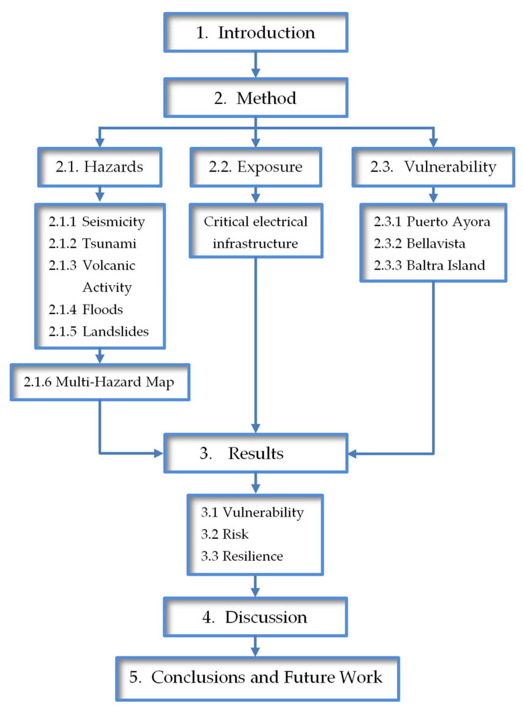
2. Methods
- Threat and vulnerability analysis, identifying and assessing natural threats specific to the region and their potential impact on energy infrastructure.
- The design of technical solutions and mitigation strategies.
- The development of infrastructure and technologies that can withstand extreme conditions, such as hybrid systems and energy storage.
- Strengthening institutional and community capacities. The training and preparation of the community and local authorities to manage and respond to emergencies.
- The implementation of appropriate policies and regulations. Proposals for policies that promote resilience and sustainability in developing energy infrastructure.
2.1. Hazards Analysis
2.1.1. Seismicity
2.1.2. Tsunami
2.1.3. Volcanic Activity (Ash)
2.1.4. Floods
2.1.5. Landslides
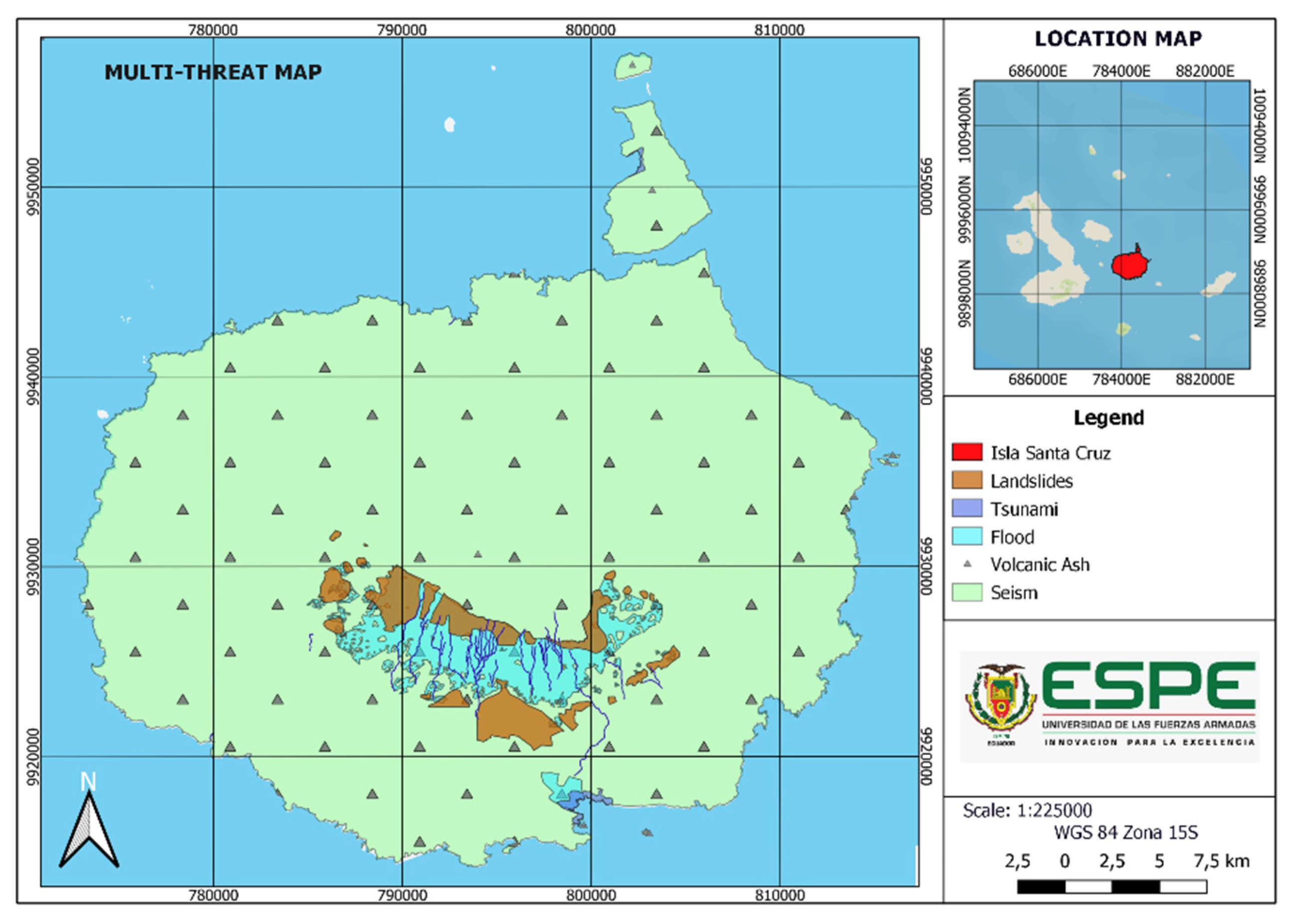
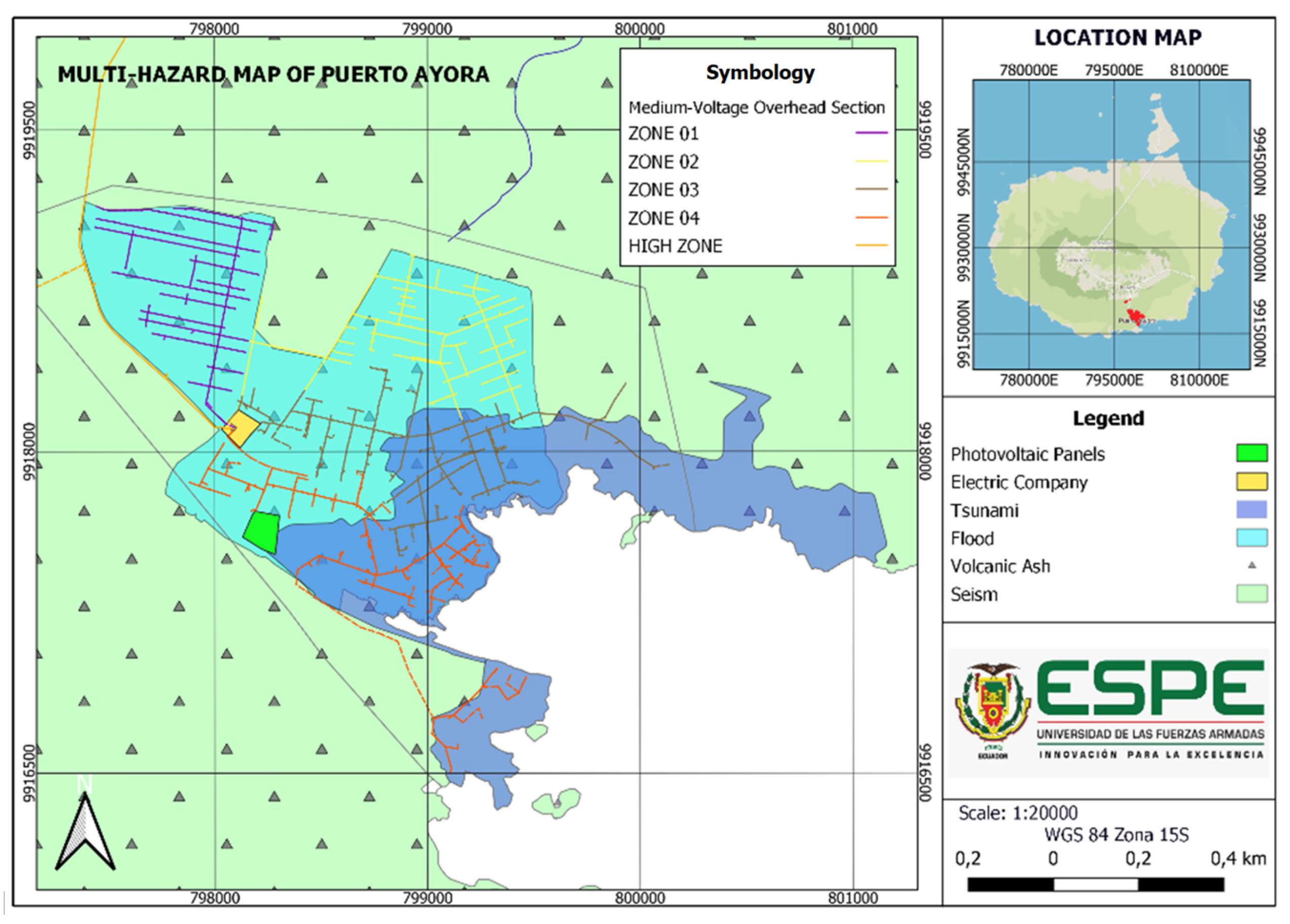
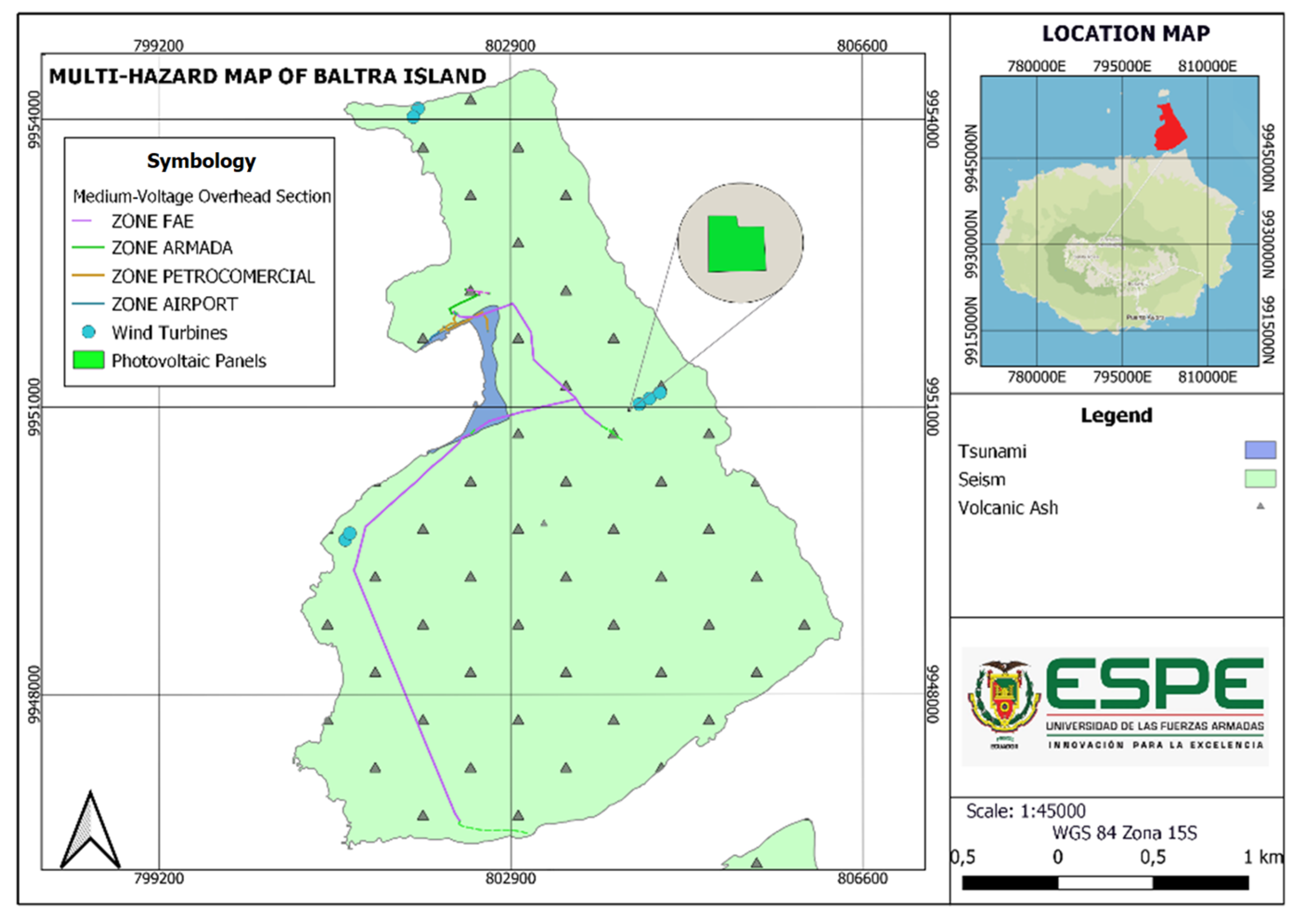
2.1.6. Multi-Hazard Map
2.2. Exposure Analysis
2.3. Vulnerability Analysis
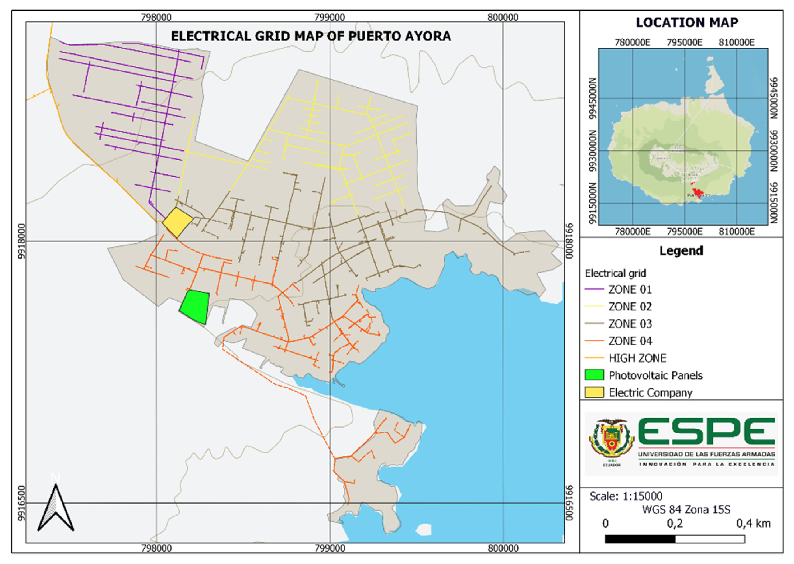
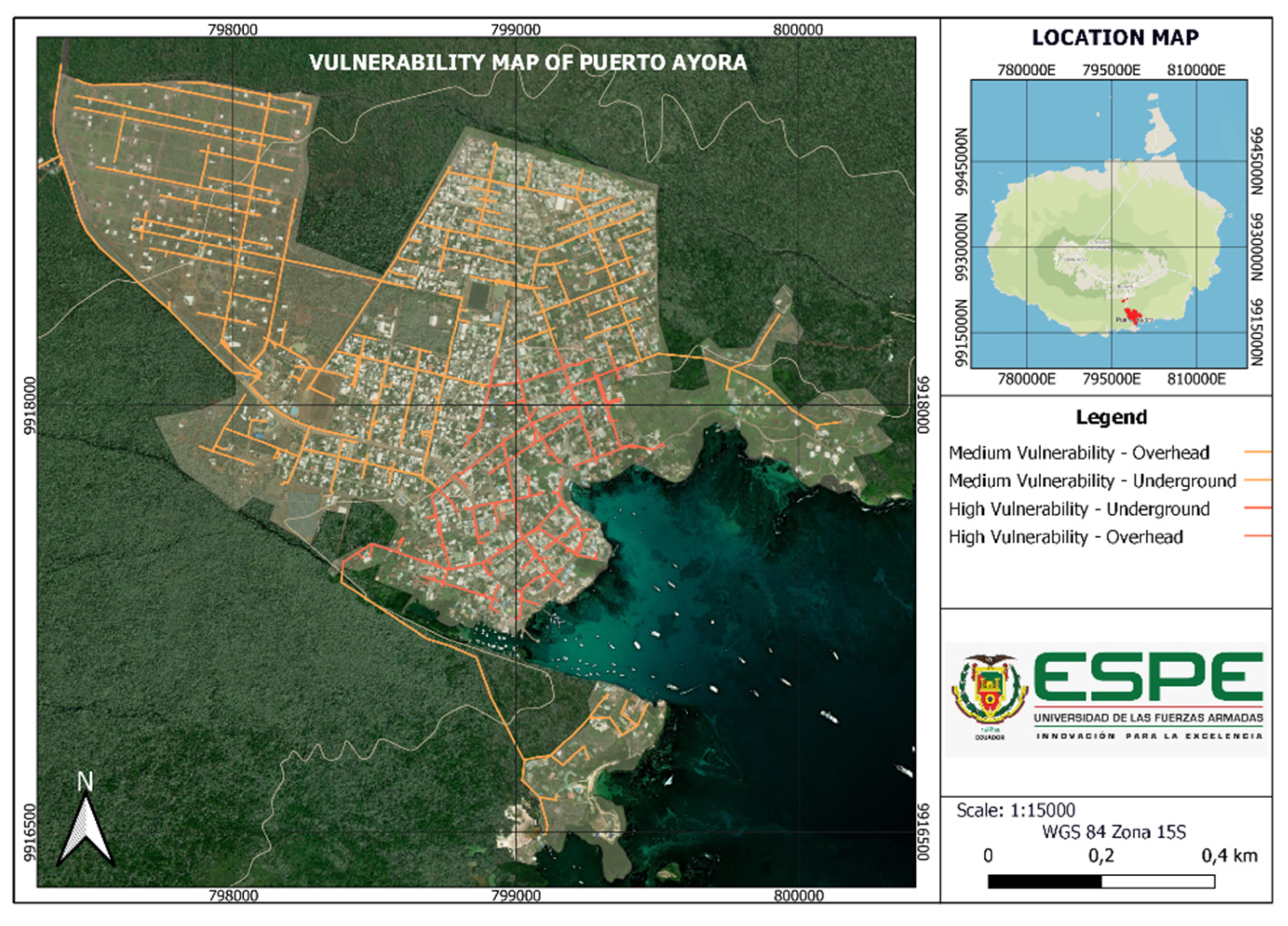
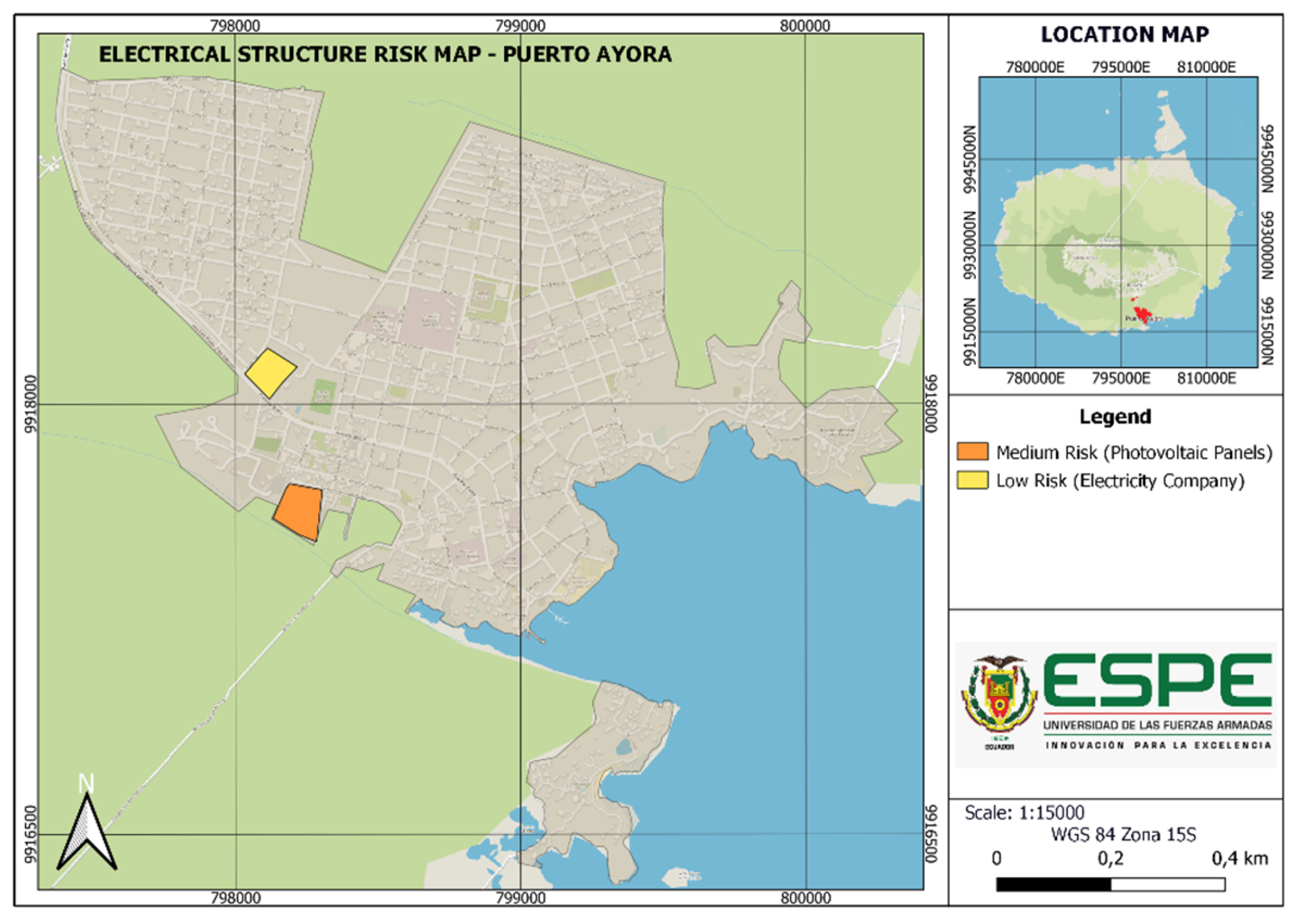
2.3.1. Vulnerability of Puerto Ayora
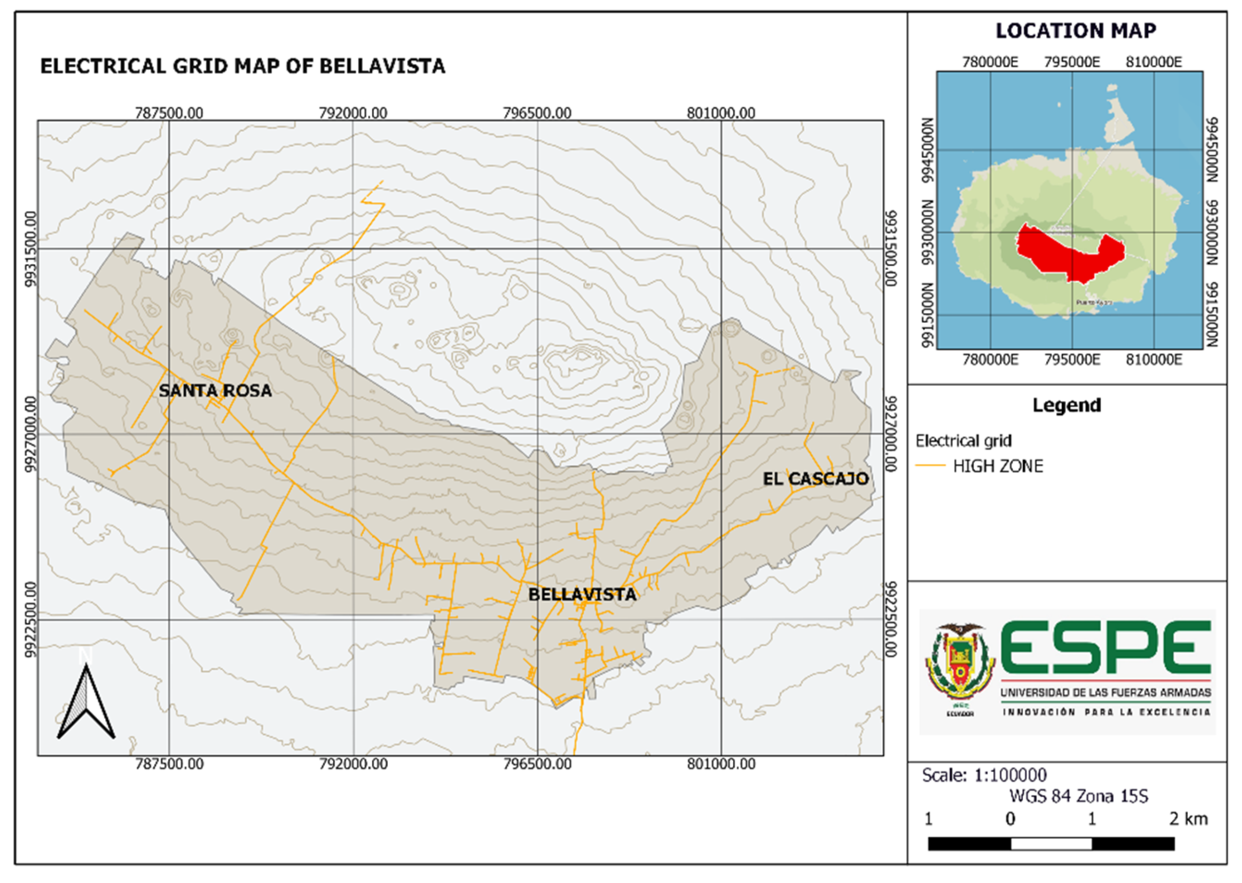
2.3.2. Vulnerability of Bellavista
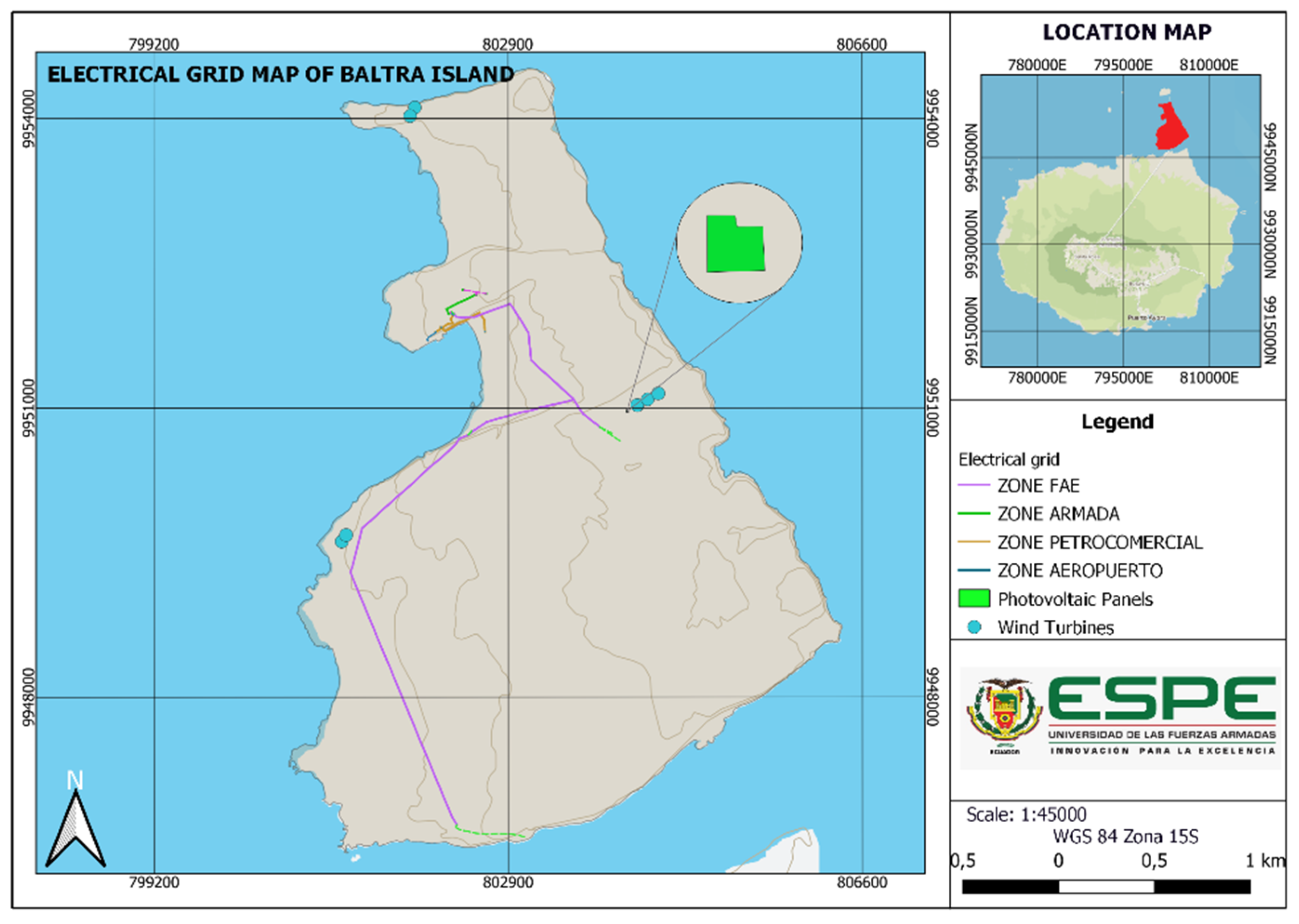
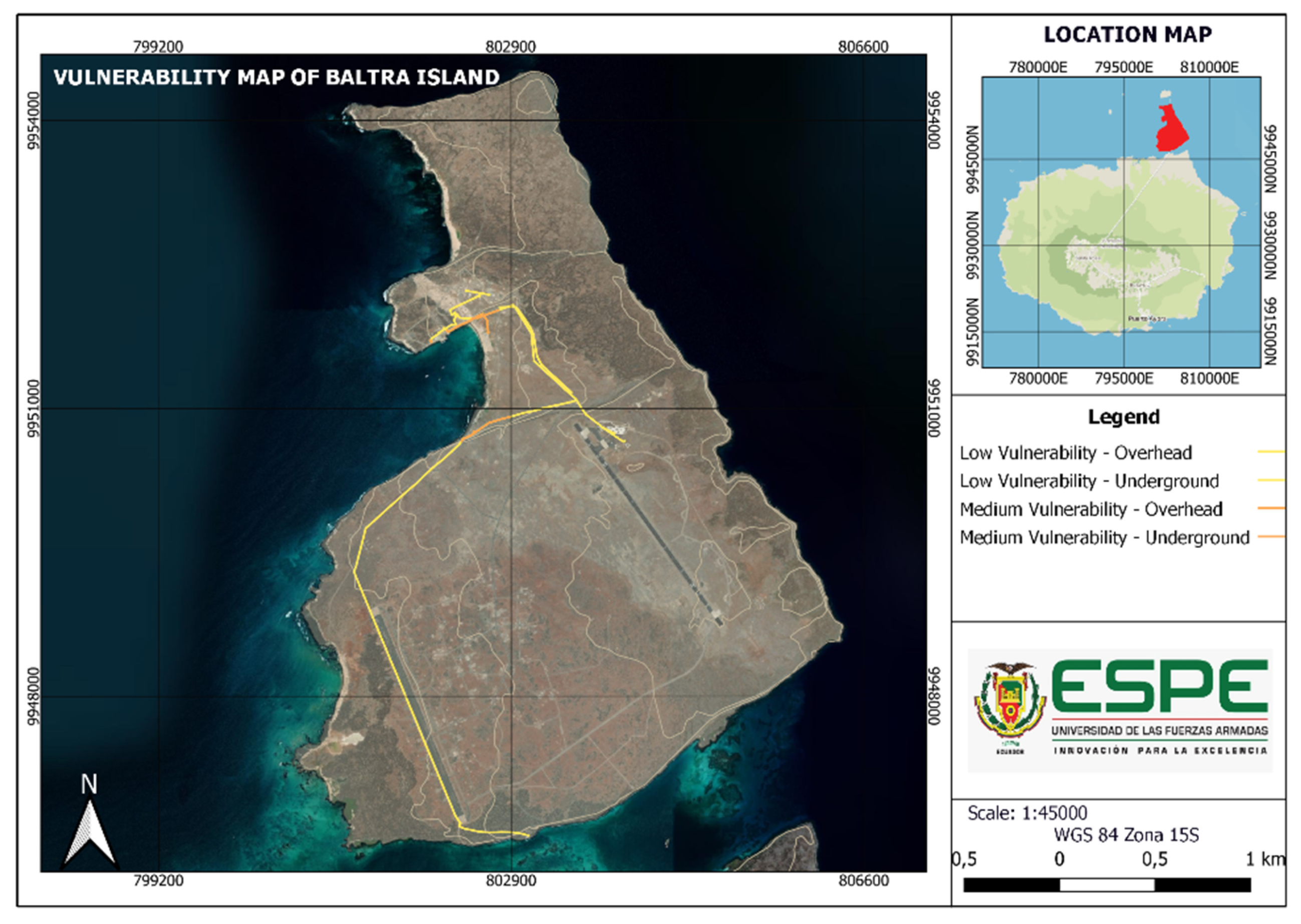
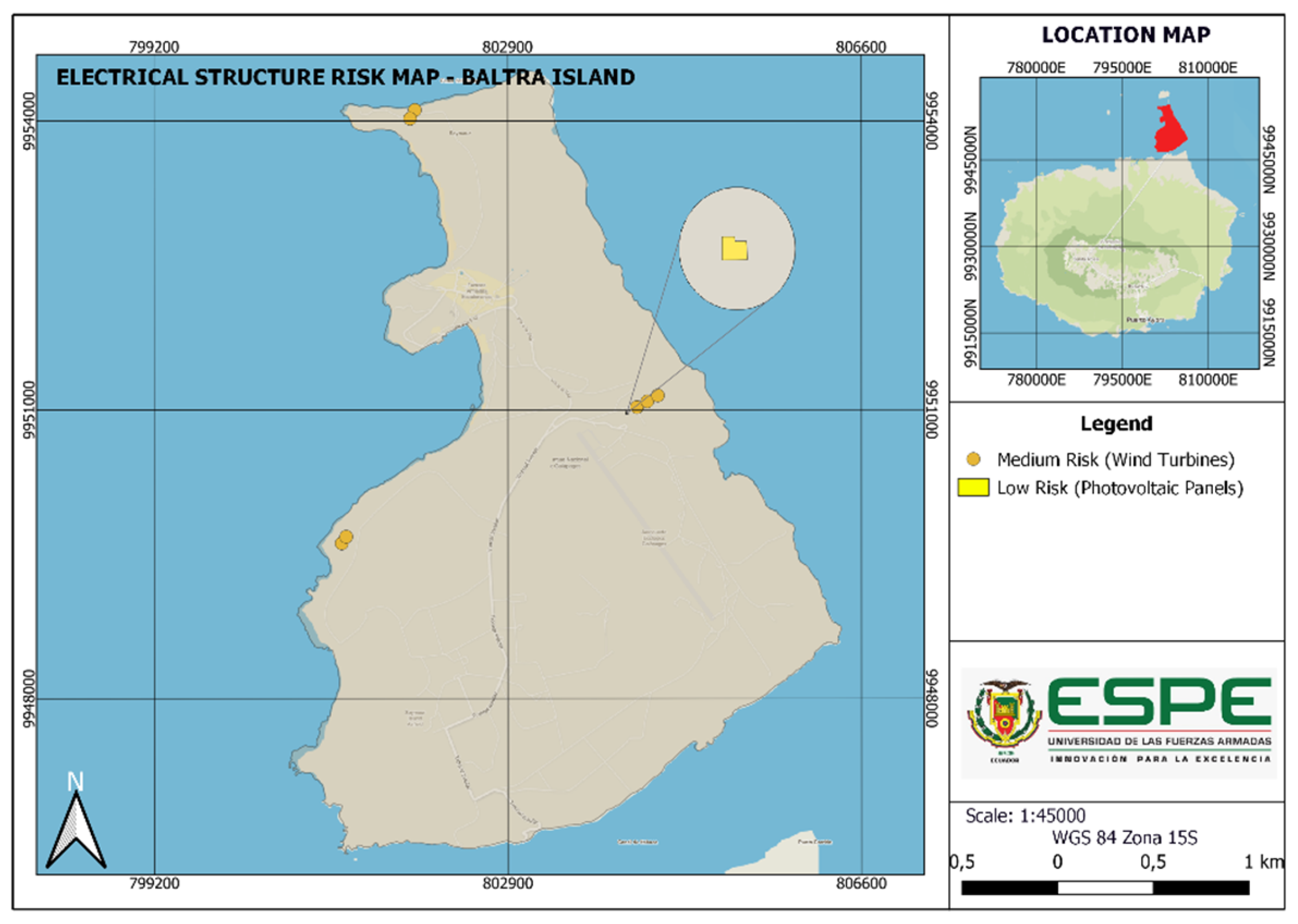
2.3.3. Vulnerability of Baltra Island
3. Results
3.1. Vulnerability
3.1.1. Puerto Ayora
3.1.2. Bellavista
3.1.3. Baltra Island
3.2. Risk Assessment
3.2.1. Risk Analysis by Areas
3.2.2. Risk Analysis for the Power System
3.3. Strategies for Fostering Resilience
3.3.1. Placement of Natural Mangroves for Energy and Debris Dissipation in Case of Tsunamis
3.3.2. Implementation of Underground Power Grids
3.3.3. Strengthening the Earthquake-Resistant Structure of Energy Distribution
3.3.4. Immediate Cleaning Plan for Photovoltaic Panels in Case of Volcanic Ash Fall
3.3.5. Battery Power Reserve
3.3.6. Upgrading the Sewer System
3.3.7. Retaining Walls Against Landslides
3.3.8. Implementation of Slopes
3.3.9. Surface Drains in Ravines
3.3.10. Risk Control Matrix
4. Discussion
5. Conclusions
Author Contributions
Funding
Institutional Review Board Statement
Informed Consent Statement
Data Availability Statement
Acknowledgments
Conflicts of Interest
References
- López-Saavedra, M.; Martí, J. Reviewing the multi-hazard concept. Application to volcanic islands. Earth-Sci. Rev. 2023, 236, 104286. [Google Scholar] [CrossRef]
- Taramelli, A.; Valentini, E.; Sterlacchini, S. A GIS-based approach for hurricane hazard and vulnerability assessment in the Cayman Islands. Ocean Coast. Manag. 2015, 108, 116–130. [Google Scholar] [CrossRef]
- Varo, J.; Sekac, T.; Jana, S.K.; Pal, I. GIS perspective hazard risk assessment: A study of Fiji Island. In Disaster Resilience and Sustainability; Elsevier: Amsterdam, The Netherlands, 2021; Chapter 9; pp. 197–238. [Google Scholar] [CrossRef]
- Ayala-Pico, J.; Arcos–Aviles, D.; Ibarra, A.; Fernandez, C.; Guinjoan, F.; Martinez, W. Current development of electricity generation systems in the Galapagos Islands—Ecuador. Renew. Energy Focus 2023, 46, 88–102. [Google Scholar] [CrossRef]
- The University of North Carolina at Chapel Hill. Center for Galapagos Studies. Available online: https://galapagos.unc.edu/ (accessed on 15 September 2024).
- Gobierno Autónomo Descentralizado Municipal de Santa Cruz (GADMSC). Bienvenidos a Santa Cruz. Available online: https://turismo.gadsantacruz.gob.ec/ (accessed on 5 August 2024).
- Independent National Electoral Commission (INEC). Censo de Población y Vivienda-Galápagos. Available online: https://www.ecuadorencifras.gob.ec/censo-de-poblacion-y-vivienda-galapagos/ (accessed on 24 June 2024).
- Gobierno Autónomo Descentralizado Municipal de Santa Cruz. Plan de Desarrollo y Ordenamiento Territorial 2021–2023; Gobierno Autónomo Descentralizado Municipal de Santa Cruz: Santa Cruz, Ecuador, 2021.
- Galapagos Conservation Trust. DG Zona de Profesor—Free Education Resources from the Galapagos Conservation Trust. Available online: https://zpdescubriendogalapagos.org/#geograf%C3%ADa (accessed on 17 June 2024).
- Haro-Baez, A.G.; Chavez, D.; Camino, C.; Arcos-Aviles, D. Seismic and Tsunami Risk Analysis for Installing Resilient Power Systems Based on Isolated Microgrids on Buildings: The Case of Puerto Ayora in Santa Cruz Island, Galapagos. Sustainability 2023, 15, 13769. [Google Scholar] [CrossRef]
- Imbaquingo, G.B.; Serrano, F.; Vásquez, R. Analisis de las amenazas naturales y el grado de preparación de población en la Isla Santa Cruz, Galápagos. Rev. Cienc. Segur. Def. 2019, 7, 75–106. [Google Scholar]
- Gobierno Autónomo Descentralizado Municipal del Cantón Santa Cruz. Agenda de Reducción de Riesgos del Cantón; Gobierno Autónomo Descentralizado Municipal de Santa Cruz: Santa Cruz, Ecuador, 2020.
- Proyecto de Riesgos Naturales del Departamento de Desarrollo Regional y Medio Ambiente and USAID. Desastres, Planificación y Desarrollo: Manejo de Amenazas Naturales para Reducir los Daños. Available online: http://www.oas.org/usde/publications/Unit/oea57s/begin.htm (accessed on 5 August 2024).
- Oyedepo, S.O. Energy and sustainable development in Nigeria: The way forward. Energy Sustain. Soc. 2012, 2, 15. [Google Scholar] [CrossRef]
- Clark, G.L.; Feldman, M.P.; Gertler, M.S.; Wójcik, D. (Eds.) The New Oxford Handbook of Economic Geography; Oxford Handbooks; Oxford University Press: Oxford, UK, 2018. [Google Scholar] [CrossRef]
- International Renewable Energy Agency (IRENA). Renewable Energy Opportunities for Island Tourism. Available online: https://www.irena.org/-/media/Files/IRENA/Agency/Publication/2014/IRENA_RE_Island_Tourism_report_2014.pdf (accessed on 20 June 2024).
- Zio, E. Challenges in the vulnerability and risk analysis of critical infrastructures. Reliab. Eng. Syst. Saf. 2016, 152, 137–150. [Google Scholar] [CrossRef]
- Schweikert, A.E.; Deinert, M.R. Vulnerability and resilience of power systems infrastructure to natural hazards and climate change. WIREs Clim. Chang. 2021, 12, e724. [Google Scholar] [CrossRef]
- Xu, L.; Feng, K.; Lin, N.; Perera, A.; Poor, H.V.; Xie, L.; Ji, C.; Sun, X.A.; Guo, Q.; O’alley, M. Resilience of renewable power systems under climate risks. Nat. Rev. Electr. Eng. 2024, 1, 53–66. [Google Scholar] [CrossRef]
- Espinoza, S.; Poulos, A.; Rudnick, H.; de la Llera, J.C.; Panteli, M.; Mancarella, P. Risk and Resilience Assessment with Component Criticality Ranking of Electric Power Systems Subject to Earthquakes. IEEE Syst. J. 2020, 14, 2837–2848. [Google Scholar] [CrossRef]
- ELECGALAPAGOS S.A. Empresa Eléctrica de Galápagos. Available online: https://www.elecgalapagos.com.ec/ (accessed on 16 June 2024).
- Eras-Almeida, A.A.; Egido-Aguilera, M.A.; Blechinger, P.; Berendes, S.; Caamaño, E.; García-Alcalde, E. Decarbonizing the Galapagos Islands: Techno-economic perspectives for the hybrid renewable mini-grid Baltra-Santa Cruz. Sustainability 2020, 12, 2282. [Google Scholar] [CrossRef]
- International Energy Agency. Renewable Energy Market Update—Outlook for 2023 and 2024. Available online: https://iea.blob.core.windows.net/assets/63c14514-6833-4cd8-ac53-f9918c2e4cd9/RenewableEnergyMarketUpdate_June2023.pdf (accessed on 24 June 2024).
- Keith, S.; David, P. Environmental Hazards Assessing Risk and Reducing Disaster; Taylor and Francis Group: Abingdon, UK, 2009. [Google Scholar]
- Rehak, D.; Slivkova, S.; Janeckova, H.; Stuberova, D.; Hromada, M. Strengthening Resilience in the Energy Critical Infrastructure: Methodological Overview. Energies 2022, 15, 5276. [Google Scholar] [CrossRef]
- Frydrychowicz-Jastrzębska, G. El Hierro Renewable Energy Hybrid System: A Tough Compromise. Energies 2018, 11, 2812. [Google Scholar] [CrossRef]
- ISO 31000:2018; Risk Management—Guidelines. International Organization for Standardization (ISO): Geneva, Switzerland, 2018.
- United Nations Office for Disaster Risk Reduction. Report of the Open-Ended Intergovernmental Expert Working Group on Indicators and Terminology Relating to Disaster Risk Reduction. Available online: https://www.undrr.org/publication/report-open-ended-intergovernmental-expert-working-group-indicators-and-terminology (accessed on 7 August 2024).
- The Intergovernmental Panel on Climate Change. AR5 Synthesis Report: Climate Change 2014. Available online: https://www.ipcc.ch/report/ar5/syr/ (accessed on 7 August 2024).
- D’Ercole, R. Seminario Nacional DIPECHO: Elementos de Reflexion: 1. Amenazas de Origen Natural y Antrópica, Vulnerabilidades y Riesgo en el Ecuador: 2. Respuestas a los Problemas Relacionados con las Amenazas, la Vulnerabilidad y los Riesgos en Ecuador y Mapas de Capacidades: 3. Necesidades y Prioridades para la Reducción de los Riesgos en el Ecuador (Segun las Entrevistas Realizadas en Marzo-Abril 2005 a Instituciones Nacionales e Internacionales Involucradas en el Campo de la Gestion De riesgos). Available online: https://www.documentation.ird.fr/hor/fdi:010048666 (accessed on 27 July 2024).
- Norma Ecuatoriana De La Construcción (NEC). Peligro Sísmico Diseño Sismo Resistente; MIDUVI—Ministerio de Desarrollo Urbano y Vivienda: Quito, Ecuador, 2015. [Google Scholar]
- USAGov. U.S. Geological Survey (USGS). Available online: https://www.usa.gov/es/agencias/servicio-geologico-de-estados-unidos (accessed on 8 August 2024).
- Chávez, D. Análisis de Riesgo de la Infraestructura en Puerto Ayora (Galápagos) ante Amenazas Naturales, Sismo y Tsunami, para una Posible Instalación Técnica de Paneles Fotovoltaicos; Universidad de las Fuerzas Armadas ESPE: Sangolquí, Ecuador, 2023. [Google Scholar]
- Willington, R.; Patrick, L.; Robert, W.; De La, G. Torre Informe de la investigación de campo de los efectos del tsunami de Japón marzo 2011, en las islas Galápagos. Acta Ocean. Del Pacífico 2012, 17, 177–203. [Google Scholar]
- Ceruti Maria, C. Volcanes de las islas Galápagos: Una mirada a su dimension simbolica. Scr. Ethnol. 2021, 43, 75–90. [Google Scholar]
- Instituto Nacional de Meteorología e Hidrología (INAMHI). Instituto Nacional de Metrología e Hidrología. Available online: https://www.inamhi.gob.ec/ (accessed on 7 August 2024).
- Fundación Charles Darwin. Datos Climatológicos Puerto Ayora. Available online: https://datazone.darwinfoundation.org/es/clima/puerto-ayora (accessed on 16 June 2024).
- Gray and Sotir. Movimientos en Masa. Available online: https://ecoambientes.tripod.com/id9.html (accessed on 18 June 2024).
- Secretaría Nacional de Gestión de Riesgos. Biblioteca n.d. Available online: https://www.gestionderiesgos.gob.ec/biblioteca/ (accessed on 25 November 2024).
- ELECGALAPAGOS Geoportal. Red Provincial Galapagos 2024. Available online: https://gis.elecgalapagos.com.ec/visor/ (accessed on 14 June 2024).
- Miyamoto International. Earthquake Engineering Technical Paper Archives. Available online: https://www.earthquakeengineeringtechnicalpapers.com/ (accessed on 29 June 2024).
- CIER Galápagos. Inauguración Proyecto Eólico Baltra y Parque Fotovoltaico Puerto Ayora—CIER Galápagos. Available online: https://ciergalapagos.wordpress.com/2016/08/04/inauguracion-proyecto-eolico-baltra-y-parque-fotovoltaico-puerto-ayora/ (accessed on 21 August 2024).
- Vega Franklin. Lo que el Viento se Llevó en Galápagos: USD 12 Millones en 3 Turbinas Eólicas. Available online: https://en.bitacoraec.com/ (accessed on 22 August 2024).
- Moity, N.; Delgado, B.; Salinas-De-León, P. Mangroves in the Galapagos islands: Distribution and dynamics. PLoS ONE 2019, 14, e0209313. [Google Scholar] [CrossRef]
- Alongi, D.M. Mangrove forests: Resilience, protection from tsunamis, and responses to global climate change. Estuar. Coast. Shelf Sci. 2008, 76, 1–13. [Google Scholar] [CrossRef]
- The University of Auckland. Cyclone Gabrielle: Outages Strengthen the Case for Burying Power Lines. Available online: https://www.auckland.ac.nz/en/news/2023/02/22/the-case-for-burying-power-lines.html (accessed on 8 August 2024).
- Olivares, Z.; Ignacio, C. Planificación de Sistemas Eléctricos Frente a Terremotos: Beneficios del Almacenamiento de Energía en la Resiliencia del Sistema; Universidad de Chile: Santiago, Chile, 2019. [Google Scholar]
- Zorn, E.; Walter, T.R. Influence of volcanic tephra on photovoltaic (PV)-modules: An experimental study with application to the 2010 Eyjafjallajökull eruption, Iceland. J. Appl. Volcanol. 2016, 5, 2. [Google Scholar] [CrossRef]
- Wheeler, N.; Candidate, J.D. Fire, Wind, and Waves: Grid Resilience Threats and Opportunities in California and New York Acknowledgements; UC Berkeley School of Law: Berkeley, CA, USA, 2020. [Google Scholar]
- Schlumberger, J.; Ferrarin, C.; Jonkman, S.N.; Loaiza, M.A.D.; Antonini, A.; Fatorić, S. Developing a framework for the assessment of current and future flood risk in Venice, Italy. Nat. Hazards Earth Syst. Sci. 2022, 22, 2381–2400. [Google Scholar] [CrossRef]
- Fontanese, M.M. A Stability Analysis of the Retaining Walls of Machu Picchu. Master’s Thesis, University of Pittsburgh, Pittsburgh, PA, USA, 2007. [Google Scholar]
- Choi, K.; Cheung, R.W. Landslide disaster prevention and mitigation through works in Hong Kong. J. Rock Mech. Geotech. Eng. 2013, 5, 354–365. [Google Scholar] [CrossRef]
- Cely-Calixto, N.J. Propuesta de un sistema urbano de drenaje sostenible para reducir los niveles de inundación en la ciudad de Cúcuta, Colombia. Eco Matemático 2022, 13, 6–17. [Google Scholar] [CrossRef]


| Hazard | “The potential occurrence of a natural or human-induced physical event that may cause loss of life, injury, or […] damage and loss to property, infrastructure, livelihoods, service provision and environmental resources”. |
| Exposure | “The presence of people; livelihoods; environmental services and resources; infrastructure; or […] assets in places and settings that could be adversely affected”. |
| Vulnerability | “The propensity or predisposition to be adversely affected”. |
| Risk | “The potential for consequences where something of value is at stake and the outcome is uncertain, […]”. |
| Seismic Zone | I | II | III | IV | V | VI |
|---|---|---|---|---|---|---|
| Z factor | 0.15 | 0.25 | 0.30 | 0.35 | 0.40 | ≥0.50 |
| Seismic hazard characterization | Intermediate | High | High | High | High | Very High |
| Ord. | Date | Latitude | Length | Depth | M.A.G. |
|---|---|---|---|---|---|
| 1 | 6/4/1954 | −0.88 | −91.864 | 15 | 6.26 |
| 2 | 5/5/1926 | 2.893 | −91.384 | 10 | 5.88 |
| 3 | 11/8/1929 | 2.414 | −88.733 | 10 | 5.75 |
| 4 | 22/12/1999 | −0.625 | −91.882 | 10 | 5.7 |
| 5 | 20/10/1987 | 0.917 | −87.073 | 10 | 5.6 |
| 6 | 10/9/1991 | 0.904 | −87.389 | 10 | 5.4 |
| 7 | 27/7/1991 | 1.773 | −90.49 | 10 | 5.4 |
| Number of Hazards | Category |
|---|---|
| 1 | Very low |
| 2 | Low |
| 3 | Medium |
| 4 | High |
| 5 | Very high |
| Puerto Ayora | |||||||
|---|---|---|---|---|---|---|---|
| Sector | Hazards | Total | Category | ||||
| Landslide | Flood | Volcanic Ash | Tsunami | Earthquake | |||
| Zone 1 | 0 | 1 | 1 | 0 | 1 | 3 | Medium |
| Zone 2 | 0 | 1 | 1 | 0 | 1 | 3 | Medium |
| Zone 3 | 0 | 1 | 1 | 1 | 1 | 4 | High |
| Bellavista | |||||||
|---|---|---|---|---|---|---|---|
| Sector | Hazards | Total | Category | ||||
| Landslide | Flood | Volcanic Ash | Tsunami | Earthquake | |||
| Santa Rosa | 1 | 1 | 1 | 0 | 1 | 4 | High |
| Bellavista | 1 | 1 | 1 | 0 | 1 | 4 | High |
| El Cascajo | 0 | 0 | 1 | 0 | 1 | 2 | Low |
| Baltra Island | |||||||
|---|---|---|---|---|---|---|---|
| Sector | Hazards | Total | Category | ||||
| Landslide | Flood | Volcanic Ash | Tsunami | Earthquake | |||
| Port Seymour | 0 | 0 | 1 | 1 | 1 | 3 | Medium |
| Remaining area | 0 | 0 | 1 | 0 | 1 | 2 | Low |
| Risk | Percentage |
|---|---|
| Low | 1–33% |
| Medium | 34–66% |
| High | 67–100% |
| Risk Analysis | ||||
|---|---|---|---|---|
| Area | Parameters | Category | ||
| Exposure to Threats | Vulnerability | Risk Reduction Measures | ||
| Puerto Ayora | 3–4 | Medium–High | SAT Early Warning System Tsunami evacuation routes Annual tsunami emergency drill Land use and occupation plans | Medium |
| Bellavista | 2–4 | Low–High | SAT Early Warning System Land use and occupation plans | Medium |
| Baltra Island | 2–3 | Low–Medium | SAT Early Warning System Tsunami evacuation routes Energy storage in batteries | Low |
| Structure | Area | Hazards | Construction Materials | Year of Construction |
|---|---|---|---|---|
| ELEC Galapagos | Being in an urban area and close to the fire station, a low value was considered. | It is located where floods, earthquakes, and ash fall have an effect. | Its construction is based on reinforced concrete. | Year of construction: 1998 [21] |
| Photovoltaic plant (Puerto Ayora) | Likewise, it is located in an urban area but further away from the fire department. | It is located where floods, earthquakes, ash falls, and tsunamis have an effect. | Solar panels are mainly made of silicon, an essential semiconductor metal that generates energy. They also contain other materials, such as aluminum and copper, which are highly corrosion-resistant. Finally, they are made up of glass sheets. These considerations have placed them in the range of steel materials. | Year of construction: 2014 [42] |
| Photovoltaic plant (Baltra Island) | It is close to the Baltra airport, considered a safe and early response area. | It is located where only earthquakes and ash fall would have an effect. | ||
| Wind towers (Baltra Island) | Certain wind towers are located in different island areas and are far from response entities. | They are located where only earthquakes and ash fall would have an effect. | Their composition is mainly made up of high-quality steel, and their shafts are made of light and resistant materials such as fiberglass, carbon fiber, or polyester. | Year of construction: 2006 [43] |
| Electrical network poles | As their locations are in both urban and rural areas, specific poles will not have immediate disaster recovery. | They are generally affected by landslides, earthquakes, ash falls, and, in certain places, tsunamis, which is why they are valued highly considering their exposure. | The posts are made of a wide variety of materials, including wooden and metal posts generally located near the sea and others made of concrete in the populated areas. | Intermediate values were taken since old and new poles have no specific construction year. |
| Power transformers | The transformers are mainly located close to the electric company, so they have a partially immediate recovery in the event of disasters. | Like the poles, they would be affected by landslides, earthquakes, and ash fall. | Transformers are mainly made of steel and other metal components. | Like the poles, there is no specific year of construction, but there is constant maintenance, which is considered a below-average value. |
| Structure | Zone | Hazards | Construction Materials | Year of Construction | TR | %R |
|---|---|---|---|---|---|---|
| ELEC Galapagos | 0.1 | 0.5 | 0.2 | 0.5 | 1.3 | 32.5% |
| Photovoltaic plant (Puerto Ayora) | 0.2 | 0.8 | 0.4 | 0.2 | 1.6 | 40.0% |
| Photovoltaic plant (Baltra Island) | 0.2 | 0.3 | 0.4 | 0.2 | 1.1 | 27.5% |
| Wind towers (Baltra Island) | 0.5 | 0.4 | 0.4 | 0.3 | 1.6 | 40.0% |
| Electrical network poles | 0.5 | 0.8 | 0.5 | 0.5 | 2.3 | 57.5% |
| Power transformers | 0.3 | 0.5 | 0.4 | 0.3 | 1.5 | 37.5% |
| Type | Category | Resilience-Based Solutions |
|---|---|---|
| Earthquake | Medium | Energy reserve in batteries Reinforcement of the earthquake-resistant structure of energy distribution |
| Tsunami | High | Placement of natural mangroves to dissipate energy and debris in cases of tsunamis Implementation of underground electrical networks |
| Ash fall | Medium | Immediate cleaning plan for photovoltaic panels Energy reserve in batteries |
| Flood | Low | Improvement of the sewage system |
| Type | Category | Resilience-Based Solutions |
|---|---|---|
| Earthquake | Medium | Energy reserve in batteries Reinforcement of the earthquake-resistant structure of energy distribution |
| Ash fall | Medium | Immediate cleaning plan for photovoltaic panels Energy reserve in batteries |
| Flood | Medium | Improvement of the sewage system Surface drains in ravines |
| Landslide | Medium | Implementation of slopes Retaining walls against landslides |
| Type | Category | Resilience-Based Solutions |
|---|---|---|
| Earthquake | Medium | Energy reserve in batteries Reinforcement of the earthquake-resistant structure of energy distribution |
| Tsunami | High | Placement of natural mangroves to dissipate energy and debris in cases of tsunamis Implementation of underground electrical networks |
| Ash fall | Medium | Immediate cleaning plan for photovoltaic panels Energy reserve in batteries |
Disclaimer/Publisher’s Note: The statements, opinions and data contained in all publications are solely those of the individual author(s) and contributor(s) and not of MDPI and/or the editor(s). MDPI and/or the editor(s) disclaim responsibility for any injury to people or property resulting from any ideas, methods, instructions or products referred to in the content. |
© 2024 by the authors. Licensee MDPI, Basel, Switzerland. This article is an open access article distributed under the terms and conditions of the Creative Commons Attribution (CC BY) license (https://creativecommons.org/licenses/by/4.0/).
Share and Cite
Haro-Baez, A.G.; Posso, E.; Rojas, S.; Arcos-Aviles, D. Simplified Multi-Hazard Assessment to Foster Resilience for Sustainable Energy Infrastructure on Santa Cruz Island, Galapagos. Sustainability 2025, 17, 106. https://doi.org/10.3390/su17010106
Haro-Baez AG, Posso E, Rojas S, Arcos-Aviles D. Simplified Multi-Hazard Assessment to Foster Resilience for Sustainable Energy Infrastructure on Santa Cruz Island, Galapagos. Sustainability. 2025; 17(1):106. https://doi.org/10.3390/su17010106
Chicago/Turabian StyleHaro-Baez, Ana Gabriela, Eduardo Posso, Santiago Rojas, and Diego Arcos-Aviles. 2025. "Simplified Multi-Hazard Assessment to Foster Resilience for Sustainable Energy Infrastructure on Santa Cruz Island, Galapagos" Sustainability 17, no. 1: 106. https://doi.org/10.3390/su17010106
APA StyleHaro-Baez, A. G., Posso, E., Rojas, S., & Arcos-Aviles, D. (2025). Simplified Multi-Hazard Assessment to Foster Resilience for Sustainable Energy Infrastructure on Santa Cruz Island, Galapagos. Sustainability, 17(1), 106. https://doi.org/10.3390/su17010106