Review

A Critical Analysis of Geological Hazard Risk Assessment Including Future Perspectives

1
College of Geological Engineering and Geomatics, Chang’an University, Xi’an 710054, China
2
Key Laboratory of Western China’s Mineral Resources and Geological Engineering, Ministry of Education, Chang’an University, Xi’an 710054, China
3
Shandong Jiantou Engineering Inspecting & Appraisal Co., Ltd., Qingdao 266112, China
4
School of Water & Environmental, Chang’an University, Xi’an 710054, China
5
Anhui Urban Construction Design Institute Co., Ltd., Hefei 230051, China
6
Shanxi Engineering Survey Research Institute Co., Ltd., Xi’an 710054, China
*
Authors to whom correspondence should be addressed.
Sustainability 2024, 16(9), 3701; https://doi.org/10.3390/su16093701
Submission received: 2 April 2024 / Revised: 23 April 2024 / Accepted: 26 April 2024 / Published: 28 April 2024
(This article belongs to the Special Issue Geological Environment Monitoring and Early Warning Systems)

Abstract

:
Geological hazards are widely distributed, cause huge losses, and have always been the focus of attention for engineering and environmental geologists. Geological hazard evaluation is the basis of research and has important theoretical significance for preventing and controlling geological hazards. Therefore, geological hazard evaluation has become the focus of engineering and environmental geology. The question of how to build a universal index system model of geological hazard evaluation is an urgent problem that needs to be solved in geological hazard evaluation. Based on a large amount of previous research data, this paper takes landslide hazard as an example and systematically expounds the main problems that need to be solved in the current geological hazard evaluation from five aspects: basic concept, evaluation scope and accuracy, evaluation index system and evaluation criteria, evaluation method, and applicability of evaluation results. A landslide hazard assessment index system model is proposed, which applies to all regions, including all of the factors that may affect the formation of landslides. It is also hoped that this will be used as an example to establish various types of disaster evaluation and assessment systems. If the parameter has no value in the assessment process, it can be processed as 0. On this basis, further research is suggested from the perspectives of the geological hazard evaluation level, geological hazard evaluation theory, and method. To provide thoughts on and suggestions for geological hazard risk assessment method research, standard revision, investigation and evaluation, and risk management and control need to be considered.

1. Introduction

Geological hazards are combinations of geological events that damage human lives, property, and the natural environment. They are produced by the earth’s natural internal and external dynamic actions or by the human-induced environmental degradation [1].
The frequent occurrence of geological hazards has caused great harm to social and economic activities and human life [2,3]. With the development of society, the issue of environmental sustainability has attracted more and more attention [4,5]. The question of how to prevent and reduce the losses caused by geological hazards has become a primary issue. Therefore, geological hazard evaluation has become a necessary research topic.
Since the United Nations published natural disaster hazard assessment methods and put forward and completed the 10-year plan (IDNDR) to reduce losses caused by geological hazards by 30%, many research results on geological hazard evaluation have emerged [6]. These include the study of geological hazard control and regionalization [7], the study of geological hazard evaluation and evaluation methods, and the construction of a geological hazard information system [8]. However, this topic can generally be divided into geohazard susceptibility, risk, and hazard evaluation [9].
In the 1970s, numerous scholars extensively employed qualitative methods to carry out a susceptibility assessment of geological hazards [10]. However, with the emergence and development of GIS technology, the challenge of conducting a superimposed analysis of geological hazard susceptibility data has been overcome, leading to a shift towards utilizing mathematical models in conjunction with GIS tools as the mainstream approach for assessing geological hazard susceptibility [11,12]. A geological hazard risk assessment is distinct from a susceptibility assessment as it incorporates temporal considerations. Hence, it is often defined as evaluating the likelihood of potential destructive phenomena occurring within a specific timeframe in a study area [13]. Assessing geological disaster hazards involves evaluating potential risks to human life, property loss, and environmental damage based on risk results; thus, vulnerability is considered alongside risk assessment [14]. Nevertheless, scholars may have varying interpretations regarding the definitions related to geological hazard susceptibility, risk, and hazard, which will be elaborated upon in Section 2.1.
This paper analyzes the existing research results, and it focuses on landslide hazards, summarizes the existing problems in the current research, and presents a preliminary idea for future geological hazard evaluation research.

2. Problems in Current Geological Hazard Evaluation Research

Upon evaluating the geological hazard evaluation research findings, it becomes evident that while some progress has been made, there are also significant prevailing issues. This article will focus on five aspects.

2.1. Basic Concept

Since the beginning of geological hazard research, problems have existed, such as the ambiguity of basic concepts and the lack of unified definitions. The connotation and extension of the concepts of geological hazards and hidden dangers of geological hazards are not clear enough. Different scholars have different understandings of these concepts. The content and boundaries of geological hazard susceptibility, risk, and hazard assessment are unclear.
Zhang [15] considered generalized geological hazards to occur due to geological (natural, artificial, or integrated) mutations of the geological environment or progressive damage and loss caused by the phenomenon of human life and property or events. Geological hazards, in a narrow sense, refer to hazards related to geological action that are caused by natural factors or human activities and endanger the safety of lives and property, including rock falls, landslides, mudslides, ground subsidence, ground collapses, ground fissures, etc. [16]. Zhang et al. [9] believe that a geological hazard is a process or phenomenon in which an inevitable geological process deteriorates the geological natural environment, destroying human life and property or seriously destroying the resources and environment that humans rely on for survival and development. A geological event destroys human life, property, and living environments. In the world, geological hazards mainly refer to collapses, landslides, and debris flows, broadly equivalent to landslides [17].
The definition of a geological hazard susceptibility assessment is relatively straightforward. Landslide susceptibility in international standards refers to the qualitative or quantitative evaluation of the type, volume (or area), and spatial distribution of existing or potential landslides in an area. Geological disaster-prone areas in China refer to regions that are prone to geological hazards. Existing and potential geological hazards should be considered in assessing susceptibility, but the time dimension should not be considered [18]. It mainly uses the principle of discussing the future with the present to analyze the situation of hazards in a specific area and predict the possibility of destructive geological hazards in the future [19]. The critical content of geological hazard susceptibility assessment is the distribution density, characteristics, and susceptibility conditions of geological hazards. Many scholars have conducted much work in this area and made some progress [20].
However, the definitions of a geological hazard risk and hazard assessment are very confusing. Some scholars believe that the risk assessment of geological hazards mainly refers to evaluating the possibility of potential destructive geological hazards in the study area over a period, which is a qualitative evaluation [20]. Other scholars believe that the risk assessment of geological hazards is a semi-quantitative assessment of the possibility of life casualties and property losses caused by geological hazards. As for the definition of hazard, different scholars have different understandings [20]. Varnes et al. [21] believe that the term hazard refers to the expected value of the number of deaths caused by a geological event at a certain period. Fell et al. [22] believe that hazard is the probability of a disaster causing losses to human life, property, and the environment. Huang and Xiang [23] believe that hazard refers to the likelihood of a disaster in the event of casualties and property losses. Zhu et al. [24] believe that geological hazards may cause the loss of life, property, and social economy within specific geographical and time ranges.
Due to the lack of clear basic concepts in the field of geological hazard assessment, the authors consulted many studies in the literature and proposed the following definitions:
Geological hazards refer to destructive geological phenomena that have occurred in the past and caused the loss of human lives and property. The core is that they have rendered human life casualties and property losses, meaning they are harmful.
Potential geological hazards refer to destructive geological phenomena that will likely undergo obvious deformation and damage within a specific evaluation period and threaten human engineering activities or human life and property. There are three situations as follows: ① existing harmful geological phenomena that may threaten human engineering activities or human life and property in the future; ② currently, they do not exist, but they can be expected to cause obvious deformation and damage in the future, which will affect human engineering activities or threaten human life and property, such as current unstable slopes that may develop into collapses or landslides in the future; and ③ bad geological phenomena that have occurred in the past and caused human life casualties and property losses (geological hazards referred to above), which may reactivate in the future and threaten human engineering activities or human life and property. There are two conditions that can determine whether adverse geological phenomena constitute hidden dangers of geological hazards. One is whether deformation and destruction will occur within a specific evaluation period, and the other is whether it will cause human life casualties and property losses after deformation and destruction. The two conditions are indispensable. Suppose deformation and destruction occur within a specific evaluation period but do not cause human life casualties and property losses. In that case, they are still classified as destructive geological phenomena.
According to the above concepts, the objects of geological hazard susceptibility evaluation are unfavorable geological phenomena and geological hazards, and the risk and hazard evaluation of geological hazards mainly target the hidden danger points of geological hazards. The assessment of geological hazard susceptibility is mature enough to allow for the use of the existing definition. Geological hazard susceptibility refers to an area that is prone to geological hazards. Adverse geological phenomena and hazards should be considered in evaluating susceptibility, but the time scale should not be considered [18]. The key content of a geological hazard susceptibility evaluation is the formation conditions and triggering factors of geological hazards. Existing adverse geological phenomena or the development status of geological hazards should not be used as indicators for evaluating the susceptibility of geological hazards but as essential bases for inspecting the results of assessing the susceptibility of geological hazards.
One object of a geological hazard risk assessment is a potential geological hazard, regardless of the time scale. One can refer to the “geological hazard risk assessment specifications” and mainly predict and evaluate the severity of the maximum human life casualties and property losses that potential geological hazards may cause. The core content predicts and evaluates potential geological hazards, including the maximum impact range, population, and total asset survey.
Another object of a geological hazard assessment may be the hidden danger point of a geological hazard, and the time scale must be considered to predict and evaluate a certain number of casualties and property losses caused by hidden danger points of geological hazards at different time scales. The core content includes the calculation of the probability of damage being caused by potential geological hazards at different time scales, predicting the impact range of geological hazards, and evaluating certain levels of casualties and property losses caused by geological hazards.

2.2. Evaluation Range and Accuracy

When analyzing the research results of a geological hazard evaluation, the scope of the assessment varies greatly, ranging from tens of square kilometers to hundreds of thousands of square kilometers [25].
Ji et al. [26] conducted a small regional geological hazard assessment in Hancheng, Shaanxi Province; Dou et al. [27] used the RF and DT models to evaluate the susceptibility of geological hazards in Izu-Oshima, Japan. The above are small-scale geological hazard assessment studies. The medium range mainly refers to the range above the county level, or the research focus. Wang and Yi [28] used AHP to divide Mianyang into high-prone areas, medium-prone areas, and low-prone areas for geological hazards; Peng et al. [29] used the information volume method to assess the susceptibility of geological hazards. Research on large-scale geological hazards mainly focuses on compiling geological hazard distribution maps above the provincial level. Aleotti and Chowdhury [30] compiled a 1:25,000 geological hazard risk zoning map using data on landslide events in Italy.
There is no mature prediction and evaluation standard for the region. Concerning the landslide hazard zoning guidelines proposed by the Australian Geomechanics Society [31], Wu et al. [20] initially proposed the application scope of the results of geological hazard zoning. According to the current progress of the national geological hazard survey, it is not appropriate to emphasize the survey distribution and susceptibility evaluation zoning map of the federal or provincial scale with a ratio of less than 1:200,000. Quality and accuracy are difficult to guarantee for such a small-scale national geological hazard risk and zoning map. The 1:50,000 scale survey and the primary- to intermediate-level dangerous zoning mapping are more suitable for land use, hazard prevention, and mitigation planning at the city and regional levels. In contrast, large-scale geological hazard surveys, reconnaissance, catalogs, and hazard and risk zoning mapping only apply to key towns and major national engineering sites.
Due to the significant difference in the scope of the evaluation, the scale of the drawing will inevitably be very different, and the accuracy of the assessment is naturally impossible to compare. Therefore, to solve the problem of an uneven evaluation accuracy, this paper recommends the method proposed by Wu [20]: the regional geological hazard evaluation should obtain the scale evaluation results of 1:200,000 and 1:50,000 as much as possible. Moreover, to solve the problem of incoherence between regions due to different scales or different evaluation methods, it is suggested that a higher administrative organ should organize the geological hazard evaluation study with the basin or geomorphic unit as the region.

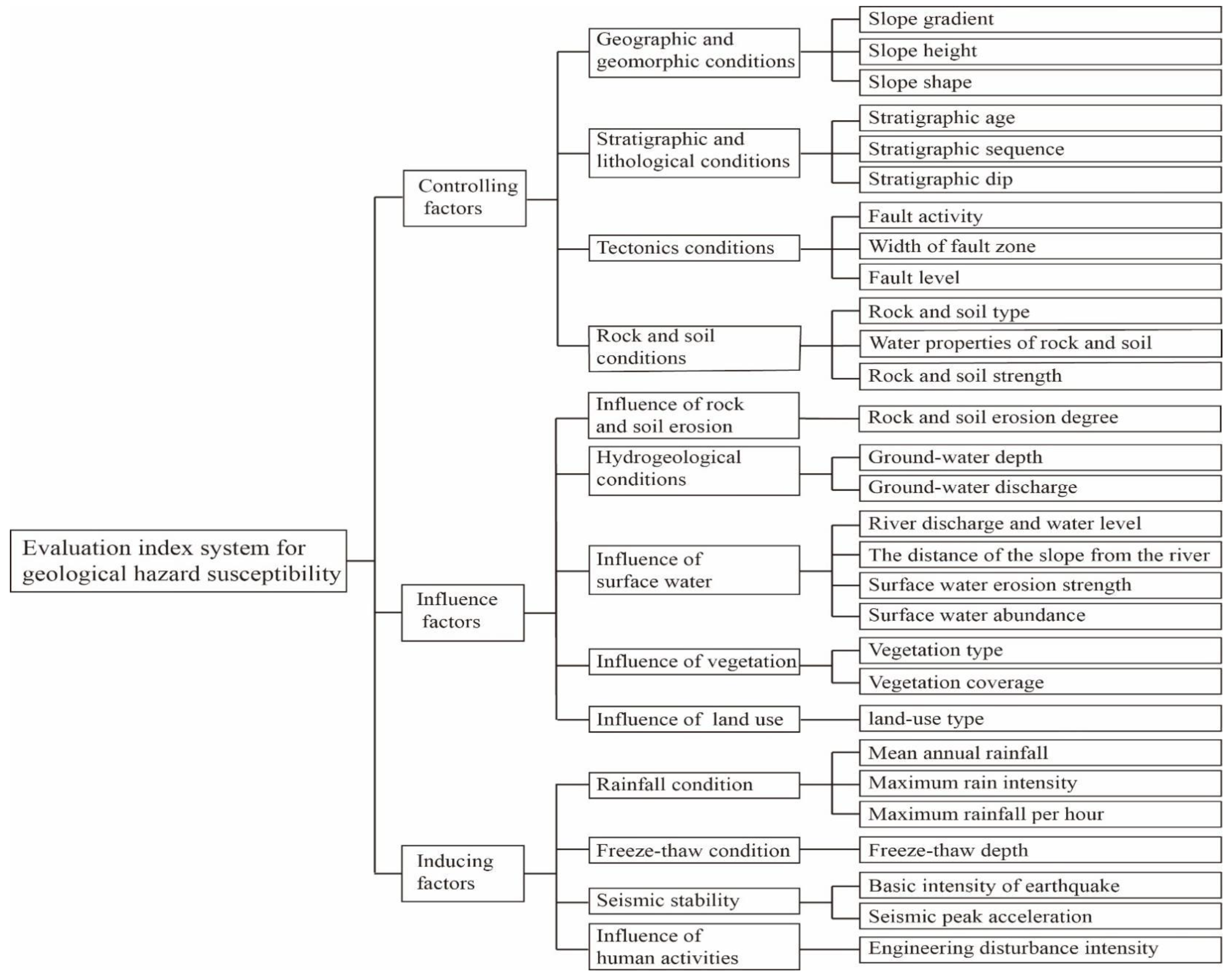
2.3. Evaluation Index System and Evaluation Criteria

There are many types of geological hazards. Geological hazards include two types, sudden and slow-change types, with eight sub-categories, for a total of thirty-four types.
Some scholars mainly conduct evaluation research on a certain kind of geological hazard; Zhou and Ning [32] discussed the existing problems of the single-channel debris flow risk assessment model in terms of parameter selection, unbalanced sample data, generalization ability, and spatial variability of the debris flow system. Chen and Li [33] compared and analyzed the performance of various combinations in landslide sensitivity modeling. Yi et al. [34] used the weight factor model to analyze and evaluate the risk of land subsidence. Fan et al. [35] monitored the land subsidence in the main urban area of Nanjing and revealed the spatial distribution characteristics of land subsidence in the study area.
However, most scholars use all of the geological hazards in the evaluation area to conduct evaluation research. For example, Wen et al. [36] used the AHP attribute identification model based on the GIS platform to assess geological hazards in the study area. Chen et al. [37] used the information volume model to investigate the susceptibility of the study area to geological hazards.
The geological conditions and triggering factors of each geological disaster are different, and the forms of damage to the hazard-bearing body are also entirely different. For example, landslide disasters often damage the structures of landslides in the form of overall damage with the disintegration of landslides. The sliding body destroys the bearing body at the front edge of the landslide. The destruction of the disaster-bearing body by the debris flow includes submergence, overflow, impact, abrasion, and much more. The damage caused by ground fissures to the bearing body mainly includes breaking and dislocation. Differences in the form of damage can also lead to differences in the degree of damage. Therefore, if the same evaluation index system and standard are used for evaluation, one will inevitably lose sight of the other.
To solve this problem, we suggest that different evaluation criteria should be established according to different types of geological hazards, and the evaluation work of different types of geological hazards should be carried out, respectively. Finally, the obtained results should be superimposed to obtain the evaluation results of geological hazards.
Constructing a reasonable evaluation index system is critical in geological hazard evaluation research. This paper studies the evaluation index system used in previous studies in the literature and finds differences [27,38,39]. So far, there has neither been a standard guideline nor a unified view of the world in geological hazard assessment research. The principles, selection, quantification and normalization, and determination of weights for constructing the index system are also different.
Chau et al. [40] believe that if the relationship between influencing factors and landslide occurrence is clear and easy to quantify, it can be used as an evaluation index. Aleotti and Chowdhury [30] use expert experience to select evaluation indicators. Baeza and Corominas [41] believe that the indicators are often chosen not because they are the most suitable, but because these data are relatively easy to obtain under existing conditions. Li et al. [42] used the national geological disaster survey results to establish a four-level comprehensive evaluation index system. Wang et al. [12] built an evaluation index system based on previous research results and combined it with existing geological conditions. Hamza and Raghuvanshi [43] summarized previous research results and selected six indicators, including lithology, elevation, and aspect, to construct an index system.
In the past 30 years, although scholars worldwide have researched geological hazard evaluation and obtained many research results, due to the regional differences of geological hazards, the evaluation work lacks uniform or widely recognized evaluation standards, norms, or guidelines. Only the latest geological hazard risk assessment specifications issued by the Ministry of Land and Resources, People’s Republic of China, are relatively uniform [44].
In terms of geological hazard susceptibility evaluation research, most scholars establish an evaluation index system based on the geological and environmental conditions of the evaluation area and the influencing factors of geological hazards, refer to the qualitative evaluation results, and determine the degree of susceptibility based on the differences in the results of the evaluation area. The undesirable consequence is that the two adjacent evaluation areas do not converge on the borders. At the same time, the evaluation results of different regions lack horizontal comparability. The fundamental reason for this is that the evaluation index system is not uniform, and the index quantification, normalization methods, and weights are inconsistent.
Therefore, the author suggests that some experts who are deeply engaged in the field of geological hazard evaluation and evaluation can take the lead and formulate a unified geological hazard evaluation index system and standards with the strength of the government and academia to form a systematic work and research method in this field.

2.4. Evaluation Method

Early assessments of geological hazards were based on qualitative methods, such as expert scoring methods. This type of evaluation method mainly relies on expert knowledge and experience and lacks objectivity. Since the 1980s, more and more mathematical methods have been introduced into the field of geological hazard evaluation, opening the era of the quantitative assessment of geological hazard evaluation.
Based on the research results of existing geological hazard risk assessment methods, the geological hazard risk zoning evaluation model is divided into geographic information systems, qualitative, quantitative, machine learning, coupled methods, and others. The geographic information system is mainly based on the ArcGIS platform for risk regionalization evaluation. Qualitative models are generally based on expert knowledge and experience, including expert scoring, analytic hierarchy, and weighted linear combination methods. Quantitative models mainly include statistical analysis models, including the Newmark displacement model, contribution weight overlapping addition, fuzzy comprehensive evaluation method, rough set theory, etc. Rough set theory is a small sample method that quantitatively analyses and deals with inaccurate, inconsistent, and incomplete information and knowledge. Statistical analysis models can be divided into binary statistical analysis models and multivariate statistical analysis models, where binary statistical analysis models mainly include the deterministic coefficient method, evidence weight method, information quantity method, frequency ratio method, etc. Multivariate statistical analysis models mainly include discriminant analysis, logistic regression analysis, etc. Machine learning models mainly include neural networks, random forests, support vector machines, Bayesian networks, decision trees, etc. The coupling model is mainly an evaluation model coupled with two or more methods. Other methods include the comprehensive index method, mutation theory, matter–element model, fractal theory, and quantitative theory.
Aleotti and Chowdhury [30] used the expert scoring method to quantify different control factors to evaluate the susceptibility of geological hazards. Xiang and Huang [45], Cheng et al. [46], Liu et al. [47], and Pradhan and Lee [48] used artificial neural network methods to assess geological hazards. Wang and Yi [28], P. Kayastha et al. [49], Gao and Su [50], Wang et al. [51], Chen et al. [52], and Ji et al. [26] used an analytic hierarchy process to determine the weight of evaluation indicators. Li et al. [53], Azimi et al. [54], and Fatemi Aghda et al. [55] used fuzzy logic methods to analyze the susceptibility, hazard, and risk of geological hazards. Mathematical statistics include regression models, binary statistical analysis, principal components, and discriminant analysis. Liu et al. [47] and Bai et al. [11] used a binary logistic regression model to study the relationship between geological hazards and their controlling factors; Hamza and Raghuvanshi [43] carried out a geohazard risk assessment for the Jeldu District using binary statistical analysis; Carrara et al. [56] and Baeza et al. [41] used a stepwise discriminant analysis to conduct geological hazard evaluation research.
Although many achievements have been made in the single model for geological hazard risk zoning and evaluation, there are still many places that need to be improved: the qualitative model relies too much on the subjective experience and analysis of the expert, resulting in low reliability. The quantitative model only performs a linear superposition and summation of the information entropy of the risk index, and it is difficult to determine the relationship between each factor and the disaster point in the high-dimensional space. Constrained by convergence and the number of hidden nodes, machine learning models are prone to overfitting, resulting in model distortion. At present, the coupling of two kinds of models is the most widely used method in the evaluation of geological hazard risk regionalization, which mainly includes the coupling of two kinds of quantitative models, such as the coupling of a qualitative model and quantitative model, the coupling of a quantitative model and machine learning model, and the coupling of two kinds of machine learning models. The comparison between the two models and the single model is as follows: deterministic coefficient logistic regression coupling model > deterministic coefficient > logistic regression model; information quantity–neural network coupling model > information quantity model; Newmark model–neural network coupling model > neural network model coupling > Newmark model. It can be seen that the coupled model has higher precision and better stability than the single model. In the coupling model analysis and comparison, the quantitative model is coupled with the qualitative model, the quantitative model, and the machine learning model, respectively, and the coupling accuracy and stability of the two quantitative models are obtained.

2.5. The Applicability of the Evaluation Results

There have been many studies on geological hazard assessment, but few evaluation results have been used in geological hazard prevention [57,58,59,60]. The assessment results of the susceptibility of geological hazards divide the assessment areas into high-prone, medium-prone, low-prone, and non-prone areas. According to the “Geological Disaster Regulations” requirements, urban planning and engineering construction in areas prone to geological hazards must specialize in geological hazard risk assessment. At the same time, the evaluation results of the susceptibility of geological hazards are also essential bases for local governments at all levels to carry out the prevention and control of geological hazards, as well as one of the critical decision-making bases for activities such as social and economic development planning, urban planning, and site selection for major projects. The results of the geological hazard risk assessment have few practical uses. The content of practical application value is based on the threat objects of each determined geological hazard point, and the dangerous geological hazard points can be screened out, which is beneficial to local governments or enterprises to carry out targeted geological hazard prevention and control work. However, most geological hazard risk assessments are currently in the exploratory stage, and very few research results have been genuinely applied to preventing and mitigating geological hazards.

3. Discussion and Suggestion on Geological Hazard Evaluation

Since the 21st century, geological hazard assessments have become effective means of disaster prevention and reduction, and there are abundant research materials worldwide [8,22,37,61]. They provide rich and solid primary data for evaluating and researching geological hazards. Therefore, further enhancing the depth of the evaluation and research of geological hazards is possible. Based on the problems existing in the assessment of geological hazards at this stage, the author believes that further research can be carried out using the below aspects.

3.1. Divide the Levels of Geological Hazard Evaluation and Clarify the Content of Geological Hazard Evaluation

First of all, the susceptibility of geological hazards involves a regional evaluation. However, the practicability of geological hazards and risk regional assessment results is not strong at present [40,62,63], so it can be transformed into the hazard and risk assessment of a single hidden point of geological hazards, which can save a lot of evaluation work and overcome the disadvantage of the insufficient practicability of the evaluation results. The evaluation results of the susceptibility of geological hazards can be used as an essential basis for the prevention and control of geological hazards in the process of local government socio-economic development planning, town planning, important village planning, and significant project site selection so that the construction of critical economic zones, towns, important villages, and major projects can be as far from geological hazard-prone areas as possible, even if it is impossible to prevent these events from happening [64]. We can also take targeted measures to control geological hazards [65,66]. Through the risk assessment of a single geological hazard hidden danger point, the geological hazard hidden danger points that threaten the most people and property can be determined, which would be conducive to the targeted work of the local government, especially in the preparation of geological hazard prevention and control plans. Humanpower, material resources, and financial resources are used to prevent and control individual geological hazards that threaten a large number of people and property. The results of a risk assessment have important guiding significance for the classification of geological hazards in the planning of geological hazard prevention and control. A geological hazard assessment can draw conclusions about which geological hazard hidden danger points cause a certain number of human casualties and property losses within a certain evaluation time limit. If the probability of exceeding within a short time limit is greater, the urgency of prevention is self-evident. Therefore, the hazard assessment results have important guiding significance for the stage of geological hazard prevention and control in the geological hazard prevention and control plan.

3.2. Further Research on the Theory and Method of Geological Hazard Evaluation

3.2.1. Research on the Theory and Method of Landslide Hazard Susceptibility Evaluation

We must first determine their causal relationship and existing geological hazards to assess the susceptibility of geological hazards. A lot of evaluation work uses the density of geological hazard points as one of the crucial indicators of susceptibility evaluation, and the corresponding weight is also relatively large [67]. This result is often in good agreement with the law of geological hazard development. Nevertheless, from the concept of susceptibility, the susceptibility of geological hazards is determined by regional and environmental conditions and the triggering or inducing factors of geological hazards. The high-prone areas of geological hazards are inevitably the areas where geological hazards frequently occur, so detailed survey results of geological hazards can be used to verify the evaluation results. For example, Wang et al. [68] provided evidence of the increased concentration of disaster locations in areas with high susceptibility, indicating that their coupled model evaluation of landslip susceptibility is more accurate. The causal connection between the two phenomena lies in the fact that geological risks have an increased tendency to manifest in vulnerable regions, resulting in an increased frequency of geological disasters. The increased prevalence is both the consequence and the catalyst of the elevated vulnerability.
Secondly, it is necessary to adjust the geological hazard assessment area and scope. Most existing geological hazard susceptibility evaluation studies are based on administrative units [69,70,71]. The main reason for this is that the detailed survey of geological hazards is carried out in county-level administrative regions. However, an administrative region often spans several geomorphic units and involves different watersheds. Different survey units, evaluation index systems, and evaluation results have caused the evaluation results of administrative areas to be poorly connected. Even with the same or similar geological conditions, environmental conditions may be at different levels of geological hazard susceptibility. Some scholars have divided the study area based on a river basin or water system unit, conducted a susceptibility evaluation, and found that the results are more consistent with the disaster distribution law [72,73]. Given this, based on the existing detailed survey data of geological hazards, a study on the susceptibility of geological hazards based on the basin should be carried out.
Third, the susceptibility of geological hazards is controlled by the conditions and triggering factors of geological hazards [38]. However, the formation conditions and triggering factors of different geological hazards are different and may even be far apart. Therefore, conducting a susceptibility assessment on all geological hazards has theoretical drawbacks. Thus, the susceptibility evaluations of slope geological hazards, debris flow hazards, ground fissure hazards, ground subsidence hazards, and ground collapse hazards can be carried out separately. Then, all of the evaluation results can be superimposed in a topological space, and finally, the zoning map of the geological hazard susceptibility of the evaluation area can be obtained.
Fourth, to make the evaluation results of geological hazard susceptibility in different regions comparable, the evaluation index system of geological hazard susceptibility and the index value and normalization rules should be unified [74]. Taking the basin as the benchmark to evaluate the area and conducting the evaluation according to the types of geological hazards makes it possible to establish this set of rules. For example, the below figure shows the basic framework (Figure 1) used to establish a slope-type geological hazard susceptibility evaluation index system and refine the evaluation factors. Then, we will study the value rules and normalization rules of different evaluation factors. At the same time, it is necessary to study the degree of influence of varying evaluation factors on the susceptibility of geological hazards and determine the unified weight. Suppose this set of rules can be established. In that case, there are norms to check for index selection and rules to follow in the value and normalization of evaluation factors, and the weights can be uniform so that the evaluation results of different evaluation basins will be comparable. The evaluation results will not have a disconnection problem between the division boundaries.

3.2.2. Research on Theories and Methods of Geological Hazard Danger Assessment

According to the danger assessment concept suggested above, the main goal of conducting a geological hazard danger assessment is to predict the maximum impact area of hidden danger points of geological hazards and to investigate and count the population and total assets within the impact area. Geological hazard assessments have reached a relatively mature state, so their standard formulation can be modified based on the geological hazard assessment standard issued by the Ministry of Land and Resources of China in 2015 (Table 1) [75].

3.2.3. Research on Theories and Methods of Conducting Geological Hazard Assessment

Geological hazard assessment research is weak. The authors think that we can start from the following aspects in the future.
First, the time limit for hazard assessment should be determined, which should be aimed at applying hazard assessment results. As for the government, the department carries out geological hazard management. It can be divided into short-term (one year), medium-term (five years), and long-term (ten years), corresponding to the exceedance probability of one year, five years, and ten years. The one-year probability of exceeding is mainly used to prepare the annual geological hazard prevention and control plan, and the five-year probability of exceeding is mainly used to prepare the geological hazard prevention plan. Ten-year exceedance probability is primarily used for the long-term prevention of geological hazards.
Second, prediction and evaluation research on the probability of geological hazards should be conducted in different time frames. A specific influencing factor often triggers the hidden dangers of sudden geological hazards and their occurrence, and the recurrence probability of this triggering factor is the probability of occurrence of geological hazards. Of course, the recurrence probability of the triggering factor also requires a lot of investigation, monitoring, statistics, and experimental research—for example, one of the crucial factors affecting the formation of landslides during rainfall. If we can find a correlation between rainfall or rainfall intensity and the stability of landslides, we can obtain the rainfall or rainfall intensity thresholds at which landslides occur. In this way, we can evaluate the probability of landslide failure according to the likelihood of critical rainfall or rainfall intensity threshold. The development speed can be considered uniform regarding the hidden dangers of slow-changing geological hazards. The monitoring data can be used to predict and evaluate whether casualties and property losses will occur within a specific evaluation period. Accordingly, they can be used to predict and estimate the exceedance probability of a certain magnitude of casualties and property losses within a particular evaluation period.
Third, deep machine learning can be used to identify hidden geological hazards automatically. With the rapid development of artificial intelligence technology, deep machine learning will become a tool for identifying geological hazards and developing them toward intelligent automation. The existing research results show that the new geological hazards can be interpreted automatically and quickly through remote sensing change detection, artificial intelligence, and deep machine learning because their spectral and texture characteristics significantly differ from those of the surrounding environment. Deep machine learning methods based on convolutional neural networks can effectively perform automatic recognition for ancient landslide bodies with unclear deformation, geomorphic features, and general geological hazard points. However, the current recognition accuracy is low, and further research is needed.
Fourth, surveys and statistics on the populations and properties within different impact areas of hidden danger points of geological hazards should be conducted, and the population and property loss classifications should be determined. The vulnerability assessment research of the bearing body of the hidden danger point of geological hazards should be carried out. The population and total assets specified in the geological hazard risk evaluation are the most destructive evaluations after the geological hazard occurs, and the risk level can be obtained. However, people are aware of and able to actively avoid geological hazards, and some buildings can also resist geological hazards. Therefore, it is necessary to research the vulnerability of the population and buildings to determine the classifications of population and property losses.
Finally, research should be carried out on the hazard assessment model of geological hazards. There are many geological hazard assessment model results, but they are not based on vulnerability classification and different time scales. Therefore, based on the existing research results, the occurrence probability of geological disasters with unavoidable casualties and property losses can be calculated under different time scales and vulnerability classification conditions. The shorter the time limit, the greater the probability of surpassing it, the greater the necessity of geological hazard prevention, and the more urgent the time.

4. Conclusions

(1) This paper points out the problems that need to be solved by a geological hazard assessment, including the basic concepts, evaluation scope and accuracy, evaluation index systems and criteria, evaluation methods, and the applicability of the evaluation results.
(2) At present, the risk assessment of geological hazards in relevant studies in the literature mainly focuses on the possibility (i.e., susceptibility and risk) assessment of geological hazards, and there is insufficient research on the classification of geological hazard assessment levels and the theory and method of geological hazard assessment.
(3) In the past, evaluation indicators were often chosen due to different regions, types, influencing factors, and even different levels of data integrity. Each project established its own evaluation index system. Therefore, we proposed a landslide hazard assessment index system model that is applicable to all regions, which contains all of the factors that may affect the formation of landslide hazards. If a parameter with no value is encountered during the evaluation process, it only needs to be processed as 0 to be included in the calculation.
A geological hazard assessment is the basis for the risk control and prevention of geological disasters. Although many scholars have made considerable research and achievements in geological disaster assessment and evaluation, due to the complexity of this field, there are still problems, such as inconsistent evaluation standards, unpersuasive evaluation methods, and the insufficient practicability of the evaluation results. Therefore, geological disaster assessment research should be carried out. There is still a long way to go to obtain reasonable and practical geological hazard evaluation results. The authors put forward some understanding of this, hoping to play a role in promoting the rapid development of geological hazard evaluation research. The following are suggestions for further steps:
(1)
A universal evaluation index system and index assignment rules should be constructed. It is recommended to consider the control factors that contribute to the formation of geological hazards, including the topography, stratigraphic lithology, geological structure, hydrogeological conditions, geological conditions of rock and soil engineering, and influencing factors of geological disasters, including rainfalls, earthquakes, human activities, etc. A geological hazard evaluation index system applicable to all regions should be established. According to the value range of the geological hazard index, universally applicable index assignment rules should be established. The evaluation result value interval should be studied and the unified classification threshold should be delimited. This can solve the problem of the lack of comparability of geological hazard evaluation results.
(2)
The accuracy of geological hazard investigation should be improved, and a connection between geological hazard risk assessment results and geological hazard prevention and control should be formed. Geological hazard investigations and evaluations at scales of 1:100,000 and 1:50,000 have been completed. Regional geological hazard investigations and evaluations at a scale of 1:10,000 should be carried out in the future, and geological hazard surveying and evaluations at a scale of 1:2000 should be carried out in critical areas. The research results can be directly applied to the design of geological hazard prevention and control and the risk management of geological hazards.

Author Contributions

All authors contributed to this study’s conception and design. Y.C. first proposed the idea of the article. All the authors participated in the literature search and analysis. Y.P. wrote the first draft of the manuscript. Y.G. and Y.S. revised the article, and A.H. conducted the final review and revision. All authors commented on previous versions of the manuscript. All authors have read and agreed to the published version of the manuscript.

Funding

This research was funded by the National Natural Science Foundation of China (Grant Nos. 42377158 and 42261144749); a high-tech research cultivation project (Grant No. 300102268202); the Program for Key Science and Technology Innovation Team in Shaanxi Province (Grant No. 2014KCT-27); Promoting Higher Education Reform by Big Data Technology, Energizing Future Exploration in Teachers and Students (FPE, Grant No: 2017B00022); and the Shaanxi Provincial Institute of Higher Education 2017 Annual Higher Education Research Project (Grant No: XGH17049).

Data Availability Statement

The datasets used and analyzed in this study are available from the corresponding author upon reasonable request.

Acknowledgments

The authors are grateful to the reviewers for their insightful remarks that helped improve the manuscript. They also thank Adnan Ahmed for polishing the article.

Conflicts of Interest

Authors Chunmei Shi was employed by the company Shandong Jiantou Engineering Inspecting & Appraisal Co., Ltd. Authors Yinghui Pei was employed by the company Anhui Urban Construction Design Institute Co., Ltd. Authors Yu Song was employed by the company Shanxi Engineering Survey Research Institute Co., Ltd. The remaining authors declare that the research was conducted in the absence of any commercial or financial relationships that could be construed as a potential conflict of interest.

References

  1. Luo, Y.; Zhang, L.; Zhang, Y. Methods of Geological Hazard Risk Assessment; Geological Publishing House: Beijing, China, 1998; ISBN 7-116-02650-9. [Google Scholar]
  2. Zhao, Z.; Huo, A.; Cheng, Y.; Luo, P.; Peng, J.; Elbeltagi, A.; EL-Sayed Abuarab, M.; Mokhtar, A. Experimental Study on Slope Morphological Characteristics and Stability Analysis of GCHP Engineering in the Loess Plateau. Adv. Space Res. 2023, 72, 4324–4335. [Google Scholar] [CrossRef]
  3. Huo, A.; Peng, J.; Cheng, Y.; Zheng, X.; Wen, Y. Temporal Characteristics of the Rainfall Induced Landslides in the Chinese Loess Plateau (China). In Recent Advances in Geo-Environmental Engineering, Geomechanics and Geotechnics, and Geohazards; Kallel, A., Erguler, Z.A., Cui, Z.-D., Karrech, A., Karakus, M., Kulatilake, P., Shukla, S.K., Eds.; Advances in Science, Technology & Innovation; Springer International Publishing: Cham, Switzerland, 2019; pp. 425–427. ISBN 978-3-030-01664-7. [Google Scholar]
  4. Huo, A.; Li, H. Assessment of Climate Change Impact on the Stream-Flow in a Typical Debris Flow Watershed of Jianzhuangcuan Catchment in Shaanxi Province, China. Environ. Earth Sci. 2013, 69, 1931–1938. [Google Scholar] [CrossRef]
  5. Huo, A.; Zhao, Z.; Luo, P.; Zheng, C.; Peng, J.; Abuarab, M.E.-S. Assessment of Spatial Heterogeneity of Soil Moisture in the Critical Zone of Gully Consolidation and Highland Protection. Water 2022, 14, 3674. [Google Scholar] [CrossRef]
  6. UNDRO-United Nations Disaster Relief Co-Ordinator. Mitigating Natural Disasters: Phenomena, Effects and Options: A Manual for Policy Makers and Planners; United Nations: New York, NY, USA, 1991. [Google Scholar]
  7. Zhou, P.G.; Chen, H.Q. Research on Geologic Hazard Risk Management in China Based on Geologic Hazard Survey and Zoning. IJRAM 2008, 8, 362. [Google Scholar] [CrossRef]
  8. Tong, B.; Li, Y.; Yang, X.; Yin, C.; Qu, X.; Fang, H.; Han, B.; Zhang, Y. The Development of China National Geohazard Information System. IOP Conf. Ser. Earth Environ. Sci. 2020, 570, 042057. [Google Scholar] [CrossRef]
  9. Zhang, L.; Zhang, Y.; Luo, Y. Theory and Practice of Geological Disaster Assessment; Geological Publishing House: Beijing, China, 1998. [Google Scholar]
  10. Reichenbach, P.; Rossi, M.; Malamud, B.D.; Mihir, M.; Guzzetti, F. A Review of Statistically-Based Landslide Susceptibility Models. Earth-Sci. Rev. 2018, 180, 60–91. [Google Scholar] [CrossRef]
  11. Bai, S.-B.; Wang, J.; Lü, G.-N.; Zhou, P.-G.; Hou, S.-S.; Xu, S.-N. GIS-Based Logistic Regression for Landslide Susceptibility Mapping of the Zhongxian Segment in the Three Gorges Area, China. Geomorphology 2010, 115, 23–31. [Google Scholar] [CrossRef]
  12. Wang, N.; Shi, T.; Peng, K.; Zhang, W.; Jin, X. Assessment of Geohazard Susceptibility Based on RS and GIS Analysis in Jianshi County of the Three Gorges Reservoir, China. Arab. J. Geosci. 2015, 8, 67–86. [Google Scholar] [CrossRef]
  13. Tan, S.; Zhao, X.; Li, Y.; Wei, D.; Yang, L. Risk assessment on the geological disasters based on GIS and information content model—Taking Qiubei County, Yunnan Province as an example. J. Northwest Norm. Univ. (Nat. Sci.) 2018, 54, 63–76. [Google Scholar] [CrossRef]
  14. Xu, J.; Zhang, M.; Fan, W. An Overview of Geological Disaster risk Assessment. J. Catastrophol. 2015, 30, 130–134. [Google Scholar] [CrossRef]
  15. Zhang, Y. On the Standardization of the Terminology Standard System for Geological Hazards. China Qual. Stand. Guide 2018, 30–33. Available online: https://d.wanfangdata.com.cn/periodical/zgbzdb201805010 (accessed on 2 April 2024).
  16. Department of Policies and Regulations, Ministry of Land and Resources. Interpretation of Regulations on Prevention and Control of Geological Disasters; Department of Policies and Regulations, Ministry of Land and Resources: Beijing, China, 2004.
  17. Dai, F.C.; Lee, C.F.; Ngai, Y.Y. Landslide Risk Assessment and Management: An Overview. Eng. Geol. 2002, 64, 65–87. [Google Scholar] [CrossRef]
  18. Zhang, M.; Tang, Y. Methods and Practice of Geological Hazard Risk Investigation. Geol. Bull. 2008, 27, 1205–1216. [Google Scholar] [CrossRef]
  19. Rao, P.; Cao, R.; Jiang, W. Geological hazard susceptibility evaluation based on geographically weighted regression model in Yunnan Province. J. Nat. Disasters 2017, 26, 134–143. [Google Scholar] [CrossRef]
  20. Wu, S.; Shi, J.; Zhang, C.; Wang, T. Preliminary discussion on technical guidelines for geological hazard risk assessment. Geo-Log. Bull. 2009, 28, 995–1005. [Google Scholar] [CrossRef]
  21. Varnes, D.J.; Commission on Landslides and Other Mass Movements. The Principles and Practice of Landslide Hazard Zonation. Bull. Int. Assoc. Eng. Geol. 1981, 23, 13–14. [Google Scholar] [CrossRef]
  22. Fell, R.; Corominas, J.; Bonnard, C.; Cascini, L.; Leroi, E.; Savage, W.Z. Guidelines for Landslide Susceptibility, Hazard and Risk Zoning for Land Use Planning. Eng. Geol. 2008, 102, 85–98. [Google Scholar] [CrossRef]
  23. Huang, R.; Xiang, X. Regional Landslide Geological Hazard Risk Assessment and Risk Managemen. Ph.D. Thesis, Chengdu University of Technology, Chengdu, China, 2005. [Google Scholar]
  24. Liangfeng, Z.; Guirong, Z.; Kunlong, Y.; Liang, Z. Risk Analysis System of Geo—Hazard Based on GIS Technique. J. Geogr. Sci. 2002, 12, 371–376. [Google Scholar] [CrossRef]
  25. van Westen, C.J.; van Asch, T.W.J.; Soeters, R. Landslide Hazard and Risk Zonation—Why Is It Still so Difficult? Bull. Eng. Geol. Environ. 2006, 65, 167–184. [Google Scholar] [CrossRef]
  26. Ji, Y.; Li, C.; Gao, S.; Chen, J.; Zheng, M. Risk Assessment of Geological Hazards of Hancheng City in Shaanxi Province—All Databases. Catastrophology 2018, 33, 194–200. [Google Scholar] [CrossRef]
  27. Dou, J.; Yunus, A.P.; Tien Bui, D.; Merghadi, A.; Sahana, M.; Zhu, Z.; Chen, C.-W.; Khosravi, K.; Yang, Y.; Pham, B.T. As-sessment of Advanced Random Forest and Decision Tree Algorithms for Modeling Rainfall-Induced Landslide Susceptibility in the Izu-Oshima Volcanic Island, Japan. Sci. Total Environ. 2019, 662, 332–346. [Google Scholar] [CrossRef]
  28. Wang, Z.; Yi, F. Assessment of the susceptibility of geological disasters in Mianyang City based on the analytic hierarchy process. J. Nat. Disasters 2009, 18, 14–23. [Google Scholar] [CrossRef]
  29. Peng, K.; Peng, H.; Liang, F.; Huang, C.; Qiu, Z. Geological hazard susceptibility zoning in Ganzhou based on information model. Saf. Environ. Eng. 2018, 25, 22–28. [Google Scholar] [CrossRef]
  30. Aleotti, P.; Chowdhury, R. Landslide Hazard Assessment: Summary Review and New Perspectives. Bull. Eng. Geol. Environ. 1999, 58, 21–44. [Google Scholar] [CrossRef]
  31. Australian Geomechanics Society. Landslide Risk Management; Australian Geomechanics Society: Sydney, NSW, Australia, 2007. [Google Scholar]
  32. Zhou, A.; Ning, Z. Research on related issues of single-ditch debris flow risk assessment model. Geogr. Sci. 2020, 40, 1385–1393. [Google Scholar] [CrossRef]
  33. Chen, W.; Li, Y. GIS-Based Evaluation of Landslide Susceptibility Using Hybrid Computational Intelligence Models. CATENA 2020, 195, 104777. [Google Scholar] [CrossRef]
  34. Yi, Y.; Liu, H.; Liu, X.; Zhang, Y.; Qi, J. Risk assessment of land subsidence under building load based on weight factor model. Earth Environ. 2017, 45, 478–489. [Google Scholar] [CrossRef]
  35. Fan, X.; Li, M.; Pan, J.; Wang, S. Monitoring and Risk Assessment of Land Subsidence along Nanjing Subway. Bull. Surv. Mapp. 2019, 123–126+141. Available online: https://kns.cnki.net/kcms2/article/abstract?v=29axctaKF3wS7DZn-BrmX0KW2pwb8LPmgG9vk9k9tXfOIxHwucKlXSxM4hNTTEBb9afODm_RiQHqeFAc0A3DFoc-nmaNHQRWXspqoVfWdm_gnN-plrEIUw9CmD2QqfBjiLlngDZ42Ms=&uniplatform=NZKPT&language=CHS.2024.04.27 (accessed on 2 April 2024).
  36. Wen, T.; Zhou, Z.; Ying, S.; Wang, S.; Bai, S.; Zhou, J. Risk assessment of geological disaster based on GIS and AHP attribute identification model: A case study of Fuling shale gas exploitation area. J. Chongqing Norm. Univ. (Nat. Sci. Ed.) 2020, 37, 68–74+2+148. [Google Scholar] [CrossRef]
  37. Chen, L.; Li, L.; Wu, F.; Xu, Y. Evaluation of geological hazard susceptibility in Beiliu City based on GIS and information method. Earth Environ. 2020, 48, 471–479. [Google Scholar] [CrossRef]
  38. Jiang, H.; Yu, Y. Research on Geological Hazard Risk Assessment Method—Taking Torch Development Zone of Zhongs-Han City as an Example. Urban Constr. Theory Res. 2023, 187–189. Available online: https://kns.cnki.net/kcms2/article/abstract?v=29axctaKF3ypKPZ-4TSgFTPkoWTF5aHflsXBa-6ZmHDm3aAln3tZS4RuskJUjnbsSgXx_uov3_d6qoCYBQnA-iePUWrffXGYuqkysaSVJswc4yhW1FgWMsQolr_Br3w3duMVxqCmQkM=&uniplatform=NZKPT&language=CHS (accessed on 2 April 2024).
  39. Kong, J.; Zhuang, J.; Peng, J.; Zhan, J.; Ma, P.; Mu, J.; Wang, J.; Wang, S.; Zheng, J.; Fu, Y. Evaluation of Landslide Susceptibility in Chinese LoessPlateau Based on IV-RF and IV-CNN Coupling Models. Earth Sci. 2023, 48, 1711–1729. [Google Scholar] [CrossRef]
  40. Chau, K.T.; Sze, Y.L.; Fung, M.K.; Wong, W.Y.; Fong, E.L.; Chan, L.C.P. Landslide Hazard Analysis for Hong Kong Using Landslide Inventory and GIS. Comput. Geosci. 2004, 30, 429–443. [Google Scholar] [CrossRef]
  41. Baeza, C.; Corominas, J. Assessment of Shallow Landslide Susceptibility by Means of Multivariate Statistical Techniques. Earth Surf. Process. Landforms 2001, 26, 1251–1263. [Google Scholar] [CrossRef]
  42. Li, Y.; Qu, X.; Fang, H.; Yang, X.; Yin, C. Research on comprehensive evaluation index system and evaluation method of geo-logical hazards. Hydrogeol. Eng. Geol. 2013, 40, 129–132. [Google Scholar] [CrossRef]
  43. Hamza, T.; Raghuvanshi, T.K. GIS Based Landslide Hazard Evaluation and Zonation—A Case from Jeldu District, Central Ethiopia. J. King Saud Univ.—Sci. 2017, 29, 151–165. [Google Scholar] [CrossRef]
  44. Geological Environment Monitoring Institute of China Geological Survey Geological Hazard Risk Assessment Specification 2021. Available online: https://std.cgs.gov.cn/content/7150668158313959424 (accessed on 2 April 2024).
  45. Xiang, X.; Huang, R. Application of GIS-Based Artificial Neural Network Model in the Risk Zoning of Geological Hazards. Chin. J. Geol. Hazard Control 2000, 26–30. Available online: https://kns.cnki.net/kcms2/article/abstract?v=29axctaKF3y96iskYLX82SCDdwrurEWp6PixU-2xlB1uJ5ZvZS3FabBXRYW4harveH28Mq1gOBe6WskfEHWDn3ZCmr0qpQyWITdAVav-0PPDd4ODa7gRZ9lLj06rrmN_&uniplatform=NZKPT&language=CHS (accessed on 2 April 2024).
  46. Cheng, Y.; Ren, C.; Zhang, J. Discussion on Risk Assessment Method of Geological Disaster based on BP Neural Network: A Case Study of Tianshui Area. Chin. J. Geol. Hazard Control 2008, 100–104. Available online: https://kns.cnki.net/kcms2/article/abstract?v=29axctaKF3zxPr75AOKUwVNfOGNOhdQ8PMDQg6-Onipi2nixL4QmX16NhKXKZdkm0LH9xNHRY9MPGRkkyr8mz_KOGcPdnUjFGkjT6PvtN6aJ3iWL2QwuS0oQwSPJOkN4&uniplatform=NZKPT&language=CHS (accessed on 2 April 2024).
  47. Liu, Y.; Yin, K.; Liu, B. Application of Logistic Regression and Artificial Neural Network Model in the Spatial Prediction of Landslide Hazards. Hydrogeol. Eng. Geol. 2010, 37, 92–96. [Google Scholar] [CrossRef]
  48. Pradhan, B.; Lee, S. Landslide Susceptibility Assessment and Factor Effect Analysis: Backpropagation Artificial Neural Networks and Their Comparison with Frequency Ratio and Bivariate Logistic Regression Modelling. Environ. Model. Softw. 2010, 25, 747–759. [Google Scholar] [CrossRef]
  49. Kayastha, P.; Dhital, M.R.; De Smedt, F. Application of the Analytical Hierarchy Process (AHP) for Landslide Susceptibility Mapping: A Case Study from the Tinau Watershed, West Nepal. Comput. Geosci. 2013, 52, 398–408. [Google Scholar] [CrossRef]
  50. Gao, L.; Su, J. A small area debris flow risk assessment method based on information entropy and AHP model. Res. Soil Water Conserv. 2017, 24, 376–380+2. [Google Scholar] [CrossRef]
  51. Wang, S.; Guo, L.; Zhao, L. Risk assessment of geological disasters in Linjiang City, Jilin Province based on fuzzy analytic hierarchy process. J. Heilongjiang Inst. Technol. 2018, 32, 16–20+26. [Google Scholar] [CrossRef]
  52. Chen, F.; Guo, S.; Xiong, R.; Zhong, L. Geological hazard risk assessment based on analytic hierarchy process. Non-Ferr. Met. Sci. Eng. 2018, 9, 54–60. [Google Scholar] [CrossRef]
  53. Li, X.; Lu, Y.; Zhang, J.; Qi, C.; Cheng, Y. Evaluation on Urban Environment Engineering Geology by Fuzzy Logic Based on GIS—Taking Tianshui City of Gansu Province fo rExample. J. Water Resour. Archit. Eng. 2006, 4, 31–35. [Google Scholar] [CrossRef]
  54. Azimi, S.R.; Nikraz, H.; Yazdani-Chamzini, A. Landslide Risk Assessment by Using a New Combination Model Based on a Fuzzy Inference System Method. KSCE J. Civ. Eng. 2018, 22, 4263–4271. [Google Scholar] [CrossRef]
  55. Fatemi Aghda, S.M.; Bagheri, V.; Razifard, M. Landslide Susceptibility Mapping Using Fuzzy Logic System and Its Influences on Mainlines in Lashgarak Region, Tehran, Iran. Geotech. Geol. Eng. 2018, 36, 915–937. [Google Scholar] [CrossRef]
  56. Carrara, A.; Cardinali, M.; Detti, R.; Guzzetti, F.; Pasqui, V.; Reichenbach, P. GIS Techniques and Statistical Models in Evaluating Landslide Hazard. Earth Surf. Process. Landforms 1991, 16, 427–445. [Google Scholar] [CrossRef]
  57. Maffucci, R.; Ciotoli, G.; Pietrosante, A.; Cavinato, G.P.; Milli, S.; Ruggiero, L.; Sciarra, A.; Bigi, S. Geological Hazard As-sessment of the Coastal Area of Rome (Central Italy) from Multi-Source Data Integration. Eng. Geol. 2022, 297, 106527. [Google Scholar] [CrossRef]
  58. Pan, Z.; Lang, Q.; Zhang, Y.; Zhang, J.; Yu, C.; Wu, C. Geological Hazard Assessment of Secondary Collapses Due to Volcanic Earthquakes on Changbai Mountain in China. ISPRS Int. J. Geo-Inf. 2023, 12, 307. [Google Scholar] [CrossRef]
  59. Zou, F.; Che, E.; Long, M. Quantitative Assessment of Geological Hazard Risk with Different Hazard Indexes in Moun-tainous Areas. J. Clean. Prod. 2023, 413, 137467. [Google Scholar] [CrossRef]
  60. Wang, Z.; Du, X.; Sun, Y.; Song, Y.; Dong, L.; Zhou, Q.; Jiang, W. Risk Zonation of Submarine Geological Hazards in the Chengdao Area of the Yellow River Subaqueous Delta. Front. Mar. Sci. 2023, 10, 1285437. [Google Scholar] [CrossRef]
  61. Guzzetti, F.; Carrara, A.; Cardinali, M.; Reichenbach, P. Landslide Hazard Evaluation: A Review of Current Techniques and Their Application in a Multi-Scale Study, Central Italy. Geomorphology 1999, 31, 181–216. [Google Scholar] [CrossRef]
  62. Catani, F.; Casagli, N.; Ermini, L.; Righini, G.; Menduni, G. Landslide Hazard and Risk Mapping at Catchment Scale in the Arno River Basin. Landslides 2005, 2, 329–342. [Google Scholar] [CrossRef]
  63. Novelo-Casanova, D.A.; Oropeza, O.; Mansilla, E.; Macías, J.L.; Alcíntara, I.; Cantarero, F.J.; Figueroa, M.; Rodríguez-Van Gort, F.; Sánchez-Núñez, J.M. Integrated Risk Assessment to Natural Hazards: Case Study—Motozintla, Chiapas, Mexico. In Disaster Management and Human Health Risk III; WIT Press: Billerica, MA, USA, 2013; pp. 281–291. [Google Scholar]
  64. Wang, C.; Wang, X.; Zhang, H.; Meng, F.; Li, X. Assessment of Environmental Geological Disaster Susceptibility under a Multimodel Comparison to Aid in the Sustainable Development of the Regional Economy. Environ. Sci. Pollut. Res. 2023, 30, 6573–6591. [Google Scholar] [CrossRef]
  65. Zhao, Z.; Huo, A.; Cheng, Y.; Luo, P.; Peng, J.; Elbeltagi, A.; Abuarab, M.E.-S.; Mokhtar, A.; Ahmed, A. Impacts of Different Gully Consolidation and Highland Protection Models on the Runoff and Sediment Yield in Small Watershed of the Chinese Loess Plateau—A Case Study of Fengbugou in Qingyang City of Gansu. Water 2023, 15, 2764. [Google Scholar] [CrossRef]
  66. Zhao, Z.; Huo, A.; Liu, Q.; Peng, J.; Elbeltagi, A.; Abuarab, M.E.-S.; Abu-Hashim, M.S.D. Spatiotemporal Variation in the Coupling Relationship between Human Activities and Soil Erosion—A Case Study in the Weihe River Basin. Sustainability 2023, 15, 10785. [Google Scholar] [CrossRef]
  67. Wang, B. Geo-Environmental Quality Evaluation Based on GIS in Shiyan-Wudang Mountain Area. IJEPP 2019, 7, 72. [Google Scholar] [CrossRef]
  68. Wang, H.; Xu, J.; Tan, S.; Zhou, J. Landslide Susceptibility Evaluation Based on a Coupled Informative–Logistic Regression Model—Shuangbai County as an Example. Sustainability 2023, 15, 12449. [Google Scholar] [CrossRef]
  69. Liu, J.; Dai, B. Geological hazard risk assessment based on GIS in Gaolan County, Lanzhou City. Resour. Inf. Eng. 2023, 38, 64–68+73. [Google Scholar] [CrossRef]
  70. Liu, B.; Chen, G.; Cheng, G. Risk assessment of geological disasters in Nanjing. Jiangsu Province. Chin. J. Geol. Hazard Control 2023, 34, 97–104. [Google Scholar] [CrossRef]
  71. Yu, B.; Chang, M.; Ni, Z.; Sun, W.; Xu, H. Landslide Hazard Assessment in Northeast Afghanistan Plateau Based on Optimized Neural Network. Earth Sci. 2023, 48, 1825–1835. [Google Scholar] [CrossRef]
  72. Hou, R.; Li, Z.; Chen, N.; Tian, S.; Liu, E.; Ni, H. Modeling of Debris Flow Susceptibility Assessment in Tianshan Based on Watershed Unit and Stacking Ensemble Algorithm. Earth Sci. 2023, 48, 1892–1907. [Google Scholar] [CrossRef]
  73. Ji, W.; He, Y.; Wang, L.; Liu, S.; Chen, B. Machine Learning Solution for Landslide Susceptibility Based onHydrographic Division: Case Study of Fengjie County in Chongqing. Earth Sci. 2023, 48, 2024–2038. [Google Scholar] [CrossRef]
  74. Segoni, S.; Pappafico, G.; Luti, T.; Catani, F. Landslide Susceptibility Assessment in Complex Geological Settings: Sensitivity to Geological Information and Insights on Its Parameterization. Landslides 2020, 17, 2443–2453. [Google Scholar] [CrossRef]
  75. China Geological Environment Monitoring Institute Specification of Risk Assessment for Geological Hazard 2015. Available online: https://std.cgs.gov.cn/content/102 (accessed on 2 April 2024).
Figure 1. Susceptibility evaluation of slope geological hazards.
Sustainability 16 03701 g001
Table 1. Specifications for risk assessment of geological hazards. (a) Geological hazard assessment grading table. (b) Classification of geological hazard degree. (c) Geological hazard classification table.
(a)
Importance of Construction ProjectComplexity of Geological Environmental Conditions
ComplexMediumSimple
Importantlevel onelevel onelevel two
Secondary importancelevel onelevel twolevel three
Generally importantlevel twolevel threelevel three
(b)
Degree of HazardDisaster SituationDangerous Situation
Death Toll/PDirect Economic Loss/10KNumber of People under Threat/PPossible Direct Economic Loss/10K
Large≥10≥500≥100≥500
Medium>3~˂10>100~˂500>10~˂100>100~˂500
Small≤3≤100≤10≤100
(c)
Degree of HazardDegree of Development
StrongMediumWeek
LargeHigh riskHigh riskMedium risk
MediumHigh riskMedium riskMedium risk
SmallMedium riskLow riskLow risk
Note 1: Disaster situation refers to the geological disaster that has occurred. The index of “casualties” and “direct economic losses” is used for the evaluation. Note 2: Dangerous situation refers to the geological disaster that may occur, and the index of “number of people under threat” and “possible direct economic loss” is used for the evaluation. Note 3: The hazard degree is evaluated by the index of “disaster situation” or “dangerous situation”.
Disclaimer/Publisher’s Note: The statements, opinions and data contained in all publications are solely those of the individual author(s) and contributor(s) and not of MDPI and/or the editor(s). MDPI and/or the editor(s) disclaim responsibility for any injury to people or property resulting from any ideas, methods, instructions or products referred to in the content.

