Abstract
This article compares the differences and similarities in residential layout and scale between Barcelona, Spain and Tianjin, a northern Chinese city, using Ladybug. We obtained sunshine simulation results under the same conditions in terms of building façades, lower floors, streets, courtyards and other aspects in two cities. Based on this, this paper draws on the advantages and disadvantages of the dense street network in the Eixample district of Barcelona and provides suggestions for the residential layout of cities in northern China. The aim of this study is to improve the residential layout of cities in northern China, while meeting the requirements of plot ratio and taking into account the favorable sunshine conditions in Barcelona. A key aspect of this study is the emphasis on the importance of capturing sunlight in future urban designs. Specifically, it highlights the potential for installing solar panels in areas with effective sunlight exposure of more than three hours daily such as streets, façades, rooftops and courtyards to harness solar energy and conserve resources. This paper compares the similarities and differences between the residence layout and scale in Barcelona, Spain and northern Chinese cities, regarding the overall façade of the building, the lower part of the building, and the streets and courtyards of the two coastal cities by using Ladybug to obtain sunshine simulation results under the same conditions and drawing lessons from the small block, dense street network of Barcelona’s Eixample district so as to put forward suggestions for the residential layout of northern Chinese cities. Research has found that the layout form of Barcelona housing is similar to the plot ratio of point and panel residential buildings in northern Chinese cities and has better hygiene conditions such as sunshine.
1. Introduction
Since the late 20th century, with the acceleration of global urbanization, the development of high-density housing has become an important trend. The surge in urban population has led to a sharp increase in housing demand, especially in areas with rapid economic development. High-density housing, as an effective way to utilize limited urban land resources, has been widely promoted and applied. By 2030, it is expected that over half of the global population will live in cities, with high-density housing playing a crucial role.
Seaports are the basis of global trade, and the development of human settlements is closely related to coastal cities. In the global scope, cities including Shanghai, Shenyang, Tianjin, New York, Yokohama, Rio de Janeiro, Barcelona and other big cities in the world, because of their advantageous geographical location, have obtained development opportunities, gradually accumulated urban populations and therefore formed large-scale urban settlements. With the predictable growth of coastal city populations, it is necessary to discuss the high-density residential layout of coastal cities [1].
In urban design, especially in the process of residential planning and design, different residential layout forms have a significant impact on the optimization and utilization of resources, the improvement of living quality, sustainable building design, and urban sustainability [2]. Improving residential layout to enhance sunlight conditions can fully utilize natural resources (solar energy) to reduce the demand for artificial lighting and heating, thereby reducing energy consumption [3]. Good sunlight conditions can not only improve the emotions and health of residents, but also enhance the comfort of living spaces. At the urban level, improving the ability of buildings to capture solar energy can effectively improve the environmental quality of residential areas, thereby improving the overall energy efficiency of a city [4]. This planning method based on natural conditions helps to build a more sustainable urban ecosystem.
Tianjin and Barcelona are two symbolic metropolises with similar dimensions but completely different urban patterns. Tianjin has a slightly lower dimension than Barcelona and is an important seaport city in China with a higher population density. Unlike the old areas, the northern Chinese city of Tianjin adopts a north–south street layout [5]. At present, most of the residential areas under construction adopt the form of high-rise buildings below 80 m. Barcelona’s Eixample district uses the layout of small blocks and a dense street network with streets that rotate 45° from the north–south direction. Seven–nine-story multistory buildings are designed in a block style (Zhang Jie, 2004) [6]. The textures of the two cities have become representative of two different planning patterns in the East and the West.
Some scholars believe that these differences are caused by climate and geographical factors. However, Barcelona and Tianjin are both located in high latitude areas with harsh sunshine conditions. However, in the early stages of urban planning, Barcelona evolved into a high-density city with small blocks and a dense road network layout, known for its livability, which deserves careful examination. This article attempts to quantitatively compare the similarities and differences between two urban models under the same climate conditions and land development intensity, using the same sunshine standards.
The urban planning of Barcelona is of a chessboard layout [7]. The square street network rotates 45 degrees from the north–south direction and the density is 133.3 m. Influenced by the “livable street” concept, Barcelona created an urban planning strategy in 1987 to form a super block with nine small blocks, and the side length of the super block is 400 m to meet the requirements of pedestrian comfort (Kaihuai Liao, 2018) [8]. The street around the super block is usually 24 m wide. The street around the residential area is usually 20 m wide, and both directions of the corner are chamfered to form a corner square (Figure 1 and Figure 2). The size of the block building is 113.3 m squared. The building had five floors in the early stage of Celda’s design. With the increase in population, it has evolved into seven, even nine, floors with a platform on the top [9]. Thanks to the usage of a patio for ventilation and lighting, the depth of the building can reach 24 m or even 30 m. In terms of function, the bottom layer along the street is commercial, and the upper layer is used for residence.
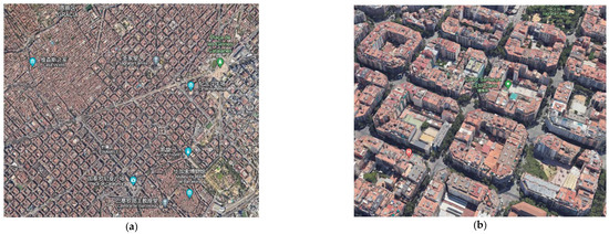
Figure 1.
The planning and layout of residential properties in Barcelona. (a) Barcelona Residential Layout Master Plan. (b) Aerial view of Barcelona residential layout.
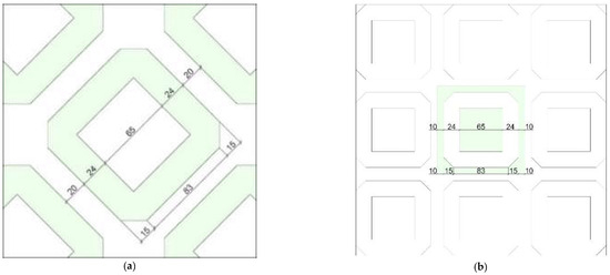
Figure 2.
Layout and scale of residential planning in Barcelona. (a) Barcelona Residential Layout Block Scale. (b) Spatial scale of Barcelona residential layout.
The block size of residential areas in northern Chinese cities (Figure 3 and Figure 4) is about 250 m squared, and the street width varies from 20 m to 40 m with the streets’ rank, with some parts of the area showing the characteristics of a huge street layout [10]. Residences often use point type or slab type with a north–south direction to form low FAR communities and rarely have an east–west layout [11]. In terms of residential scale, according to the “urban residential area planning and design code” issued in 2018, the maximum height of residential buildings is under 80 m, and the FAR should be below 3.1. As patios are not allowed to be used, the depth of residential buildings with ventilation on both sides is usually five times their height, therefore 15 m. In terms of function, business and retail will be designed separately or along the street, and the community generally has a residential function.
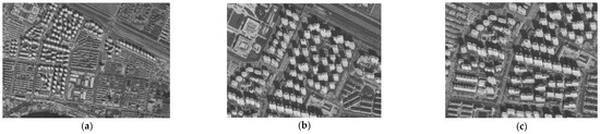
Figure 3.
The layout and scale of northern Chinese cities (Tianjin) in residential planning. (a) Tianjin residential planning and layout. (b) Tianjin point-style residential layout. (c) Tianjin panel house layout.
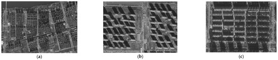
Figure 4.
The layout and scale of northern Chinese cities (Shenyang) in residential planning. (a) Shenyang residential planning and layout. (b) Shenyang point-style residential layout. (c) Shenyang panel house layout.
The layout of Barcelona’s 45-degree streets provides good sunlight conditions for building façades, streets, and even courtyard spaces [3]. This layout allows sunlight to reach the north room along the building façade, providing a certain amount of effective sunlight on the north façade [12], which is not achievable in residential layouts in northern China. This layout can effectively improve the smoothness of transportation, while also benefitting the overall visual effect of the city and the vitality of urban life. By drawing on the street layout experience of Barcelona, northern cities in China can consider introducing a certain degree of 45-degree street layout in new urban planning to improve the sunlight conditions of building spaces and urban public spaces, improve transportation conditions, and enhance the livability and sustainability of the city [13].
In summary, the main contributions of this article are as follows:
- Establishing a simulation model to analyze the sunlight conditions of residential layouts in Barcelona and Tianjin that provides a comparative perspective on the impact of urban design on sunlight exposure. Compared to the traditional north–south orientation, the 45-degree rotating street network significantly improves the sunlight intake of building façades, streets, and courtyards, consolidating the relevance of design to improving urban livability and sustainability. The sunlight conditions on the façades, ground level façades, streets, and courtyards of residential models in the northern Chinese cities of Tianjin and Barcelona were tested. We collected and analyzed the percentage of effective sunshine hours at different road network angles (0 degrees and 45 degrees), providing a basis for road network selection and façade and courtyard design in residential area planning.
- This study used Grasshopper to establish a residential area model. Based on the commonly used depth scale of residential areas in China, two types of residential depth parameters, 15 m and 18 m, as well as different road network angles, were set for the experiments. According to the 2018 Urban Residential Area Planning and Design Specification, Ladybug is used for sunlight analysis. Using parameterization to establish a simulation test model and using Ladybug for sunlight analysis can help visualize experimental results.
- In the planning of residential areas in China, two forms of housing are often used: point housing and panel housing. The selection and layout of housing forms will have a significant impact on the results of sunlight analysis. Therefore, two testing models, panel and point, were established for cities in northern China, and eight surrounding blocks were used as site occlusion objects. This study conducted sunshine simulation on 672 test models and optimized the planning of residential areas in northern cities in China.
- The study emphasizes the advantages of small neighborhoods and dense street networks, such as the Eixample district in Barcelona, in optimizing sunlight exposure. More than 2 h of sunlight exposure can effectively improve the hygiene conditions of dense road networks in the community and promote air circulation and ultraviolet disinfection within the community. In addition, sunlight can also improve the emotional and health status of residents, especially in densely populated living environments, where sufficient sunlight is particularly important for maintaining the mental health of residents. Therefore, when planning residential areas, full consideration should be given to the sunlight conditions of the residential area and its neighbors.
- Based on the research results, we propose optimized residential layouts for cities in northern China. This study proposes a residential layout in Barcelona, which has optimized overall sunlight performance and testing models for the inner courtyard, similar to the plot ratio of cities in northern China. This provides optimization and guidance for residential planning and design and enhances the sustainability of residential areas by enhancing buildings’ ability to capture solar energy.
The layout form of the dense road network in small street areas places more emphasis on the density of buildings and the continuity of blocks. This layout form can to some extent promote community sharing and social interaction, and the 45-degree road layout in Barcelona further enhances the sunlight conditions of buildings in the dense road network of small blocks and urban public spaces [14]. Therefore, in future research, we can continue to explore the advantages and disadvantages of densely connected residential layouts in small neighborhoods similar to Barcelona, such as Seattle, Paris, Saint Petersburg, and others. Shenyang, which has the same dimensions as Barcelona, is also one of the objects that can be used as a simulation or experiment in the future.
The main framework of this article includes the following aspects. Firstly, we review the relevant literature on urban sunlight exposure and its impact on sustainable development. Next, we provide a detailed introduction to our method, including the simulation models used to analyze the solar performance of residential layouts in Barcelona and Tianjin under various conditions. The following chapters introduce our research findings, compare the effects of different residential layouts on sunlight exposure, and discuss the impact of these research findings on urban sustainability. Finally, this article will provide recommendations for urban planning in northern Chinese cities and similar urban environments, emphasizing the importance of incorporating sustainable design principles to optimize natural sunlight exposure.
2. Related Work
In recent years, with the acceleration of urbanization, the problem of urban light environment has become increasingly prominent. According to statistics, the energy consumption of urban buildings accounts for more than 25% of the total energy consumption of society, and this proportion is still increasing year by year [15]. Tianzhen Hong’s research shows that urban buildings consume up to 70% of primary energy [16]. To address this challenge, the Chinese government has committed to achieving a carbon peak by 2030 and carbon neutrality by 2060 [16]. Therefore, reducing urban building energy consumption and improving building energy efficiency are urgent concerns [17]. Current research indicates that winter sunlight can effectively increase building energy consumption [18]; therefore, research and improvement in the building lighting environment have important practical significance.
Lu and Du [19] conducted a comprehensive analysis of the potential of light environment by using climate-based daylight simulation (CBDM) based on the vertical lighting intensity of building façades. The study found multiple relationships between sunlight potential and urban morphology and climate conditions. These findings provide some design strategies and guiding principles for early urban planning and design. However, further research is needed on how to improve sunlight availability in high-density residential areas in cold climates, as well as how to improve the sunlight conditions in courtyards, streets, and other areas of high-density residential areas [20].
Dan conducted an in-depth exploration of the relationship between the morphology of high-density areas in Shanghai and the potential for solar energy [21]. They simulated 1260 parameter scenarios and used custom workflows to simulate their solar radiation potential, in order to reveal the relationship between the two. Liao Kaihuai’s research suggests that Barcelona has a long history of revitalizing block public spaces, and in recent years, the street area planning reform aimed at revitalizing block road spaces has advocated for returning roads to pedestrians, providing a useful reference for promoting block-based residential models and block planning in China [8].
The impact of building group layout and urban form on building energy consumption has been confirmed by many studies [22]. Previous research has mainly focused on individual buildings, such as user energy consumption behavior, building thermal performance, and equipment and facilities, often neglecting how to tap into the enormous energy-saving potential inherent in urban form [15]. However, urban form is one of the important factors affecting the energy performance of buildings. For example, factors such as urban density, urban texture, and building type can all have an impact on building energy performance [15].
Tianzhen Hong’s research indicates that buildings in cities consume a large amount of disposable energy, and Urban Building Energy Modeling (UBEM) can provide a platform for evaluating the energy demand of cities [16]. With the development of computing tools, it has become possible to simulate building performance at the urban scale. However, urban buildings are not individual entities, and the urban environment also needs to consider the interactions between buildings and their surrounding urban environment [23].
Although the above studies have all directed the research direction of building energy consumption towards the level of urban layout, few people have paid attention to the importance of natural energy in the public spaces generated by group buildings, such as courtyards and streets. Secondly, most studies are focused on specific regions or types of buildings, lacking universality [24]. Finally, most studies have approached from a single perspective, such as urban density or building types, lacking comprehensiveness [25]. Therefore, future research needs to start from multiple perspectives, combining empirical and theoretical research, to comprehensively explore the relationship between urban form and building energy performance. At the same time, it is also necessary to conduct research on different regions and types of buildings in order to find more universal and applicable optimization strategies.
At present, research on building lighting environment mainly focuses on the following aspects: firstly, measuring and simulating the lighting environment of different types of buildings and analyzing the factors that affect the building lighting environment (such as window area, orientation, shading facilities, etc.); secondly, study of the impact of building lighting environment on human health and comfort; thirdly, exploration of technologies and strategies to improve the lighting environment of buildings, such as the application of green building materials, the combination of natural lighting and artificial lighting, etc.
Although research on architectural lighting environment has achieved certain results, there are still some problems and shortcomings. Firstly, current research mainly focuses on the analysis of the light environment of a single building or community, with relatively little research on the overall light environment of high-density residential areas. Secondly, existing research often overlooks the impact of climate conditions on the light environment when evaluating building lighting environments. Finally, there is insufficient research on strategies and technologies for improving the light environment in high-density residential areas in cold regions.
3. Methods
3.1. Simulation Model Formulation
The test unit in Barcelona is set according to the scale of the classic block in the Eixample district. During the simulation, the test areas include a small block in the center of a super block and the square formed by the center line of the surrounding street. The other 8 blocks in the super block are used as context.
The test model of northern Chinese cities uses slab type (model T1) or point type (model T3). The slab plan adopts a size of 15 × 60 m, and the height is 50 m. The point plan adopts a size of 25 × 25 m, and the height is 77 m. The FAR of the slab model is 2.6, and that of point model is 4.06. The surrounding shading model has the same scale as the test model (Figure 5 and Figure 6).
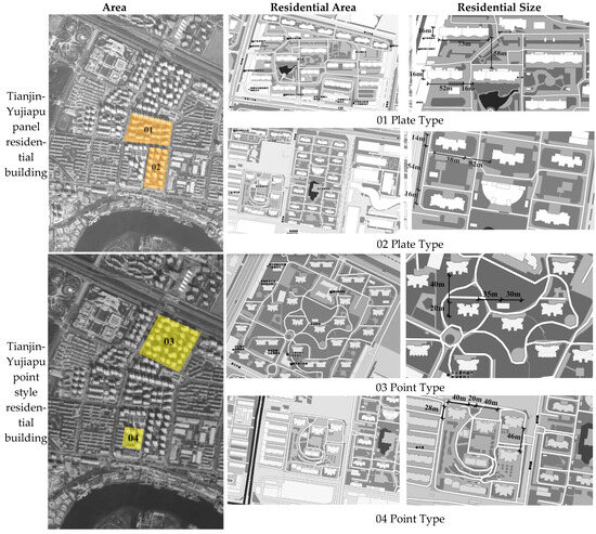
Figure 5.
Planning, layout and scale of high-density residential buildings in northern China.
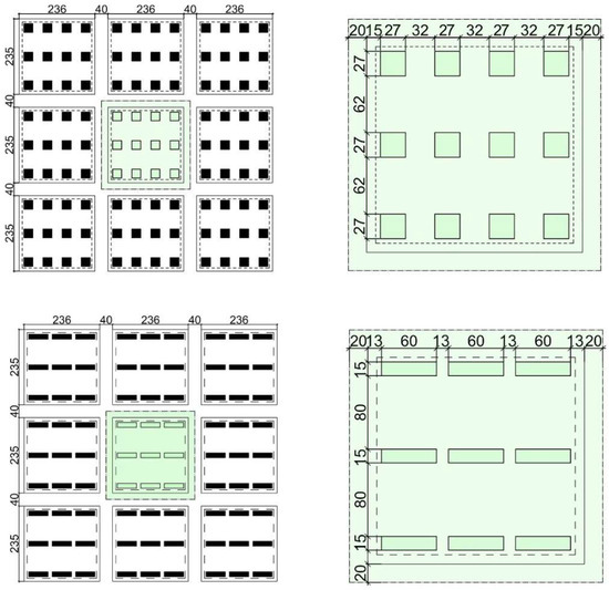
Figure 6.
Layout and scale of residential planning in northern Chinese cities.
3.2. Input Variable’s Types and Domain
3.2.1. Latitude
Latitude affects the sunshine condition of the whole residential area by affecting the incident angle of the sun. A variable-controlling approach is used, and the northern Chinese cities’ latitude (Tianjin 39.12° N) is set as a constant.
3.2.2. Land Development Intensity
The intensity of land development also greatly affects the sunshine performance of residential areas. Under the same conditions, the higher the intensity of land development, the worse the sunshine performance of residential areas. The FAR of the classic residential area model of the Barcelona Eixample district is relatively high, reaching 4.5. The top floor often uses the form of retreating two meters. In the case of the Calculate 9-story residential building, the FAR reaches 5.7. According to the standard of northern Chinese cities, in order to ensure the quality of residential areas, the FAR of newly built residences in northern Chinese cities must be less than 3.1. The subsequent comparison will adjust the FAR by changing residence’s scale groups to ensure that the comparison is carried out under a similar land development intensity.
3.2.3. Street Network Orientation
The rotation angle of the street network will affect the azimuth passage of solar incidence, and then affect the overall sunshine performance of residential buildings and their outdoor space. Therefore, the impact of the street network orientation on the sunshine performance of the two residential areas will be explored. The Barcelona model is used as a simulation model to compare the residential element of the north–south street network and the street network rotated 45 degrees. The result is shown in Table 1.

Table 1.
Influence of street network rotation angle in probe proportion of sunlight hours of building façade, streets and yards. (Yellow and green indicate excellent and good sunshine, respectively).
As can be seen clearly in Figure 7, for the street performance, Barcelona’s 45-degree rotated street network planning has obtained 143% more sunshine than the normal north–south street network in northern Chinese cities. This is due to the fact that after the street network rotates, the sun can shine along the side walls of the front row building to the north row building and enrich the sunshine for the north–south street, thus igniting the vitality of the street.
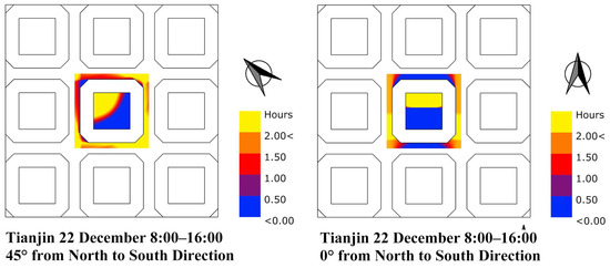
Figure 7.
Influence of street network rotation angle in sunlight simulation.
The phenomenon can also be confirmed from the building’s sunshine performance: although the north–south building has a good sunshine performance on the coldest day exceeding two hours of sunshine probes, its bottom façade (about two floors, that is, 8 m) has the largest proportion of sunshine that is less than half an hour, and there is a large amount of shade on the lower part of south main façade (Figure 8). Due to the north–south street network, northern Chinese cities can only increase the distance between buildings to ensure the sunshine on the building façade. This not only leads to the inability to implement a more suitable width of street for pedestrians, but also forces northern Chinese cities’ residences to use higher buildings to meet the demands of FAR, which is one of the reasons for the formation of northern Chinese cities’ existing urban layout.
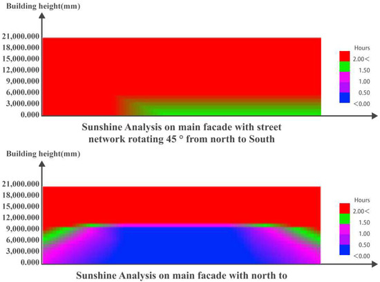
Figure 8.
Main façades comparison between 45°and 0°rotated street network.
For the reasons above, in the subsequent optimization process, the 45°rotated street network will be used as a constant.
3.2.4. Other Information
The accuracy of the test grid is 1 m, and the test time interval is 1 min. The lowest value displayed is 0 h, and the highest value is 2 h and above.
3.3. Output Variable
According to the existing sunshine standard in northern Chinese cities, residences require more than two hours of full window sunshine on the coldest day [26]. In the test, the data of sunshine satisfying two hours, between one hour and two hours, and less than half an hour are recorded, with two hours of sunshine as the main reference, one to two hours as supplementary sunshine, and less than half an hour as the areas with unfavorable sunshine.
Multistory buildings are different from single-story buildings. If there is no sunlight on the ground floor, it will greatly affect functional use and economic value. In the test, an 8 m high building façade was used to illustrate the sunshine conditions on the first and second floors’ façade. By counting the number of probes of different sunlight hours in the area proportion in the building façade, the lower part of the building façade, the streets and the courtyards of the test model, the sunshine condition of the overall residential layout can be revealed.
3.4. Thus, the Final Output Is
- The probe proportion of sunlight hours in building façades is less than 0.5 h (PPF < 0.5);
- The probe proportion of sunlight hours in building façades is within 0.5,1 h (0.5 ≤ PPF < 1);
- The probe proportion of sunlight hours in building façades is within 1,2 h (1 ≤ PPF < 2);
- The probe proportion of sunlight hours in building façades is greater than 2 h (PPF > 2);
- The probe proportion of sunlight hours in the lower part of building façades is less than 0.5 h (PPF < 0.5)
- The probe proportion of sunlight hours in the lower part of building façades is greater than 2 h (PPF > 2);
- The probe proportion of sunlight hours in streets is less than 0.5 h (PPF < 0.5)
- The probe proportion of sunlight hours in streets is greater than 2 h (PPF > 2)
- The probe proportion of sunlight hours in courtyards is less than 0.5 h (PPF < 0.5)
- The probe proportion of sunlight hours in courtyards is greater than 2 h (PPF > 2)
Test Process
Under the same meteoric conditions and similar land development intensity, this paper attempts to compare the sunshine performance of the Binhai district in the northern Chinese cities and the Eixample district residential area in Barcelona. The current FAR of Barcelona is close to about 4.5, which is far beyond the requirements of code in northern Chinese cities. At the same time, we found from the comparison of the street network angle that although the test model of Barcelona has good performance in the street, it is not satisfactory in terms of the sunshine performance of building façades and courtyards. The sunshine performance of the courtyard and the building façade is mainly restricted by the shadow length of the inner wall of courtyard. The shadow length itself is affected by the building height and the length of the yard. The poor sunshine performance of the courtyard and even the overall building façade actually reflects the influence of the high FAR of the Barcelona test model.
By combining the scales group of existing buildings in the Barcelona expansion area, we found the following:
- Street width {20, 24};
- Block size [87, 144];
- Building depth [15, 30];
- Building layers [6, 9].
A total of 672 test models were simulated to obtain the optimized layout model of the Barcelona residential area with better sunshine performance and a similar FAR to the northern Chinese cities. The northern Chinese cities’ sunshine standard was used in the test, that is, the effective period of the test was from 8:00 a.m. to 16:00 p.m. on the coldest day. This article used the Ladybug plug-in based on Rhino & Grasshopper’s parametric platform to simulate sunshine, the colibri2.0 plug-in in the TT toolbox to collect data and Design Explorer to classify and screen the data. By setting the screen conditions, optimization and solution of this problem affecting multiple factors can jointly be solved (Figure 9).
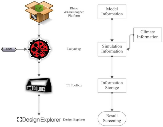
Figure 9.
Test workflow used in paper.
This section mainly establishes the simulation models used to test the sunlight performance of residential models in Barcelona and Tianjin under different conditions. By analyzing the design of testing units in Barcelona, this study investigates the classic block size based on the Eixample district, as well as the experimental model in Tianjin, based on the plot ratio of slab and point residential buildings. The experiment provides a detailed description of the types and domains of input variables, including latitude, land development intensity, and street network positioning, as well as how they affect sunlight conditions in residential areas.
Based on the above, we explore the impact of changing the perspective of the street network on sunlight performance. By analyzing the output variable of the experiment—the proportion of different sunshine times—it was found that the 45 ° rotation street network is superior to the traditional north–south street layout in improving sunshine performance. These variables can also be used to evaluate the sunlight conditions of building façades, streets, and courtyards.
Finally, through simulation testing, an optimized residential layout in Barcelona was proposed, which has improved overall sunlight performance in the inner courtyard and a plot ratio similar to cities in northern China. This provides optimization guidance for residential planning and design, enhancing the sustainability of residential areas by enhancing buildings’ ability to capture solar energy.
4. Results
4.1. The Optimization Results of Barcelona Form under Northern Chinese Cities Climate Conditions
The screening conditions in the process of optimization include: (1) the shadow length of the unfavorable façade in the courtyard should be shorter than or equal to 3/10 of the length of the façade; (2) the probe proportion of sunlight hours that is greater than two hours in urban exterior space, including PPS and PPY, should be more than 33%. These screening conditions ensure that there are enough rooms in the wall of the courtyard to meet the sunshine requirements and effectively reduce the proportion of unfavorable sunshine area (PPF < 0.5) on the building façade; also, on the coldest day in winter, these conditions guarantee that one third of the urban exterior space can obtain sufficient sunshine, which is in line with the code standards for central green space. According to the above conditions, the maximum plot ratio of the result test model is 5.13 (model B3). A total of 48.6%, 42.6% and 42.9% of the area of the buildings, streets and courtyards have sunlight hour probes for more than two hours. The sunshine performance is up to the standard, and the FAR of the test model is too high to be achieved by the existing residential form of northern Chinese cities.
It should be noted that the classic 24 m depth of the block buildings in Barcelona’s Eixample district, even the 30 m depth of the famous Mira apartment, relies on its various styles of lighting patios to meet the basic sunshine demand. It is not recommended to adopt patio lighting in northern Chinese cities. According to the “green building evaluation standard” of China, the ratio of floor height to depth of the double Sunshine Building is 1:5 (Borong Lin, 2015) [27], and in practice, this ratio is extended to 1:6. After adding screening condition (3) that the depth of the house is less than 18 m, the maximum FAR of the test model is 4.03 (model B4), buildings, streets and courtyards accounted for 48.2%, 49.1% and 38.3% of the proportion of probes whose sunlight hours are greater than two hours. The sunshine performance was up to standard. The land development intensity was similar to the point-type high FAR model in northern Chinese cities. It is a usable model for residential layout in northern Chinese cities using a small block and dense street planning method.
In order to plan a livable city, a block size of about 400 m was chosen to facilitate pedestrians in Barcelona. Usually, the maximum comfort pedestrian distance is 500 m (Juanjuan You, 2010) [28] which becomes the limit value of the longest path in the block. Therefore, the limit range of the block size is (4) less than 115 m according to the maximum block size. After adding the (5) screening condition that the building depth less than 15 m, the low plot ratio model (B1) is selected. The probe proportion of urban exterior space with more than two hours of sunlight is 56.9% in the courtyard and 37.9% in the road. The probe proportion of sunlight hours in building façades greater than 2 h is 50%. All rooms meet the livable requirements of one-side lighting. The FAR of 3.0 is also similar to the land development intensity of the existing residential layout in the Binhai district of the northern Chinese cities (Table 2), which makes the B2 model applicable for residential layout in northern Chinese cities under the guidance of the small block and dense street network planning method.
Table 2.
Optimization results under two kinds of constraints.
4.2. Comparison of Sunshine Simulation Results of Residential Areas in Two Cities
When comparing the high and low FAR test model groups with similar land development intensity of two costal cites, the result is as follows (Figure 10):
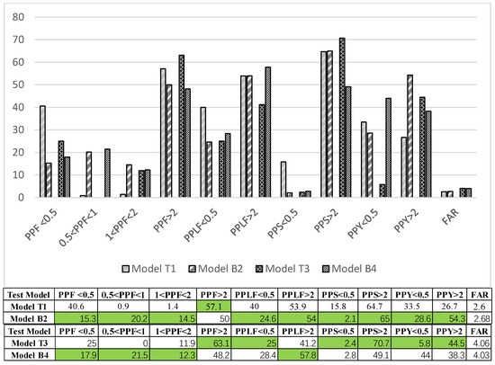
Figure 10.
Comparison of residential layout in northern Chinese cities and Barcelona in probe proportion of sunlight hours of building façade, streets and yards (Green indicates good sunlight).
When FAR is less than 3.1, which is in line with Chinese code, the optimized Barcelona test model (model B1) has appreciable advantages in the building façade, the lower part of the building façade, and the courtyard. Two different layouts’ proportion of probes whose sunlight hours is greater than 2 h both exceeded 50%. In the meantime, Barcelona’s preference is superior to that of the northern Chinese cities in PPF < 0.5, PPF ∈ [0.5,1), PPF ∈ [1,2), which indicates that there is more additional sunlight in the inferior part of the façade and Barcelona’s façades obtain more evenly distributed sunshine.
Street sunshine is influenced by factors including surrounding building density, street network orientation, and street width. Northern Chinese cities’ street width reaches 70 m in some areas when measuring both walks and drives. Wider streets in northern Chinese cities’ residential layout deliver an equivalent sunlight performance to Barcelona’s layout, which differs from the comparison of street network orientation using the same test model in the previous article. But there is no denying that wider streets lead to the problems of low-density street networks, uncomfortable pedestrian experience, and accumulating more harmful radiation in summer.
In terms of the courtyard’s sunshine performance, as a result of long-term ignorance of sunlight in central green spaces in China, the common row-type layout of residential area’s outdoor space in China can hardly reach the standard that 1/3 of the central green space is bathed in more than 2 h of sunshine on the coldest day. This inferiority is shown in the data too. The row-type layout courtyard has only 23 percent of the area reaching the demands of two hours of sunshine.
With the growth of the population, when it comes to the high-density test model group, the sunshine performance reverses. The Barcelona model reaches the standards in all parts of the building and the city outdoor spaces whereas the northern Chinese cities have a better performance in terms of building façade and street sunlight hours exceeding two hours.
To put it in a nutshell, Barcelona’s layout uses a 45°-rotated street network to obtain more sunshine through the azimuth passage and diminish building intervals, achieving a high-density street network and generating a closely connected city. However, the FAR now in Barcelona’s Eixample district is beyond the expectation of livable standards of urban planning scholars. By slightly adjusting the depth and street width of the test model, the residential area’s sunshine and living conditions can be greatly improved. An optimized Barcelona test model has a similar FAR to northern Chinese cities’ land development density and obtains better sunshine in lower parts of building façades, streets and courtyards. In terms of the whole building façade, it enjoys more evenly distributed sunshine. In the high-density test model comparison, despite the fact that some parts of the northern Chinese cities’ sunshine performance are superior to Barcelona’s, Barcelona test model’s data also fulfills the livable demand, which proves the optimized Barcelona test model’s feasibility in northern Chinese cities’ urban practices.
This section mainly compares the impact of residential layouts in Tianjin and Barcelona in terms of sunlight conditions. The study conducted an in-depth analysis and comparison of two different urban layouts through simulation models. Through simulation, it was found that a 45° rotating street network can provide more sunlight for the side walls and north side of houses of buildings, while reducing the spacing between buildings, achieving a high-density street network. A residential model with a plot ratio higher than the existing residential area planning in northern Chinese cities was obtained under the condition of meeting the sunlight performance standards. This indicates that a reasonable road network angle and adjustment of the plot ratio have an important impact on improving the sunlight conditions and livability of residential areas. Research has found that the small block and dense street network planning model in Barcelona is of great significance in improving the livability and sustainability of the city. It is recommended that northern Chinese cities consider introducing a certain degree of 45-degree street layout in their new urban planning to improve the sunlight conditions of building spaces and urban public spaces.
5. Discussion
The optimization results of sunlight simulation on a total of 672 test models show that the road network angle greatly affects the sunlight conditions of buildings, streets, and courtyards, whereas the plot ratio greatly affects the livability of residential models. A reasonable angle of the road network is beneficial for increasing the range of sunlight exposure, providing more sunlight for the side walls of buildings and the northern row of houses, and supplementing sunlight for north–south streets, thereby maintaining street vitality. At the same time, the changes in road network angles have certain limitations in optimizing the sunlight conditions in courtyards. The change in plot ratio has a significant impact on the sunlight conditions in the courtyard. Under the guidance of the small block dense road network planning model, when using the northern Chinese cities point high plot ratio model, the depth range of the house can be specified within 18 m; to improve the livability of the living model, the depth range of the house can be set within 15 m.
5.1. Effectiveness of the Test Model
For a more reasonable comparison, the test model formulation based on morphology and optimization via genetic algorithm are adopted in this paper. Nevertheless, the test model can only represent the typical type of residential area in both Barcelona and northern Chinese cities. There are still some characteristics of the residential layout pattern variation in northern Chinese cities in the Binhai district during urban practice for multiple use, such as the mixture of slab and point-type high-rise buildings, multistory and high-rise mixed, slab residential enclosures with central green spaces, etc. that have not been explored. These patterns need to be further refined and compared.
5.2. Feasibility of the Conclusion
The discussion on the planning mode of a dense street network and small blocks in Barcelona is aroused under the influence of new urbanism, which advocates for human experience-oriented street and public space. Large-scale planning is imposing from a bird’s-eye view, but when we change the perspective to a human’s view, its weakness in transportation effectiveness and space vitality becomes very obvious. This shows the significance of the discussion on the residential layout and scale of small blocks suitable for northern Chinese cities. At the same time, in practice, as long as the intensity of land development is acceptable from a big-block perspective, the Barcelona model with a high FAR can be mixed with the model with a low FAR for more flexible use in northern Chinese cities.
6. Conclusions
This study examined the differences between the northern Chinese cities’ board point layout and Barcelona’s small block layout, using the Ladybug plugin based on the Rhino&Grasshopper parameterization platform for sunlight simulation, collecting data using the colibri2.0 plugin in TT toolbox, and using Design Explorer for data classification. The sunlight conditions were simulated for street width {20, 24}, block size [87, 144], building depth [15, 30], and building layers [6, 9] at different sunlight angles in the neighborhood. And through genetic algorithm optimization, a residential model with a plot ratio higher than the existing residential area planning in northern Chinese cities was obtained under the condition of meeting the sunlight performance standards. The following conclusions can be drawn:
- In the dimensions of northern Chinese cities (39.12° N), with a plot ratio of about 3.1 and road network angles of 45 degrees and 0 degrees, the test found that the overall sunlight conditions of the residential model were better when the road network angle was 45 degrees than when the road network angle was 0 degrees. That is to say, under similar climate conditions and low land development intensity, the overall sunlight conditions of Barcelona were better than those of the northern Chinese cities’ layout with houses facing north and south.
- In Barcelona, the current plot ratio is close to 4.5. Using the same dimensional conditions mentioned above, it was found that although the Barcelona test model (with a road network angle of 45 degrees) performs well on the streets, its performance in building façades and courtyard sunlight is lower than that of the residential model with a plot ratio of about 3.1. Therefore, when planning residential areas, the angle of the road network should be adjusted appropriately, fully utilizing the ability of the sun to shine along the side walls of the front row buildings to the north row buildings, and supplementing sunlight for north–south streets to maintain street vitality.
- A 45 degree north–south turn is a key factor in forming a small block and dense street network. In the comparison of low plot ratio residential areas, the residential layout in Barcelona had more advantages in the lower part of façades, streets, and courtyards, and had a more balanced performance on the building façades. Both test models can meet the sunshine standard when the density is greater than 3.1 FAR. The northern Chinese cities’ layout model has advantages in building façades, whereas the Barcelona layout model has more advantages in the external space of the city. For northern cities in the mid-latitude or even low-latitude range of 39–41° N, these two modes can be recommended for layout.
Author Contributions
Conceptualization, Y.Z.; Methodology, Y.Z.; Validation, W.C.; Writing—review & editing, W.C.; Supervision, Z.Y. and Z.T.; Project administration, Y.L. All authors have read and agreed to the published version of the manuscript.
Funding
This research received no external funding.
Data Availability Statement
Data are contained within the article.
Conflicts of Interest
The authors declare no conflict of interest.
References
- Liu, K.; Xu, X.; Huang, W.; Zhang, R.; Kong, L.; Wang, X. A multi-objective optimization framework for designing urban block forms considering daylight, energy consumption, and photovoltaic energy potential. Build. Environ. 2023, 242, 110585. [Google Scholar] [CrossRef]
- Li, J.; Zheng, B.; Bedra, K.B.; Li, Z.; Chen, X. Effects of Residential Building Height, Density, and Floor Area Ratios on Indoor Thermal Environment in Singapore. J. Environ. Manag. 2022, 313, 114976. [Google Scholar] [CrossRef] [PubMed]
- Aghamolaei, R.; Azizi, M.M.; Aminzadeh, B.; Mirzaei, P.A. A tempo-spatial modelling framework to assess outdoor thermal comfort of complex urban neighbourhoods. Urban Clim. 2020, 33, 100665. [Google Scholar] [CrossRef]
- Cheng, V.; Steemers, K.; Montavon, M.; Compagnon, R. Urban Form, Density and Solar Potential. In Proceedings of the PLEA 2006—23rd International Conference on Passive and Low Energy Architecture, Geneva, Switzerland, 6–8 September 2006. [Google Scholar]
- Bian, H. The Study on Pattern of Small Block Residential Space—Taking Northern Chinese Cities as an Example. Ph.D. Thesis, Northern Chinese Cities University, Tianjin, China, 2010. [Google Scholar]
- Zhang, R. A Study on Public Space in a Small City in Barcelona. Ph.D. Thesis, Zhejiang University, Hangzhou, China, 2013. [Google Scholar]
- Huang, J.; Selda, S. The Thinking and System of Cerda’s Barcelona Eixample Plan. Ph.D. Thesis, Zhejiang University, Hangzhou, China, 2012. [Google Scholar]
- Liao, K.; Cai, Y. Reshaping the Publicity of Block Streets: The Conception, Practices and Inspirations of Barcelona’ Superblocks Planning. Urban Plan. Int. 2018, 33, 98–104. [Google Scholar] [CrossRef]
- Urbano, J. The Cerdà Plan for the Expansion of Barcelona: A Model for Modern City Planning. Focus 2016, 12, 13. [Google Scholar] [CrossRef][Green Version]
- Liu, J. Research on the Evolution of Northern Chinese Cities Residential Planning Based on the Concept of New Urbanism. Ph.D. Thesis, Northern Chinese Cities University, Taiyan, China, 2014. [Google Scholar]
- Hong, B.; Lin, B.; Hu, L.; Shuhua, L. Optimal tree design for sunshine and ventilation in residential district using geometrical models and numerical simulation. Build. Simul. 2011, 4, 4. [Google Scholar] [CrossRef]
- Gaowa, J.W.; Tuo, Y. The Design Strategy for Improving the Sunshine Condition of Residential Area in Severely Cold Region. Appl. Mech. Mater. 2014, 3309, 584–586. [Google Scholar] [CrossRef]
- Alberini, C. The relationships between port and city in the Mediterranean basin. The cases of Barcelona and Genoa. PORTUSplus J. RETE N 2021, 11, 2039–6422. [Google Scholar]
- Peronato, G.; Nault, E.; Cappelletti, F. A parametric design-based methodology to visualize building performance at the neighborhood scale. In Proceedings of the Building Simulation Applications 2015, Bolzano, Italy, 4–6 February 2015. [Google Scholar]
- Liu, K. Optimization Strategies for Urban Morphology in Hot Summer and Cold Winter Regions Driven by Energy Performance. Master’s Thesis, Southeast University, Nanjing, China, 2021. [Google Scholar]
- Hong, T.; Chen, Y.; Luo, X.; Luo, N.; Lee, S.H. Ten questions on urban building energy modeling. Build. Environ. 2020, 168, 106508. [Google Scholar] [CrossRef]
- Montavon, M.; Scartezzini, J.L.; Compagnon, R. Comparison of the solar energy utilization potential of different urban environments. In Proceedings of the Plea 2004 Proceedings of 21st Conference on Passive and Low Energy Architecture, Eindhoven, The Netherlands, 19–21 September 2004; pp. 1733–1748.
- Li, J. Urban Design Theory and Method Based on Sunshine Adaptability. Ph.D. Thesis, Southeast University, Nanjing, China, 2018. [Google Scholar]
- Lu, M.; Du, J. Dynamic Evaluation of Daylight Availability in a Highly-dense Chinese Residential Area with a Cold Climate. Energy Build. 2019, 193, 21. [Google Scholar] [CrossRef]
- Compagnon, R. Solar and daylight availability in the urban fabric. Energy Build. 2004, 36, 321–328. [Google Scholar] [CrossRef]
- Zhu, D.; Song, D.; Shi, J.; Fang, J.; Zhou, Y. The Effect of Morphology on Solar Potential of High-Density Residential Area: A Case Study of Shanghai. Energies 2020, 13, 2215. [Google Scholar] [CrossRef]
- Caroline, H.; Andreas, A.; Paul, F. Evaluation of energy supply and demand in solar neighborhood. Energy Build 2012, 49, 335–347. [Google Scholar]
- Vargova, A.; Köhler, S.; Hötzel, S.; Schröter, B.; Vranayova, Z.; Kaposztasova, D. Transformation of Urban Spaces: The Impact of Green Roofs in Košice, Slovakia. Sustainability 2024, 16, 22. [Google Scholar] [CrossRef]
- Chatzipoulka, C.; Compagnon, R.; Kämpf, J.; Nikolopoulou, M. Sky view factor as predictor of solar availability on building façades. Sol. Energy 2018, 170, 1026–1038. [Google Scholar] [CrossRef]
- Reyes, M.; Pérez, G.; Coma, J. Sustainability Factor for the Cost–Benefit Analysis of Building-Integrated Greenery Systems. Sustainability 2024, 16, 157. [Google Scholar] [CrossRef]
- Mohajeri, N.; Upadhyay, G.; Gudmundsson, A.; Assouline, D.; Kämpf, J.; Scartezzini, J.-L. Effects of urban compactness on solar energy potential. Renew. Energy 2016, 93, 469–482. [Google Scholar]
- Borong, L. Green Building Evaluation Standard—Indoor Environment Quality. Constr. Sci. Technol. 2015, 2015, 30–33+37. [Google Scholar]
- You, J. Preliminary Study on Urban Block Type Residential Area Planning in China. Ph.D. Thesis, Chongqing University, Chongqing, China, 2010. [Google Scholar]


Disclaimer/Publisher’s Note: The statements, opinions and data contained in all publications are solely those of the individual author(s) and contributor(s) and not of MDPI and/or the editor(s). MDPI and/or the editor(s) disclaim responsibility for any injury to people or property resulting from any ideas, methods, instructions or products referred to in the content. |
© 2024 by the authors. Licensee MDPI, Basel, Switzerland. This article is an open access article distributed under the terms and conditions of the Creative Commons Attribution (CC BY) license (https://creativecommons.org/licenses/by/4.0/).