Article

Investigating the Impact of Streetscape and Land Surface Temperature on Cycling Behavior

1
College of Physical Education and Health Science, Guangxi Minzu University, Nanning 530008, China
2
School of Recreational Sports and Tourism, Beijing Sport University, Beijing 100084, China
*
Author to whom correspondence should be addressed.
Sustainability 2024, 16(5), 1990; https://doi.org/10.3390/su16051990
Submission received: 31 January 2024 / Revised: 23 February 2024 / Accepted: 27 February 2024 / Published: 28 February 2024
(This article belongs to the Section Health, Well-Being and Sustainability)

Abstract

:
Cycling is a flexible way of traveling that can promote the development of urban public transportation. Previous studies on the influence of cycling have focused more on the cyclists themselves, ignoring the influences of the features of natural environments, such as streetscapes and land surface temperatures (LSTs), on cycling behavior. Therefore, in this study, street view image data and Landsat 8 imagery were utilized to extract streetscape and LST features; in particular, a framework was established for a single-indicator analysis and a multiple-indicator interaction analysis based on the random forest model with GeoDetector. The model was used to explore the effects of streetscapes and surface temperatures on cycling behavior. The results of this study for the main urban area of Beijing show that (1) high-density buildings and high population activity exacerbated the heat island effect at the city center and certain areas in the east, with the highest LST reaching 46.93 °C. In contrast, the greenery and water bodies in the northwestern and northeastern areas reduced the LST, resulting in a minimum temperature of 11.61 °C. (2) The optimal analysis scale was a 100 m buffer pair, and the regression fitting accuracy reached 0.83, confirming the notable influences of streetscape and LST characteristics on cycling behavior. (3) The random forest (RF) model results show that the importance of LST features and vegetation and sky conditions exceeded 0.07, and a reasonable sky openness and open building ventilation became the first choices for promoting cycling behavior. (4) According to the GeoDetector model, the LST features alone exhibited an importance of more than 0.375 for cycling behavior, while interactions with streetscapes greatly reduced the negative effect of LST on cycling behavior. The interaction between walls and plants reached 0.392, while the interaction between multiple environmental factors and greenery and favorable ventilation counteracted the negative impact of high-temperature heat waves on the residents’ choice of bicycles.

1. Introduction

The current substantial increase in global temperature has sparked widespread concern, and climate change is emerging as a central topic of discussion in societies worldwide [1]. With the frequent occurrence of extreme weather events, such as heat waves, torrential rains, and floods, humans are increasingly being affected by the challenges posed by environmental changes [2,3]. Against this backdrop, urbanization has surged, concentrating the majority of the population in urban areas. Rapid urbanization growth has propelled city life into the mainstream, while it has also triggered a series of environmental problems [4,5]. There is an increasing focus on maintaining physical health in complex and densely populated urban environments, where lifestyles and surroundings often exert direct and far-reaching impacts on human health [6,7]. The exploration of a sustainable lifestyle and health promotion strategies has become an urgent issue.
To maintain their health, an increasing number of people are choosing to ride bicycles, not only as a means of transportation but also as a beneficial form of exercise [8,9]. Cycling serves not only as a straightforward means of transportation but also as a beneficial form of exercise. Through cycling, individuals can engage in a comprehensive workout that enhances cardiorespiratory fitness, builds physical strength, and triggers the release of beneficial hormones, effectively alleviating stress [10,11,12]. This full-body exercise not only helps maintain flexibility but also bolsters the immune system, promoting resilience [13]. In addition to its positive impact on individual physical health, cycling, as an environmentally friendly mode of transportation, aligns with society’s current emphasis on sustainable development and low-carbon living [14]. Compared to traditional modes of transportation, cycling produces no harmful exhaust fumes, thereby reducing air pollution and contributing to improved urban air quality [15]. Moreover, cycling catalyzes socialization, encouraging people to embrace healthier and more environmentally friendly lifestyles. This collective effort can contribute significantly to building a more sustainable society. Despite the recognized positive effects of cycling, there is a notable lack of in-depth analyses regarding the influence of streetscapes and LSTs on cycling behavior. A thorough investigation into the impacts of streetscapes can assist urban planners in designing cycling paths and environments that enhance both comfort and safety for cyclists [16]. Simultaneously, acknowledging the effects of LSTs, especially in hot climates, is crucial. Providing cyclists with appropriate protection and a cooler environment can incentivize more individuals to choose cycling, thereby steering cities toward a healthier and more sustainable direction [17].
In the field of urban ecology and sustainable transportation, researchers have delved into the impact of urban environments on residents’ choices of cycling [18]. Previous studies have indicated that improving the urban environment through green infrastructure and sustainable city planning can encourage residents to choose cycling, fostering a healthier lifestyle [19]. Measures such as constructing dedicated bike lanes, optimizing urban green spaces, and planning roadside vegetation significantly encourage residents to opt for cycling as their primary mode of transportation [20]. Specifically, with the acceleration of urbanization, the development of sustainable transportation provides a new environment for cycling [21]. Cities enhance cycling by constructing extensive bike lanes and promoting the development of cycling-friendly public transportation. This guides residents toward eco-friendly commuting, contributing to increased urban resilience in addressing environmental challenges arising from urbanization [22]. Existing research consistently demonstrates the close connection between urban planning, especially street landscape planning, ecological environments, and cycling behavior [23]. However, there is currently limited research on the specific impact of street landscapes and LSTs on cycling behavior. Therefore, the purpose of this study is to explore the influence of street landscapes and LSTs on cycling behavior, aiming to enhance residents’ acceptance of cycling. This exploration holds the potential to promote the widespread use of bicycles in urban life, guiding the development of healthier and more sustainable urban patterns and resident lifestyles.
The rationale for investigating streetscapes and LSTs lies in their direct impact on the experience and feasibility of urban cycling. First, cycling activities primarily occur on urban roads, and the surrounding landscape not only influences the sensory experience of cyclists but also significantly shapes their behavioral choices [24,25]. A visually appealing streetscape can evoke excitement and enhance the pleasure of cycling, potentially encouraging more individuals to embrace cycling as a delightful and healthy mode of transportation [26]. For urban planners, the meticulous design and arrangement of streetscapes can create a more attractive cycling environment, thereby improving the overall quality of life for city residents [27]. Second, in cities located in middle and low latitudes, elevated summer temperatures often impose a constraint on cycling [28]. Heat can lead to discomfort for cyclists, affecting both the enjoyment and safety of cycling. Consequently, conducting a thorough examination of LST effects on cyclists, particularly during the hot season, becomes crucial for devising appropriate thermal protection strategies [29]. By comprehending the distribution and fluctuations of LSTs, urban planners can implement targeted greening initiatives, construct shade facilities, and adopt other strategies to craft a more pleasant environment for cyclists, thereby enhancing the appeal of cycling [30]. In conclusion, a comprehensive study of the impacts of streetscapes and LSTs on cycling behavior is essential for obtaining a nuanced understanding of the feasibility and adaptability of urban cycling. This knowledge is instrumental in promoting the widespread adoption and sustainability of cycling in urban life.
The existing challenges primarily revolve around the scarcity of data and limited analytical methods. Previous studies have been limited by inadequate data for thoroughly analyzing the impacts of streetscapes and LSTs on cycling behavior. However, with the ongoing advancements in big data and machine learning technologies [31,32], the integration of streetscape data has become feasible. This technological progress offers new avenues for examining the relationship between the urban environment and cycling. Utilizing machine learning algorithms, such as random forests [33], enables a more comprehensive assessment of the combined effects of streetscapes and LSTs on cycling behavior, addressing the limitations of prior research. These innovative tools are expected to provide a more exhaustive and in-depth understanding of the influence of the urban environment on cycling. This study aimed to analyze the effects of streetscapes and LSTs on cycling behavior, contributing scientific insights for urban planning and cyclists.

2. Methodology

This study comprises three main components (refer to Figure 1). Initially, the primary phase involved the retrieval of LST and streetscape measurements. LST retrieval was accomplished through the use of the radiative transfer equation algorithm, while streetscape measurements relied on streetscape images and the PSPNet semantic segmentation network. Subsequently, in the second phase, we devised six sets of comparative tests to delineate buffers along the cycling routes individually. These buffers were then overlaid to extract factor lists within their respective spatial confines. Finally, in the third phase, comparative experiments were used to determine the optimal analysis scale. This assessment involved evaluating the significance of individual factors using the random forest algorithm and exploring the interaction effects between two factors through the GeoDetector method.

2.1. Study Area and Data

This study focused on the main urban areas of Beijing, encompassing Dongcheng District, Xicheng District, Haidian District, Chaoyang District, Tai District, and Shijingshan District. These districts constitute the primary support zone for the four central districts of China’s capital city, covering approximately 1385 km2, equivalent to 8.4% of the total area. The resident population in this region is approximately 10,988,000 people, constituting 50.2% of the total population. The area is characterized by high population density, advanced urban development, significant economic prosperity, and a considerable number of residents actively embracing healthier lifestyles, such as cycling.
The Landsat 8 image used in this study was radiometrically calibrated and sourced from the Geospatial Data Cloud platform (www.gscloud.cn, accessed on 15 September 2023). In order to mitigate the prolonged impact of the COVID-19 epidemic on the contribution of human activities to Land Surface Temperature (LST) changes, we opted for remote sensing images captured before the outbreak. Simultaneously, taking into account the high level of development in the central urban area of Beijing, we selected the 2019 images exhibiting minimal changes in the built environment. Captured on 2 September 2019, at 10:52 p.m., the images were taken under clear and cloudless weather conditions. Additionally, 162,172 street view images within the study area were obtained through the Baidu Map API to assess streetscape features. Road network data were sourced from OpenStreetMap (OSM) data. To gather cycling behavior data, Lushu APP data from June 2023 were acquired from the study area. The app is widely used among urban cycling enthusiasts for providing professional cycling route planning and design. These data were instrumental in characterizing the cycling behavior patterns of residents in the designated region. The comprehensive approach of integrating Landsat 8 imagery, street view images, and cycling behavior data provided a robust foundation for our analysis, enabling a holistic understanding of the interplay between urban environments and cycling habits (Figure 2).

2.2. Land Surface Temperature Retrieval

In this paper, we used the Landsat 8 TIRS band 10 (TIRS 10) as a data source to retrieve and study the LSTs in the study area based on the radiative transfer equation algorithm to characterize and quantify the thermal environment of the city [34].
L sensor   = ε B T s + 1 ε L τ + L
T s = K 2 ln ( K 1 B T s + 1 )
In the equation, L sensor   is the radiant brightness at satellite altitude received by the sensor, ε is the surface-specific emissivity, τ is the atmospheric transmittance, L is the atmospheric downgradient radiant brightness, and B ( T s ) is the radiant brightness of a blackbody whose temperature is T s . The values of τ (atmospheric transmittance), L (atmospheric downgradient radiance), and L (atmospheric uplink radiance) are τ = 0.78, L = 1.69, and L = 2.80, respectively, according to the imaging time and central latitude and longitude of the image used on the NASA website (http://atmcorr.gsfc.nasa.gov/, accessed on 17 September 2023). The thermal infrared band of the Landsat8 data used in this study was the 10th band, which is in the lower atmospheric absorption region. The inverse function of Planck’s equation was used to obtain the true LST, where K 2 = 1321.08 and K 1 = 774.89.

2.3. Streetscape Measurements and Comparative Experimental Design

The PSPNet model, short for the pyramid scene parsing network, is a widely used semantic segmentation architecture designed to accurately classify individual pixels in an image into different categories to achieve fine-grained segmentation at the pixel level [35]. PSPNet functions by partitioning an image into a series of regions, conducting in-depth feature extraction and classification on each region, and subsequently generating segmentation results for the entire image. Specifically, PSPNet uses a pyramid pooling strategy in the image segmentation process to divide the image into different regions, each of which undergoes an in-depth feature extraction and classification process. This multi-scale processing allows the model to focus on both local details and global semantic information to better understand the structure and semantic content of the image. By performing fine feature extraction for each region, PSPNet is able to effectively capture the features of various objects in the image and realize accurate segmentation of the image. In the context of our study, the PSPNet model served as a pivotal tool for extracting features from streetscape images and enabling the automated recognition of streetscape elements in batches. Through semantic segmentation of street scene images, the PSPNet model facilitates the classification of various object categories, including but not limited to roads, walls, buildings, skies, trees, shrubs, and grasses. This approach allowed for a nuanced understanding of the streetscape, delineating different elements within the urban environment through sophisticated feature extraction and segmentation. The use of the PSPNet model in this study ensured the use of a robust and efficient methodology for analyzing and categorizing streetscape features at the granular level [36]. This enabled our study to provide detailed analysis and fine-grained categorization of street view images, providing reliable data support for the analysis.

2.4. Exploring the Effects of Streetscapes and Land Surface Temperatures

2.4.1. Feature Importance Assessment Based on the Random Forest Algorithm

The rationale behind employing the random forest model for variable impact studies is rooted in its ability to address nonlinear and intricate relationships among variables, as well as its ability to measure feature importance. The rationale behind evaluating feature importance in the random forest model is grounded in two key principles: bagging and the cumulative assessment of feature importance. In essence, the approach involves the random sampling, with replacement, from the original dataset to generate diverse subsets for training individual decision trees. Throughout the training of each decision tree, a feature is chosen for division at each node split. Once the decision trees are constructed, the significance of features can be gauged by measuring how each feature contributes to the overall improvement in model performance across the entire forest. By computing the importance of features across all decision trees, a comprehensive and aggregated feature importance score can be derived. This versatility makes the random forest model particularly effective for illustrating the impact of diverse streetscapes and land surface temperature (LST) indicators on cycling behavior. By leveraging the strengths of random forests, we can gain insights into the intricate relationships between the environment and cycling habits, offering a nuanced understanding of how different factors contribute to or affect cycling behavior.

2.4.2. Interaction Effects Analysis Based on the GeoDetector Method

GeoDetector is a statistical method used to detect spatial dissimilarity and reveal the influence of drivers on dependent variables [37]. The basic idea of GeoDetector is as follows: assuming that the study area is divided into a number of subregions, if the sum of the variances of the subregions is smaller than the total variance of the region, there is spatial differentiation; if the spatial distribution of two variables tends to be the same, there is statistical correlation between the two. GeoDetector can analyze the interaction between variables. In essence, GeoDetector determines the interactions between different factors to evaluate whether the combined influence of two factors enhances or diminishes the explanatory power of the dependent variable Y. Additionally, GeoDetector assesses whether these factors act independently of each other. This analytical approach is instrumental in discerning not only the individual contributions of various factors but also how they interact and synergistically affect the dependent variable, providing a comprehensive understanding of the complex relationships within the studied system.

3. Results

3.1. Results of Land Surface Temperature Retrievals

The LST in the study area is subject to various influences, including the level of urbanization, building density, and green coverage. The retrieved LSTs are illustrated in Figure 3, revealing a spatial distribution where the urban heat island effect is notably more pronounced in the primary urban zones than in the suburban areas. The general distribution trend indicates higher temperatures in the southern and eastern regions and lower temperatures in the northern and western regions. Along with certain eastern regions characterized by high-density buildings and significant population activities, the city center experiences an intensified heat island effect. The strong heat-absorbing properties of high-rise buildings and concrete pavements contribute to increased heat absorption during the day, resulting in elevated LSTs, with a peak of 46.93 °C. Conversely, in the northwestern and northeastern parts of the city, the presence of greenery and water bodies facilitate the absorption of solar radiation and reduces the LST through evapotranspiration. This area exhibited the lowest LST, reaching 11.61 °C. The overall thermal environment in the study area is influenced by a combination of factors, contributing to a relatively unfavorable thermal setting that, to some extent, influences cycling behavior, especially during the summer months.
Comparative experiments demonstrated consistently high regression fitting accuracies, with the optimal fitting accuracy achieved under the 100 m buffer zone, yielding an R2 of 0.833. As the buffer zone range expands, the fitting accuracies gradually decrease, indicating that the 100 m scale is the most suitable for analysis.

3.2. Spatial Pattern of Street Landscape Measurement Results

Figure 4 shows the outcomes of the streetscape measurements, which were categorized into five classes using the natural discontinuity classification method, revealing significant spatial heterogeneity. Within the road indicators, the central city exhibits concentrated high-density road areas, contrasting with lower values in the northeastern and western regions. Similar spatial trends are observed for wall characteristics, with high-value areas extending outward from the central zone and low-value areas predominating in the western suburbs. Conversely, the spatial distribution of building metrics showcases high-value spaces predominantly on the periphery of the cycling routes, forming low-value areas in the center. Low-value areas for building features align with corresponding low-value sky indicators. Notably, high-value sky indicators are primarily distributed in the northwestern area, which is characterized by a considerable distance from the city center and dominated by low-rise residential buildings with expansive sky visibility. Vegetation characteristics closely intertwine with urban development, as evident in the figure. Trees and shrubs are concentrated in high-value zones in the west, contrasting with the prevalence of low values in the central study area. Conversely, grasses exhibit a high-value distribution in the northern area, aligning with extensive residential and greening initiatives. The spatial distributions of these three vegetation modes complement each other, contributing to the esthetic appeal of the streetscape.
Analyzing the LST along the cycling route reveals a south-high and north-low trend in the average degree. However, regarding the standard deviation of the LST changes, the western and northeastern areas experienced more pronounced variations due to intense urban development and the synergistic relationship of high-value areas with buildings and population distributions. This nuanced analysis provides valuable insights into the intricate spatial patterns of streetscape elements and their correlations, contributing to a comprehensive understanding of the influence of the urban environment on cycling behavior.

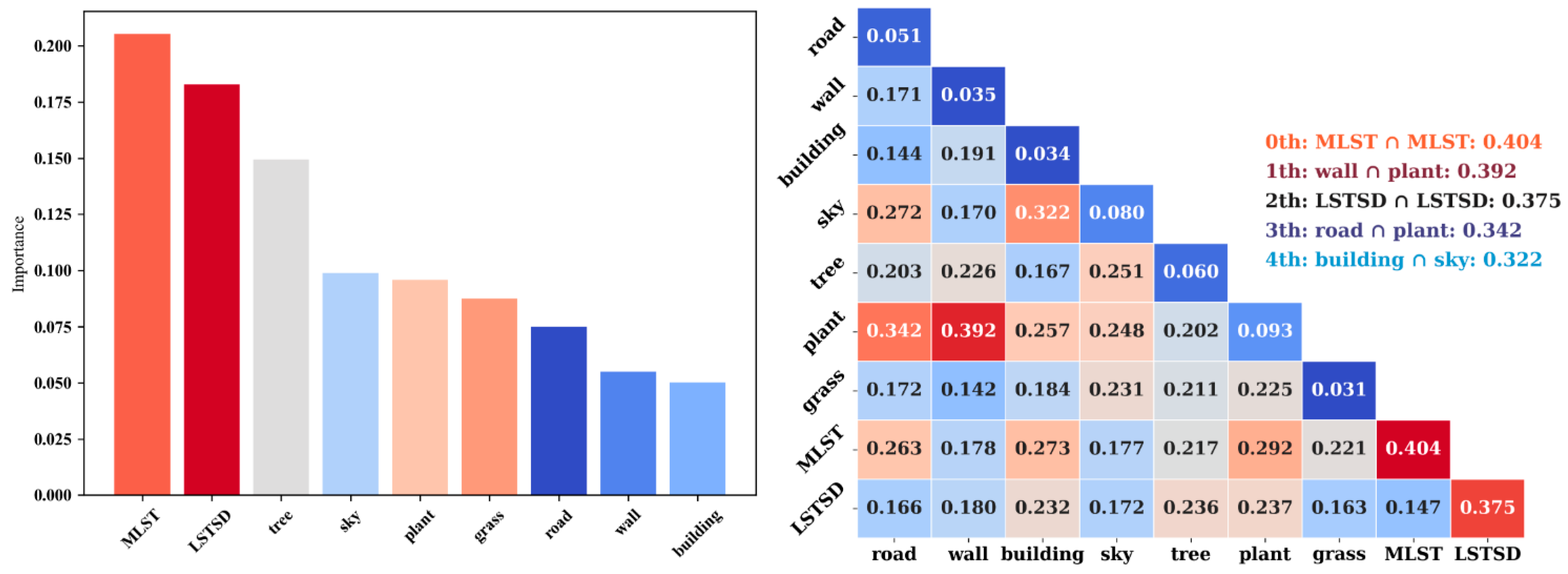
3.3. Effects of Streetscapes and Land Surface Temperatures on Cycling Behavior

A single-indicator analysis, employing the random forest (RF) model, played a pivotal role in evaluating feature importance, providing insights into the impact of individual features on output results. In this study, the metric characterizing cycling behavior was the number of cycling routes. By utilizing the feature importance assessment method within the RF regression model, as depicted in Figure 5, specific features with notably high importance were identified. All land surface temperature (LST) features exhibit an importance of 0.175 or higher, underscoring the crucial role of the thermal environment. Among the streetscape indicators, the four most important were vegetation and sky features, highlighting the importance of vegetation distribution and sky openness as primary environmental factors influencing residents’ choices of cycling routes. The elevated importance of these features suggests their vital roles in offering coolness, rest, and overall physical and mental enjoyment during cycling activities. Conversely, features such as buildings display relatively low importance, suggesting a lesser impact on cycling behavior. However, their widespread presence may limit residents’ route choices. This detailed analysis offers robust evidence supporting the optimization of the urban environment for promoting cycling, facilitating targeted interventions and improving a more cyclist-friendly urban landscape.
The interaction analysis employing the GeoDetector model, as depicted on the right side of Figure 5, sheds light on the nuanced relationships between various indicators. Particularly noteworthy is the discernible impact of streetscapes on the interplay with land surface temperature (LST) features, effectively mitigating LST influence on cycling behavior. This dynamic is especially pronounced in scenarios where the solitary effect of LST surpasses 0.375. However, during actual travel, the interaction with other streetscape elements leads to a reduction in this influence to over 0.3. Intriguingly, amidst high-temperature heatwaves, residents exhibit a diminished inclination toward bicycle usage. Yet, strategically designed and well-ventilated built-up areas counteract some of the adverse thermal effects, fostering a heightened propensity for bicycle travel.
When further dissecting the interactions within streetscapes, specific coefficients stand out, exemplified by the significant 0.392 coefficient between walls and shrubs. These interactions tend to manifest prominently in outer suburbs, characterized by favorable thermal conditions and abundant greenery, rendering them appealing for cycling enthusiasts. Moreover, the interactions involving roads and shrubs, buildings and the sky, and roads and the sky, wield substantial influence. The cycling behavior of residents is intricately linked to the maintenance of road conditions, and under optimal circumstances, a harmonious blend of sky openness and well-ventilated buildings emerges as the preferred choice for urban cycling enthusiasts.

4. Discussion

4.1. Climate Adaptation and Urban Planning Strategies Influence Cycling Behavior

This study explored the influence of streetscapes and LSTs on urban cycling behavior, and the results show that streetscape elements such as roads, walls, and buildings constitute a rich and diverse urban landscape [38], and the relationship between them becomes more complex in the context of the gradual deterioration of the urban thermal environment. To encourage cycling behavior, rational streetscape element design and planning and effective climate strategies are key controllable factors [39].
The results of the study show that streetscape design has a significant impact on cycling behavior. Streetscape design, such as vegetation planning, is a crucial aspect of urban planning and plays an important role in landscape design. Abundant greenery not only beautifies the urban environment but also provides fresh air and visual pleasure to cyclists, thus improving their overall experience [40,41]. Moderate shade and vegetation can also provide heat protection in hot weather, creating a more pleasant environment for cyclists [42]. Second, by providing turnouts and increasing the openness of streets, not only can the cycling atmosphere in the city increase, but it can also provide a richer experience for cyclists [43]. Moreover, the cyclists’ sense of identity with the city can be improved by designing architectural styles that harmonize with cycling. Relevant urban planning measures can help further deepen the understanding of the influence of streetscape design on cycling behavior and create a more suitable urban environment for cycling [44].
In addition, at middle and low latitudes, LST characteristics have a significant impact on cyclists’ travel [45]. Under summer high-temperature conditions, the LST may become the most important factor limiting cyclists’ activities, especially because cycling is a popular outdoor sport and cyclists are more likely to experience limitations due to the LSTs [46]. In addition, there is evidence that high urban temperatures may cause great harm to the comfort and physical health of residents [47,48], especially for cyclists, where heat stroke and dehydration are major problems. Therefore, there is a need for an in-depth study of how LST affects the behavior and health status of cyclists, which can be an important guide for providing appropriate guidance measures. For example, are people more inclined to choose early morning or evening cycling in hot weather? Is the increase in temperature related to cyclists’ travel preferences and route choices? Problem-oriented urban design leads to smarter and more humane urban transportation strategies. Overall, temperature, as an important climatic factor, is directly related to the travel experience of urban cyclists. In the context of high temperatures, e.g., the geometry of neighborhoods can change the momentum and mass and heat transfer around urban structures [49], which can have a significant impact on the outdoor environment of the city, and dense high-rise buildings can reconfigure the regional ventilation and thermal environment, jeopardizing the thermal safety of urban residents [50]. Research should pay more attention to the important impacts of LST on cycling behavior.

4.2. Analysis of Urban Planning and Policy Guidance

Urban planning strategies and climate conditions have a profound impact on the climate adaptability of urban cycling [51]. Among them, urban greening serves as an effective means to enhance the cycling environment. Through the rational planning of green spaces and vegetation, cities can not only effectively reduce the ambient temperature but also provide cyclists with fresher air, thereby comprehensively improving the cycling experience [52]. The incorporation of green spaces not only enhances the esthetics of the city but also provides residents with pleasant recreational areas, synergizing with cycling activities. Additionally, the scientific design of greenways and bike lanes not only creates safe and smooth pathways for cyclists but also elevates the livability of the city. This concept of segregating pedestrians and cyclists not only enhances cycling safety but also creates a more pleasant living environment for urban residents, encouraging more people to choose cycling as a mode of transportation [53].
Furthermore, the presence of water is another crucial factor influencing the climate adaptability of urban cycling. Water bodies not only add beauty to the city but also effectively regulate the surrounding temperature, providing cyclists with a cool cycling environment [54]. Therefore, the rational introduction of water bodies in urban planning can create a more pleasant cycling environment, enhancing the joy of cycling. For instance, the incorporation of artificial lakes, fountains, and other water features not only beautifies the cityscape but also offers citizens recreational spaces. Additionally, the installation of shading facilities is a key measure to improve the climate adaptability of urban cycling. Setting up rest stations and sunshades in the city [55] not only provides convenient rest areas for cyclists but also effectively alleviates discomfort during cycling in high-temperature weather. The comprehensive implementation of these measures will further drive the popularity and development of urban cycling, creating a more livable and cyclist-friendly urban environment for residents.
In summary, urban planning strategies and climatic conditions exert a considerable influence on the climate resilience of urban bicycling, with a specific emphasis on urban greening, street openness design, and shading facilities. The incorporation of green spaces and the development of dedicated bicycle infrastructure not only contribute to increased safety and convenience for cyclists but also elevate the overall quality of urban living.

4.3. Limitations and Future Avenues

The framework developed in this paper significantly enhances the fit compared to traditional linear models, effectively capturing the nonlinear effects of streetscapes and LST features on cycling behavior and analyzing scaling effects. However, certain limitations persist. For instance, the semantic segmentation accuracy and efficiency of street view images are anticipated to further increase with the ongoing development of deep learning technology. Additionally, while a mature machine learning model was used, the random forest model is continually evolving with the emergence of interpretable modules, such as SHAP, which is expected to provide a foundation for more in-depth analysis and interpretation of the model. Furthermore, potential errors in LST data due to various factors, such as sensor limitations, must be acknowledged [56]. Although these data help to provide insight into the spatial layout and relationships of LSTs, it is important to recognize that there are errors in the retrieval results. In future studies, continuous improvements can be made by combining data from multiple sources and additional scientific research methods.

5. Conclusions

The following main conclusions were drawn from this study:
(1) There is a significant urban heat island effect in the LST of the study area. High-density buildings and a large number of population activities exacerbated the heat island effect in the city center and certain areas in the east, with the highest LST reaching 46.93 °C. On the contrary, the greenery and water bodies in the northwest and northeast areas mitigated the LST, resulting in the lowest LST reaching 11.61 °C. The overall thermal environment of the study area is relatively poor.
(2) The contrasting experiments emphasized the importance of the 100 m buffer zone for the analysis, and the regression fit precision was almost always higher than 0.8 for multiple sets of contrasting experiments, confirming the important influence of streetscape and LST characteristics on cycling behavior.
(3) The results of the random forest (RF) model indicate that LST features and streetscape indicators (especially vegetation and sky features) play a pivotal role in influencing residents’ choice of cycling routes. Together with reasonable sky openness and open building ventilation, they become the preferred choice for cycling behavior.
(4) The GeoDetector model suggests that the interaction of greenery and good ventilation counteracts the negative impact of high-temperature heat waves on residents’ choice of cycling as a mode of transportation.
These findings highlight the importance of optimizing urban thermal environments and streetscapes to promote cycling behavior, and improving thermal environments and streetscapes through targeted interventions is expected to create urban patterns that are more conducive to cycling trips.

Author Contributions

Conceptualization, J.H.; methodology, H.X.; software, H.X.; validation, M.Q. and J.H.; writing—original draft preparation, M.Q. and J.H.; writing—review and editing, M.Q.; visualization, M.Q. and J.H.; supervision, J.H.; project administration, J.H.; funding acquisition, J.H. All authors have read and agreed to the published version of the manuscript.

Funding

The research was funded by “The annual project of the National Social Science Fund of China”, Research on the Practical Experience of Sports Promoting Ethnic Unity in Border Areas (project number: 22BTY020), the project of the Guangxi Philosophy and Social Science Fund of China, Strategies for the Activation of Ethnic Sports Villages and the Construction of Strong Sports Areas in the Hongshui River Basin (project number: 20BTY007), and the research project of vocational education reform in Guangxi, China, Internet+inter school alliance based vocational education Exploration and Practice of Promoting Ethnic Unity in Frontier Areas through Physical Education Curriculum (project number: GXGZJG2022B081).

Institutional Review Board Statement

Not applicable.

Informed Consent Statement

Not applicable.

Data Availability Statement

The results of the image data presented in this paper can be obtained upon request from the corresponding author. The cycling behavior data are accessible through the Lushu App, and access to the semantic segmentation results of street view images is restricted. Interested parties may obtain the restricted data by contacting the authors directly.

Conflicts of Interest

The authors declare no conflicts of interest.

References

  1. Managing the Risks of Extreme Events and Disasters to Advance Climate Change Adaptation: Special Report of the Intergovernmental Panel on Climate Change; Cambridge University Press: Cambridge, UK, 2012.
  2. AghaKouchak, A.; Chiang, F.; Huning, L.S.; Love, C.A.; Mallakpour, I.; Mazdiyasni, O.; Moftakhari, H.; Papalexiou, S.M.; Ragno, E.; Sadegh, M. Climate extremes and compound hazards in a warming world. Annu. Rev. Earth Planet. Sci. 2020, 48, 519–548. [Google Scholar] [CrossRef]
  3. Van Aalst, M.K. The impacts of climate change on the risk of natural disasters. Disasters 2006, 30, 5–18. [Google Scholar] [CrossRef] [PubMed]
  4. Pl⊘ger, J. Urban planning and urban life: Problems and challenges. Plan. Pract. Res. 2006, 21, 201–222. [Google Scholar] [CrossRef]
  5. Ann, T.W.; Wu, Y.; Zheng, B.; Zhang, X.; Shen, L. Identifying risk factors of urban-rural conflict in urbanization: A case of China. Habitat Int. 2014, 44, 177–185. [Google Scholar]
  6. Koren, H.S.; Butler, C.D. The interconnection between the built environment ecology and health. In Environmental Security and Environmental Management: The Role of Risk Assessment; Springer: Dordrecht, The Netherlands, 2006; pp. 111–125. [Google Scholar]
  7. Snep, R.P.H.; Clergeau, P. Biodiversity in cities, reconnecting humans with nature. In Sustainable Built Environments; Springer: Berlin/Heidelberg, Germany, 2020; pp. 251–274. [Google Scholar]
  8. Pucher, J.; Dijkstra, L. Promoting safe walking and cycling to improve public health: Lessons from the Netherlands and Germany. Am. J. Public Health 2003, 93, 1509–1516. [Google Scholar] [CrossRef]
  9. Biehl, A.; Ermagun, A.; Stathopoulos, A. Modelling determinants of walking and cycling adoption: A stage-of-change perspective. Transp. Res. Part F Traffic Psychol. Behav. 2018, 58, 452–470. [Google Scholar] [CrossRef]
  10. Shephard, R.J.; Johnson, N. Effects of physical activity upon the liver. Eur. J. Appl. Physiol. 2015, 115, 1–46. [Google Scholar] [CrossRef]
  11. Basso, J.C.; Suzuki, W.A. The effects of acute exercise on mood, cognition, neurophysiology, and neurochemical pathways: A review. Brain Plast. 2017, 2, 127–152. [Google Scholar] [CrossRef]
  12. Hötting, K.; Röder, B. Beneficial effects of physical exercise on neuroplasticity and cognition. Neurosci. Biobehav. Rev. 2013, 37, 2243–2257. [Google Scholar] [CrossRef]
  13. Hosie, M.P.; Sipos, M.; Britt, T.W. Maximizing Senior Leader Health and Wellbeing. 2023. Available online: https://apps.dtic.mil/sti/trecms/pdf/AD1201134.pdf (accessed on 19 September 2023).
  14. Mindell, J.S.; Cohen, J.M.; Watkins, S.; Tyler, N. Synergies between low-carbon and healthy transport policies. In Proceedings of the Institution of Civil Engineers-Transport; Thomas Telford Ltd.: London, UK, 2011; Volume 164, pp. 127–139. [Google Scholar]
  15. Zuurbier, M.; Hoek, G.; Oldenwening, M.; Lenters, V.; Meliefste, K.; Van Den Hazel, P.; Brunekreef, B. Commuters’ exposure to particulate matter air pollution is affected by mode of transport, fuel type, and route. Environ. Health Perspect. 2010, 118, 783–789. [Google Scholar] [CrossRef]
  16. Ferreira, M.C.; Costa, P.D.; Abrantes, D.; Hora, J.; Felício, S.; Coimbra, M.; Dias, T.G. Identifying the determinants and understanding their effect on the perception of safety, security, and comfort by pedestrians and cyclists: A systematic review. Transp. Res. Part F Traffic Psychol. Behav. 2022, 91, 136–163. [Google Scholar] [CrossRef]
  17. Lehner, M.; Mont, O.; Heiskanen, E. Nudging—A promising tool for sustainable consumption behaviour? J. Clean. Prod. 2016, 134, 166–177. [Google Scholar] [CrossRef]
  18. Van Acker, V.; Goodwin, P.; Witlox, F. Key research themes on travel behavior, lifestyle, and sustainable urban mobility. Int. J. Sustain. Transp. 2016, 10, 25–32. [Google Scholar] [CrossRef]
  19. Nieuwenhuijsen, M.J. Urban and transport planning pathways to carbon neutral, liveable and healthy cities; A review of the current evidence. Environ. Int. 2020, 140, 105661. [Google Scholar] [CrossRef]
  20. Lemieux, C.; Bichai, F.; Boisjoly, G. Synergy between green stormwater infrastructure and active mobility: A comprehensive literature review. Sustain. Cities Soc. 2023, 99, 104900. [Google Scholar] [CrossRef]
  21. Ogryzek, M.; Adamska-Kmieć, D.; Klimach, A. Sustainable transport: An efficient transportation network—Case study. Sustainability 2020, 12, 8274. [Google Scholar] [CrossRef]
  22. Gürçam, S. Paving the Way for Climate Resilience through Sustainable Urbanization: A Comparative Study. Lectio Soc. 2024, 8, 17–34. [Google Scholar] [CrossRef]
  23. Nawrath, M.; Kowarik, I.; Fischer, L.K. The influence of green streets on cycling behavior in European cities. Landsc. Urban Plan. 2019, 190, 103598. [Google Scholar] [CrossRef]
  24. Silvennoinen, K.C. Influence of Urban Design in the Choice of Transportation Mode-Cycling for a People-Centred Urban Form. Master’s Thesis, Utrecht University, Utrecht, The Netherlands, 2017. [Google Scholar]
  25. Nijen, N.P. The Influence of Infrastructure and Land Use Allocation on the Route Choice of Cyclists. Bachelor’s Thesis, University of Twente, Enschede, The Netherlands, 2022. [Google Scholar]
  26. Liu, S.; Long, Y.; Zhang, L.; Huang, Y. Urban high-quality navigation path planning that integrates human emotion perception learning. Trans. GIS 2023, 27, 2297–2319. [Google Scholar] [CrossRef]
  27. Rui, J.; Othengrafen, F. Examining the Role of Innovative Streets in Enhancing Urban Mobility and Livability for Sustainable Urban Transition: A Review. Sustainability 2023, 15, 5709. [Google Scholar] [CrossRef]
  28. Rogers, C.D.; Ting, M.; Li, C.; Kornhuber, K.; Coffel, E.D.; Horton, R.M.; Raymond, C.; Singh, D. Recent increases in exposure to extreme humid-heat events disproportionately affect populated regions. Geophys. Res. Lett. 2021, 48, e2021GL094183. [Google Scholar] [CrossRef]
  29. Sun, Q.C.; Macleod, T.; Both, A.; Hurley, J.; Butt, A.; Amati, M. A human-centred assessment framework to prioritise heat mitigation efforts for active travel at city scale. Sci. Total Environ. 2021, 763, 143033. [Google Scholar] [CrossRef]
  30. Deilami, K.; Rudner, J.; Butt, A.; MacLeod, T.; Williams, G.; Romeijn, H.; Amati, M. Allowing users to benefit from tree shading: Using a smartphone app to allow adaptive route planning during extreme heat. Forests 2020, 11, 998. [Google Scholar] [CrossRef]
  31. Rathore, M.M.; Shah, S.A.; Shukla, D.; Bentafat, E.; Bakiras, S. The role of ai, machine learning, and big data in digital twinning: A systematic literature review, challenges, and opportunities. IEEE Access 2021, 9, 32030–32052. [Google Scholar] [CrossRef]
  32. Raschka, S.; Patterson, J.; Nolet, C. Machine learning in python: Main developments and technology trends in data science, machine learning, and artificial intelligence. Information 2020, 11, 193. [Google Scholar] [CrossRef]
  33. Schonlau, M.; Zou, R.Y. The random forest algorithm for statistical learning. Stata J. 2020, 20, 3–29. [Google Scholar] [CrossRef]
  34. Ali, S.A.; Parvin, F.; Ahmad, A. Retrieval of land surface temperature from Landsat 8 OLI and TIRS: A comparative analysis between radiative transfer equation-based method and split-window algorithm. Remote Sens. Earth Syst. Sci. 2023, 6, 1–21. [Google Scholar] [CrossRef]
  35. Zhang, R.; Chen, J.; Feng, L.; Li, S.; Yang, W.; Guo, D. A refined pyramid scene parsing network for polarimetric SAR image semantic segmentation in agricultural areas. IEEE Geosci. Remote Sens. Lett. 2021, 19, 4014805. [Google Scholar] [CrossRef]
  36. Sun, H.; Xu, H.; He, H.; Wei, Q.; Yan, Y.; Chen, Z.; Li, X.; Zheng, J.; Li, T. A Spatial Analysis of Urban Streets under Deep Learning Based on Street View Imagery: Quantifying Perceptual and Elemental Perceptual Relationships. Sustainability 2023, 15, 14798. [Google Scholar] [CrossRef]
  37. Zhou, X.; Wen, H.; Zhang, Y.; Xu, J.; Zhang, W. Landslide susceptibility mapping using hybrid random forest with GeoDetector and RFE for factor optimization. Geosci. Front. 2021, 12, 101211. [Google Scholar] [CrossRef]
  38. Kim, J.H.; Lee, S.; Hipp, J.R.; Ki, D. Decoding urban landscapes: Google street view and measurement sensitivity. Comput. Environ. Urban Syst. 2021, 88, 101626. [Google Scholar] [CrossRef]
  39. Zhao, C.; Carstensen, T.A.; Nielsen, T.A.S.; Olafsson, A.S. Bicycle-friendly infrastructure planning in Beijing and Copenhagen-between adapting design solutions and learning local planning cultures. J. Transp. Geogr. 2018, 68, 149–159. [Google Scholar] [CrossRef]
  40. Addas, A. The importance of urban green spaces in the development of smart cities. Front. Environ. Sci. 2023, 11, 1206372. [Google Scholar] [CrossRef]
  41. Sen, S.; Guchhait, S.K. Urban green space in India: Perception of cultural ecosystem services and psychology of situatedness and connectedness. Ecol. Indic. 2021, 123, 107338. [Google Scholar] [CrossRef]
  42. Jay, O.; Capon, A.; Berry, P.; Broderick, C.; de Dear, R.; Havenith, G.; Honda, Y.; Kovats, R.S.; Ma, W.; Malik, A.; et al. Reducing the health effects of hot weather and heat extremes: From personal cooling strategies to green cities. Lancet 2021, 398, 709–724. [Google Scholar] [CrossRef]
  43. Ahn, B.; Friesenecker, M.; Kazepov, Y.; Brandl, J. How Context Matters: Challenges of Localizing Participatory Budgeting for Climate Change Adaptation in Vienna. Urban Plan. 2023, 8, 399–413. [Google Scholar] [CrossRef]
  44. Xiao, W.; Wei, Y.D. Assess the non-linear relationship between built environment and active travel around light-rail transit stations. Appl. Geogr. 2023, 151, 102862. [Google Scholar] [CrossRef]
  45. Meng, F.; Zheng, L.; Ding, T.; Wang, Z.; Zhang, Y.; Li, W. Understanding dockless bike-sharing spatiotemporal travel patterns: Evidence from ten cities in China. Comput. Environ. Urban Syst. 2023, 104, 102006. [Google Scholar] [CrossRef]
  46. Kesenheimer, J.S.; Sagioglou, C.; Kronbichler, A.; Gauckler, P.; Kolbinger, F.R. Why do people cycle (a lot)? A multivariate approach on mental health, personality traits and motivation as determinants for cycling ambition. J. Appl. Sport Psychol. 2023, 35, 1–21. [Google Scholar] [CrossRef]
  47. Yin, Z.; Liu, Z.; Liu, X.; Zheng, W.; Yin, L. Urban heat islands and their effects on thermal comfort in the US: New York and New Jersey. Ecol. Indic. 2023, 154, 110765. [Google Scholar] [CrossRef]
  48. Aghamolaei, R.; Azizi, M.M.; Aminzadeh, B.; O’donnell, J. A comprehensive review of outdoor thermal comfort in urban areas: Effective parameters and approaches. Energy Environ. 2023, 34, 2204–2227. [Google Scholar] [CrossRef]
  49. Mansouri, S.T.; Zarghami, E. Investigating the effect of the physical layout of the architecture of high-rise buildings, residential complexes, and urban heat islands. Energy Built Environ. 2023, in press. [Google Scholar] [CrossRef]
  50. Elliott, H.; Eon, C.; Breadsell, J.K. Improving City vitality through urban heat reduction with green infrastructure and design solutions: A systematic literature review. Buildings 2020, 10, 219. [Google Scholar] [CrossRef]
  51. Sharifi, A. Co-benefits and synergies between urban climate change mitigation and adaptation measures: A literature review. Sci. Total Environ. 2021, 750, 141642. [Google Scholar] [CrossRef]
  52. Nieuwenhuijsen, M.J. New urban models for more sustainable, liveable and healthier cities post COVID 19; reducing air pollution, noise and heat island effects and increasing green space and physical activity. Environ. Int. 2021, 157, 106850. [Google Scholar] [CrossRef]
  53. Pellegrini, P.; Baudry, S. Streets as new places to bring together both humans and plants: Examples from Paris and Montpellier (France). Soc. Cult. Geogr. 2014, 15, 871–900. [Google Scholar] [CrossRef]
  54. Shahmohamadi, P.; Che-Ani, A.; Etessam, I.; Maulud, K.; Tawil, N. Healthy environment: The need to mitigate urban heat island effects on human health. Procedia Eng. 2011, 20, 61–70. [Google Scholar] [CrossRef]
  55. Epelde, L.; Mendizabal, M.; Gutiérrez, L.; Artetxe, A.; Garbisu, C.; Feliu, E. Quantification of the environmental effectiveness of nature-based solutions for increasing the resilience of cities under climate change. Urban For. Urban Green. 2022, 67, 127433. [Google Scholar] [CrossRef]
  56. Sattari, F.; Hashim, M. A brief review of land surface temperature retrieval methods from thermal satellite sensors. Middle-East J. Sci. Res. 2014, 22, 757–768. [Google Scholar]
Figure 1. Research framework.
Sustainability 16 01990 g001
Figure 2. Study area and basic data.
Sustainability 16 01990 g002
Figure 3. Fitting accuracy of the LST retrieval results and comparison experiment.
Sustainability 16 01990 g003
Figure 4. Streetscape statistical results at the cycling-route scale.
Sustainability 16 01990 g004
Figure 5. RF model feature importance evaluation and GeoDetector model interaction analysis results.
Sustainability 16 01990 g005
Disclaimer/Publisher’s Note: The statements, opinions and data contained in all publications are solely those of the individual author(s) and contributor(s) and not of MDPI and/or the editor(s). MDPI and/or the editor(s) disclaim responsibility for any injury to people or property resulting from any ideas, methods, instructions or products referred to in the content.

