Article

Assessment of Ecotourism Environmental Carrying Capacity in the Qilian Mountains, Northwest China

Gansu Key Laboratory for Environmental Pollution Prediction and Control, College of Earth and Environmental Sciences, Lanzhou University, Lanzhou 730000, China
*
Author to whom correspondence should be addressed.
Sustainability 2024, 16(5), 1873; https://doi.org/10.3390/su16051873
Submission received: 20 January 2024 / Revised: 19 February 2024 / Accepted: 22 February 2024 / Published: 24 February 2024
(This article belongs to the Section Tourism, Culture, and Heritage)

Abstract

:
Ecotourism is the main trend of global tourism development, and evaluating the ecotourism environmental carrying capacity (EECC) of ecologically fragile areas can provide a scientific basis for the sustainable development of regional tourism. This study uses the typical fragile mountain area, the Qilian Mountains (QLMs), as an example and analyzes the spatial and temporal changes in EECC by constructing an evaluation indicator system of EECC, which is based on the framework of “natural ecological environment support—socio-economic pressure—tourism activity pressure”. In the results, it is found that the natural ecological environment support, socio-economic pressure, and tourism activity pressure in the QLMs all present a spatial distribution pattern of higher in the southeast and lower in the northwest. From a temporal perspective, most of the indicators of different subsystems show an increasing trend. The whole area of EECC in the QLMs shows an increasing trend in 85.4% of the region, while the EECC in some areas in the southeastern and northern parts shows a decreasing trend. Comparing different time periods, it is found that the EECC in the whole region shows an increasing trend from 2000 to 2010, while the proportion of areas with a decreasing trend in EECC from 2010 to 2018 reaches 67.1%. The research results can provide a scientific basis for the sustainable development of ecotourism in the QLMs and other similar regions in the world, and they further contribute to the protection of the ecological environment.

1. Introduction

Tourism has become an integral part of human life. With the rapid development of economic globalization and the rapid increase in low-cost tourism methods and visa-free regions, the number of international tourists has rapidly increased, further promoting the flourishing development of the tourism industry [1]. The development of the tourism industry not only brings huge economic benefits but also has a certain impact on the ecological environment of the places where tourism is developed, such as excessive consumption of natural resources, reduction in biodiversity, and destruction of ecosystems [2,3,4]. Therefore, how to combine the protection, enjoyment, and utilization of natural resources is an important practical problem faced by regions that have developed tourism industries. Ecotourism is a social and cultural activity that emphasizes the protection of natural ecological environments and can promote economic development in tourism destinations. It is a sustainable tourism development model [5]. From the perspective of tourism development, ecotourism is the fastest-growing segment of the world’s tourism industry, with an annual growth rate of 25–30%. Ecotourism has become a global trend in tourism [6].
The vigorous development of ecotourism is of great significance in promoting the sustainable development of regional ecosystems and socio-economics. Ecological carrying capacity (ECC), as a key benchmark for assessing the impact of human activities on the ecological environment, is being widely used in various types of regions to carry out ecological environment evaluation studies [7]. With the rapid development of ecotourism, the issue of ecotourism environmental carrying capacity (EECC) has gradually received widespread attention [8]. Especially for ecologically fragile regions, it is especially crucial and urgent to conduct research on the EECC. How to balance the relationship between tourism activity pressure and ecological protection in ecologically fragile areas has been the focus of attention. So far, EECC has been studied in terms of conceptual connotation, theoretical frameworks, measurement models, evaluation systems, and management applications, but they are all at the exploratory stage [9,10,11,12,13]. Synthesizing current research, the EECC can be defined as the threshold of tourism activity intensity that the natural, economic, and social environmental systems of a tourist destination can tolerate within a certain time and space range [8,10,12,13]. Essentially, it is a comprehensive reflection of the composition and structural characteristics of the tourism environmental system. Although scholars still have different definitions of its theoretical connotation, they have reached a consensus on protecting natural systems from destruction, measuring the threshold of destination carrying capacity, achieving sustainable economic and social development, and paying attention to tourist behavior and perception [10,11,13,14]. At present, there is no uniform standard for the evaluation index and method of EECC, and the evaluation needs to be adapted to local conditions [9]. Research on the EECC in ecologically fragile areas is mostly conducted through the construction of an indicator system and implemented using a comprehensive index method [13,15,16,17]. For example, Hu [18] takes Shanxi Province as an example to assess the EECC based on the entropy weight method. The EECC is a comprehensive indicator involving many factors, and the construction of its evaluation index system should cover three aspects: ecological environment changes, socio-economic development, and the pressure of tourism activities. However, most studies tend to oversimplify the construction of the EECC evaluation index system, often considering only one aspect such as ecological environmental changes or changes in tourism activities [13].
As an important ecological functional region in China, the Qilian Mountains (QLMs) serve as a natural ecological safety barrier between the Gobi Desert in the northwest and the Qinghai–Tibet Plateau, as well as being an important water conservation area and pastoral base. This region has unique natural landscapes and rich cultural resources, making it an ideal area for the development of tourism. In recent years, the rapid development of ecotourism has brought considerable economic benefits to the QLMs. However, the continuous increase in tourism activities has also placed a heavy burden on the ecosystem of the QLMs, causing serious pollution to the atmosphere, water, and soil, damage to vegetation, and a sharp decline in the number of wild animals. These issues are becoming increasingly prominent [19]. The increase in demand for ecotourism is a significant opportunity for the development of ecotourism in the Qilian Mountain National Park, while the contradiction between ecological environmental protection and tourism development poses a significant challenge [20,21]. Therefore, considering the rapid development of tourism activities in the QLMs and the pressing need for effective ecological protection, conducting an evaluation of the EECC becomes crucial. This evaluation serves as a fundamental measure to determine whether tourism activities exert negative impacts on the environment.
In view of this, this study integrates previous research findings and focuses on the overall consideration of sustainable tourism development in ecologically fragile areas, attempting to construct an evaluation indicator system for EECC from three aspects: natural, socio-economic, and tourism. This study evaluates the spatial characteristics of the EECC in the QLMs, aiming to provide a theoretical basis for the orderly development and rational layout of tourism resources in this region. The main research objectives of this article are as follows: (1) clarify the temporal and spatial change patterns within different subsystems; and (2) analyze the temporal and spatial variations in EECC. This study constructs an EECC evaluation indicator system from three dimensions, which enriches the theoretical framework of EECC and helps us to understand the connotation of EECC more comprehensively. In addition, this study provides referable methods and cases for EECC evaluation in other ecologically fragile areas, which helps in promoting the practical application of EECC evaluation.

2. Materials and Methods

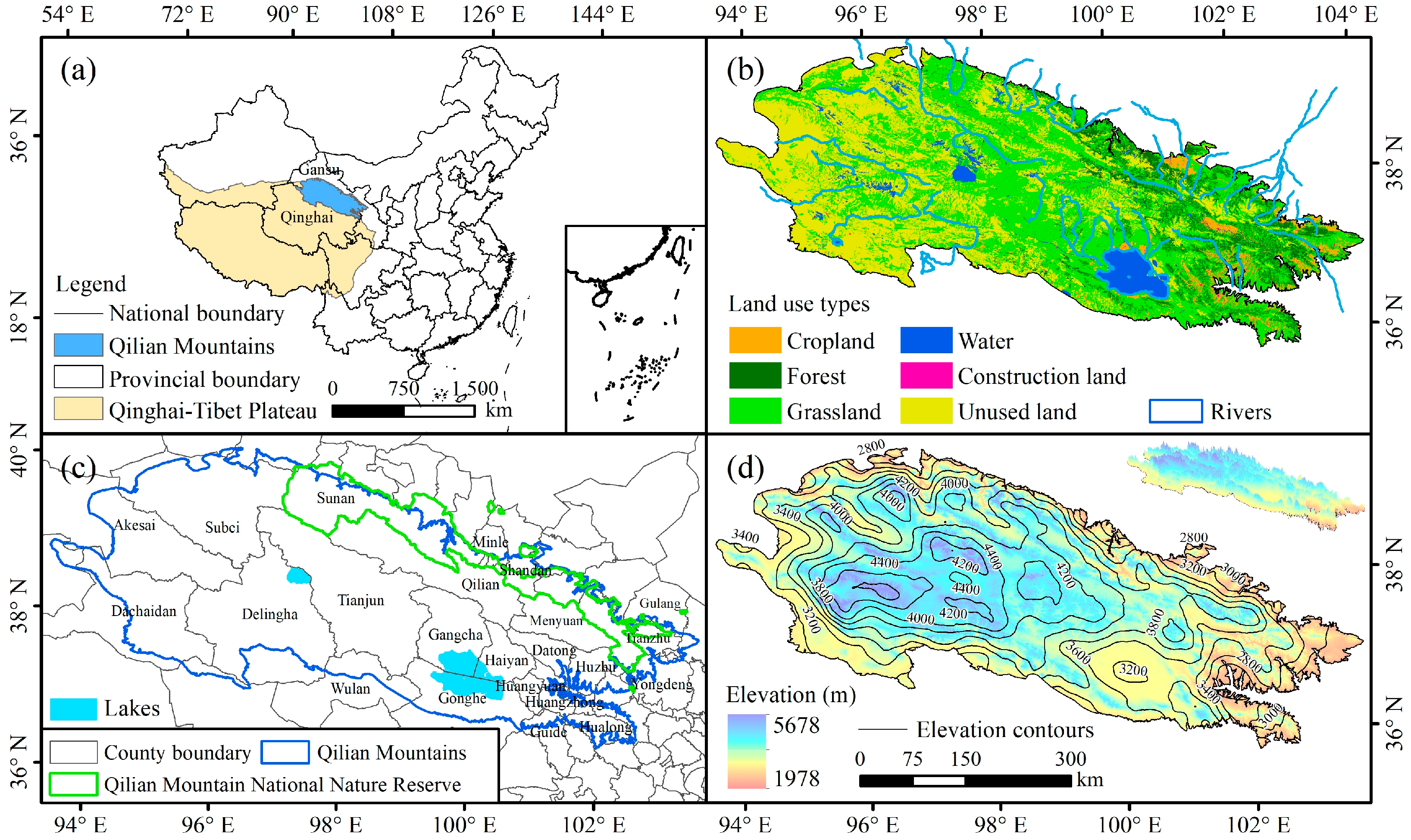
2.1. Overview of the Study Area

The QLMs are located in northwest China, specifically in the northeastern part of the Qinghai–Tibet Plateau (Figure 1a), and are a typical ecologically fragile area. The QLMs extend 800 km east–west and 200–400 km north–south, with an altitude ranging from 1978 to 5678 m and a topographic feature of high in the west and low in the east (Figure 1d). The climate of the QLMs has both continental and plateau characteristics, with significant differences in water and heat. The QLMs have mountains, lakes, streams, grasslands, and diverse wildlife populations (Figure 1a,d). These rich natural landscapes constitute unique tourism resources, attracting numerous domestic and foreign tourists for exploration and sightseeing. Since 2017, China has begun creating pilot projects for the Qilian Mountain National Park, promoting the development of tourism in the QLMs. However, while the abundant tourism resources bring economic benefits to the QLMs, they also increase pressure on ecological environmental protection [22].

2.2. Data Sources

2.2.1. Meteorological Data

The temperature and precipitation data on the monthly scale from 2000 to 2018 were obtained from the China Meteorological Administration Data Service Center (https://www.geodata.cn/, accessed on 16 January 2021). The dataset boasts a spatial resolution of 1 km × 1 km.

2.2.2. NDVI Data

The NDVI remote sensing image data from 2000 to 2018 in the study area were obtained from the MODIS vegetation index product MOD13A2 provided by NASA (https://www.nasa.gov/, accessed on 26 April 2021), with a spatial resolution of 1 km × 1 km and a temporal resolution of 16 days. In order to avoid the influence of uncertain factors such as clouds, atmosphere, and sun altitude, the Maximum Value Composite (MVC) method was used to process the two half-month NDVI products to obtain monthly NDVI data [23]. The remote sensing image data were processed based on ArcGIS 10.3 software, mainly including image cropping and synthesis.

2.2.3. Land Use Data

The land use data for 2000, 2010, and 2018 were obtained from the CN-LUCC dataset provided by the National Resources and Environment Database of the Chinese Academy of Sciences (https://www.resdc.cn/, accessed on 12 September 2021). The spatial resolution is 30 m × 30 m. This dataset is a thematic database of multi-temporal land use/land cover changes at the national scale in China, constructed through manual visual interpretation using Landsat remote sensing images from the United States as the main source of information. For consistency with the other datasets, the CN-LUCC data were resampled to a resolution of 1 km × 1 km.

2.2.4. Socio-Economic Data

The data on population density, GDP, proportion of the tertiary industry, number of schools, and the number of tourists from 2000 to 2018 were obtained from the Gansu Development Yearbook and the Qinghai Statistical Yearbook. Additionally, we accessed the data on the number of tourists from the China Statistical Yearbook for Regional Economy (https://www.cnki.net/, accessed on 23 September 2021).

2.3. Methods

2.3.1. Construction of Evaluation Indicator System for EECC

The construction of the EECC evaluation index system must follow the principles of scientificity, objectivity, operability, and ecological sustainability. Based on previous research results [2,14,18,24], this study constructed a three-level EECC evaluation indicator system based on the current situation of nature, socio-economic, and tourism development in the QLMs (Table 1). The first level is the objective layer; the second level is the standardized layer, including natural ecological environment support, socio-economic pressure, and tourism activity pressure; and the third level is the indicator layer, including 14 evaluation indicators. Specifically, the natural ecological environment usually includes aspects such as climate, vegetation, and ecological functions [18]. Therefore, we selected a total of six indicators to reflect this, of which temperature and precipitation reflect the climate condition, vegetation cover reflects the vegetation condition, biological richness index and water yield reflect the biodiversity and water conservation function, and landscape diversity reflects the landscape distribution condition in the region. Socio-economic pressure is usually reflected through economic growth, population size, industrial structure, social welfare, and resource consumption. Therefore, we selected GDP per capita, population density, percentage of tertiary sector, number of schools, total water consumption per unit area, and road network density as six indicators to reflect the socio-economic pressure situation in the QLMs. The number of tourists is one of the most direct indicators of tourism activity pressure in a region [18]. In addition, the number of tourist attractions is also directly related to tourism activity pressure. Therefore, this study mainly chose tourist density and number of tourist attractions to reflect the tourism activity pressure in the QLMs.

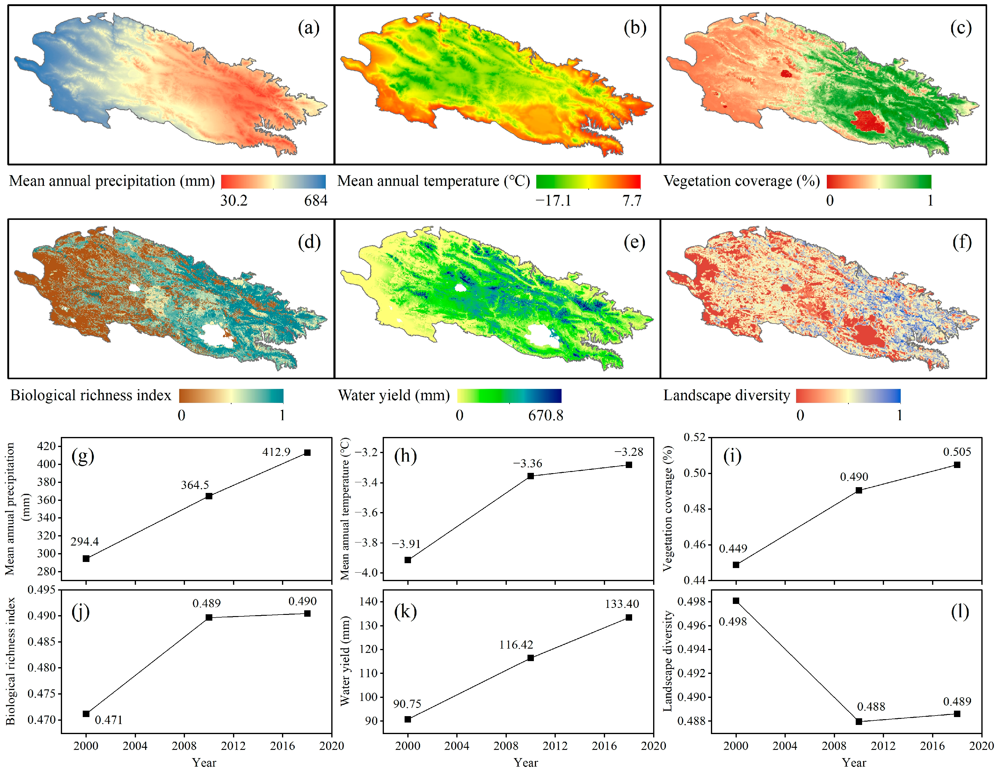
2.3.2. Calculation of Evaluation Indicators

Precipitation, temperature, population density, GDP per capita, percentage of tertiary sector, road network density, number of schools, total water consumption per unit area, tourist density, and number of tourist attractions can be directly obtained through data. The calculation process for the remaining indicators is as follows.
(1)
Vegetation coverage
Vegetation coverage (FVC) is an important indicator for measuring the condition of vegetation on the ground. FVC is defined as the percentage of the area of vegetation projected vertically on the ground, as a percentage of the total area of the statistical region. In this study, a dimidiate pixel model [25] was used to calculate FVC.
FVC = NDVI NDVI soil NDVI veg NDVI soil
where NDVI is the normalized vegetation index. NDVIsoil is the NDVI value of pure bare soil area. NDVIveg is the NDVI value of pure vegetation coverage. The NDVI values with cumulative frequencies of 5% and 95% are taken as NDVIsoil and NDVIveg.
(2)
Biological richness index
The biological richness index reflects the abundance and poverty of organisms in the region and is represented using the habitat quality index. The formula for calculating the habitat quality index is as follows [26]:
HQ = H j × 1 D xj z D xj z + k z
where HQ is the habitat quality of grid cell x in land use type (habitat type) j. Hj is the habitat suitability of land use type j. Dxj is the level of stress experienced by grid cell x in land use type (habitat type) j. k is a semi-saturation constant, usually taken to be half the maximum value of Dxj. z is a normalization constant, usually taken to be 2.5.
(3)
Water yield
Water yield can reflect the water source conservation function of the region. The calculation of water yield is carried out based on the water yield module of the InVEST model [26], which is established on the basis of Budyko’s water–heat coupling balance and annual average precipitation, while considering actual evapotranspiration. The formula is as follows:
Y xj = 1 AET xj P x × P x
where Yxj represents the water yield (mm) of the j-th land use type in grid cell x, AETxj is the annual actual evapotranspiration (mm) of the j-th land use type in grid cell x, and Px is the annual precipitation (mm) of grid cell x.
(4)
Landscape diversity
The Shannon–Weiner diversity index (SHDI) [27] is a type of landscape pattern index. This study used the SHDI to represent the landscape diversity index. The calculation of SHDI in 2000, 2010, and 2018 was implemented using the Fragstats v4.2.1 software.

2.3.3. Calculation of Indicator Weights

The entropy weight method has been widely applied in many fields, including oceanography, ecology, and tourism, due to its accuracy, comprehensiveness, and convenience [28]. It is an objective method for calculating indicator weights.
In this study, all grid cells in the study area were set as m samples, and 14 indicators such as precipitation were set as n indicators, forming an original data matrix xij (i = 1, 2, 3, …, m; j = 1, 2, 3, …, n).
(1)
Standardization of positive and negative indicators
Z ij = x ij min x ij max x ij min x ij
Z ij = max x ij x ij max x ij min x ij
where Zij is the standardized value, xij is the original value, and max(xij) and min(xij) are the maximum and minimum values.
(2)
Information entropy
P ij = Z ij i = 1 m Z ij
H j = 1 lnm i = 1 m P ij LnP ij
where Pij is the contribution degree of the j-th indicator. Hj is the entropy value of the j-th indicator.
(3)
Weights
W j = 1 H j j n H j
where Wj is the weight of the j-th indicator.

2.3.4. Calculation of EECC Based on the Comprehensive Indicator Method

This study used the comprehensive indicator method and GIS spatial analysis to evaluate the EECC of the QLMs. The comprehensive indicator method is based on calculating the weight of indicators and multiplying standardized data by their corresponding weights [18]. The formula is as follows:
F = j = 1 n W j Z ij
where Wj is the weight of each indicator. Zij is the standardized value of indicator j. F is the comprehensive score calculated based on the weights.

2.3.5. Classification of EECC Levels

The calculated EECC was normalized, and then the level of EECC was divided according to the equal division method [29] (Table 2).

3. Results

3.1. Variation Characteristics of Evaluation Indicators

3.1.1. Indicators of Natural Ecological Environment Support

To gain an understanding of the spatial distribution of each indicator, this study took the average of 2000, 2010, and 2018 data. It was observed that mean annual precipitation, vegetation coverage, biological richness index, and landscape diversity exhibited a pattern of higher values in the southeast and lower values in the northwest (Figure 2a,c,d,f). Furthermore, mean annual temperature peaks were predominantly found in low-altitude regions, with a gradual decrease in temperature as altitude increased (Figure 2b). The high values of water yield were primarily concentrated in the eastern part of the QLMs and the high-altitude regions in the west (Figure 2e). By analyzing the temporal changes in indicators of natural ecological environment support from 2000 to 2018, we found that precipitation, temperature, vegetation coverage, biological richness index, and water yield all showed an increasing trend (Figure 2g–k), while landscape diversity showed a decreasing trend (Figure 2l).

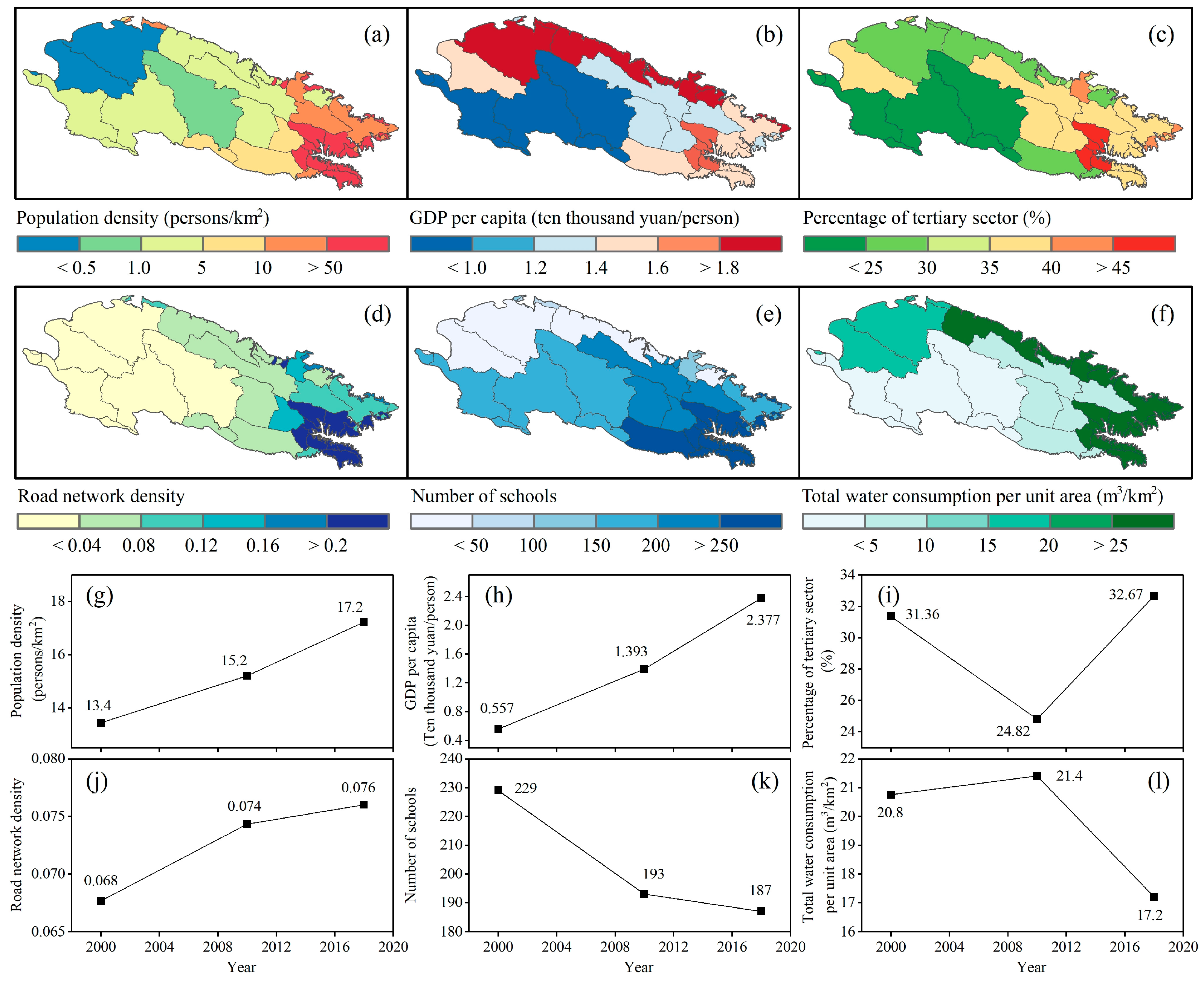
3.1.2. Indicators of Socio-Economic Pressure

From the perspective of socio-economic pressure indicators, population density, percentage of the tertiary sector, road network density, the number of schools, and total water consumption per unit area all showed a spatial distribution pattern with higher values in the southeast and lower values in the northwest (Figure 3a,c–f). In contrast, GDP per capita showed a different spatial distribution pattern with higher values in the north and southeast and lower values in the southwest (Figure 3b). In terms of temporal trends, population density, GDP per capita, and road network density all showed an upward trend from 2000 to 2018 (Figure 3g,h,j). However, the number of schools showed a decreasing trend, decreasing from 229 to 187 (Figure 3k). Additionally, the percentage of the tertiary sector showed a decreasing trend from 31.36% to 24.82% between 2000 and 2010, but it began to rebound after 2010 (Figure 3i). Notably, unlike the above indicators, total water consumption per unit area showed a slight increase from 20.8 to 21.4 m3/km2 between 2000 and 2010, but it began to rapidly decline after 2010, falling to 17.2 m3/km2 (Figure 3l).

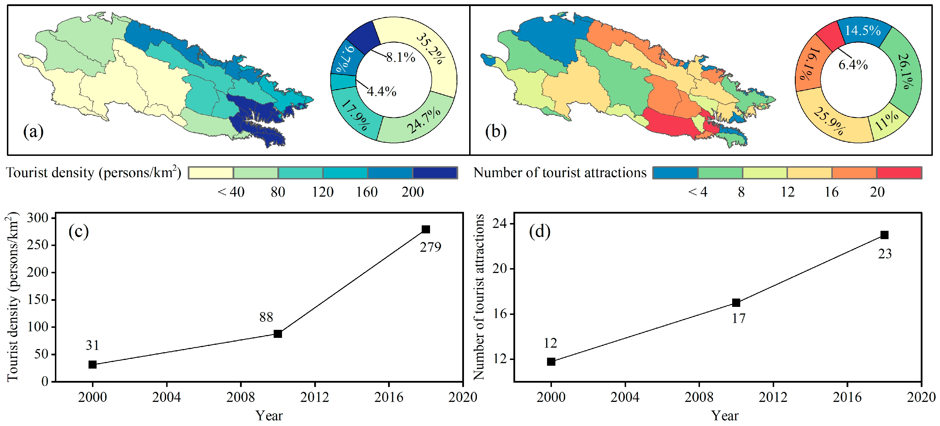
3.1.3. Indicators of Tourism Activity Pressure

The magnitude of tourism activity pressure was measured by two indicators: tourist density and the number of tourist attractions. The spatial distribution of these two indicators exhibited significant heterogeneity (Figure 4). The regions with higher tourist density mainly included the Sunan County located in the northern QLMs, as well as the Datong, Huzhu, Huangyuan, Huangzhong, and Hualong Counties in the southeast. However, the tourist density was relatively lower in the western Dachaidan, Delingha, and Tianjun counties (Figure 1c and Figure 4a). Overall, the number of tourist attractions exhibited a spatial distribution pattern with higher values in the southeast and lower values in the northwest. Specifically, there were more tourist attractions in the northern Sunan, Qilian, and Shandan counties, as well as in the southeastern Gonghe, Huangzhong, Gangcha, and Haiyan counties (Figure 4b). By calculating the temporal trends of tourism activity pressure indicators from 2000 to 2018, it was found that both tourist density and the number of tourist attractions in the QLMs increased from 2000 to 2018. Specifically, the tourist density increased from 31 persons/km2 in 2000 to 279 persons/km2 in 2018 (Figure 4c), and the number of tourist attractions increased from 12 in 2000 to 23 in 2018 (Figure 4d).

3.2. Variation Characteristics of Different Subsystems

In terms of spatial distribution, the natural ecological environment support in the eastern QLMs was relatively high, with a medium level in the central region and a relatively low level in the western region (Figure 5a–c). In terms of the spatial pattern of socio-economic pressure, the southeastern region also exhibited higher pressure, while the western region had relatively lower pressure (Figure 5d–f). Similarly, the southeastern and northern regions exhibited higher levels of tourism activity pressure, while the western region had relatively lower pressure. In terms of temporal trends, from 2000 to 2010, the proportion of areas with a medium level of natural ecological environment support increased (Figure 5a,b). The proportion of areas with different levels of socio-economic pressure did not change significantly from 2000 to 2010 (Figure 5d,e). However, from 2000 to 2018, the socio-economic pressure in the Huzhu and Huangyuan counties in the eastern region changed from a high level to a low level (Figure 1c and Figure 5e,f). At the same time, from 2000 to 2010, tourism activity pressure increased in some northern counties (Figure 5g,h). From 2000 to 2018, the tourism activity pressure in some southeastern counties changed from a lower level to a medium level (Figure 5h,i).

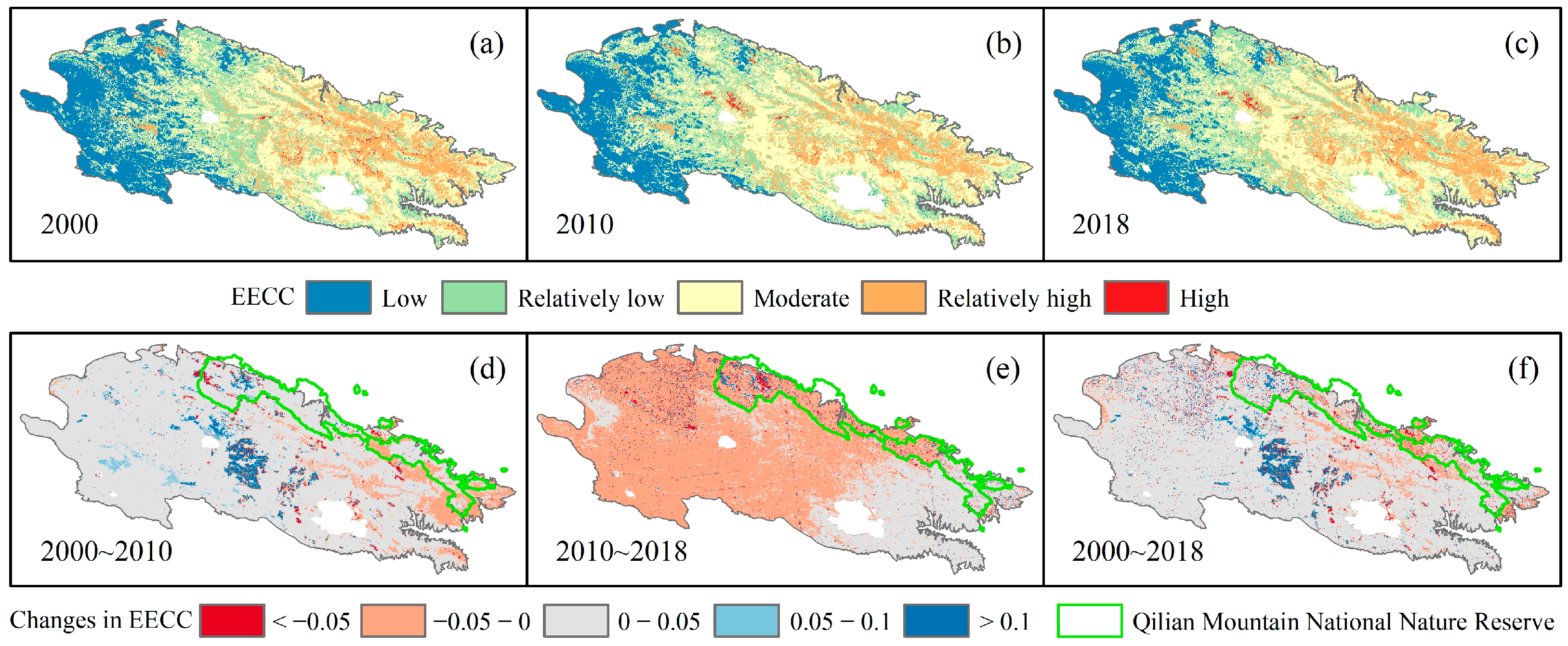
3.3. Variation Characteristics of EECC

This study evaluated the spatial distribution pattern of EECC in the QLMs. The results showed that the western part of the QLMs had low EECC, the central part showed a medium level, and the southeastern part showed a relatively high level (Figure 6a–c). Through comparison, it was found that its spatial pattern was basically consistent with the natural ecological environment support (Figure 5a–c). From different years, the area of different levels of EECC changed (Figure 6). In general, the area of medium-level EECC had the highest proportion. Specifically, from 2000 to 2010, the areas of low and relatively high EECC decreased, while the areas of relatively low and medium EECC increased; the area of high EECC remained unchanged. From 2010 to 2018, the areas of low, relatively high, and high levels of EECC increased, while the areas of relatively low and medium levels of EECC decreased.
The average EECC values across the entire QLMs were 0.408 in 2000, 0.429 in 2010, and 0.426 in 2018, indicating an initial increase followed by a decrease over time. Spatially, 85.4% of the study area exhibited a rising EECC trend from 2000 to 2018 (Figure 6f). When examining different timeframes, we observed that between 2000 and 2010, 87.4% of the region demonstrated an upward EECC trend (Figure 6d). Most of these increases ranged between 0 and 0.05 and were predominantly located in the western and central regions of the QLMs. Conversely, 12.6% of the areas, including parts of the southeast and north, saw a decrease in EECC, with the northern Qilian Mountain Nature Reserve exhibiting a particularly notable decline. During the 2010~2018 period, 67.1% of the regions showed a downward trend in EECC (Figure 6e), concentrated primarily in the west and center, while areas with increasing trends were mostly situated in the southeast. It is noteworthy that the downward trend in EECC is more pronounced in the northern part of the Qilian Mountains Nature Reserve.
In summary, whether from a temporal or spatial perspective, it can be found that EECC mainly increased from 2000 to 2010, while it mainly decreased from 2000 to 2018.

4. Discussion

4.1. Changes in Different Subsystems and Links between Them

This study evaluated three subsystems of EECC of the QLMs. Overall, the southeast region with higher natural ecological environment support has higher socio-economic pressures and tourism activity pressures (Figure 5), which is consistent with the findings of Duan et al. [22]. Natural ecological environment support is mainly influenced by three indicators: biological richness index, water yield, and landscape diversity, with their weights being 0.250, 0.243, and 0.185, respectively (Table 1). The southeast region of QLMs has higher natural ecological environment support than the northwest region (Figure 1b and Figure 5a–c), mainly due to the higher biological richness index and stronger water conservation function in the southeast region (Figure 2d,e) [30,31]. From the perspective of socio-economic pressure, the socio-economic pressure in the southeast counties was higher, mainly due to the higher population density, percentage of the tertiary sector, road network density, and number of schools in these regions (Figure 3a,c–e). Due to the good tourism resources in the southeast region, more tourist attractions have been built, attracting a large number of tourists, resulting in higher tourism activity pressure in this part of the region (Figure 4a,b and Figure 5i). From a temporal perspective, favorable climatic conditions of warmth and humidification have promoted the growth of vegetation and increased the water conservation function in this region, making the natural ecological environment continuously improve [32]. GDP per capita and the percentage of the tertiary sector are key factors in social and economic development (Table 1). In addition, transportation is also one of the factors for rapid economic growth [33]. With the continuous improvement in transportation facilities, especially in the southeast region, GDP has continued to grow rapidly [22]. Specifically, the improvement in the ecological environment and the continuous improvement in transportation facilities have attracted a large number of tourists (Figure 4a,b). The development of tourism in QLMs has driven rapid economic growth, but it has also caused some negative impacts on the ecological environment [22,32,34].

4.2. Causes of Changes in EECC

Since 2000, global tourism has continued to rise in popularity [4]. However, due to a focus on economic benefits, some ecotourism regions have ignored the protection of the ecological environment, not limiting the number of tourists, leading to overcrowded tourist peaks and causing a series of environmental issues, including garbage pollution, water pollution, air pollution, noise pollution, etc. [35,36]. This study found through the evaluation of EECC in QLMs that during the study period, EECC showed an overall increasing trend (Figure 6f). Reviewing previous studies, there are few direct analyses of EECC in the QLMs, but the results of this study can be verified by relevant studies. For example, Wang et al. [37] studied the tourism ecological security of the Qilian Mountains of the Zhangye section and found that since 2007, tourism ecological security has shown an overall increasing trend, which verifies the research results of this paper to a certain extent.
From the weight of the three subsystems, the natural ecological environment support is the most important indicator affecting EECC, which is consistent with previous studies [22,37]. Natural ecological environment support indicators, such as increased precipitation, vegetation coverage, and biological richness index, have gradually improved the ecological environment, leading to an increasing trend in EECC (Figure 2a,c,d and Figure 3c) [32]. However, we also observed that from 2000 to 2018, there were still some regions where EECC showed a decreasing trend, mainly including the nature reserves in the northern QLMs and some regions in the central part (Figure 6f). This was mainly due to the increase in socio-economic pressure and tourism activity pressure indicators (Figure 3 and Figure 4) [20]. As the ecological environment improved, it attracted a large number of tourists to visit the QLMs, leading to an increasing density of tourist visitors (Figure 4c,d) [38]. The continuous increase in tourism activity pressure has led to a decrease in EECC in some local areas. Li et al. [32] also found that the development of tourism in Qilian Mountain National Nature Reserve has affected the vegetation communities in the tourism area. The development of tourism has increased human disturbance through infrastructure construction [32]. Specifically, the development of tourism has created more infrastructure, more illegal housing, tourist service centers, parking lots, and other facilities that may affect the ecological environment. Spatially, the density of tourist attractions in nature reserves was also relatively high (Figure 4b). This is also one of the reasons for the decrease in EECC in this region. Additionally, the increase in socio-economic activities has also contributed to the decrease in EECC. Indicators of socio-economic pressure in the QLMs, such as road network density and the percentage of the tertiary sector, contribute positively to the decrease in EECC.
For different regions with different EECC levels, corresponding tourism management policies can be implemented. For example, in areas with low and relatively low EECC levels, ecological restoration can be carried out through policies such as limiting the number of tourists and establishing protected areas [11]. However, in areas with high levels of EECC, tourism facilities and services can be increased appropriately, and related tourism products and activities can be promoted to attract more tourists to visit and promote tourism. In the future management of tourism projects in the QLMs, appropriate flexibility can be achieved through the implementation of peak and off-peak seasons. Especially during the off-peak season, control measures can be implemented to repair the ecological environment and mitigate the impact of human activities on the ecological environment during the peak season. Additionally, certain environmental protection systems should be adopted to promptly dispose of waste in scenic areas and scientifically and efficiently guide the sustainable development of tourism in the QLMs. In short, the natural environment can lead to the development of the tertiary industry, which will increase the income of the residents of different tourist counties in the QLMs. However, with the increase in tourist density and tourist attractions, there will be negative impacts on the carrying capacity of the ecological environment, such as a decrease in the number of schools and landscape diversity. Therefore, there is a need to develop tourism on the basis of protecting the ecological environment and promoting harmonious coexistence between human beings and nature. The development of tourism resources in ecologically sound areas will not have much impact on the EECC; therefore, in the process of tourism management, managers should first assess the EECC so as to formulate tourism development policies to avoid negative impacts on the EECC due to overdevelopment [39,40].

4.3. Uncertainties and Future Work

This study constructed an EECC evaluation index system from the three dimensions of natural ecological environment support–socio-economic pressure–tourism activity pressure and analyzed the spatial and temporal changes in EECC in the QLMs (Figure 6), which is of great significance for achieving sustainable development in the QLMs. However, there are some shortcomings in this study. First, the results of the EECC evaluation are a theoretical value that has not been field-validated, which adds a degree of uncertainty to its assessment results. Field validation of the EECC is needed in the future [41]. Second, natural factors and human activities often interact and jointly affect regional ecological environment changes [42]. In the future, the drivers of EECC should be explored in depth, the interactions between different factors should be clarified, and the underlying causes of changes in EECC should be revealed. Finally, the spatial resolution of this study is 1 km × 1 km; further research should further improve the spatial resolution and accuracy of the data and extend the time series. In addition, the future development trend of the EECC in the QLMs needs to be predicted using appropriate models and methods to more fully grasp the pattern of its development and evolution.

5. Conclusions

This study took the QLMs as an example, constructed an evaluation indicator system for the EECC suitable for fragile mountain areas, and evaluated the temporal and spatial change characteristics of EECC in the QLMs. The results showed that the natural ecological environment support, socio-economic pressure, and tourism activity pressure in the QLMs all presented a spatial distribution pattern of high in the southeast and low in the northwest. Similarly, the EECC was higher in the southeast, while it was lower in the northwest. The change in EECC was mainly affected by natural ecological environment support indicators, but it was also controlled by socio-economic pressure and tourism pressure indicators. The increase in EECC from 2000 to 2018 was mainly related to the increase in precipitation, biological richness index, and water yield. The decrease in EECC in the northern nature reserve of the QLMs was mainly related to tourism activities. The results of this study could provide a reference for the study of tourism carrying capacity in other similar regions around the world. In the future, it is necessary to continue to explore evaluation indicator systems for EECC suitable for various fragile ecological areas, compare and analyze different regions, and explore the inherent mechanism of EECC changes.

Author Contributions

Conceptualization, Q.D.; methodology, Q.D. and Y.S.; software, Q.W.; formal analysis, Q.D.; investigation, Q.W.; writing—original draft preparation, Q.D. and Y.S.; writing—review and editing, Q.D. and Q.G.; funding acquisition, Q.G. and Q.D. All authors have read and agreed to the published version of the manuscript.

Funding

This research was funded by National Key Research and Development Program of China (Grant no. 2019YFC0507402) and the Fundamental Research Funds for the Central Universities (Grant no. lzujbky-2022-it08).

Institutional Review Board Statement

Not applicable.

Informed Consent Statement

Informed consent was obtained from all research subjects.

Data Availability Statement

The data presented in this study are available on request from the first author.

Conflicts of Interest

The authors declare no conflicts of interest.

References

  1. Asadpourian, Z.; Rahimian, M.; Gholamrezai, S. SWOT-AHP-TOWS analysis for sustainable ecotourism development in the best area in Lorestan Province, Iran. Soc. Indic. Res. 2020, 152, 289–315. [Google Scholar] [CrossRef]
  2. He, H.; Shen, L.; Wong, S.W.; Cheng, G.; Shu, T. A “load-carrier” perspective approach for assessing tourism resource carrying capacity. Tour. Manag. 2023, 94, 104651. [Google Scholar] [CrossRef]
  3. Grimes, S.; Bouchair, A.; Tebbouche, H. Sustainability of the Expansion Areas for Coastal Touristic Sites “EACTS” Such as the case of El-Aouana in Algeria: Indicators for considering biodiversity. Energy Procedia 2017, 119, 170–181. [Google Scholar] [CrossRef]
  4. Streimikiene, D.; Svagzdiene, B.; Jasinskas, E.; Simanavicius, A. Sustainable tourism development and competitiveness: The systematic literature review. Sustain. Dev. 2021, 29, 259–271. [Google Scholar] [CrossRef]
  5. Stronza, A.L.; Hunt, C.A.; Fitzgerald, L.A. Ecotourism for conservation? Annu. Rev. Environ. Resour. 2019, 44, 229–253. [Google Scholar] [CrossRef]
  6. Singh, T.; Slotkin, M.H.; Vamosi, A.R. Attitude towards ecotourism and environmental advocacy: Profiling the dimensions of sustainability. J. Vacat. Mark. 2007, 13, 119–134. [Google Scholar] [CrossRef]
  7. Wackernagel, M.; Rees, W. Our Ecological Footprint: Reducing Human Impact on the Earth; New Society Publishers: Gabriola, BC, Canada, 1998; Volume 9. [Google Scholar]
  8. Salemi, M.; Jozi, S.A.; Malmasi, S.; Rezaian, S. A new model of ecological carrying capacity for developing ecotourism in the protected area of the north karkheh, Iran. J. Indian Soc. Remote Sens. 2019, 47, 1937–1947. [Google Scholar] [CrossRef]
  9. Li, J.; Weng, G.; Pan, Y.; Li, C.; Wang, N. A scientometric review of tourism carrying capacity research: Cooperation, hotspots, and prospect. J. Clean. Prod. 2021, 325, 129278. [Google Scholar] [CrossRef]
  10. Li, Y.H.; Xiang, B. Research Progress in the Ecotourism Environmental Carrying Capacity. Adv. Mater. Res. 2014, 869, 781–785. [Google Scholar] [CrossRef]
  11. Lu, J.; Chen, H. Dynamic Evaluation and Forecasting Analysis of Touristic Ecological Carrying Capacity of Forest Parks in China. Forests 2023, 15, 38. [Google Scholar] [CrossRef]
  12. Wulandari, A.; Maryono, M.; Setyawan, A. Carrying capacity for ecotourism development in Tahura KGPAA Mangkunagoro I. In E3S Web of Conferences; EDP Sciences: Les Ulis, France, 2018; Volume 73, p. 02007. [Google Scholar]
  13. Yu, K.; Gao, H. Sustainable development, eco-tourism carrying capacity and fuzzy algorithm-a study on Kanas in Belt and Road. Sci. Rep. 2023, 13, 16789. [Google Scholar] [CrossRef] [PubMed]
  14. Shi, L.; Zhao, H.; Li, Y.; Ma, H.; Yang, S.; Wang, H. Evaluation of Shangri-La County’s tourism resources and ecotourism carrying capacity. Int. J. Sustain. Dev. World Ecol. 2015, 22, 103–109. [Google Scholar] [CrossRef]
  15. Chen, H.S.; Chen, C.Y.; Chang, C.T.; Hsieh, T. The construction and application of a carrying capacity evaluation model in a national park. Stoch. Environ. Res. Risk Assess. 2014, 28, 1333–1341. [Google Scholar] [CrossRef]
  16. Leka, A.; Lagarias, A.; Panagiotopoulou, M.; Stratigea, A. Development of a Tourism Carrying Capacity Index (TCCI) for sustainable management of coastal areas in Mediterranean islands–Case study Naxos, Greece. Ocean Coast. Manag. 2022, 216, 105978. [Google Scholar] [CrossRef]
  17. Xiang, B.H.; Zeng, Y.X. Ecotourism construction and operating mechanism in the Sanjiangyuan National Park System Pilot Area, China. Resour. Sci. 2017, 39, 50–60. (In Chinese) [Google Scholar]
  18. Hu, G. Study on the temporal and spatial differences of ecotourism environmental carrying capacity in Shanxi Province. For. Econ. 2019, 41, 110–115. (In Chinese) [Google Scholar]
  19. Huang, B.R.; Ma, Y.H.; Huang, K.; Su, L.Y.; Zhang, C.L.; Cheng, D.W.; Wang, Y. Strategic Approach on Promoting Reform of China’s Natural Protected Areas System with National Parks as Backbone. Bull. Chin. Acad. Sci. 2018, 33, 1342–1351. (In Chinese) [Google Scholar]
  20. Ma, L.; Zhu, Z.; Li, S.; Li, J. Analysis of spatial and temporal changes in human interference in important ecological function areas in China: The Gansu section of Qilian Mountain National Park as an example. Environ. Monit. Assess. 2023, 195, 1029. [Google Scholar] [CrossRef]
  21. Ren, B.; Park, K.; Shrestha, A.; Yang, J.; McHale, M.; Bai, W.; Wang, G. Impact of Human Disturbances on the Spatial Heterogeneity of Landscape Fragmentation in Qilian Mountain National Park, China. Land 2022, 11, 2087. [Google Scholar] [CrossRef]
  22. Duan, Q.; Luo, L.; Zhao, W.; Zhuang, Y.; Liu, F. Mapping and evaluating human pressure changes in the Qilian mountains. Remote Sens. 2021, 13, 2400. [Google Scholar] [CrossRef]
  23. Holben, B.N. Characteristics of maximum-value composite images from temporal AVHRR data. Int. J. Remote Sens. 1986, 7, 1417–1434. [Google Scholar] [CrossRef]
  24. Wang, J.; Huang, X.; Gong, Z.; Cao, K. Dynamic assessment of tourism carrying capacity and its impacts on tourism economic growth in urban tourism destinations in China. J. Destin. Mark. Manage. 2020, 15, 100383. [Google Scholar] [CrossRef]
  25. Carlson, T.N.; Ripley, D.A. On the relation between NDVI, fractional vegetation cover, and leaf area index. Remote Sens. Environ. 1997, 62, 241–252. [Google Scholar] [CrossRef]
  26. Tallis, H.T.; Ricketts, T.; Guerry, A.D.; Wood, S.A.; Sharp, R.; Nelson, E.; Ennaanay, D.; Wolny, S.; Olwero, N.; Vigerstol, K.; et al. Integrated Valuation of Environmental Services and Tradeoffs (InVEST) 3.1. 0 User’s Guide; Natural Capital Project: Washington, DC, USA, 2014. [Google Scholar]
  27. Listopad, C.M.; Masters, R.E.; Drake, J.; Weishampel, J.; Branquinho, C. Structural diversity indices based on airborne LiDAR as ecological indicators for managing highly dynamic landscapes. Ecol. Indic. 2015, 57, 268–279. [Google Scholar] [CrossRef]
  28. Shemshadi, A.; Shirazi, H.; Toreihi, M.; Tarokh, M.J. A fuzzy VIKOR method for supplier selection based on entropy measure for objective weighting. Expert Syst. Appl. 2011, 38, 12160–12167. [Google Scholar] [CrossRef]
  29. Wu, T.; Sang, S.; Wang, S.; Yang, Y.; Li, M. Remote sensing assessment and spatiotemporal variations analysis of ecological carrying capacity in the Aral Sea Basin. Sci. Total Environ. 2020, 735, 139562. [Google Scholar] [CrossRef] [PubMed]
  30. Ma, X.; Zhang, H. Land-Use/Land-Cover Change and Ecosystem Service Provision in Qinghai Province, China: From the Perspective of Five Ecological Function Zones. Land 2023, 12, 656. [Google Scholar] [CrossRef]
  31. Wang, X.; Zhu, J.; Peng, S.; Zheng, T.; Qi, Z.; Hu, J.; Ji, C. Patterns of grassland community composition and structure along an elevational gradient on the Qinghai–Tibet Plateau. J. Plant Ecol. 2022, 15, 808–817. [Google Scholar] [CrossRef]
  32. Li, Z.X.; Feng, Q.; Li, Z.J.; Wang, X.F.; Gui, J.; Zhang, B.; Li, Y.C.; Deng, X.H.; Jian, X.; Gao, W.D.; et al. Reversing conflict between humans and the environment-The experience in the Qilian Mountains. Renew. Sustain. Energy Rev. 2021, 148, 111333. [Google Scholar] [CrossRef]
  33. Litman, T. Evaluating Transportation Economic Development Impacts; Victoria Transport Policy Institute: Victoria, BC, Canada, 2017. [Google Scholar]
  34. Yin, F.; Deng, X.; Jin, Q.; Yuan, Y.; Zhao, C. The impacts of climate change and human activities on grassland productivity in Qinghai Province, China. Front. Earth Sci. 2014, 8, 93–103. [Google Scholar] [CrossRef]
  35. Ruan, W.; Li, Y.; Zhang, S.; Liu, C.H. Evaluation and drive mechanism of tourism ecological security based on the DPSIR-DEA model. Tour. Manag. 2019, 75, 609–625. [Google Scholar] [CrossRef]
  36. Zekan, B.; Weismayer, C.; Gunter, U.; Schuh, B.; Sedlacek, S. Regional sustainability and tourism carrying capacities. J. Clean. Prod. 2022, 339, 130624. [Google Scholar] [CrossRef]
  37. Wang, Y.; Wu, C.; Wang, F.; Sun, Q.; Wang, X.; Guo, S. Comprehensive evaluation and prediction of tourism ecological security in droughty area national parks—A case study of Qilian Mountain of Zhangye section, China. Environ. Sci. Pollut. Res. 2021, 28, 16816–16829. [Google Scholar] [CrossRef]
  38. Pu, L.; Lu, C.; Yang, X.; Chen, X. Spatio-Temporal Variation of the Ecosystem Service Value in Qilian Mountain National Park (Gansu Area) Based on Land Use. Land 2023, 12, 201. [Google Scholar] [CrossRef]
  39. Jiang, G.Y.; Zhuo, M.C. Environment carrying capacity of eco-tourism at county levels in the south of the Qinghai-Tibet Plateau. J. Arid Land Resour. Environ. 2014, 28, 202–208. (In Chinese) [Google Scholar]
  40. Zhi, L.H.; Zhang, Z.; Bai, J.H.; Li, X.W. Research on the carrying capacity of tourism environment in the yellow river delta. Environ. Eng. 2023, 41, 132–140, 163. (In Chinese) [Google Scholar]
  41. Shan, S.Y.; Xu, H.J.; Qi, X.L.; Chen, T.; Wang, X.D. Evaluation and prediction of ecological carrying capacity in the Qilian Mountain National Park, China. J. Environ. Manag. 2023, 339, 117856. [Google Scholar] [CrossRef] [PubMed]
  42. Guo, B.; Liu, Y.; Fan, J.; Lu, M.; Zang, W.; Liu, C.; Wang, B.; Huang, X.; Lai, J.; Wu, H. The salinization process and its response to the combined processes of climate change–human activity in the Yellow River Delta between 1984 and 2022. Catena 2023, 231, 107301. [Google Scholar] [CrossRef]
Figure 1. Overview map of the study area. (a) Location of the QLMs in China. (b) Land use types and rivers of the QLMs. (c) Spatial distribution of different counties and Qilian Mountain National Nature Reserve in the QLMs. (d) Spatial distribution of elevations and elevation contours (The top-right corner is a three-dimensional map of the spatial distribution of elevation).
Sustainability 16 01873 g001
Figure 2. Spatial and temporal variation characteristics of the indicators of natural ecological environment support ((af) represent the spatial distribution of mean annual precipitation, mean annual temperature, vegetation coverage, biological richness index, water yield, and landscape diversity; (gl) represent the temporal variation of mean annual precipitation, mean annual temperature, vegetation coverage, biological richness index, water yield, and landscape diversity).
Sustainability 16 01873 g002
Figure 3. Spatial and temporal variation characteristics of the indicators of socio-economic pressure ((af) represent the spatial distribution of population density, GDP per capita, percentage of the tertiary sector, road network density, the number of schools, and total water consumption per unit area; (gl) represent population density, GDP per capita, percentage of the tertiary sector, road network density, the number of schools, and total water consumption per unit area).
Sustainability 16 01873 g003
Figure 4. Spatial and temporal variation characteristics of the indicators of tourism activity pressure ((a,b) represent the spatial distribution of tourist density and the number of tourist attractions; (c,d) represent the temporal variation of tourist density and the number of tourist attractions).
Sustainability 16 01873 g004
Figure 5. Spatial distribution pattern of three subsystems in different years. ((ac): natural ecological environment support; (df): socio-economic pressure; (gi): tourism activity pressure.)
Sustainability 16 01873 g005
Figure 6. Spatial distribution of EECC (ac) and its changes (df) in different years.
Sustainability 16 01873 g006
Table 1. Evaluation indicator system for EECC.
Objective LayerStandardized LayerIndicator LayerPropertiesWeights
Ecotourism environmental carrying capacityNatural ecological environment supportPrecipitationPositive0.064
TemperaturePositive0.025
Vegetation coveragePositive0.056
Biological richness indexPositive0.250
Water yieldPositive0.243
Landscape diversityPositive0.185
Socio-economic pressurePopulation densityNegative0.0002
GDP per capitaNegative0.006
Percentage of tertiary sectorNegative0.045
Road network densityNegative0.0002
Number of schoolsNegative0.032
Total water consumption per unit areaNegative0.024
Tourism activityTourist densityNegative0.015
Number of tourist attractionsNegative0.052
Table 2. Levels of EECC.
EECC values0–0.20.2–0.40.4–0.60.6–0.80.8–1.0
EECC levelsLow EECCRelatively low EECCModerate EECCRelatively high EECCHigh EECC
Disclaimer/Publisher’s Note: The statements, opinions and data contained in all publications are solely those of the individual author(s) and contributor(s) and not of MDPI and/or the editor(s). MDPI and/or the editor(s) disclaim responsibility for any injury to people or property resulting from any ideas, methods, instructions or products referred to in the content.

