1. Introduction
On the one hand, a smart city (SC) is a highly popular idea as a solution to rapid urbanization challenges [
1]. On the other, it still remains surprisingly separated from the physical structure and urban form of the city. The SC idea seems to be understood predominantly either as a technological concept based on the implementation of information and communication technologies (ICTs) [
2,
3,
4,
5,
6,
7] or as a variety of methods for managing or governing a city as an entity or its given elements, e.g., resources, traffic, and inhabitants [
8,
9,
10,
11,
12,
13,
14]. Furthermore, an SC’s association with urban form is mostly reduced to GIS data analysis [
15]. An SC may appear to be an amorphous concept [
16]. However, the need to take urban design and form into consideration is being noted increasingly often [
17,
18,
19,
20]. In acknowledgement of the interrelation between an SC and its urban form, the need to define a smart urban form’s (SUF) components emerges as a pressing issue.
This paper continues research into the correlation of urban form and an SC as a concept presented in a PhD thesis by Gorgol [
21]. The previous study found a strong correlation between an SC and its urban form. It was found that certain urban form components add up to a smart urban form and include blue–green infrastructure which plays a key role. In addition, an SC’s resilience appeared to be strongly connected and dependent on its urban form. This paper fills a gap in research on the physical structure of an SC with a particular focus on blue–green infrastructure. The hypothesis of the study is that an SUF is a guarantor of a resilient SC. In a more detailed perspective, in terms of blue–green infrastructure, the assumption is that creating a SUF should be goal-oriented in order to provide high spatio-functional quality of a space.
This paper is organized into six sections. The introduction focuses on the problematization and the research aims.
Section 2 presents the research methodology and the cases.
Section 3 includes the results of the literature review—the recent state-of-the-art in terms of the SC–urban form correlation. It also proposes a framework for the SUF as a term. The results are presented in
Section 4 (to keep the paper short, two existing SC districts: the Songdo International Business District—the Songdo IBD—in South Korea and Aspern Seestadt in Vienna, Austria, were focused on).
Section 5 features the discussion.
Section 6 contains the conclusions and recommendations.
The general aim of this research was to examine the correlation between an SC as a concept and the urban form of selected SC cases, with a particular focus on blue–green infrastructure. The findings are intended to provide insight into the physical structure of an SC. To do so, answers to the following research questions were sought: Are there any patterns or rules in how a smart city’s urbanscape can or should be shaped? Can blue–green infrastructure and recreational spaces enhance a smart city’s smartness? If so, can a smart city be more resilient?
In order to find answers to these questions, the following specific aims were formulated:
- 1.
A literature-based examination of interrelations and interdependencies between an SC and urban form;
- 2.
Identifying the features of smart urban form (SUF);
- 3.
Evaluation of the spatio-functional potential of green and recreational areas in existing SCs on the examples of the Songdo IBD and Aspern Seestadt districts based on an original research tool—a five-goal checklist.
As the SC concept is being implemented in existing cities rather than as a model to create new cities, the additional goal is
- 4.
Examining the possible impact of historical conditions of a city on a brownfield SC based on Vienna’s experiences. (How may a brownfield SC preserve the identity of the city? How can an SC transform the genius loci of a city into new (smart?) asset?).
The study’s secondary goal was to highlight urban form as a crucial element in implementing the SC idea in existing cities as well as erecting SCs from scratch. This is key since despite the prevalence of the SC concept, it remains a mostly amorphous phenomenon.
The application relevance of the study for urban planners, urban policymakers, project sponsors, and researchers consists of the search of urban patterns of how green and recreational areas are or may be shaped in SCs. The study’s findings can be applied to the sustainability-focused design of both greenfield and brownfield SC projects. The study presents good practices in implementing SC features in new urban projects.
2. Materials and Methods
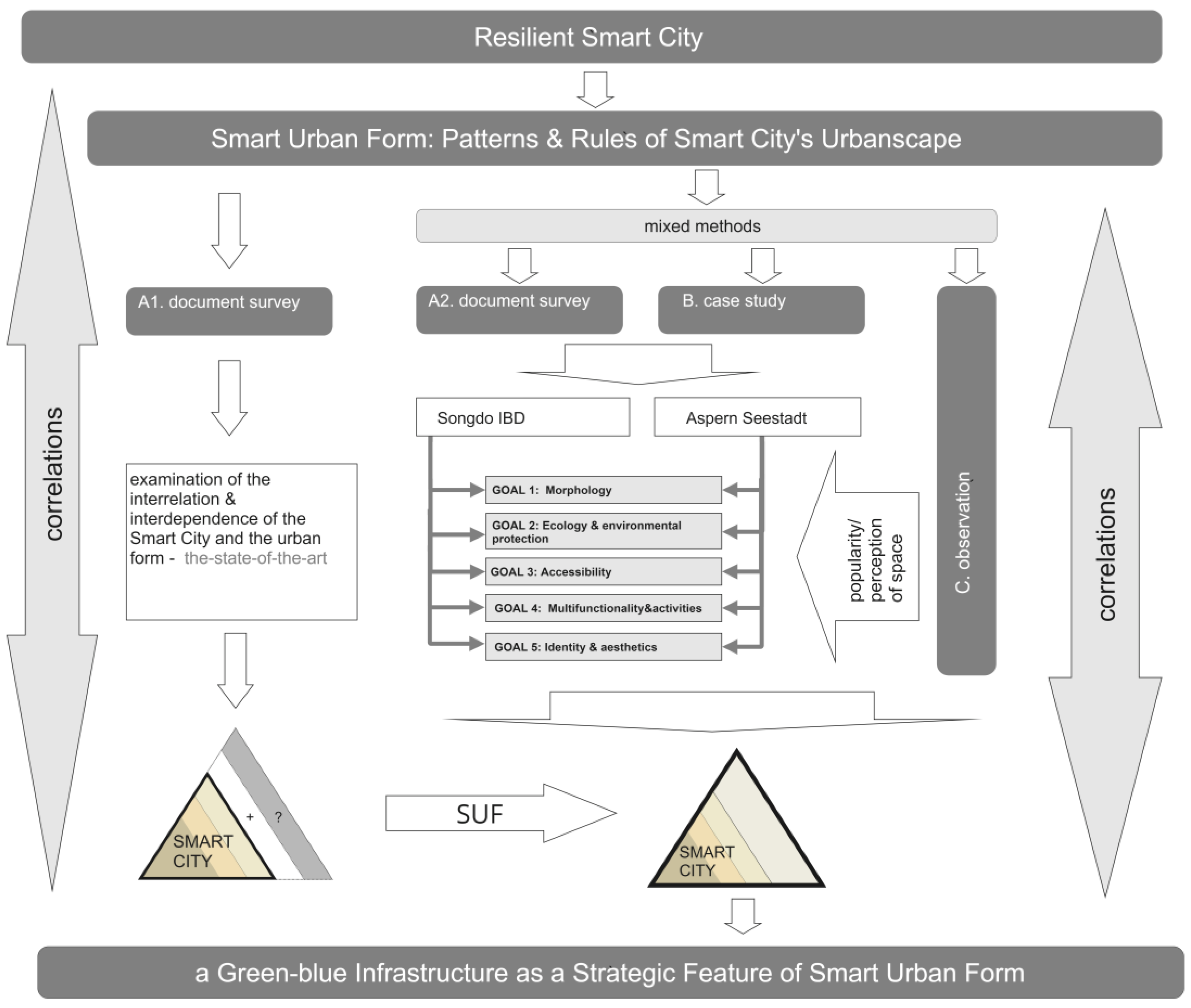
2.1. Methodology
The research methodology is presented in
Figure 1.
The research methods, tools, and the purposes behind their use are listed in
Table 1. The methodology is divided into two major steps.
Step 1 is based on tool A1 and consists of an analysis of the literature, which is to give a critical overview of current research and an indication of a correlation between urban form with an SC as a concept. This step is intended to find gaps in insight into an SC as an idea and its correlation with urban form.
Step 2 consists of assessing SC cases, the Songdo IBD and Aspern Seestadt, with a particular focus on their blue–green infrastructure. This step is based on mixed (qualitative and quantitative) methods and includes the following: an analysis of the literature (a case-study-oriented critical review and analysis of municipal reports, policies, and planning documents, including archival sources), observation methods, and a multiple-case study. The specific purpose of the use of the mixed method presented is explained in
Table 1.
In order to obtain objective, universal, and measurable results in Step 2, a unified measurement tool was used to evaluate the spatio-functional conditions of the selected SC’s blue–green infrastructure. Due to the lack of existing tools, the author created a new original measurement tool in the form of a checklist with the emphasis on five specific goals (detailed information is presented in
Section 2.2). Both of the cases studied, the Songdo IBD and Aspern Seestadt, were examined using the tool.
The combined outcomes of Step 1 and Step 2 can provide insight into an SC as a concept and its equal interrelation with the urban form. This can also, as a result, strengthen the resilience of the SC concept.
2.2. The Five SUF Goals Checklist—A Tool for Measuring the Spatio-Functional Potential of a Smart City’s Blue–Green Infrastructure and Recreational Areas
The research objective of methods A2, B, and C was to qualitatively and quantitatively assess the urban form and spatial factors with a particular focus on the blue–green infrastructure of selected case SCs: Songdo IBD and Aspern Seestadt. To achieve this goal, a multiple-case study was conducted using a specifically designed original tool.
Based on the references of research tools listed in
Table 2, the following five goals and their subcategories were defined as follows:
GOAL 1: Morphology—The goal consists of the assessment of several factors: 1.1. compact urban structure (size), 1.2. an urban structure that is easily understandable for users—e.g., basic urban grid (configuration), 1.3. the human scale of the urban structure (density), 1.4. the presence of green and blue infrastructure, public spaces, open space (land use), and 1.5. master plan as a basis of project implementation
GOAL 2: Ecology and environmental protection—2.1. the presence of green and blue infrastructure/high percentage of the space with vegetative cover, 2.2. biophilia, 2.3. well-being-oriented design thanks to big-scale green areas, 2.4. biodiversity, and 2.5. renewable energy for zero CO2 emissions solutions, etc.
GOAL 3: Accessibility—The goal consists of the assessment of several factors: 3.1. the proximity of green and blue infrastructure and recreational spaces (400 m distance), 3.2. traffic priority (pedestrian traffic preferred), 3.3. the existence of an extensive public transport infrastructure, 3.4. the existence of an extensive bike lane infrastructure, and 3.5. diversified parking lot structure.
GOAL 4: Multifunctionality and activities—4.1. multifunctional character of green and blue infrastructure and recreational spaces, 4.2. sense of welcoming and liveable and vital public spaces for different social and age groups, 4.3. technical, spatial, and time/process inclusiveness of spaces, 4.4. active ground floors of surrounding development (retail, public functions, etc.), and 4.5. an easy identification and variety of green and recreational spaces in order to counteract spatial monotony
GOAL 5: Identity and aesthetics—The goal is to assess the following: 5.1. the continuity of local identity/preservation of historical and cultural heritage, 5.2. the creation of new areas of high identity value/new landmarks/new architecture icons, 5.3. the human scale preservation and enhancement of the sense of safety, 5.4. the emphasis on individualized design rather than typified solutions and good orientation in space, and 5.5. the originality and high quality of aesthetic and material solutions for development, public spaces, and street furniture.
As a result of this research stage, a new measurement tool of the spatio-functional potential of smart cities’ blue–green infrastructure and recreational areas was created. The form of the tool is a checklist with the highlight on the five goals. These five goals may be considered as the smart urban form (SUF) goals in the perspective of the blue–green infrastructure. (For further information of the SUF see
Section 3.1)
The indication of fulfillment of the SUF goals according to the measurement tool is thought to be an assessment and evaluation of each goal and its subcategories. A single point is given if the requirements of a goal are fulfilled, half a point is given if they are partially fulfilled, and no points are given when there is no fulfillment observed. The total amount of points for each goal category is compared to a maximum fulfillment level.
‘
The five-SUF-goals-checklist—a measurement tool for measuring the spatio-functional potential of a smart city’s blue–green infrastructure and recreational areas’ is attached as a
Table S1 in Supplementary Material.
2.3. Case Presentation
At this stage, the research objective was to evaluate two existing flagship SCs. It was intended to examine two different types of SCs: a greenfield type (the Songdo IBD) and a brownfield type (Aspern Seestadt) to obtain the most objective outcomes. A master plan as a basis for spatial development of the areas was required. Both the geographical location, cultural background, and SC typology of the cities were intentionally diverse. This can allow for defining a guideline in terms of smart urban form and assessing the role of blue–green and recreational infrastructure as its strategic component.
2.3.1. The Songdo IBD
Songdo can be considered the world’s most well-known SC and one of a few, if not the only, fully well-functioning greenfield SC in the world [
32,
33]. The Songdo project was an attempt to create a model of the development for future cities. The vision of Songdo as an SC consists of a combination of highly advanced information and ICTs present in almost every tangible and intangible aspect of the city (features of a smart city and ‘Ubiquitous city’ or ‘U-city’) with some sustainable development goals (mainly the features of the ‘Green city’ or ‘Eco-city’). The ‘Eco-City’ for Songdo means a relatively high number of green and recreational areas (compared to other Korean cities) [
34] as well as a high number of LEED-certified buildings [
35]. Because of this, Shwayri coined the term ‘Ubiquitous-Eco-City’ [
36] to describe Songdo.
Songdo is located in the Incheon Free Economic Zone (IFEZ). It is one of the three key cities of this zone, along with Yeongjong and Cheongna. The IFEZ was established in 2003 as a strategic development area designated by the Korean government to create the economic center of north-east Asia. The area of the zone covers over 130 km
2 around these three international cities and the Incheon airport and seaport [
37].
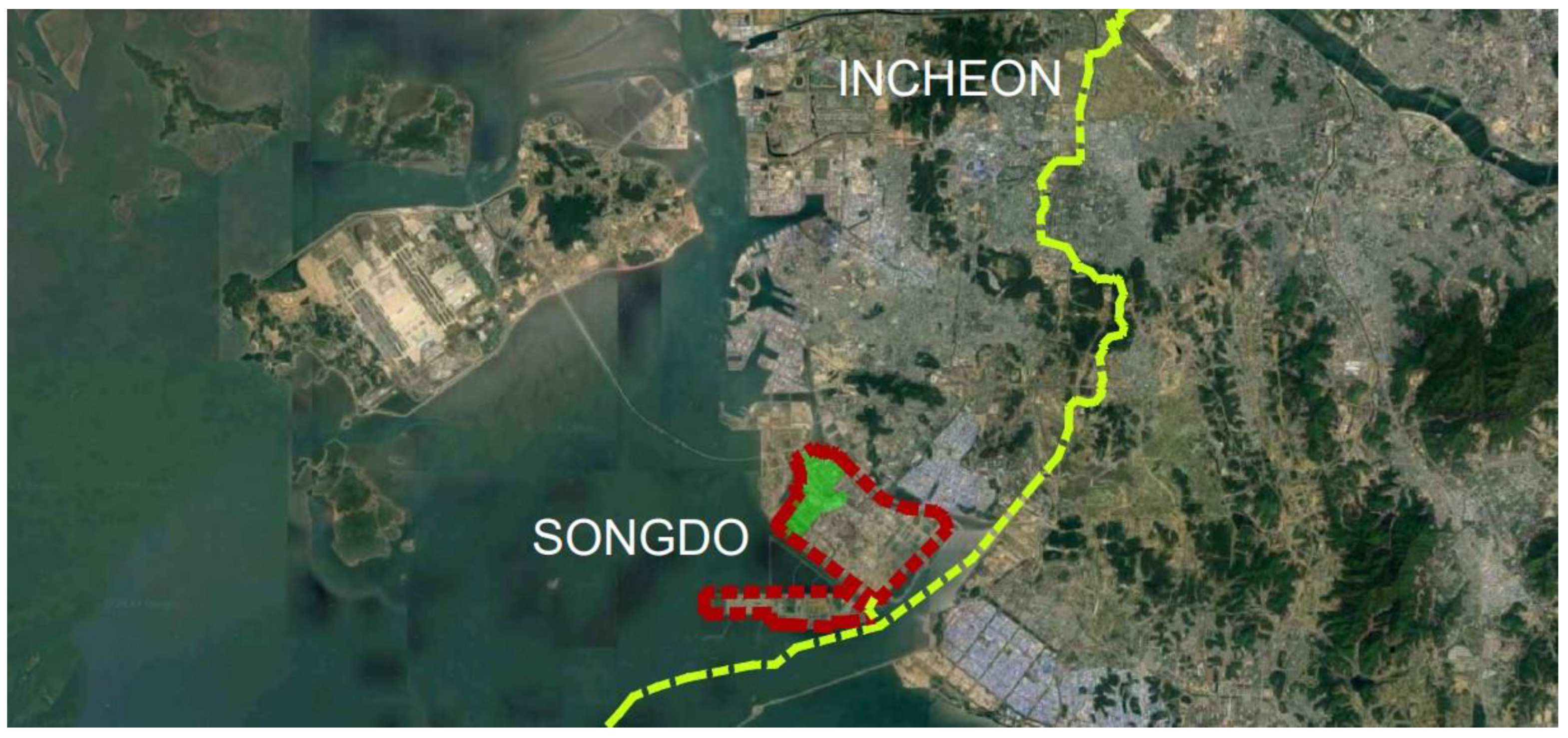
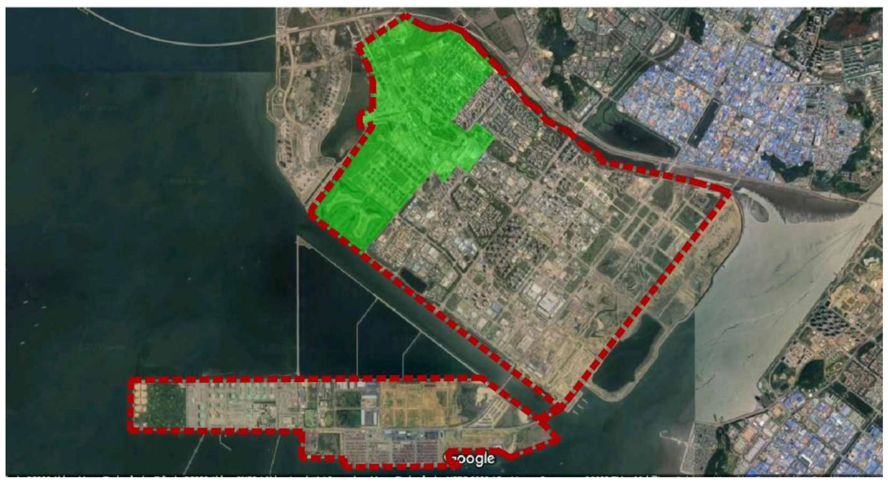
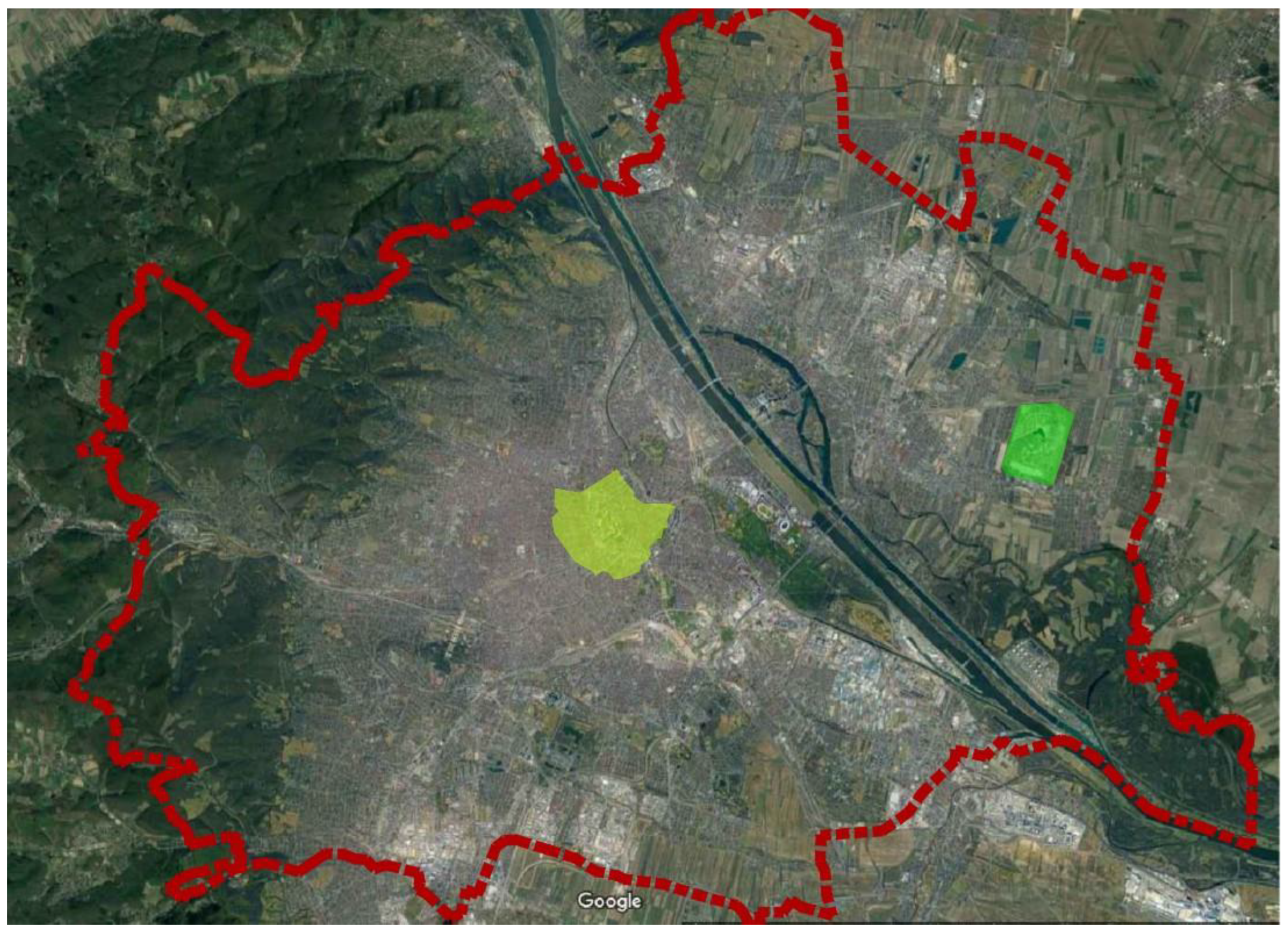
According to the project’s creators, Songdo is a tabula rasa city, a rare example of creating a new city from scratch, of total external and territorial expansion of the city. Songdo is also recognized as such in popular opinion. However, considering the location conditions (both the proximity to the city of Incheon and the location within Incheon’s borders), Songdo should de facto be classified as an independent area within a larger agglomeration and the Songdo IBD (the Songdo International Business District) should be classified as a district (part) of this area, as shown in
Figure 2.
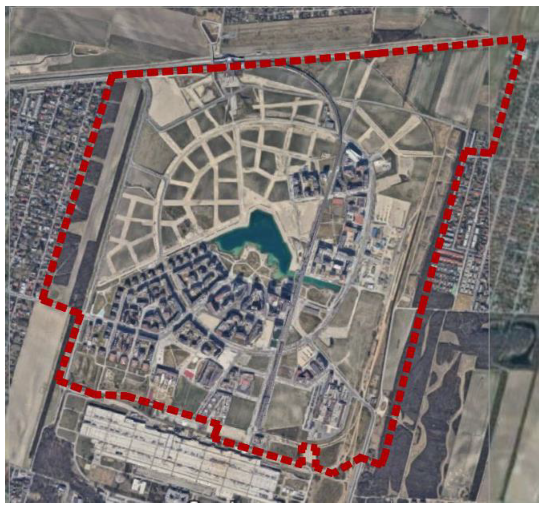
The Songdo IBD is located in the northern part of the city, as shown in
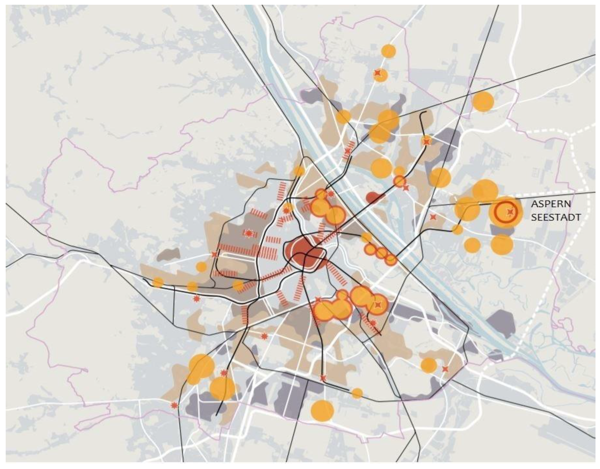
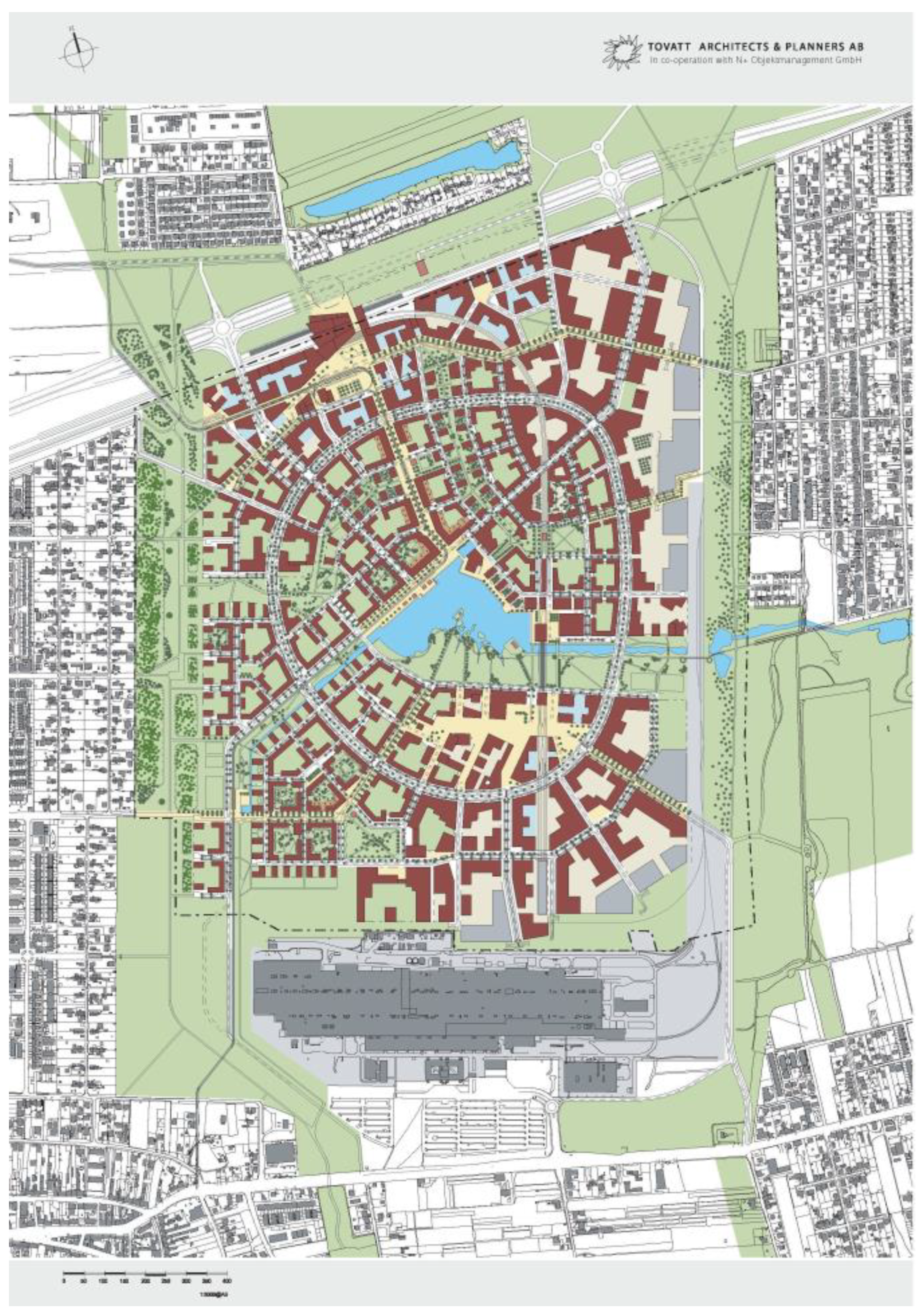
Figure 3, and is considered its hallmark.
2.3.2. Aspern Seestadt, Vienna
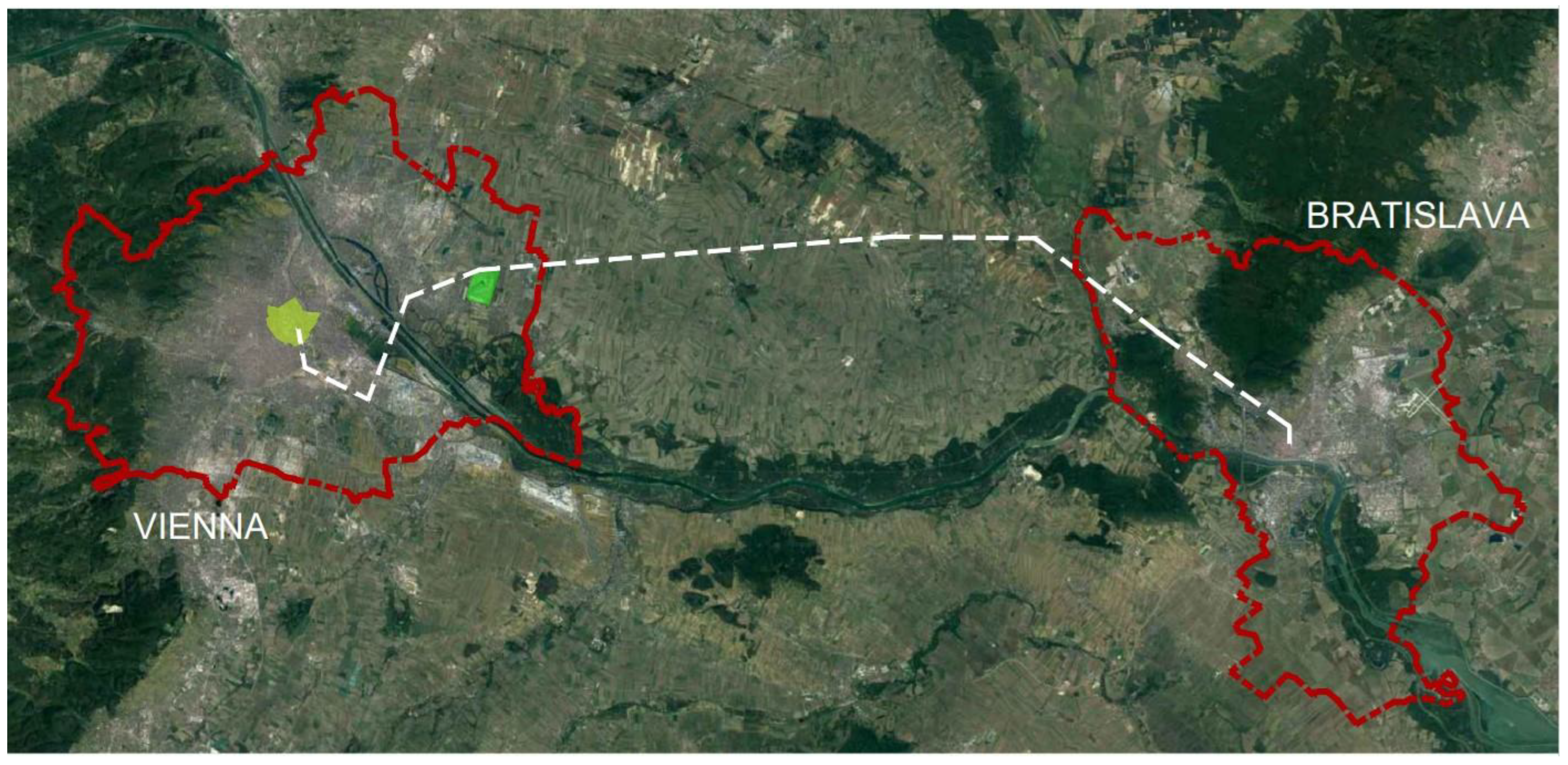
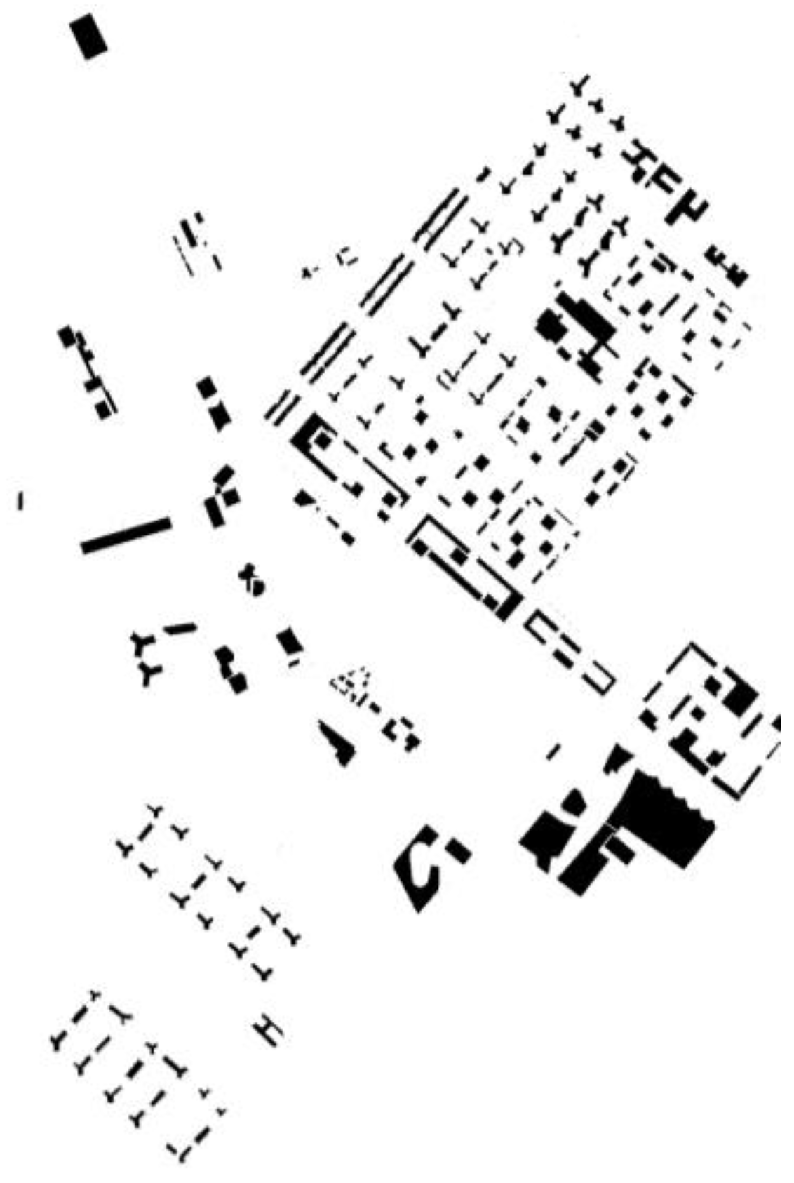
The Aspern Seestadt district is a flagship SC project in Europe. It is located in the eastern part of Vienna. At first glance, the location can be described as peripheral, as shown in
Figure 4. However, it is not accidental as the district is placed on the strategic axis between Vienna (Austria) and Bratislava (Slovakia), almost in the central part of the CENTROPE multi-level international cooperation region which consists of four countries: Slovakia, Austria, the Czech Republic, and Hungary) [
38] (See
Figure 5).
Aspern Seestadt is an example of controlled external and territorial expansion of the city as a fulfillment of the existing urban structure. The district can be characterized as a city within a city. Therefore, it may be defined as both a brownfield SC (in the context of the entire city) or a greenfield SC (on a micro scale understood as a new district).
The plan for the spatial development of Vienna included in the STEP 2025 document [
39] shows that the Aspern Seestadt district plays a significant role in the development of the city, as shown in
Figure 6. The importance of the new district can be noted on three levels:
- 1.
Sustainable (controlled and well-planned) territorial expansion of the city. Aspern Seestadt is planned as a new area of the city’s development;
- 2.
Embracing the multifunctionality of Vienna (the goal is to create a multifunctional urban subcenter in the district);
- 3.
Adapting the city to the growing population without compromising the quality of life of its inhabitants. The specific objectives of the Aspern Seestadt project, among others, are [
40] the promotion of and research on the SC idea as well as ensuring high quality of life for Vienna’s residents thanks to the following:
- –
A high share of publicly accessible spaces (almost half of the district’s area is to be parks, squares, and streets) with an emphasis on ensuring a diverse array of public spaces;
- –
A diversified functional structure of development (the aim is to achieve a balance between the share of residential development and the number of jobs provided by services, educational functions, etc.);
- –
Creation of attractive public green recreational areas.
Figure 6.
Vienna’s spatial development plan. Source: STEP 2025, Stadtentwicklungsplan, Magistrat vom Wiener Gemeinderat, Stadt Wien, 2014, p. 69 [
39] (public domain). Strategic development parts of Vienna are marked with orange dots with red borders. Aspern Seestadt is one among them, and has one of the highest priority rate. (Author’s modification in the description of the location of the Aspern Seestadt district).
3. The Correlation between the Smart City Concept and Its Urban Form—A Literature Review (Results Step 1. Method A1)
The goal of this section is to provide a critical overview of the recent state-of-the-art advances and an indication of a correlation between urban form and an SC as a concept.
The literature review showed that, in general, there are some observable correlations between an SC as an idea and an SC’s urban form. For instance, the Crystal in London, a Siemens exhibition pavilion, opened in 2013 [
41] and is one of the most interesting examples of the connections between urban form and the SC concept. The Crystal presents an SC concept on two levels: literally (as a smart building) and content-wise (in terms of the topics of exhibitions housed inside). The Crystal tackles the SC phenomenon in a comprehensive approach. According to the exhibition there are the three main foundations of a sustainable SC: quality of life, economy, and the environment, which remain balanced through proper management. The exhibition addresses the city as an entity based on a general-to-specific pattern. The main theme of the exhibition are three interacting scales: mega, macro, and micro. The mega scale presents the global conditions shaping modern cities and seeks answers on how to counteract the challenges of intense urbanization. The macro scale refers to contemporary cities: their urban form and urban planning tools. This scale refers to the question as to how future cities should be designed. The micro scale emphasizes the perspective of city residents and their perception of urban space. It is worth noting that the exhibition in the Crystal was one of the first to highlight the need to incorporate urban planning, urban planners, and urban tools in the SC concept. Cohen [
42] also listed green urban planning as a strategic feature of the SC concept. Yet, in both cases, little detailed information on how to produce a sustainable SC is presented. Numerous questions, such as: ‘How should the SC planning system look like?’, ‘What are the necessary urban form components and planning tools to incorporate while creating an SC?’, and ‘How should the implementation pattern of the SC concept at: planning, implementation, execution and operating stage specifically look like?’ remain unanswered. In fact, the Crystal may be perceived more as an attempt to draw attention to the SC idea instead of a guideline on how to implement it.
In a more general scope of view, in 2016, there was a breakthrough moment for the importance of spatial and urban planning in terms of an SC. The reason for this sudden popularity was ‘The new Sustainable Development Goals’ report published by the UN in 2015 [
43]. The report’s Goal 11 referred to inclusiveness, security, sustainable development, and the sustainability of cities and human settlements. This was followed by the UN conference Habitat III in Quito, Ecuador, in October 2016. The conference opened a new chapter in the history of urban development, placing cities, urbanization, and urban planning at the center of the New Urban Agenda as a new UN Declaration on sustainable cities and human settlements for all [
44]. These events resulted in an exponential increase in publications on the SC concept. However, according to the findings of Min et al. [
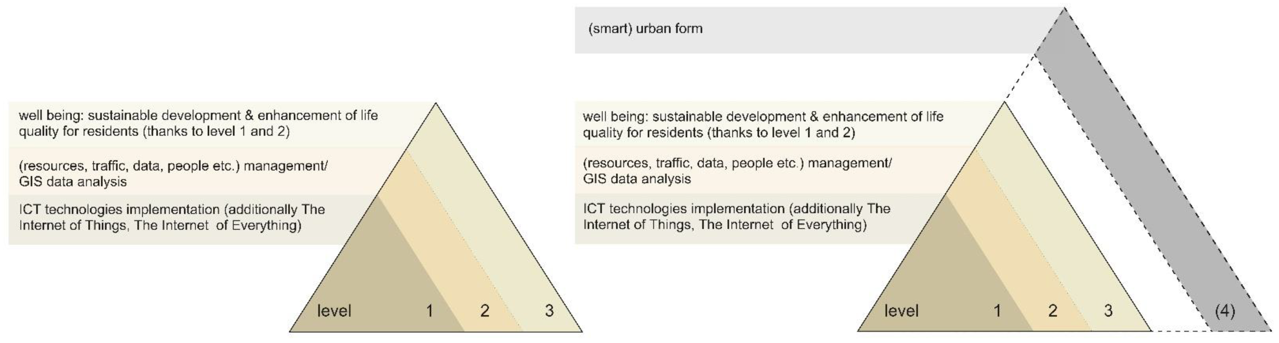
15], the relationship between spatial planning and urban planning and the SC concept in publications released from 2016 to 2019 came down mainly to the use of existing data analysis and GIS data. It can therefore be assumed that the technological aspects of SCs were particularly emphasized, based on the improvement in methods and processes of collecting and processing data as well as ways of visualizing them. Simultaneously, the urban form of an SC was marginalized. This comes as a surprise since any city, even an SC, cannot function without its physical structure. Should the SC idea, in conclusion, be treated as an amorphous phenomenon? Or does its urban form need further extensive investigation? The second conclusion appears to be more rational from the perspective of producing a resilient SC.
The most recent state-of-the-art according to a study of the definitions of the smart city conducted by Gracias et al. in 2023 [
45] shows three main levels of understanding an SC as a concept. These are the following:
- 1.
ICT implementation (additionally, The Internet of Things and The Internet of Everything can be added);
- 2.
Management (resources, traffic, data, people, etc.)/GIS data analysis;
- 3.
Well-being understood as the sustainable development and enhancement of the quality of life for residents due to the implementation of the elements mentioned above [
46].
As presented, four years after the publication of the paper by Min et al. [
15], the urban form of an SC still remains a marginalized issue. Is it enough to provide these three levels to achieve a well-functioning SC? Even the authors themselves emphasize that ‘the technology is not a silver bullet’ [
45] that is able to solve all pressing urban problems. So, how can we contract the urban challenges in an SC?
Sustainability may be an answer to this question. The connection between the SC concept and sustainability is often addressed in the literature [
14,
47,
48,
49]. José and Rodrigues [
49] identify ‘Ecosystem Development’ as one of five key SC challenges. In detail, however, the term refers to ‘collaborative innovation, governance models, business models, and citizen engagement’. The focus is placed on governance methods and the urban form seems to be left out of the scope of the study. Kolokotsa et al. [
50], in their research on the intersection of greenery and an SC, which may indicate the connection to sustainability, highlight the need to incorporate nature-based solutions as a method to increase the resilience of SCs. Green infrastructure is a key element of the urban form of a city, yet Kolokotsa et al. narrow this intersection to a web-based data platform that either integrates several sensors connected to nature-based solutions for covering performance indicators in a city or stores data of different scales on nature-based solution implementations in one place. One may get the impression that the connections between sustainability and an SC refer mostly to the methods of managing natural resources or to collecting and analyzing data. The literature review showed that the physical structure of an SC is not seen as a key element that provides a stable and sustainable living environment. This perspective seems limited in terms of producing a sustainable urban environment and reveals another gap in understanding an SC.
In summary, there are still a small number of studies on the urban form of SCs. Nevertheless, the need to take into account urban planning in the concept of a smart city is increasingly emphasized [
17,
18,
19,
20]. In this context, there are references to smart urbanism (SU). SU regards three aspects: physical urban structure, ICTs, and their mutual influence [
16,
51]. In practice, however, many researchers note a significant urbanism and urban planning deficit in SU [
16,
19,
52]. The SU idea is seen to refer rather to self-promotion or increasing the economic competitiveness of a city than to actually improve an urban space and the quality of life of its inhabitants [
19]. The criticism emphasizes the need to take into account the urban context of a given city in which the SC idea is implemented [
19] given the fact that the SC idea is implemented mainly in existing cities (brownfield SCs) is particularly important.
Furthermore, there is research on the relationship between SCs, urban form, and planning. In this context, Anthopoulos and Vakali’s findings are notable. Anthopoulos and Vakali focused on the coexistence of a smart city and an urban form and on the mutual relations between them ‘in the context of mutual support and benefits’ [
53]. Unfortunately, the urban form is not perceived as a component of an SC but as an independent element that should take into account smart solutions in the city. This conclusion seems to be insufficient in terms of shaping an SC’s well-functioning urban form. In fact, an SC and its urban form interact with one another equally and are fully interrelated.
In conclusion, noticeably weak indications of a correlation between urban form and the SC concept were found in the literature review. The biggest gap in understanding an SC seems to be its physical structure. Indeed, it is perceived mostly as an independent and separated element. The role of (smart) urban form in the SC concept according to the state of the art is presented on the right in
Figure 7. This seems to be surprising since any city, including an SC, is built out of two systems, a physical structure and inhabitants [
54], and should be perceived ‘not as artefacts, but as systems built more like organisms than machines’ [
55]. The literature review demonstrated a need to examine the relationship between urban form and the SC idea.
In order to provide answers on how to shape the urban form of an SC, an identification of a smart urban form (SUF) is required. Secondly, a resilient SC should incorporate SUF as a strategic, interdependent, and equal element of the SC concept. But, what does it mean in terms of the blue–green infrastructure of an SC?
3.1. Smart Urban Form (SUF)
While regarding the possible correlation between the SC concept and urban form as a possibility of mutual and equal interaction between them, there is a need to define urban form components that contribute to the smart features of an SC’s urbanscape. These components may be considered smart urban form (SUF). In the author’s previous research [
56], three core elements of SC necessary for shaping an SUF were coined as follows:
- 1.
The idea of a SC should be treated holistically, not only as a process of managing data, the city, residents, and resources using ICTs;
- 2.
The urban form is an integral element of the SC concept;
- 3.
The implementation of the SC idea should be based on an individualized approach towards a city or its fragments.
The holistic approach to the SC concept should take into account several key aspects: 1. the implementation of the principles of sustainable development (spatial, communication, economic, and environmental), which focuses mainly on four smart values defined by Giffinger [
8]—smart mobility, smart environment, smart living, and smart management; 2. priority of residents’ needs in the process of creating a brownfield or greenfield SC; 3. striving to improve the quality of life of residents in three dimensions: physical (through the methods and quality of building the urban form), social (through focusing on cohesion, integration, and social inclusion) and network (providing access to data, systems and the possibility of exchanging data based on modern technologies); 4. using a management model based on multisectoral participation with a particular emphasis on the bottom-up approach; and 5. supporting advanced ICTs in improving the quality of life and urban space. This may be considered the general characteristic of a successfully shaped SUF. Furthermore, more detailed SUF features were defined by Giffinger. As a rule, an SC’s urban form should include the following:
- –
Multifunctional and easily adaptable space;
- –
A wide variety of recreational and activity zones for residents (spatial and functional differentiation);
- –
Green infrastructure and public and recreational spaces as key elements of an urban form;
- –
Emphasis on individualized design rather than typified solutions;
- –
Easy identification and variety of spaces in order to counteract spatial monotony;
- –
Originality and high-quality aesthetic and material solutions of development, public spaces, and street furniture;
- –
Emphasis on continuity of the network of green infrastructure, urban interiors, and public spaces and their synergy (as spatial and symbolic connectivity) as a key element;
- –
Reinterpretation and reassumption of the classical functions, purpose, and meaning of urban form elements (e.g., by giving a new meaning to space);
- –
Ensuring accessibility and communication connections and composition links both locally and globally;
- –
Implementation of ICTs to support the principles of sustainable development, rational management of natural resources, and cities’ management of spaces and inhabitants.
This understanding of SUF provides enhanced insight into the physical structure of an SC.
The aspects mentioned above are the basis for further investigation of the urban form of the Songdo IBD and Aspern Seestadt in the scope of their blue–green infrastructure as a strategic feature of SUF. The SUF requirements were also included in the proposed checklist tool.
4. Results (Step 2. Methods A2, B, and C)
The assessment of the SC districts required a high granularity to ensure that the five SUF goals checklist tool produces objective results. For this reason, the tool was based on mixed methods and an extended database: 1. print and online sources (municipal reports, policies, and planning documents); official websites of SC projects and the local municipal authorities; and archival sources (in Vienna’s case); 2. urban and data analyses (master plan analyses) and authorial urban analyses based on global (e.g., websites) and local databases including statistical data from the databases of the municipal authorities of Songdo and Vienna).
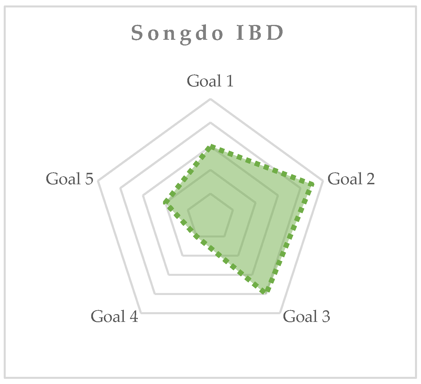
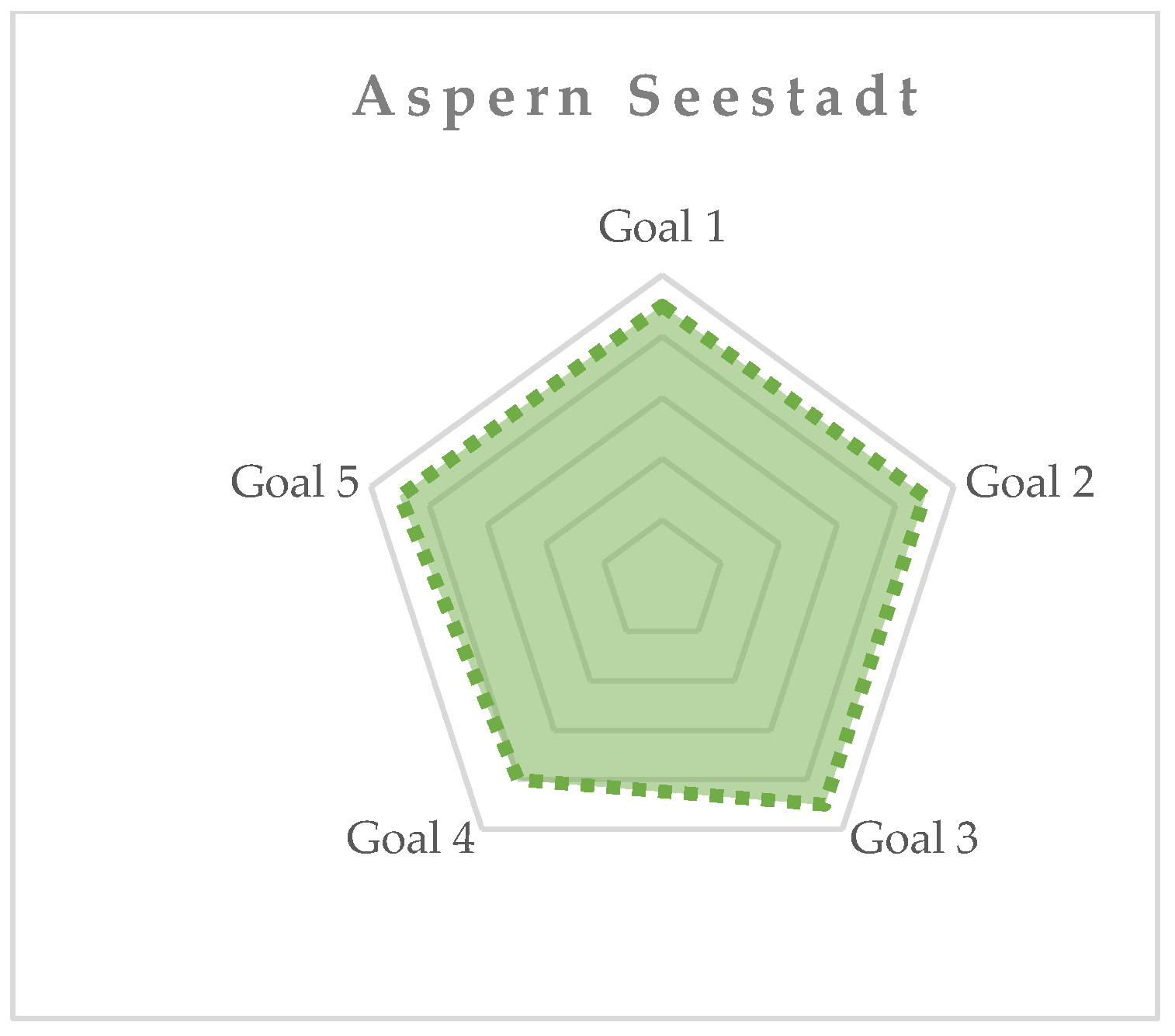
A synthesis of the research results is presented in
Figure 8 and
Figure 9. The Figures present a comparison of the results of the study spread over different groups of factors (goals 1–5).
A detailed assessment of the correlation of all five SUF goals with the urban form of the Songdo IBD and Aspern Seestadt is presented in
Table 3. The method of the assessment is in accordance with the methodology presented in
Section 2.2. For each positive correlation (+), a point was given and for each half-fulfillment of a goal’s agenda (+/−), half a point was given. No correlation (−) equaled 0 points.
In general, all five goals were present at the core of the implementation ideas of the SC concepts, as mentioned in the case presentation (see
Section 2.3.1 and
Section 2.3.2). The detailed study conducted by the usage of the measurement tool showed higher fulfillment levels of the SUF goals in Aspern Seestadt. As shown in the schemes, the outcomes in this district display a mostly even high-level goal fulfillment. The obtained outcomes were also compared to the district’s realm by the observation methods. In general, the blue–green infrastructure and spatial functioning of the district is considered as rather successful.
Whereas, the Songdo IBD district is oriented heavily towards goals 2 and 3. The weakest link of the goals’ fulfillment is visible for the goal 4, which displays itself in the popularity and the perception of the space. (For more details see
Section 4.4.)
While comparing both districts, the most distinctive differences in the goals’ fulfillment between both SCs are visible for goals 4 and 5. The lowest correlation factor for both SC districts was found in the fulfillment of goal 4 factors. This is unexpected due the agenda of both SC districts, which originally claimed to be citizen-friendly spaces. The multifunctionality and inclusiveness of the space appears to be as hard to achieve as it is vital for the SUF. The study showed a weak correlation level of goal 5 in Songdo IBD. This may be connected both with the strategy implemented in the district as well as with creating a large-scale urban structure from scratch.
The observation methods proved as well that the high fulfillment level of a specific goal factor equaled better social and spatial functioning of the urban structure of the studied cases in a given aspect. Looking at the synthesis of the research outcomes, Aspern Seestadt seems, firstly, to be more successful and, secondly, for this reason, also more resilient as an SC than the Songdo IBD. This is due to even levels in the fulfillment of specific goals.
As the case study demonstrated, the even level of SUF goals is desirable for an SC as it assures the harmonious functioning of a space and assures high value for its users. The orientation toward a specific SUF goal without taking into consideration the other ones, as it happened in Songdo IBD, may result in the worse spatio-functional potential of a green-blue infrastructure of an SC. This observation proves the value of ‘The five-SUF-goals-checklist—a measurement tool of the spatio-functional potential of smart city blue–green infrastructure and recreational areas’. However, it is recommended to test the tool on a different pool of SCs to demonstrate its universality.
4.1. Goal 1—Morphology
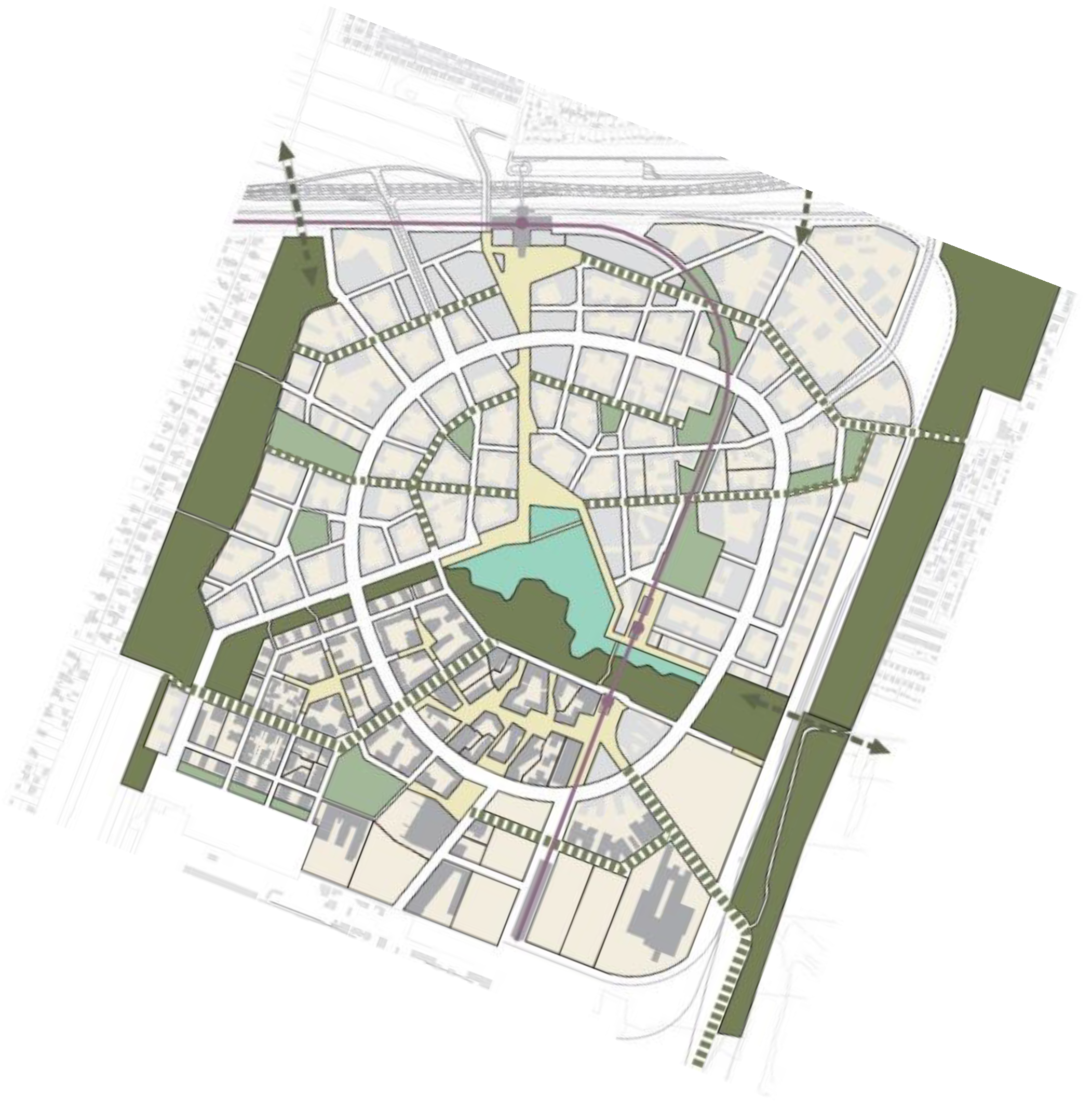
Aspern Seestadt displayed a higher fulfillment of goal 1. However, both SCs consist of compact and easily understandable, yet diverse, urban structures thanks to the master plans, which were the basis for the implementation of the SC idea in both districts as shown in
Figure 10 and
Figure 11.
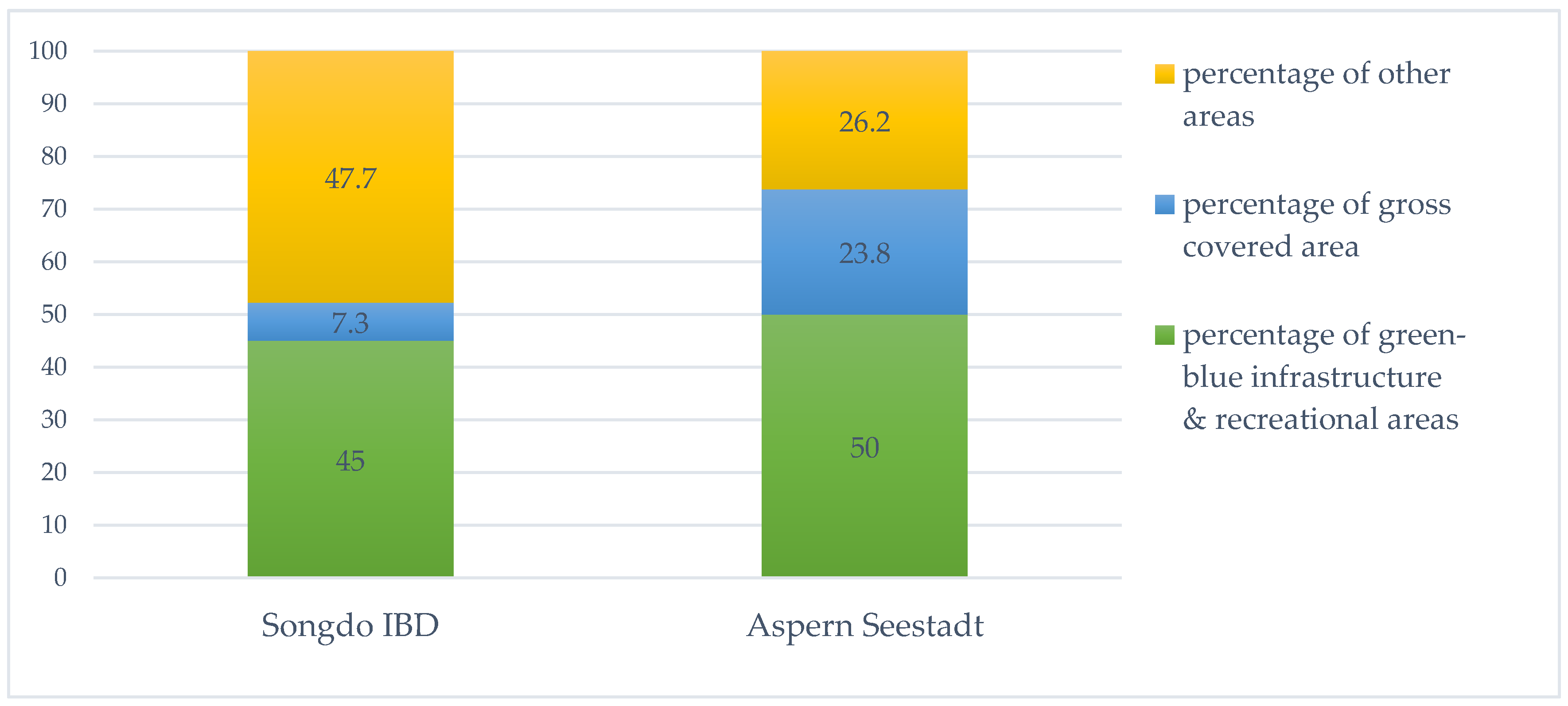
The presence of blue–green infrastructure in the Songdo IBD and Aspern Seestadt is easily noticeable. In both SCs, green and recreational areas form around 50% of the entire area of the districts, which indicates the significance of blue–green infrastructure as a feature of these districts’ urban forms (See
Figure 12).
Figure 12 also shows that the human scale criterion was not the goal for the urban structure of the Songdo IBD, which is manifested by a percentage of gross covered area and, additionally, by the height of the development. In the Songdo IBD, the weighted average height of the buildings was 14 storeys [
57] whereas in Aspern Seestadt, the height of the development varied from 1 to 12 storeys [
58].
While the master plan of Aspern Seestadt was respected throughout all implementation stages of the SC concept, distinctive modifications were made in Songdo. The differences may be noticed, among others, in the spatial layout of the development. In the master plan, there had been a high share of block-type development, while the development as-built was based on tower block typology. This alternation may have had an influence on spatio-functional factors of this SC district. (See
Figure 13)
4.2. Goal 2—Ecology and Environmental Protection
In general, in both districts, goal 2 was noticeable and reached one of the highest correlation rates of all the goals. This was expected since technology and environmental protection was the foundation of the SC vision for both districts. The lowest indication of the goal was discovered with regards to the biophilia criteria. Despite the objectively high number of green infrastructure in general, the observation methods showed that except from the main green areas, such as parks, etc., the biophilia factor was marginalized (e.g., on the streets, walk-lanes, etc.)
4.3. Goal 3—Accessibility
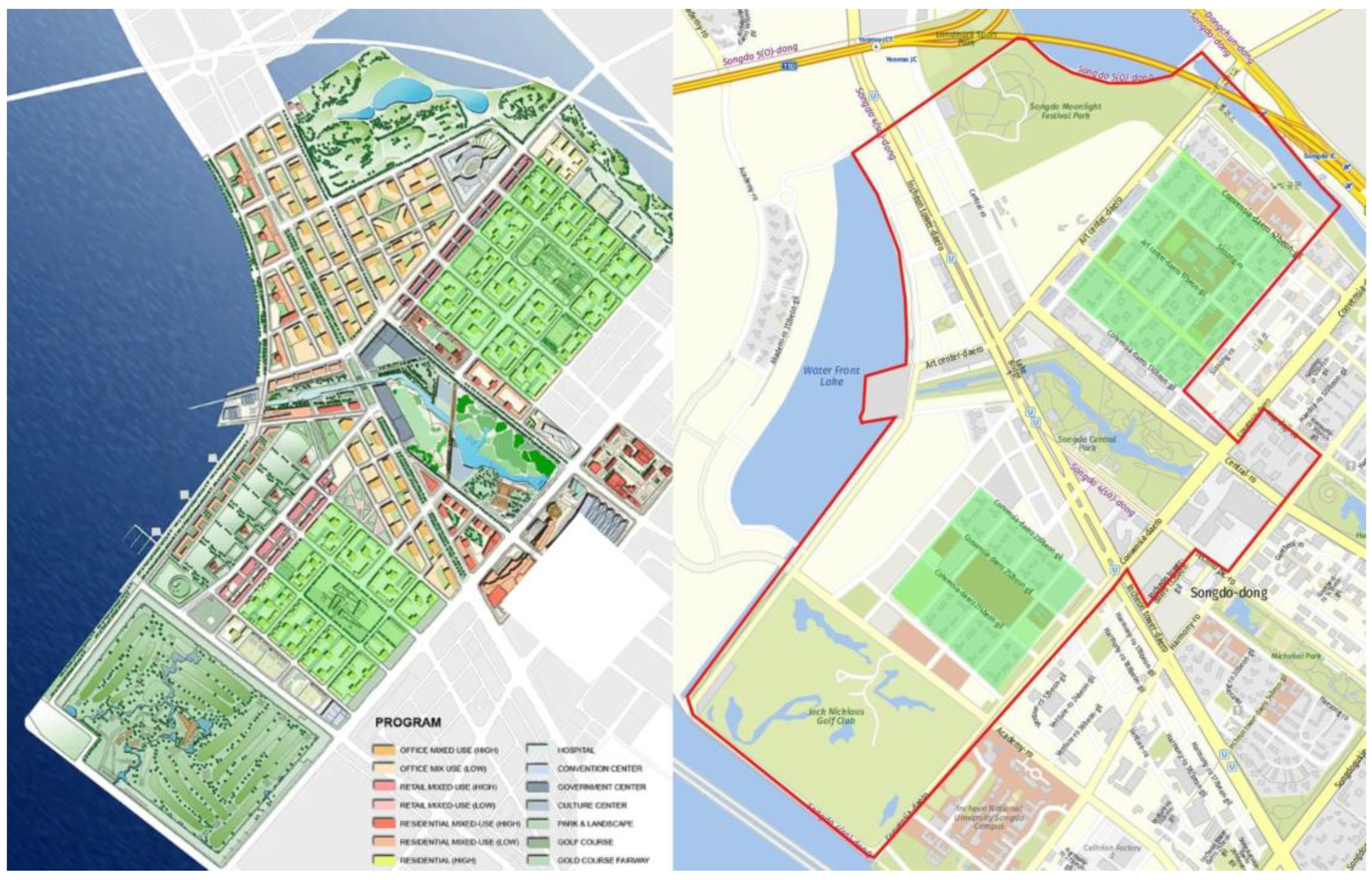
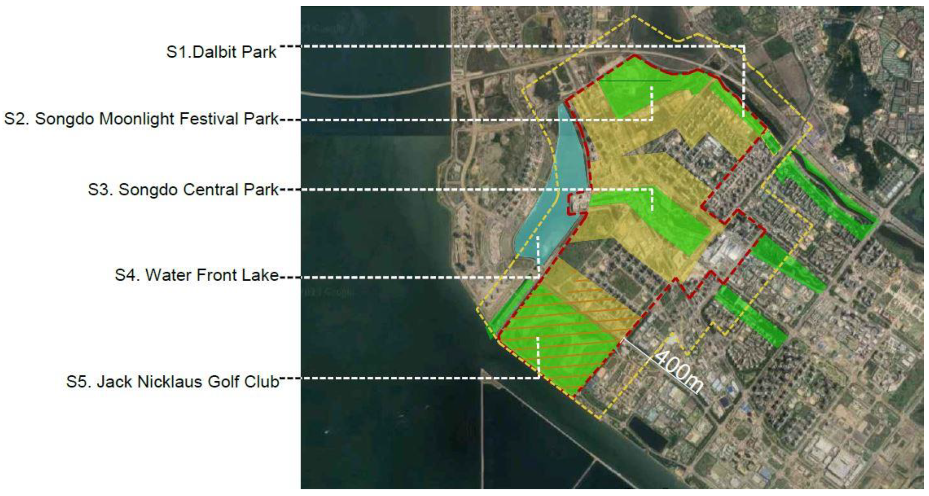
Although the blue–green infrastructure percentage in both SC districts is comparable, its accessibility in Aspern Seestadt is more comprehensive. This is due to the high number of smaller recreational areas such as parks, gardens, linear greenery along streets, etc., as well as the areas’ location. Thanks to this, the entire district has access to green or blue infrastructure within a walking distance of 400 m. The diversity in green and blue infrastructure is shown in
Figure 14 and
Figure 15. On the other hand, the large-scale green and blue areas in Songdo were not within a walkable range of 400 m, as shown in
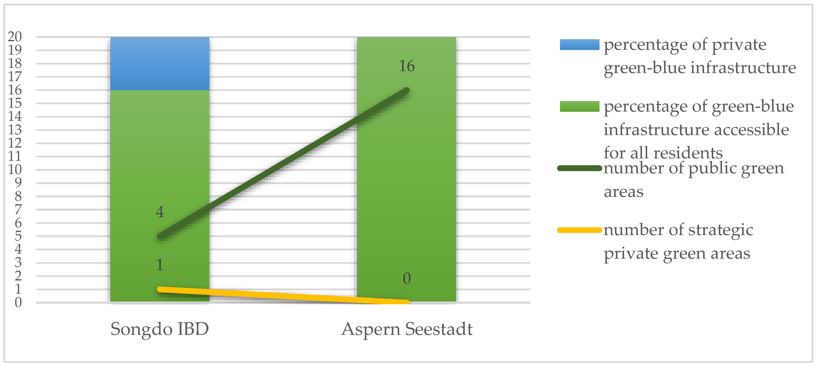
Figure 16.
Figure 17 presents the structure of publicly-accessible blue–green infrastructure in both SC districts. The presence and location of the infrastructure are not the sole factor that refers to a well-functioning blue–green infrastructure of an SC. The ownership structure plays a significant role as well. While in Aspern Seestadt the entire crucial blue–green infrastructure was publicly accessible, in the Songdo IBD, the biggest green area, Jack Nickalus Golf Club, is a private property with restricted access.
In terms of the priority of movement, both urban analyses and observation methods showed two contradictory approaches in the SC districts. The urban form and spatial solutions in Aspern Seestadt were pedestrian-oriented, while in the Songdo IBD, the priority was given to vehicular transportation. Non-pedestrian movement priority evidently limits the accessibility to blue–green infrastructure.
4.4. Goal 4—Multifunctionality and Activities
The fulfillment of goal 4 indicators was the lowest in both districts. In the Songdo IBD, the lack of the majority of specific goals was more pronounced. This was determined using observation methods as well as by the literature review. The reasons for this can be found in the low functional diversity in individual building areas [
24,
61] sterility; elitism of the city and lack of social diversity [
62,
63,
64]; and spatial monotony and lack of individual city identity [
61,
65]. This may be briefly characterized as the absence of features typical for existing cities, which tend to be flexible and dynamically adapt to the changing needs of residents.
In Aspern Seestadt, although the multifunctionalities and activities of public spaces as well as green and blue infrastructure were one of the most crucial goals of the SC project, the observation methods proved very low social activity in all examples of public space. The weakest link in terms of this are the sense of welcoming, liveable and vibrant public spaces for different social and age groups, and active ground floors of the surrounding development (retail, public uses, etc.). This may be due to the fact that the planned final urban structure and green infrastructure had not yet been finished at of the time of observation. Here, it is worth mentioning the Rote Saite area: the area that is designed to be linear space, a quasi-retreat, and between the frontages of buildings with multifunctional urban pockets in the form of squares. The space is thought to be an inclusive generator of a variety of temporary social activities thanks to planned restaurants, cafes, shops, pocket parks, open-air cinema, galleries, and theatre [
66].
4.5. Goal 5—Identity and Aesthetics
The fulfillment of goal 5 is one of the lowest in Songdo IBD and, simultaneously, one of the highest for Aspern Seestadt. This may be due to the core idea of implementing the SC phenomenon in both districts. On one hand, Aspern Seestadt urban form displays references to culture, history, and heritage—the intangible factor of urban form—by strong connections to the historic part of Vienna. On the other hand, the Songdo IBD was designed from scratch, as a ‘City in a box’ [
24]: a city that can be shortly replicated in any location. As observation methods showed in detail, the scope of view in the scale of urban furniture design in the representative green and recreational infrastructure in both districts, there are successful green and recreational areas of high identity value. There is strong emphasis on the individualized, high-quality, and aesthetically pleasing design and materials. However, in the Songdo IBD, other less significant parts of the district can be characterized as standardized and of a low aesthetic value.
The human scale preservation and the enhancement of the sense of safety seem to play a crucial role for the green and blue infrastructure of the SCs. While European SCs managed to achieve the goal, the Songdo IBD is described as ‘sterile and soulless’ [
65] and a ‘generic, inflexible, elitist, and controlled [urban] environment’ [
24]. Furthermore, an SC is being criticized for being pedestrian hostile. This may be due to a top-down approach at the urban planning stage.
It is worth pointing out the methods of creating the continuity of local identity and preservation of historical and cultural heritage of Vienna in Aspern Seestadt. This continuity is demonstrated in the master plan design of Aspern Seestadt by the references to Vienna’s good historical practices (‘The Ringstrasse’ and the green belt around the city) and reinterpretation of their shapes and functions (See
Figure 18 and
Figure 19).
Figure 18 shows the historical plan of Vienna that features Ringstrasse, built between 1857 and 1890 by decision of Emperor Franz Joseph I [
69] and the green strip surrounding the city. Historical Ringstrasse is a large boulevard in the shape of an irregular polygon that surrounds the historical center of Vienna. It was built in place of the city’s defensive walls, which had been demolished and dictated its shape. Currently, it is the most recognizable urban arterial, with formal and cultural buildings, and serves an inclusive function for residents (and tourists). The newly designed Ringstrasse in Aspern Seestadt presented in
Figure 19 is the main internal transport route in the district and was shaped similarly to the historical street. As Gehl’s team notes in their guidelines for shaping Aspern Seestadt’s public spaces, Ringstrasse is intended as a place of circulation and a connector, not a barrier [
66]. The similarities are easily noticeable, not only by the references to the same name.
The green belts of Aspern Seestadt and Vienna are connected on two levels: physical and metaphorical dimensions. On the first level, the use of a ring of greenery around the urban structure enabled the establishment of a closed complete character of the composition of the new district. This formal compositional limit counteracts successfully uncontrolled urban sprawl. In the metaphorical dimension, despite the different shapes, the green belt corresponds to the typical solutions of historical Vienna.
The presented example of the strengthening of the local identity and heritage may serve as an inspiration for further projects.
5. Discussion
One of the important reasons behind this study was to investigate the spatial dimension of SCs, which is strongly connected to the methods of shaping urban form. The main question of the research was if there were any patterns or rules in how an SC’s urbanscape could or should be shaped. The study aimed to provide answers whether and, if so, to what degree blue–green infrastructure strengthens the ‘smartness’ of an SC and, by extension, its resilience. The hypothesis of the study was that an SC smart urban form is a guarantor of its resilience. It was suspected that the creation of an SUF should be goal-oriented to give a space high spatio-functional quality. In order to prove whether the hypothesis is true, the focus of the study was directed towards two equally important research steps: Step 1. a critical literature review and Step 2. an assessment of two SC cases, the Songdo IBD and Aspern Seestadt, with a particular focus on their blue–green infrastructure.
Step 1 highlighted the main gaps in understanding the SC concept, mainly of incorporating the issue of urban form in creating an SC and perceiving SC’s urban form as an element that is an independent and separated element of an SC itself. Furthermore, it proposed the frames of ‘smart urban form’ which may be useful for the creation of future SCs. It was the basis for further research into the correlation of urban form and the SC concept. In Step 2, the blue–green infrastructure was set as a main research issue as it typically supports cities’ sustainability and by that its resilience. The case study evaluation of the spatio-functional potential of blue–green infrastructure based on Songdo IBD and Aspern Seestadt demonstrated a relationship between the urban form of the districts and the resilience and ‘smartness‘ of these SCs. This was possible thanks to thorough analysis of districts’ urban forms. The study presented certain urban patterns and rules how an SC’s urbanscape may be shaped along with the evaluation of its the spatio-functional outcomes. As explained in
Section 4, Aspern Seestadt reached a higher level and more even general scores of the correlation of its smartness and urban form. In fact, while the ITCs implemented in an SC may quickly become obsolete due to technical progress, the urban form of an SC, in particular one that displays SUF characteristics, is a guarantor of an SC’s long-term resilience. In this light, Aspern Seestadt may be considered more resilient than the Songdo IBD. Furthermore, good practices presented in the case study may serve as a good example of implementing SC values in new urban projects. The results presented indicate that this study’s hypothesis is true.
One must take into account the limitations of the research when analyzing its results. The main limitation of this study is that it was based on a sample of two existing SC districts. However, from a qualitative standpoint, the cases represent different approaches to the implementation of the SC idea. The results of the study may also be discussed in terms of the unfinished urban structure of Aspern Seestadt. However, its completed section already appears to display characteristic features of the entire SC’s project agenda.
As the paper tackles the issue of the physical structure of an SC and the correlation of urban form and the SC concept, streets, basic transport grids, and means of individual and public transportation may also be considered as the study’s focus points. Yet, in order to keep the paper short and to preserve the study’s clarity, means of transportation, such as autonomous vehicles, are excluded from the research objectives. This may also be seen as a weakness of the study.
From the standpoint of previous studies, thanks to the combined steps 1 and 2, this research found interrelations between the character of an SC and its urban form and puts the urban form of an SC at its center. Thus, it bridges a research gap in previous research on the physical structure of an SC. The study also crystalizes the core demand of an SC as defined by Cohen [
42] as ‘green urban planning’, and a perspective presented in the Crystal Pavilion in London [
41] by coining the term ‘smart urban form’ and by presenting the implementation patterns with their evaluation based on the case study of the Songdo IBD and Aspern Seestadt. As a result of the assessment of spatio-functional indicators of the districts, it was possible to formulate strategic identity factors for a resilient SC, such as the scale of the SC project (recommended actions on the scale of a part of a larger entity over tabula rasa scale), the SC type classification (brownfield type recommended over greenfield type), the space classification (recommended internal expansion or controlled outer expansion over total external expansion of a city), and type of implementation process (evolution recommended over revolution). This finding may be of applicative relevance for urban planners, urban policymakers, and project sponsors in their efforts to create new sustainability-focused SCs.
Another challenge of the research was how to measure the smartness of an SC’s urban form. In order to achieve this goal, the five-SUF-goals-checklist—a measurement tool for measuring the spatio-functional potential of a smart city’s blue–green infrastructure and recreational areas was created. In general, the empirical study found that in both SCs, the five SUF goals were observably present. In detail, although both SC districts had sustainability and blue–green infrastructure as key factors in their respective agendas, the research showed that the presence of the blue–green infrastructure was not sufficient to create an SUF and thus a resilient SC. The even levels of the fulfillment of specific goals’ agendas are desirable in order to provide the synergy of the goals, which positively affects the harmonious spatio-functional potential of an SC. It is not recommended to create an SC which is single-goal-oriented as it may result in a worse spatio-functional potential for blue–green infrastructure. Furthermore, it was found that the presence of areas reserved for blue–green infrastructure was not the only significant factor. Their location, ownership structure, and mutual linkages or synergy of recreational areas should also be provided. In these terms, the strategy based on a higher number of smaller functionally diversified areas with thoughtfully selected locations is recommended. This approach ensures the connectivity of green and recreational areas, which seems to be crucial for the fulfillment of goals 1–4 of the five-goal checklist. The lowest correlation factor for both SC districts was found, unexpectedly, in the fulfillment of goal 4. As it appears, the inclusiveness of the space appears to be as hard to achieve as it is vital for the SUF. It was found that goal 5 plays a vital role in the space’s perception and popularity. The attempts to create a local identity for the SUF refer mostly to brownfield SCs, as it is easier to base on a historical and cultural background. Possible methods of creating new identities in greenfield SCs should be further investigated.
The author is aware of the possibly arbitrary subjective character of awarding points in the evaluation while using the measurement tool. This subjectivity may result not only from the season of the year and the time of day of the observation but also from the cultural background of the researcher. In order to provide the most objective research outcomes, the conclusions were formulated based on a mixture of methods. All the methods, A, B, and C, had their limitations. Methods A and B allowed the collection of data for quantitative and qualitative assessment of the urban form of the cases. However, these data were insufficient to evaluate the popularity and perception of the cases’ urbanscape. Method C can be seen as subjective. This is why the partial personal observations were supplemented with a literature review concerning the spatio-functional dimensions of both districts. The combined methods ensured the objectivity of the research outcomes, including the assessment of the space users’ perspective. All the methods were used in the measurement tool proposed in this paper. The five SUF goal checklist—a measurement tool of the spatio-functional potential of smart city blue–green infrastructure and recreational areas—enabled the assessment of the level of fulfillment of specific SUF factors. The observation methods proved that the higher the fulfillment of the five-goals-checklist factors, the better social and spatial functioning of the urban structure globally. This indicates the significance of implementing the proposed in the paper five-goals-checklist while creating new SC urban forms.
However, the research had the differences in the method of observation of two case study SCs: site visits in Aspern Seestadt and Google Earth walks in terms of Songdo IBD. This may also be considered as another limitation of the study. In general, personal site visits provide a better possibility to assess the quality of a space and its functioning (popularity and perception of space) as they provide a more comprehensive perspective. However, global databases such as Google Earth also deliver reasonable amount of valuable information of a venue.
‘The five-SUF-goals-checklist—a measurement tool for measuring the spatio-functional potential of a smart city’s blue–green infrastructure and recreational areas’ is a new tool for the evaluation of the blue–green infrastructure of an SC. It may be implemented in both newly created SCs (as a guideline for shaping methods of a blue–green infrastructure of an SC) and also while studying existing ones for research purposes. The measurement tool, however, cannot be seen as definitive. It is supposed to be a guideline on how to erect an SUF, which must be seen as open to additions. It is worth pointing out that, depending on a specific SC project, its type (brownfield/greenfield type), main agenda, site-specific and cultural conditions, and the significance of a particular goal may vary. The usage of mixed research methods, including observation methods, is necessary to evaluate the outcomes of the implementation methods and the exploitation results of a specific SUF. The author believes the tool should be tested on different SC projects to prove its universality.
6. Conclusions
The study aimed to answer the question as to whether there are any patterns or rules as to how an SC’s urbanscape can or should be shaped. As presented in this paper, there are desirable patterns of shaping an SC’s urban form, such as the scale of the SC project (recommended actions on the scale of a part of a larger entity over tabula rasa scale), SC type classification (brownfield type recommended over greenfield type), space classification (recommended internal expansion or controlled outer expansion over total external expansion of a city), and type of implementation process (evolution recommended over revolution). The urbanscape of an SC should be shaped in accordance with SUF characteristics. The second research question was whether blue–green infrastructure and recreational spaces can enhance smartness and, if so, to what degree an SC can be more resilient. The study found that the SUF can be the guarantor of an SC’s smartness and resilience as it provides high spatio-functional quality of a space.
The outcomes of the research show that the blue–green infrastructure is a key element of the SUF of an SC as the findings of the paper indicate an SC may be considered more resilient when it assures the harmonious functioning of a space and high value for its users. This is possible when the blue–green infrastructure of an SC is oriented towards the five SUF goals (1. morphology, 2. ecology and environmental protection, 3. accessibility, 4. multifunctionality and activities, and 5. identity and aesthetics). The more correlation levels of five goals are fulfilled and the more the level of fulfillment of the goals is equal, the more an SC may be considered resilient.
In the paper, the focus was put on an analysis of an urban form of two existing SC districts, the Songdo IBD and Aspern Seestadt. The study demonstrated certain general characteristics of the urbanscape of both districts with a focus on their strengths and weaknesses in terms of the correlation between their urban forms and five SUF goals. The research shows that green and blue infrastructure is a strategic feature of the urban form of Songdo IBD and Aspern Seestadt. It also proved the correlation to SUF goals and thereby to SC’s resilience.
The paper proposes a tool to measure and evaluate the spatio-functional potential of green and recreational areas of SCs based on the five-goal checklist with focal points on the following goals: 1. morphology, 2. ecology and environmental protection, 3. accessibility, 4. multifunctionality and activities, and 5. identity and aesthetics. The findings of the study open the way to further investigation. The research method presented in this paper can be useful while analyzing existing SC urban structures and it may be applied to the future development of both greenfield and brownfield SCs. In these terms, the findings may serve urban planners, urban policymakers, and project sponsors while determining the future SC project goals and spatial policies as well as the researchers while analyzing existing SC urban structures. Furthermore, good practices presented in the paper may be used as an inspiration for further SC projects. Future research into the five-goal checklist should focus on testing the goals with different SC projects to better rate the universality of the factors.
By adopting an urban-form-based perspective, this study fills a gap in the existing research on SCs. The focus of the paper was not to evaluate the existing SCs but to determine a range of general tendencies in shaping an SC’s urban form based on existing cases. The main message of the paper is to indicate the importance of an urban form for the creation of an SC. The resilience and spatio-functioning potential of a specific SC are strongly correlated with its urban form. The need to incorporate the green and blue infrastructure in the process of shaping an SC’s urban form is central to this issue. Furthermore, the paper proposes a framework for a smart urban form (SUF) by presenting its specific characteristics. In order to achieve an SUF, understood as a successfully functioning urban form of an SC, urban planning incorporation is required in all stages: the design stage, the implementation stage, and the operation stage of an SC concept. It should be noted that this strategy should be consistent throughout the entire process.
The key limitation of this study stems mainly from the limited number of fully functioning and finished SC projects which feature the construction of an urban form. This may be seen as both a limitation (few existing SC cases with newly formed urban form) and as an opportunity as the findings may serve as an inspiration or a guideline for future SC’s urban form and thus improve their spatio-functional features.
The author believes there is a strong need for further investigation of the correlation between urban form and the SC idea.


