Article

Architectural Heritage and Archetypal Landscape Approaches Facing Environmental Hazards †

1
Department for Research, “Ion Mincu” University of Architecture and Urbanism, 010014 Bucharest, Romania
2
Architecture Study Program, Department of Industrial Engineering and Management, “George Emil Palade” University of Medicine, Pharmacy Science and Technology, 540142 Târgu Mureș, Romania
3
Department for Urban and Landscape Design, “Ion Mincu” University of Architecture and Urbanism, 010014 Bucharest, Romania
*
Author to whom correspondence should be addressed.
Extended version of: Maria Bostenaru D., Adrian Ibric, Mara Popescu, Cerasella Crăciun: Architectural Heritage and Archetypal Landscape Approaches Facing Environmental Hazards (ID029). In Itecons—Instituto de Investigação e Desenvolvimento Tecnológico para a Construção, Energia, Ambiente e Sustentabilidade (ed.): CEES 2023—International Conference on Construction, Energy, Environment and Sustainability, ISBN: 978-989-54499-3-4.
Sustainability 2024, 16(4), 1505; https://doi.org/10.3390/su16041505
Submission received: 18 October 2023 / Revised: 3 February 2024 / Accepted: 6 February 2024 / Published: 9 February 2024

Abstract

:
The research question in this paper concerns elements of nature, such as earth, water, fire, and air, as they have a dual meaning, indicating both hazard and heritage. The relationship of cities with blue–green infrastructure is an example of this. Cities might be surrounded by either water or forest, though the latter has been less investigated as a nature-based solution for climate change adaptation. The connection between water and architecture can also be seen in the seafront type of architectural design, in the architecture of harbours, port facilities, aquariums or thermal baths. This paper aims to present a comprehensive analysis of all of these various architecture programs that were carried out during the first half of the twentieth century. Although the styles of Art Nouveau and Interwar were widely spread, otherness in regional geographical locations drew lessons from the vernacular architecture. Inspiration was drawn mainly from southern Europe in the Cycladic islands for the interwar/international style and towards the east and centre of the continent in Romania and Hungary and up to the north in the Baltic states for the national romantic art nouveau style. A local seismic culture is prevalent in areas that are affected by earthquakes. In the context of the geological conditions related to water and earthquake hazard, the anthropic reshaping of rivers and canals (and alluvial soil deposits) generates liquefaction vulnerability. Significant also is the way in which the urban wildland interface shapes the relationship between wild green space and cities. Urban protected nature parks and urban forests contribute to wellbeing but are also vulnerable to wildfire. This research attempts to find equivalents to the local seismic culture in cases of climate change-induced hazards, such as floods and wildfires, in Romania, Italy and Portugal. As part of the project presented for the case study featured in this paper, significant documentation was achieved through literature reviews and field trips. For the latter, walkscape methodology was used, which was also useful for the first round of results and the mapping required to indicate earthquake hazards near water locations in Bucharest, Romania.

1. Introduction

Ref. [1] provides a review of almost 100 analyses of nature-based solutions for climate change adaptation. The majority of these investigations were conducted in urban coastal areas and a number in rural mountainous forest regions.
Climate change increases conservation challenges to these built settings, as well as for their natural surroundings. The liquefaction vulnerability caused by the river’s shifting shape is usually triggered by the geological conditions that affect water and earthquake hazards. Instead, the urban–wildland interface shapes the relationship between wild green areas and cities, exemplified by the urban protected nature parks that, while contributing to wellbeing, also generate vulnerability to wildfire. As an example, affordable homes in Germany that were built on the periphery as “Siedlungen”, were additionally exposed to this type of hazard. This issue is a recurring topic in the Le Notre landscape forums. Another case is the relationship of cities with blue–green infrastructure, solutions based on nature such as those built or landscaped facilities involving water, or green connectors, surrounding forests etc. [2]. When discussing the involvement of the water element, the urban–water interface shapes the urban waterfront but can also render cities vulnerable to floods and equally render the water and water-adjacent ecosystems vulnerable. There is a lack of research on the topic of wildfire and flood mitigation. When dealing with these natural hazards, one has to consider both the natural environment, the landscape, and the building.
This paper considers both scenarios: the blue–green infrastructure of the coastal areas in Romania and Italy—the Black and Adriatic Sea coasts—which are vulnerable to floods, and the forest vicinity in mountainous areas, in the case of Romania, the Herculane urban resort. As [1] observes, the majority of reviews of nature-based solutions for climate change adaptation are related to a special geographic focus. The paper considers the following countries as case studies: Romania [3], Italy [4,5,6,7], Portugal [8,9,10], and Hungary [11,12,13], all of which are relevant for the current project’s research phase.
In terms of content, our focus was on costs and decision systems by which to prioritize retrofit interventions in order to cope better with climate change through nature-based solutions. EASME-funded European projects develop such decision systems for archaeological and architectural heritage. Ref. [14] provides an overview of 21 such European projects, the effort of which can be seen in the present project. As such, ref. [15] provided an overview of nature-based solutions (NBS), representing the basis for an inventory in the field. More methodological examples are given by [16,17,18]. As [1] observes, there is not much literature dealing with social aspects and even less dealing with costs. Ref. [19] has such a review, presenting social issues connected to climate change adaptation through nature-based solutions. However, the safety of the NBS is also affected by factors other than natural hazards [20]. Ref. [21] delves deeper into an analysis on how nature-based solutions are related to climate change adaptation at the European level in terms of strategy and economic implications. The project to which this paper relates is a research project carried out at the ”Ion Mincu” University of Architecture and Urbanism in Bucharest, aiming to implement research strategy components that are developed in the fields of natural hazards [22], built heritage [23] and green transition/sustainability.
The objectives of the research within the project “Future on the past”, as presented in this paper, are the following:
  • Improvement of resilience to disasters, including climate change, by promoting four different retrofit measures for each type of disaster (earthquake, flood, fire) suitable for their respective geographical area (as listed below), by improving the understanding of the impact of the measures taken, and by developing methods adequate for the geographical setting in which buildings of international currents, such as art nouveau or modernism, might have adopted a similar architectural approach, thus disregarding their own context or needs.
  • To diversify the application domains of digital humanities databases in art history by including the type of reinforced concrete used in 20th century architecture, which is often neglected and lacks protection. Including this building typology, examining it from the perspective of the humanities, including architectural history, would also act in synergy with the natural and engineering sciences and with the recently involved social sciences.
  • To develop a database on sustainable retrofit models which can be differently implemented in several countries/cities across Europe.
  • To develop a prototype (including ontology and taxonomy) for a database regarding early 20th century buildings (art nouveau and modernism) across Europe, by incorporating photographic collections. This will be an instrument of comparison for the differences between the variations of these international styles, in the above-mentioned locations. The database should be suitable for digital humanities analysis methods as well, such as mapping and image annotation.

2. Materials and Methods

In the first stage, a set of research questions was gathered. One was focused on the resilience of art nouveau architecture in eastern Europe. The discussions with the Budapest Archives revealed a further possible expansion on the subject, by identifying the importance of preserving art nouveau heritage in the Kecskemét region, which had been affected by the 1911 earthquake. In parallel, a different set of research questions was also asked about the origins of resilience for the other architectural current, interwar/international style, which seem to have vernacular provenience. The conducted analysis was undertaken on Adolf Loos’ architecture in Vienna given the way in which the architect drew inspiration from vernacular Cycladic housing [24,25,26] (Figure 1). The investigation was then expanded to the Mediterranean region. Relations between Romanian architecture and that of the Mediterranean region is being studied in “Ion Mincu” University (IMUAUP). The latter has often been cited as an inspiration for projects from the end of the 19th century to the first half of the 20th century, in examples of built heritage referenced as belonging to a local Mediterranean style [27]. This style mixed neo-gothical, romantic and modernist elements. Furthermore, some of the architects who studied in Italy during that period came from Romania. The roots of Romanian modernism can be traced back to the country’s vernacular heritage (Figure 2).
To answer these research questions, the following methods were employed (Figure 3):

2.1. Building Level

2.1.1. New Photographs

Through field visits, we obtained strong photographic documentation, a review of the most important museums showcasing the architecture of that time and field reports. A field trip to Berlin in 2023 had as its purpose participation in the Triennale of Modernism’s events. Visits there included tours to various architectural and photography museums related to the currents of art nouveau and art deco, such as the Museum of Photography, the Bauhaus Museum, and the Art Deco and Art Nouveau Bröhan Museum. These visits confirmed and provided a clearer image of the development of regional differences for the same global style. Another field trip was undertaken in Rimini, Italy, on the Adriatic coast. The visit to the region of Emilia Romagna provided important information regarding the commemoration in 2022 of the 10th anniversary of the earthquake that occurred here. The focus was on one of the main themes, namely the existence of the cultural route, ATRIUM, which explored the totalitarian architecture before and during WWII, with many of the monuments found in this area. An exhibition about cultural routes [28] that was held at the same time in Forli, where ATRIUM’s headquarters are located, was also considered as part of the research visit. Alternatively, the Le Notre Landscape Forum in Rimini focused on the effects of climate change and sea level rise. Thus, the investigation covered both flood and earthquake hazards. As mentioned before, these three types of hazards, earthquake, flood, and fire, are those covered by the project. The Rimini area was also interesting for the modernist spas, and those related to the salt pans. Both the architecture of water in spa towns, having an opening towards the sea or including spas, and the architecture of aquariums, are relevant to the concept of water as a dual element, between hazard and heritage. The site visit in Lisbon provided the opportunity to look into detail and inspect the impact of the devastating 1755 earthquake at Convent do Carmo, whose roof collapsed, and which is now functioning as an open-air museum displaying installations and simulations of the event. There were visited other several pavilions included in the trip, such as those found at the Lisbon Triennal of Architecture, which happened to take place in the city at the same time. The topic of the Triennal, Terra, explored how various factors, such as climate change, resource constraints, and environmental and socioeconomic injustices, are interconnected. This complexity necessitates a shift in thinking from a linear growth model to a circular one. (https://www.trienaldelisboa.com/programme/triennali/2022_en, accessed on 5 February 2024).

2.1.2. Archive Photographs and Plans

Other carried out work included archive research, focusing mainly on three major topics: catastrophe photography, building approval plans, and historic photography (Figure 4). The archive research was not limited to archives but also encompassed resources from various countries and types of institutions, including libraries, museums and their digital humanities centres. The valorisation of archive research on catastrophe photography was found in digital humanities centres in Rome/further research in Italy—namely at the Biblioteca Hertziana, the American Academy in Rome, the British School at Rome, and archives in Florence (KHI). Other sources included the Canadian Centre for Architecture archives (CCA), which contains several catastrophe photography albums, particularly from North America, and some from central Italy’s earthquakes, such as the Norcia earthquake, or from the NISEE catastrophe photography set.
For the art nouveau and interwar styles, an ongoing investigation is still being conducted at the Italian archives from Como and Cernobbio, regarding the architects Giuseppe Terragni and Cesare Cattaneo, and at the Lombardia online archive. Other important archive sources are the Budapest City Archives, in particular regarding interwar garden plans, the Gellért bath, and the Béla Lajta online archive.

2.1.3. Vulnerability Related to Vernacular Models and Art Nouveau and Modernist Typology

The study explored the landscape through an integrated approach, which involved connecting its cultural landscape, quasi-half-natural, and anthropic elements. This approach aims at the connections with the green–blue landscape and with the urban/rural context of the site. This is also linked to vulnerabilities, to floods, fires and earthquakes, Romania being located in a particular seismic zone [29] compared with the other studied countries, which have crustal earthquakes.
The research was based on conclusions from landscape studies, carried out in a multi-scalar form, at all three scales of approach, from the macro scale to the mezzo scale and including detailed landscape.
Investigations in the field of disaster management were first carried out through natural science studies, which investigated hazards, and then by engineering studies, for mitigation. In the last two decades, the social sciences have gained an important role in disaster research. The goal of these studies was to provide a comprehensive view of how individuals can be protected from them. The humanities, as well as heritage and cultural studies, are also underrepresented. Urban planning is regarded as a vital social science for mitigation and reconstruction through land use, which can help communities rebuild following disasters. Among the few humanities studies that have focused on the investigation of disasters are the historical studies started by Gerrit Jasper Schenk’s group. He looked at images of catastrophes throughout history, from the period depicted in sacred writings and mythology, also addressed at IMUAP [30], to the present day, with an emphasis on the medieval period. The relationship between divine power and catastrophes, seen as manifestations of nature, such as the landscape, from prehistory to the current period of climate change, has been the subject of several publications [31,32,33]. The following text shows how the authors of this paper built their research on these specific studies. There is a dual perspective of nature in regard to its constituent elements, namely water, fire, and earth. In oriental mythology (Chinese, Japanese), these elements found in gardens are regarded as the garden’s constituent elements, but they can also be the cause of various hazards (flood, fire, geological hazards such as earthquakes, for example). The duality of water as hazard and heritage has been investigated more, but the principle applies to several elements of nature.

Vernacular Models

From a cultural point of view and the archetypal landscape, the location in a certain physical–geographical and environmental context, was chosen based on the development of a certain particular local urban morpho-typology, constituted on the basis of “genius loci” [34] and the local cultural and particular landscape related to it.
The memory of the archetypal landscape was materialized from an evolutionary–historical point of view in the development of special primary metabolic tissues, respectively of embryo-type cores and primary morpho-typological germs, which were later developed evolutionarily into complex rural, rural–urban and/or urban tissues. These initial morpho-typological embryos/germs were determined by archetypal local beliefs and customs associated with the specific cultural landscape of the place. In the past, these urban decisions often ignored the increased possibility of inundation or the locations of seismic faults, which were sometimes even preferred because these areas were considered sacred.
Thus, locations based on archetype [35] have been present since ancient times in these areas. In the case of Romania, these are represented by a territory connecting the west with the east, between the Carpathian mountains, the Danube and the Black Sea. The area where this location is situated is referred to as Europe’s turning plate, the cradle of a “historical enigma and miracle” [36], through the resistance and persistence in historical and cultural time of its inhabitants. Known in ancient times as Dacia or Getia, the current territory of Romania is the place considered to be part of the geographical area of the old palaeolithic European civilization [37,38,39], in which the archetype of the location of the first settlements was considered sacred in relation to the green–blue landscape, as it is currently called. In this location, there is amazing archaeological evidence related to the inspiration of the archetypal cosmic art in the landscape [40], deriving from ancient times.
Prehistoric discoveries and the orientations of the first human developments, later rural and urban settlements, were considered by their location and their integration in to the context of the landscape as an initiation [41], having the mission of placing man in a favourable cosmic orientation for the optimal reception of a divine message, sometimes to the detriment of the vulnerable context of the location to floods or earthquakes. The old societies have since applied particular traditional solutions to prevent, eliminate or even integrate vulnerabilities into their urban life, these solutions are today known as solutions based on nature [42].
Similar locations can be found in other countries, especially Italy and Greece (referred to in this research). They maintained strongly developed civilizations in the ancient and prehistoric periods, even resulting in respective mythologies [43], and all of these aspects were strongly influenced by the philosophy and the local culture that adapted to the hazards [44]. However, there is also a relationship in the opposite direction, whereby these locations are those that often determine the integration in the urban–territorial context and the landscape, in a certain urban form, which can be explained today in the context of contemporary city centres. The history of these places, after the ancient period, saw in Romania and Greece a flourishing of the Byzantine culture, and in Italy, that of the western European culture, which influenced both Italy and Greece, through the Venetians. The Venetians brought stability during the barbarian invasion at the beginning of the Middle Ages. Tower-type structures were erected in response to the armed invasions carried out by the Ottomans and the barbarians. These structures were seen in Romania (the kula, Figure 2), as well as in Italy [45] and Greece [46].

Art Nouveau and Modernist Typology

Other writings by the authors discuss the influence of this type of historical fortified construction on modernist architecture [47], located across the ocean, in relation to Venetian architecture. However, part of the local seismic culture has its roots in ancient architecture, as can be seen in [48], where a house with a wooden skeleton preserved in Pompeii is presented, in an elaboration that shows the advantages of traditional system constructions compared with modernist constructions, from the point of view of resilience. Even so, modernist constructions can present traditional elements in the so-called “other Modernisms” from Europe’s periphery, and the art nouveau movement sought vernacular origins, in several variations, not just that of the national romantic style.
This project focuses on modernist and art nouveau style buildings and their reactions to hazards. It aims to develop effective retrofit strategies. While both art nouveau and modernism refer to global styles of architecture, the buildings that are part of these concepts carry regional characteristics, such as ”other Modernism” style buildings for the modernist concept. An explanation might be that the vernacular of the respective countries influenced the way the mainstream/canonical style was adopted, or the manner in which the constructions were built (technics and materials). It is believed that this type of architecture helped increase the resilience of the buildings to natural hazards. (Figure 5).

2.2. Urban Level

In some cases, going over a site’s local characteristics and the geographical context of the area can lead to heritage and architecture being integrated into a certain type of landscape. The location of the architectural, urban and landscape heritage has been implemented many times, even evading the limitations and dangers of the present vulnerabilities, due to the tradition and customs existing at local level. That is why the models of traditional cities in Romania, as well as at the level of morpho-typologies and territorial-regional patterns [49], are different from many other cities, including those with initial geometric development.
The archetypal philosophy was thus part of a deeper urban–architectural and semantic landscape construct, adapted to the place but also to the local anthropological–cultural beliefs, and was transposed in different distinct situations.
Currently, Romanian cities keep these morpho-typologies in the “heart of the city” or in areas integrated into the complex urban framework. The situation is different for the new architectural locations and urban landscapes of the 20th century, which could only partially avoid being included in the problematic context related to environmental vulnerabilities. This happened even if they were created from an urban morpho-structural point of view, through directional geometric solutions and urban planning.
Sometimes, these inserts had to be integrated into the sites in order to find solutions to the issues that they presented. For instance, if a location is not easy to build upon, the possibility of a disaster such as a landslide or flood can occur. However, the local custom and tradition still remain at the level and the form of the existing historical–evolutionary urban framework. Clearly, there is also the case wherein intensive urban development has created pressures on the city and the sites, which, combined with evolutionary transformations, have led to transformations and reconfigurations of the urban framework, which themselves have sustained climate changes.
Thus, the urban–architectural context has undergone a transformation due to the emergence of new environmental factors. These include the increasing vulnerabilities related to the specific context (earthquakes, floods). For instance, in some areas, the landscape architecture is focused on the coastal and wet regions (coastal, lacustrine, etc.), correlated with complementary functions (port facilities, aquariums, thermal baths, etc.). This proof that the landscape plays a significant role in the creation of a region, city, or territory’s identity [50] is another indication that it is a vital morpho-structural element that plays a role in the design and planning of urban and regional landscapes. It is also becoming a priority today, as a specific biophilic structuring element of solutions that are based on nature [51], in the design and processes of territorial, regional, urban and landscape planning. For instance, buffer spaces for floods and forest fires, through the renaturation of rivers opposite to the sewerage, with the role of preventing floods.

2.2.1. Walkscapes/Guided Tours

Bibliographic records, as well as an inventory on European funding opportunities were also performed. The literature review was sorted and catalogued. One of the main aspects of this process was the development of a methodology for combining “walkscape” analysis [52,53,54] with rapid visual screening [55] to investigate urban heritage and disaster resilience. This was undertaken for Bucharest, Lisbon and Rome.

2.2.2. Innovative Mapping

Other activities provided for this project involve the mapping and designing of story maps, and the investigation of an innovation allowing for different levels of detail and zoom within these maps, for the purpose of accommodating 3D models of selected buildings (this will also produce material for the ontology). Story maps will be a contemporary digital transposition of the psycho-geographic approach of the 1960s, especially relevant as similar analyses continue to be researched today. Relevant buildings have been mapped already as landmarks, as part of a Kevin Lynch type analysis of the image of the city. In the planning case, the landmarks can be a strategic element by which to keep the memory of reconstruction in case of a disaster.

2.3. Ontology Creation

An ORA network analysis has been proposed. The aim of the research in its second phase was to establish a link between the humanistic and technical vision, to investigate how philosophy can be translated into form in the case of architecture. On the basis of analysis at both the building and urban level, this part of the research involved designing the taxonomy and ontology. Thus, an ontology study had to be used, in this instance an analysis of the philosophical background (ontology) as a research method in architecture, namely Deleuze’s philosophy [56] of smooth and striated models with reference to the street network for disasters. Additionally, Alexander’s method [57] regarding the application of phenomenology in architecture and how it translates into the organization of hyperlinks in the digital humanities was also discussed. This can be translated into a more complex technique, such as that of an ontology. Specifically, an ontology for forest fires and their effect on built and natural heritage has been developed. The project’s ontology will serve as a decision system in the future.

3. Results

The professional activity of three particular architects working in Bucharest in the interwar period constitutes a study case for the project. This includes the life and work of architect Rudolf Fränkel, a Jewish-German architect who emigrated to Romania and then went further to the UK and the US. The data were based on the valorisation of archive research at the Bucharest city hall (regarding the construction approval plans for Rudolf Fraenkel) and on the valorisation of archive research in the CCA archives (drawings and photography related to Rudolf Fränkel).
The second set follows the life and work of Richard Bordenache (Figure 6). The architect graduated in Romania but at the time was also a fellow at the Romanian School in Rome. His son emigrated to Karlsruhe, Germany. The research in Romanian archives on Richard Bordenache was based on the following sources: Bucharest city hall for construction approval plans, National archives in Bucharest for his activity in Rome, National archives/county branch in Pitești for the reconstruction of the village in Corbeni, National Institute of Heritage for building restorations, and the ”Ion Mincu” University of Architecture and Urbanism Archives for his teaching period as a professor here. Archive research at the Süddeutsches Archiv für Architekten und Ingenieure—SAAI Karlsruhe is an upcoming task, involving the gardens planned by his son, Richard Bordenache jr.
The third part of the interwar Bucharest study case, deals with the life and work of the Marcel and Iuliu Iancu brothers. In 2022–2023, the Union of Architects from Romania had a traveling exhibition about this subject at Art Safari (Art Safari is a strategic national cultural project supported by the Ministry of Culture), at its Union headquarters and in Israel. beginning in 2019, with the Bauhaus centenary celebration, an exhibition was set up in Israel concerning the works of seven Jewish architects, including Rudolf Fraenkel, about whom, as mentioned before, the project’s director published a book chapter in 2022 and submitted another in 2023. Around the same time, there was the unique occasion of a meeting in person between Amit Janco, the daughter of Marcel Iancu’s brother, and an office colleague, Iuliu Iancu. This offered the opportunity to obtain important, one-of-a-kind, and detailed information about the architects’ works. The two brothers studied in Zurich and a trip to that location is foreseen in the project for the next year. In 2023, correspondence with Professor Ákos Moravánszky from ETH Zurich was obtained in which the education models for architects in the German space were analysed [58] and compared with the engineering model. The spatial model is based on these two case studies and begins from the vernacular of the kula (manor) related to the Mediterranean and the Viennese style.

3.1. Results of Archive Research Related to the Fundamental Nature Elements

In the following, some examples will be given depending on the elements of nature that determine these hazards. Other results of archive research are connected to how buildings from the early 20th century display adaptations made in order to provide disaster resilience that is learned from vernacular, and thus answer the research questions which were posed. Archive research led to several findings connected to how buildings from the early 20th century, belonging to the abovementioned architectural styles, displayed both common and distinct attributes. This also allowed for further data to be added that pertain to the way in which buildings adapt in order to reach disaster resilience that is learned from vernacular, data that allow for more comprehensive answers to our research questions.

3.1.1. Earth Element

One of the strongest earthquakes to occur in Hungary struck on 8 July 1911, in Kecskemét, in an area of medium seismicity, overlapping parts of the Hungarian Danube Basin and its tributary river, Tisza. Although there were no human casualties, the earthquake was felt from Vienna to Timișoara. The city was in the process of becoming one of the most important art nouveau representatives. The painters’ colony (http://rezkarcfitness.blogspot.com/2014/07/grafikatortenet-kecskemeti-muvesztelep.html?m=1, accessed on 5 February 2024), modelled on the colony in Baia Mare in Romania, was affected, as it was under construction between 1910–1912. At the town hall, designed by the famous architect Ödön Lechner in an art nouveau style, the ceiling of the ceremonial hall collapsed. Other landmarks were also affected, including palaces and the army hospital. Additionally, 1269 houses suffered damages, amounting to up to 28 percent of the building stock of the city (https://24.hu/tudomany/2011/07/08/foldrenges-kecskemeten-eppen-100-eve-1911/, accessed on 5 February 2024).

3.1.2. Water Element
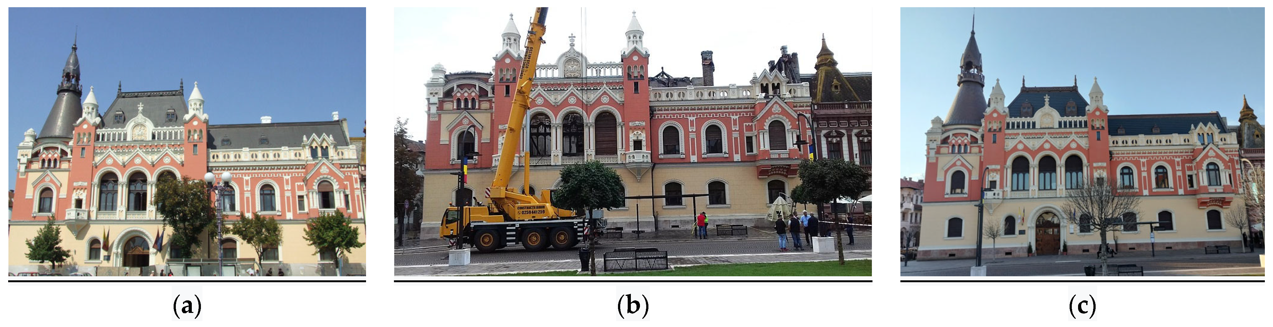
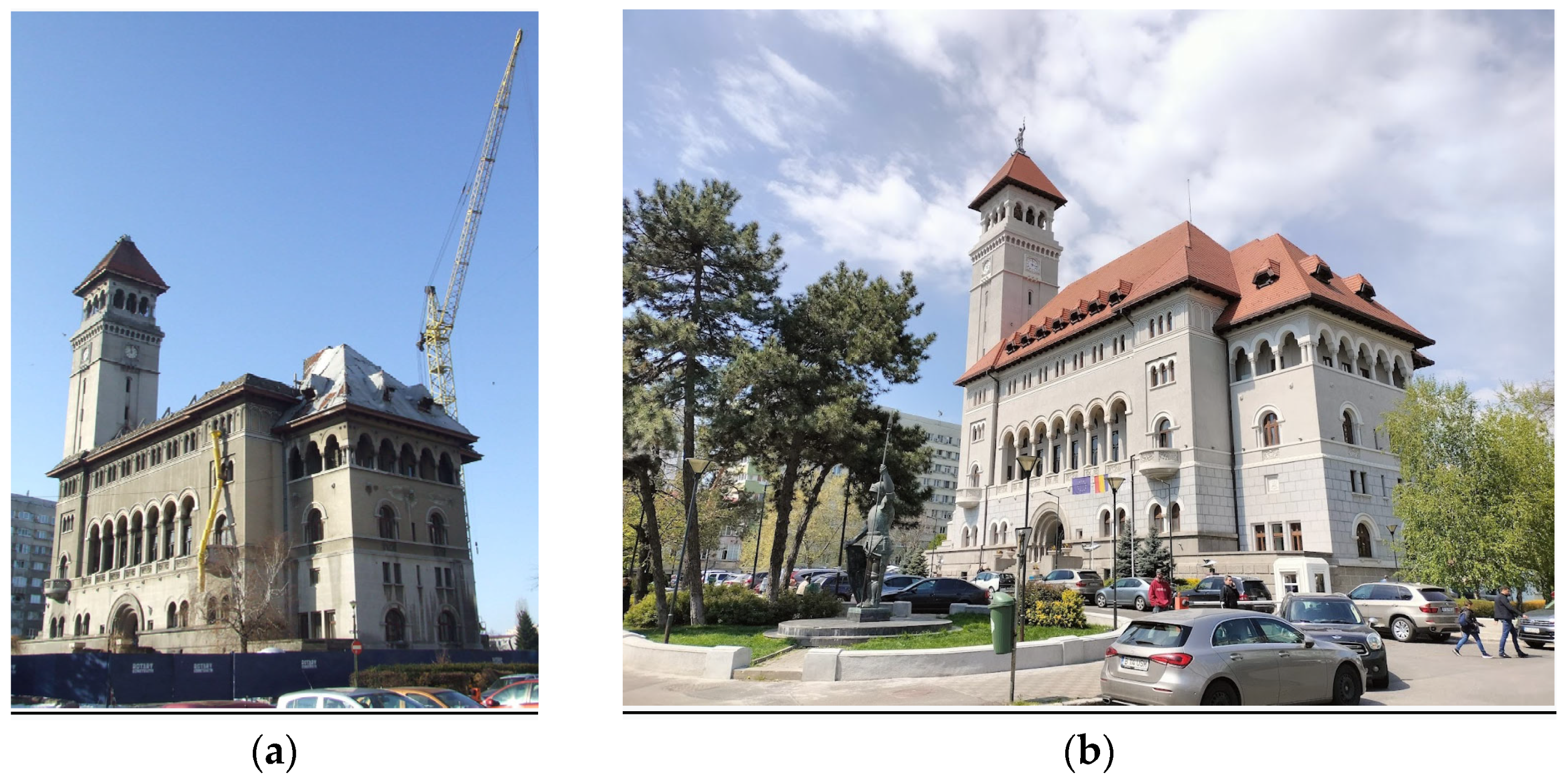
In the workshop sponsored by EGU in 2018 in Rome, the water was seen as both hazard and heritage. In the Hotel Gellert’s case study, the duality of this element could be seen in its spa heritage, which developed as a result of the karst thermal springs and the threat of floods from the Danube. The flood of 2013 was as strong as that of 1838, but the damage was not comparable, as, in the meantime, the course of the Danube River had been regularized.
In Târgu Mureș, another town representative of the art nouveau style, the course of the Mureș River was regularized after the floods of May 1970 and July 1975, among others.
As part of the project, as mentioned, research about the architect Richard Bordenache, who, after the floods of 1940, rebuilt the Corbeni village that is located in Argeș County, Romania, in the neo-Romanian national style, was performed.
Archival research was conducted at the Budapest archives for the Gellert Hotel, National archives for the Mureș floods of 1970 and Pitești archives for Corbeni village.
In addition, the relationship between architecture and water can be seen in various forms of structures, such as ports and harbours, thermal baths, and seaside architecture. Their insertion into and the roles they played in balneary localities is also a point of interest. These architecture programmes were vital during the 20th century and are integral to the analysis developed in the research.
In the early 20th century, work began on the Balnear development on the Black Sea. This area includes the modernist buildings of G.M. Cantacuzino in Eforie, the villas of Harry Goldstein (Horia Maicu) in Constanța [59] and also an early reinforced concrete example, in the case of the art nouveau Casino in Constanța, all in Romania (Figure 7). The Hennebique reinforced concrete system might be unsustainable, as the first author wrote in [60]. Examples of thermal baths in Herculane in the Carpathian Mountains of Romania are built in an art nouveau style that is combined with waterside architecture (Figure 8). Although all heritage buildings found in that area are in a dilapidated state, rendering them more vulnerable to natural hazards, the retrofit of Constanța’s casino is in the works. The retrofit project has the potential to bring about urban renewal. The early 20th century balnear development on the Adriatic Sea (Rimini) is another subject of investigation. In 2022, the Le Notre landscape forum—of which IMUAUP is a part—was held in that location and its topics dealt with climate change challenges in coastal areas [61]. Figure 9 presents interwar architecture in Rimini, Italy, and Figure 10 shows art nouveau architecture in the same place. The latter is a hotel favoured by film director Federico Fellini. A former consortium cultural project that included IMUAUP, considered water as heritage in four European locations: Brăila, on the lower Danube in Romania; in Coimbra, Portugal; in the Po delta in Comacchio, Italy; and on the coast and in Lille, France [62]. A relevant aquarium, an example of an interwar building converted to this function, is found in Cattolica, in the Emilia Romagna region. Figure 11 presents interwar architecture in Forli, Italy. This city is part of the ATRIUM cultural route in Emilia Romagna. Examples of thermal baths from the architecture of totalitarian regimes of the 20th century in Europe’s urban memory (ATRIUM) cultural route in this area are Castrocaro Terme e Terra del Sole, Bertinoro and Fratta Terme “thermal town between rationalism and Roman inspiration”; Cervia in the Po delta, “from “town of salt” to holiday destination”; and Cesenatico, on the coast, the “town of holiday camps”.

3.1.3. Fire Element

The town of Alesund in Norway was built in the art nouveau style after it was destroyed by fire (similar to the case of Corbeni village) with the art nouveau heritage continuing to be affected by fires. In Glasgow, for example, The International Council on Monuments and Sites (ICOMOS) is now developing (2023) guidelines for this particular hazard. The same situation occurs in Romania, where there were art nouveau buildings (e.g., the Greek-Catholic bishopric in Oradea was burnt down on 25 August 2018, Figure 12) and neo-Romanian buildings—their pendants—affected by the fire (e.g., the Banu Manta town hall in Bucharest, Figure 13).

3.2. Results of the Ontology Study

Up to this point, three ontology lines have been followed. The ontology of catastrophe photography, previously developed through a Marie Curie reintegration grant, has now been refine. Secondly, an ontology of zoning, in the floor plan of interwar buildings, relevant for earthquakes, was also previously developed, and is now undergoing a process involving the (Horizon) Results Booster and will benefit from a larger dissemination and exploitation. Thirdly, the ontology of decision is based on a process that was started during the doctorate period of the principal investigator. This translated into a decision tree, also developed for earthquakes, that concerned Romanian and Italian buildings in the modernist style. Previous research done in Rome by the PI, when the focal point was on the architecture of pioneer women during Modernism and water both as hazard and as heritage led to a connection, water and architecture, now also relevant for the research related to the architect Bordenache, as he was former fellow who studied in the same place in Rome and may be extended for Florence. An ontology for fire has been developed, considering a review of existing ontologies, following a two-part format comprising a building and its surrounding nature.
Using a photo database, an image annotation, according to macro-elements used to create 3D models, was proposed to be used for the investigation of buildings’ architecture. This annotation would be used to create a typical spatial model of the buildings of a specific time, found in various European locations. The buildings were subdivided into macro-elements according to the method of Lagomarsino and Giovinazzi [63], in order to determine possible collapse mechanisms in case of earthquakes. Podestà and Romano [64] continued the research of the CA’REDIVUS’ project, with a PhD, using this method. Previously, the vulnerability of buildings was evaluated in Romania according to a score related to certain characteristics. The spatial model can be translated into a simplified 3D model for annotation (e.g., for modernist buildings in Bucharest, Marcel and Iuliu Iancu and their formal alphabet [65,66]). Image annotation and maps were also created in this phase and can be used in a combined way using “timelines” (useful tools for this are ImagePlot, Netline [67], and Palladio).

3.3. Results of Innovative Mapping

First, Arcgis story maps were used—the San Francisco earthquake is an example of a classic story map (https://arcg.is/1mq5ja, accessed on 5 February 2024). In the Quake Museum in Lisbon, the Californian hazard is simulated through an installation based on a shaking table. The San Francisco earthquake is relevant through the “bracing for disaster” [68] approach, which may be relevant for the decision in Stage 3, as well as base isolation. This method of retrofitting was used for the San Francisco City Hall, built in 1915 as a replacement for the building destroyed during the 1906 earthquake (Figure 14c). This landmark was damaged in 1989 during the Loma Prieta earthquake and was refurbished after 1995 using this method (https://sfgov.org/cityhall/city-hall-restoration-project, accessed on 5 February 2024). In Bucharest the neo-Romanian national style was asserted in correspondence with art nouveau. One example of this is the Bucharest City Hall (Figure 14a,b), which was recently retrofitted through base isolation (2010–2016, engineer Adrian Iordăchescu). The base isolation method was presented at the DISASTERPROTECT [22] IMUAP conference in 2021 (https://www.uauim.ro/en/research/disasterprotect/, accessed on 5 February 2024), which laid the foundations of the research strategy in which this project is included. The Romanian solution originates from the process of translating centuries-old churches in order to save them from the Ceaușescu demolitions in the 1980s (solution put into place by engineer Eugen Iordăchescu). Through the work of Rudolf Fränkel, further research on Romanian and US architecture interference has been carried out, and this also includes the interwar works of the architect Haralamb Georgescu, who was, at the same time, active in designing and building in California.
Following the story map example of San Francisco, two further contemporary types of digital maps have been used: Google MyMaps and story maps. For the latter, three different software solutions have been tested: ArcGIS online story maps (currently, the classic version, though the new version is envisaged to be used as well), Knightlab story maps and the FRUCHT software. All of these digital tools for story maps allow integration with walking tours. Other walking tour software is being investigated (Pocket Guide, for mobiles). The walking tour is a method mentioned in the repository of “Writing Urban Places” [69]. Apart from the use of software, other narrating methods are additionally being explored. These are being connected to the issue of scenography, also followed in the Portuguese “Quake” Museum. Moreover, apart from the current project-designed story maps, there are existing tours in the cities of Bucharest and Lisbon pertaining to the earthquakes that the cities experienced.
As previously mentioned, work has been undertaken on defining the mapping structure for the database definition. Thus, the maps elaborated by Nolli (18th century) [70,71], Lynch [72], psychogeography [73,74], Caniggia [75] and Muratori [76,77] (Cataldi [78]) were investigated as prerequisites for the elaboration of maps in our project that utilized digital means (for instance, zooming in and out from landmarks to the general plan of common buildings, possible at different levels of detail). Several story maps were created (e.g., for architects Marcel and Iuliu Iancu). The investigative methods mentioned above serve a method by which a story can be approached with a map. Grid analysis (spatial syntax Hillier and Hanson [79]) will be adopted in order to analyse the correct position of buildings within cities. ORA (a toolkit for dynamic network analysis and visualization) [80] and Gephi will be used to connect the influences between the architecture of different countries after conducting a comparative analysis. These will allow the visualization of the network independent of the year, in the network historical social analysis. However, given the period in which the buildings were constructed, a chronology method will also be explored. Up to this point, the ORA and Gephi methods have been used to create the wildfire ontology.
As stated, The Trienal de Arquitectura de Lisboa was recently visited. There are some older connections to this event, in a previous edition of the Trienal, Romania’s interwar architecture was featured in 2016, an exhibition of relations between these styles and countries (Romania, Italy and Portugal) took place in 2019, while a recent IMUAUP PhD thesis was completed on Rationalisms of Southern Europe: The Case of Portugal [81]. Locally, the interwar style is referred to as “Modernism” or “Interbelic”, in opposition to the variant of the local national architecture, contemporary with art nouveau, which is recognized as the neo-Romanian Style. To some extent, it overlaps with the local Mediterranean style, with some architects designing projects in both ways, such as Tiberiu Niga. Currently, the undertaken research path involves various investigations through different areas in Lisbon and Bucharest using as methodology the combination of walkscape exploration and a rapid visual screening method to evaluate the heritage of Romanian modernist architecture. In 2024, these two case studies will be analysed in further depth and a third case is being documented. Two pathways regarding earthquake resilience have already been identified. One of these is in Bucharest—from the National Institute of Earth Physics, about the heritage of the protected built area of the Interwar Magheru Boulevard (Figure 15)—and the other is in Lisbon, in collaboration with Alexandre Costa, who led an interdisciplinary workshop in 2012 at the World Congress of Earthquake Engineering, where technical tours were carried out. These technical tours will be combined with maps of modernist architecture as well as the map of the effects of the 1755 earthquake based on the representation in azulejos—typical Portuguese ceramics—in an innovative method that will be developed in 2024 for mapping. Other objectives of past and future site visits are planned for museums related to the earthquake. An emphasis is placed on the rapid visual assessment method [82], for which the legislative framework was completed in Romania in 2022 [83]. This framework has an influence on the current and previous approaches to assessing the heritage of modernist architecture.
This research was detailed in [86]. The mapping structure was exemplified for the three detailed case studies that follow: Bucharest, Lisbon, and Rome.

4. Discussion

The purpose of the project “Future on the Past”, whose first results are presented in this paper, is to regionally map different characteristics of two early 20th century global styles: art nouveau and interwar. Namely, it is relevant how regional differences serve to render these buildings, otherwise vulnerable, more resilient to earthquake, flood or fire and, building on lessons from the vernacular and employing new construction techniques, reflect the way mass housing responds to the societal challenges associated with those days and to their peripheral locations. For earthquakes this is called “local seismic culture” [87], for flood and fire the research is still pioneering.
In the case of modernism, at the Docomomo conference in Ankara in 2006 these were called “other Modernisms”. For art nouveau this is not explicit, but some currents, for example the national romantic style in the Baltic states and Hungary, have their roots in vernacular architecture, as is the case with the early 20th century contemporary neo-Romanian style in Romania. Additionally, for modernism, a sea trip at the CIAM IV for Athens drew lessons from the Cyclades, and Adolph Loos was one of those adopting the white-washed geometric flat roofs of the Mediterranean in Greece. Similarly, in Romania, the architect Horia Creangă drew lessons from a similar vernacular shape, “culă” (kula manor)—a peasant fortification—from the Oltenia and Muntenia regions of southern Romania. These shapes proved to be more seismically resilient in the postwar 1956 Amorgos earthquake in the Cyclades. However, recent developments in Santorini housing have moved away from flat forms towards half cylinder roofs, which have a vital role in preserving dwellers’ lives in the case of wall collapse, in a local re-interpretation of the “triangle of life”. For earthquakes, beyond the foundation type and quality, the shape and layout of a floor plan also render vulnerabilities. For flood and fire the structural materials do count, but also the relationship to the surrounding landscape, the blue–green infrastructure, both in its connectedness or the lack thereof. For this reason, mapping represents an important feature in the project. As basis, the mapping begins with first-hand exploration through walkscapes, which contribute to the investigation of the technical resilience to disasters through rapid visual screening and to the investigation of psychological resilience through appropriation of the space in a heritage habitat [30]. This paper presents an example of mapping and several documentary images to exemplify the regional variations which may render buildings in a certain geographic area more vulnerable or more resilient. Based on the mentioned review of European projects, further work is planned to develop a checklist and to provide a taxonomy as basis for an ontology, in order to enhance the prioritization of retrofit interventions for buildings against flood and fire.
The project “Future on the Past” explores the various ways in which landscape and architectural heritage can be protected from environmental hazards through the use of retrofit solutions. The research focuses on elements of nature, such as water, air, fire, and earth, which have dual meanings. These are also seen in the mythology as archetypal landscape elements.

5. Conclusions and Future Work

The concept of the archetypal landscape is heavily influenced by the culture and philosophy of the local community that has adapted to the hazards. Additionally, there is a relationship between these two elements that determines, in turn, the integration in the urban–territorial context and landscape of a certain urban form.
The location of architectural heritage is often linked directly to the cultural and natural environment of the region. It can also go beyond its local characteristics and exceed its limitations due to existing local customs.
The archetypal philosophy was thus conceptualized as a component of an urban–architectural and semantic landscape construct, which was transposed in different and distinct situations.
The placement of architectural elements in an urban context was usually realized from a different perspective, namely from an urban morpho-structural point of view. This allowed it to avoid being framed in a problematic context related to environmental vulnerabilities. Other times, these elements were integrated into a site even if the location was not an easy one to build upon and carried the possibility of increased vulnerabilities (landslides, floods, fire, etc.). This was due to local custom and tradition.
Clearly, there is also the case wherein urbanization’s historical evolution has created various pressures on a site. These have been linked to evolutionary–temporal changes and transformations, including those related to the transformations of the urban framework and climate change. As a result, the initial urban architectural context has undergone a transformation, into a new one, with vulnerabilities increasing due to natural disasters and seismic activities.
In the future, a decision system design is planned. The decision will envisage the development of alternative retrofit methods for selected tier 1 cities and group those cities which have been photographically documented already into a second tier of cities, according to the research that has already been undertaken. For instance, in the case of earthquakes, this would mean adapting a bracing system to contemporary areas, such as energy dissipating braces, but also investigate RC braces which have been observed already in Bucharest. In cases of flood and fire hazard, the building itself plays a role, as does the urban pattern in which it is placed, including those that remain in a state of nature. As such, several relevant analyses have been conducted on the green areas of cities, in particular in Lisbon and in Vienna.

Author Contributions

Conceptualization, M.B.D.; methodology, M.B.D.; investigation, M.B.D., A.I. and M.P.; writing—original draft preparation, M.B.D., A.I., M.P. and C.C.; writing—review and editing, M.B.D., A.I. and M.P.; visualization, M.B.D. and A.I.; supervision, M.B.D. and C.C.; project administration, M.B.D. and A.I.; funding acquisition, M.B.D. All authors have read and agreed to the published version of the manuscript.

Funding

This research was funded by UEFISCDI, grant number PN-III-P4-PCE-2021-0609.

Data Availability Statement

At the end of the project we will have an online prototype of the database, and the database itself will be available offline on a dedicated computer in the “Ion Mincu” University of Architecture and Urban Planning.

Conflicts of Interest

The authors declare no conflict of interest. The funders had no role in the design of the study; in the collection, analyses, or interpretation of data; in the writing of the manuscript; or in the decision to publish the results.

References

  1. Johnson, B.A.; Kumar, P.; Okano, N.; Dasgupta, R.; Shivakoti, B.R. Nature-based solutions for climate change adaptation: A systematic review of systematic reviews. Nat. Based Solut. 2022, 2, 100042. [Google Scholar] [CrossRef]
  2. Li, Y.; Wang, G.; Chen, T.; Zhang, R.; Zhou, L.; Yan, L. Nature-Based Solutions in “Forest–Wetland”, Spatial Planning Strategies to Promote Sustainable City Development in Tianjin, China. Land 2022, 11, 1227. [Google Scholar] [CrossRef]
  3. Legutko-Kobus, P.; Nowak, M.; Petrisor, A.-I.; Bărbulescu, D.; Craciun, C.; Gârjoabă, A.-I. Protection of Environmental and Natural Values of Urban Areas against Investment Pressure: A Case Study of Romania and Poland. Land 2023, 12, 245. [Google Scholar] [CrossRef]
  4. Masiero, M.; Biasin, A.; Amato, G.; Malaggi, F.; Pettenella, D.; Nastasio, P.; Anelli, S. Urban Forests and Green Areas as Nature-Based Solutions for Brownfield Redevelopment: A Case Study from Brescia Municipal Area (Italy). Forests 2022, 13, 444. [Google Scholar] [CrossRef]
  5. Biasin, A.; Masiero, M.; Amato, G.; Pettenella, D. Nature-Based Solutions Modeling and Cost-Benefit Analysis to Face Climate Change Risks in an Urban Area: The Case of Turin (Italy). Land 2023, 12, 280. [Google Scholar] [CrossRef]
  6. Geneletti, D.; Cortinovis, C.; Orta-Ortiz, M.S.; Kato-Huerta, J.; Longato, D.; Falco, E. Mainstreaming Nature-Based Solutions in Cities Through Performance-Based Planning: A Case Study in Trento, Italy. In Nature-Based Solutions for Sustainable Urban Planning. Contemporary Urban Design Thinking; Mahmoud, I.H., Morello, E., Lemes de Oliveira, F., Geneletti, D., Eds.; Springer: Cham, Switzerland, 2022. [Google Scholar]
  7. Zuccaro, G.; Perelli, F.L.; De Gregorio, D.; Masi, D. CAESAR II: An Italian Decision Support Tool for the Seismic Risk. The Case Study of Torre Pellice, Villar Pellice and Pinerolo Municipalities. In Proceedings of the COMPDYN 2021 8th ECCOMAS Thematic Conference on Computational Methods in Structural Dynamics and Earthquake Engineering, Athens, Greece, 28–30 June 2021. [Google Scholar]
  8. Di Pirro, E.; Mendes, R.; Fidélis, T.; Sallustio, L.; Roebeling, P.; Marchetti, M.; Lasserre, B. The Embeddedness of Nature-Based Solutions in the Recovery and Resilience Plans as Multifunctional Approaches to Foster the Climate Transition: The Cases of Italy and Portugal. Land 2022, 11, 1254. [Google Scholar] [CrossRef]
  9. Di Salvatore, S.; Magatti, G.; Acciarri, M.; Rossetti, M.; Pereira da Costa, L.; Ribeiro, I. Solid Waste Management Approach at the University through Living Labs and Communication Strategies: Case Studies in Italy and Portugal. Sustainability 2022, 14, 5240. [Google Scholar] [CrossRef]
  10. Batista, T.; Barros, R.; Domínguez, J.F.; Cuevas, R.M.; Ruiz, J.S.; Casado, S.T. Climate Change Adaptation of Buildings Using Nature-Based Solutions: Application in Alentejo Central—LIFE myBUILDINGisGREEN. In New Metropolitan Perspectives. NMP 2022; Lecture Notes in Networks and Systems; Calabrò, F., Della Spina, L., Piñeira Mantiñán, M.J., Eds.; Springer: Cham, Switzerland, 2022; Volume 482, pp. 1658–1663. [Google Scholar]
  11. Silva Dantas, G.; Báthoryné Nagy, I.R. Green Infrastructure Enhancing Urban Resilience: Parallels between Vienna and Budapest. In Proceedings of the Fábos Conference on Landscape and Greenway Planning, Budapest, Hungary, 30 June–3 July 2022. [Google Scholar]
  12. Ben Salem, S.; Li, H.; Simon, M.; Jombach, S. Urban Green Infrastructure in the historical cores of Budapest and Vienna. In Proceedings of the SZIEntific Meeting of Young Researchers, Budapest, Hungary, 7 December 2020. [Google Scholar]
  13. Dantas, G.S.; da Silva, B.M.D.; Rosa, C.A.P.; Pereira, M.S. Green Infrastructure Reframing Historical Courtyards: Enhancing Urban Resilience in Budapest. In Challenges of Nowadays in the Light of Sustainability. Proceedings of the 8thVUA YOUTH Scientific Session; Magda, R., Ed.; Hungarian University of Agriculture and Life Sciences: Budapest, Hungary, 2021; pp. 53–59. [Google Scholar]
  14. Al Sayah, M.J.; Versini, P.-A.; Schertzer, D. H2020 projects and EU research needs for nature-based adaptation solutions. Urban Clim. 2022, 44, 101229. [Google Scholar] [CrossRef]
  15. Ibric, A. Innovative Materials and Systems for the Built Environment Funded by EU Programs. Argument 2022, 14, 270–296. [Google Scholar] [CrossRef]
  16. Thompson, A.; Bunds, K.; Larson, L.; Cutts, B.; Hipp, J.A. Paying for nature-based solutions: A review of funding and financing mechanisms for ecosystem services and their impacts on social equity. Sustain. Dev. 2023, 31, 1991–2066. [Google Scholar] [CrossRef]
  17. Nickayin, S.S.; Jahelka, A.; Ye, S.; Perrone, F.; Salvati, L. Planning for Just Cities with Nature-Based Solutions: Sustainability and Socio-Environmental Inequalities in San José de Chamanga, Ecuador. Land 2023, 12, 604. [Google Scholar] [CrossRef]
  18. Di Pirro, E.; Roebeling, P.; Sallustio, L.; Marchetti, M.; Lasserre, B. Cost-Effectiveness of Nature-Based Solutions under Different Implementation Scenarios: A National Perspective for Italian Urban Areas. Land 2023, 12, 603. [Google Scholar] [CrossRef]
  19. Rana, I.A.; Khaled, S.; Jamshed, A.; Nawaz, A. Social protection in disaster risk reduction and climate change adaptation: A bibliometric and thematic review. J. Integr. Environ. Sci. 2022, 19, 65–83. [Google Scholar] [CrossRef]
  20. Vojvodíková, B.; Tichá, I.; Starzewska-Sikorska, A. Implementing Nature-Based Solutions in Urban Spaces in the Context of the Sense of Danger That Citizens May Feel. Land 2022, 11, 1712. [Google Scholar] [CrossRef]
  21. Calliari, E.; Castellari, S.; Davis, M.; Linnerooth-Bayer, J.; Martin, J.; Mysiak, J.; Pastor, T.; Ramieri, E.; Scolobig, A.; Sterk, M.; et al. Building climate resilience through nature-based solutions in Europe: A review of enabling knowledge, finance and governance frameworks. Clim. Risk Manag. 2022, 37, 100450. [Google Scholar] [CrossRef]
  22. Bostenaru Dan, M.; Brastaviceanu, M.; Gociman, C.O.; Florescu, T.; Craciun, C.; Hărmănescu, M.; Iordăchescu, A.; Petrea, S.; Topalov, S.; Gacichevici, A.M.; et al. “Ion Mincu“ University of Architecture and Urbanism research strategy in the field of disaster for protection of natural and built heritage in urban and rural zones. In Proceedings of the EGU General Assembly 2022, Vienna, Austria, 23–27 May 2022. EGU22-665. [Google Scholar]
  23. Bostenaru Dan, M.; Ibric, A.; Popescu, M. Strategic decisions for retrofit of heritage buildings in different geographic areas of Europe. In Proceedings of the EGU General Assembly 2023, Vienna, Austria, 24–28 April 2023. EGU23-6703. [Google Scholar]
  24. Jiménez-Vicario, P.M.; Mestre-Martí, M.; Ródenas-López, M.A. Mediterranean Islands’ Vernacular Architecture and the Origin of Modern Architecture. In Digital Modernism Heritage Lexicon. Springer Tracts in Civil Engineering; Bartolomei, C., Ippolito, A., Vizioli, S.H.T., Eds.; Springer: Cham, Switzerland, 2022. [Google Scholar]
  25. Lejeune, J.-F.; Sabatino, M. Modern Architecture and the Mediterranean. Vernacular Dialogues and Contested Identities; Routledge: Abingdon, UK, 2010. [Google Scholar]
  26. Kelman, I. How can island communities deal with environmental hazards and hazard drivers, including climate change? Environ. Conserv. 2017, 44, 244–253. [Google Scholar] [CrossRef]
  27. Popescu, D. Pitoresc Mediteraneean în Arhitectura Bucureștiului Interbelic; Igloo: Bucharest, Romania, 2022. [Google Scholar]
  28. Puczkó, L.; Rátz, T. Trailing Goethe, Humbert and Ulysse. Cultural routes in tourism. In Cultural Tourism: Global and Local Perspective; Richard, G.S., Ed.; Routledge: Abingdon, UK, 2007; pp. 131–148. [Google Scholar]
  29. Sokolov, V.Y.; Wenzel, F.; Mohindra, R. Probabilistic seismic hazard assessment for Romania and sensitivity analysis: A case of joint consideration of intermediate-depth (Vrancea) and shallow (crustal) seismicity. Soil Dyn. Earthq. Eng. 2009, 29, 364–381. [Google Scholar] [CrossRef]
  30. Gociman, C.O. Managementul Reducerii Riscului la Dezastre. Strategii de Arhitectură și Urbanism; “Ion Mincu” Publishing House: Bucharest, Romania, 2006. [Google Scholar]
  31. Schenk, G. (Ed.) Katastrophen. In Vom Untergang Pompejis bis zum Klimawandel; Jan Thorbecke Verlag: Cologne, Germany, 2009. [Google Scholar]
  32. Wieczorek, A.; Schenk, G.J.; Juneja, M.; Lind, C. (Eds.) Mensch. Natur. Katastrophe. Von Atlantis bis Heute; Schnell & Steiner: Regensburg, Germany, 2014. [Google Scholar]
  33. Schenk, G. (Ed.) Historical Disaster Experiences. Transcultural Research–Heidelberg Studies on Asia and Europe in a Global Context; Springer: Cham, Switzerland, 2017. [Google Scholar]
  34. Norberg-Schulz, C. Genius Loci. Landschaft, Lebensraum, Baukunst; Klett-Cotta: Stuttgart, Germany, 1982. [Google Scholar]
  35. Crăciun, C. Garden in the Archetypal World and Cosmic Meaning. Philosophical and aesthetic sense, cosmological theories and garden archetypes. In Cultural Landscape and Development; Sârbu, C., Ed.; Editura Universitară “Ion Mincu”: Bucharest, Romania, 2011; pp. 163–180. [Google Scholar]
  36. Crăciun, C.; Stavinschi, M.; Stavinschi, A.-C. Cosmic art inspiration with the old Romanians. Rom. Astron. J. 2012, 22, 55–76. [Google Scholar]
  37. Gimbutas, M. The Goddesses and Gods of Old Europe. Myths and Cult Images; University of California Press: Oakland, CA, USA, 2007. [Google Scholar]
  38. Renfrew, C. The Early Copper and Tiszapolgár Culture in the Carpathian Basin. ByIda Bognár-Kutzián. 240pages, 74 plates, 1 separate map. Akadémiai Kiadó, Budapest, 1972. Proc. Prehist. Soc. 1973, 39, 474–475. [Google Scholar] [CrossRef]
  39. Marymor, L. Paleolithic Rock Art: A Worldwide Literature Survey Extracted from the Rock Art Studies Bibliographic Database for the Years 1864–2017. Arts 2018, 7, 14. [Google Scholar] [CrossRef]
  40. Bratianu, G.I. Une Enigme et un Miracle Historique: Le Peuple Roumain; KROYS: Bucharest, Romania, 1942. [Google Scholar]
  41. Eliade, M. The Sacred and Profane; Humanitas: Bucharest, Romania, 2016. [Google Scholar]
  42. Crăciun, C. Evolutionary Biophilic Concerns in the Landscape and the Relationship with the Future Consciousness Society. In Architecture Inspired by Nature; Cervera Sardá, M.R., Dușoiu, E.C., Lascu, T.N., Eds.; Springer: Cham, Switzerland, 2023. [Google Scholar]
  43. Liritzis, I.; Westra, A.; Miao, C. Disaster geoarchaeology and natural cataclysms in world cultural evolution: An overview. J. Coast. Res. 2019, 35, 1307–1330. [Google Scholar] [CrossRef]
  44. Meier, M. Roman emperors and ‘natural disasters’ in the first century A.D. In Historical Disasters in Context; Janku, A., Schenk, G.J., Mauelshagen, F., Eds.; Routledge: New York, NY, USA, 2012; pp. 15–30. [Google Scholar]
  45. Sassu, M.; Cei, C. “Casa Torre” Construction: Multistory Tower Masonry with Stone Pillars and Wood or Arched Beams. World Housing Encyclopedia. 2005. Available online: https://www.world-housing.net/WHEReports/wh100110.pdf (accessed on 5 February 2024).
  46. Tsianaka, E. Evaluating the Sophistication of Vernacular Architecture to Adjust to the Climate. WIT Trans. Built Environ. 2006, 86, 9. [Google Scholar] [CrossRef]
  47. Bostenaru Dan, M.; Jianu, O. Totalitarianism and the emigration of a Romanian architect to the USA in the interwar era. In Creative Negotiations. Romania–America 1920–1940; Andraș, S., Mihaly, R., Eds.; Cluj University Press: Cluj, Romania, 2023; pp. 267–282. [Google Scholar]
  48. Langenbach, R. From “Opus Craticium” to the “Chicago Frame”: Earthquake-Resistant Traditional Construction. Int. J. Archit. Herit. 2007, 1, 29–59. [Google Scholar] [CrossRef]
  49. Crăciun, C. The Vulnerability of Fragile Landscape and Complex Hazards. In Earthquake Hazard Impact and Urban Planning. Environmental Hazards; Bostenaru Dan, M., Armas, I., Goretti, A., Eds.; Springer: Dordrecht, The Netherlands, 2014. [Google Scholar]
  50. Enache, C.; Crăciun, C. The Role of the Landscape in the Identity Generation Process. Procedia Soc. Behav. Sci. 2013, 92, 309–313. [Google Scholar] [CrossRef]
  51. Papina, C.; Crăciun, C. Nature—A Structural Component for Future Human Settlements? Biophilic City Approaches. In Architecture Inspired by Nature; Cervera Sardá, M.R., Dușoiu, E.C., Lascu, T.N., Eds.; Springer: Cham, Switzerland, 2023. [Google Scholar]
  52. Bassett, K. Walking as an Aesthetic Practice and a Critical Tool: Some Psychogeographic Experiments. J. Geogr. High. Educ. 2004, 28, 397–410. [Google Scholar] [CrossRef]
  53. Smith, P. Walking-Based Arts: A Resource for the Guided Tour? Scand. J. Hosp. Tour. 2013, 13, 103–114. [Google Scholar] [CrossRef]
  54. Willey, D. A Walk about Rome: Tactics for mapping the urban periphery. Archit. Theory Rev. 2009, 15, 9–21. [Google Scholar] [CrossRef]
  55. Federal Emergency Management Agency (FEMA). FEMA 155 (ATC-21-1): Rapid Visual Screening of Buildings for Potential Seismic Hazards: Supporting Documentation; Applied Technological Council (ATC): Washington, DC, USA, 1988. [Google Scholar]
  56. Deleuze, G.; Guattari, F. Mille Plateaux; Éditions de Minuit: Paris, France, 1980. [Google Scholar]
  57. Alexander, C.; Isikawa, S.; Silverstein, M. A Pattern Language; Oxford University Press: New York, NY, USA, 1977. [Google Scholar]
  58. Pfammatter, U. Die Erfindung des Modernen Architekten: Polytechnische und Industrielle Ausbildung für Architekten und Ingenieure–ein Kapitel Baugeschichte; Birkhäuser Verlag: Zürich, Switzerland, 1997. [Google Scholar]
  59. Hasnaș, D.; Cel Mare, A.; Criticos, M.; Cornescu, R.; Plăiașu, C. Goldstein Maicu. Vilele Moderne. Constanța. 1931–1940; Hasnaș, D., Ed.; “Ion Mincu” Publishing House: Bucharest, Romania, 2022. [Google Scholar]
  60. Bostenaru Dan, M. Building the Future on Lessons of Historic Reinforced Concrete. Sustainability 2020, 12, 5925. [Google Scholar] [CrossRef]
  61. de Vries, J. (Ed.) LE:NOTRE Landscape Forum 2022. ‘Dancing to the Future’. 26–30 April 2022; LE:NOTRE Landscape Monographs, nr. 4.; LE:NOTRE Institute: Wageningen, The Netherlands, 2022. [Google Scholar]
  62. Peixoto, P.; Cardielos, J.P. A Água Como Património. Experiências de Requalificação das Cidades com água e das Paisagens fluviais; Imprensa da Universidade de Coimbra: Coimbra, Portugal, 2016. [Google Scholar]
  63. Lagomarsino, S.; Giovinazzi, S. Macroseismic and mechanical models for the vulnerability and damage assessment of current buildings. Bull. Earthq. Eng. 2006, 4, 415–443. [Google Scholar] [CrossRef]
  64. Podestà, S.; Romano, C. A Macroseismic Method for Vulnerability Assessment of Rationalist Architectural Heritage. Procedia Econ. Financ. 2014, 18, 173–180. [Google Scholar]
  65. Ioan, A. Marcel Iancu și alfabetul său formal: Un exercițiu didactic în derulare (I). Arhitectura 2012, 3, 22. [Google Scholar]
  66. Ioan, A. Marcel Janco Reloaded. Arhitectura 2022, 5–6, 208–219. [Google Scholar]
  67. Caquard, S. StoryMaps & Co. The state of the art of online narrative cartography. Mappe Monde 2017, 121. [Google Scholar] [CrossRef]
  68. Tobriner, S. Bracing for Disaster: Earthquake-Resistant Architecture and Engineering in San Francisco 1838–1933; Heyday Books: Berkeley, CA, USA, 2006. [Google Scholar]
  69. Machado e Moura, C.; Milián Bernal, D.; Restrepo Restrepo, E.; Havik, K.; Niculae, L. (Eds.) REPOSITORY 49. Methods and Assignments for Writing Urban Places; Nai 010 Publishers: Rotterdam, The Netherlands, 2023. [Google Scholar]
  70. Tice, J.; Steiner, E.; Ceen, A. Nolli Map of Rome|InfoGraphics Lab. 2005. Available online: https://infographics.uoregon.edu/projects/pastprojects/nolli/ (accessed on 10 October 2023).
  71. Tice, J.; Steiner, E.; Ceen, A.; Camerlenghi, N.; Svevo, G.; Student Research Team. Interactive Nolli Map Website. 2021. Available online: https://web.stanford.edu/group/spatialhistory/nolli/ (accessed on 10 October 2023).
  72. Lynch, K. The Image of the City; MIT Press: Cambridge, MA, USA, 1960. [Google Scholar]
  73. Debord, G. Introduction to a Critique of Urban Geography. In Situationist International; Knabb, K., Ed.; Bureau of Public Secrets: Berkeley, CA, USA, 1955. [Google Scholar]
  74. Debord, G. La Societé du Spectacle; Editions Champ Libre: Paris, France, 1967. [Google Scholar]
  75. Caniggia, G. Lettura di Firenze–Strukturanalyse der Stadt Florenz. In Die Morphologische Betrachtungsweise von Stadt und Territorium–L’Approche Morphologique de la Ville Et du Territoire; Malfroy, S., Caniggia, G., Eds.; ETH, Lehrstuhl f. Städtebaugeschichte: Zürich, Switzerland, 1986. [Google Scholar]
  76. Muratori, S. Studi per una Operante Storia Urbana di Venezia; Instituto Poligrafico dello Stato Libreria dello Stato: Rome, Italy, 1960; pp. 97–208. [Google Scholar]
  77. Muratori, S. Studi per una Operante Storia Urbana di Roma; Consiglio Nazionale delle Ricerche: Rome, Italy, 1963. [Google Scholar]
  78. Cataldi, G.; Maffei, G.L.; Vaccaro, P. Saverio Muratori and the Italian school of planning typology. Urban Morphol. 1997, 6, 3–14. [Google Scholar] [CrossRef]
  79. Hillier, B.; Hanson, J. The Social Logic of Space; Cambridge University Press: Cambridge, UK, 1984. [Google Scholar]
  80. Carley, K.M. ORA: A Toolkit for Dynamic Network Analysis and Visualization. In Encyclopedia of Social Network Analysis and Mining; Alhajj, R., Rokne, J., Eds.; Springer: New York, NY, USA, 2014; p. 1219. [Google Scholar]
  81. Savonea, G. Raționalisme ale Sudului European. Cazul Portugaliei; Editura Universitară “Ion Mincu”: Bucharest, Romania, 2023. [Google Scholar]
  82. Bostenaru Dan, M. Interpreting the Photographical Information Stored in Multimedia GIS. In Ergebnisse aus dem Interfakultativen Graduiertenkolleg Naturkatastrophen. Zusammenstellung Ausgewählter Veröffentlichungen und Forschungsberichte 1998 bis 2002; Plapp, T., Hauck, C., Jaya, M., Eds.; Forschungsberichte GK Naturkatastrophen, University of Karlsruhe: Karlsruhe, Germany, 2003; Volume 1, pp. 93–105. [Google Scholar]
  83. Parlamentul României. Lege nr. 212 din 12 Iulie 2022 Privind Unele Măsuri Pentru Reducerea Riscului Seismic al Clădirilor. Monitorul Oficial 2022. 708. Available online: https://legislatie.just.ro/Public/DetaliiDocument/257526 (accessed on 5 February 2024).
  84. Bostenaru Dan, M. Multidisciplinary co-operation in building design according to urbanistic zoning and seismic microzonation. Nat. Hazards Earth Syst. Sci. 2005, 5, 397–411. [Google Scholar] [CrossRef]
  85. Lungu, D.M.; Scherer, R.J.; Zsohar, M.; Coman, O. On the Phenomenon of Long Periods of Ground Vibration During the 1990, 1986 and 1977 Earthquake Records from Vrancea Source. In Earthquake Resistance Construction and Design 1; Savidis, S.A., Balkema, A.A., Eds.; Routledge: Rotterdam, The Netheralnds, 1994; pp. 51–59. [Google Scholar]
  86. Bostenaru Dan, M.; Ibric, A. Mapping perception. Innovative digital mapping approaches as urban investigation methods. Argument 2023, 15, 209–232. [Google Scholar] [CrossRef]
  87. Hărmănescu, M.; Georgescu, E.S. Case study: Local seismic culture in Romanian vernacular architecture. In Seismic Retrofitting: Learning from Vernacular Architecture; Correia, M.R., Lourenco, P.B., Varum, H., Eds.; Taylor & Francis: London, UK, 2016. [Google Scholar]
Figure 1. Vernacular origins of modernism in the Mediterranean: (a) burnt residential hill on Paros Island, Cyclades Greece, showing island vulnerability [26], photo A. Ibric, 2022. (b) Haus Rufer, arch. Adolf Loos, 1922, Vienna, Austria, the first example of Raumplan, photo: M. Bostenaru, 2010.
Sustainability 16 01505 g001
Figure 2. Vernacular origins of modernism in Romania. (a) Cula Duca, (b) house belonging to Richard Bordenache in Corbeni, (c) “Patria” block of flats by Horia Creangă, (d) cula Bujoreni (bare stone masonry work), (e) power station in Sinaia by Duiliu Marcu, photos: M. Bostenaru, 2002, 2017, 2023.
Sustainability 16 01505 g002
Figure 3. Overview of the methodology.
Sustainability 16 01505 g003
Figure 4. Examples of perspective, floor plan, facade and section drawings: (a) Athenee Palace, after its modernist refurbishment, was one of the first buildings in reinforced concrete in Bucharest, perspective, arch. Duiliu Marcu (1935–1937); (b) Adriatica building, based on a steel structure, floor plan, arch. Rudolf Frankel (1933–1935); (c) Ambassador Hotel, facade, arch. and owner Arghir Culina (1939); (d) Tinerimea Româna Palace, section, arch. Virginia Haret (1924–1927), copy drawing in the typical ozalid technique from before the 1930s. Drawing reproduction sources, (ac) Bucharest Town Hall Archive and (d) National Archives, Bucharest Office.
Sustainability 16 01505 g004
Figure 5. (a) Cifra ház Kecskemét, Hungary, arch. Géza Márkus 1902, Secession style, Earthquake 1911; (b) 1940 flood reconstruction in Corbeni, Romania, arch. Richard Bordenache, neo-Romanian architectural style. Photos: M. Bostenaru, 1999, 2012.
Sustainability 16 01505 g005
Figure 6. Activity of arch. Richard Bordenache: (a) Antonești planned village in Corbeni Commune, Argeș county—house plan (upper left), photograph (lower left), facade (lower centre) and situation plan of the central square (upper centre); (b) cost estimate of the planned buildings for the houses in the Antonesti village; (a,b) sources from the Argeș County Archives in Pitești; (c) report from arch. Bordenache as scholarship holder and its host, The Emil Panaitescu (1910–1955) Fund from the National Archives of Romania, about the Accademia di Romania in Rome.
Sustainability 16 01505 g006
Figure 7. Early reinforced concrete art nouveau casino, arch. Daniel Renard and Petre Antonescu, 1905–10, Constanta, Romania, photo A. Balaceanu, used with permission.
Sustainability 16 01505 g007
Figure 8. (a) Art nouveau Hotel Dacia, arch. Guido Hoepfner & Géza György, 1906; (b,c) “Neptun” baths, 1883–86, waterside architecture, now subject of a monument save action. Herculane, Romania, photos M. Bostenaru, 2008.
Sustainability 16 01505 g008
Figure 9. Interwar architecture on the seashore in Rimini, Italy: Nettuno restaurant, arch. Massimo Morandi, 1933, photo: M. Bostenaru, 2022. (a) eye level view; (b) aerial view.
Sustainability 16 01505 g009
Figure 10. Art nouveau architecture near the sea, Rimini, Italy: Grand Hotel, arch. Paolo Somazzi, 1908, photo: M. Bostenaru, 2022. (a) exterior; (b) interior.
Sustainability 16 01505 g010
Figure 11. Interwar architecture in Forli, Italy, regional characteristics. (a) Post office building—Palazzo Poste e Telegrafi, arch. Cesare Bazzani, 1931–1932; (b) former Casa del Balilla, today former GIL building, arch. Cesare Valle, 1933–35, Photos: M. Bostenaru, 2022.
Sustainability 16 01505 g011
Figure 12. The fire from 25 August 2018 affecting the palace of the Greek-Catholic bishopric in Oradea, Romania, arch. Kálmán Rimanóczy Jr. (1903–1905), eclectic style, including art nouveau. (a) Photograph from 2009, before the fire, by Maria Bostenaru; (b) photograph the day after the fire, photo by Szatmári Tivadar; (c) photograph from 2023, after the reconstruction, by Maria Bostenaru.
Sustainability 16 01505 g012
Figure 13. The city hall of sector 1 in Bucharest, arch. Nicu Georgescu and George Cristinel (1927–1938), in the neo-Romanian style, affected by fire. (a) Photograph in December 2009, immediately after the fire and (b) photograph from 2003, after restoration. Photos: M. Bostenaru.
Sustainability 16 01505 g013
Figure 14. Seismic zone buildings with base isolation, from the early 20th century: (a) 2002 main view of Bucharest City Hall (1906–1910), arch. Petre Antonescu; (b) 2023 view of the refurbished Bucharest City Hall, with base isolation; and (c) San Francisco City Hall (1913–1915), arch. Arthur Brown jr., photograph taken in 2006; images sources Maria Bostenaru-Dan.
Sustainability 16 01505 g014
Figure 15. Cooperation map regarding architecture and engineering and taking into account liquefaction for interwar buildings in Bucharest, Romania, after [84]. (a) Webmap, see https://arcg.is/Cuyyy, accessed 5 February 2024 and (b) story map, https://arcg.is/Xr4u4, accessed 5 February 2024. Lungu et al., 1994 [85].
Sustainability 16 01505 g015
Disclaimer/Publisher’s Note: The statements, opinions and data contained in all publications are solely those of the individual author(s) and contributor(s) and not of MDPI and/or the editor(s). MDPI and/or the editor(s) disclaim responsibility for any injury to people or property resulting from any ideas, methods, instructions or products referred to in the content.

