


Assessment of Yellow River Region Cultural Heritage Value and Corridor Construction across Urban Scales: A Case Study in Shaanxi, China


Abstract
1. Introduction
2. Materials and Methods
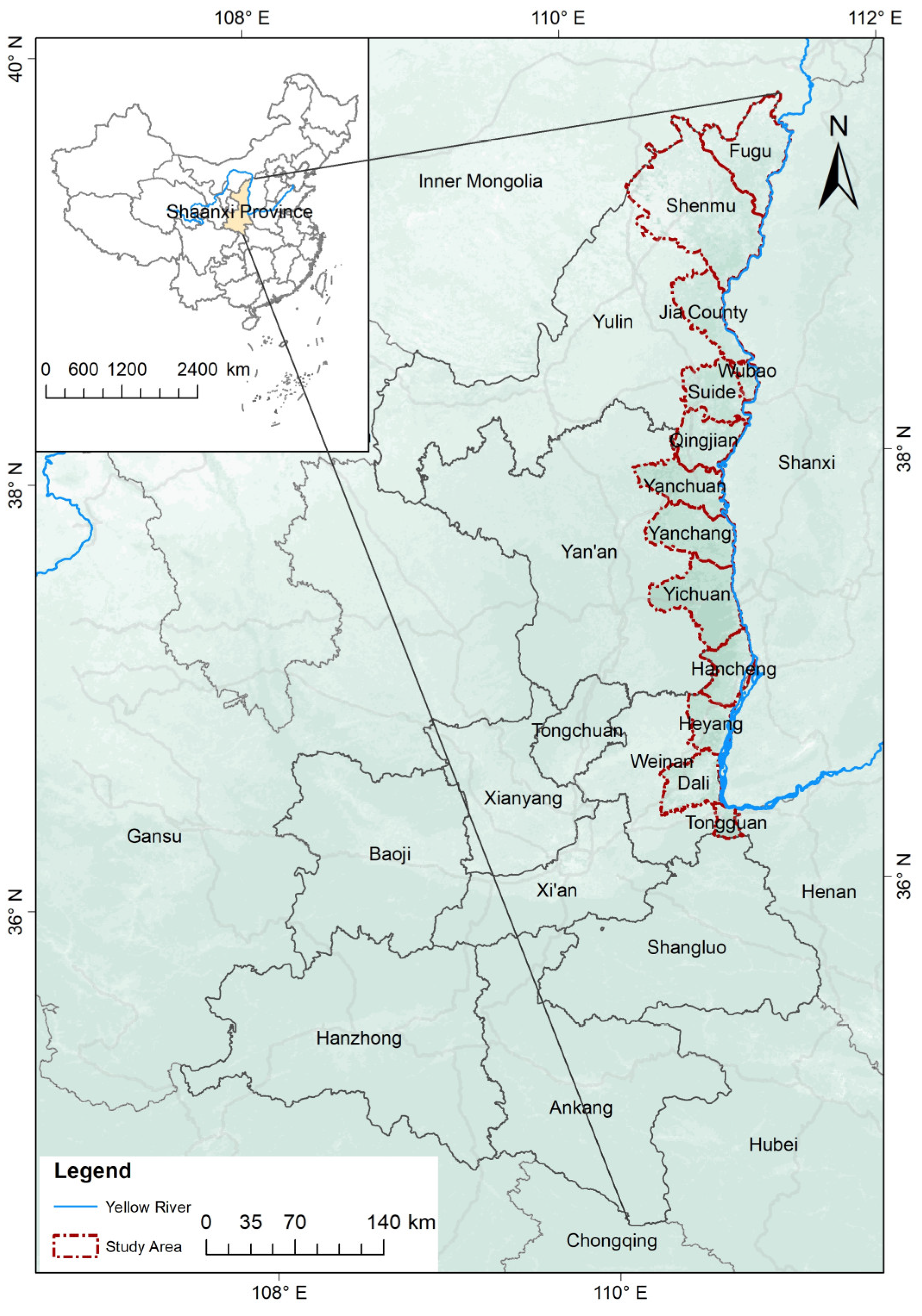
2.1. Study Area
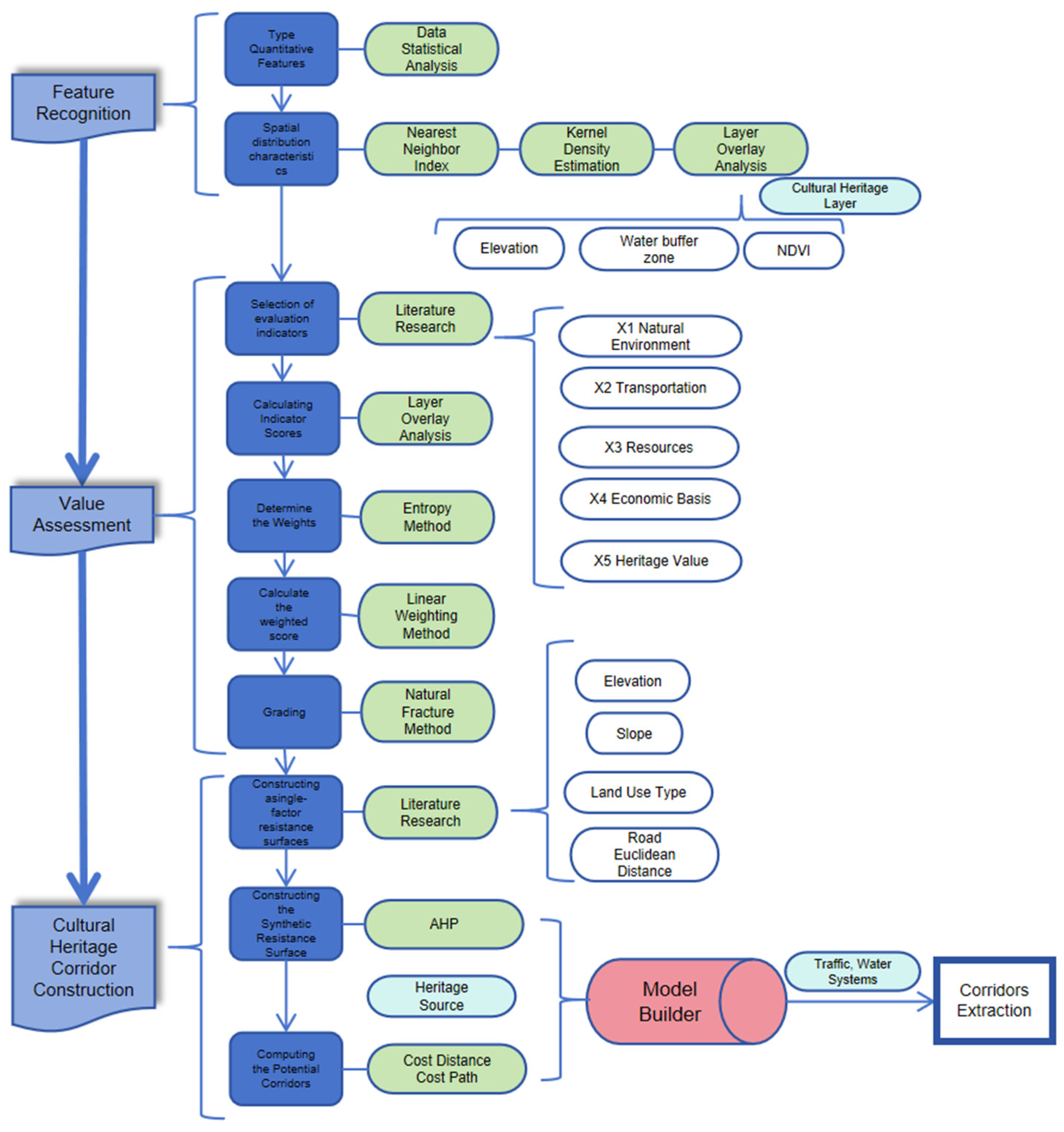
2.2. Research Framework
2.3. Research Methods
2.3.1. GIS Spatial Analysis Methods
- (1)
- Nearest neighbor index
- (2)
- Kernel density estimation
2.3.2. Entropy Method and Linear Weighting Method
2.3.3. Minimum Cumulative Resistance Model
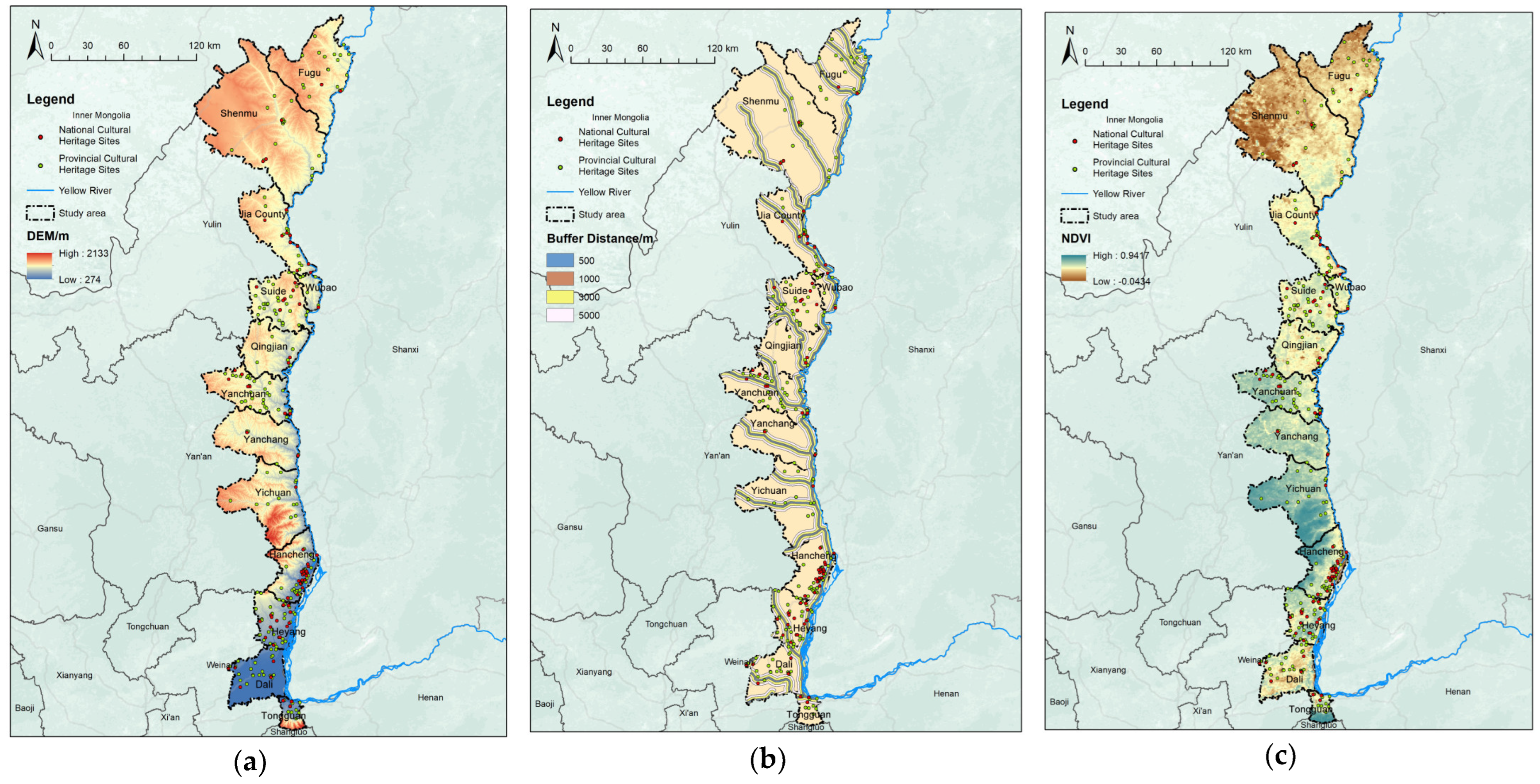
2.4. Data Sources
3. Results
3.1. Identification of the Characteristics of Cultural Heritage Resources
3.1.1. Type and Quantity Features
3.1.2. Spatial Distribution Characteristics
- (1)
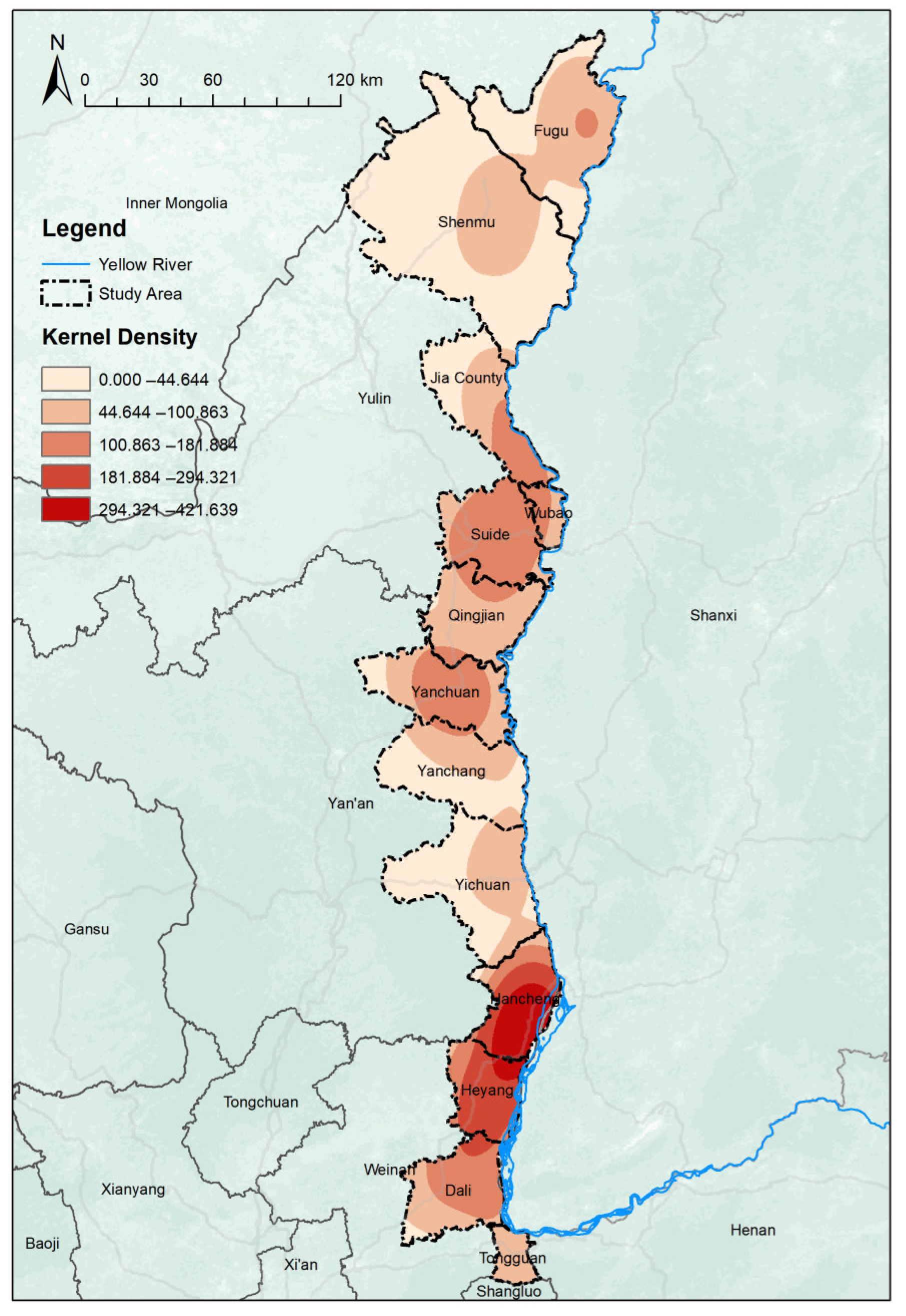
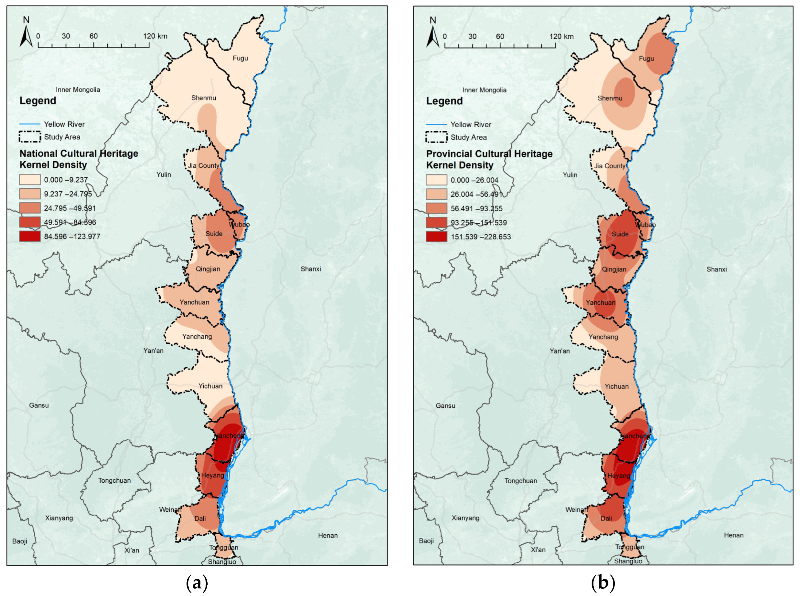
- Overall features
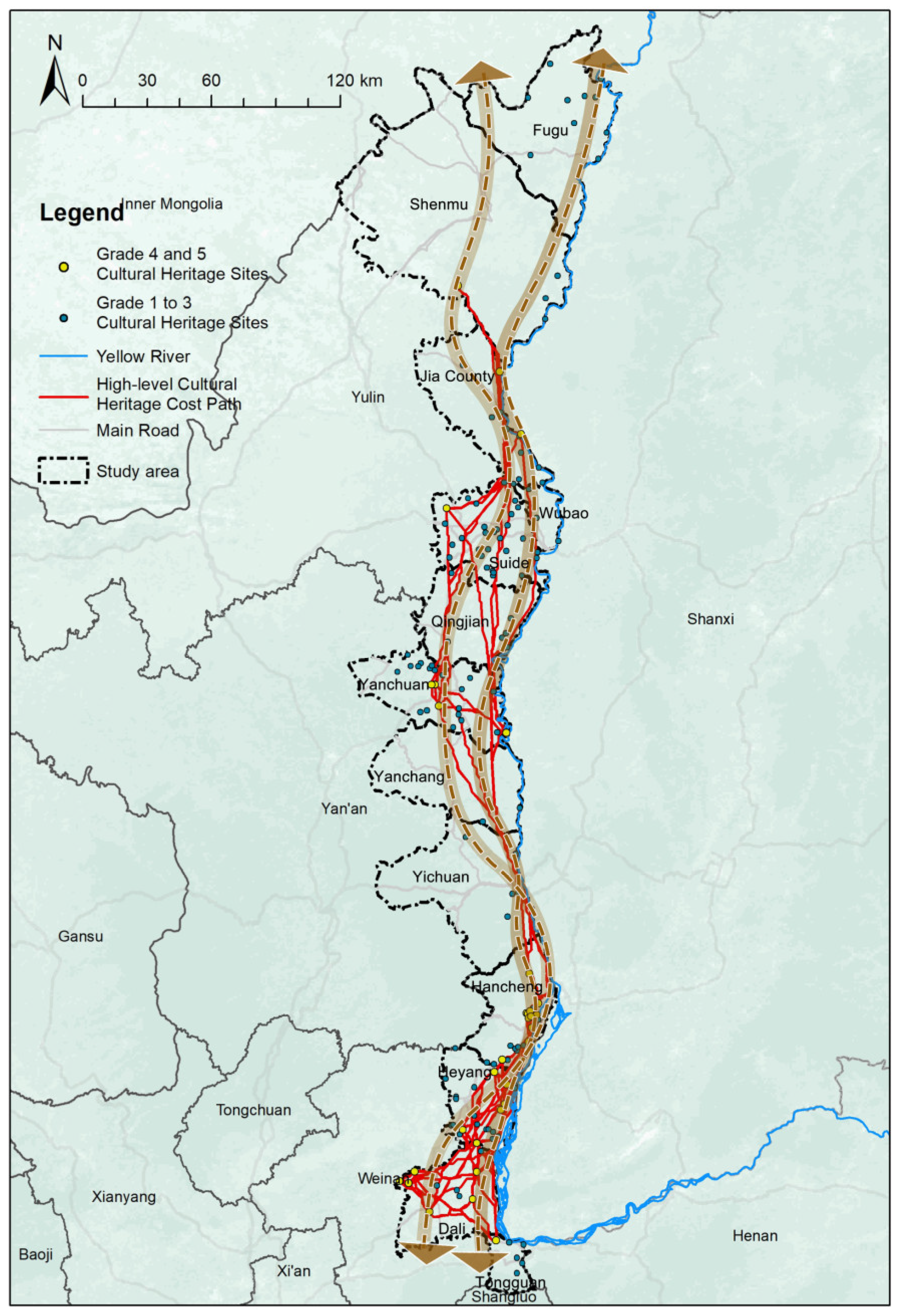
3.2. Extraction of Cultural Heritage Corridors
3.2.1. Assessment of Heritage Value
3.2.2. Extraction of Main Corridors
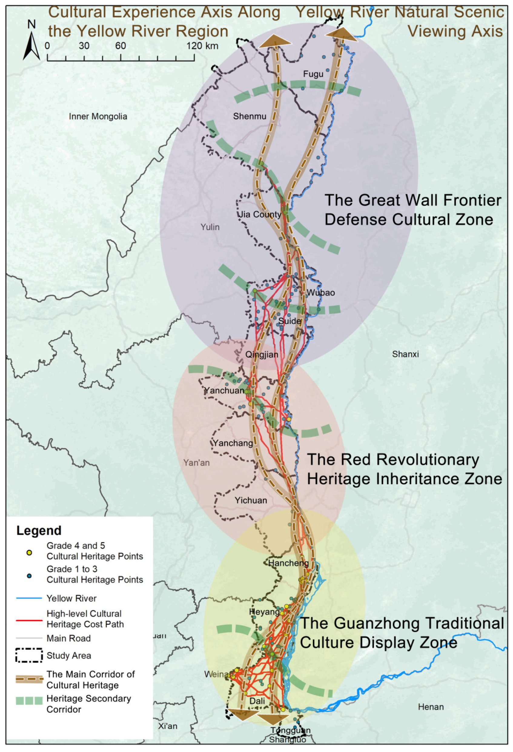
3.2.3. Construction of Conservation Patterns
4. Discussion
4.1. Approach for Constructing a Graded Corridor
4.2. Planning Strategies: Constructing Hierarchical Cultural Heritage Corridors across Urban Boundaries
4.3. Limitations
5. Conclusions
Author Contributions
Funding
Institutional Review Board Statement
Informed Consent Statement
Data Availability Statement
Conflicts of Interest
References
- Steward, J.H. The Concept and Method of Cultural Ecology. In Theory of Culture Change: The Methodology of Multilinear Evolution; University of Illinois Press: Urbana, IL, USA, 1977. [Google Scholar]
- Harrison, R. Beyond “Natural” and “Cultural” Heritage: Toward an Ontological Politics of Heritage in the Age of Anthropocene. Herit. Soc. 2015, 8, 24–42. [Google Scholar] [CrossRef]
- Little, C.E. Greenways for America; JHU Press: Baltimore, MD, USA, 1995. [Google Scholar]
- Boley, B.B.; Johnson Gaither, C. Exploring Empowerment within the Gullah Geechee Cultural Heritage Corridor: Implications for Heritage Tourism Development in the Lowcountry. J. Herit. Tour. 2016, 11, 155–176. [Google Scholar] [CrossRef]
- Svobodova, K.; Hajek, T. Pilgrimage Route Recovery in an Industrial Landscape. J. Environ. Plan. Manag. 2017, 60, 959–976. [Google Scholar] [CrossRef]
- Donohoe, H.M. Sustainable Heritage Tourism Marketing and Canada’s Rideau Canal World Heritage Site. J. Sustain. Tour. 2012, 20, 121–142. [Google Scholar] [CrossRef]
- Snowball, J.D.; Courtney, S. Cultural Heritage Routes in South Africa: Effective Tools for Heritage Conservation and Local Economic Development? Dev. South. Afr. 2010, 27, 563–576. [Google Scholar] [CrossRef]
- Winter, T. The Geocultural Heritage of the Silk Roads. Int. J. Herit. Stud. 2021, 27, 700–719. [Google Scholar] [CrossRef]
- Zhang, S.; Liu, J.; Pei, T.; Chan, C.-S.; Wang, M.; Meng, B. Tourism Value Assessment of Linear Cultural Heritage: The Case of the Beijing–Hangzhou Grand Canal in China. Curr. Issues Tour. 2023, 26, 47–69. [Google Scholar] [CrossRef]
- Zhang, D.Q.; Shao, W.W.; Feng, T.Q. Discussion on Construction of the Weihe River System Heritage Corridor in Xi’an Metropolitan Area. Appl. Mech. Mater. 2014, 641–642, 531–536. [Google Scholar] [CrossRef]
- Kashid, M.; Ghosh, S.; Narkhede, D.-P. A Conceptual Model for Heritage Tourism Corridor in the Marathwada Region. 2022. Available online: https://www.academia.edu/83487403/A_conceptual_model_for_heritage_tourism_corridor_in_the_Marathwada_Region (accessed on 18 December 2023).
- Yu, K.; Li, W.; Li, D.; Li, C.; Huang, G.; Liu, H. Suitability analysis of heritage corridor in rapidly urbanizing region: A case study of Taizhou City. Geogr. Res. 2005, 24, 69–76+162. [Google Scholar]
- Lin, F.; Zhang, X.; Ma, Z.; Zhang, Y. Spatial Structure and Corridor Construction of Intangible Cultural Heritage: A Case Study of the Ming Great Wall. Land 2022, 11, 1478. [Google Scholar] [CrossRef]
- Li, H.; Zhang, T.; Cao, X.; Yao, L. Active Utilization of Linear Cultural Heritage Based on Regional Ecological Security Pattern along the Straight Road (Zhidao) of the Qin Dynasty in Shaanxi Province, China. Land 2023, 12, 1361. [Google Scholar] [CrossRef]
- Zhang, Y.-Z.; Jiang, Z.-Y.; Li, Y.-Y.; Yang, Z.-G.; Wang, X.-H.; Li, X.-B. Construction and Optimization of an Urban Ecological Security Pattern Based on Habitat Quality Assessment and the Minimum Cumulative Resistance Model in Shenzhen City, China. Forests 2021, 12, 847. [Google Scholar] [CrossRef]
- Feng, M.; Zhao, W.; Zhang, T. Construction and Optimization Strategy of County Ecological Infrastructure Network Based on MCR and Gravity Model—A Case Study of Langzhong County in Sichuan Province. Sustainability 2023, 15, 8478. [Google Scholar] [CrossRef]
- Tang, F.; Zhou, X.; Wang, L.; Zhang, Y.; Fu, M.; Zhang, P. Linking Ecosystem Service and MSPA to Construct Landscape Ecological Network of the Huaiyang Section of the Grand Canal. Land 2021, 10, 919. [Google Scholar] [CrossRef]
- Yue, F.; Li, X.; Huang, Q.; Li, D. A Framework for the Construction of a Heritage Corridor System: A Case Study of the Shu Road in China. Remote Sens. 2023, 15, 4650. [Google Scholar] [CrossRef]
- Li, H.; Jing, J.; Fan, H.; Li, Y.; Liu, Y.; Ren, J. Identifying cultural heritage corridors for preservation through multidimensional network connectivity analysis—A case study of the ancient Tea-Horse Road in Simao, China. Landsc. Res. 2021, 46, 96–115. [Google Scholar] [CrossRef]
- Zhang, T.; Yang, Y.; Fan, X.; Ou, S. Corridors Construction and Development Strategies for Intangible Cultural Heritage: A Study about the Yangtze River Economic Belt. Sustainability 2023, 15, 13449. [Google Scholar] [CrossRef]
- Mazzanti, M. Cultural Heritage as Multi-Dimensional, Multi-Value and Multi-Attribute Economic Good: Toward a New Framework for Economic Analysis and Valuation. J. Socio-Econ. 2002, 31, 529–558. [Google Scholar] [CrossRef]
- Shishmanova, M.V. Cultural Tourism in Cultural Corridors, Itineraries, Areas and Cores Networked. Procedia—Soc. Behav. Sci. 2015, 188, 246–254. [Google Scholar] [CrossRef]
- Wright, W.C.C.; Eppink, F.V. Drivers of Heritage Value: A Meta-Analysis of Monetary Valuation Studies of Cultural Heritage. Ecol. Econ. 2016, 130, 277–284. [Google Scholar] [CrossRef]
- De la Torre, M. Heritage Values in Site Management: Four Case Studies; Getty Publications: Los Angeles, CA, USA, 2005. [Google Scholar]
- Throsby, D.; Deodhar, V.; Hanna, B.; Jewell, B.; O’Connor, Z.; Zednik, A. Measuring the Economic and Cultural Values of Historic Heritage Places. 2010. Available online: https://www.researchgate.net/publication/254386574_Measuring_the_Economic_and_Cultural_Values_of_Historic_Heritage_Places (accessed on 18 December 2023).
- Ma, H.; Li, S.; Chan, C.-S. Analytic Hierarchy Process (AHP)-Based Assessment of the Value of Non-World Heritage Tulou: A Case Study of Pinghe County, Fujian Province. Tour. Manag. Perspect. 2018, 26, 67–77. [Google Scholar] [CrossRef]
- Božić, S.; Vujičić, M.; Kennell, J.; Besermenji, S.; Solarević, M. Sun, Sea and Shrines: Application of Analytic Hierarchy Process (AHP) to Assess the Attractiveness of Six Cultural Heritage Sites in Phuket (Thailand). Geogr. Pannonica 2018, 22, 121–138. [Google Scholar] [CrossRef] [PubMed]
- He, D.; Hu, J.; Zhang, J. Assessment of Sustainable Development Suitability in Linear Cultural Heritage—A Case of Beijing Great Wall Cultural Belt. Land 2023, 12, 1761. [Google Scholar] [CrossRef]
- Gibson, J.; Olivia, S.; Boe-Gibson, G. Night Lights in Economics: Sources and Uses 1. J. Econ. Surv. 2020, 34, 955–980. [Google Scholar] [CrossRef]
- Li, Z.; Jiao, L.; Zhang, B.; Xu, G.; Liu, J. Understanding the Pattern and Mechanism of Spatial Concentration of Urban Land Use, Population and Economic Activities: A Case Study in Wuhan, China. Geo-Spat. Inf. Sci. 2021, 24, 678–694. [Google Scholar] [CrossRef]
- Zhou, L.; Shi, Y.; Zheng, J. Business Circle Identification and Spatiotemporal Characteristics in the Main Urban Area of Yiwu City Based on POI and Night-Time Light Data. Remote Sens. 2021, 13, 5153. [Google Scholar] [CrossRef]
- Timothy, D.J. Contemporary Cultural Heritage and Tourism: Development Issues and Emerging Trends. Public Archaeol. 2014, 13, 30–47. [Google Scholar] [CrossRef]
- Sui, Q. Research on The Overall Protection of The Yellow River Cultural Heritage from The Perspective of Cultural Routes. Int. J. Educ. Humanit. 2022, 5, 128–132. [Google Scholar] [CrossRef]
- Wang, X.; Zhan, S. Exploring the Spatial Distribution of ICH by Geographic Information System (GIS). Mob. Inf. Syst. 2022, 2022, e8689113. [Google Scholar] [CrossRef]
- Luo, G.; Wang, B.; Luo, D.; Wei, C. Spatial Agglomeration Characteristics of Rural Settlements in Poor Mountainous Areas of Southwest China. Sustainability 2020, 12, 1818. [Google Scholar] [CrossRef]
- Zhang, X.; Xiang, H.; Liu, R. Spatial Pattern and Influencing Factors of Intangible Cultural Heritage of Music in Xiangxi, Central China. Herit. Sci. 2022, 10, 39. [Google Scholar] [CrossRef]
- Zhang, Z.M.; Wang, X.Y.; Zhang, Y.; Nan, Z.; Shen, B.G. The Over Polluted Water Quality Assessment of Weihe River Based on Kernel Density Estimation. Procedia Environ. Sci. 2012, 13, 1271–1282. [Google Scholar] [CrossRef]
- Ding, X.; Chong, X.; Bao, Z.; Xue, Y.; Zhang, S. Fuzzy Comprehensive Assessment Method Based on the Entropy Weight Method and Its Application in the Water Environmental Safety Evaluation of the Heshangshan Drinking Water Source Area, Three Gorges Reservoir Area, China. Water 2017, 9, 329. [Google Scholar] [CrossRef]
- Perera, E.N.C.; Jayawardana, D.T.; Jayasinghe, P.; Ranagalage, M. Landslide Vulnerability Assessment Based on Entropy Method: A Case Study from Kegalle District, Sri Lanka. Model. Earth Syst. Environ. 2019, 5, 1635–1649. [Google Scholar] [CrossRef]
- Zhang, S.; Lin, J.; Feng, Z.; Wu, Y.; Zhao, Q.; Liu, S.; Ren, Y.; Li, H. Construction of Cultural Heritage Evaluation System and Personalized Cultural Tourism Path Decision Model: An International Historical and Cultural City. J. Urban Manag. 2023, 12, 96–111. [Google Scholar] [CrossRef]
- Wei, F.; Ma, W.; Yang, L. Research On the Value Recognition And Multi-dimensional Elasticity Evaluation Model of Traditional Village Revitalization—Based On Case Studies in Northern Shaanxi. Adv. Geogr. Sci. 2023, 42, 701–715. [Google Scholar]
- Knaapen, J.P.; Scheffer, M.; Harms, B. Estimating Habitat Isolation in Landscape Planning. Landsc. Urban Plan. 1992, 23, 1–16. [Google Scholar] [CrossRef]
- Ye, H.; Yang, Z.; Xu, X. Ecological Corridors Analysis Based on MSPA and MCR Model—A Case Study of the Tomur World Natural Heritage Region. Sustainability 2020, 12, 959. [Google Scholar] [CrossRef]
- Feng, Y.; Zhen, J.; Ma, C. Method and Demonstration of Urban Growth Boundary Delimitation in Arid Regions: A Case Study of Hohhot City, Inner Mongolia. Econ. Geogr. 2019, 39, 76–83. [Google Scholar]
- Liu, S.; Ge, J.; Li, W.; Bai, M. Historic environmental vulnerability evaluation of traditional villages under geological hazards and influencing factors of adaptive capacity: A district-level analysis of Lishui, China. Sustainability 2020, 12, 2223. [Google Scholar] [CrossRef]
- Zheng, Z.; Xia, H.; Ambinakudige, S.; Qin, Y.; Li, Y.; Xie, Z.; Zhang, L.; Gu, H. Spatial accessibility to hospitals based on web mapping API: An empirical study in Kaifeng, China. Sustainability 2019, 11, 1160. [Google Scholar] [CrossRef]
- Huang, S.; Tang, L.; Hupy, J.P.; Wang, Y.; Shao, G. A Commentary Review on the Use of Normalized Difference Vegetation Index (NDVI) in the Era of Popular Remote Sensing. J. For. Res. 2021, 32, 1–6. [Google Scholar] [CrossRef]
- Harrison, R. Heritage: Critical Approaches; Routledge: London, UK, 2012. [Google Scholar]
- Holtorf, C.; Fairclough, G. The New Heritage and Re-Shapings of the Past. In Reclaiming Archaeology; Routledge: London, UK, 2013; pp. 197–210. [Google Scholar]
- Xu, H.; Plieninger, T.; Primdahl, J. A Systematic Comparison of Cultural and Ecological Landscape Corridors in Europe. Land 2019, 8, 41. [Google Scholar] [CrossRef]
- Nagy, K. Heritage Tourism, Thematic Routes and Possibilities for Innovation. 2012. Available online: https://www.researchgate.net/publication/235753224_Heritage_Tourism_Thematic_Routes_and_Possibilities_for_Innovation (accessed on 18 December 2023).
- Chen, Y.; Dang, A.; Peng, X. Building a Cultural Heritage Corridor Based on Geodesign Theory and Methodology. J. Urban Manag. 2014, 3, 97–112. [Google Scholar] [CrossRef]
- Huang, Y.; Shen, S.; Hu, W.; Li, Y.; Li, G. Construction of Cultural Heritage Tourism Corridor for the Dissemination of Historical Culture: A Case Study of Typical Mountainous Multi-Ethnic Area in China. Land 2023, 12, 138. [Google Scholar] [CrossRef]
- Riganti, P.; Nijkamp, P. Benefit Transfers of Cultural Heritage Values—How Far Can We Go? European Regional Science Association (ERSA): Louvain-la-Neuve, Belgium, 2005. [Google Scholar]


| County (City) | Traditional Villages | Cultural Relics Protection Units | Historical and Cultural Cities | Historical and Cultural Towns | Historical and Cultural Villages | Sum | Proportion/% |
|---|---|---|---|---|---|---|---|
| Fugu County | 8 | 14 | 1 | 1 | 2 | 26 | 7.54 |
| Shenmu City | 3 | 19 | 1 | 1 | 0 | 24 | 6.96 |
| Jia County | 9 | 14 | 1 | 1 | 1 | 26 | 7.54 |
| Wubao County | 4 | 3 | 0 | 0 | 0 | 7 | 2.03 |
| Suide County | 30 | 6 | 1 | 0 | 2 | 39 | 11.3 |
| Qingjian County | 6 | 3 | 0 | 0 | 0 | 9 | 2.61 |
| Yanchuan County | 22 | 13 | 0 | 0 | 1 | 36 | 10.43 |
| Yanchang County | 3 | 5 | 0 | 0 | 0 | 8 | 2.32 |
| Yichuan County | 5 | 9 | 0 | 0 | 0 | 14 | 4.06 |
| Hancheng City | 20 | 48 | 1 | 0 | 1 | 70 | 20.29 |
| Heyang County | 25 | 19 | 0 | 0 | 0 | 44 | 12.75 |
| Dali County | 11 | 19 | 0 | 0 | 0 | 30 | 8.7 |
| Tongguan County | 4 | 6 | 0 | 0 | 2 | 12 | 3.48 |
| Sum | 150 | 178 | 5 | 3 | 9 | 345 | 100 |
| Proportion in the province (%) | 32.26 | 12.71 | 29.41 | 9.68 | 30 | 17.76 | —— |
| First-Level Indicators | Secondary Indicators | Weights |
|---|---|---|
| X1 natural environment | X11 elevation | 0.66 |
| X12 distance to the nearest river | 0.13 | |
| X13 normalized difference vegetation index (NDVI) | 0.05 | |
| X2 transportation | X21 distance to the county center | 0.01 |
| X22 distance to the nearest expressway entrance and exit | 0.01 | |
| X3 resources | X31 number of 3A-level and above scenic spots within the county | 0.01 |
| X4 economic basis | X41 the total value of Night Lights in the county | 0.02 |
| X42 number of commercial POIs in county areas | 0.09 | |
| X5 heritage value | X51 cultural heritage level | 0.19 |
| X52 cultural heritage type | 0.44 |
| Resistance Factors | Assign Values to Different Levels | Weights |
|---|---|---|
| Elevation | Below 300 m = 10; 301–500 m = 20; 501–1000 m = 50; 1001–2000 m = 80; More than 2001 m = 100 | 0.21 |
| Slope | Below 8° = 10; 9–15° = 20; 16–25° = 40; 26–50° = 80; above 51° = 100 | 0.25 |
| Land use type | Urban and rural industrial, mining and residential land = 20; Unused land = 40; water area = 60; grassland = 80; forest land = 80; cultivated land = 100 | 0.36 |
| Road Euclidean distance | Within 5000 m = 10; 5001–10,000 m = 20; 10,001–20,000 m = 40; 20,001–40,000 m = 80; beyond 40,000 m = 100 | 0.18 |
| Name | Data Sources |
|---|---|
| National historical and cultural cities | https://www.gov.cn/ accessed on 26 November 2022 |
| National historical and cultural towns National historical and cultural villages | https://www.mohurd.gov.cn/?medium=01 accessed on 26 November 2022 |
| Provincial historical and cultural cities | http://www.shaanxi.gov.cn/ http://wwj.shaanxi.gov.cn/ accessed on 27 November 2022 |
| Provincial historical and cultural towns Provincial historical and cultural villages Provincial historical and cultural blocks | http://www.shaanxi.gov.cn/ accessed on 27 November 2022 |
| National traditional villages | https://dmctv.cn/directories.aspx https://www.gov.cn/ accessed on 8 January 2023 |
| Provincial traditional villages | https://js.shaanxi.gov.cn/ accessed on 7 January 2023 |
| Administrative boundaries | https://www.ngcc.cn/ngcc/html/1/391/392/16114.html accessed on 10 September 2022 |
| DEM | https://www.gscloud.cn/search accessed on 12 September 2022 |
| roads, water system | https://www.openstreetmap.org accessed on 16 September 2022 |
| NDVI | https://www.resdc.cn/ accessed on 20 December 2022 |
| POI | https://ditu.amap.com/ accessed on 17 December 2022 |
| Night Lights (VIIRS) | https://eogdata.mines.edu/products/vnl/ accessed on 18 December 2022 |
| Regional Landscape Area | County (City) | Natural Landforms | Significant Cultural Heritage |
|---|---|---|---|
| Sandy beach and loess hilly area | Shenmu City | Southern loess hilly and gully area, northern windy sand and grass beach area | Shimao Ruins, Ming Great Wall Ruins |
| Fugu County | Ming Great Wall Ruins, Cave Courtyards | ||
| Jia County | Northern end of loess Liangmao hilly area in northern Shaanxi, southern edge of Mu Us Desert | Grottoes and cave dwellings | |
| Loess plateau gully area | Wubao County | Loess plateau gully area | Cave dwellings (stone kilns), Wubao Stone City |
| Suide County | Red Revolution history, cave dwellings | ||
| Qingjian County | |||
| Yanchang County | |||
| Yanchuan County | |||
| Yichuan County | |||
| Guanzhong plain area | Dali County | Guanzhong Plain | Siheyuan (traditional courtyard house) |
| Heyang County | |||
| Hancheng City | Transition zone of loess plateau | Siheyuan (traditional courtyard house), representative of Dangjia Village | |
| Tongguan County | Southern Qinling Mountains, northern Guanzhong Plain | Siheyuan (traditional courtyard house) |
Disclaimer/Publisher’s Note: The statements, opinions and data contained in all publications are solely those of the individual author(s) and contributor(s) and not of MDPI and/or the editor(s). MDPI and/or the editor(s) disclaim responsibility for any injury to people or property resulting from any ideas, methods, instructions or products referred to in the content. |
© 2024 by the authors. Licensee MDPI, Basel, Switzerland. This article is an open access article distributed under the terms and conditions of the Creative Commons Attribution (CC BY) license (https://creativecommons.org/licenses/by/4.0/).
Share and Cite
Zhang, H.; Wang, Y.; Qi, Y.; Chen, S.; Zhang, Z. Assessment of Yellow River Region Cultural Heritage Value and Corridor Construction across Urban Scales: A Case Study in Shaanxi, China. Sustainability 2024, 16, 1004. https://doi.org/10.3390/su16031004
Zhang H, Wang Y, Qi Y, Chen S, Zhang Z. Assessment of Yellow River Region Cultural Heritage Value and Corridor Construction across Urban Scales: A Case Study in Shaanxi, China. Sustainability. 2024; 16(3):1004. https://doi.org/10.3390/su16031004
Chicago/Turabian StyleZhang, He, Yutong Wang, Yu Qi, Siwei Chen, and Zhengkai Zhang. 2024. "Assessment of Yellow River Region Cultural Heritage Value and Corridor Construction across Urban Scales: A Case Study in Shaanxi, China" Sustainability 16, no. 3: 1004. https://doi.org/10.3390/su16031004
APA StyleZhang, H., Wang, Y., Qi, Y., Chen, S., & Zhang, Z. (2024). Assessment of Yellow River Region Cultural Heritage Value and Corridor Construction across Urban Scales: A Case Study in Shaanxi, China. Sustainability, 16(3), 1004. https://doi.org/10.3390/su16031004