Article

Construction and Characterization of Traditional Village Landscape Cultural Genome Atlases: A Case Study in Xupu County, Hunan, China

1
Art School, Hunan University of Information Technology, Changsha 410151, China
2
College of Architecture and Urban Planning, Guangzhou University, Guangzhou 510006, China
3
Architectural Design and Research Institute, Guangzhou University, Guangzhou 510091, China
4
College of Horticulture and Landscape Architecture, Fujian Vocational College of Agriculture, Fuzhou 350303, China
*
Authors to whom correspondence should be addressed.
Sustainability 2024, 16(21), 9524; https://doi.org/10.3390/su16219524
Submission received: 25 September 2024 / Revised: 21 October 2024 / Accepted: 31 October 2024 / Published: 1 November 2024

Abstract

:
The Yuan River Basin in Hunan Province, known for its rich history and cultural heritage, is home to traditional village landscapes characterized by distinct cultural genes and regional features. This study focuses on 21 traditional villages in Xupu County, Huaihua, and develops four types of traditional village landscape cultural genome atlases at three hierarchical levels: individual villages, multiple villages, and a specific research area. These atlases include genetic linkage maps, spatial sequence maps, distribution pattern maps, and geographical pattern maps. Using Yangquepo in Zhumucun Village as a case study, we constructed a genetic linkage map for the landscape cultural genome of a single traditional village, based on the arrangement structure of courtyard layouts. Spatial sequence maps were derived from the overall spatial configuration, while distribution pattern maps and geographical pattern maps for the 21 villages were developed using kernel density analysis in ArcGIS 10.8 software. The results reveal that traditional village landscapes in the region possess a diverse cultural genome, marked by distinct regional characteristics and spatial organization patterns.

1. Introduction

The concept of “landscape cultural genes” was first introduced in the 1950s by Clyde F.C. Kluckhohn and Alfred Kroeber, who proposed that cultural transmission and propagation involve elements analogous to genetic processes [1]. In 1942, Taylor further pioneered the use of “genetic comparison” methods to explore the spatial layout of settlements, emphasizing a multidisciplinary approach that integrates cultural geography, anthropology, and sociology [2]. This framework offered a deep examination of the characteristics, cultural connotations, and evolutionary processes of traditional village landscapes. Notably, scholars such as Taylor and Conzen utilized biological methods to identify common genes in the spatial structures or plan forms of regional settlements [2,3], laying the theoretical foundation for the development of “landscape cultural genome atlases”.
Despite these advancements, recent developments in cultural heritage management necessitate a broader theoretical foundation. While the “landscape cultural genome” concept offers valuable insights into settlement landscapes, it requires integration with established frameworks such as place identity, place image, and place reputation. These concepts are essential for understanding how cultural heritage landscapes are perceived, managed, and conserved in contemporary contexts. As Matlovičová highlights, place identity, image, and reputation are critical constructs that influence not only the preservation of cultural heritage but also its ongoing interpretation and use [4]. In line with this, Matlovičová and Husarová [5] argue that cultural and natural heritage should be viewed as dynamic processes, where elements of the past—objects, events, and places—are continually transformed into present-day experiences, shaped by current political, social, and economic needs. This dynamic approach underscores the importance of heritage marketing, which does not merely preserve the past but actively reshapes it to meet contemporary demands.
Significant progress has been made in the study of traditional village landscape cultural genome atlases, with notable developments in two main areas: (1) Landscape Cultural Gene Atlases. In 2003, Liu introduced the concept of “genes” in traditional settlement landscape research [4], further proposing the “landscape gene theory”. Subsequent scholars have conducted detailed analyses on cultural landscape series [5], landscape gene information map units [6], characteristics of landscape gene symbols [7], landscape morphological gene maps [8], landscape gene information coding [9], architectural gene maps [10], and identification patterns, as well as methods, spatial patterns, influencing factors, and indicator systems [11]. These studies have advanced the understanding of traditional village landscape cultural backgrounds and contributed to establishing a foundational theoretical framework. (2) Landscape Cultural Genome Atlases. First proposed by Hu in 2015, the concept, types, functions, and significance of landscape genome atlases have been explored [12]. Following this, scholars have conducted multidimensional analyses of settlement cultural landscapes, identifying and extracting representative landscape genes to construct atlases that reflect the cultural landscape characteristics of settlements. For example, Xiang et al. [13] successfully developed typical courtyard and pattern atlases for cave-dwelling settlements, meticulously depicting the distribution and morphology of this distinctive architecture. Fang et al. [14] expanded this work by constructing four types of Huizhou traditional village cultural landscape, encompassing resource single type, inheritance dilemma type, quality dilemma type, and heritage vitality type. Ma et al. [15] focused on constructing atlases of type patterns, spatial relationships, and evolutionary patterns, offering valuable insights into the dynamic changes and spatial characteristics of traditional villages.
In constructing traditional village landscape cultural genome atlases, the importance of historical culture, scientific gene identification, and advanced technological tools is emphasized. However, research on the genomic mapping of cultural heritage landscapes at the regional level remains limited. To address this gap, the present study employs settlement landscape genomic mapping, focusing on 21 typical traditional villages in Xupu County, Huaihua City. This research constructs genomic maps of cultural heritage landscapes in these villages, providing detailed illustrations and analyses of the various maps. Through this mapping process, this study clarifies the arrangement structure and overall spatial patterns of cultural heritage landscape genes in traditional villages and examines the regional cultural characteristics of these landscapes. The findings offer scientific support for the conservation of cultural heritage landscapes in traditional villages. Extracting and constructing information from these genomic maps is crucial for preventing the loss and degradation of cultural heritage landscape genes in traditional villages. Additionally, this work lays a foundation for future research on the restoration of cultural heritage landscape gene information chains and regional landscape zoning.

2. Methods

2.1. Study Area

Xupu County is situated between 110°15′ and 111°01′ east longitude and 27°19′ and 28°17′ north latitude. The region is characterized by overlapping mountain ranges and a terrain that slopes from southeast to northwest. The elevation varies significantly, ranging from 1614 m at Liangfengjie in the south to 118 m at the Yuan River exit in the west, creating a vertical drop of 1496 m. The landscape of the county is diverse, comprising mountains, uplands, hills, rivers, and valley plains. This study focuses on 21 nationally recognized traditional villages within Xupu County, selected as research samples (Figure 1). These villages are notable for their well-preserved historical appearances, which vividly reflect the traditional living and production practices of the villagers, along with their unique regional spatial characteristics. The villages also display distinctive spatial planning and a rich variety of traditional residential architecture. In terms of research materials, extensive literature was collected, including local chronicles of Xupu County, Traditional Villages of Hunan (Volume One), as well as other professional books, planning archives, and survey records. Additionally, modern geographic information technology and software (ArcGIS 10.8), along with advanced tools such as drone aerial photography (DJI Air 3, Shenzhen, China), were utilized collaboratively to construct detailed atlases of these villages.

2.2. Data Processing

This study presents a novel cross-level atlas system that deeply integrates the unique landscape cultural characteristics of traditional villages, building on the pioneering work of scholars [16,17,18]. The system is organized into four types of atlases following a hierarchical structure of “individual traditional village + multiple traditional villages + specific research area”. These include the Genetic Linkage Atlas, Spatial Sequence Atlas, Distribution Pattern Atlas, and Geographical Pattern Atlas, as detailed in Table 1.
The construction process involves the following steps: (1) based on field research, data collection, and the acquisition of documents and images, the landscape cultural genes of each traditional village are identified and extracted to construct the Genetic Linkage Atlas and Spatial Sequence Atlas; (2) by comparing the Genetic Linkage Atlases and Spatial Sequence Atlases of various traditional villages, and through the process of extraction and classification, the Distribution Pattern Atlas of traditional village landscape cultural genomes is derived; (3) using kernel density analysis in ArcGIS software, the basic characteristics, connectivity, and spatial clustering of traditional villages in Xupu County are assessed to explore the Geographical Pattern Atlas of the traditional village landscape cultural genomes. The calculation formula is presented in Equation (1):
D e n s i t y = 1 r a d i u s 2 i = 1 n 3 π · p o p i 1 d i s t i r a d i o u s 2 2
where i represents the input points. These points are included in the summation only if they lie within a radius distance from the location (x, y). The value popi denotes the population field of point i, which serves as an optional parameter. The disti represents the separation between point i and the position (x, y). To calculate the density, a correction is applied by multiplying the sum of either the number of points or the population field i. This ensures that the spatial weights sum to the same value as the total number of points or total population, rather than being fixed at 1. This process utilizes a quartic kernel function, independently calculating for each estimated density location and applying the calculation at the center of each pixel in the output raster [19,20,21,22].

3. Results

3.1. Individual Traditional Village: Case Study of Yangquepo

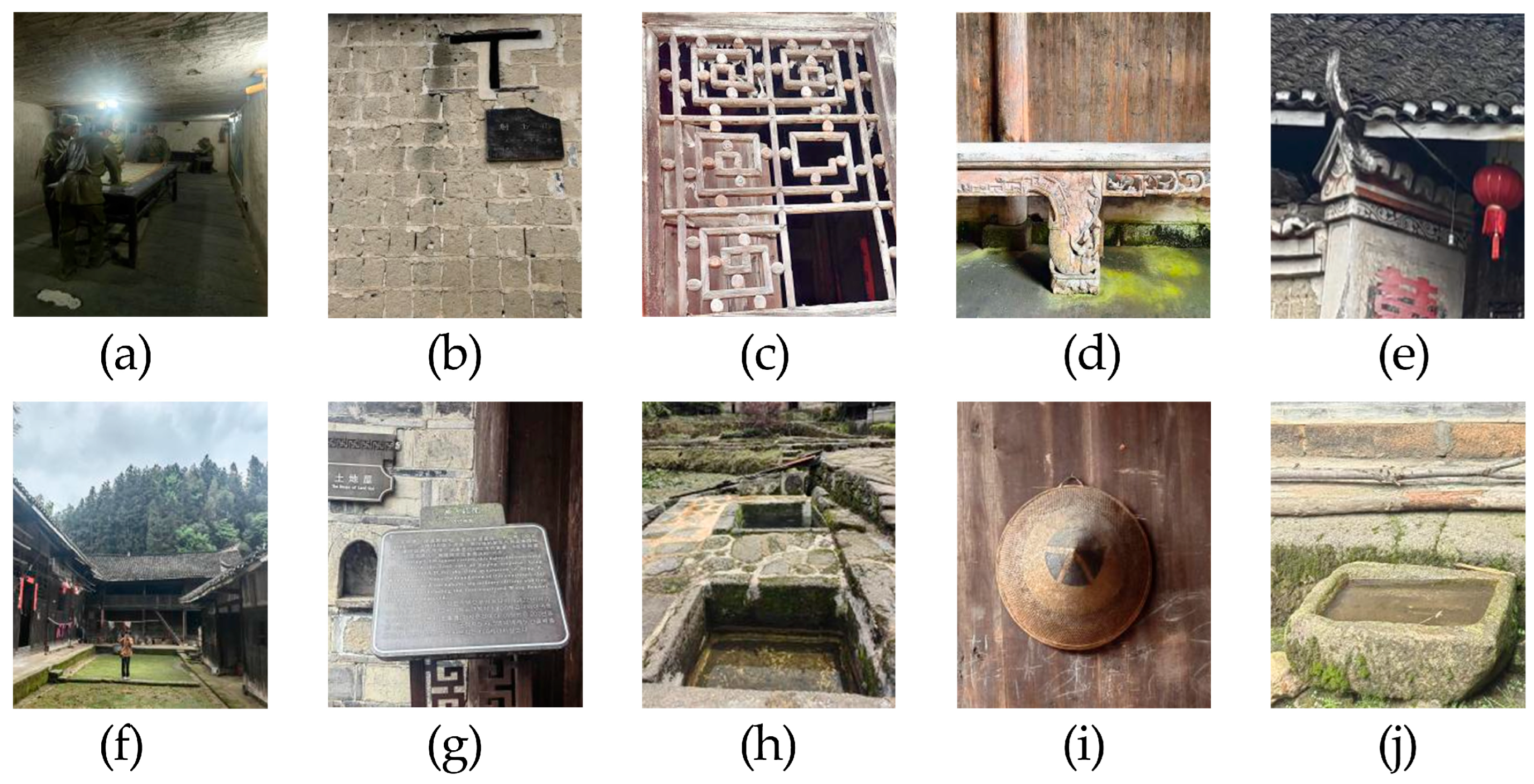
Among the 21 traditional villages in Xupu County, Yangquepo in Zhumucun Village, Hengbanqiao Township, was selected as a representative ancient village due to its typical and regionally significant characteristics. With a history spanning over 300 years, dating back to the Qianlong era of the Qing dynasty, Yangquepo consists of six courtyards designed in a typical Qing architectural style, covering more than 50,000 square meters. Despite the passage of time, the village’s architectural style remains remarkably well preserved. Features such as ancient walls, tiles, windows, wells, mural walls, and flying eaves continue to reflect the grandeur and refinement of the past (Figure 2a–j).

3.1.1. Typical Courtyard Atlas

The landscape culture of Yangquepo is categorized into material and immaterial cultural landscapes, with respective identification and extraction of landscape cultural genes (Table 2). The village showcases a rich variety of structural forms, including linear, “L”-shaped, and “U”-shaped layouts. By analyzing the characteristics of traditional residences in Yangquepo [23] and applying the “overall dominance” principle proposed by Xiang et al. [13], six courtyards were identified. These include the ancestral courtyard (2248 m2), the wartime courtyard (1500 m2), the ceremonial courtyard (1620 m2), the longevity and fortune courtyard (998 m2), the deaf east grand courtyard (1104 m2), and the last era grand courtyard (1104 m2). Each of these six independent quadrangles has unique features, offering a diverse range of architectural styles. The ancestral courtyard, which occupies the largest area among the traditional residences in Yangquepo, was selected as a representative example.

3.1.2. Spatial Sequence Atlas

Yangquepo is situated in a small, relatively secluded mountain basin, with elevations ranging between 560 and 580 m. The area resembles a natural Tai Chi diagram, characterized by abundant water sources, high humidity, and layers of surrounding trees. Paddy fields shimmer in the sunlight in front of the courtyards, enhancing the scenic beauty. The village’s geomorphology follows the Tai Chi pattern, with houses built along the mountain slopes. Most of the wing rooms are constructed as stilted buildings. A wartime underground command post is located 200 m south of the village entrance. The first four courtyards are built halfway up a small hillside, surrounded by landmarks such as Dawn Bridge, Tai Chi Well, and ancient bayberry trees. The deaf east grand courtyard is positioned on the eastern side, while the last era grand courtyard is located at the northernmost point.

3.2. Multiple Traditional Villages: Distribution Pattern Atlas of Landscape Cultural Genomes

Using drone aerial photography, 21 typical traditional villages in Xupu County, Huaihua, were classified according to the distribution patterns of their landscape cultural genomes. A spatial pattern atlas of these genomes was subsequently developed (Table 3). The distribution patterns primarily fall into five categories: (1) free arrangement (nine villages), tiered (four villages), strip or cluster distribution (four villages), grid pattern (two villages), and encircling the mountain (two villages). These patterns reveal the profound cultural depth of the Xushui region and the complex geographical features that significantly influence the spatial layout of these villages. Moreover, the quality of transportation infrastructure plays a crucial role in shaping the unique characteristics of the traditional villages in Xupu County.

3.3. Geographical Pattern Atlas of Xupu County, Huaihua

3.3.1. Overall Distribution

In the overall distribution, the 21 traditional villages of Xupu County, Huaihua, exhibit a “point–line–area” regional distribution pattern:
  • Point Distribution: These villages are primarily located in the western (Suoyixi Village, Renlichong Village), eastern (Lingxitang Village, Gaoping Village, Shangshang Village), and northern (Jinzihu Village, Baiwutou Village, Qinglongxi Village, Jinwuwai Village) parts of Xupu County. The villages are relatively isolated and do not form continuous linear or areal patterns.
  • Linear Distribution: Along the banks of the Xushui River, villages such as Maopo Village, Guangming Village, Niuxi Village, and Chuanyanshan Village are aligned linearly along the riverbanks or other geographical features like mountain ranges or roads. The Xushui River, as the main watercourse, profoundly influences the village layout. The flat and fertile riverbanks, with abundant water resources, facilitate village distribution along the river, supporting agriculture and daily life. This distribution mode is closely related to the direction of river flow, transportation routes, or natural barriers, reflecting human adaptation to and utilization of the natural environment.
  • Areal Distribution: In the southern part of Xupu County, including towns and villages like Gezhuping Town, Huangmaoyuan Town, Jiuxi River Township, Hengbanqiao Township, Longtan Town, Tongxi River Town, Beidouxi Town, and Xiaohenghou Township (including Jinniu Village, Gaoqiao Village, Jinzhong Village, Yanban Village, Yangquepo in Zhumucun Village, Wufeng Village, Shanbei Village), villages exhibit an areal distribution. This indicates that these villages are relatively concentrated, forming continuous distributions across larger geographical areas with convenient transportation and proximity. Such a pattern is influenced by factors like flat terrain, abundant resources, or historical population migrations.

3.3.2. Spatial Clustering

As shown in Figure 3, kernel density analysis in ArcGIS software reveals significant spatial clustering among the traditional villages in the study area, primarily centered around two areas: the cluster around Huangmaoyuan Town and the cluster around Jiuxi River Township. There is considerable variability in spatial clustering distribution, with most villages concentrated in the water-rich Xushui River basin. However, there is a distinct trend of clustering towards the south.
In the southern traditional villages, numerous ethnic groups, including the Han, Tujia, Yao, Miao, and Dong, live together. The exchange and integration of various ethnic cultures enhance the vibrancy and diversity of these villages’ folk cultures. Each village hosts ethnic-specific festivals and customary events for weddings and funerals, which not only display the traditional cultures of each ethnic group but also foster unity and friendship among them. Due to historical population movements, wars, and natural disasters, traditional villages in the eastern and western regions may have developed during different periods, often without unified planning and layout.
Villages on both sides of the Xushui River utilize the advantages of proximity to mountains and water, balancing defense and residential needs. Although modern transportation has developed, this distribution pattern remains preserved. Economically, agriculture remains the backbone of these villages, with riverside layouts enhancing production efficiency and promoting development. The Feng Shui principle of “backing mountains and facing water” strongly influences village site selection, forming a linear arrangement. Additionally, the residents’ psychological identification with and attachment to the land further reinforces the persistence of this distribution pattern.

4. Discussion

4.1. Characterization of Traditional Village Landscape Cultural Genome Atlases

4.1.1. Genetic Linkage Atlas

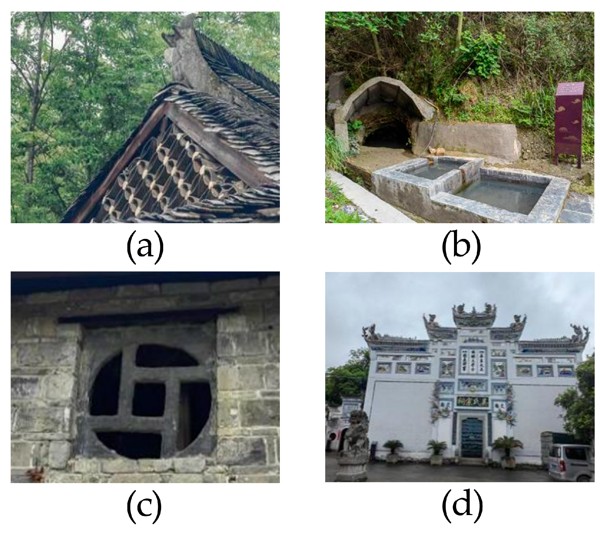
An analysis of the architectural styles, building materials, and decorative arts in traditional villages revealed significant continuity in cultural heritage both within and among the villages. Despite some minor variations, the villages generally share common cultural genes—such as hanging mountain roof tiles, decorated walls (Figure 4a), ancestral halls (Figure 4b), ancient wells (Figure 4c), and wood and stone carvings (Figure 4d). These elements reflect the deep cultural heritage and continuity that define the traditional villages of Xupu.

4.1.2. Spatial Sequence Atlas

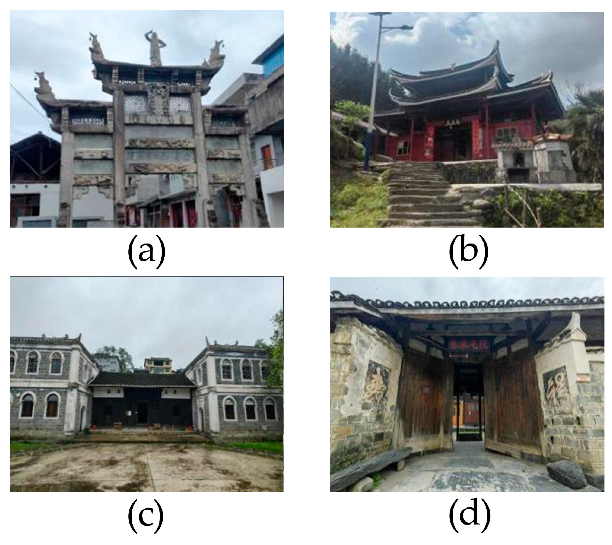
The spatial layout of traditional villages typically follows specific sequences and principles. Public buildings such as archways (Figure 5a), temples (Figure 5b), academies (Figure 5c), and clan halls (Figure 5d) often serve as central points around which residential houses are arranged. This spatial organization reflects the influence of ancient Feng Shui principles and illustrates the complex relationship between social structure and familial ties. The spatial sequence atlas effectively demonstrates the layered and orderly spatial organization within the villages. Understanding this spatial arrangement is crucial for developing effective conservation policies. Policies should prioritize the protection of public buildings that embody the historical and cultural significance of the village layout. This includes ensuring that any restoration efforts respect the original architectural styles and spatial relationships, thereby maintaining the cultural integrity of the village. Moreover, by recognizing the value of such spatial organizations, planners can foster community engagement and enhance local identity, ensuring that modernization does not compromise cultural heritage. A comprehensive approach to preserving the spatial organization of traditional villages will not only safeguard valuable cultural heritage but also contribute to the sustainable development of the area, creating a harmonious balance between past and present.

4.1.3. Distribution Pattern Atlas

The distribution of traditional villages in Xupu County is shaped by a combination of natural environmental factors, transportation conditions, and historical context. The findings show that these villages are primarily arranged along the natural topography of rivers and valleys, forming spatial patterns such as free arrangement, tiered, and encircling the mountain [9,24,25]. These patterns not only highlight the natural constraints on village site selection but also reveal the symbiotic relationship between human activities and the natural environment. Preserving the integrity of the natural topography can enhance ecological balance and maintain biodiversity within these traditional villages. Additionally, recognizing the historical context of village placement can inform policies that promote heritage conservation, ensuring that the cultural significance of these sites is honored.

4.1.4. Geographical Pattern Atlas

The analysis of the geographical patterns of traditional villages in Xupu County reveals a “point–line–area” geographical structure. Villages function as nodes interconnected by rivers and roads, forming a network that spans the entire county. This geographical pattern underscores the close connections and interdependence among villages and provides strong support for the comprehensive protection and preservation of regional culture.

4.2. Protecting and Sustaining Cultural Heritage in Traditional Villages: Strategies for Inheritance, Development, and Regional Integration

4.2.1. Inheritance and Protection of Cultural Genes

The primary goal of constructing traditional village landscape cultural genome atlases is to protect and preserve these valuable cultural heritages. By building and analyzing these atlases, we can gain a clearer understanding of the uniqueness and significance of traditional village cultures, which in turn facilitates the development of more scientific and effective conservation strategies. For culturally significant architectural and decorative elements, in situ protection and reinforcement can be employed. For cultural elements that have disappeared or are at risk of disappearing, methods such as documentation and replication can be used for urgent protection. Furthermore, constructing these atlases requires an interdisciplinary approach, integrating knowledge and methodologies from fields such as history, geography, architecture, and cultural studies [26]. A key future challenge lies in effectively conducting interdisciplinary research and integrating diverse disciplinary methods and findings.

4.2.2. Sustainable Development of Traditional Villages

Traditional villages are vital carriers of local culture and economic development, and their sustainable development is essential for the well-being of local residents, cultural transmission, and ecological balance in the region. Therefore, alongside protecting and preserving traditional village culture, their sustainable development must be prioritized [27,28]. As time progresses, the cultural landscape of traditional villages continues to evolve. A significant research challenge is to fully consider the various factors driving cultural change, ensuring that findings accurately reflect both the current characteristics of the cultural landscape and its historical context and inheritance pathways [29].

4.2.3. Comprehensive Protection and Inheritance of Regional Culture

The traditional villages of Xupu County are an integral part of the traditional village culture in the Yuan River Basin of Hunan Province. Protecting and preserving these villages requires attention to the unique circumstances of individual villages, while also adopting a broader regional perspective. By constructing regional traditional village landscape cultural genome atlases, we can achieve a more comprehensive understanding of the cultural characteristics and developmental trajectories of the entire region. This approach provides strong support for the comprehensive protection and inheritance of regional culture.

4.3. Outlook

The focus on 21 villages in Xupu County presents a limited sample size, potentially constraining the ability to fully capture the landscape cultural characteristics of the entire Yuan River Basin in Hunan. Future research should expand to encompass larger regional areas. Furthermore, while Yangquepo in Zhumucun Village serves as a representative case, its capacity to fully embody the typical characteristics of the traditional village landscape cultural genome requires further validation [30,31]. Incomplete historical records and documentary materials, such as those impacted by the fire on 16 January 2021 in Wufeng Village, Longtan Town, which resulted in the permanent loss of 14 farmhouses, highlight the need for more comprehensive surveys and the establishment of detailed archives and databases to ensure the preservation of these cultural heritages [32]. Second, while this study employs advanced tools such as point cloud, GIS, and ArcGIS for spatial analysis, the integration of additional technologies—such as 3D modeling, artificial intelligence, and machine learning—could enhance the visualization and interpretation of the dynamic evolution of traditional village landscapes [33,34,35]. These technologies may also offer deeper insights into the relationships between spatial patterns and cultural heritage elements.
Additionally, the atlases focus primarily on the spatial and cultural organization of the villages, without fully addressing the socioeconomic and political factors influencing landscape changes over time [36]. Future research should examine the impacts of local governance, economic development, and cultural policy on these landscapes, offering a more holistic understanding of the forces driving cultural evolution and preservation efforts. Finally, the atlases present a static representation of the landscape cultural genome. Future studies should prioritize longitudinal approaches that monitor the ongoing transformation of these landscapes, employing real-time data collection and analysis to capture dynamic changes. This would allow for a more comprehensive understanding of the temporal aspects of cultural heritage preservation.

5. Conclusions

This study extends previous research on settlement landscape genome atlases by constructing four distinct types of landscape cultural genome atlases for 21 traditional villages in Xupu County, Huaihua. Through detailed illustrations and in-depth analyses, the research reveals the rich cultural heritage and unique regional characteristics of these traditional village landscapes, providing a scientific foundation for their protection, inheritance, and sustainable development. The key findings include the development of genetic linkage, spatial sequence, distribution pattern, and geographical pattern atlases and addressing traditional village landscapes at three levels: individual villages, multiple villages, and specific research areas. Using Yangquepo in Zhumucun Village as a case study, a genetic linkage atlas was constructed based on courtyard structures, complemented by spatial sequence and distribution pattern atlases derived from kernel density analysis in ArcGIS. These atlases highlighted various distribution patterns, including free arrangement, tiered, strip or cluster distribution, grid, and encircling the mountain, further illustrating the “point-line-area” regional distribution characteristic of the villages.

Author Contributions

Conceptualization, L.W. and M.W.; methodology, L.W. and X.X.; software, L.W. and C.S.; validation, L.W. and X.X.; formal analysis, L.W. and X.X.; investigation, C.S. and X.X.; resources, L.W. and M.W.; data curation, L.W.; writing—original draft preparation, L.W. and C.S.; writing—review and editing, M.W.; visualization, C.S.; supervision, M.W. and X.X.; project administration, M.W.; funding acquisition, L.W. All authors have read and agreed to the published version of the manuscript.

Funding

This research was supported by the Hunan Provincial Natural Science Foundation of China (grant number: 2024JJ5295) and the General Project of Philosophy and Social Sciences in Hunan Province (grant number: 22YBA306).

Informed Consent Statement

Not applicable.

Data Availability Statement

This study did not report any publicly archived datasets.

Conflicts of Interest

The authors declare no conflicts of interest.

References

  1. Wang, W.; Li, W.; Pan, J.; Deng, X.; Xiao, H. Research Progress and Prospect of Landscape Gene Theory in China. J. Yunnan Agric. Univ. (Soc. Sci.) 2023, 17, 122–130. [Google Scholar] [CrossRef]
  2. Taylor, G. Environment, Village and City: A Genetic Approach to Urban Geography; with Some Reference to Possibilism. Ann. Assoc. Am. Geogr. 1942, 32, 1–67. [Google Scholar] [CrossRef]
  3. Conzen, M.R.G. Morphogenesis, morphological regions and secular human agency in the historic town-scape, as exemplified by Ludlow. In Urban Historical Geography. Recent Progress in Britain and Germany; Cambridge University Press: Cambridge, UK, 1988. [Google Scholar]
  4. Matlovičová, K. The Triadic Nexus: Understanding the Interplay and Semantic Boundaries Between Place Identity, Place Image, and Place Reputation. Folia Geogr. 2024, 66, 69–102. [Google Scholar]
  5. Matlovicova, K.; Husarova, M. Potential of the Heritage Marketing in Tourist Destinations Development. Cicva Castle Ruins Case Study. Folia Geogr. 2017, 59, 5–35. [Google Scholar]
  6. Hu, Z. A Research on the Geographical Information Features of Traditional Settlement Landscape Gene and the Related Understanding Approaches. J. Geo-Inf. Sci. 2020, 22, 1083–1094. [Google Scholar] [CrossRef]
  7. Shuai-qian, C. Imagery Pattern of Intangible Cultural Heritage Landscape Gene Mining—In Hunan Province. Econ. Geogr. 2014. [Google Scholar]
  8. Jordan, P. Role of Place Names in Relating People and Space. In Handbook of the Changing World Language Map; Brunn, S.D., Kehrein, R., Eds.; Springer International Publishing: Cham, Switzerland, 2018; pp. 1–16. [Google Scholar]
  9. Sauer, C.O. The Morphology of Landscape; University of California Publications: Oakland, CA, USA, 1925. [Google Scholar]
  10. Whittlesey, D. Sequent Occupance. Ann. Assoc. Am. Geogr. 1929, 19, 162–165. [Google Scholar] [CrossRef]
  11. Walmsley, D.J.; Lewis, G.J. People and Environment: Behavioural Approaches in Human Geography, 2nd ed.; Longman Scientific: Harlow, UK, 1993; 290p. [Google Scholar]
  12. Zu, H. A Novel Method for Identifying and Separating Landscape Genes from Traditional Settlements. Sci. Geogr. Sin. 2015, 35, 1518–1524. [Google Scholar]
  13. Xiang, Y.; Cao, M.; Qin, J.; Wu, C. Study of traditional rural settlements landscape genetic variability in Shaanxi Province based on accurate-restoration. Prog. Geogr. 2020, 39, 1544–1556. [Google Scholar] [CrossRef]
  14. Fang, Q.; Li, Z. Cultural ecology cognition and heritage value of huizhou traditional villages. Heliyon 2022, 8, e12627. [Google Scholar] [CrossRef]
  15. Ma, Y.; Zhang, Q.; Huang, L. Spatial distribution characteristics and influencing factors of traditional villages in Fujian Province, China. Humanit. Soc. Sci. Commun. 2023, 10, 883. [Google Scholar] [CrossRef]
  16. Caneva, G.; Traversetti, L.; Sujarwo, W.; Zuccarello, V. Sharing Ethnobotanical Knowledge in Traditional Villages: Evidence of Food and Nutraceutical “Core Groups” in Bali, Indonesia. Econ. Bot. 2017, 71, 303–313. [Google Scholar] [CrossRef]
  17. Zhu, H.; Xu, Y.; Situ, S. Recent advance of cultural geography in China. Chin. Geogr. Sci. 1999, 9, 306–313. [Google Scholar] [CrossRef]
  18. Zhai, Z.; Li, T.; Chang, F.; Luo, Y.; Shi, Y. Genes identification of cultural heritage landscape of Shaanxi Traditional Villages. Prog. Geogr. 2017, 36, 1067–1080. [Google Scholar] [CrossRef]
  19. Michel, J.-B.; Shen, Y.K.; Aiden, A.P.; Veres, A.; Gray, M.K.; Team, T.G.B.; Pickett, J.P.; Hoiberg, D.; Clancy, D.; Norvig, P.; et al. Quantitative Analysis of Culture Using Millions of Digitized Books. Science 2011, 331, 176–182. [Google Scholar] [CrossRef]
  20. Lachlan, R.F.; Feldman, M.W. Evolution of cultural communication systems: The coevolution of cultural signals and genes encoding learning preferences. J. Evol. Biol. 2003, 16, 1084–1095. [Google Scholar] [CrossRef]
  21. United Nations Group of Experts on Geographical Names. Resolutions from the Ninth United Nations Conference on the Standardization of Geographical Names; United Nations: New York, NY, USA, 2007. [Google Scholar]
  22. Aihua, X. Cultural Diversity of Traditional Settlement Landscape Gene. J. Landsc. Res. 2023, 15, 20–26. [Google Scholar]
  23. Li, G.; Chen, B.; Zhu, J.; Sun, L. Traditional Village research based on culture-landscape genes: A Case of Tujia traditional villages in Shizhu, Chongqing, China. J. Asian Archit. Build. Eng. 2024, 23, 325–343. [Google Scholar] [CrossRef]
  24. Verdini, G.; Frassoldati, F.; Nolf, C. Reframing China’s heritage conservation discourse. Learning by testing civic engagement tools in a historic rural village. Int. J. Herit. Stud. 2017, 23, 317–334. [Google Scholar] [CrossRef]
  25. Wimsatt, W.C. Genes, Memes, and Cultural Heredity. Biol. Philos. 1999, 14, 279–310. [Google Scholar] [CrossRef]
  26. Duncan, J. Landscape geography, 1993–1994. Prog. Hum. Geogr. 1995, 19, 414–422. [Google Scholar] [CrossRef]
  27. Oliveira, V. Teaching Urban Morphology. Urban Morphol. 2018, 23, 93–95. [Google Scholar]
  28. Oakes, T.; Price, P.L. (Eds.) The Cultural Geography Reader, 1st ed.; Routledge: London, UK, 2008. [Google Scholar] [CrossRef]
  29. Filomena, G.; Verstegen, J.A.; Manley, E. A computational approach to ‘The Image of the City’. Cities 2019, 89, 14–25. [Google Scholar] [CrossRef]
  30. Porta, J.; Parapar, J.; Doallo, R.; Barbosa, V.; Santé, I.; Crecente, R.; Díaz, C. A population-based iterated greedy algorithm for the delimitation and zoning of rural settlements. Comput. Environ. Urban Syst. 2013, 39, 12–26. [Google Scholar] [CrossRef]
  31. Deadman, P.J.; Brown, R.D.; Gimblett, H.R. Modelling Rural Residential Settlement Patterns with Cellular Automata. J. Environ. Manag. 1993, 37, 147–160. [Google Scholar] [CrossRef]
  32. Du, J.; Cheng, L.; Zhang, Q. Spatiotemporal variability and trends in the hydrology of the Xiang River basin, China: Extreme precipitation and streamflow. Arab. J. Geosci. 2019, 12, 566. [Google Scholar] [CrossRef]
  33. Yang, C.; Han, F.; Shutter, L.; Wu, H.B. Capturing spatial patterns of rural landscapes with point cloud. Geogr. Res. 2020, 58, 77–93. [Google Scholar] [CrossRef]
  34. Li, J.L.; Chu, J.L.; Wang, Y.Z.; Ma, M.; Yang, X.G. Reconstruction of Traditional Village Spatial Texture Based on Parametric Analysis. Wirel. Commun. Mob. Comput. 2022, 2022, 1–24. [Google Scholar] [CrossRef]
  35. Duan, Y.P.; Yan, L.Q.; Lai, Z.L.; Chen, Q.T.; Sun, Y.Y.; Zhang, L. The spatial form of traditional villages in Fuzhou area of Jiangxi Province determined via GIS methods. Front. Earth Sci. 2022. [Google Scholar] [CrossRef]
  36. Liu, L.L.; Chen, M.; Luo, P.P.; Hu, M.C.; Duan, W.L.; Elbeltagi, A. A Novel Integrated Spatiotemporal-Variable Model of Landscape Changes in Traditional Villages in the Jinshaan Gorge, Yellow River Basin. Land 2023, 12, 1666. [Google Scholar] [CrossRef]
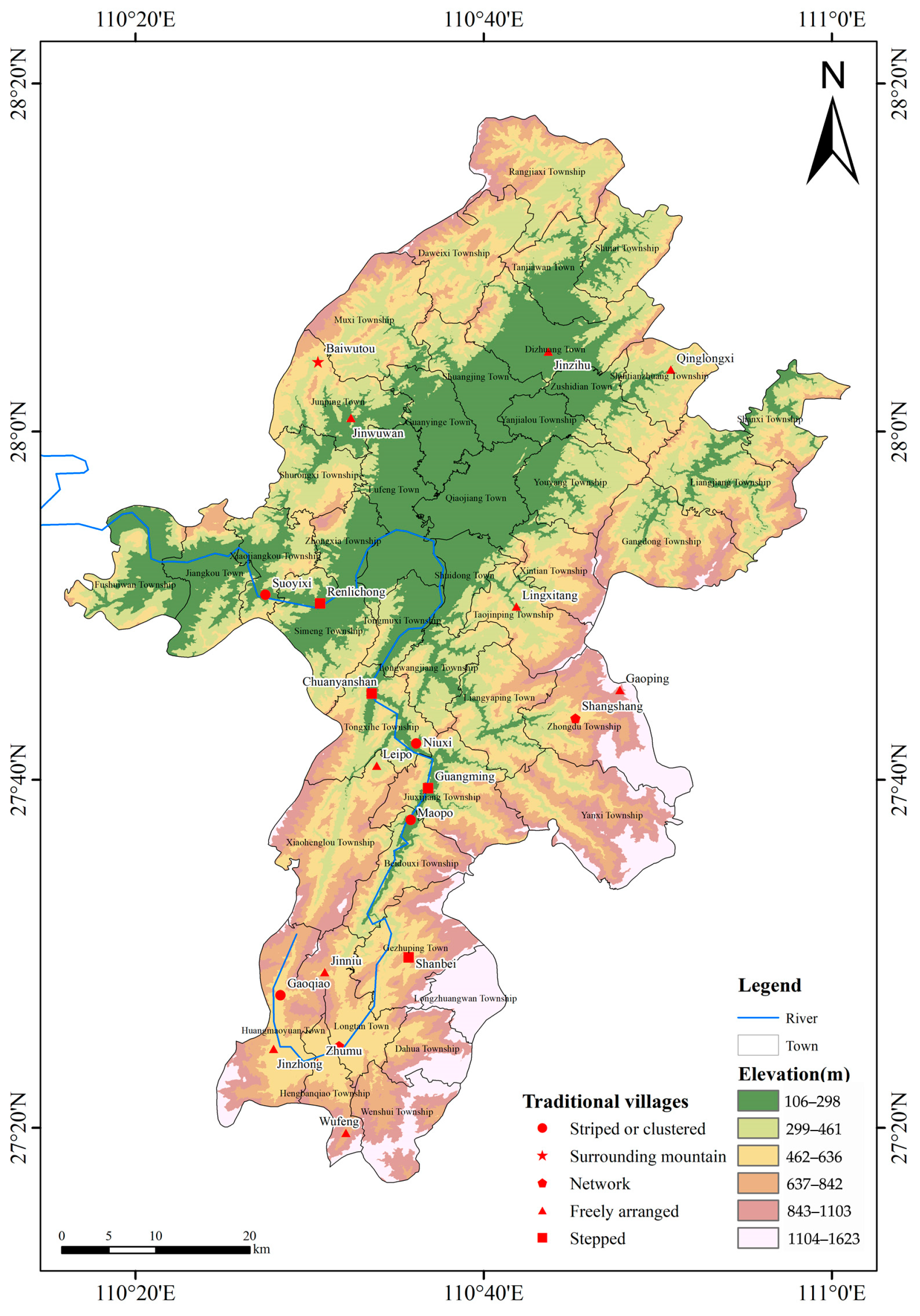
Figure 1. Study sample: 21 nationally recognized traditional villages within Xupu County.
Sustainability 16 09524 g001
Figure 2. (a) Underground command post; (b) shooting hole; (c) wooden window; (d) piano stool; (e) painted; (f) LongDong Courtyard; (g) land god house; (h) Tai Chi well; (i) bamboo hat; (j) sharpening pool.
Sustainability 16 09524 g002
Figure 3. Spatial aggregation kernel density analysis.
Sustainability 16 09524 g003
Figure 4. (a) Mountain flower wall in Baiwutou Village; (b) Ancient Well of Renlichong Village; (c) stone carving in Wufeng Village; (d) Wu Clan Ancestral Hall, Yanban Village.
Sustainability 16 09524 g004
Figure 5. (a) Jinzhong Village Centennial Place; (b) Chaoyangan in Sang Village; (c) Chongshi Seowon in Yanban Village; (d) Zhang Wenzheng’s official residence in Guangming Village.
Sustainability 16 09524 g005
Table 1. Traditional village landscape cultural genome mapping system.
TypesObject of the ExpressionContents of the Expression
Genetic linkage atlasIndividual traditional villageThe arrangement structure of the various elements or features constituting the traditional village landscape culture not only reflects the internal logic and hierarchical relationship of the village landscape culture, but also reveals how these elements are spatially interrelated and interact with each other.
Spatial sequence atlasIndividual traditional villageFocuses on visualizing the structure of the spatial layout of the cultural genome of individual traditional village landscapes by means of diagrams.
Distribution pattern atlasMultiple traditional villagesBy extracting and abstracting the laws of cultural spatial layout of multiple village landscapes, the common features and differences in the spatial distribution of these villages are shown graphically.
Geographical pattern atlasSpecific research areaThe spatial distribution pattern of the villages in the study area, the degree of agglomeration, and their interaction with the surrounding environment are visually demonstrated by means of diagrams.
Table 2. Identification and extraction of cultural genes in the landscape of Yangquipo.
Classification FactorTitle 4
Material cultural landscapesLandscape featuresCharacteristics of the external landscape of traditional villagesSites and patternsSmall mountain basin
Village patternTai Chi pattern
Characteristics of the internal landscape of traditional villagesDistribution patternsSix quadrangles are staggered across a slope of more than 200 m in length and breadth.
Street patternPaved with stone slabs and meandering
Structural formsLinear, “L”-shaped, and “U”-shaped layouts
Architectural patternCourtyard house structure (type of Chinese residence)
Roof patternHanging mountain roof
Architectural featuresCharacteristics of traditional residencesMountain wall patternHorse-head wall, triangular
Floor patternOne or two floors
Architecture materialWood, brick, tile, stone
Topical decorationsWood carving and color painting
immaterial cultural landscapes Clan characteristicsClan characteristicsWang’s, Mezzanine Hall
Characteristics of beliefsTarget of beliefLand god
Characteristics of the customCustoms as regards recreation and sportPatty cake making, tofu grinding, New Year’s pig killing, crying marriage, welcoming the bride, throwing embroidery balls, spinning yarn, picking flowers, embroidering dragon lanterns, lion lanterns, mussel-shell lanterns, yelling lanterns, boat lanterns, story lanterns, goose-neck lanterns, grass-dragon lanterns, bamboo dragon lanterns, colorful boats and paper-cutting.
Dialect characteristicsLocal dialectGan dialect, spoken in Jiangxi Province
Table 3. Distribution pattern mapping.
Distribution PatternsTypical Traditional VillagesCharacterization of the VillageSchematic Diagram
Free arrangementGaoping Village; Jinniu Village; Jinwuwai Village; Jinzhong Village; Leipo village; Lingxitang Village; Wufeng Village; Qinglongxi Village; Jinzihu Village The buildings are dispersed in the space of the mountain settlement, forming a free discrete pattern.Sustainability 16 09524 i001
TieredShanbei Village; Guangming Village; Renlichong Village; Chuanyanshan Village Village buildings are located along contours or ridgelines.Sustainability 16 09524 i002
Strip or cluster distributionGaoqiao Village; Niuxi Village; Suoyixi Village; Maopo VillageDistributed along ridges, slopes or river valleys.Sustainability 16 09524 i003
Encircling the mountainBaiwutou Village; Yangquepo in Zhumucun VillageBased on the natural terrain such as Turtle Mountain and Saigon Shrine, it is distributed along the ravines, slopes, and other natural terrain.Sustainability 16 09524 i004
Grid patternShangshang Village; Yanban VillageThe villages are built on hills and form settlements around water sources.Sustainability 16 09524 i005
Disclaimer/Publisher’s Note: The statements, opinions and data contained in all publications are solely those of the individual author(s) and contributor(s) and not of MDPI and/or the editor(s). MDPI and/or the editor(s) disclaim responsibility for any injury to people or property resulting from any ideas, methods, instructions or products referred to in the content.