1. Introduction
The Xishu region, centered around the Chengdu Plain, extends across several counties and cities from north to south, including Mianyang, Deyang, Guanghan, Shifang, Pengzhou, Dujiangyan, Pixian, Chengdu, Shuangliu, Dayi, Xinjin, Ya’an, Emei Mountain, and Leshan. The Xishu Garden complex traces its origins back to the ancient Shu period and is a cherished local feature profoundly influenced by the distinct natural and cultural environment of the region [
1]. Like other types of gardens in China, Xishu Gardens has experienced periods of prosperity and decline; yet, today, it retains architectural styles from numerous historical periods. The more well-preserved garden buildings are those left standing or restored from the Ming and Qing Dynasties and the Republic of China era, such as the Mengshan Sisun Temple, Wuhou Temple, Wangjiang Lou, and Chengdu Du Fu’s Thatched Cottage [
2,
3]. Xishu Gardens are a part of the classical Chinese gardens. They are characterized by their unique ancient Shu historical culture, distinctive natural geography, and a sense of simulating nature that distinguishes their traditional garden design approach [
4,
5]. Blessed with fertile soil and a flourishing agricultural sector, Xishu embodies a philosophy of simplicity and harmony with nature, which is mirrored in the layout and aesthetics of its landscapes [
6]. Xishu Gardens are deeply influenced by Daoist philosophy, emphasizing the concepts of “unity of heaven and humanity” and “the Dao follows nature”. The designers of Xishu Gardens aim for a harmonious coexistence with nature rather than seeking to conquer or transform it.
The gardens were meticulously designed to blend seamlessly with the environment, incorporating elements of natural rock formations and local vegetation to create a visually stunning and serene, natural space. The respect for nature and the degree of harmonious coexistence are markedly higher compared to other gardens. The garden design philosophy of Xi Shu serves as a spatial template influencing humanity’s transformation of the external environment. Lan Xianlin, in his work “A Grand View of Chinese Classical Gardens”, considers Xishu Gardens as the primary essence of Southwest gardens and highlights their natural wilderness, seclusion, and captivating beauty. This perspective showcases a systematic approach to research and inquiry, presenting a renewed framework [
7,
8,
9]. The term “space”, as applied in this context, was coined by August Schmarsow (1853–1936) in his 1893 lecture, “The Essence of Architectural Creation”. Different scholars have varying interpretations of the definition of space. Tschumi points out that space does not exist unless human activity gives it meaning. Roger Scruton believes that space does not exist. However, Hillier B. argues that, in architectural design and urban planning, the research object should be the real space itself. The core of research on spatial issues lies in the interrelationships between spaces. Space syntax theory aims to clarify these complex spatial relationships, rather than to obscure them [
10,
11,
12,
13]. Since the mid-19th century, quantitative analysis methods have been born in the West and have gradually become a paradigm of research methods. This approach is based on the foundation that computers can perform a large number of calculations and analyses, digitize various elements, and then analyze them to derive more objective, rational, and rigorous results. Against this backdrop of development, space syntax has emerged. The core philosophy of space syntax involves utilizing a novel language and technological approaches to analyze spaces and configurations that elude precise description by humans. Bill Hillier’s “Space is the Machine” established the research foundation for space syntax [
14,
15,
16]. Space syntax, a theory and methodology for understanding the relationship between urban environments and human behavior, was pioneered by Bill Hillier and his colleagues in the late 1970s and early 1980s [
17,
18,
19].
In terms of spatial syntax analysis technology, Li Zhijie et al. proposed a readily applicable quantification method for horizon analysis that effectively captures the visual characteristics of space. Xiao Yang et al. explored the enhancement and expansion of spatial syntax theory in urban planning based on geospatial analysis, emphasizing the need for informed judgment at specific sites to fully leverage its potential effectiveness. Li Changhua et al. introduced an axis extraction method based on axis constraint definition, significantly improving the accuracy of spatial syntax models. Today, DepthmapX0.8.0 is commonly employed for syntax analyses involving line-of-sight and relationships between line segment axes diagrams and overall structures, encompassing crucial factors such as positional relationships, angles, measured distances, and topological distances within a space [
9,
20,
21,
22].
Analyses of existing scholarly work on classical Chinese gardens reveal two predominant approaches: qualitative and quantitative. Qualitative analysis, often characterized by a dearth of comprehensive study objectives, is largely interpretive and subjective from the researcher’s viewpoint. In contrast, quantitative analysis is grounded in the rigorous gathering of data and the application of logical reasoning to the subject under scrutiny [
23,
24,
25,
26].
The spatial analysis of classical Chinese gardens has typically been conducted through qualitative means, which frequently fall short in terms of objective data analysis. In the context of traditional garden design inheritance, an exclusive focus on integrating expressive elements and materials with contemporary aesthetics, while neglecting spatial configuration, fails to adequately address the fundamental issues related to regional cultural expression [
27,
28]. Space syntax emphasizes the analysis of space itself, thereby minimizing the impact of factors such as the materials, colors, and textures of surrounding elements. The fundamental goal of it is to explore and articulate the intricate relationships and features within a spatial system. It achieves this goal by dissecting space and employing mathematical techniques to analyze the geometric representations of various spatial elements, which could range from rooms and lines to convex spaces, visual fields, and even individual points. This methodology offers a nuanced comprehension of spatial configurations [
29].
Additionally, the notion put forth by Bill Hillier—that a holistic spatial experience is more effectively realized through movement—echoes the insights of Mr. Yang Hongxun in “Jiangnan Garden Theory”. Yang Hongxun posits that the interplay of pathways and vistas gives rise to a dynamic sequence of scenes, highlighting the garden’s spatiotemporal artistry. This resonance underscores an intrinsic similarity between the spatial logic of space syntax and the traditional Chinese garden’s spatial design philosophy [
27]. Extracting regular spatial structural characteristics from abstract intentions can enhance the scientific analysis of the inheritance of Xishu Garden construction techniques in Qingxi Garden.
The deployment of space syntax as a quantitative method is gaining traction in the exploration of garden spaces. Jin Ding, in his study, chose the Liuyuan, Wangshiyuan, and Guozhuang gardens, employing Depthmap for a lucid analysis of their spatial configurations and introduced the concept of “vague configuration” within classical gardens. Chen Rong embarked on a comparative spatial configuration analysis of the Yu Garden and the Suzhou Museum, leveraging their contrasting features as a starting point. Chen Ming applied Depthmap software to evaluate China’s Humble Administrator’s Garden and the Flowing Fragrance Garden in the United States, the practicality of using space syntax in the study of classical Chinese gardens confirmed. Huishu Chen integrated the principles of space syntax with narratology, performing a spatial quantification analysis of the Humble Administrator’s Garden. Jiayan Yun employed space syntax to dissect the role of water systems in the developmental history of Suzhou gardens [
30,
31,
32,
33,
34,
35]. Nonetheless, there exists a noticeable absence of research applying space syntax methodologies to the garden spaces of Xishu. Previous research on spatial syntax in traditional Chinese gardens primarily focused on private gardens located south of the Yangtze River. Commonly referenced examples include the Humble Administrator’s Garden, the Master’s Garden, and the Garden, all royal garden landscapes situated in the north [
18]. However, due to complex road alterations and limited research experience regarding Western Shu gardens, particularly in the Xishu geographic area, they have been less frequently researched. In this study, quantitative evaluations using DepthmapX 0.8.0 software simulation data, alongside offline data collected from Qingxi Garden within Dujiangyan Scenic Area, were analyzed to obtain a series of novel theoretical findings.
2. Materials and Methods
2.1. Introduction to Qingxi Garden
The Lidui Park area within Qingxi Garden is situated within the Dujiangyan Scenic Area, a national 5A tourist attraction. Dujiangyan is a large-scale water conservancy project constructed in ancient China and still in use today, located to the west of Dujiangyan City, Sichuan Province, 340 km upstream of the Min River. The project mainly serves for water diversion and irrigation, and it also has comprehensive functions such as flood control, sediment discharge, water transport, and urban water supply. Qingxi Garden, located within the Lidu Park of the Dujiangyan scenic area, is a garden within the Dujiangyan scenic area, and, in 2000, it was listed on the World Heritage List along with Dujiangyan (
Figure 1). Covering an area of more than 8000 m
2, it is the largest bonsai garden in Xishu.
The architectural blueprint of Qingxi Garden draws inspiration from traditional Xishu folk houses, showcasing an understated elegance infused with simplicity and vitality [
36]. In terms of landscaping, water features take precedence, with locally sourced materials for waterscape stones serving as the focal point. Carefully selected pebbles of varying sizes, sourced from the Minjiang River, were carefully placed to not only enhance visual appeal but also to highlight the distinctive characteristics of Dujiangyan’s water culture [
37]. Qingxi Garden integrates the traditions of Chinese classical garden design, bonsai exhibitions, and the unique water culture of the ancient Dujiangyan irrigation system, creating a bonsai art display space that, despite being man-made, resembles a natural wonder. It is acclaimed by the public as the “Number One Garden in Southwest China”.
2.2. Research Methodology
A variety of methodologies were employed in this study, including historical data analysis, field surveys, questionnaires, and simulations to formulate a comprehensive plan for Qingxi Garden. Utilizing space syntax’s convex space analysis, axial model analysis, and scene line-of-sight analysis, in conjunction with DepthmapX 0.8.0 for the analysis, were also employed. DepthmapX 0.8.0 is an open-source and multi-platform spatial analysis software for spatial networks of different scales. DepthmapX 0.8.0 is a versatile tool that functions across different scales, from individual buildings and small urban locales to extensive cities or entire states. Its mission at every scale is to create a detailed map of spatial components and establish connections between them through various relationships. Subsequently, it carries out a comprehensive graph analysis on the network that these connections form. The ultimate aim of this analysis is to identify variables that could potentially be significant in social or experiential contexts. Convex spaces are the most basic spatial units that make up the spatial system, where any two positions within the space can be directly connected by a person’s line of sight. In model drawing, it is necessary to follow the principle of being the fewest and largest, dividing the entire space under study in a simple and clear manner. The divided convex spaces become spatial nodes. The connections between each spatial node are represented by straight lines.
We gathered data on garden road spaces and analyzed parameters like road connectivity, spatial depth, and spatial integration degree through multidimensional simulation operations.
When analyzing line axes, roads were represented by simple road axes derived from the target plot’s road network. Connecting these axes generated an intersection diagram of line segments. We first created a floor plan of the park using surveying and mapping data in AutoCAD2023 software. The main entrance of Qingxi Garden is oriented northeast. The overall layout of the garden follows the natural topography and the common practice of constructing buildings along the road. Then, new layers were established to draw the line segments with their axes intersecting at the center of each road segment. When drafting a site plan in AutoCAD, dedicated layers were created for road segments, making certain that all park roads were connected without any blockages. Space syntax cannot utilize semi-transparent divisions to separate the visual spatial relationships affected by windows and similar elements. In relatively open and windowed spaces, walls, or other types of markers were removed to prevent the model from miscalculating their presence, thereby reducing calculation errors caused by recognition inaccuracies. Only the axis diagram was exported for analysis in DepthmapX 0.8.0, omitting the original plan.
Both previously drawn roads and scene plans within the park were utilized for a scene line-of-sight model analysis. Paths were ensured to be unobstructed, enabling seamless connectivity between all roads within the park. When analyzing indoor facilities, partitions were avoided and entrances/exits for buildings were accurately defined. Entrances/exits to the park were simulated in the form of a closed graph to further ensure accurate results in DepthmapX 0.8.
The following specific indicators were considered in this analysis:
Depth, which refers to the length of the line segment formed by two points in space, is a measure of the distance between highlight points. A higher depth value indicates lower accessibility.
Visible depth is the amount of observable content in space to other spaces; higher visible depth indicates lower reachability.
Connectivity, which denotes the number of connections between nodes in the space, reflects the correlation among spatial nodes. A higher connectivity value implies a stronger correlation.
Visual range isotope (Isovist area), quantifying the amount of content that can be observed by individuals within a certain node, signifies the openness and visibility of nodes.
Visual integration represents the overall relationship that constitutes space in the gardens; higher visual integration signifies stronger accessibility.
In the above formulas, n is the total number of elements in the system, and a1 represents the calculated value of element a1 in System A.
3. Spatial Syntax Analysis of Qingxi Garden
3.1. Topological Relationship of Landscape Points
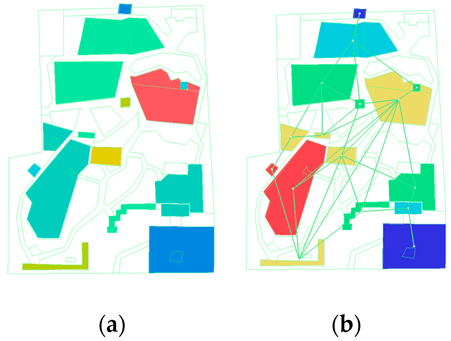
A plan was drawn (
Figure 2) based on field surveys and measurements, dividing the scenic area into blocks with road markings to create a simplified landscape node map. Simulations were conducted according to the convex space rules in DepthmapX 0.8.0. The convex space of the division was taken as a unit, then a relationship diagram was obtained between nodes in the space through simulation operations (
Figure 2). In Xishu Gardens, the prevalence of irregular natural pathways often diminishes the effectiveness of space syntax applications. To address this issue, optimizing the design of certain paths can help represent the overall architecture, roadways, and spatial relationships within the gardens more consistently. This regularization facilitates a more comprehensive quantitative analysis and evaluation of the spatial structure in Xishu Gardens, thereby enhancing both the accuracy and utility of the studies.
In the creation of the model, we applied principles of minimal and maximal spatial division to classify the landscape nodes within Qingxi Garden. We identified 16 landscape spatial nodes, categorizing them as convex spaces for analytical purposes. The concept of “average depth” refers to the average number of spaces or steps required to traverse the shortest path between two nodes. The depth value is a crucial parameter in the garden system simulation, reflecting the extent of spatial dispersion relative to other spaces within the system. A higher depth value indicates a more central position within the system, whereas a lower depth value suggests relatively less centrality [
38]. In the context of the Xishu Garden system, the depth value delineates the relationship between entrance and exit points (front and back doors) and landscape features throughout the scenic area. By setting this parameter to 0.00 and obtaining reference data, we conducted a comparative analysis between the data obtained from simulations and the actual distribution of convex spaces. We identified specific spaces, such as ponds, within the gardens through tabulated information. Consequently, we inferred that areas with greater depth (such as those in the eastern direction of the park) have poorer accessibility (
Table 1).
Similarly, when examining connectivity parameters during the simulation analysis, landscape nodes with higher depth values were found to exhibit lower connectivity levels [
39]. Connectivity refers to the number of connections between spatial nodes, highlighting the extent of their correlation. Higher connection values imply a reduced need for traversal from one space to another through auxiliary spaces, thereby enhancing spatial permeability and accessibility [
40]. Conversely, lower connectivity values indicate limited reachability based on the corresponding depths.
Notably, discrepancies arose between the observed depth values and connectivity values among spatial nodes in the simulations we conducted. These discrepancies likely originate from the specific simulation conditions we used, necessitating the introduction of the actual on-site conditions for further analysis. While the space syntax operations may not fully accurately reflect the actual on-site conditions, an overall spatial simulation can enable preliminary conclusions.
We find that spaces with higher connection values and lower depth values tend to have greater accessibility, attract more visitors, and better facilitate the aggregation of visitors flowing through the space. Specifically, these spaces include the front garden gate, inner courtyard, garden wall corridor, crepe vine vase area, large bonsai area, nanmu forest, and back garden gate.
3.2. Road Analysis
Another plan was drawn according to field surveys and measurements (
Figure 3). Then, the road network was simplified into line segments for further simulation operations in DepthmapX 0.8.0 software.
The relationship between the garden’s path system and its spatial structure has a significant impact on the overall garden space experience [
41]. In theoretical spatial syntax analysis, a sequence of spaces suggests how a space should be utilized rather than merely describing the space itself [
42]. In
Figure 4 above, the color change from blue to red indicates varying degrees of spatial depth. A deeper blue corresponds to a lower spatial depth, whereas a deeper red is associated with a higher spatial depth. The road connectivity between the entry and exit doors of the scenic area is relatively high, as is the connectivity in the central part of the park. The functional roles of front and back entrances make them primary conduits linking most of the key points in the scenic area. Consequently, the majority of attractions are clustered between these two points, facilitating pedestrian flow. These gateways connecting the interior and exterior of the park bear the brunt of the space’s foot traffic and road connectivity functions, hence their heightened connectivity.
Regarding the road integration degree, areas of greater concentration are considered to be more vibrant. The sections of the landscape highlighted red in
Figure 4, particularly the crepe myrtle vase and bonsai area, are crucial focal points within the gardens. These strategically positioned areas, located in the most accessible zones, showcase ornamental landscapes and materials of profound significance in terms of the cultural and aesthetic value of the gardens [
43]. Their prominence serves as evidence of the park’s scientifically executed design and scene planning.
In our graphic analysis of road depth values, we found that areas with higher depths include the stream on the left side of the main entrance, the southern road adjacent to the pond, and the vicinity of Qingxin Pavilion. This observation is consistent with our previous findings, which indicated that areas with higher depth and lower connectivity values tend to be less central and more secluded within the landscape. These areas are less likely to serve as focal points and are typically harder to access. Qingxi Pavilion, while situated in a visually appealing location adjacent to the central pond, presents challenges in accessibility due to the pond’s secluded characteristics and the complexity of the surrounding road network. Visitors must find their own way to the pavilion, and its status as a secondary site for bonsai exhibitions further reduces its attractiveness to potential visitors. This situation is consistent with both the real-world conditions and the results of our simulations.
Space syntax integration assesses the potential of a space to attract traffic; a higher level of integration signifies improved accessibility and centrality, thereby increasing its ability to draw visitors. An analysis of road integration, coupled with field investigations, revealed that scenic attractions on the right side are more abundant than those on the left side, with greater visual spatial permeability. These surveys substantiate the rationality of incorporating such design and layout processes for key spaces within the scenic area.
3.3. Spatial Primary Nodes and Visitor Flow Rate
Visitors flowing to primary scenic locations in the park were recorded in a field survey (
Table 2) and analyzed in spatial syntax software DepthmapX 0.8.0. The main scenic spots include the following: Garden gate, Front courtyard, Rockery waterfall, crepe myrtle vase, crepe myrtle screen, Philadelphus pekinensis, Qingxinxie, Lanxiu Pavilion, and Garden wall corridor. The grid parameter spacing was set to 40.00. The analysis results were combined with the measured visitor layout. The analysis was conducted meticulously by integrating field measurements and surveys with a software simulation analysis, thereby establishing a cross-verification process that significantly enhanced the accuracy of the research findings. In examining tourist behavior, this study employed a multifaceted approach that included the collection of the detailed recording of visitor flow. This comprehensive strategy not only corroborated the results obtained from spatial syntax simulations but also provided thorough documentation and analysis of the appeal of Xishu Gardens to visitors, thereby revealing their latent potential for improvement.
The visitor flow measurements presented in the statistic table indicate that visitor numbers are generally higher in the morning compared to the afternoon (
Figure 5). Our primary analysis revealed factors influencing this visitor flow, with time and climatic conditions emerging as the most probable contributors. Upon examining time, location, and temperature, we found that Qingxi Garden, situated at the entrance of Lidui Park in Dujiangyan Scenic Area, experiences heightened foot traffic during peak entry periods in the morning and exit peaks in the afternoon.
Temperature fluctuations also play a significant role, with temperature fluctuation throughout the day affecting the flow of visitors. Notably, the field investigation was conducted in the summer—temperatures typically peak around 2:00 PM Beijing time. Consequently, the afternoon survey period coincides with this peak temperature, at which point visitor numbers decrease due to the discomfort of high temperatures.
However, the overall visitor flow is roughly consistent with the above spatial and road analysis presented above, further affirming that these analyses effectively capture the artistry as well as the rationality inherent to the spatial landscape layout of Xishu Gardens.
3.4. Spatial Analysis of Qingxi Garden
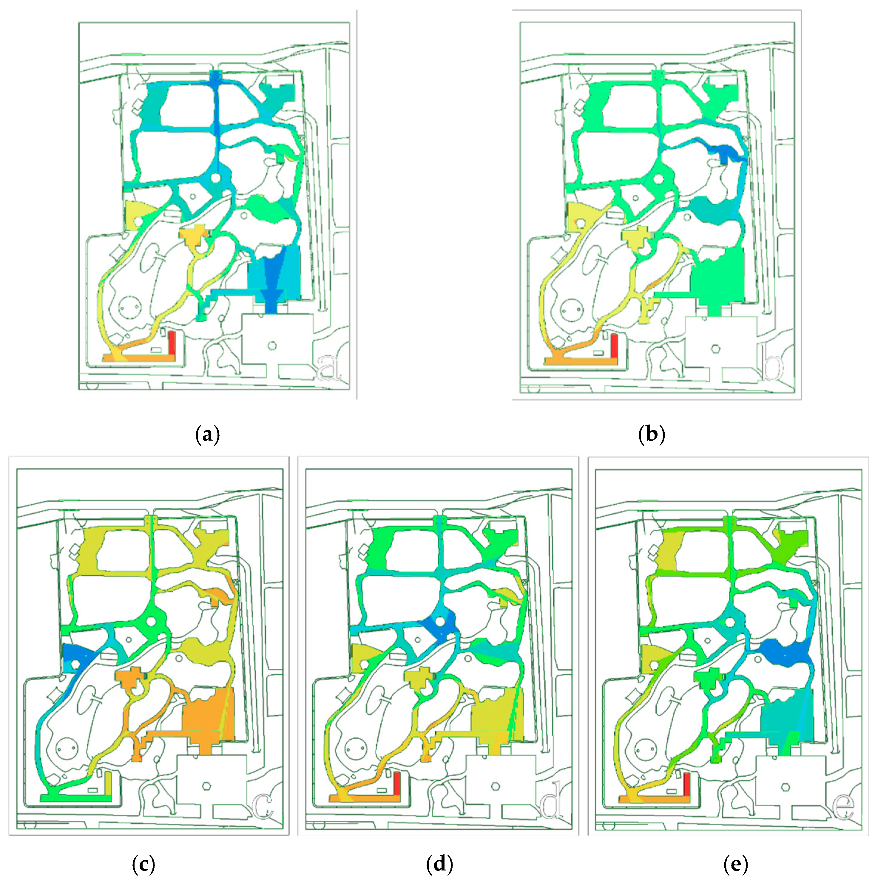
To delve into the spatial layout of Qingxi Garden and validate the simulation results, we utilized visible depth and visual range isotope analyses to scrutinize the garden’s main entrances and exits, as well as several key scenic spots within the park, including the Lanxiu Pavilion, the rockery waterfall, the crepe myrtle vase, and the Philadelphus pekinensis (
Figure 6). Through these methods, we can further quantify the rationality of the spatial arrangement and compare the simulation with the actual conditions.
3.4.1. Depth and Visibility
In assessing the depth visibility at entry and exit points, we calculated the overall depth of the entire scenic area based on data selection points from the entrance and exit points (front and back doors), with increases in depth distinguished by color changes from blue to red. The resulting visible depth map reveals that the front courtyard and back nanmu forest are the most accessible areas. The garden wall corridor is also relatively easy to reach, offering a plausible explanation for the observed traffic flow in this area based on the on-site measurements (
Figure 7).
Upon observing Qingxi Garden, we found that the visible depth of the crepe myrtle vase at the entrance is very low (
Figure 7). To this effect, visitors entering or exiting the garden are most likely to spot this vase first, given its inherent attractiveness. Indeed, the survey data confirm a higher visitor volume around the crepe myrtle vase. This observation, coupled with the analysis of road axes, reinforces the notion that the actual visible depth on the right side of the park is lower than that on the left, making it more accessible and characterized by richer scenery. The visitor flow rate at the rockery waterfall (right side) is similarly higher than the visitor flow rate at the pond (left side).
Examining visibility across different spatial nodes revealed that the entrance and exit points have regular visibility depths, while the wisteria gallery and pond feature deeper visibility. The visual depth levels of the Taiping flower area and wisteria gallery align with that of the crepe myrtle vase, suggesting that, after visitors encounter the vase, they tend to return to the wisteria gallery or proceed directly to the nanmu forest area. Similar observations were made during field investigations, again affirming that our spatial syntax analysis was effective.
The visibility of the crepe myrtle vase indicates that the depth from the back to the garden is low, while the depth from the front to the garden is high; this result correlates with a relatively large visitor flow at the garden gate. Field investigations as well as experimental data suggest that the design and layout of landscape points in the park are rational, with visitor flow rates in the visual center and accessible areas aligning with key elements of the layout. This characteristic enhances tour efficiency, saves time, and promotes a sense of relaxation within the space, enabling visitors to naturally navigate to the main central landscape of the scenic area guided by the road network.
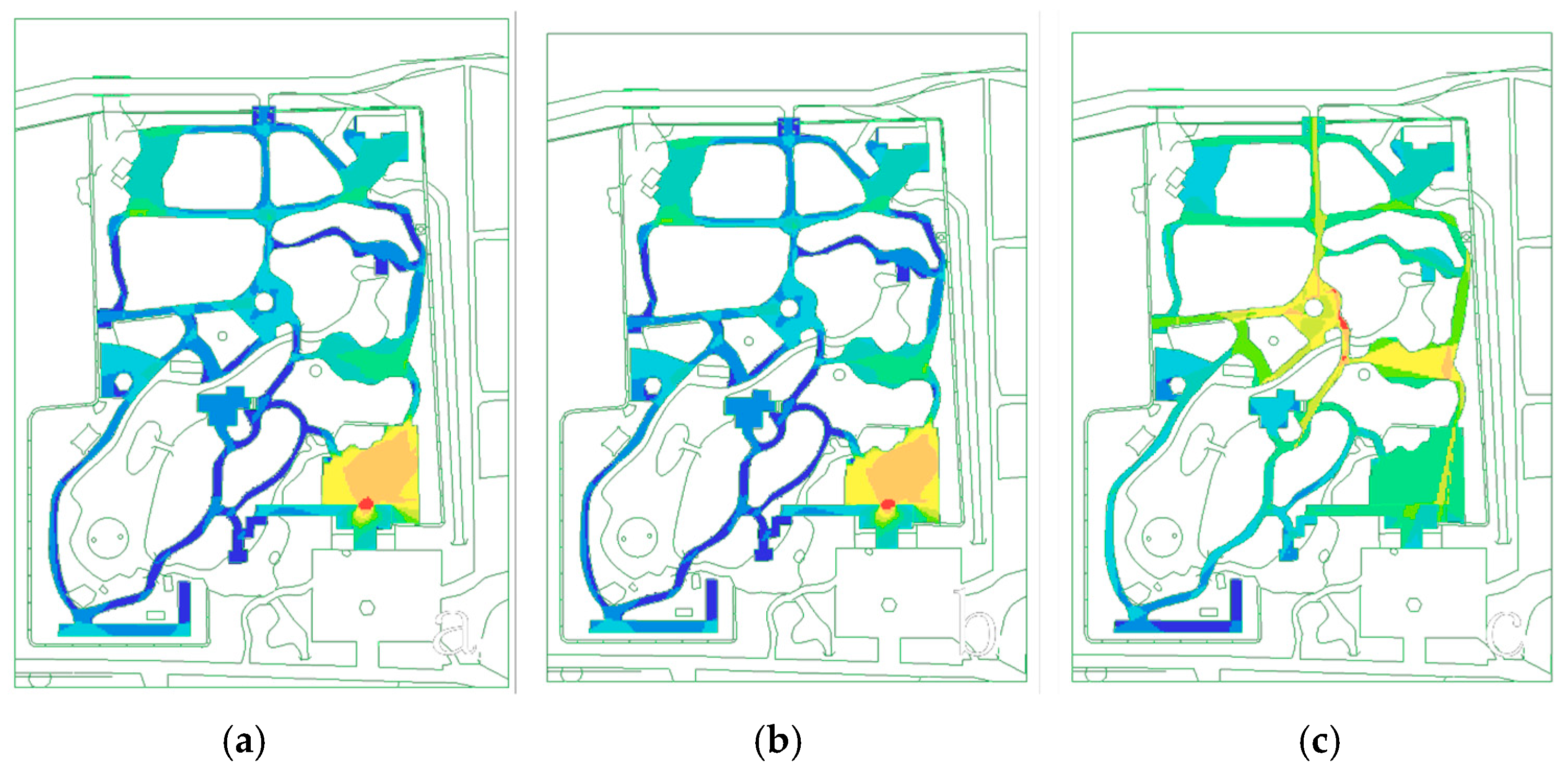
3.4.2. Connection Degree Analysis
In examining the overall connection degree across the scenic area, we found that the front courtyard has maximal connectivity (
Figure 8). Situated at the entrance and exit of the front garden, the front courtyard is an essential junction linking the park’s entry and exit points [
44]. The primary function of these points is to bridge the gap between the park’s interior and exterior, effectively complementing the roles of the front courtyard and park’s interior. While both serve similar functions, they diverge in terms of increasing connections between park space and space outside the park, ultimately facilitating visitors’ navigation to scenic attractions within the park.
Entrance and exit points to the scenic area direct visitors either leftward or forward. To the left, visitors can access the garden wall corridor before further dispersing. Similarly, the front courtyard disperses visitors to multiple other attractions, functioning as a secondary visitor distribution hub. For instance, visitors may be directed to the garden wall corridor at the back, or to the rockery waterfall and Lanxiu Pavilion spots on the right, or to the crepe myrtle vase, pond, and Qingxin Pavilion in the front left.
As a pivotal point for visitor distribution and site integration, the front courtyard’s (upper left) distribution degree should theoretically exceed that of the upper right part of the space. However, the calculation results from DepthmapX space syntax software suggest otherwise. Interestingly, the results indicate that the degree of connection in the upper right corner of the front courtyard surpasses that of the upper left corner, contradicting the inferred distribution degree. We found that the visitor flow rate arriving at the rockery waterfall exceeded that of Qingxin Pavilion, confirming the higher distribution degree in the upper right corner. These findings align with our simulations as well as on-site visitor flow statistics, underscoring tourists’ tendency to prefer conventional and comfortable routes through the space, often favoring the right side. However, these insights are not exhaustive.
3.4.3. Visual Isotopic Analysis
The range isotropy diagram, akin to the connection degree analysis discussed above, led us to several findings. This innovative view in DepthmapX0.8.0 portrays visual range in the form of isotropic radiation, as a more direct and expansive source of information compared to connection degrees [
45]. By comparing both sets of results, we found subtle differences in the grades of the graphs between the nanmu forest and rockery waterfall. This discrepancy suggests that the impact intensity within the isotope range and the connectivity degree may be greater, leading to more intense correlation radiosity concerning the actual on-site conditions.
Upon comparing the visual isotope analysis results and measurement data, we found that the spatial layout of the rockery waterfall is more effective than those of other points in the park. Subsequent actual measurements revealed relatively low foot traffic in the nanmu forest. Although our experimental data suggest significant visitor flow in the nanmu forest, this does not align entirely with the actual data, indicating some limitations in our experiment.
Addressing this disparity would require retrospective correction based on the measurement data, pinpointing differences between actual spatial relationships and simulations to identify underlying issues. This process highlights a challenge inherent to spatial syntax analysis: the inability to update simulation data in real time.
3.4.4. Analysis of Visual Integration Degree
In the spatial diagram depicting the visual integration degree within the park, we found that areas with high degrees of visual integration correspond to the crepe myrtle vase and rockery waterfall; this finding closely correlates with our measurements and on-site observations. Consequently, as per the visual integration degree, the visual center of the park is located at the crepe myrtle vase and rockery waterfall. The apex of visual integration appears at the junction of these two points, establishing it as the visual focal point of the garden.
The spatial relationship between the crepe myrtle vase and rockery waterfall was found to be strategically interconnected and meticulously planned surrounding the vicinity of the garden’s visual center. This layout draws visitors’ attention upward to the bonsai area and downward to the side of the rockery waterfall. These points also exhibit relatively deep visual integration, a feature observed during on-site measurements as well—highly integrated areas offer scenic attractions enjoyed by visitors.
As an example, the three gingko biloba bonsai at the center of the bonsai area are prized by visitors to the gardens. Another popular attraction is an illustration depicting a millennium crepe myrtle tree at the rockery waterfall, known as “Crepe Myrtle of the Buddha Palm”, characterized by coil-like formations resembling Buddha’s palm. Importantly, the use of these visual centers within the park is vividly showcased. Landscape features and facilities are strategically placed to attract visitors, encouraging them to pause and enjoy the space.
Additionally, the visual integration diagram indicates that the connection degree at the bottom side of the pond, particularly at the wisteria gallery, is relatively low. This finding is consistent with on-site observations.
4. Discussion
4.1. Spatial Characteristics of Qingxi Garden
Located within Lidui Park in Dujiangyan Scenic Area, Qingxi Garden is the first bonsai garden of the Southwest [
46]. Characterized by the architectural style of Bashu gardens, the overall architectural form features buildings ventilated on multiple sides, embellished with intricate lattice work and embodying a simple style harmonizing with the local environment [
47]. This design style, in addition to its aesthetic quality, facilitates effective airflow circulation between indoor and outdoor spaces.
Throughout Qingxi Garden, the architectural style remains consistent with the characteristics of Bashu gardens [
48]. As a bonsai garden, the park boasts an extensive array of bonsai displays strategically interspersed throughout the premises [
49]. These displays feature diverse forms and a wide variety of plant species, including numerous ancient trees protected by the state, which constitute a significant portion of the scenic area’s overall botanical landscape [
50].
Situated in the upper reaches of the Minjiang River, the designers of Qingxi Garden adeptly incorporated local plant materials and building resources into its construction [
47]. The naturalistic rockery waterfall landscape seamlessly merges with the surrounding environment, having been meticulously constructed using time-tested stacking techniques. Representative of Western Shu gardens, it also exudes a humanistic ambiance evident in the couplets adorning the gates, Luxiu Pavilion and Qingxin Pavilion. The thematic content of these couplets accords with the local scenery.
Qingxi Garden also boasts a diverse array of garden elements and facilities artfully integrated within its compact footprint [
51]. Its spatial structure is noteworthy, where varying elevations offer visitors unique visual perspectives as they traverse the park. The design of the road network, rising and falling in tandem with the terrain, adds to its appeal while exhibiting a scientific approach to design.
In the analysis of the depth, connectivity, and integration of various spatial nodes and pathways within Qingxi Garden, it was observed that spatial nodes characterized by low depth values and high connectivity are predominantly located on the right side of the garden. Subsequent analyses, which included the distribution of pedestrian traffic across each spatial node, supported the findings obtained from simulations. To further explore the rational arrangement of spatial nodes within Qingxi Garden, visible depth and visual range isotope analyses were utilized to assess the visual depth, connectivity, isotropy, and integration of significant scenic locations. The results indicated that these key scenic spots generally exhibit low visual depth in conjunction with high visual connectivity, isotropy, and integration.
By integrating field research with surveys capturing visitor flow, the precision of the simulation outcomes was enhanced, thereby bolstering the reliability of the experimental data. Ultimately, we delineated the spatial structural layout strategies of Qingxi Garden, positioning bonsai as focal points within open areas to diminish their spatial node depth values, which, in turn, augmented visual connectivity and isotropy, rendering them more prominent and appealing to visitors and further enhancing visual integration.
Moreover, by enriching the roads connecting bonsai scenic nodes and elevating the connectivity values of spatial nodes, the integration of key scenic spots was improved, concentrating significant landscape nodes in proximate areas, thus facilitating their discovery and accessibility, particularly on the right side of the garden. Consequently, this area is characterized by a richer scenic experience and a higher volume of pedestrian traffic. However, our research also revealed discrepancies between certain spatial nodes identified as key landscapes in simulation values and the actual conditions observed. Through on-site investigations, it became evident that the layout of landscape architecture and the associated rest and entertainment facilities significantly influence visitor distribution. Some areas (notably, the wisteria gallery) remain relatively remote; this trait results in limited visitor counts despite notable attractions like the “Yuping Lubao” bonsai. Additionally, certain theoretically suitable locations lack garden materials or facilities, detracting from their appeal. This inconsistency is an inherent limitation of space syntax simulations and necessitates a reciprocal validation with field research and software simulations.
Furthermore, the relationship between internal park roads and external connecting roads was cleverly established to enhance the gardens’ allure. However, challenges persist due to the gardens’ location and inadequate signage, which may prevent tourists from discovering its exceptional bonsai displays.
4.2. Limitations, Potential Future Research, and Guidance for Modern Garden Design
This article examines the application of space syntax as a method for quantitatively analyzing and assessing the spatial layout of Qingxi Garden. However, there are certain limitations in the spatial syntax analysis of the garden. Plants are dynamic elements that change with the seasons, leading to different phenological stages. Since the research was conducted solely in the summer, the analysis does not fully account for the diverse plant life present in the garden. While the organization of visual sequences is captured in the syntactic analysis of Qingxi Garden’s spatial structure, the subjective experiences of visitors navigating the space are not reflected in space syntax evaluations. Furthermore, space syntax is unable to account for semi-transparent divisions that influence visual–spatial relationships, such as those created by windows. In more open areas or those with windows, walls and other markers are often removed to avoid miscalculations in the model, which helps minimize errors stemming from model recognition issues.
For future space syntax research, it may be beneficial to document plant elements across different seasons, assess facilities designed for rest and recreation within the garden, and incorporate 3D scanning technology to model irregular architectural features like walls. Furthermore, future studies could broaden the examination of various representative spatial gardening methods used in Xishu gardens, enabling comparative assessments of their complexity and diversity.
Space syntax provides a clear quantitative analysis and evaluation of spatial structure, ensuring the scientific nature of the analysis of the spatial structure of Qingxi Garden and its applicability to the spatial analysis of Xishu gardens. The construction of Qingxi Garden not only retains the characteristic of highly fitting the geographical environment in the garden construction of Western Sichuan but also integrates traditional gardening techniques, such as piling up hills and dredge waterways, with specific cultural elements, such as the design of bonsai exhibitions, creating a bonsai art display space that feels like being in nature. In modern garden design, one can draw on the gardening techniques of Qingxi Garden, blurring artificialization and mimicking nature. Moreover, it is possible to amplify the cultural elements within the scenic area, place them in visually prominent areas, and plan the tour route reasonably, allowing people to spontaneously experience the beauty of the garden and absorb cultural knowledge in the garden design.
In the aftermath of the COVID-19 pandemic, urban tourism has witnessed significant expansion, which not only contributes to the economic advancement of cities but also presents challenges regarding the efficient management and organization of urban cultural resources. Urban landscapes have played a crucial role in influencing the perception of a city and have emerged as significant platforms for showcasing and disseminating regional culture [
52]. The development of an urban green space system must be approached in a systematic and rational manner, ensuring that it is congruent with the social and economic progress of the city [
53]. Yibin Li established a novel spatial equilibrium model to identify the additional value associated with diverse urban green spaces and urban green policies within the city [
54]. Doaa A’s recommendation is that cities should promote greater collaboration between urban tourism development and spatial planning [
55]. The Dujiangyan Scenic Area serves as a notable illustration of the deliberate design of urban landscape green spaces, effectively incorporating the historical and cultural significance of the Dujiangyan Irrigation System. This thoughtful integration has elevated the area to a prominent tourist attraction. Within this context, Qingxi Garden, situated in Lidu Park of Dujiangyan, exemplifies the characteristics of Xishu gardens. It harmoniously integrates local bonsai culture, thereby providing visitors with a pleasant and immersive travel experience and elevating the cultural value of the scenic area.
5. Conclusions
In this study, we comprehensively measured the space of Qingxi Garden and conducted quantitative research through simulations and innovative visualized graphs. The simulation data derived from spatial syntax analyses closely mirrored actual on-site observations. By merging spatial syntax theory with field investigation, we gauged the rationality of the garden’s layout and gained some noteworthy insights into the spatial structures of traditional garden landscapes.
By comprehensively exploring Xishu Gardens and Qingxi Garden in Dujiangyan Scenic Area, we found that Xishu Gardens have a distinct style and unique, artistic methods of construction. These developments were influenced by local climatic conditions as well as anthropogenic and cultural factors. Over time and with increased scholarly attention, Qingxi Gardens have gained significant public recognition and become a popular tourist attraction. The scientific gardening techniques employed in the gardens, exemplified by their extensive layout, elevate them to a spatial level comparable to other garden schools. Qingxi Gardens’ designers excelled in amalgamating and showcasing various strengths, thereby enriching the diversity of attractions within the park and drawing many visitors.
Based on our analysis, we reached following conclusions:
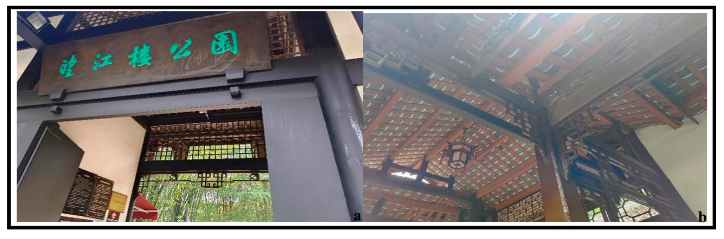
As the first bonsai garden in Xishu, Qingxi Garden embodies the typical architectural and stylistic features found in other renowned gardens of the region. The Sichuan Basin, where Xishu Gardens are located, experiences a consistently wet and humid climate. The design philosophy of Xishu Gardens emphasizes a ventilated hollow structure, contributing to a pleasant touring experience for visitors by keeping the space physically comfortable, such as Wangjianglou Park and Du Fu’s Thatched Cottage (
Figure 9).
By combining data from spatial syntax simulations with field observations, we found that the design in Xishu Gardens prioritizes spatial visual depth, road connectivity, and spatial integration. Areas with more visual depth typically attract fewer visitors, whereas those with higher road connectivity and integration degrees are more easily accessible and receive more visitors. These areas should be regarded as key focal points within a garden.
While spatial integration data and visitor activities collected from field measurements offered insights into the central area, the appeal of the garden was also influenced by an array of other factors. For instance, in Qingxi Garden, the strategic placement of rockeries and the design of screen walls significantly enhance the sightseeing experience around the cascading rockery waterfall. This finding suggests that the thoughtful incorporation of design elements and on-site amenities can alter both the central focal points and visual allure of a garden, ultimately shaping the overall tourist experience.


